A Technology of Forest Fire Smoke Detection Using Dual-Polarization Weather Radar
Abstract
1. Introduction
2. Materials and Methods
2.1. Study Area and Data
2.1.1. Satellite Dataset
2.1.2. Dual-Polarization Weather Radar Data
2.2. Research Methods for Forest Fire Smoke Detection
2.2.1. Fire Echo Intensity Index
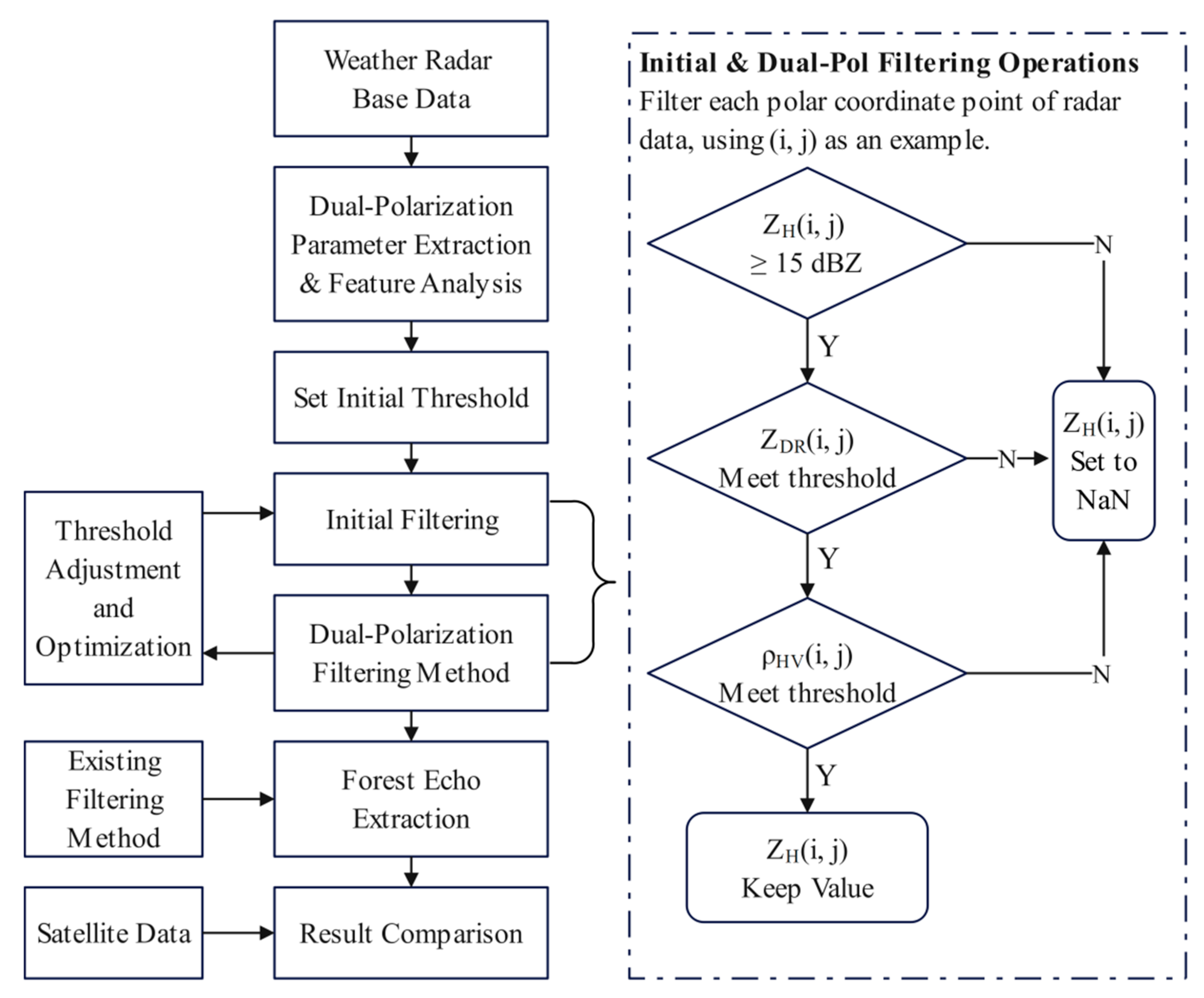
2.2.2. Dual-Polarization Parameter Filtering Method
3. Forest Fire Monitoring Using Dual-Polarization Radar: A Case Study
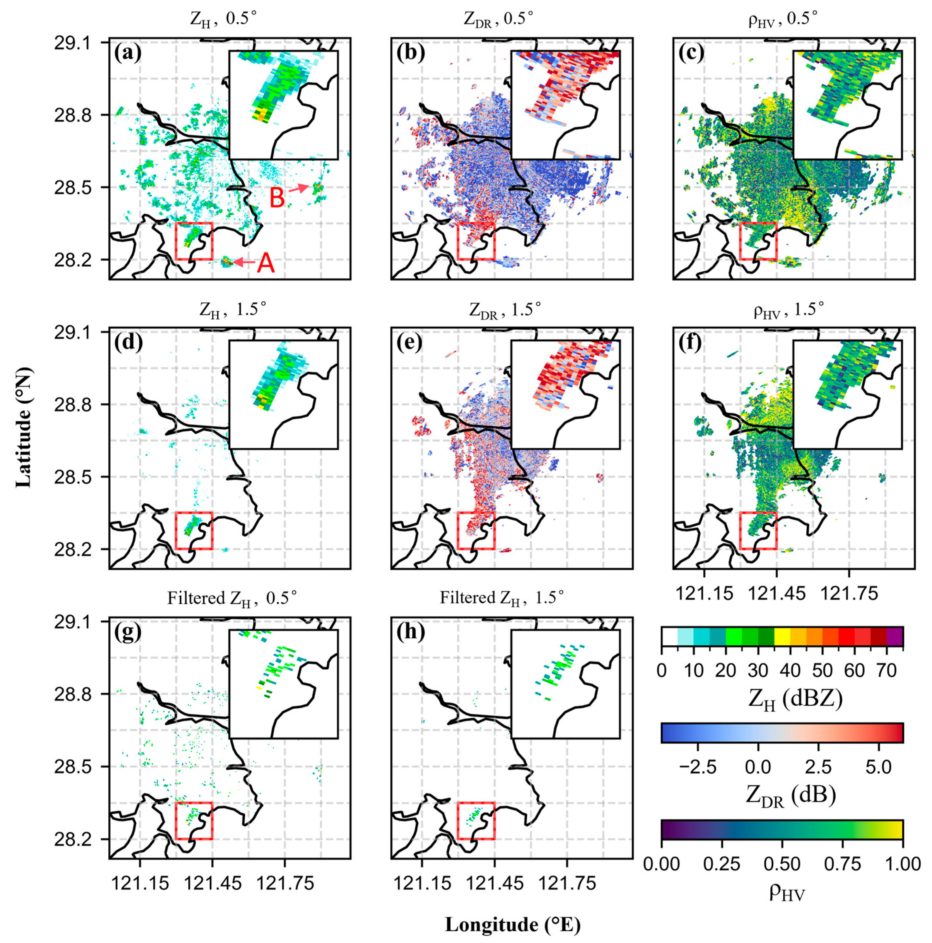
3.1. Polarimetric Feature Extraction and Forest Fire Echo Filtering
3.2. Dynamic Tracking of Forest Fire Echoes and Comparison with Satellite Observations
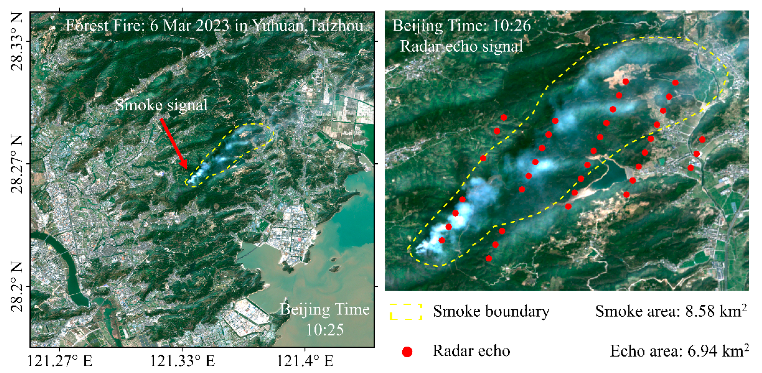
- Directional feature: Both radar reflectivity maps and satellite images show that the forest fire smoke and echoes are distributed in a banded pattern extending from southwest to northeast, indicating a clear direction of fire spread. Weather radar’s continuous observation capability enables real-time tracking of fire spread paths, supporting rapid prediction of fire propagation trends.
- Intensity feature: The satellite imagery indicate that the area near the smoke origin has the highest concentration, corresponding well with the actual fire location (121.34° E, 28.26° N). At the corresponding time, the strongest radar echo appears at the southwest end, with a maximum value at (121.341° E, 28.269° N), which is highly consistent with the actual fire point. This consistency demonstrates the radar’s ability to accurately identify high-intensity fire regions, providing a basis for fire source localization and fire intensity assessment.
- Diffusion feature: Satellite imagery shows the smoke spreading along the propagation direction and expanding sideways, a pattern also observed in radar echo maps. Radar’s high-frequency detection can capture this diffusion in real time, aiding in understanding fire spread dynamics.
- Boundary feature and quantitative estimation capability: Satellite imagery, with boundary extracted via ArcGIS (yellow dashed line, Figure 7), estimate smoke coverage at 8.58 km2. Radar image echo points (red dots, Figure 7) align closely with this region. By summing radar resolution cell areas in polar coordinates, derived from radar data, the echo coverage is estimated at 6.94 km2. The errors mainly stem from systematic errors of the satellite and radar systems, including satellite non-orthorectification errors [40] and radar effects such as Earth’s curvature and atmospheric refraction [18]. Additional discrepancies arise from manual delineation of smoke boundaries in satellite imagery and from approximating radar echo areas using range-bin equivalence. The close agreement between these two estimates indicates that weather radar has the capability for quantitative delineation and estimation of fire smoke extent, demonstrating its potential for further outlining fire boundaries in fire monitoring.
4. Forest Fire Monitoring Application
4.1. Application of Dual-Polarization Filtering in Multiple Forest Fires
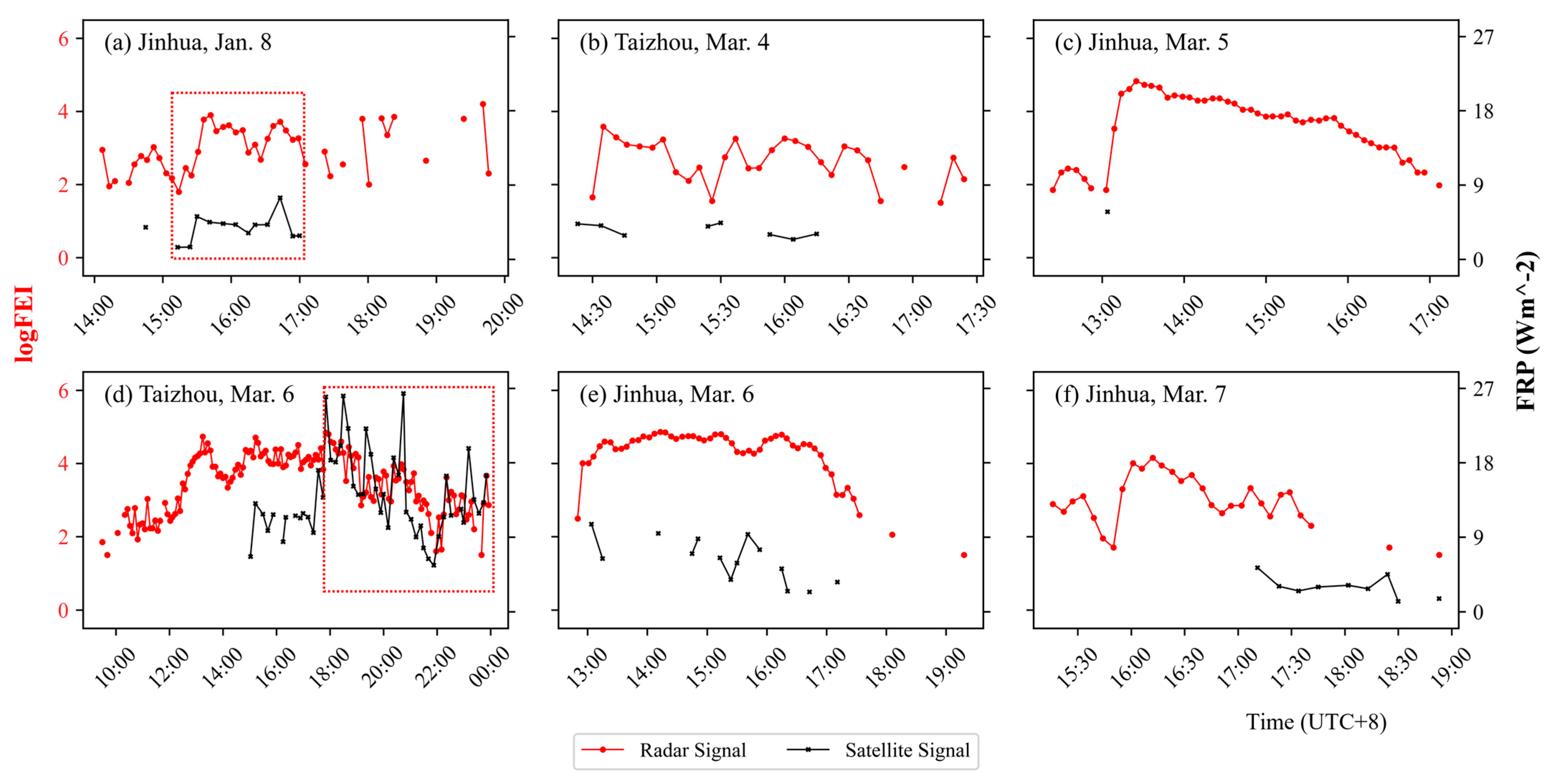
4.2. Comparative Analysis of Radar and Satellite Signals for Forest Fire Monitoring
5. Discussion
5.1. Physical Origins of Radar Signals and Differences from Satellite Observation Mechanisms
5.2. Limitations of the Dual-Polarization Filtering Method
- Ground clutter cannot be fully eliminated at the 0.5° elevation angle, which constitutes a key limitation of this study. Although the dual-polarization filtering method performed well overall across the six cases, some residual clutter remained due to the overlap between the polarimetric signatures of clutter and fire-related echoes—for example, ground clutter typically exhibits ZDR values distributed across its full range [45]. Under conditions of ambiguous boundaries or overlapping signals, fixed-threshold methods may struggle to fully distinguish fire echoes from non-meteorological noise. To balance the completeness of fire signals and filtering accuracy, the current strategy adopts conservative parameter settings, allowing limited residual clutter. This issue was particularly evident in the two Taizhou cases (Figure 3g and Figure 8b), both of which were observed by the same radar station. By overlaying high-resolution ASTER GDEM V3 elevation data (30 m spatial resolution), we found that approximately 41.6% of the residual clutter pixels in the 6 March case corresponded to terrain elevations above the radar beam height. Combined with the substantial reduction in clutter at the 1.5° elevation angle, this supports the inference that the clutter is primarily caused by terrain blockage.
- Limitations of Threshold Selection: although the selection of dual-polarization parameter thresholds is based on experimental analysis, it still relies on empirical judgment and manual trade-offs, which limits its general applicability. While the threshold combination has been validated in additional wildfire cases, the number of validation samples remains limited and the study area is relatively concentrated; therefore, its applicability under different geographical settings, terrain conditions, and fire types requires further verification.
- Limitations in FEI Validation: although the proposed Fire Echo Intensity (FEI) index effectively captures the long-term evolution of fire intensity and exhibits high consistency with satellite observations, it lacks direct validation using high spatiotemporal resolution ground-based measurements. In particular, its capability to characterize short-term fluctuations in fire intensity has not yet been fully assessed.
5.3. Future Work and Outlook
6. Conclusions
Author Contributions
Funding
Data Availability Statement
Conflicts of Interest
Abbreviations
| ZH | Horizontal Reflectivity Factor |
| ZDR | Differential Reflectivity |
| Correlation Coefficient | |
| FEI | Fire Echo Intensity Index |
| FRP | Fire Radiative Power |
References
- Ellis, T.M.; Bowman, D.M.J.S.; Jain, P.; Flannigan, M.D.; Williamson, G.J. Global Increase in Wildfire Risk Due to Climate-Driven Declines in Fuel Moisture. Glob. Change Biol. 2022, 28, 1544–1559. [Google Scholar] [CrossRef]
- Cunningham, C.X.; Williamson, G.J.; Bowman, D.M.J.S. Increasing Frequency and Intensity of the Most Extreme Wildfires on Earth. Nat. Ecol. Evol. 2024, 8, 1420–1425. [Google Scholar] [CrossRef]
- Jones, M.W.; Veraverbeke, S.; Andela, N.; Doerr, S.H.; Kolden, C.; Mataveli, G.; Pettinari, M.L.; Le Quéré, C.; Rosan, T.M.; van der Werf, G.R.; et al. Global Rise in Forest Fire Emissions Linked to Climate Change in the Extratropics. Science 2024, 386, eadl5889. [Google Scholar] [CrossRef] [PubMed]
- Liu, Y.; Stanturf, J.; Goodrick, S. Trends in Global Wildfire Potential in a Changing Climate. For. Ecol. Manag. 2010, 259, 685–697. [Google Scholar] [CrossRef]
- Payra, S.; Sharma, A.; Verma, S. Application of Remote Sensing to Study Forest Fires. In Atmospheric Remote Sensing; Elsevier: Amsterdam, The Netherlands, 2023; pp. 239–260. [Google Scholar]
- Mohapatra, A.; Trinh, T. Early Wildfire Detection Technologies in Practice—A Review. Sustainability 2022, 14, 12270. [Google Scholar] [CrossRef]
- Barmpoutis, P.; Papaioannou, P.; Dimitropoulos, K.; Grammalidis, N. A Review on Early Forest Fire Detection Systems Using Optical Remote Sensing. Sensors 2020, 20, 6442. [Google Scholar] [CrossRef]
- Szpakowski, D.M.; Jensen, J.L.R. A Review of the Applications of Remote Sensing in Fire Ecology. Remote Sens. 2019, 11, 2638. [Google Scholar] [CrossRef]
- Honary, R.; Shelton, J.; Kavehpour, P. A Review of Technologies for the Early Detection of Wildfires. ASME Open J. Eng. 2025, 4, 040803. [Google Scholar] [CrossRef]
- Allison, R.S.; Johnston, J.M.; Craig, G.; Jennings, S. Airborne Optical and Thermal Remote Sensing for Wildfire Detection and Monitoring. Sensors 2016, 16, 1310. [Google Scholar] [CrossRef]
- Giglio, L.; Schroeder, W.; Justice, C.O. The Collection 6 MODIS Active Fire Detection Algorithm and Fire Products. Remote Sens. Environ. 2016, 178, 31–41. [Google Scholar] [CrossRef]
- Giglio, L.; Boschetti, L.; Roy, D.P.; Humber, M.L.; Justice, C.O. The Collection 6 MODIS Burned Area Mapping Algorithm and Product. Remote Sens. Environ. 2018, 217, 72–85. [Google Scholar] [CrossRef]
- Zhang, L.; Zhang, Q.; Yang, Q.; Yue, L.; He, J.; Jin, X.; Yuan, Q. Near-Real-Time Wildfire Detection Approach with Himawari-8/9 Geostationary Satellite Data Integrating Multi-Scale Spatial–Temporal Feature. Int. J. Appl. Earth Obs. Geoinf. 2025, 137, 104416. [Google Scholar] [CrossRef]
- Yang, J.; Zhang, Z.; Wei, C.; Lu, F.; Guo, Q. Introducing the New Generation of Chinese Geostationary Weather Satellites, Fengyun-4. Bull. Am. Meteorol. Soc. 2017, 98, 1637–1658. Available online: https://journals.ametsoc.org/view/journals/bams/98/8/bams-d-16-0065.1.xml (accessed on 21 July 2025). [CrossRef]
- Tian, X.-R.; McRae, D.J.; Li, S.-F.; Wang, M.-Y.; Li, H. Satellite Remote-Sensing Technologies Used in Forest Fire Management. J. For. Res. 2005, 16, 73–78. [Google Scholar] [CrossRef]
- Wooster, M.J.; Roberts, G.J.; Giglio, L.; Roy, D.P.; Freeborn, P.H.; Boschetti, L.; Justice, C.; Ichoku, C.; Schroeder, W.; Davies, D.; et al. Satellite Remote Sensing of Active Fires: History and Current Status, Applications and Future Requirements. Remote Sens. Environ. 2021, 267, 112694. [Google Scholar] [CrossRef]
- Saltikoff, E.; Friedrich, K.; Soderholm, J.; Lengfeld, K.; Nelson, B.; Becker, A.; Hollmann, R.; Urban, B.; Heistermann, M.; Tassone, C. An Overview of Using Weather Radar for Climatological Studies: Successes, Challenges, and Potential. Bull. Am. Meteorol. Soc. 2019, 100, 1739–1752. [Google Scholar] [CrossRef]
- Doviak, R.J.; Zrnić, D.S. Doppler Radar and Weather Observations, 2nd ed.; Academic Press: San Diego, CA, USA, 1993; 562p, ISBN 978-0122214226. [Google Scholar]
- Melnikov, V.M.; Zrnić, D.S.; Rabin, R.M.; Zhang, P. Radar polarimetric signatures of fire plumes in Oklahoma. Geophys. Res. Lett. 2008, 35, L14811. [Google Scholar] [CrossRef]
- McCarthy, N.; Guyot, A.; Dowdy, A.; McGowan, H. Wildfire and Weather Radar: A Review. J. Geophys. Res. Atmos. 2019, 124, 266–286. [Google Scholar] [CrossRef]
- Lang, T.J.; Rutledge, S.A.; Dolan, B.; Krehbiel, P.; Rison, W.; Lindsey, D.T. Lightning in Wildfire Smoke Plumes Observed in Colorado during Summer 2012. Mon. Weather Rev. 2014, 142, 489–507. [Google Scholar] [CrossRef]
- Lareau, N.P.; Donohoe, A.; Roberts, M.; Ebrahimian, H. Tracking Wildfires with Weather Radars. J. Geophys. Res. Atmos. 2022, 127, e2021JD036158. [Google Scholar] [CrossRef]
- Shu, S.; Chen, Y.; Cao, S.; Zhang, B.; Fang, C.; Xu, J. Monitoring and Alarm Method for Wildfires near Transmission Lines with multi-Doppler Weather Radars. IET Gener. Transm. Distrib. 2023, 17, 2055–2069. [Google Scholar] [CrossRef]
- Zrnic, D.; Zhang, P.; Melnikov, V.; Mirkovic, D. Of Fire and Smoke Plumes, Polarimetric Radar Characteristics. Atmosphere 2020, 11, 363. [Google Scholar] [CrossRef]
- Krishna, M.; Saide, P.E.; Ye, X.; Turney, F.A.; Hair, J.W.; Fenn, M.; Shingler, T. Evaluation of Wildfire Plume Injection Heights Estimated from Operational Weather Radar Observations Using Airborne Lidar Retrievals. J. Geophys. Res. Atmos. 2024, 129, e2023JD039926. [Google Scholar] [CrossRef]
- Bian, R.; Chen, K.; Li, G.; Wang, Z.; Qiu, Y.; Bai, H.; Kong, W. Evaluation of Three Algorithms and Forest Fire Risk Prediction in Zhejiang Province of China. Forests 2024, 15, 2146. [Google Scholar] [CrossRef]
- Li, X.; Liu, L.; Qi, S. Forest Fire Hazard during 2000–2016 in Zhejiang Province of the Typical Subtropical Region, China. Nat. Hazards 2018, 94, 975–977. [Google Scholar] [CrossRef]
- Chen, Z.; Wang, M.; Zhang, H.; Lin, S.; Guo, Z.; Jiang, Y.; Zhou, C. Long-Term Change in Low-Cloud Cover in Southeast China during Cold Seasons. Atmos. Ocean. Sci. Lett. 2022, 15, 100222. [Google Scholar] [CrossRef]
- Yang, Y.; Zhao, C.; Fan, H. Spatiotemporal Distributions of Cloud Properties over China Based on Himawari-8 Advanced Himawari Imager Data. Atmos. Res. 2020, 240, 104927. [Google Scholar] [CrossRef]
- Jang, E.; Kang, Y.; Im, J.; Lee, D.-W.; Yoon, J.; Kim, S.-K. Detection and Monitoring of Forest Fires Using Himawari-8 Geostationary Satellite Data in South Korea. Remote Sens. 2019, 11, 271. [Google Scholar] [CrossRef]
- Phiri, D.; Simwanda, M.; Salekin, S.; Nyirenda, V.R.; Murayama, Y.; Ranagalage, M. Sentinel-2 Data for Land Cover/Use Mapping: A Review. Remote Sens. 2020, 12, 2291. [Google Scholar] [CrossRef]
- Yang, Z.; Qi, Y.; Zhang, Z.; Li, D. Can CINRAD Radar With VCP-21 Mode Capture the Accumulated Rainfall Pattern and Intensity of Fast-Moving Storms? IEEE Trans. Geosci. Remote Sens. 2024, 62, 4100813. [Google Scholar] [CrossRef]
- Oh, Y.-A.; Kim, H.-L.; Suk, M.-K. Clutter Elimination Algorithm for Non-Precipitation Echo of Radar Data Considering Meteorological and Observational Properties in Polarimetric Measurements. Remote Sens. 2020, 12, 3790. [Google Scholar] [CrossRef]
- Fabry, F. Radar Meteorology: Principles and Practice; Cambridge University Press: Cambridge, UK, 2015; 552p, ISBN 978-1107024961. [Google Scholar]
- National Weather Service. Field Guide Glossary: D’s. Available online: https://www.weather.gov/spotterguide/glossary_d (accessed on 23 July 2025).
- Duff, T.J.; Chong, D.M.; Penman, T.D. Quantifying Wildfire Growth Rates Using Smoke Plume Observations Derived from Weather Radar. Int. J. Wildland Fire 2018, 27, 514–524. [Google Scholar] [CrossRef]
- Park, H.S.; Ryzhkov, A.V.; Zrnić, D.S.; Kim, K.-E. The Hydrometeor Classification Algorithm for the Polarimetric WSR-88D: Description and Application to an MCS. Weather Forecast. 2009, 24, 730–748. [Google Scholar] [CrossRef]
- Martin, W.J.; Shapiro, A. Discrimination of Bird and Insect Radar Echoes in Clear Air Using High-Resolution Radars. J. Atmos. Ocean. Technol. 2007, 24, 1215–1230. [Google Scholar] [CrossRef]
- Deng, M.; Volkamer, R.M.; Wang, Z.; Snider, J.R.; Kille, N.; Romero-Alvarez, L.J. Wildfire Smoke Observations in the Western United States from the Airborne Wyoming Cloud Lidar during the BB-FLUX Project. Part II: Vertical Structure and Plume Injection Height. J. Atmos. Ocean. Technol. 2022, 39, 545–558. [Google Scholar] [CrossRef]
- Pandžic, M.; Mihajlovic, D.; Pandžic, J.; Pfeifer, N. Assessment of the geometric quality of sentinel-2 data. Int. Arch. Photogramm. Remote Sens. Spat. Inf. Sci. 2016, XLI-B1, 489–494. [Google Scholar] [CrossRef][Green Version]
- Liu, X.; He, B.; Quan, X.; Yebra, M.; Qiu, S.; Yin, C.; Liao, Z.; Zhang, H. Near Real-Time Extracting Wildfire Spread Rate from Himawari-8 Satellite Data. Remote Sens. 2018, 10, 1654. [Google Scholar] [CrossRef]
- Aydell, T.B.; Clements, C.B. Mobile Ka-band polarimetric Doppler radar observations of wildfire smoke plumes. Mon. Weather Rev. 2021, 149, 2827–2844. [Google Scholar] [CrossRef]
- Melnikov, V.M.; Zrnic, D.S.; Rabin, R.M. Polarimetric Radar Properties of Smoke Plumes: A Model. J. Geophys. Res. Atmos. 2009, 114, D21. [Google Scholar] [CrossRef]
- Koo, E.; Linn, R.R.; Pagni, P.J.; Edminster, C.B. Modelling Firebrand Transport in Wildfires Using HIGRAD/FIRETEC. Int. J. Wildland Fire 2012, 21, 396–417. [Google Scholar] [CrossRef]
- Melnikov, V.; Zrnic, D.; Free, A.; Ice, R.; Macemon, R. Monitoring Radar Calibration Using Ground Clutter; NOAA/National Severe Storms Laboratory: Norman, OK, USA, 2017. [Google Scholar]
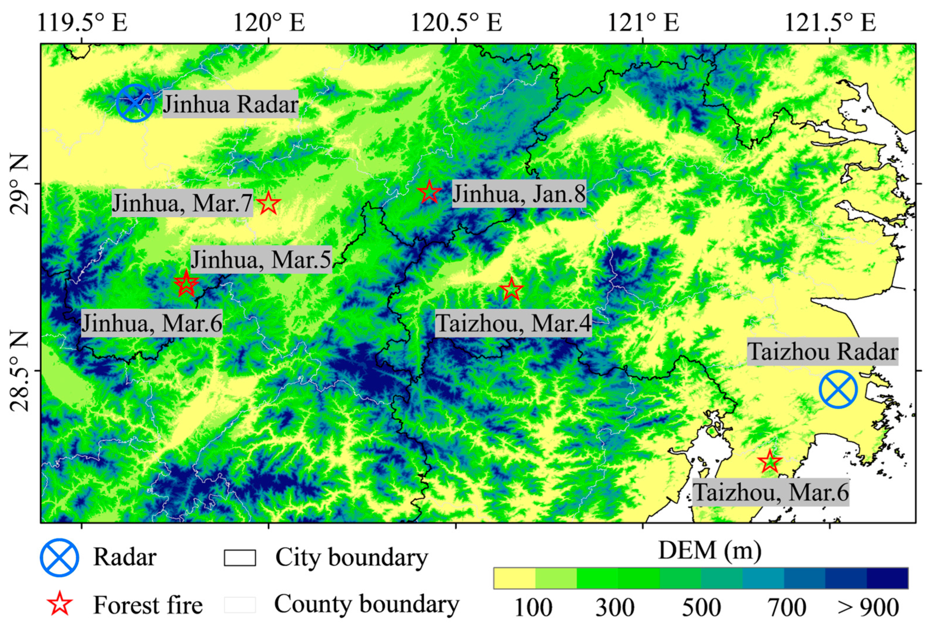




| No. | Date | Location | Longitude (°E) | Latitude (°N) | Distance (km) |
|---|---|---|---|---|---|
| 1 | 6 March 2023 | Yuhuan, Taizhou | 121.34 | 28.26 | 30 |
| 2 | 4 March 2023 | Xianju, Taizhou | 120.65 | 28.72 | 82 |
| 3 | 5 March 2023 | Wuyi, Jinhua | 119.78 | 28.74 | 54 |
| 4 | 6 March 2023 | Wuyi, Jinhua | 119.78 | 28.73 | 54 |
| 5 | 7 March 2023 | Yongkang, Jinhua | 120.00 | 28.95 | 39 |
| 6 | 8 January 2023 | Pan’an, Jinhua | 120.43 | 28.98 | 85 |
| No. | Date | Location | Radar | Satellite | Time Difference |
|---|---|---|---|---|---|
| 1 | 6 March 2023 | Yuhuan, Taizhou | 9:30 | 15:02 | >5 h |
| 2 | 4 March 2023 | Xianju, Taizhou | 14:30 | 14:23 | −7 min (Close) |
| 3 | 5 March 2023 | Wuyi, Jinhua | 12:24 | 13:04 | 40 min |
| 4 | 6 March 2023 | Wuyi, Jinhua | 12:50 | 13:04 | 14 min |
| 5 | 7 March 2023 | Yongkang, Jinhua | 15:16 | 17:11 | 115 min |
| 6 | 8 January 2023 | Pan’an, Jinhua | 14:18 | 14:45 | 27 min |
Disclaimer/Publisher’s Note: The statements, opinions and data contained in all publications are solely those of the individual author(s) and contributor(s) and not of MDPI and/or the editor(s). MDPI and/or the editor(s) disclaim responsibility for any injury to people or property resulting from any ideas, methods, instructions or products referred to in the content. |
© 2025 by the authors. Licensee MDPI, Basel, Switzerland. This article is an open access article distributed under the terms and conditions of the Creative Commons Attribution (CC BY) license (https://creativecommons.org/licenses/by/4.0/).
Share and Cite
Jiang, M.; Bai, M.; He, Z.; Fan, G.; Tang, M.; Liang, Z. A Technology of Forest Fire Smoke Detection Using Dual-Polarization Weather Radar. Forests 2025, 16, 1471. https://doi.org/10.3390/f16091471
Jiang M, Bai M, He Z, Fan G, Tang M, Liang Z. A Technology of Forest Fire Smoke Detection Using Dual-Polarization Weather Radar. Forests. 2025; 16(9):1471. https://doi.org/10.3390/f16091471
Chicago/Turabian StyleJiang, Mengfei, Miao Bai, Zhonghua He, Gaofeng Fan, Minghao Tang, and Zhuoran Liang. 2025. "A Technology of Forest Fire Smoke Detection Using Dual-Polarization Weather Radar" Forests 16, no. 9: 1471. https://doi.org/10.3390/f16091471
APA StyleJiang, M., Bai, M., He, Z., Fan, G., Tang, M., & Liang, Z. (2025). A Technology of Forest Fire Smoke Detection Using Dual-Polarization Weather Radar. Forests, 16(9), 1471. https://doi.org/10.3390/f16091471


