Article

Spatiotemporal Dynamics and Driving Factors of Arbor Forest Carbon Stocks in Yunnan Province, China (2016–2020)

1
Yunnan Institute of Forest Inventory and Planning, Kunming 650051, China
2
College of Forestry, Southwest Forestry University, Kunming 650224, China
*
Author to whom correspondence should be addressed.
These authors contributed equally to this work.
Forests 2025, 16(7), 1076; https://doi.org/10.3390/f16071076 (registering DOI)
Submission received: 16 May 2025 / Revised: 17 June 2025 / Accepted: 26 June 2025 / Published: 27 June 2025
(This article belongs to the Special Issue Forest Inventory: The Monitoring of Biomass and Carbon Stocks)

Abstract

In the context of accelerating global climate change, the accurate quantification of forest carbon sequestration at the regional scale is of critical importance to estimate carbon budgets and formulate targeted ecological policies. This study systematically investigated the spatiotemporal dynamics and driving mechanisms of arbor forest carbon stocks between 2016 and 2020 in Yunnan Province, China. Based on the “One Map” forest resource inventory, the continuous biomass expansion factor (CBEF) method, standard deviational ellipse (SDE) analysis, and multiple linear regression (MLR) modeling, the results showed the following. (1) Arbor forest carbon stocks steadily increased from 832.13 Mt to 938.84 Mt, and carbon density increased from 41.92 to 42.32 t C·hm−2. Carbon stocks displayed a dual high pattern in the northwest and southwest, with lower values in the central and eastern regions. (2) The spatial centroid of carbon stocks shifted 4.8 km eastward, driven primarily by afforestation efforts in central and eastern Yunnan. (3) The MLR results revealed that precipitation and economic development were significant positive drivers, whereas temperature, elevation, and anthropogenic disturbances were major limiting factors. A negative correlation to afforestation area indicated a diminished need for new plantations as forest quality and quantity improved. These results provided a theoretical foundation for spatially differentiated carbon sequestration strategies in Yunnan, providing key insights for reinforcing ecological security in Southwest China and enhancing national carbon neutrality objectives.

1. Introduction

In the context of intensifying global climate change, stabilizing and enhancing the carbon sink function of terrestrial ecosystems has become a critical pathway for mitigating the greenhouse effect and achieving carbon peaking and carbon neutrality targets [1]. As one of the largest terrestrial carbon pools, forests play a pivotal role in sequestering atmospheric carbon and maintaining carbon balance at both regional and global scales [2]. Forest carbon storage and its density are not only critical indicators for assessing carbon sequestration capacity but also essential metrics reflecting the structural stability and functional integrity of forest ecosystems [3].
In recent years, the Forest Management Inventory (FMI) of China has emerged as a critical foundation for regional-scale assessments of forest carbon storage [4]. Compared to the inherent limitations of remote sensing approaches—such as classification inaccuracies, climatic interference, and limited adaptability to complex terrain—the FMI of China, organized at the county-level administrative unit, provides systematic records of essential forest attributes, including stand volume, tree species group composition, and forestland classification. Characterized by comprehensive structural parameters, high accuracy through ground-based validation, and a standardized periodic update mechanism, FMI data offer a robust foundation for medium- to high-precision, multi-scale forest carbon stock estimation [5]. Based on such data, quantitative assessments of forest carbon storage across various forest types can be achieved using biomass expansion factor (BEF) or continuous biomass expansion factor (CBEF) models, which have been widely adopted in national and provincial carbon monitoring systems [6].
Previous studies have preliminarily validated the scientific soundness and practical applicability of this approach. For example, Li et al. [7] employed forest inventory data from Shaanxi Province to assess forest carbon storage and carbon sequestration potential, revealing that forest type, site conditions, and ecological project investments are key factors influencing carbon stock distribution. Cheng et al. [8], based on arbor forest data from Henan Province, applied the CO2FIX model to simulate carbon sequestration dynamics under different stand ages and management scenarios, demonstrating the temporal evolution of carbon sinks in arbor forests. Zhao et al. [9] conducted a comprehensive meta-analysis integrating controlled experimental data to evaluate the effects of various silvicultural practices on both vegetation and soil carbon stocks in Moso bamboo (Phyllostachys heterocycla) forests, further confirming the broad applicability of inventory-based data in assessing the carbon effectiveness of forest management. Collectively, these studies highlight the generalizability and practical value of survey-based carbon stock estimation for multi-scenario applications at the regional scale.
However, current research still faces several notable limitations. First, most existing studies focus on single-period carbon stock estimation, lacking a dynamic characterization of temporal changes and failing to fully exploit the time-series potential of inventory data [7]. Second, traditional spatial analysis methods are often limited to descriptive statistics such as mean values or coefficients of variation, which are insufficient for capturing spatial patterns and distributional shifts of forest carbon stocks [10]. Third, in analyzing driving mechanisms, correlation analysis and stepwise regression are commonly employed, yet these approaches struggle to accurately identify synergistic relationships among multiple factors and their spatial heterogeneity [11]. More critically, most studies target “total forest land” or broad forest-type classifications, while limited attention has been given to arbor forests—despite their superior carbon sequestration capacity and structural stability. The lack of targeted research on the spatial dynamics and driving mechanisms of arbor forest carbon storage restricts the applicability of current findings to ecological compensation and differentiated forest management strategies.
Yunnan Province, located in the southwestern frontier of China, lies on a low-latitude plateau characterized by fragmented mountainous terrain and pronounced vertical climatic gradients. Spanning from tropical to temperate climate zones, it is recognized as one of the world’s biodiversity hotspots [12,13]. The region’s complex topography and diverse climatic conditions have given rise to a variety of forest ecosystems, resulting in a highly heterogeneous spatial distribution of forest carbon stocks. In recent years, Yunnan has actively promoted ecological civilization and green development, implementing extensive afforestation and ecological restoration projects that have significantly enhanced the province’s forest carbon sink capacity. As a vital component of China’s ecological security barrier in the southwest, Yunnan holds strategic importance in advancing the national “dual carbon” (carbon peaking and carbon neutrality) goals. However, due to substantial intra-provincial variation in both natural factors (e.g., elevation, precipitation, and temperature) and socioeconomic conditions (e.g., population density, per capita GDP, and afforestation intensity), the spatial distribution and temporal dynamics of arbor forest carbon storage exhibit considerable heterogeneity [14,15,16,17], posing significant challenges to regional carbon sink assessment and precision forest governance.
In summary, to address the urgent need for refined monitoring and scientific management of forest carbon sinks under the backdrop of global climate change, this study focuses on the spatiotemporal dynamics and driving mechanisms of arbor forest carbon storage across Yunnan Province. Based on the “One Map” forest resource database (2016–2020), which was developed under the framework of China’s FMI [18], this study establishes an integrated research framework centered on “data-driven analysis—pattern identification—mechanism interpretation”. Specifically, we employ the CBEF approach for high-precision [19], multi-period carbon stock estimation; apply the standard deviation ellipse (SDE) model to reveal spatial patterns and centroid shifts of carbon storage [20]; and utilize multiple linear regression (MLR) to systematically integrate climatic [21], hydrothermal, topographic, and anthropogenic variables for identifying dominant drivers and their interactions.
This study aims to achieve three key objectives: (1) to quantitatively characterize the spatiotemporal variation in carbon storage and density of arbor forests in Yunnan; (2) to identify spatial heterogeneity and shifting trends in regional carbon distribution patterns; and (3) to elucidate the driving forces and internal linkages among natural and socioeconomic factors influencing carbon storage. By addressing these objectives, this study fills a critical theoretical gap in the integrated understanding of forest carbon storage across temporal, spatial, and mechanistic dimensions at the regional scale. Furthermore, it offers valuable scientific insights and practical pathways for improving precision forest management, enhancing carbon sink potential, and formulating targeted ecological compensation policies in Yunnan and other ecologically fragile regions [4].

2. Materials and Methods

2.1. Overview of the Study Area

Yunnan Province (97°31′–106°11′ E, 21°08′–29°15′ N), located on the southwestern frontier of China (Figure 1), spans a total area of 3.834 × 10⁵ km2 and lies within a low-latitude plateau geographic zone. The province’s climate system exhibits pronounced vertical zonation, encompassing seven distinct climatic zones from north to south: plateau, mid-temperate, southern temperate, northern subtropical, central subtropical, southern subtropical, and northern tropical zones [22]. The annual temperature gradient is considerable, with most regions experiencing average annual temperatures ranging from 10 °C to 15 °C with mild seasonal variations. Yunnan receives an average annual precipitation of approximately 1100 mm, with a distinct unimodal seasonal pattern—over 80% of rainfall occurs from May to October, and the peak rainy season (June to August) contributes 45%–55% of the total annual precipitation.
This unique combination of thermal and moisture conditions supports a highly diverse and complex forest ecosystem. According to The List of Natural Ecosystems in Yunnan (2018 Edition) [23], the province contains 13 vegetation types, 37 subtypes, and 476 formations, including tropical rainforest, monsoon forest, evergreen broadleaf forest, sclerophyllous evergreen broadleaf forest, deciduous broadleaf forest, warm coniferous forest, temperate coniferous forest, bamboo forest, savanna shrub–grassland, shrubland, meadow, desert, and wetland. The topography is dominated by the north–south aligned valleys and ridges of the Hengduan Mountains, with an average elevation of approximately 2000 m [24].

2.2. Dataset

2.2.1. Forest Resource Vector Data

The FMI data used in this study were officially authorized by the Chinese government and implemented by county-level forestry departments. First, forest compartments were preliminarily delineated based on high-resolution satellite imagery with a spatial resolution of 2 m (such as ZY-3 and GF-1), combined with reference imagery from the National Forestry and Grassland Administration’s annual forestland change monitoring system. Orthorectification was then conducted to ensure the spatial accuracy of the data. Subsequently, forestry professionals conducted manual verification and field surveys of the delineated compartments to further enhance the accuracy and reliability of the data. Based on these efforts, the vector data were manually corrected and refined. Relying on the FMI data, Yunnan Province developed the “Forest Resource One Map” product. This product uses forest subcompartments as the minimum mapping unit (with an area threshold of 0.067 hectares) and adopts a unified WGS 84 coordinate system (EPSG:4326) to ensure spatial precision and compatibility with other geospatial datasets. Attribute fields are managed using a standardized data dictionary, including information such as administrative divisions, land use types, forest types, and tree species groups.
Yunnan Province is home to approximately 18,000 plant species [25], making it impractical and unnecessary to calculate the carbon stock for each individual vegetation type. Therefore, this study focuses on the dominant tree species groups for carbon stock estimation. Specifically, based on the FMI data, which records the distribution area of forest compartments across different regions, the top nine tree species (by area) in each region were selected to form the dominant species groups (Abies Mill. (AM), Picea A. Dietrich (PA), Larix Mill. (LM), Cunninghamia lanceolata (Lamb.) Hook. (CLH), Cupressus L. (CL), Pinus yunnanensis Franch. (PYFF), Fagaceae Dumort. (FD), Betula L. (BL), Eucalyptus L. Herit (EL)). The remaining species were categorized following the Technical Regulations for Forest Resource Planning and Design Survey, based on wood hardness, into other soft and broad categories (OSB) (e.g., Populus L., Melia azedarach L., Salix matsudana, Paraserianthes chinensis (Osbeck) I. C. Nielsen, Ligustrum L., Ligustrum lucidum, Styphnolobium japonicum (L.) schott, ash, etc., totaling 75 species) and other hard and wide categories (OHW) (e.g., Castanopsis fargesii Franch., Uimus pumila L., Zelkova serrata Thunb., Celtis sinensis Pers., Robinia pseudoacocia L., Camphora officinarum Nees, Koelreuteria paniculato Laxm., Schima superba Gardner & champ., ash, etc., totaling 68 species). Forest vegetation was categorized into 11 dominant types based on species group composition (Figure 2).

2.2.2. Socioeconomic Data

In this study, we analyzed the spatial distribution of arbor forest carbon stocks in Yunnan Province and the factors influencing this distribution by utilizing per capita GDP, population density, and afforestation area data from the Yunnan Statistical Yearbooks (2016–2020) (https://stats.yn.gov.cn/List22.aspx, accessed on 20 May 2025) (Table 1). These variables provide detailed regional contextual information on economic development, social dynamics, ecological restoration, and land use change, thereby enabling a comprehensive examination of the relationships between carbon storage and its potential driving factors. Specifically, per capita GDP serves as an indicator of the economic development level within each prefecture-level region, population density reveals the spatial patterns of forest resource use and management demand, and afforestation area directly reflects the scale of ecological investment and the potential for forest resource expansion across regions. Integrating these variables provides a robust quantitative basis for revealing the mechanisms driving spatial variations in carbon stocks. In particular, the inclusion of afforestation area significantly enhances our ability to assess the influence of human activities on carbon sequestration capacity.

2.2.3. Meteorological Data

Daily meteorological records (mean temperature, maximum temperature, and precipitation) were obtained from the National Centers for Environmental Information (NCEI) under the U.S. National Oceanic and Atmospheric Administration (NOAA; https://www.ncei.noaa.gov, accessed on 2 May 2025) (Table 1). Station-based daily precipitation and temperature data were spatially interpolated into 1 km resolution raster grids using the inverse distance weighting (IDW) method. The administrative boundaries of prefecture-level cities were then used to extract the zonal averages through zonal statistical analysis. Annual precipitation and mean temperature were calculated by aggregating the daily values, ensuring consistency with the 2016–2020 study period. The meteorological data and processing methods described above were used to obtain the spatial distribution characteristics of temperature and precipitation across different prefecture-level cities within the study area, providing fundamental data support for the subsequent analysis of the climatic factors influencing forest carbon stocks. By extracting high-resolution meteorological variables, we can more accurately reflect the climatic variations across regions, thereby helping to reveal the driving mechanisms of climate factors on the spatial distribution of carbon stocks.

2.2.4. Topographic Data

Elevation characteristics were obtained from the ASTER Global Digital Elevation Model (GDEM V3; 30 m spatial resolution; https://www.earthdata.nasa.gov, accessed on 2 May 2025), co-developed by NASA and Japan’s Ministry of Economy, Trade and Industry (METI) (Table 1). We computed mean elevations at the prefecture level by applying zonal statistics to administrative boundary polygons, thereby generating essential terrain covariates for analyzing altitude-dependent variations in carbon stocks.

2.3. Calculation of Carbon Storage in Arbor Forests

The continuous biomass expansion factor (CBEF) function method is widely recognized as the most prevalent approach for estimating carbon stocks. In this study, we employed this method [26] to calculate the biomass of various tree species groups in arbor forests and then multiplied these values by species-group-specific carbon content coefficients to estimate forest carbon storage.
The computational framework is formally expressed as follows:
B = a + b × V
C = B × C F
In the equation, B, V, C, and CF represent the biomass per unit area (Mg hm−2), stand volume (m3 hm−2), carbon stock (t C hm−2), and carbon content coefficient for a given tree species or species groups, respectively. The parameters a and b are species-specific coefficients used to convert stand volume into biomass for different tree species (or groups) [27].
In the classification of arbor tree species groups, the biomass conversion and expansion coefficients (a and b), as well as the carbon content coefficients for PA, PYF, FD, BL, and EL, were based on biomass models and carbon measurement parameters developed independently by the Yunnan Academy of Forestry Inventory and Planning. These models and parameters were established using large sample sizes of major local tree species. For other species groups, model parameters were adopted from the Methodology for Greenhouse Gas Voluntary Emission Reduction Projects: Afforestation Carbon Sinks (CCER-14-001-V01) (https://www.mee.gov.cn/xxgk2018/xxgk/xxgk06/202310/t20231024_1043877.html, accessed on 2 May 2025). Stand volume data were obtained from the “One Map” forest resource database of Yunnan Province. Table 2 summarizes the stand volume, biomass conversion parameters (a, b), and carbon content coefficients for the tree species used in this study.

2.4. Calculation of Carbon Density in Arbor Forests

The carbon density of arbor forests was calculated using the following formula:
P c = C A
In Equation (3), C represents the carbon stock of arbor forests in each prefecture (t C), A denotes the total area of arbor forests (hm2), and Pc is the carbon density (t C·hm−2). Carbon density—defined as the amount of carbon stored per unit area—reflects the spatial distribution characteristics of forest carbon stocks.

2.5. Spatial Variation Analysis

The standard deviational ellipse (SDE) is a widely adopted technique for analyzing the directional properties of spatial distributions. It facilitates quantitative evaluation of spatial patterns at both global and local scales by capturing central tendency, directional bias, orientation, and overall spatial morphology [28]. In this study, we applied the SDE model to examine the temporal trajectory of the centroid and the spatial shift characteristics of arbor forest carbon stocks in Yunnan Province.
The key parameters of the SDE model are computed as follows:
(1)
Center coordinates:
X = i = 1 n w i x i i = 1 n w i
Y = i = 1 n w i y i i = 1 n w i
(2)
Axial standard deviation:
σ x = i = 1 n w i x i * cos θ w i y i * sin θ i = 1 n w i 2
σ y = i = 1 n w i x i * sin θ w i y i * cos θ i = 1 n w i 2
(3)
Azimuth angle:
arctan [ ( i = 1 n x i * 2 i = 1 n y i * 2 ) + ( i = 1 n x i * 2 i = 1 n y i * 2 ) 2 + 4 ( i = 1 n x i * y i * ) 2 ] 2 i = 1 n x i * y i *

2.6. Influencing Factor Analysis

Natural factors—such as topography, climate, and geographic location—affect afforestation difficulty and tree species group selection, whereas socioeconomic factors—including population size, transportation infrastructure, and income level—influence economic investment in forest management as well as the extent and frequency of logging. This study uses carbon storage data from 16 prefectures in Yunnan Province between 2016 and 2020 as the dependent variable, totaling 80 data points. The independent variables include mean annual temperature (T), annual cumulative precipitation (P), elevation (H), per capita GDP (G), population density (R), and afforestation area (A), corresponding to 80 data sets across the 16 prefectures over 5 years, resulting in a total of 480 samples. Carbon storage is mainly calculated based on the dominant tree species of various arbor forests. This calculation relies on vector data from Yunnan Province’s forest resource “One Map” project, combined with the forest composition of each prefecture. Multiple linear regression (MLR) was employed to analyze the relationship between forest carbon storage and both natural and socioeconomic driving factors. The basic regression model is defined as follows:
C = a T + b P + c H + d G + e R + f A + g
In Equation (9), the coefficients a, b, c, d, e, f, and g denote the parameters of the regression model. Using the standardized coefficient approach, we can preliminarily assess the relative impact of each predictor on arbor forest carbon storage. Because the standard errors (σ) of these regression coefficients differ, a coefficient must exceed its own standard error to be deemed statistically significant [29]. To further quantify each factor’s effect size, we calculated standardized regression coefficients (beta coefficients) by dividing each unstandardized coefficient by its standard deviation.

3. Results

3.1. Spatial Distribution Patterns and Temporal Trends of Carbon Storage and Density in Arbor Forests of Yunnan Province

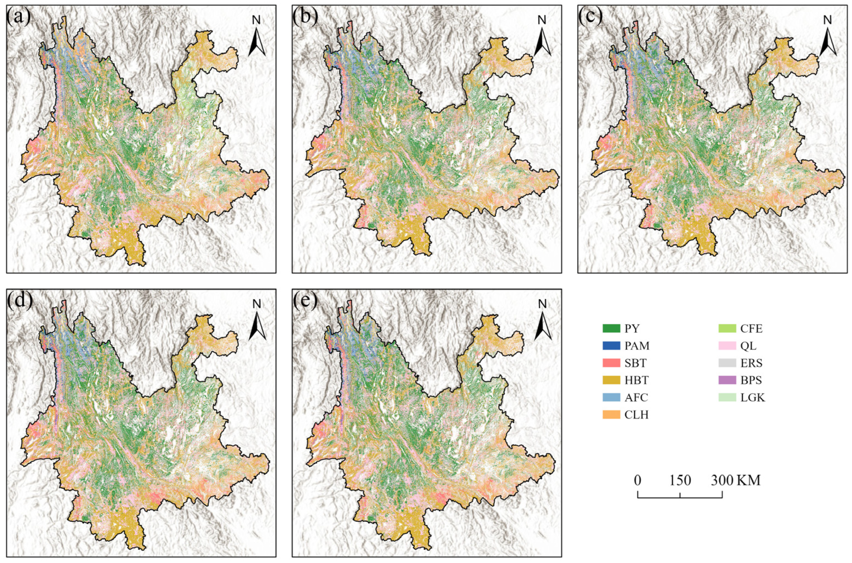
3.1.1. Spatial Distribution Patterns and Temporal Dynamics

Table 3 shows the dynamics of the carbon storage (CS) and carbon density (CD) of AM from 2016 to 2020. The results show that CS and CD remained relatively stable, with CS ranging from 54.37 to 55.76 Mt C and CD from 75.64 to 77.42 t C hm−2. In contrast, PA’s CS fluctuated, peaking at 30.45 Mt C in 2017 and dipping to 28.47 Mt C in 2018. The CD value followed a slightly different pattern, with a maximum of 93.90 t C hm−2 in 2016 and a minimum of 87.24 t C hm−2 in 2018. Both LM and CLH reached their highest CS in 2017 (4.80 Mt C and 25.22 Mt C, respectively), then declined in 2018 before gradually increasing. Their CD values also peaked in 2017 (70.10 t C hm−2 for LM; 38.67 t C hm−2 for CLH), but post-2017 trajectories diverged: LM’s CD fell and then slightly recovered by 2020, whereas CLH’s CD decreased steadily from 2018 onward. CL exhibited low CS and CD overall, with a slow year-on-year increase in CS and little change in CD. PYF maintained consistently high CS (ranging from 184.78 to 251.25 Mt C) and CD (26.52–30.00 t C hm−2) across the period. FD showed a gradual annual rise in CS, while its CD fluctuated moderately without a clear trend. BL displayed only minor year-to-year variations in both CS and CD. EL reached its lowest CS and CD in 2018 before rebounding thereafter. Finally, OSB and OHW experienced slight but limited fluctuations in CS and CD during the study period. These results underscore pronounced interspecific differences in carbon storage and density dynamics, as well as temporal variability, in the carbon sequestration capacities of individual tree species groups.

3.1.2. Prefectural Distribution Patterns and Temporal Changes

Table 4 indicates the pronounced spatial variability and temporal dynamics of arbor forest carbon storage in Yunnan Province from 2016 to 2020. Total provincial carbon storage increased steadily from 832.13 Mt C in 2016 to 938.84 Mt C in 2020—with an annual average of 892.16 Mt C—reflecting a stable upward trend. Spatially, Pu’er City (137.62 Mt C), Xishuangbanna Dai Autonomous Prefecture (103.72 Mt C), and Diqing Tibetan Autonomous Prefecture (97.96 Mt C) ranked highest in mean annual storage, collectively accounting for the majority of the province’s total. Pu’er City’s carbon storage rose consistently from 131.38 Mt C in 2016 to 142.08 Mt C in 2020, while Xishuangbanna Prefecture grew from 100.40 Mt C to 107.27 Mt C over the same period. Some prefectures fluctuated: Nujiang Lisu Autonomous Prefecture’s storage dropped sharply to 71.37 Mt C in 2017 before recovering to 81.21 Mt C by 2020, whereas Honghe Hani and Yi Autonomous Prefecture followed a generally upward but variable trajectory. In contrast, densely populated and economically developed regions—Zhaotong, Kunming, and Qujing Cities—recorded lower storage (annual averages of 23.46, 23.39, and 21.98 Mt C, respectively) with slower growth, suggesting trade-offs between development and conservation. Overall, Yunnan’s arbor forest carbon storage is highly heterogeneous: high-value zones concentrate in ecologically critical areas of southern (e.g., Xishuangbanna) and northwestern Yunnan (e.g., Diqing), while central urban agglomerations (e.g., Kunming) exhibit lower values. Although most prefectures showed upward trends, localized fluctuations underscore the need to monitor potential natural or anthropogenic disturbances affecting forest carbon sinks.
Figure 3 illustrates the temporal and spatial patterns of arbor forest carbon density in Yunnan Province from 2016 to 2020. The provincial average carbon density showed a modest upward trend, which increased from 41.92 to 42.32 t·C hm−2. Except for Qujing City, which recorded relatively low densities (18.57 t·C hm−2 in 2016; 19.41 t·C hm−2 in 2017; 18.72 t·C hm−2 in 2018), all prefectures maintained densities above 20 t·C hm−2 and peaked at approximately 79.96 t·C hm−2, underscoring the concentrated distribution of forest resources and the robust carbon sequestration capacity of arbor forests. Spatially, high-density zones clustered in the ecologically critical regions of northwestern and southern Yunnan. Nujiang Lisu Autonomous Prefecture exhibited the highest mean annual density (76.51 t·C hm−2) despite its limited forest area (1.0088 million hm2), whereas Pu’er City—ranked first in total carbon storage due to its substantially larger area (2.9301 million hm2)—had a lower mean density (46.98 t·C hm−2), reflecting an inverse relationship between area and density. Eastern and central regions (e.g., Kunming and Qujing) consistently fell below the provincial average, highlighting the effects of intensive human activity and complex topography. Notably, Chuxiong Yi Autonomous Prefecture achieved the highest province-wide growth rate in density, indicating enhanced sequestration efficiency through ecological restoration or optimized forest management. Xishuangbanna Dai Autonomous Prefecture and Diqing Tibetan Autonomous Prefecture maintained persistently high densities, demonstrating the effectiveness of conservation policies in sustaining carbon sinks. Generally, the spatial heterogeneity of arbor forest carbon density in Yunnan aligns closely with ecological priority zones, while low-density areas coincide with human-activity hotspots. Although the overall provincial trend stabilized, localized fluctuations (e.g., rapid growth in Chuxiong) call for differentiated management strategies to maximize carbon sink potential and support sustainable regional development.
Figure 4 highlights the marked spatial heterogeneity in arbor forest CS and CD across Yunnan Province, revealing clear regional contrasts. Notably, this figure presents prefecture-level aggregated statistics rather than interpolated surface data, with values derived from zonal statistics based on administrative boundaries. High-CS zones (88–142 Mt C) are concentrated in ecological barrier areas—southern Yunnan (Xishuangbanna Dai Autonomous Prefecture, Pu’er City) and northwestern Yunnan (Diqing Tibetan and Nujiang Lisu autonomous prefectures)—whereas central urban agglomerations (e.g., Kunming and Yuxi cities) exhibit lower CS (21–56 Mt C). Carbon density follows a similar pattern: high-density areas (62–85 t C hm−2) coincide with these critical ecological regions, while low-density zones (21–56 t C hm−2) occur predominantly in the human-activity-intensive central and eastern prefectures. Over the 2016–2020 period, provincial CS trends upward overall, though localized fluctuations also occurred: Chuxiong Yi Autonomous Prefecture experienced rapid CD increases—likely driven by ecological restoration projects—whereas Dehong Dai and Jingpo Autonomous Prefecture, Baoshan City, and parts of southeastern Yunnan saw periodic CS declines attributable to drought or forest land development.

3.2. Analysis of Carbon Storage Centroid Shifts

As shown in Figure 5, the SDE of arbor forest carbon storage in Yunnan Province retained a consistent shape and orientation from 2016 to 2020, with its azimuth shifting by just 1.12°. The centroid migrated eastward by a total of 4.8 km, with the greatest annual displacement of 1.67 km occurring between 2018 and 2019 and the smallest of 0.44 km between 2019 and 2020, reflecting gradual gains in eastern Yunnan’s carbon storage. Each ellipse displayed a clear northwest–southeast alignment of its major axis, mirroring the high-storage belts in southern Yunnan (Pu’er City, Xishuangbanna) and northwestern Yunnan (Nujiang, Diqing). Meanwhile, the minor axis (east–west) lengthened slightly from 216,784.39 m to 219,199.10 m, and the major axis (north–south) contracted from 312,901.15 m to 309,470.94 m. The overall decrease in the ellipse’s area and perimeter indicates a spatial contraction of carbon storage toward the provincial core along the northwest–southeast axis over the study period.

3.3. Analysis of Influencing Factors on Arbor Forest Carbon Storage in Yunnan Province

The relationship between arbor forest carbon storage in Yunnan Province’s prefectures (cities) and mean annual temperature (T), annual precipitation (P), elevation (H), per capita GDP (G), population density (R), and afforestation area (A) is described by the following equation:
C = 0.453 T + 0.31 P 0.433 H + 0.331 G 0.816 R A + 1.661
Table 5 demonstrates that the overall model is statistically significant (F = 14.215, p < 0.001), with an R2 of 0.539. The regression results indicate that the selected predictors explain 53.9% of the variance in arbor forest carbon storage across Yunnan Province. Among the natural factors, mean annual temperature (β = − 0.453, p < 0.001) and elevation (β = − 0.433, p < 0.001) both exerted significant negative effects, with temperature having the strongest influence, which reflects the critical regulatory role of Yunnan’s complex topography and vertical climate gradients on spatial carbon distribution. Precipitation (β = 0.310, p = 0.005) showed a significant positive effect, suggesting that favorable water–heat conditions enhance forest carbon sequestration capacity. Turning to socioeconomic drivers, per capita GDP (β = 0.331, p = 0.031) positively promotes carbon storage, likely due to the increased investment in environmental protection accompanying economic development. Notably, population density (β = − 0.816, p < 0.001) exhibits the strongest negative impact, underscoring the suppressive effect of human activity on forest carbon stocks. Although afforestation area has a large negative coefficient (β = − 1.000), it is not statistically significant (p = 0.364), perhaps reflecting a reduced need for new plantations as forest quality improved during the study period. All the variance inflation factors (VIFs) are below 8, indicating no serious multicollinearity among predictors. These findings systematically revealed the differentiated mechanisms by which natural and socioeconomic factors influence arbor forest carbon storage in Yunnan Province.

4. Discussion

4.1. Spatiotemporal Distribution of Carbon Storage and Carbon Density in Yunnan’s Arbor Forests

Between 2016 and 2020, arbor forest carbon storage in Yunnan Province exhibited a sustained upward trend, increasing from 832.13 Mt to 938.84 Mt, while carbon density rose modestly from 41.92 to 42.32 t C hm−2. These annual increases indicate a progressively enhanced carbon sequestration capacity within the province’s forest ecosystems. Spatially, the highest levels of carbon storage and carbon density were observed in Pu’er City, Xishuangbanna Dai Autonomous Prefecture, Diqing Tibetan Autonomous Prefecture, and Nujiang Lisu Autonomous Prefecture. This pattern can be attributed to their abundant forest resources, high canopy cover and quality, and favorable hydrothermal conditions. Conversely, Kunming, Qujing, and Zhaotong cities exhibited relatively lower carbon stocks and densities, primarily due to rapid urbanization and high population densities, which have contributed to the encroachment on forestland. Additionally, the karst terrain found in central and eastern Yunnan is characterized by a low ecological carrying capacity and limited productivity, further constraining regional carbon sequestration potential. These patterns align with the findings of Zhou et al. [30] and Wang et al. [31], who also documented a west–east gradient—higher values in western Yunnan and lower values in the east. These results underscore pronounced regional disparities in forest carbon dynamics and highlight the demand for location-specific management strategies.

4.2. Trends in the Spatial Centroid of Carbon Storage

From 2016 to 2020, the geographic center of arbor forest carbon storage in Yunnan Province migrated eastward by approximately 4.8 km. This shift corresponds closely to large-scale afforestation efforts in central and eastern regions of the province. According to provincial statistical yearbooks, the afforested area in these regions—particularly in Zhaotong City—increased significantly from 56,200 ha in 2017 to 84,000 ha in 2020. Enhanced afforestation has contributed to the expansion of forested land and the accumulation of carbon stocks, thereby driving the eastward movement of the carbon storage centroid. Consistent with previous findings, afforestation is reaffirmed as an effective approach for strengthening terrestrial carbon sinks, especially in regions with complex terrain and vulnerable ecological conditions, such as Yunnan. Su et al. [14] demonstrated that reforestation initiatives can substantially increase forest carbon stocks, reduce greenhouse gas emissions, and support climate change mitigation. Notably, as forest quantity and quality have continued to improve in afforested regions, this study identifies a negative correlation between carbon stock growth and the rate of new afforestation. This phenomenon may reflect a declining marginal carbon sequestration effect from newly established plantations, potentially due to the gradual maturation of forest stands and a reduced carbon accumulation potential per unit area. Some studies have indicated that plantations tend to exhibit higher carbon sequestration efficiency during early growth stages, whereas the rate of carbon accumulation stabilizes or even declines as stand age increases [32], thereby limiting the incremental gains in carbon stock from continued afforestation within a given region. Moreover, mature forests—characterized by structural stability, reduced photosynthetic efficiency, and intensified understory competition—may exhibit slower carbon accumulation rates, thus diminishing the marginal contribution of large-scale afforestation to total carbon sinks. This trend aligns with the findings of Cheng et al. [33] and Yu et al. [34], who emphasized that forest carbon stock dynamics are influenced, to a considerable extent, by forest age structure and may demonstrate attenuated responses as forest ecosystems transition from an expansion phase to a more stable state. Therefore, in assessing carbon sink dynamics at the regional scale, greater attention should be paid to forest age composition, silvicultural practices, and the temporal evolution of different stand types in shaping carbon accumulation outcomes.

4.3. Key Drivers of Carbon Storage Variation

Changes in arbor forest carbon storage in Yunnan are governed by a combination of natural and socioeconomic factors. Among natural variables, precipitation exerts a significant positive influence, as increased rainfall promotes vegetation growth, biomass accumulation, and carbon uptake. In contrast, temperature and elevation both have strong negative effects, with temperature exhibiting the most pronounced impact. High-temperature zones, characterized by elevated evapotranspiration and water deficits, tend to limit vegetative growth and reduce carbon storage—particularly in arid valley regions. Similarly, higher elevations with lower temperatures and less favorable hydrothermal conditions constrain biomass productivity. Among socioeconomic drivers, per capita GDP shows a positive correlation with carbon storage, likely reflecting stronger investment in forest conservation and management in economically developed areas. By contrast, population density and afforested area demonstrate negative associations with carbon stocks. High population densities are often linked to intensified forest resource consumption and anthropogenic disturbances, which inhibit carbon accumulation. Although total afforestation area slightly declined during the study period, forest quality improvements—driven by timber stand management, tending, and ecological restoration—reduced the need for new plantations, thereby contributing to the observed negative relationship. These findings are consistent with those of McIntyre et al. [35] and Deacon et al. [36], who highlighted population pressure and economic development as key determinants of forest carbon dynamics. Overall, the spatiotemporal patterns of arbor forest carbon storage in Yunnan are jointly shaped by environmental conditions and the region’s socioeconomic development trajectory.

4.4. Policy Recommendations and Regional Development Strategies

To enhance Yunnan’s forest carbon stocks and overall sequestration capacity, targeted ecological protection and restoration efforts are essential—particularly in the central and eastern karst regions, where ecological vulnerability is high. Precision interventions, such as reforesting degraded slopes, increasing biodiversity, and improving soil and water conservation, can significantly enhance both carbon storage and ecosystem resilience. In areas where afforestation has already expanded (e.g., central and eastern Yunnan), further optimization of tree species group selection and plantation design—favoring high-carbon-sequestration species groups adapted to local climatic and edaphic conditions—will help maximize carbon uptake. Conversely, in rapidly urbanizing areas such as Kunming and Qujing, it is critical to balance development and forest conservation through integrated land use planning and the strict enforcement of green space quotas to mitigate anthropogenic pressure on forest carbon sinks. Promoting low-carbon urban infrastructure and green building practices can also help reduce emissions and enhance urban ecosystem services. Policymakers are encouraged to adopt differentiated strategies tailored to regional carbon stock patterns, such as prioritizing conservation in high-carbon-value regions (e.g., southern and northwestern Yunnan), intensifying restoration and sustainable management in transitional zones (e.g., central and eastern Yunnan), and aligning all actions with national carbon peaking and carbon neutrality goals. To achieve these objectives and ensure long-term sustainability, increased investment, enhanced technical support, and robust monitoring frameworks—especially in ecologically sensitive areas—are urgently needed.

4.5. Limitations and Future Work

This study constructed an integrated framework combining forest inventory data, CBEF modeling, SDE spatial analysis, and MLR to explore the spatiotemporal dynamics and driving mechanisms of arbor forest carbon storage in Yunnan Province. While the research provides meaningful insights into regional carbon stock patterns, several limitations remain. First, the temporal scale of the analysis was limited to a relatively short five-year window (2016–2020). Although this period captures recent ecological transitions and afforestation trends, it is insufficient to assess the long-term stability of carbon sinks or to detect delayed responses to climate or policy interventions. Future work should incorporate longer time series to better capture interannual variability, extreme climate events, and the cumulative effects of afforestation, forest aging, and ecological restoration. Second, although the FMI data used in this study offer high thematic accuracy and consistent structure, the spatial resolution was aggregated to the prefectural level. This approach may mask fine-scale heterogeneity in carbon distribution, especially in areas with fragmented landscapes or diverse forest types. Incorporating finer-scale data—such as plot-level forest inventory or remote sensing-derived structure metrics (e.g., LiDAR)—would enable more localized assessments and spatially explicit decision support. Third, the statistical modeling approach based on MLR is effective for identifying key drivers, but it assumes linear relationships and does not fully account for interactions among variables or spatial dependence. To overcome this, future studies could integrate spatial regression models, nonlinear machine learning algorithms, or geographically weighted regression (GWR) to better capture complex and context-specific influences on carbon storage. Finally, the current analysis focused solely on the aboveground carbon stocks of arbor forests. However, carbon stored in belowground biomass and soil represents a significant portion of forest carbon pools and plays a critical role in ecosystem functioning. Future studies should adopt a full carbon accounting approach that includes all major carbon compartments, thereby enhancing the comprehensiveness and policy relevance of carbon assessments. Moreover, integrating carbon flux data (e.g., NEP, NBP) could support the dynamic modeling of carbon sequestration processes under future climate and land use scenarios.

5. Conclusions

Based on a systematic analysis of arbor forest carbon stocks in Yunnan Province from 2016 to 2020, this study draws the following key conclusions:
(1) Carbon storage exhibited a northwest–southwest high, eastern low spatial pattern, increasing from 832.13 Mt to 938.84 Mt, while carbon density rose from 41.92 to 42.32 t C·hm−2, indicating a continuous enhancement of forest carbon sequestration capacity.
(2) The spatial centroid of carbon storage migrated 4.8 km eastward, driven primarily by afforestation projects in central and eastern Yunnan, confirming the effectiveness of plantation efforts in augmenting regional carbon sinks.
(3) Driving factor analysis reveals that both natural and socioeconomic variables jointly regulate arbor forest carbon stocks: precipitation and economic development exert positive influences, whereas rising temperatures, higher elevations, and anthropogenic disturbances impose significant constraints. Notably, as ecosystem quality improves, the marginal need for new afforestation has declined.

Author Contributions

Conceptualization, J.W. (Jinxia Wu) and Y.C.; methodology, J.W. (Jinxia Wu) and Y.C.; validation, Q.W.; formal analysis, J.W. (Jinxia Wu) and Y.C.; investigation, W.Y.; resources, Q.W.; data curation, H.L. and M.L.; writing—original draft preparation, Y.C. and J.W. (Jinxia Wu); writing—review and editing, Y.C.; visualization, Y.H. and J.W. (Jingfei Wan); supervision, Q.W.; project administration, Q.W.; funding acquisition, Q.W. All authors have read and agreed to the published version of the manuscript.

Funding

This research was funded by research grants from the Yunnan Provincial Department of Science and Technology Science and Technology Program Project (202404CB090005).

Data Availability Statement

The original contributions presented in this study are included in the article. Further inquiries can be directed to the corresponding author.

Acknowledgments

We are grateful for the support of our colleagues from the Yunnan Institute of Forest Inventory and Planning who participated in the survey.

Conflicts of Interest

The authors declare no conflicts of interest.

References

  1. Fu, C.; Xu, M. Achieving Carbon Neutrality through Ecological Carbon Sinks: A Systems Perspective. Green. Carbon. 2023, 1, 43–46. [Google Scholar] [CrossRef]
  2. Piao, S.; Fang, J.; Ciais, P.; Peylin, P.; Huang, Y.; Sitch, S.; Wang, T. The Carbon Balance of Terrestrial Ecosystems in China. Nature 2009, 458, 1009–1013. [Google Scholar] [CrossRef] [PubMed]
  3. Raich, J.W.; Rastetter, E.B.; Melillo, J.M.; Kicklighter, D.W.; Steudler, P.A.; Peterson, B.J.; Grace, A.L.; Moore, B., III; Vorosmarty, C.J. Potential Net Primary Productivity in South America: Application of a Global Model. Ecol. Appl. 1991, 1, 399–429. [Google Scholar] [CrossRef]
  4. Yin, S.; Gong, Z.; Gu, L.; Deng, Y.; Niu, Y. Driving Forces of the Efficiency of Forest Carbon Sequestration Production: Spatial Panel Data from the National Forest Inventory in China. J. Clean. Prod. 2022, 330, 129776. [Google Scholar] [CrossRef]
  5. Khan, M.N.; Tan, Y.; Gul, A.A.; Abbas, S.; Wang, J. Forest Aboveground Biomass Estimation and Inventory: Evaluating Remote Sensing-Based Approaches. Forests 2024, 15, 1055. [Google Scholar] [CrossRef]
  6. Zheng, X.; Wang, H.; Dong, C.; Lou, X.; Wu, D.; Fang, L.; Dai, D.; Xu, L.; Xue, X. Tree Height Estimation of Chinese Fir Forests Based on Geographically Weighted Regression and Forest Survey Data. Forests 2024, 15, 1315. [Google Scholar] [CrossRef]
  7. Li, Q.; Xia, X.; Kou, X.; Niu, L.; Wan, F.; Zhu, J.; Xiao, W. Forest Carbon Storage and Carbon Sequestration Potential in Shaanxi Province, China. Forests 2023, 14, 2021. [Google Scholar] [CrossRef]
  8. Cheng, K.; Wu, J.; Ma, X.; Wu, L. Simulation of Carbon Sink of Arbor Forest Vegetation in Henan Province of China Based on CO2FIX Model. Land 2023, 12, 246. [Google Scholar] [CrossRef]
  9. Zhao, Z.; Tao, C.; Liu, X.; Cheng, X.; Zhou, C.; Huang, S.; Shou, M.; Zhang, Q.; Huang, B.; Li, C.; et al. Effects of Different Management Measures on Carbon Stocks and Soil Carbon Stocks in Moso Bamboo Forests: Meta-Analysis and Control Experiment. Forests 2024, 15, 496. [Google Scholar] [CrossRef]
  10. Sun, W.; Liu, X. Review on Carbon Storage Estimation of Forest Ecosystem and Applications in China. For. Ecosyst. 2019, 7, 4. [Google Scholar] [CrossRef]
  11. Huang, Z.; Liu, X.; Chu, H.; Jia, H.; He, X.; Wang, C.; Zhang, B.; Pan, C.; Liu, S.; Fan, S.; et al. The Impact of Nitrogen Addition on Soil Carbon Components and Understory Vegetation in Moso Bamboo Forests. Plants 2025, 14, 569. [Google Scholar] [CrossRef] [PubMed]
  12. Zhang, X.; Xu, X.; Li, X.; Cui, P.; Zheng, D. A New Scheme of Climate-Vegetation Regionalization in the Hengduan Mountains Region. Sci. China Earth Sci. 2024, 67, 751–768. [Google Scholar] [CrossRef]
  13. Xiahou, M.; Liu, Y.; Yang, T.; Shen, Z. Estimating Potential Vegetation Distribution and Restoration in a Biodiversity Hotspot Region under Future Climate Change. J. Geogr. Sci. 2024, 34, 2128–2144. [Google Scholar] [CrossRef]
  14. Su, J.; Long, Q.; Lin, S.; Hu, Z.; Zeng, Y. Carbon Neutralization in Yunnan: Harnessing the Power of Forests to Mitigate Carbon Emissions and Promote Sustainable Development in the Southwest Forest Area of China. Mitig. Adapt. Strat. Glob. Change 2024, 29, 87. [Google Scholar] [CrossRef]
  15. Lü, F.; Song, Y.; Yan, X. Evaluating Carbon Sink Potential of Forest Ecosystems under Different Climate Change Scenarios in Yunnan, Southwest China. Remote Sens. 2023, 15, 1442. [Google Scholar] [CrossRef]
  16. Cai, W.; Xu, L.; Li, M.; Li, O.J.; He, N. Imbalance of Inter-Provincial Forest Carbon Sequestration Rate from 2010 to 2060 in China and Its Regulation Strategy. J. Geogr. Sci. 2023, 33, 3–17. [Google Scholar] [CrossRef]
  17. Wang, R.; Zhao, J.; Lin, Y.; Chen, G.; Cao, Q.; Feng, Y. Land Change Simulation and Forest Carbon Storage of Central Yunnan Urban Agglomeration, China Based on SSP-RCP Scenarios. Forests 2022, 13, 2030. [Google Scholar] [CrossRef]
  18. Liu, S.; Ding, Z.; Lin, Y.; Yao, S. The Efficiency of Forest Management Investment in Key State-Owned Forest Regions under the Carbon Neutral Target: A Case Study of Heilongjiang Province, China. Forests 2022, 13, 609. [Google Scholar] [CrossRef]
  19. Zhou, J.; Zan, M.; Zhai, L.; Yang, S.; Xue, C.; Li, R.; Wang, X. Remote Sensing Estimation of Aboveground Biomass of Different Forest Types in Xinjiang Based on Machine Learning. Sci. Rep. 2025, 15, 6187. [Google Scholar] [CrossRef]
  20. Ogana, F.N.; Corey, G.P. Radtke Modeling the Growth and Yield of Natural Hardwood Stands in the Southern United States Using the Forest Inventory and Analysis Data. For. Ecol. Manag. 2025, 586, 122722. [Google Scholar] [CrossRef]
  21. Tapio, R. Comparative Analysis of Multiple Linear Regression and Random Forest Regression in Predicting Academic Performance of Students in Higher Education. Asian Res. J. Math. 2025, 21, 170–181. [Google Scholar] [CrossRef]
  22. Yan, W.; He, Y.; Cai, Y.; Qu, X.; Cui, X. Relationship between Extreme Climate Indices and Spatiotemporal Changes of Vegetation on Yunnan Plateau from 1982 to 2019. Glob. Ecol. Conserv. 2021, 31, e01813. [Google Scholar] [CrossRef]
  23. Gao, Z.; Sun, H.; Ou, X. The List of Natural Ecosystems in Yunnan, 2018 ed.; Yunnan Science and Technology Press: Kunming, China, 2023. [Google Scholar]
  24. Xie, B.; Jones, P.; Dwivedi, R.; Bao, L.; Liang, R. Evaluation, Comparison, and Unique Features of Ecological Security in Southwest China: A Case Study of Yunnan Province. Ecol. Indic. 2023, 153, 110453. [Google Scholar] [CrossRef]
  25. Liu, Z.; Peng, H. Notes on the Key Role of Stenochoric Endemic Plants in the Floristic Regionalization of Yunnan. Plant Divers. 2016, 38, 289–294. [Google Scholar] [CrossRef]
  26. Petersson, H.; Holm, S.; Ståhl, G.; Alger, D.; Fridman, J.; Lehtonen, A.; Lundström, A.; Mäkipää, R. Individual Tree Biomass Equations or Biomass Expansion Factors for Assessment of Carbon Stock Changes in Living Biomass—A Comparative Study. For. Ecol. Manag. 2012, 270, 78–84. [Google Scholar] [CrossRef]
  27. Parresol, B.R. Assessing Tree and Stand Biomass: A Review with Examples and Critical Comparisons. For. Sci. 1999, 45, 573–593. [Google Scholar] [CrossRef]
  28. Zhang, Y.; Jiang, P.; Cui, L.; Yang, Y.; Ma, Z.; Wang, Y.; Miao, D. Study on the Spatial Variation of China’s Territorial Ecological Space Based on the Standard Deviation Ellipse. Front. Environ. Sci. 2022, 10, 982734. [Google Scholar] [CrossRef]
  29. Epule, T.E. Forest Loss Triggers in Cameroon: A Quantitative Assessment Using Multiple Linear Regression Approach. J. Geogr. Geol. 2011, 3, 30. [Google Scholar] [CrossRef]
  30. Zhou, R.; Li, W.; Zhang, Y.; Peng, M.; Wang, C.; Sha, L.; Liu, Y.; Song, Q.; Fei, X.; Jin, Y.; et al. Responses of the Carbon Storage and Sequestration Potential of Forest Vegetation to Temperature Increases in Yunnan Province, SW China. Forests 2018, 9, 227. [Google Scholar] [CrossRef]
  31. Wang, Y.; Wang, M.; Zhang, J.; Wu, Y.; Zhou, Y. Assessment of Carbon Stocks and Influencing Factors in Terrestrial Ecosystems Based on Surface Area. iScience 2024, 27, 111431. [Google Scholar] [CrossRef]
  32. Wei, Y.; Li, M.; Chen, H.; Lewis, B.J.; Yu, D.; Zhou, L.; Zhou, W.; Fang, X.; Zhao, W.; Dai, L. Variation in Carbon Storage and Its Distribution by Stand Age and Forest Type in Boreal and Temperate Forests in Northeastern China. PLoS ONE 2013, 8, e72201. [Google Scholar] [CrossRef] [PubMed]
  33. Cheng, K.; Chen, Y.; Xiang, T.; Yang, H.; Liu, W.; Ren, Y.; Guan, H.; Hu, T.; Ma, Q.; Guo, Q. A 2020 Forest Age Map for China with 30 m Resolution. Earth Syst. Sci. Data 2024, 16, 803–819. [Google Scholar] [CrossRef]
  34. Yu, Z.; You, W.; Agathokleous, E.; Zhou, G.; Liu, S. Forest Management Required for Consistent Carbon Sink in China’s Forest Plantations. For. Ecosyst. 2021, 8, 54. [Google Scholar] [CrossRef]
  35. McIntyre, R.K.; McCall, B.B.; Wear, D.N. The Social and Economic Drivers of the Southeastern Forest Landscape. In Ecological Restoration and Management of Longleaf Pine Forests; CRC Press: Boca Raton, FL, USA, 2017; ISBN 978-1-315-15214-1. [Google Scholar]
  36. Deacon, R.T. Deforestation and Ownership: Evidence from Historical Accounts and Contemporary Data. Land Econ. 1999, 75, 341–359. [Google Scholar] [CrossRef]
Figure 1. Maps showing the location of the study area.
Forests 16 01076 g001
Figure 2. Forest resource distribution in Yunnan Province, 2016–2020. (a) 2016; (b) 2017; (c) 2018; (d) 2019; (e) 2020. AM (Abies Mill.), PA (Picea A. Dietrich), LM (Larix Mill.), CLH (Cunninghamia lanceolata (Lamb.) Hook.), CL (Cupressus L.), PYFF (Pinus yunnanensis Franch.), FD (Fagaceae Dumort.), BL (Betula L.), EL (Eucalyptus L. Herit), OSB (other soft and broad categories), OHW (other hard and wide categories).
Forests 16 01076 g002
Figure 3. Carbon density in Yunnan Province from 2016 to 2020.
Forests 16 01076 g003
Figure 4. Dynamic changes in the carbon storage and carbon density of arbor forests in Yunnan Province, 2016–2020. (a) 2016; (b) 2017; (c) 2018; (d) 2019; (e) 2020.
Forests 16 01076 g004
Figure 5. Standard deviational ellipses and centroid movements of arbor forest carbon storage spatial distribution in Yunnan Province, 2016–2020. (a) An enlarged view of the legend in panel (b), showing the color-coded centroid markers for each year and the corresponding standard deviational ellipse styles. (b) Annual centroids and standard deviational ellipses of arbor forest carbon storage spatial distribution in Yunnan Province. Each colored dot represents the centroid position of carbon storage for a given year, while the ellipses illustrate the spatial dispersion and directional trend for that year.
Forests 16 01076 g005
Table 1. Overview of data sources and characteristics used in the study (2016–2020).
Data TypeDescriptionTime Span/ResolutionSource
Forest Resource Vector DataVector-based forest resource data from the “One Map” Spatiotemporal Database, based on ZY-3 and GF-1 (2 m resolution), with subcompartment mapping. Forests classified into 11 dominant types.2016–2020/Polygon (min. unit: 0.067 ha)Yunnan Provincial Forest Resource “One Map” Database
Socioeconomic DataPrefecture-level per capita GDP, population density, and afforestation area. Used to reflect development, human pressure, and ecological investment.2016–2020/Prefecture-levelYunnan Statistical Yearbooks (https://stats.yn.gov.cn/List22.aspx, accessed on 2 May 2025)
Meteorological DataDaily mean/max temperature and precipitation, interpolated to 1 km raster grids using IDW, then aggregated to annual means by region.2016–2020/1 km rasterNOAA NCEI (https://www.ncei.noaa.gov, accessed on 2 May 2025)
Topographic DataElevation data from ASTER GDEM V3, used to compute mean elevation per prefecture as a terrain covariate.Static/30 m resolutionASTER GDEM (https://www.earthdata.nasa.gov, accessed on 2 May 2025)
Table 2. Biomass conversion and expansion factors and carbon content coefficients of dominant forest tree species groups.
Types of Dominant Tree Species GroupsabCF
AM4.10950.59760.4962
PA1.38790.71680.4931
LM0.69860.82620.4893
CLH0.57430.71200.4990
CL0.45451.53410.4847
PYF0.91580.65010.5075
FD0.71961.29480.4802
BL0.75071.01180.4872
EL0.33301.17400.4783
OSB0.34541.21300.4730
OHW0.65340.99200.4711
Note: Parameters a and b are used to convert stand volume to biomass for different tree species groups (or species), while CF represents the carbon content coefficient of a given tree species (or species groups).
Table 3. Temporal variations in the carbon storage and carbon density of dominant tree species groups in Yunnan Province, 2016–2020.
Dominant Tree Species Group Types20162017201820192020
CSCDCSCDCSCDCSCDCSCD
AM54.3775.6454.8576.4154.9376.8555.4677.0255.7677.42
PA30.1593.9030.4593.7028.4787.2429.4589.5429.5889.51
LM4.0059.164.8070.104.1560.354.1860.204.2160.77
CLH23.4536.3425.2238.6721.0730.1221.6629.7722.7828.25
CL2.7033.552.9836.273.0336.043.1035.763.5635.65
PYF184.7826.52223.9729.70237.0529.20243.7729.43251.2530.00
FD247.4656.45255.1157.89262.4957.49268.7757.71273.2156.76
BL10.3045.4312.8653.6512.9151.1013.1251.0414.4355.38
EL30.8253.5430.2252.2320.1138.9421.2239.9021.5939.97
OSB123.1542.38123.2840.57125.3635.04127.5534.90131.1634.48
OHW120.9846.59121.0346.26121.9141.37125.2641.53131.2941.19
Table 4. Changes in the carbon storage of arbor forests by prefecture and city in Yunnan Province.
NumberRegionCarbon Stock/Mt
20162017201820192020Average Value
Yunnan832.13884.78891.49913.54938.84892.16
1Pu’er131.38135.49138.85140.31142.08137.62
2Xishuangbanna100.40101.15104.54105.28107.27103.73
3Diqing91.98101.2696.6799.83100.0797.96
4Nujiang74.0171.3779.1980.1681.2177.19
5Linjcang52.9855.7757.9258.2360.1357.01
6Baoshan50.8756.9455.3955.5357.0855.16
7Honghe47.7650.4249.8750.8852.8650.36
8Dali43.1347.8047.7949.5254.0948.47
9Chuxiong43.9745.6747.5551.0152.9048.22
10Dehong56.4351.5341.7041.8844.9147.29
11Lijiang40.2345.1847.5648.1749.9346.21
12Wenshan26.6228.9628.9829.2130.1028.77
13Yuxi22.8124.7325.0126.5927.5525.34
14Zhaotong18.5521.5927.1024.8925.1923.46
15Kunming16.3524.8322.0626.5627.1323.39
16Qujing14.6622.0921.3125.4926.3421.98
Table 5. Coefficient of the multiple linear regression equation.
Independent VariableNormalization FactorPVIFFR2
Constant1.6610.101 14.2150.539
T−0.4530.1975.635
P0.3100.0052.567
H−0.4330.1517.668
G0.3310.0313.586
R−0.8160.0003.440
A−1.000.3641.912
Note: P represents the significance factor; VIF represents the variance expansion factor; F represents the F test parameter in the significance of the multiple linear regression equation. R2 represents the square of the correlation coefficient R, which determines the coefficient.
Disclaimer/Publisher’s Note: The statements, opinions and data contained in all publications are solely those of the individual author(s) and contributor(s) and not of MDPI and/or the editor(s). MDPI and/or the editor(s) disclaim responsibility for any injury to people or property resulting from any ideas, methods, instructions or products referred to in the content.

