
Urban Forest Microclimates and Their Response to Heat Waves—A Case Study for London

 , and
, and
Abstract
1. Introduction
2. Materials and Methods
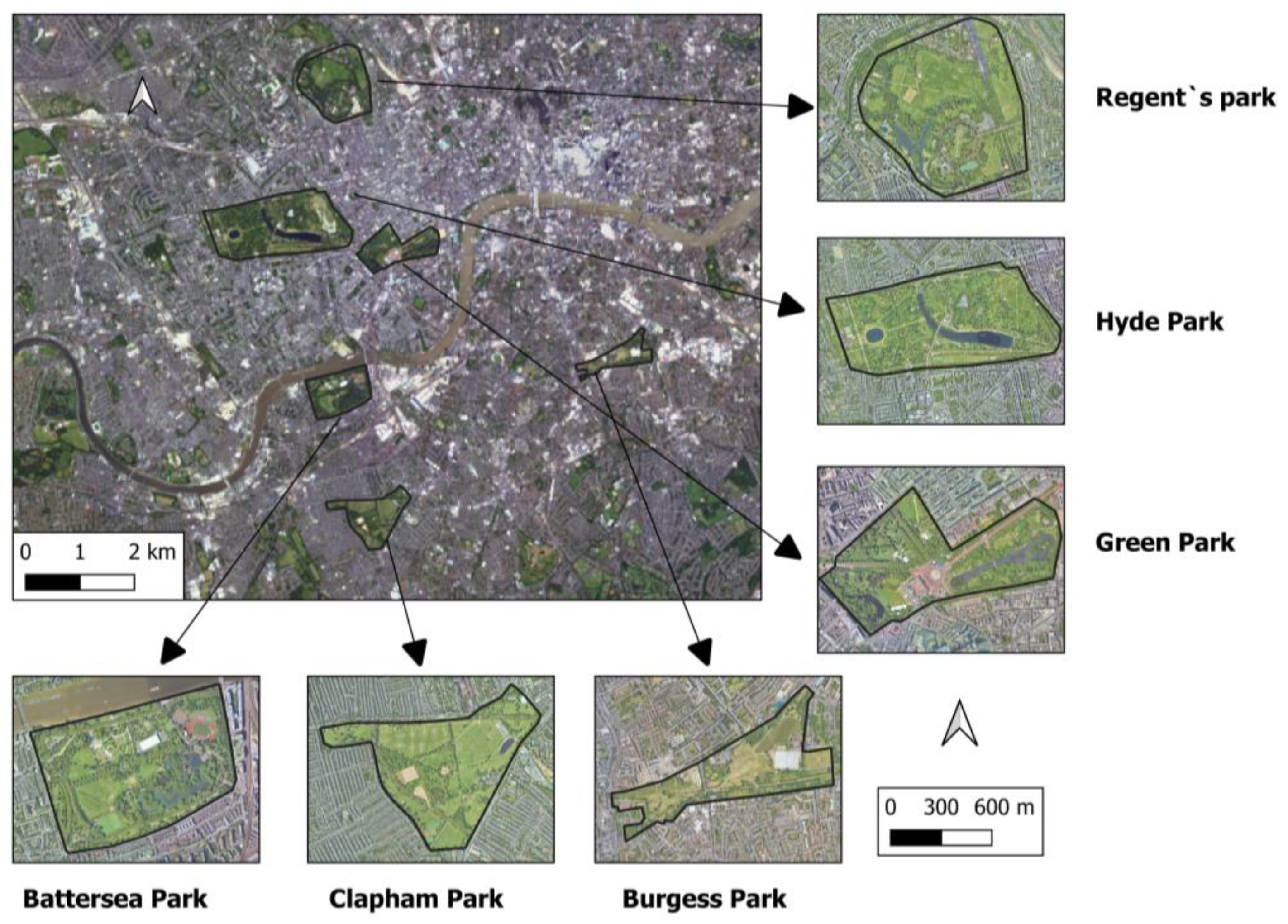
2.1. Study Area
2.2. Methodology
2.3. Landsat Images
2.4. Spectral Indices and LST Landsat
2.5. LULC
2.6. LSI
2.7. MTHI
2.8. Statistical Methodology
3. Results
3.1. LULC
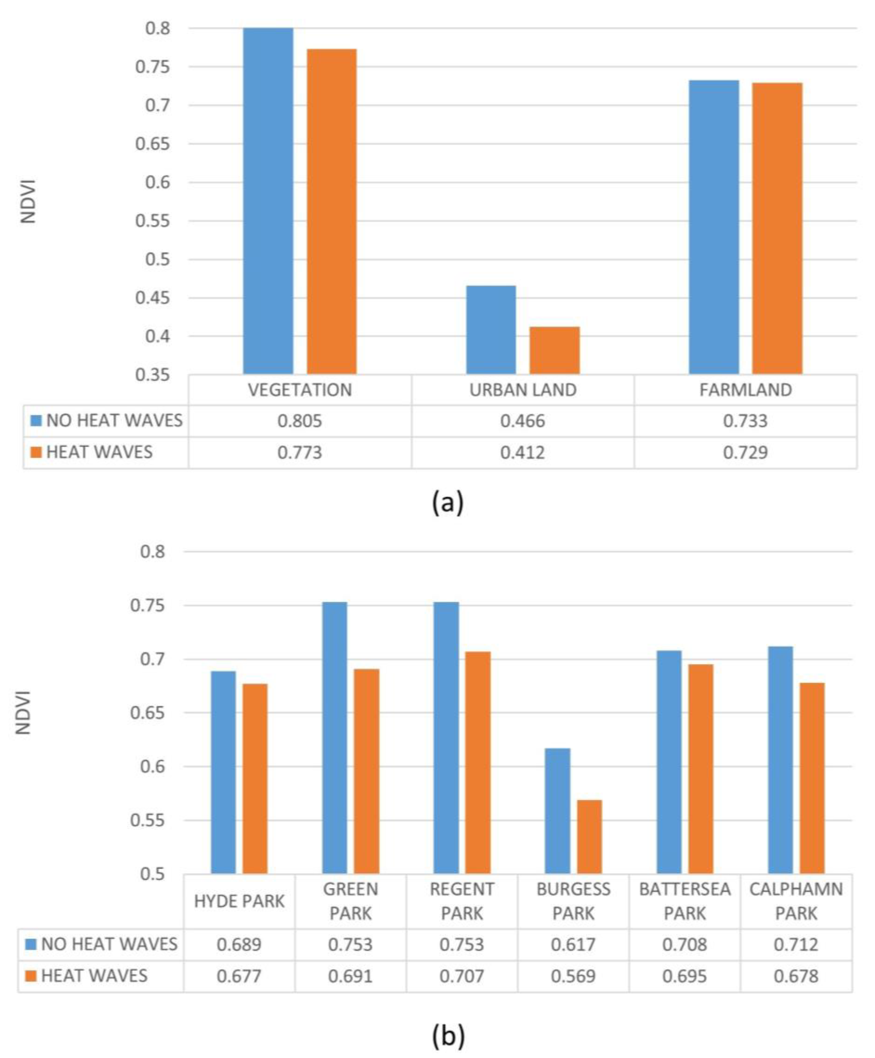
3.2. Spatiotemporal Evaluation of NDVI and NDMI
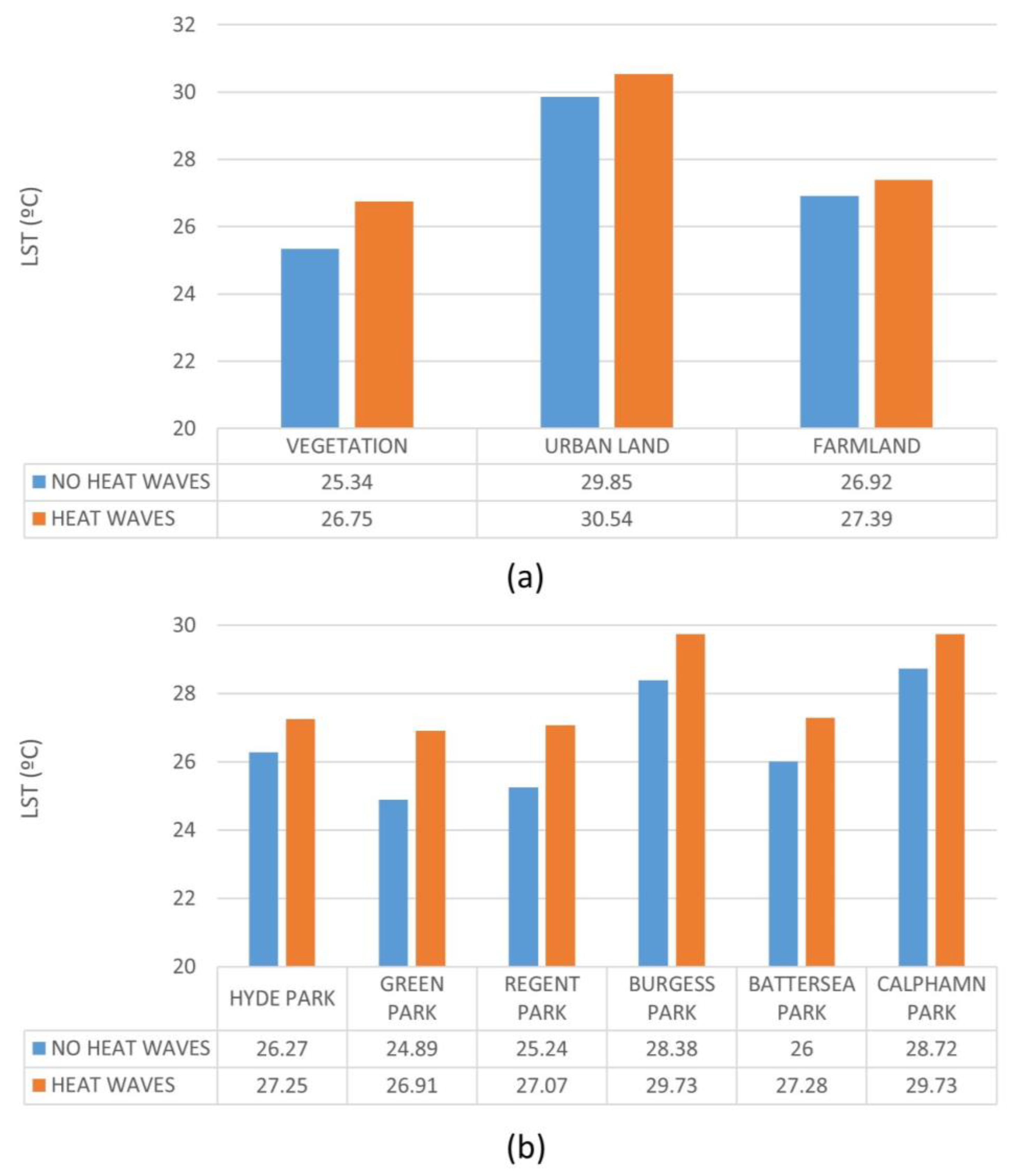
3.3. LST
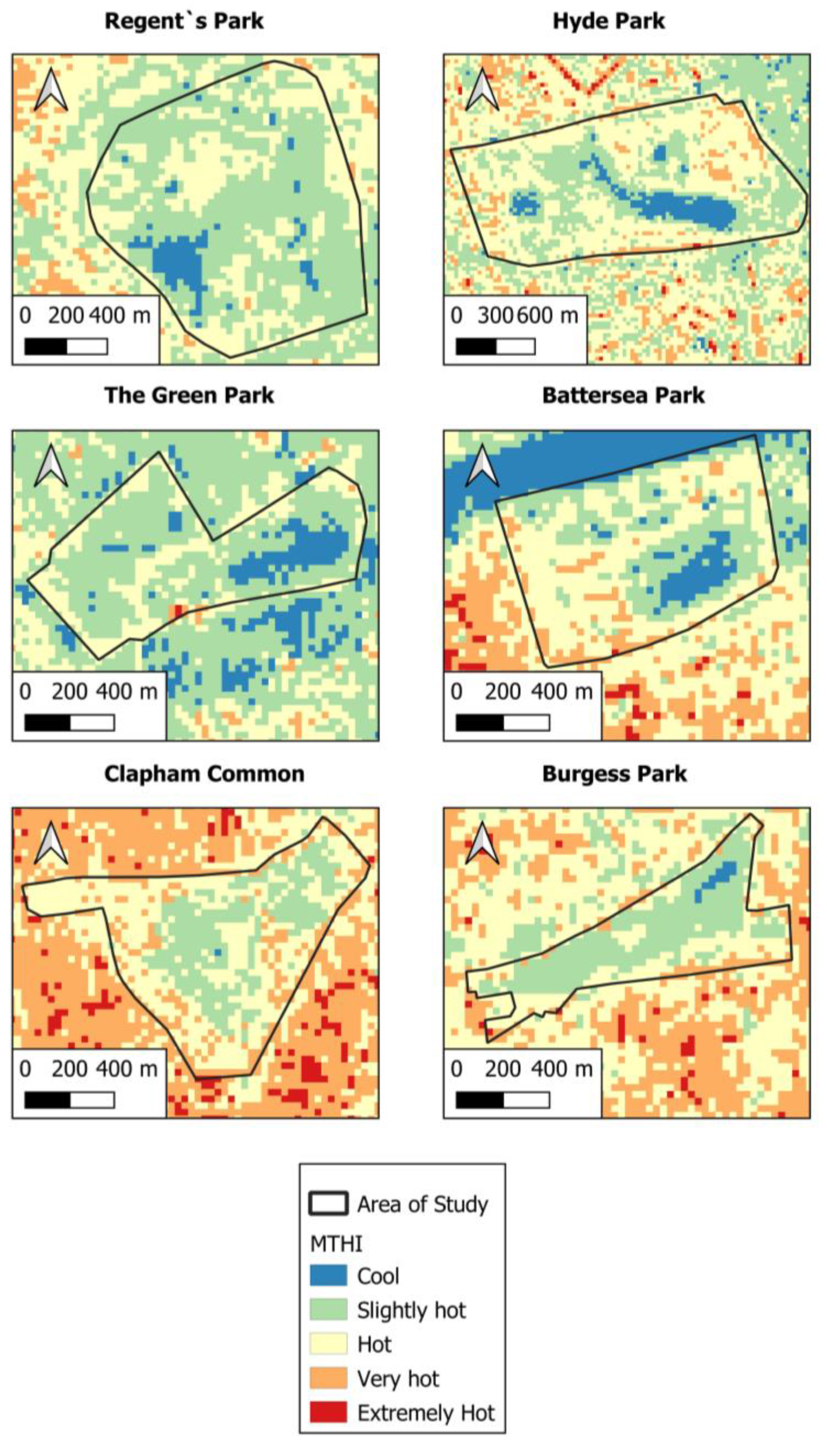
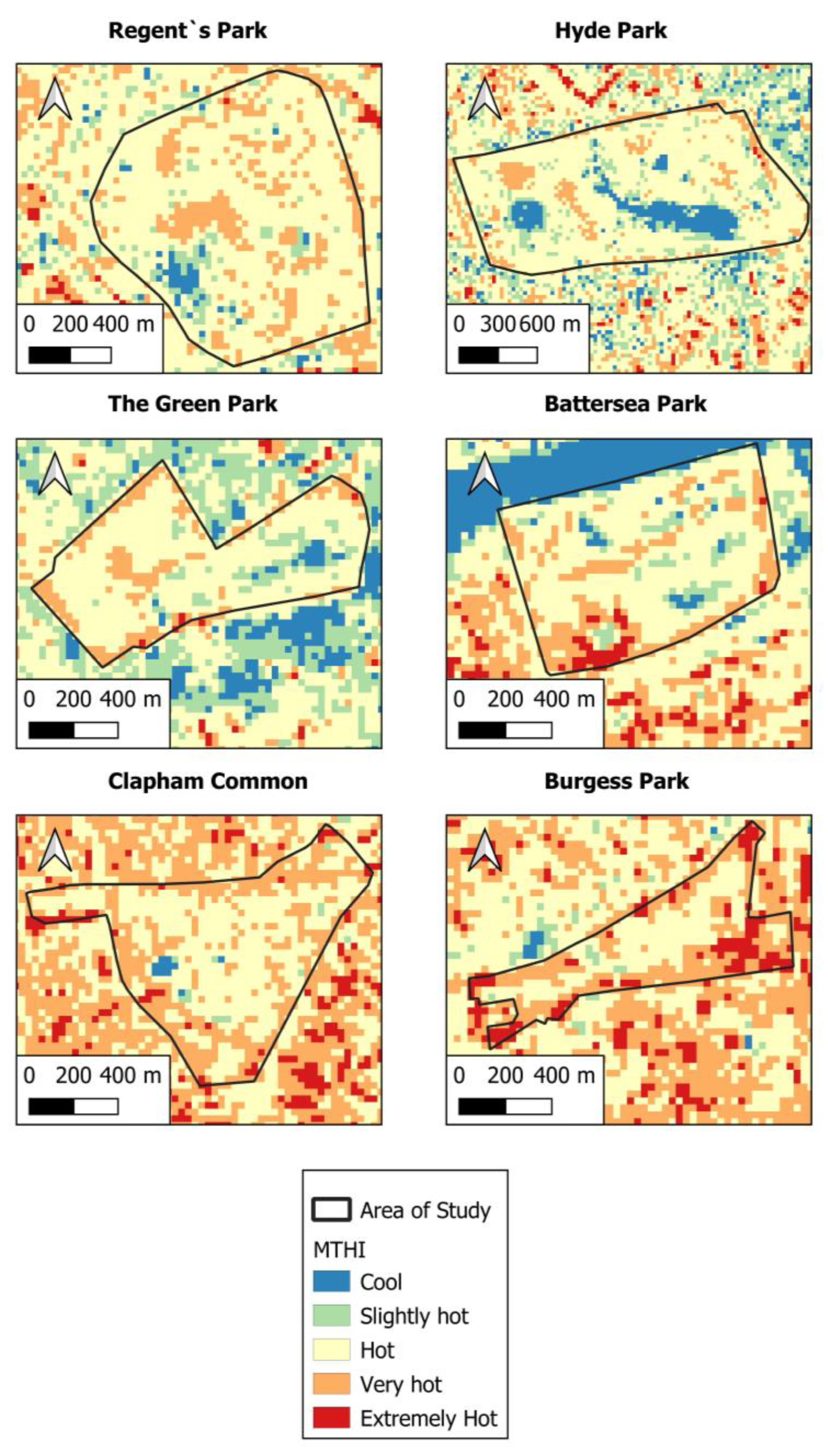
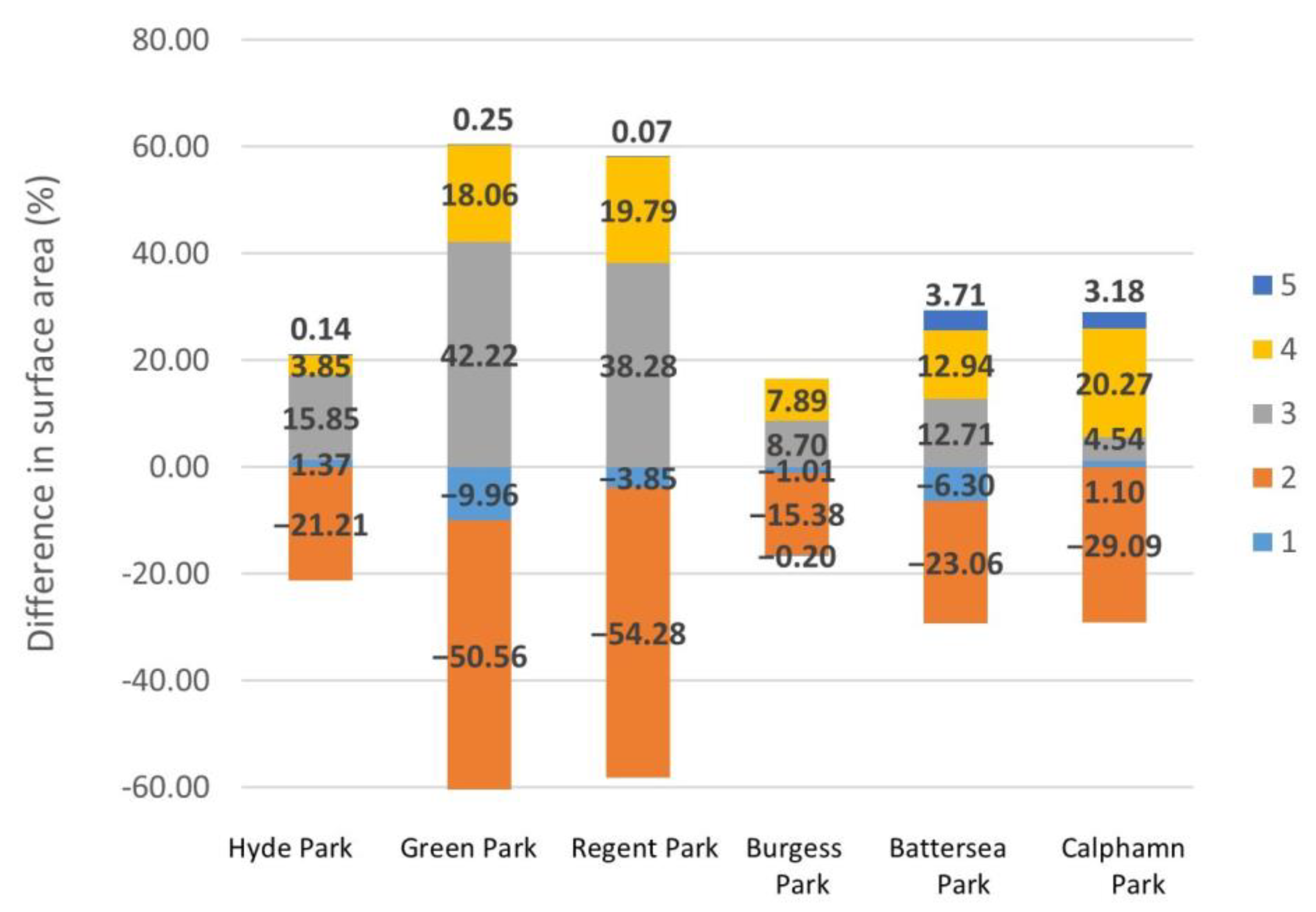
3.4. MTHI
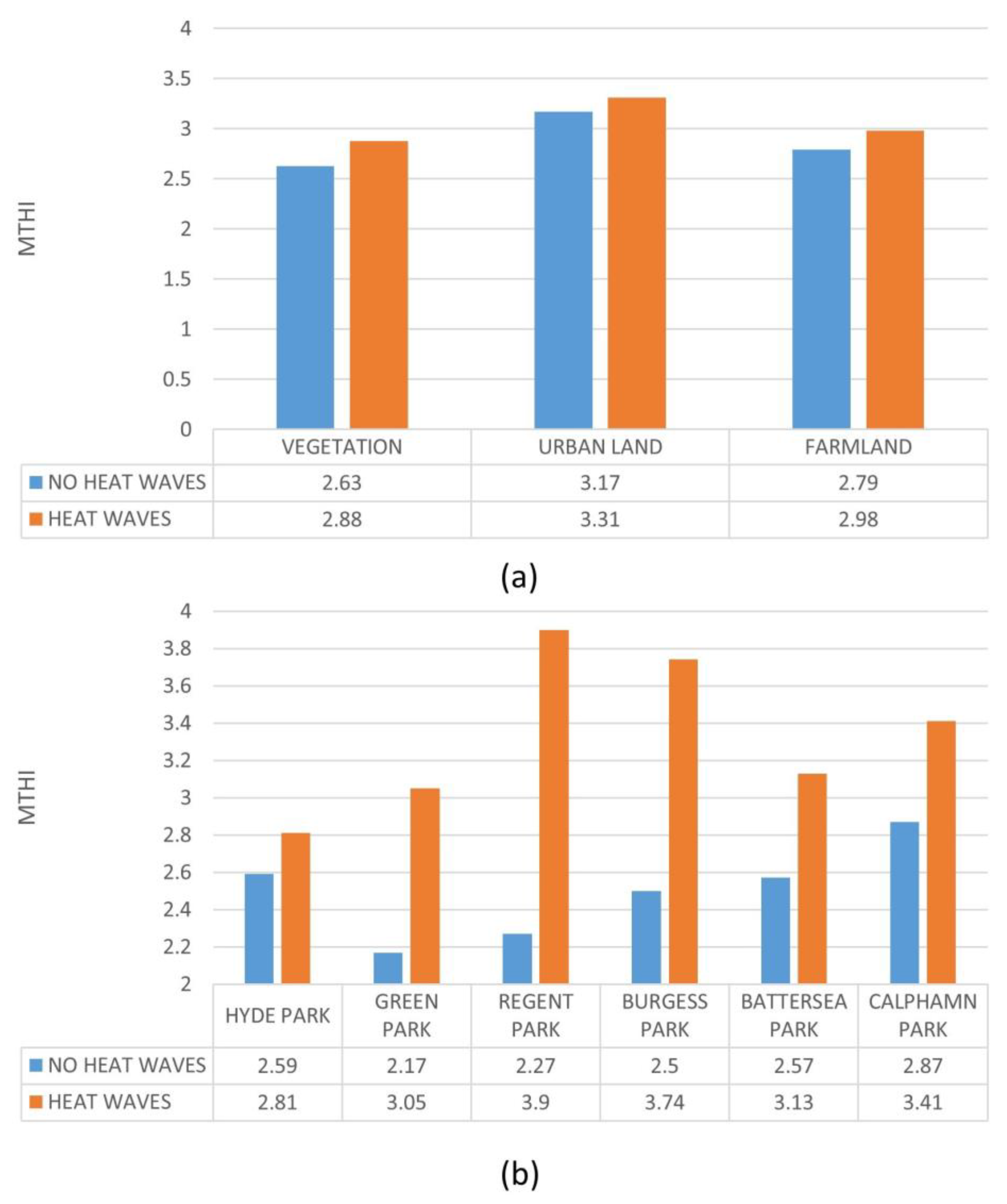
3.5. Statistical Analysis
3.5.1. ANOVA of Variables
3.5.2. Data Panel
4. Discussion
5. Conclusions
- Underscored the impact of elevated temperatures from heat waves on the thermal comfort of individuals in green spaces. This situation affects individuals and has future implications for these regions due to the anticipated rise in occurrences of extreme temperatures in the years to come.
- Investigated the environmental discomfort measured by the MTHI, which goes from 2.5 (slightly hot) to 3.34 (hot) in heat wave conditions. This indicates a substantial increase that considerably affects the environmental comfort of the people who visit these areas to alleviate the effects of high temperatures in urban areas.
- Reported that the promotion of green areas with trees and the use of BIs increase humidity and reduce temperatures, improving the thermal comfort of people who visit the place.
- Provided a key contribution to the effectiveness of green space temperature mitigation during heat waves in a city unfamiliar with these events.
- Offered a new methodology that allows for the analysis of comfort conditions in a way that can be easily extrapolated to other locations.
- Highlighted the importance of conducting additional studies that explore how climate change and heat waves will impact not only green areas but also the various activities that people carry out in them.
- Revealed the need to implement mitigation and resilience measures in both urban areas and green spaces.
- Suggested the urgent need to implement policies that prioritize climate resilience in green area planning. It is crucial to promote the development of green and blue infrastructure, as well as to increase the density of tree cover to improve thermal comfort and mitigate the effects of heat waves to make them more resilient to climate change. In this way, the integration of thermal comfort in the planning and management of spaces must be considered a fundamental element of public administration. In sum, the following actionable insights for policymakers are suggested:
- Increase tree density in urban green spaces: trees considerably lower temperatures and provide comfort during heat waves.
- Enhance tree coverage by choosing native and drought-resistant varieties.
- Preserve shade and evapotranspiration benefits by the regular maintenance of plants.
- Invest in green and blue infrastructure: such facilities reduce heat stress and promote climate resilience over time.
- Incorporate thermal comfort indices such as MTHI into urban planning to enhance the evaluation and design of public spaces that are appropriate for future climate conditions.
- Prioritize climatic adaptability when constructing ecological zones: cities must plan for increased frequency of heat waves and implement suitable measures.
- Identify sensitive areas and people: use geographical data to determine the areas where interventions such as planting and shade are most needed.
- Advocate for transdisciplinary urban climate research: policies should be based on robust and scalable methodologies and the results of scientific studies.
6. Limitations
Supplementary Materials
Author Contributions
Funding
Data Availability Statement
Conflicts of Interest
References
- Song, J.; Chen, W.; Zhang, J.; Huang, K.; Hou, B.; Prishchepov, A.V. Effects of building density on land surface temperature in China: Spatial patterns and determinants. Landsc. Urban Plan. 2020, 198, 103794. [Google Scholar] [CrossRef]
- MCGregor, G.R.; Felling, M.; Wolf, T.; Gosling, S. The Social Impacts of Heat Waves; Environment Agency: Bristol, UK, 2007; 41p. [Google Scholar]
- Lemonsu, A.; Viguié, V.; Daniel, M.; Masson, V. Vulnerability to heat waves: Impact of urban expansion scenarios on urban heat island and heat stress in Paris (France). Urban Clim. 2015, 14, 586–605. [Google Scholar] [CrossRef]
- Li, D.; Bou-Zeid, E. Synergistic interactions between urban heat islands and heat waves: The impact in cities is larger than the sum of its parts. J. Appl. Meteorol. Climatol. 2013, 52, 2051–2064. [Google Scholar] [CrossRef]
- Li, J.; Song, C.; Cao, L.; Zhu, F.; Meng, X.; Wu, J. Impacts of landscape structure on surface urban heat islands: A case study of Shanghai, China. Remote Sens. Environ. 2011, 115, 3249–3263. [Google Scholar] [CrossRef]
- Hidalgo García, D.; Arco Díaz, J. Modeling of the Urban Heat Island on local climatic zones of a city using Sentinel 3 images: Urban determining factors. Urban Clim. 2021, 37, 100840. [Google Scholar] [CrossRef]
- Stewart, I.D.; Oke, T.R. Local climate zones for urban temperature studies. Bull. Am. Meteorol. Soc. 2012, 93, 1879–1900. [Google Scholar] [CrossRef]
- Arnfield, A.J. Two decades of urban climate research: A review of turbulence, exchanges of energy and water, and the urban heat island. Int. J. Climatol. 2003, 23, 1–26. [Google Scholar] [CrossRef]
- Hidalgo, D. Analysis of synergies between the Urban Heat Island and Heat Waves using Sentinel 3 satellite images: Study of Andalusian cities (Spain). Earth Syst. Environ. 2021, 6, 199–219. [Google Scholar] [CrossRef]
- ONU. Una Población en Crecimiento. 2020. Available online: https://www.un.org/es/global-issues/population (accessed on 7 May 2025).
- Mukherjee, F.; Singh, D. Assessing Land Use–Land Cover Change and Its Impact on Land Surface Temperature Using LANDSAT Data: A Comparison of Two Urban Areas in India. Earth Syst. Environ. 2020, 4, 385–407. [Google Scholar] [CrossRef]
- Guo, A.; Yang, J.; Xiao, X.; Xia, J.; Jin, C.; Li, X. Influences of urban spatial form on urban heat island effects at the community level in China. Sustain. Cities Soc. 2020, 53, 101972. [Google Scholar] [CrossRef]
- Hidalgo García, D.; Rezapouraghdam, H. Climate change, heat stress and the analysis of its space-time variability in european metropolises. J. Clean. Prod. 2023, 425, 138892. [Google Scholar] [CrossRef]
- Karakuş, C.B. The Impact of Land Use/Land Cover (LULC) Changes on Land Surface Temperature in Sivas City Center and Its Surroundings and Assessment of Urban Heat Island. Asia Pac. J. Atmos. Sci. 2019, 55, 669–684. [Google Scholar] [CrossRef]
- Santamouris, M. Recent progress on urban overheating and heat island research. Integrated assessment of the energy, environmental, vulnerability and health impact. Synergies with the global climate change. Energy Build. 2020, 207, 109482. [Google Scholar] [CrossRef]
- Mora, C.; Dousset, B.; Caldwell, I.R.; Powell, F.E.; Geronimo, R.C.; Bielecki, C.R.; Counsell, C.W.; Dietrich, B.S.; Johnston, E.T.; Louis, L.V.; et al. Global risk of deadly heat. Nat. Clim. Change 2017, 7, 501–506. [Google Scholar] [CrossRef]
- Meehl, G.A.; Tebaldi, C. More intense, more frequent, and longer lasting heat waves in the 21st century. Science 2004, 305, 994–997. [Google Scholar] [CrossRef]
- Sun, Y.; Zhang, X.; Zwiers, F.W.; Song, L.; Wan, H.; Hu, T.; Yin, H.; Ren, G. Rapid increase in the risk of extreme summer heat in Eastern China. Nat. Clim. Change 2014, 4, 1082–1085. [Google Scholar] [CrossRef]
- An, N.; Dou, J.; González-Cruz, J.E.; Bornstein, R.D.; Miao, S.; Li, L. An observational case study of synergies between an intense heat wave and the urban heat island in Beijing. J. Appl. Meteorol. Climatol. 2020, 59, 605–620. [Google Scholar] [CrossRef]
- Coumou, D.; Robinson, A.; Rahmstorf, S. Global increase in record-breaking monthly-mean temperatures. Clim. Change 2013, 118, 771–782. [Google Scholar] [CrossRef]
- Saaroni, H.; Amorim, J.H.; Hiemstra, J.A.; Pearlmutter, D. Urban Green Infrastructure as a tool for urban heat mitigation: Survey of research methodologies and findings across different climatic regions. Urban Clim. 2018, 24, 94–110. [Google Scholar] [CrossRef]
- Hidalgo García, D. Spatio-temporal analysis of the urban green infrastructure of the city of Granada (Spain) as a heat mitigation measure using high-resolution images Sentinel 3. Urban For. Urban Green. 2023, 87, 128061. [Google Scholar] [CrossRef]
- Gago, E.J.; Roldan, J.; Pacheco-Torres, R.; Ordóñez, J. The city and urban heat islands: A review of strategies to mitigate adverse effects. Renew. Sustain. Energy Rev. 2013, 25, 749–758. [Google Scholar] [CrossRef]
- Solecki, W.D.; Rosenzweig, C.; Parshall, L.; Pope, G.; Clark, M.; Cox, J.; Wiencke, M. Mitigation of the heat island effect in urban New Jersey. Environ. Hazards 2005, 6, 39–49. [Google Scholar] [CrossRef]
- Oliveira, A.; Lopes, A.; Niza, S. Local climate zones in five southern European cities: An improved GIS-based classification method based on Copernicus data. Urban Clim. 2020, 33, 100631. [Google Scholar] [CrossRef]
- Dwivedi, A.; Mohan, B.K. Impact of green roof on micro climate to reduce Urban Heat Island. Remote Sens. Appl. 2018, 10, 56–69. [Google Scholar] [CrossRef]
- Masoudi, M.; Tan, P.Y.; Fadaei, M. The effects of land use on spatial pattern of urban green spaces and their cooling ability. Urban Clim. 2021, 35, 100743. [Google Scholar] [CrossRef]
- Qiu, G.Y.; Zou, Z.; Li, X.; Li, H.; Guo, Q.; Yan, C.; Tan, S. Experimental studies on the effects of green space and evapotranspiration on urban heat island in a subtropical megacity in China. Habitat. Int. 2017, 68, 30–42. [Google Scholar] [CrossRef]
- Yoshida, A.; Hisabayashi, T.; Kashihara, K.; Kinoshita, S.; Hashida, S. Evaluation of effect of tree canopy on thermal environment, thermal sensation, and mental state. Urban. Clim. 2015, 14, 240–250. [Google Scholar] [CrossRef]
- Spronken-Smith, R.A.; Oke, T.R. The thermal regime of urban parks in two cities with different summer climates. Int. J. Remote Sens. 1998, 19, 2085–2104. [Google Scholar] [CrossRef]
- Met Office. Summer 2022: A Historic Season for Northern Hemisphere Heat Waves. 2022. Available online: https://www.metoffice.gov.uk/blog/2022/summer-2022-a-historic-season-for-northern-hemisphere-heatwaves (accessed on 7 May 2025).
- Yang, L.; Yang, C.; Zhou, W.; Chen, X.; Wang, C.; Liu, L. Mapping the Spatial and Seasonal Details of Heat Health Risks in Different Local Climate Zones: A Case Study of Shanghai, China. Remote Sens. 2024, 16, 3513. [Google Scholar] [CrossRef]
- Feng, L.; Zhao, M.; Zhou, Y.; Zhu, L.; Tian, H. The seasonal and annual impacts of landscape patterns on the urban thermal comfort using Landsat. Ecol. Indic. 2020, 110, 105798. [Google Scholar] [CrossRef]
- Met Office. Unprecedented Extreme Heat Wave, July 2022. 2022. Available online: https://www.metoffice.gov.uk/binaries/content/assets/metofficegovuk/pdf/weather/learn-about/uk-past-events/interesting/2022/2022_03_july_heatwave_v1.pdf (accessed on 7 May 2025).
- Howarth, C.; Mcloughlin, N.; Armstrong, A.; Murtagh, E.; Mehryar, S.; Beswick, A.; Ward, B.; Ravishankar, S.; Stuart-Watt, A. Turning up the Heat Learning from the Summer 2022 Heat Waves in England to Inform UK Policy on Extreme Heat Evidence Report; Grantham Research Institute on Climate Change and the Environment, London School of Economics and Political Science: London, UK, 2024; Available online: www.lse.ac.uk/granthaminstitute (accessed on 7 May 2025).
- Hidalgo-García, D.; Arco-Díaz, J. Modeling the Surface Urban Heat Island (SUHI) to study of its relationship with variations in the thermal field and with the indices of land use in the metropolitan area of Granada (Spain). Sustain. Cities Soc. 2022, 87, 104166. [Google Scholar] [CrossRef]
- Yoo, C.; Han, D.; Im, J.; Bechtel, B. Comparison between convolutional neural networks and random forest for local climate zone classification in mega urban areas using Landsat images. ISPRS J. Photogramm. Remote Sens. 2019, 157, 155–170. [Google Scholar] [CrossRef]
- Chavez, P.S. An improved dark-object subtraction technique for atmospheric scattering correction of multispectral data. Remote Sens. Environ. 1988, 24, 459–479. [Google Scholar] [CrossRef]
- García, D.H.; Díaz, J.A. Spatial and multi-temporal analysis of land surface temperature through landsat 8 images: Comparison of algorithms in a highly polluted city (Granada). Remote Sens. 2021, 13, 1012. [Google Scholar] [CrossRef]
- Congedo, L. Semi-Automatic Classification Plugin Documentation Release 4.8.0.1. Release 2016, 4, 29. Available online: https://media.readthedocs.org/pdf/semiautomaticclassificationmanual-v4/latest/semiautomaticclassificationmanual-v4.pdf (accessed on 7 May 2025).
- García, D.H.; Díaz, J.A. Space–time analysis of the earth’s surface temperature, surface urban heat island and urban hotspot: Relationships with variation of the thermal field in Andalusia (Spain). Urban Ecosyst. 2023, 26, 525–546. [Google Scholar] [CrossRef]
- Yu, X.; Guo, X.; Wu, Z. Land surface temperature retrieval from landsat 8 TIRS-comparison between radiative transfer equation-based method, split window algorithm and single channel method. Remote Sens. 2014, 6, 9829–9852. [Google Scholar] [CrossRef]
- Kafer, P.S.; Rolim, S.B.A.; Iglesias, M.L.; Da Rocha, N.S.; Diaz, L.R. Land surface temperature retrieval by landsat 8 thermal band: Applications of laboratory and field measurements. IEEE J. Sel. Top. Appl. Earth Obs. Remote Sens. 2019, 12, 2332–2341. [Google Scholar] [CrossRef]
- Weng, Q.; Lu, D.; Schubring, J. Estimation of land surface temperature-vegetation abundance relationship for urban heat island studies. Remote Sens. Environ. 2004, 89, 467–483. [Google Scholar] [CrossRef]
- Sharma, R.; Pradhan, L.; Kumari, M.; Bhattacharya, P. Assessing urban heat islands and thermal comfort in Noida City using geospatial technology. Urban. Clim. 2021, 35, 100751. [Google Scholar] [CrossRef]
- Shafri, H.Z.M.; Ramle, F.S.H. A Comparison of Support Vector Machine and Decision Tree Classifications Using Satellite Data of Langkawi Island. Inf. Technol. J. 2009, 8, 64–70. [Google Scholar] [CrossRef]
- Otukei, J.R.; Blaschke, T. Land cover change assessment using decision trees, support vector machines and maximum likelihood classification algorithms. Int. J. Appl. Earth Obs. Geoinf. 2010, 12, S27–S31. [Google Scholar] [CrossRef]
- Amindin, A.; Pouyan, S.; Pourghasemi, H.R.; Yousefi, S.; Tiefenbacher, J.P. Spatial and temporal analysis of urban heat island using Landsat satellite images. Environ. Sci. Pollut. Res. 2021, 28, 41439–41450. [Google Scholar] [CrossRef]
- Wu, P.; Yin, Z.; Yang, H.; Wu, Y.; Ma, X. Reconstructing geostationary satellite land surface temperature imagery based on a multiscale feature connected convolutional neural network. Remote Sens. 2019, 11, 300. [Google Scholar] [CrossRef]
- Alcock, I.; White, M.P.; Lovell, R.; Higgins, S.L.; Osborne, N.J.; Husk, K.; Wheeler, B.W. What accounts for “England’s green and pleasant land”? A panel data analysis of mental health and land cover types in rural England. Landsc. Urban Plan. 2015, 142, 38–46. [Google Scholar] [CrossRef]
- Meng, X.; Cheng, J.; Zhao, S.; Liu, S.; Yao, Y. Estimating land surface temperature from Landsat-8 data using the NOAA JPSS enterprise algorithm. Remote Sens. 2019, 11, 155. [Google Scholar] [CrossRef]
- Fang, L.; Tian, C. Construction land quotas as a tool for managing urban expansion. Landsc. Urban Plan. 2020, 195, 103727. [Google Scholar] [CrossRef]
- Sarrat, C.; Lemonsu, A.; Masson, V.; Guedalia, D. Impact of urban heat island on regional atmospheric pollution. Atmos. Environ. 2006, 40, 1743–1758. [Google Scholar] [CrossRef]
- Du, J.; Xiang, X.; Zhao, B.; Zhou, H. Impact of urban expansion on land surface temperature in Fuzhou, China using Landsat imagery. Sustain. Cities Soc. 2020, 61, 102346. [Google Scholar] [CrossRef]
- Feizizadeh, B.; Blaschke, T. Examining Urban heat Island relations to land use and air pollution: Multiple endmember spectral mixture analysis for thermal remote sensing. IEEE J. Sel. Top. Appl. Earth Obs. Remote Sens. 2013, 6, 1749–1756. [Google Scholar] [CrossRef]
- Christidis, N.; McCarthy, M.; Stott, P.A. The increasing likelihood of temperatures above 30 to 40 °C in the United Kingdom. Nat. Commun. 2020, 11, 3093. [Google Scholar] [CrossRef] [PubMed]
- Hidalgo García, D.; Arco Díaz, J.; Martín Martín, A.; Gómez Cobos, E. Spatiotemporal Analysis of Urban Thermal Effects Caused by Heat Waves through Remote Sensing. Sustainability 2022, 14, 12262. [Google Scholar] [CrossRef]
- Brown, R.D.; Vanos, J.; Kenny, N.; Lenzholzer, S. Designing urban parks that ameliorate the effects of climate change. Landsc. Urban Plan. 2015, 138, 118–131. [Google Scholar] [CrossRef]
- Cheng, Y.; Bartesaghi-Koc, C.; Tian, Y.; Shen, L.; Teng, M.; Liu, H.; Xiao, Z.; Zhang, B.; Wu, C. Where and how to cool through blue infrastructure? Large lake groups to ameliorate urban overheating in a typical inland multi-lake megacity. Sustain. Cities Soc. 2023, 98, 104869. [Google Scholar] [CrossRef]
- Lin, Y.; Wang, Z.; Jim, C.Y.; Li, J.; Deng, J.; Liu, J. Water as an urban heat sink: Blue infrastructure alleviates urban heat island effect in mega-city agglomeration. J. Clean. Prod. 2020, 262, 121411. [Google Scholar] [CrossRef]
- Chun, B.; Guldmann, J.M. Spatial statistical analysis and simulation of the urban heat island in high-density central cities. Landsc. Urban Plan. 2014, 125, 76–88. [Google Scholar] [CrossRef]
- Puga-Bonilla, M.; Hidalgo-García, D.; Rezapouraghdam, H.; Bolivar, F.J.L. Risk of mortality and disease attributable to the heat stress index and its variability during heat waves: An observational study on the city of Madrid. Sustain. Cities Soc. 2025, 121, 106189. [Google Scholar] [CrossRef]
- Hidalgo-García, D.; Founda, D.; Rezapouraghdam, H. Spatiotemporal variability of the Universal Thermal Climate Index during heat waves using the UrbClim climate model: Implications for tourism destinations. Urban Clim. 2025, 59, 102281. [Google Scholar] [CrossRef]
- Rezapouraghdam, H.; Hidalgo-García, D. Urban Development and Climate Change: Implications for Educational Tourism Destination Planning. Water Air Soil. Pollut. 2024, 235, 319. [Google Scholar] [CrossRef]


| Area | Name | Surface Area (Ha) | Perimeter (m) | LSI | Aquatic Area (Ha) | Soil Type | Ground Cover |
|---|---|---|---|---|---|---|---|
| 1 | Regent’s Park | 138.69 | 4407 | 1.055 | 5.04 | Vegetation | 1 |
| 2 | Hyde Park | 250.91 | 5759 | 1.207 | 10.80 | Vegetation | 1 |
| 3 | Green Park | 72.74 | 4231 | 1.401 | 7.02 | Vegetation | 1 |
| 4 | Battersea Park | 80.67 | 3602 | 1.131 | 5.40 | Vegetation | 1 |
| 5 | Clapham Park | 81.91 | 4443 | 0.985 | 1.80 | Vegetation | 1 |
| 6 | Burgess Park | 45.40 | 4346 | 1.382 | 3.50 | Vegetation | 1 |
| Products | Environmental Condition | Date (yyyymmdd) | UTC Time (hhmm) | Cloud Cover (%) |
|---|---|---|---|---|
| LC08_L1TP_201024_20220710_T1 | No Heat Wave | 20220710 | 10:50 | 4.76 |
| LC09_L2SP_201024_20220718_T1 | Heat Wave | 20220718 | 10:48 | 0.38 |
| Index | Equation | Number | Reference |
|---|---|---|---|
| NDVI | (1) | [41] | |
| NDMI | (2) | [42] | |
| Spectral Radiance | (3) | [43] | |
| Brightness Temperature (°C) | (4) | [44] | |
| Land Surface Emissivity | (5) | [44,45] | |
| PV | (6) | [44] | |
| LST (°C) | (7) | [44] |
| MTHI | Equation | Type |
|---|---|---|
| 1 | Cool | |
| 2 | Slightly hot | |
| 3 | Hot | |
| 4 | Very hot | |
| 5 | Extremely hot |
| Variables | Beta | p-Value | Sd |
|---|---|---|---|
| NDVI | −0.3988 | 0.000 | 0.0572 |
| NDMI | 5.2391 | 0.000 | 0.1085 |
| LST | 0.3535 | 0.000 | 0.0328 |
| R2 = 0.81 | F = 4179.82 | Prob > chi2 = 0.000 |
Disclaimer/Publisher’s Note: The statements, opinions and data contained in all publications are solely those of the individual author(s) and contributor(s) and not of MDPI and/or the editor(s). MDPI and/or the editor(s) disclaim responsibility for any injury to people or property resulting from any ideas, methods, instructions or products referred to in the content. |
© 2025 by the authors. Licensee MDPI, Basel, Switzerland. This article is an open access article distributed under the terms and conditions of the Creative Commons Attribution (CC BY) license (https://creativecommons.org/licenses/by/4.0/).
Share and Cite
Hidalgo-García, D.; Founda, D.; Rezapouraghdam, H.; Jiménez, A.E.; Azinuddin, M. Urban Forest Microclimates and Their Response to Heat Waves—A Case Study for London. Forests 2025, 16, 790. https://doi.org/10.3390/f16050790
Hidalgo-García D, Founda D, Rezapouraghdam H, Jiménez AE, Azinuddin M. Urban Forest Microclimates and Their Response to Heat Waves—A Case Study for London. Forests. 2025; 16(5):790. https://doi.org/10.3390/f16050790
Chicago/Turabian StyleHidalgo-García, David, Dimitra Founda, Hamed Rezapouraghdam, Antonio Espínola Jiménez, and Muaz Azinuddin. 2025. "Urban Forest Microclimates and Their Response to Heat Waves—A Case Study for London" Forests 16, no. 5: 790. https://doi.org/10.3390/f16050790
APA StyleHidalgo-García, D., Founda, D., Rezapouraghdam, H., Jiménez, A. E., & Azinuddin, M. (2025). Urban Forest Microclimates and Their Response to Heat Waves—A Case Study for London. Forests, 16(5), 790. https://doi.org/10.3390/f16050790