1. Introduction
As an essential component of emerging forestry industries, forest parks serve as important platforms for promoting the transformation and upgrading of the forestry sector [
1]. Leveraging abundant forest resources, forest parks play an irreplaceable role in maintaining ecological balance and advancing sustainable development. Their rich natural resources, distinctive landscapes, diverse forest types, and lush vegetation contribute significantly to ecological culture dissemination and the enhancement of public environmental awareness [
2]. However, the rapid development of forest parks has also brought multiple challenges. These challenges extend beyond environmental protection and ecosystem restoration to include tourism development, industrial innovation, governance mechanisms, and regulatory systems. According to the Blue Book of Ecological Forestry: Report on Ecological Civilization and Forestry Development with Chinese Characteristics (2020–2021), China’s forestry development currently faces critical issues such as the imbalance between forest resource harvesting and cultivation, delays in the application of forestry technologies, talent shortages, and insufficient industrial strength, which collectively constrain the sustainability of the forestry sector [
3]. The concept of ecological sensitivity originates from the “eco-tone” idea introduced in 1989 [
4]. Initially used to describe the complexity of biological communities, it has since evolved to encompass applications in ecology, environmental science, and geography, primarily for assessing ecosystem integrity and environmental vulnerability. Ecological sensitivity is generally defined as the degree to which ecosystems respond to natural factors and anthropogenic disturbances, reflecting the probability and severity of ecological degradation or environmental problems under external stressors. While China faces challenges in balancing ecological conservation with forestry development, similar limitations in implementing sustainable forest management are observed in EU countries, where economic priorities and technological gaps often hinder the adoption of holistic practices [
5].
International research on ecological sensitivity can be traced back to the 1970s. In Design with Nature (1971), Ian McHarg articulated the interdependence between humans and nature and the vulnerability of natural ecosystems under human disturbance, advocating the establishment of integrated ecological monitoring systems and framing urban planning and nature conservation from the standpoint of ecological sustainability [
6]. In the early phase of this research, most studies abroad approached ecological sensitivity from the perspective of large-scale ecosystems but tended to focus on single environmental issues (e.g., flora and fauna, soils, crops). For example, Shermon A analyzed the magnitude of impacts from human activities and timber harvesting in Australia [
7]; Ignacio et al. assessed ecological sensitivity along the U.S. Atlantic coast from an atmospheric perspective [
8]; and Roman Biek et al., from a biodiversity viewpoint, examined how changes in amphibian abundances affected ecological sensitivity [
9]. In 2010, Nouri J. and colleagues evaluated integrated ecological sensitivity in the northern Persian Gulf using ArcGIS, and in the same year applied this approach to Bushehr Province in the same region [
10]. Pierfrancesca Rossi et al. combined the ideal-vector (ideal-point) method with human activity factors to analyze ecological value and ecological sensitivity in Italy’s Apennines [
11]. As the field has evolved, most studies have selected specific driving factors to quantify their effects on ecological environments, and—alongside advances in technology—an increasing number of evaluations have employed 3S technologies (RS, GIS, and GPS). In recent years, international research on ecological sensitivity has advanced through model construction, the application of 3S (RS, GIS, GPS) technologies, and the development of ecological evaluation systems. The research scope has expanded to include dimensions such as tourism development, social activity, and industrial expansion, aiming to explore the coupling mechanisms between human activity and ecosystems. For instance, Hale Brack W utilized geo-tagged photo data to assess the ecological sensitivity of Iceland’s environment in relation to tourism development, revealing the impacts of tourism intensity on ecosystem stability [
12]. Raj Alok et al. constructed an E-PSR model using geostatistical methods and evaluated the ecological sensitivity of the Aravalli hills using 17 environmental indicators across five thematic categories, offering corresponding management recommendations [
13]. From the perspective of landscape ecology, Sobhani Parvaneh developed a sensitivity model to evaluate the sustainability of tourism development, providing a scientific basis for eco-friendly tourism practices [
14]. Bibliometric and visualization analyses indicate that ecological sensitivity has become a research hotspot in environmental sciences, widely applied in fields such as environmental resource management, biodiversity conservation, agroecology, urban–rural planning, and construction engineering. It is increasingly integrated with topics such as tourism development, macroeconomics, and sustainability, demonstrating strong practical relevance.
In China, ecological sensitivity research began relatively early, initially focusing on ecological conservation and functional zoning. Since the late 1990s, research has deepened gradually. In 1996, Liu Yanhua highlighted the spatial characteristics of ecologically fragile zones in China and categorized them into seven types [
15]. In 2000, Ouyang Zhiyun first introduced the concept of “ecological sensitivity” into Chinese academia and analyzed its influencing factors [
16]. Zhang Jun employed ILWIS software to conduct an ecological sensitivity evaluation in the Hankou area of Wuhan and carried out regional zoning based on sensitivity classifications [
17]. Song Xiaolong, taking the Yellow River Delta Nature Reserve as a case, proposed the concept of “comprehensive habitat suitability” and constructed a habitat status model based on GIS. By incorporating human disturbance factors, a wetland habitat sensitivity assessment was conducted [
18].
With the continuous refinement of theoretical frameworks and methodological tools, domestic studies have increasingly focused on spatiotemporal patterns and their driving mechanisms. Consequently, research priorities have shifted toward ecological restoration and systematic conservation. For example, Zhang Bei, using the Xue Feng Mountain National Forest Park as a study area, constructed a four-tier evaluation system from the perspective of ecological protection and rational utilization and proposed corresponding conservation strategies [
19]. Wang Jiayan developed a minimum-resistance model to identify ecologically sensitive areas and delineated 18 ecological corridors and 13 ecological nodes, offering theoretical support for constructing regional ecological security networks [
20].
In recent years, the accelerating process of urbanization has expanded ecological pressures into adjacent natural and semi-natural landscapes, particularly within the transitional zones between cities and mountainous forested areas. These ecotones often host high ecological sensitivity due to their complex land-use mosaics and fragmented habitats [
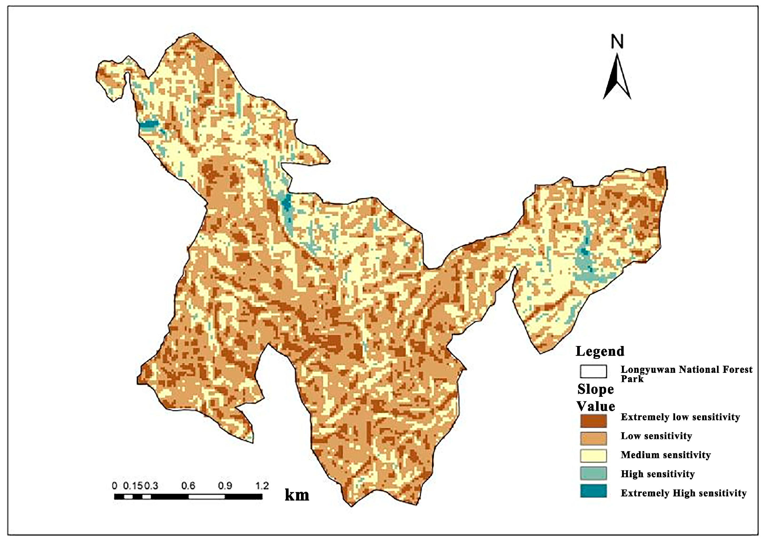
21]. Through the interpretation and analysis of remote sensing imagery in the study area, an assessment utilizing landscape pattern indices revealed that the patch density in the eastern and southwestern marginal zones of the park is significantly higher than that in the core area. This indicates a greater degree of habitat fragmentation in these regions, further corroborating their sensitivity characteristics as ecological transition zones. National forest parks located near urban boundaries, such as Longyuwan, are increasingly recognized as buffers that provide crucial ecological functions including air purification, water regulation, and biodiversity conservation. However, such areas are also vulnerable to land-use change, infrastructure encroachment, and tourism overload. Evaluating their ecological sensitivity using remote sensing and spatial modeling thus becomes essential for proactive forest planning and sustainable urban–rural ecological governance. Ecological sensitivity assessments in mountain forest parks must integrate recreational carrying capacity, which reflects habitat resilience to tourism pressure while accounting for critical factors like slope gradient. This metric serves as a vital management tool to balance conservation and public access in protected areas [
22].
By reviewing the research progress on ecological sensitivity at home and abroad, it can be found that the existing studies mostly focus on the ecological sensitivity evaluation at the scale of cities, nature reserves or river basins [
23]. The research methods mainly include the index system method and GIS spatial analysis, and a relatively mature evaluation framework has been formed [
24]. However, there are still the following research gaps and deficiencies: Limited research areas: Most studies focus on cities or large nature reserves, and there is a lack of research on the ecological sensitivity of forest parks, especially small and medium-sized national forest parks with high forest coverage and high ecological value. The evaluation factors are single: Existing research mostly focuses on natural factors (such as topography, vegetation, and hydrology), and the comprehensive integrated analysis of factors such as atmospheric quality (such as negative oxygen ions and PM
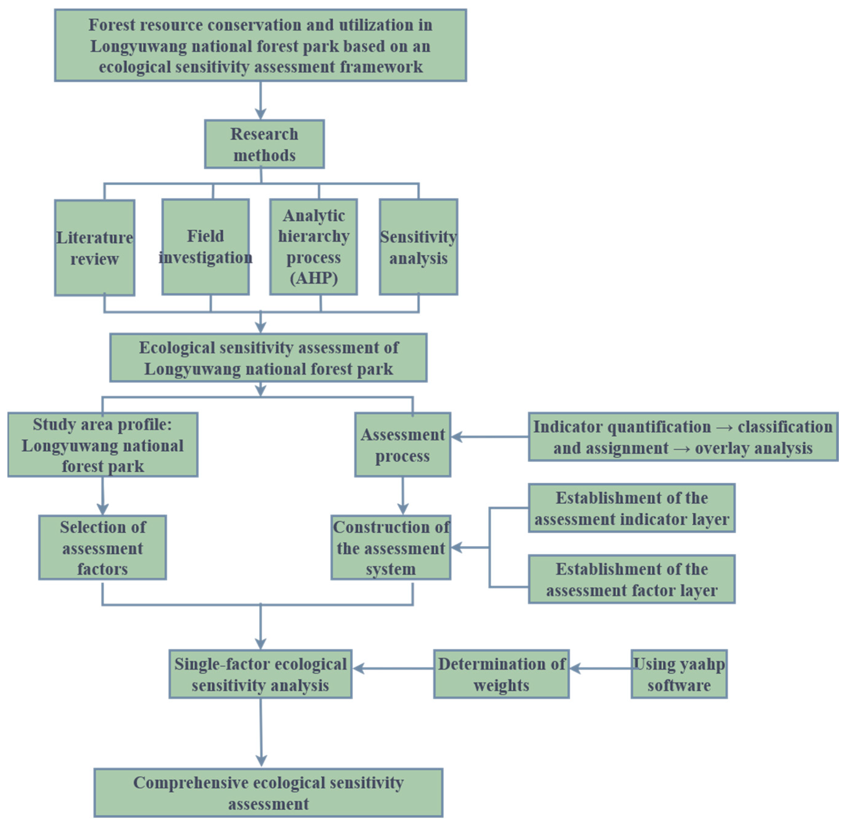
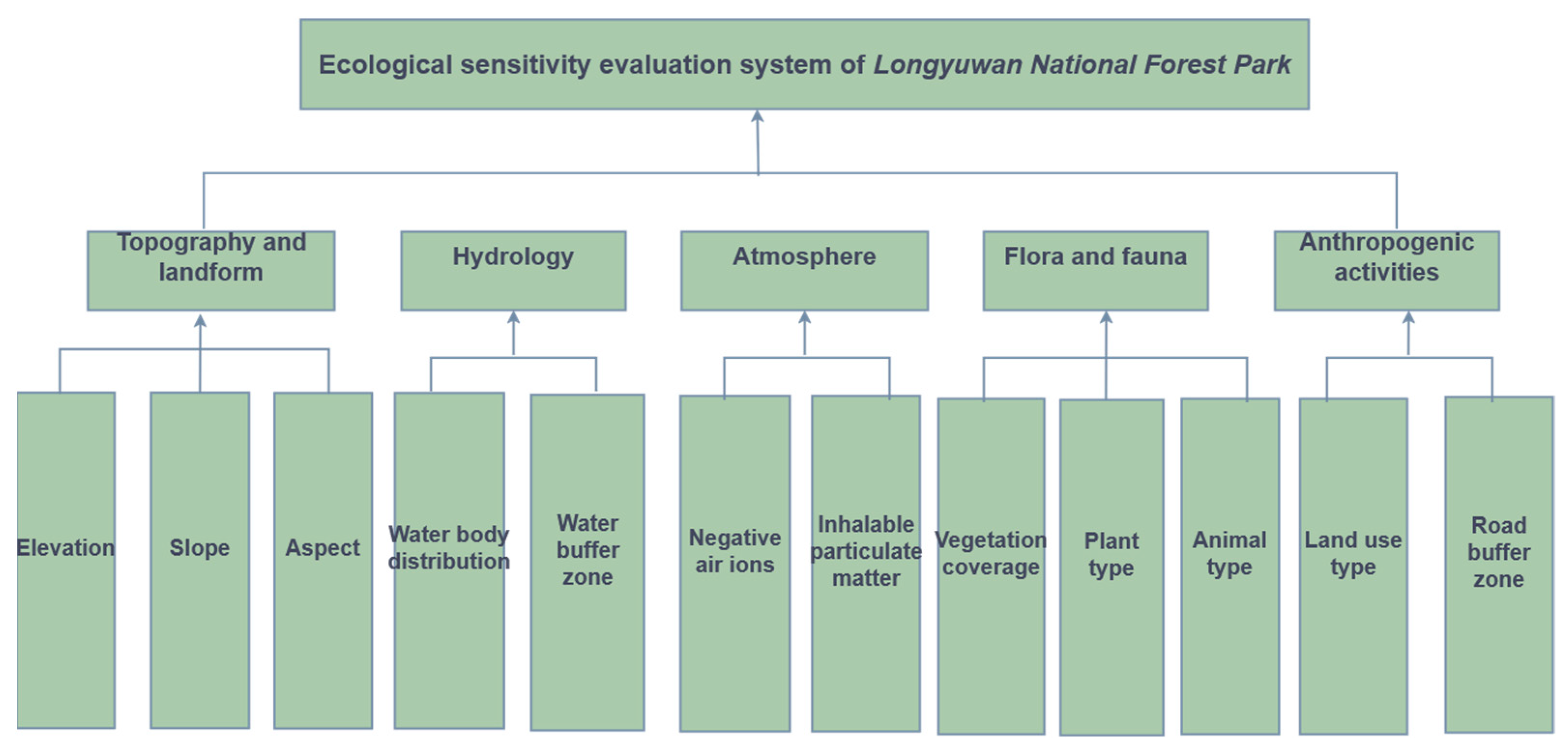
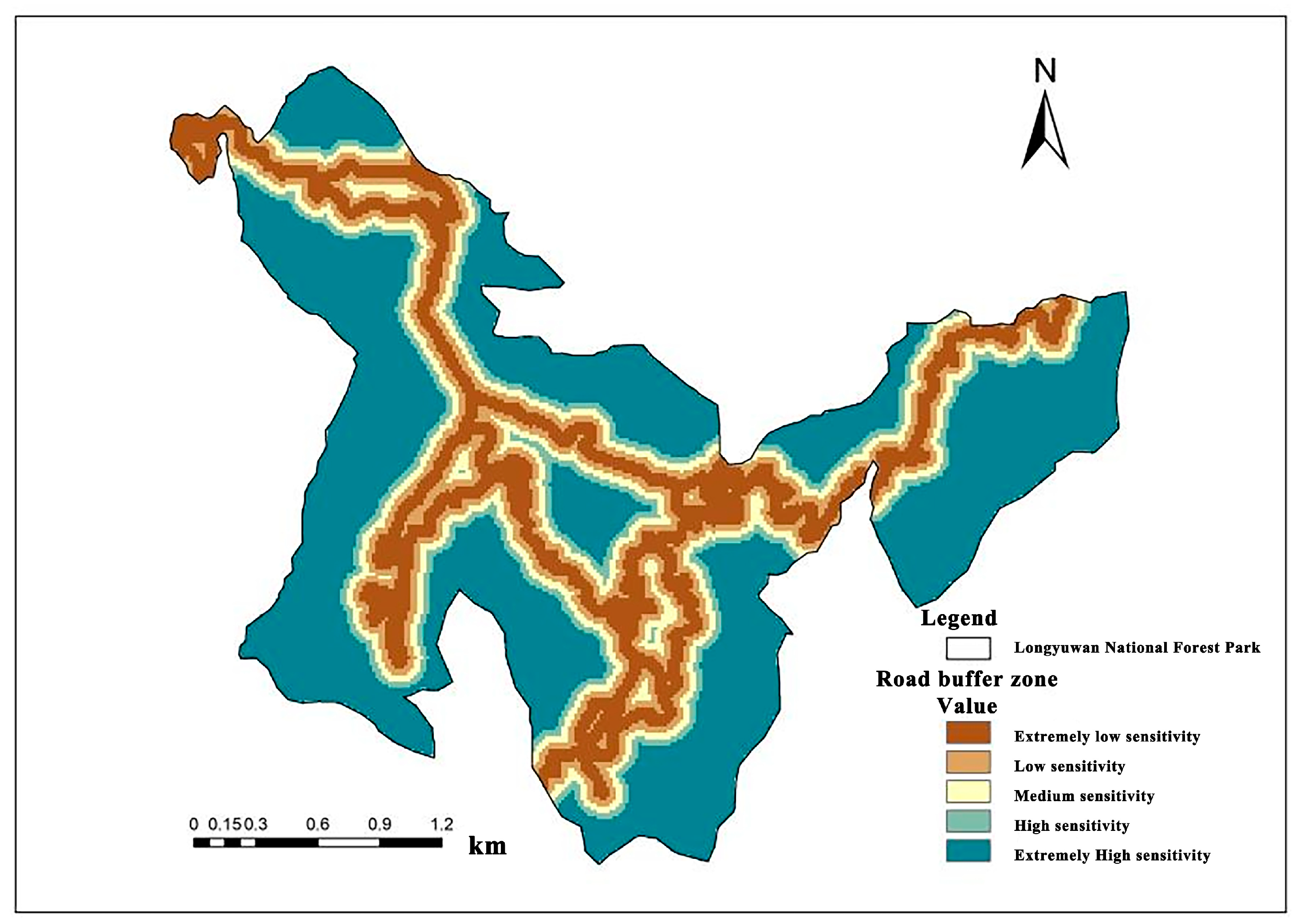
2.5) and human activity buffer zones (such as roads and tourism facilities) is insufficient. Insufficient dynamics and practicality: Most studies remain at the static evaluation level, lacking close integration with specific protection and utilization countermeasures, and have limited practical guidance. Methodological convergence: Although the combination of the Analytic Hierarchy Process (AHP) and GIS is mature, the determination of weights is highly subjective, and there is a lack of multi-source data verification and model optimization. This study takes Longyuwan National Forest Park in Henan Province as the research object and innovatively constructs an ecological sensitivity evaluation system that includes five major system layers: topography and geomorphology, hydrology, atmosphere, flora and fauna, and human activities, as well as 12 index factors. Factors such as air negative ions, inhalable particulate matter, and road buffer zones are particularly introduced. More comprehensively reflect the ecological characteristics of forest parks and their responses to human disturbances. This study adopts the AHP combined with Yaahp 10.1 (Meta Decision Software Technology Co., Ltd., Corp., Shanxi, China) software to determine the weights, and realizes spatial visualization through GIS weighted superposition analysis. The method is mature and highly operable, and is suitable for the sensitivity evaluation of small and medium-scale ecological units. Although AHP has a certain degree of subjectivity, through multiple rounds of expert consultation and consistency verification, the scientificity and credibility of weight setting have been effectively enhanced. This study not only completed the ecological sensitivity assessment, but also further carried out ecological function zoning based on the assessment results, and proposed operational countermeasures for the protection and utilization of forest resources, which has strong practical application value. The research results can provide a scientific basis for the ecological planning, resource management and sustainable development of similar forest parks, especially for the central and western regions that are promoting ecological civilization construction and the rural revitalization strategy.
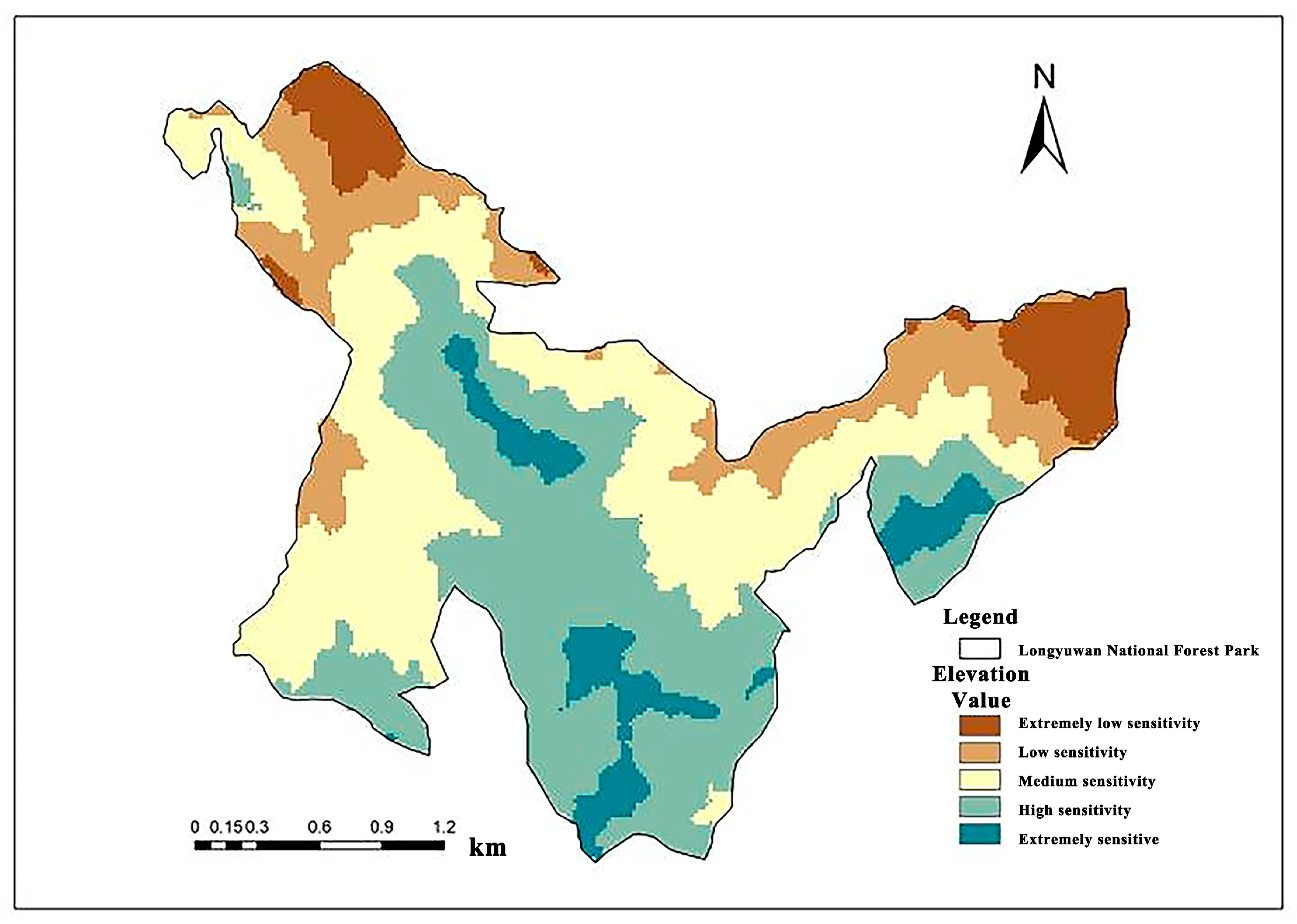
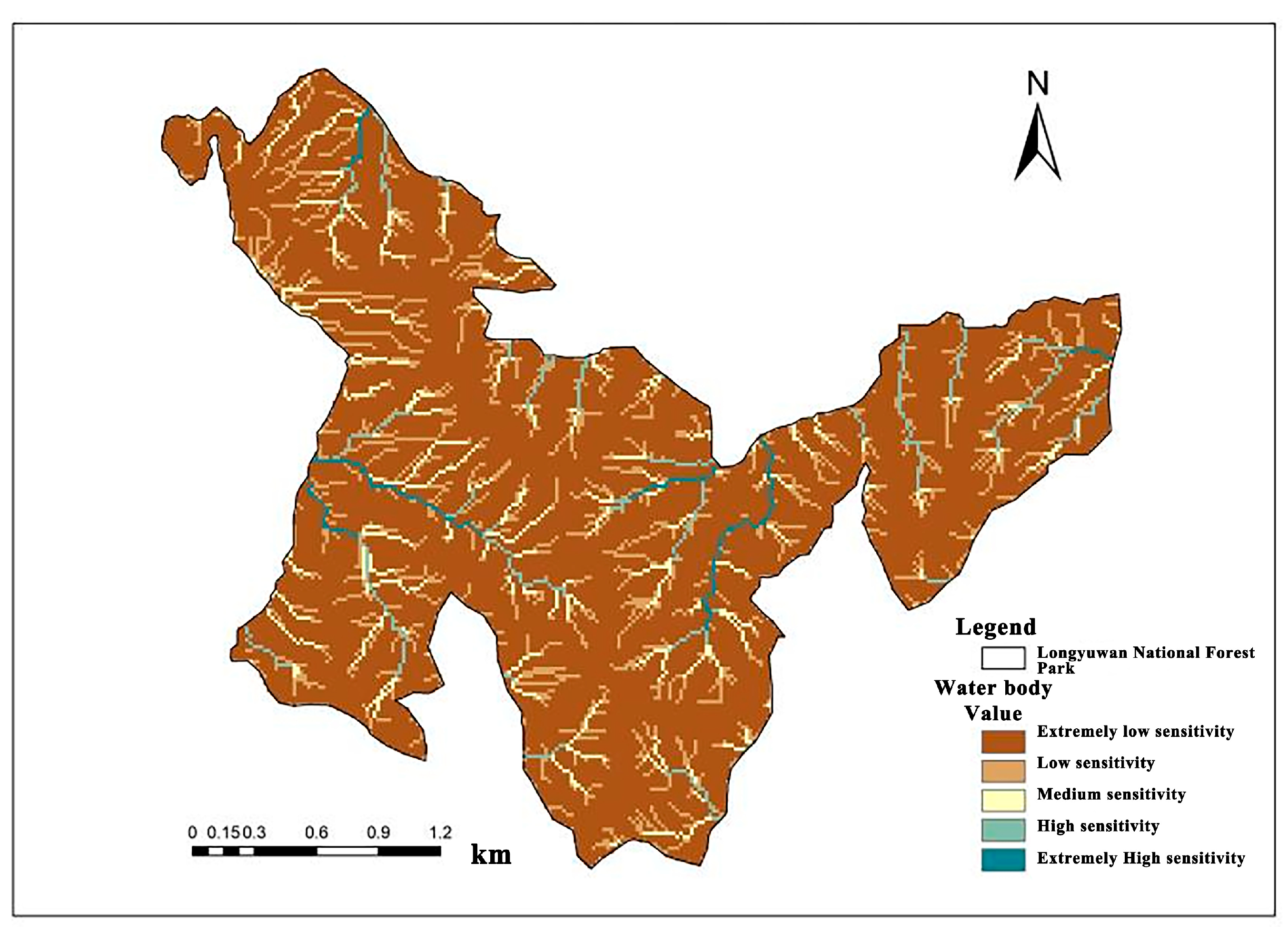
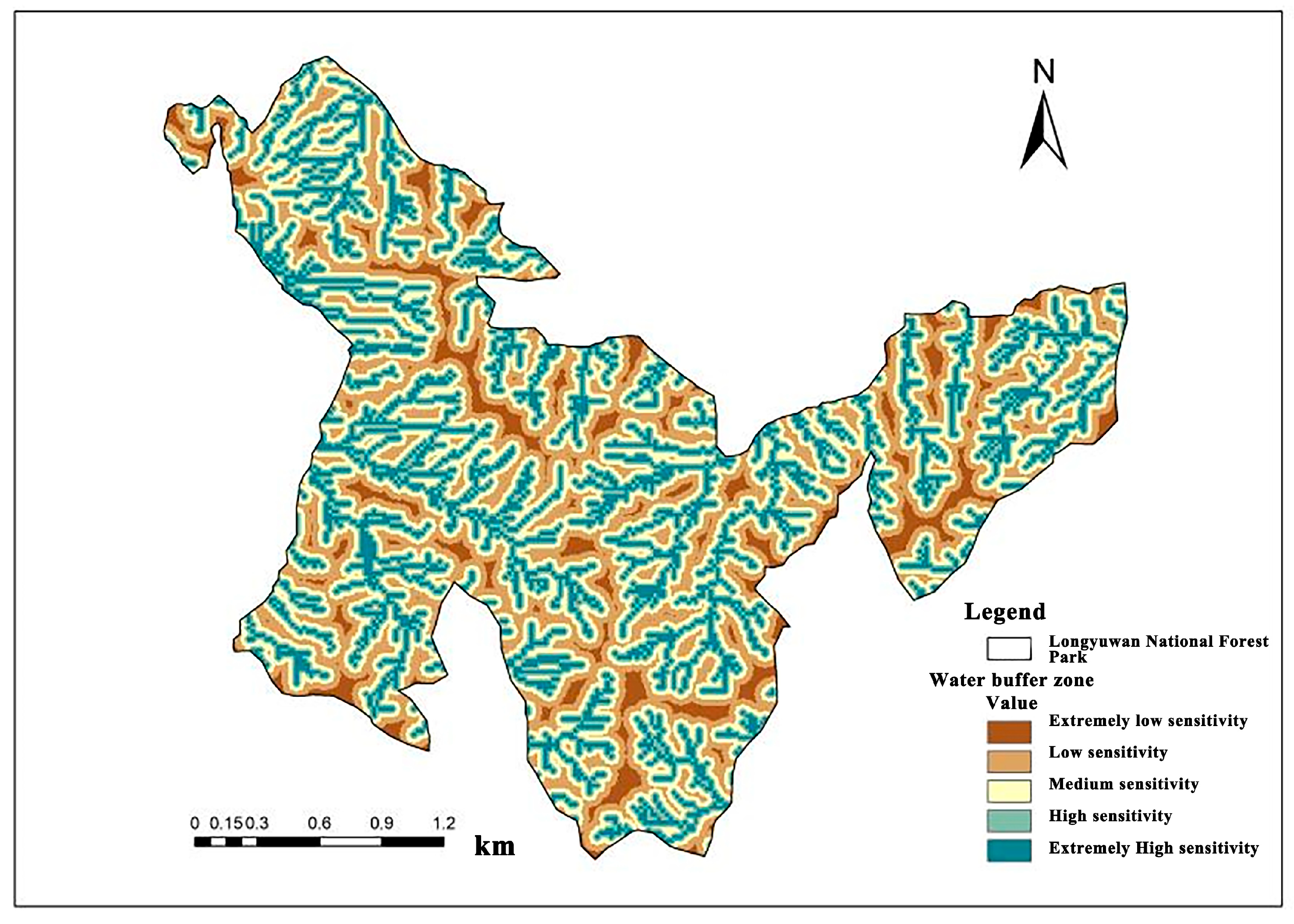
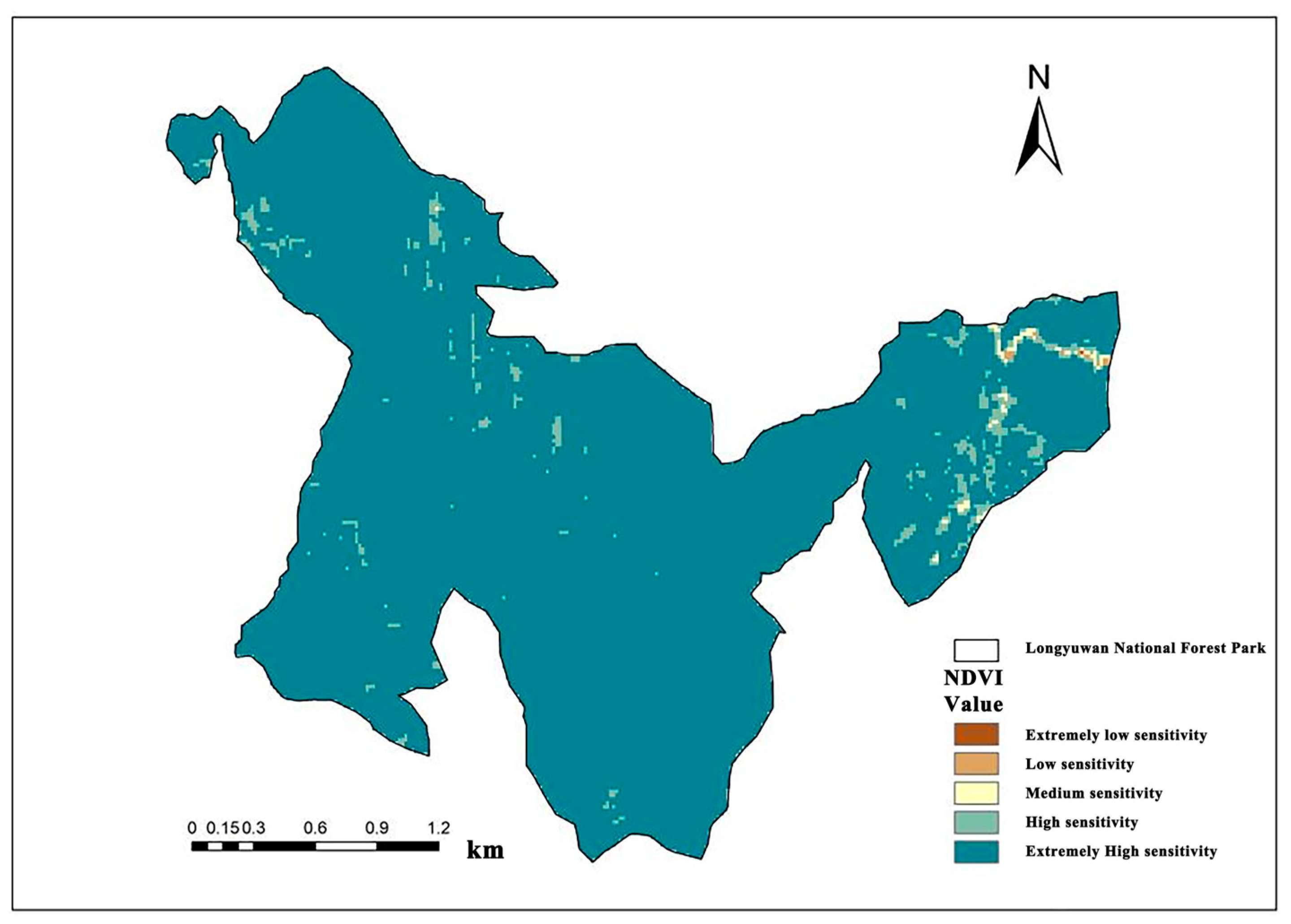
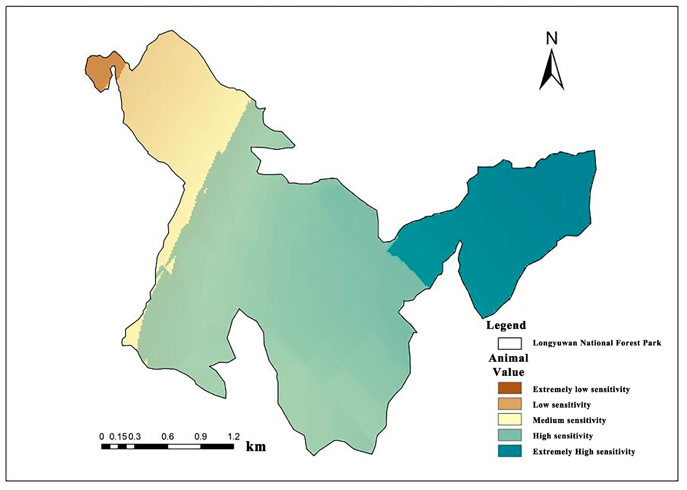
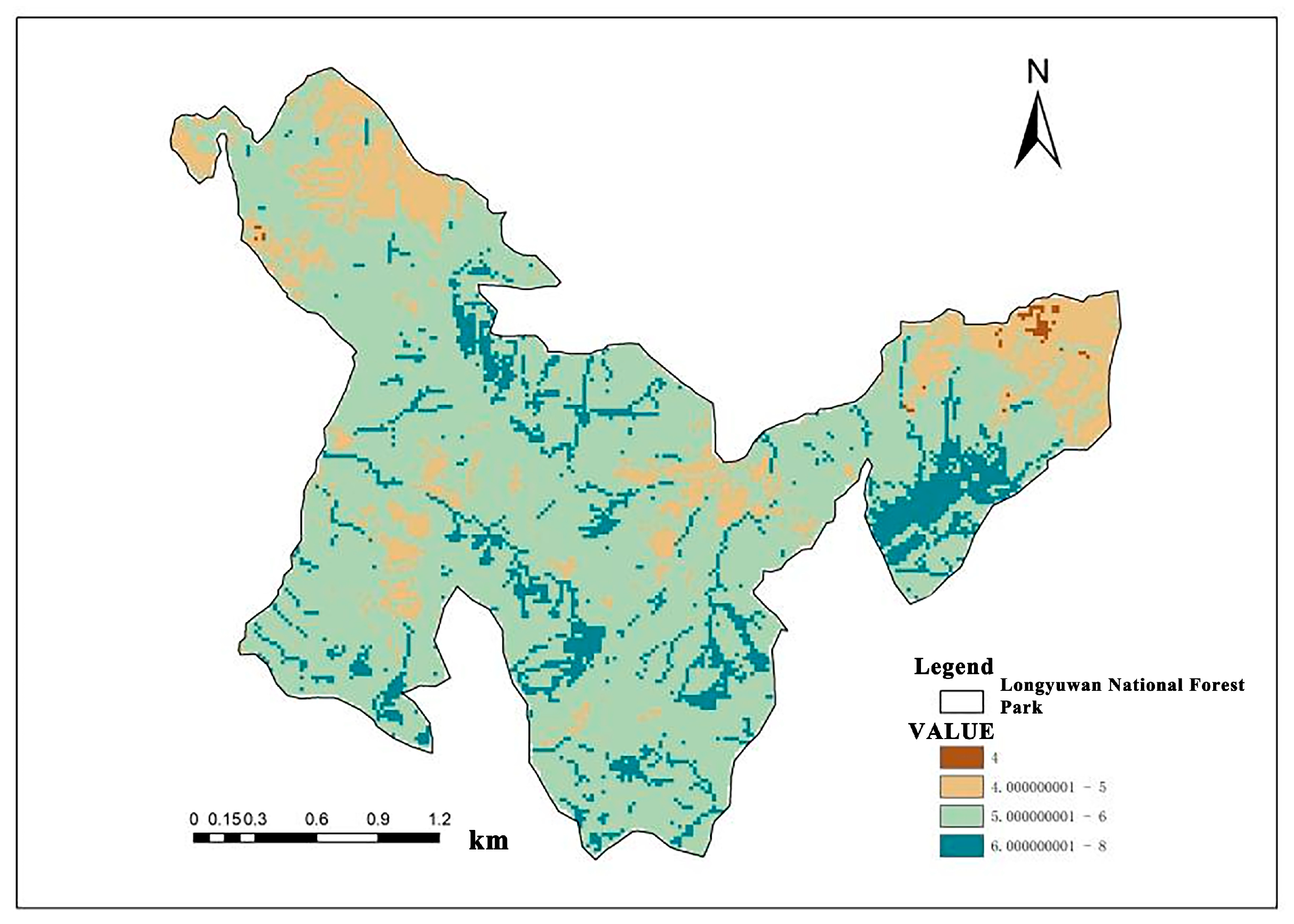
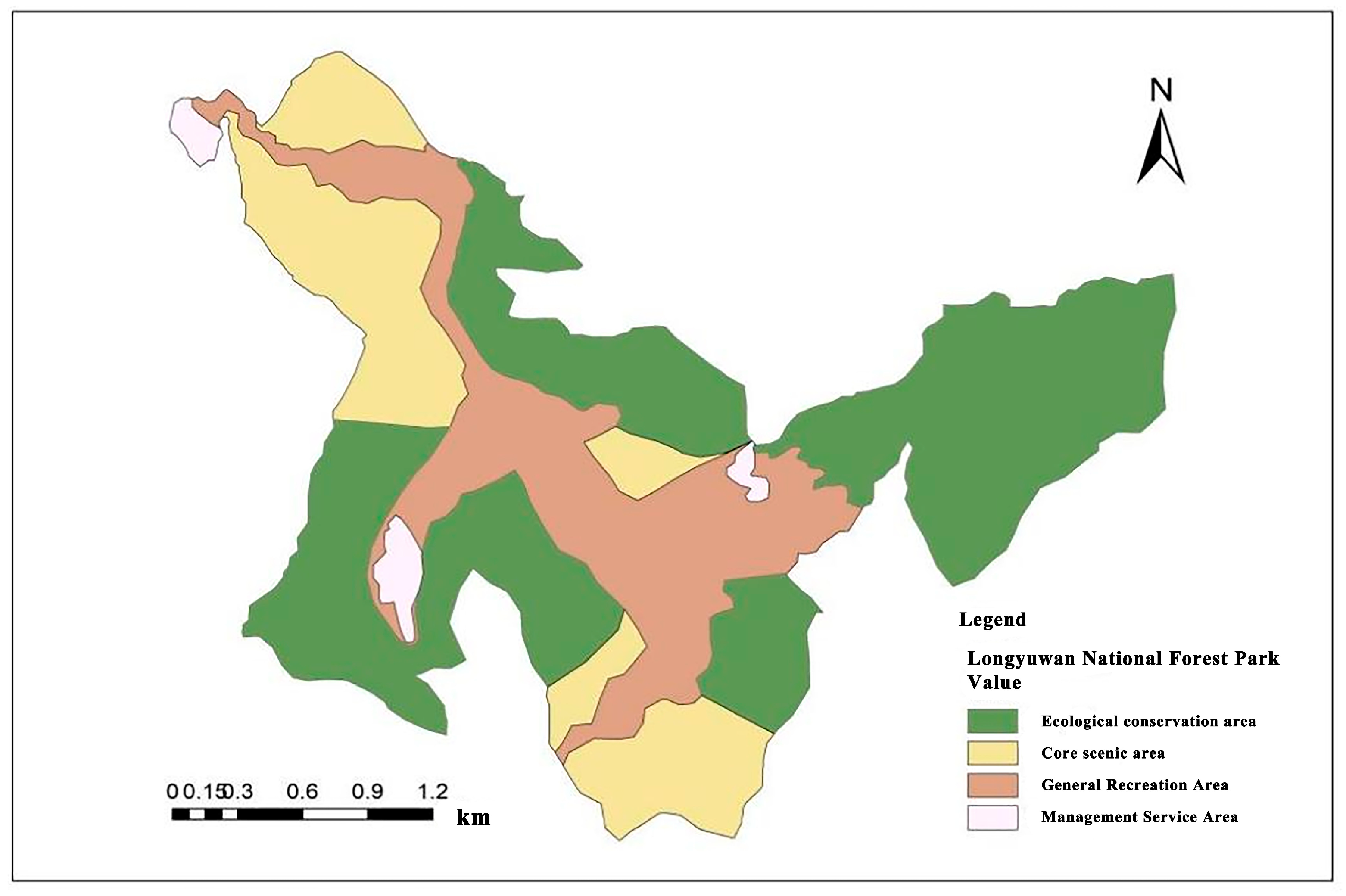
The research objective is to assess the ecological sensitivity of Longyuwan National Forest Park in Luanchuan County, Henan Province, and optimize its spatial functional zoning to achieve a balance between sustainable forest resource development and ecological conservation with rational utilization. Construct an Ecological Sensitivity Evaluation System: Utilize the AHP to establish a multi-level evaluation framework incorporating 12 ecological indicators across five dimensions: geomorphology, hydrology, atmosphere, biology, and anthropogenic activities. Single-Factor and Comprehensive Sensitivity Assessment: Employ spatial analysis tools in ArcGIS 10.2 (Environmental Systems Research Institute, Inc., Redlands, CA, USA) to conduct single-factor sensitivity analyses for each ecological indicator and generate a comprehensive ecological sensitivity distribution map through weighted overlay. Identify Key Influencing Factors: Determine the most impactful indicators on ecological sensitivity and analyze their spatial distribution characteristics. Ecological Sensitivity Grading and Functional Zoning: Based on the evaluation results, classify the park’s ecological sensitivity into five levels and delineate four functional zones to provide a scientific basis for sustainable park management. Theoretical and Practical Support: Offer theoretical and practical guidance for landscape governance in forest-urban interface areas to address potential threats to ecosystem stability from urbanization pressures.
4. Discussion
Forest parks serve as essential carriers for maximizing forest functions, especially the ecosystem services provided by forest ecosystems. They also represent the most critical platform for the development of forest-based tourism [
48]. In the process of advancing ecological civilization, a relatively scientific and complete evaluation system for ecological sensitivity in forest parks has gradually been established. In this study, AHP and spatial analysis methods were employed to evaluate the ecological sensitivity of the forest park. However, with the deepening of research, the interdisciplinary nature of the subject has become increasingly evident, requiring integrated knowledge from ecology, forestry, economics, and geography to support comprehensive evaluations [
49]. Although Longyuwan National Forest Park is not located within a highly urbanized core, its proximity to rural settlements and its designation as a national tourist destination make it an important part of the broader urban–rural ecological network. The findings of this study highlight how landscape sensitivity varies across elevation and human disturbance gradients. This approach can be extended to other ecotonal forest regions that are subject to urban sprawl, helping to preemptively identify areas at risk and inform zoning regulations. Future management strategies should incorporate urban ecological planning principles to ensure that conservation efforts remain adaptive to expanding urban footprints and increasing anthropogenic pressures. Considering limitations in individual capacity, time constraints, and data availability, several shortcomings and areas for improvement in this study are identified:
This study selected 12 evaluation indicators based on the characteristics of Longyuwan National Forest Park to conduct a comprehensive ecological sensitivity analysis. Although the selected indicators aimed to be representative, research on aspects such as forest carbon sequestration, forest-based health and wellness, and ecosystem services remains insufficient. Future research should aim to expand and refine the indicator system to include these important ecological functions.
The selection of indicators was based on a review of existing literature and field investigations, while AHP was used to determine indicator weights. Although every effort was made to ensure objectivity and scientific rigor, the process still involved subjective judgment. Future research should explore more objective and scientifically robust evaluation methods to enhance the overall reliability of results.
Functional zoning of the park was carried out based on the comprehensive ecological sensitivity assessment, and strategies for forest resource protection and development were proposed. However, due to limited resources and capacity, only general suggestions were provided. The implementation and practical application of specific measures need to be further explored and refined.
As the study area is located in Luanchuan County, Luoyang City, Henan Province, which is rich in forest resources, future research could aim to improve the regional ecological sensitivity evaluation system and establish a comprehensive database. This would facilitate ecological interaction and collaborative management among regions.
Sensitivity analysis of weight assignments was not conducted, which constitutes a limitation of this study. Future work will vary the weights of key factors to simulate changes in ecological sensitivity patterns under alternative weighting schemes, thereby testing the robustness of the model and identifying the most influential drivers. Introducing a weight-sensitivity analysis to evaluate the robustness of the weighting configuration will be a priority for subsequent research.
Forest parks are multi-functional landscapes that integrate ecological protection, scientific research, leisure and cultural services. In this study, we applied the AHP and spatial analysis based on Geographic Information System to assess ecological sensitivity and delineate the functional areas of Longyuwan National Forest Park. Our research findings indicate that highly sensitive and highly sensitive areas require strict protection, while low-sensitivity areas can accommodate moderate entertainment and infrastructure construction.
Compared with similar studies, the methodological framework adopted in this study is consistent with the international ecological sensitivity assessment. For instance, similar methods combining multi-criteria Decision Analysis (MCDA) and geographic information system (GIS) technology have been adopted in Mediterranean Forest parks, protected areas in Turkey, and urban ecological parks in China, all of which have confirmed the robustness of spatial-clear sensitivity assessment in guiding land-use planning. Compared with these studies, our research emphasizes the integration of natural indicators and socio-economic indicators, not only highlighting ecological vulnerability but also the pressure on tourism development—a dimension that was less emphasized in earlier international studies [
50].
These results support our initial hypothesis that ecological sensitivity in forest parks is spatially heterogeneous and closely related to topography, vegetation coverage and human disturbances. The highly sensitive area of Longyuwan National Forest Park mainly coincides with steep slopes, high vegetation coverage and key biodiversity habitats, which is consistent with the results of Xuefeng Mountain National Forest Park and other case studies of mountainous areas in China. On the contrary, low-sensitivity areas are located in relatively flat regions with stable secondary forests, which confirms the hypothesis that these areas can sustain greater human activities without endangering ecological stability.
The broader impact of this research lies in its contribution to balancing ecological protection and sustainable utilization in forest parks. By providing an explicit spatial framework, this study offers practical guidance for zoning, biodiversity conservation and tourism planning. In addition, the combination of ecological sensitivity assessment and functional zoning helps to implement China’s ecological civilization strategy and resonates with global discussions on the trade-offs of ecosystem services within protected areas [
37].
However, this study has some limitations. Firstly, although efforts are made to reduce bias through expert scoring and AHP, the screening and weighting of evaluation indicators still involve a certain degree of subjectivity. Secondly, the assessment is based on static datasets, while ecological sensitivity is dynamic and is influenced by climate change, policy changes, and the evolution of human activities. Future research should integrate time monitoring, scenario simulation and participatory stakeholder participation to enhance the robustness and applicability of sensitivity assessment.
5. Conclusions
This study evaluated the ecological sensitivity of Longyuwan National Forest Park and proposed functional zoning strategies to support the balance between ecological conservation and sustainable utilization. By constructing a hierarchical evaluation system with five subsystems and twelve indicators, the results highlighted land-use type, elevation, and water-body distribution as the most influential factors affecting ecological sensitivity. The spatial analysis revealed a clear gradient pattern, with the southern mountainous zones showing higher sensitivity than the northern areas. Overall, the park is dominated by moderate sensitivity (73.53%), with high and extremely high sensitivity zones concentrated in ecologically fragile areas.
Based on the comprehensive sensitivity assessment, the park was divided into four functional zones: ecological conservation, core landscape, general recreation, and management and service. The ecological conservation zone, covering more than half of the park’s total area, was identified as the most critical for biodiversity protection and ecological stability. The core landscape and general recreation zones were delineated to balance scenic value and public use, while the management and service zone was limited to areas of low ecological sensitivity to minimize ecological disturbance.
The functional zoning provides a scientific basis for management strategies that emphasize biodiversity conservation, ecosystem restoration, and rational utilization of forest resources. Strengthening ecological monitoring, optimizing management mechanisms, and promoting sustainable tourism are essential to maintaining the ecological integrity of the park. These findings demonstrate the applicability of integrating ecological sensitivity assessment with spatial planning for forest–urban interface regions, offering valuable insights for similar forest parks under increasing urbanization pressures.

