Article

Water Reservoir Placement Methodology for Forest Firefighting: A Case Study of Valparaíso, Chile

1
Industrial Engineering Department, University of Santiago de Chile, Avenida Victor Jara 3769, Santiago 9170124, Chile
2
Facultad de Ingeniería, Ciencia y Tecnología, Universidad Bernardo O’Higgins, Avenida Viel 1497, Ruta 5 Sur, Santiago 8370993, Chile
3
Escuela de Construcción, Universidad de las Américas, Avenida Manuel Montt 948, Santiago 7500975, Chile
*
Author to whom correspondence should be addressed.
Forests 2024, 15(1), 201; https://doi.org/10.3390/f15010201
Submission received: 2 December 2023 / Revised: 24 December 2023 / Accepted: 8 January 2024 / Published: 19 January 2024
(This article belongs to the Special Issue Forest Fires: Latest Advances and Perspectives)

Abstract

:
Climate change has a significant impact on generating forest fires. These fires damage property, interrupt productive processes, reduce employment sources, and generate direct economic losses. Also, fires contribute to climate change, resulting in a negative cycle. Therefore, the effective management of forest fires is of vital importance. This research focuses on the combat and mitigation phase of forest fires, with special emphasis on using helicopters to transport water from nearby reservoirs to the fire site. The location of these reservoirs is key since a greater distance traveled by helicopter means a longer delay in water transport, which favors the spread of the fire. For this reason, this research proposes an optimization model to determine the optimal location of these reservoirs in a territory. The proposed model is illustrated with a case study of the region of Valparaiso, demonstrating its usefulness for management and decision making when locating reservoirs for firefighting.

1. Introduction

Catastrophic events, such as fires, earthquakes, tsunamis, volcanic eruptions, and floods, are frequent in Chile [1]. Forest fires rank among the most significant natural disasters in the country, causing considerable damage to infrastructure and the lives of the Chilean population. These fires are caused by both natural and human factors [2]; the damage they cause is mainly environmental and economic, in addition to posing a significant risk to people’s lives and property [3,4]; therefore, it is important to combat, prevent, or reduce the damage caused by forest fires. A wildfire is the uncontrolled spread of fire through vegetation. The management of wildfires is divided into four essential phases: disaster mitigation, disaster preparedness, disaster response, and disaster recovery [5,6].
For Ma et al. [7], the main variables that define a fire are the type of vegetation, density, and height of the vegetation, temperature and relative humidity of the air and vegetation fuel, wind speed, topography of the terrain, natural or artificial barriers, additional combustible materials, secondary or new sources of ignition, and the response and effectiveness of the teams and brigades in charge of controlling and extinguishing the fire. According to Mabdeh et al. [8], the main phenomena that define the behavior of a forest fire are combustion (free, complete, incomplete, slow, or intense), surface and high wind, change in wind direction, and updrafts, among others. The speed of spread is a fundamental element that determines the strategy for controlling a forest fire. Based on the effects of the variables and phenomena mentioned above, authors such as Flannigan et al. [9] have proposed three types of forest fires characterized by their spread location: subsoil, surface, and crown fires. During the fire, three stages can be distinguished in relation to its lifetime: initiation, spread, and extinction [10].
Since forest fires are complex and nonlinear dynamic systems, it is necessary to resort to the use of algorithms for their modeling. Among the most widely used tools for the development of susceptibility maps, coverage models, analysis of large volumes of data, and localization of forest fires, several metaheuristics have been identified, including hybrid evolutionary algorithms for evaluating and mapping wildfire susceptibility [8]; biogeography-based optimization (BBO) for fire detection using a system based on the distribution of fire/flame color pixels [11]; a multi-objective programming model for wildfire suppression that considers rescue priority, utilizing the gravitational search algorithm (GSA) [12]; and ant colony optimization (ACO) for predicting temperature distribution in tunnel fires [13] concerning fire duration [14]. ACO is also employed for evacuation route planning [15], and genetic algorithm (GA) is used for data-driven wildfire spread prediction [4,16]. A wildfire early warning system has been developed via particle swarm optimization (PSO) [5], and PSO is applied to identify fire sources in utility tunnels [17]. Additionally, a multi-objective model for wildfire management, considering constraints related to rescue vehicles, has been developed using a differential evolution (DE) algorithm [18].
In addition, artificial intelligence algorithms such as random forest are utilized to analyze the causes of forest fires in China [7] and to classify fire severity based on satellite data [19]. Support vector machine (SVM) is employed for real-time early fire detection and false alarm reduction [20], along with fire detection using multi-channel sensors [21]. Convolutional neural networks (CNN) are applied in resource-limited fire detection systems [22] and for early detection in video surveillance [23]. Machine learning (ML) techniques are used for bushfire susceptibility mapping in Turkey [24], while deep neural networks are employed for bushfire risk prediction in the Northern Beaches area of Sydney [25] and for data-driven risk mapping in China [26], among other applications.
In this study, we focus on the disaster response phase. A crucial aspect of this phase is to act quickly to fight the fire, as the area and perimeter of the affected area increase exponentially as time passes [5]. The earlier a fire is detected, the more successful the firefighting will be, and the less damage will be caused. Therefore, it can be stated that the time interval between the start of the fire and the moment it is fought plays a crucial role in fire control.
The construction of water reservoirs is a crucial initiative for enhancing response capacity and effectiveness in wildfire suppression. These reservoirs guarantee a rapid and stable water supply in strategically identified areas prone to wildfires, thereby improving the efficiency of firefighting operations and reducing risks for emergency teams. Strategically positioned near high-risk zones, forested areas, and vulnerable communities, the selection of their locations is guided by considerations such as accessibility for helicopters and proximity to at-risk populations. Additionally, their placement is informed by historical fire data, existing water sources, land ownership, road accessibility, geographic elevation, and risk studies, among other variables that identify critical areas.
There are several techniques for controlling a forest fire. One of them is the use of helicopters, which transport water from nearby reservoirs to the fire site using Bambi Bucket systems (usually with a capacity of around 2000 L). The presence of strategically located reservoirs facilitates helicopter operations by enabling efficient water supply in close proximity to the fire-affected area. This leads to increased operational efficiency, extended coverage, and reduced risk. For this mitigation approach, it is important to be aware of the location of water reservoirs. The farther the helicopter must travel to collect water, the longer it takes to return, which could potentially facilitate the spread of the fire.

1.1. Contributions and Limitations of the Study

Forest fire management has emerged as a crucial topic, garnering increasing attention within the scientific community. Considering the literature review, this research provides a valuable tool for decision making regarding the location and distribution of reservoirs for firefighting. The objective of this study is to present an optimization model developed for the strategic location of reservoirs used in fire suppression.
The evaluations conducted in this paper demonstrate that the proposed model outperforms typical conventional approaches. The table of results by placed water reservoir shows the improvements as a function of the number of reservoirs assigned, evidencing an improvement in the uncertainty value. The model developed in this work uses spatial aspects such as the distance between points.
Historic data from 2017 may limit the accuracy of optimized reservoir locations. The randomness of wildfires makes it impossible to predict their exact locations and guarantee a 100% optimal location. The on-site verification of satellite data is essential for greater accuracy. The positions identified by the mathematical model must be compared to the initial locations of firefighting helicopters to ensure their operational viability.

1.2. Related Literature

The problem of locating water reservoirs for forest fire fighting has been approached with different approaches. Authors such as Ramalho et al. [27] proposed a methodology for locating reservoirs to combat fires. The methodology is divided into three stages: zoning of the risk of forest fire occurrence using fuzzy logic and multi-criteria analysis and zoning of potential areas to install reservoirs. For this, the authors propose using the same methodology used for fire zoning, considering only variables related to the influence of roads, land use and occupation, water network, and slope. Finally, the last stage consists of determining the optimal locations of the reservoirs using ArcGIS® [28]. Holuša et al. [29] presented a model that uses geospatial and infrastructure data to determine the water supply capacity in different areas and assess whether the requirements for fighting forest fires are met. The results highlight the importance of planning and investment in reservoirs to ensure effective response. Zaimes et al. [30] proposed different tools to prevent and combat forest fires, taking the forest fires in the Black Sea as a case study. Among these tools, multi-criteria methodologies are suggested for decision making on the optimal location of reservoirs. The proposed criteria include the distance from roads, distance from streams, land use, aspect, slope, and accessibility. In addition, a geographic information system (GIS) with spatial analysis is proposed to determine the optimal routes for vehicles to fight the fire. Terêncio et al. [31] proposed a multi-criteria analysis to select the best location for installing rainwater collection ponds in rural areas, considering its use for crop irrigation and forest fire fighting. The proposed variables include pluviometry, soil texture, soil depth, population density, agricultural areas, water quality, forest fire risk, protected areas, stream banks, and terrain slope, and Češljar and Stevović [32] examine the importance of reservoirs for wildfire protection and their role in environmental sustainability.
On the other hand, location and coverage models are used to determine the minimum number of facilities and their geographic location to meet spatially distributed demands [33,34,35,36]. The decision-making process should determine the placement of facilities by considering user requirements and geographical constraints. The objective is to find locations for facilities that satisfy potential customers within a specified distance or travel time [27]. One of the first models for the coverage problem was developed by Toregas et al. [37] for the location of emergency facilities. Other models have been developed [38,39], emphasizing the maximization of the number of covered demands and a hybrid model. Daskin and Stern [40] presented a hierarchical ensemble coverage model, while Bao et al. [41] developed a model for the location of watchtowers intended for wildfire monitoring. Localization models have also been studied in the healthcare sector [42,43]. Authors such as Belanger et al. [44] proposed a model for ambulance location and dispatch problems. The study suggested a combined approach of optimization and recursive simulation, utilizing mathematical models and discrete event simulation. The results showed significant improvements in ambulance response time compared to traditional methods. Furuta and Tanaka [45] presented a model for locating helicopters and transfer points that considers a type of maximum coverage. This model maximizes the number of demand points that can be transferred to the hospitals in a predetermined time. In another study, these authors proposed two approaches for the localization of helicopters and transfer points [46]. Navazi et al. [47] developed a multi-period model for locating ambulance and helicopter stations, assigning demand points, and determining the required bed capacities in hospitals for patients in critical condition.
In the context of wildfires, the potential fire hotspots would correspond to the demand of the problem, and the reservoirs would correspond to the facilities that would supply the water demand.
The case study follows five steps: (i) the selection of the study area based on fire frequency and danger; (ii) the identification of urban areas of interest in the Valparaíso region; (iii) pinpointing areas with the highest probability of fire; (iv) analyzing the limitations and feasibility of water reservoir locations; and (v) determining the feasible location of the water reservoirs. The rest of this paper is organized as follows: Section 2 discusses a wildfire response problem and presents its mathematical model, accompanied by a case study. Section 3 shows the results of the case study. Section 4 discusses the results obtained. Finally, Section 5 concludes our work and describes some future research topics.

2. Materials and Methods

The problem of locating reservoirs for forest fires can be defined as a location-allocation problem. In the context of the supply chain, this type of problem seeks to locate a set of new facilities to minimize transportation costs from the facilities to the customers and, at the same time, meet the customers’ demand [27]. Similarly, considering the problem to be modeled in this research, the objective is to locate the reservoirs in such a way as to effectively combat a forest fire (demand) while simultaneously minimizing distance-time and the costs of using vehicles for mitigating these fires.
The problem being modeled is as follows: (1) there are several points in a geographic space where at least one fire has occurred historically; (2) there is also a specific number of locations where a water reservoir can be installed to combat these fires; and (3) the objective is to determine the number of reservoirs to install to achieve the maximum coverage while also considering the maximum distance a helicopter must travel to put out potential fires. The flow chart of the methodology for locating water reservoirs for wildland firefighting is summarized in Figure 1.

2.1. Mathematic Model

To address the problem, we employed the PuLP library, a Python-based toolkit specifically designed for tackling optimization challenges. Simulations were executed within the Google Collaboratory environment, harnessing its computational capabilities. Equation (1) defines the objective function.
M i n   Z = i = 1 n j = 1 m y i j × d i j
where Z corresponds to the objective function, defined as the weighted sum of transportation costs between each fire point and the water reservoir, multiplied by the binary decision variable indicating whether fire point j is assigned reservoir i. As model constraints, Equations (2)–(4) have been defined. Equation (2) mandates that each point of fire probability must be assigned a water reservoir. Equation (3) specifies the number of water reservoirs to be installed. Furthermore, Equation (4) establishes the relationship between x i and y i j .
i = 1 n y i j = 1 ,     j N   1 , , m
i = 1 n x i = P ,     P N   1 , , n
y i j x i ,     i N   1 , , n ,   j N   1 , , m
Table 1 summarizes the variables and parameters used in the mathematical model.
Equation (1) minimizes the total distance by multiplying the distance between each water reservoir and the demand point by the corresponding binary variable.
Equation (2) ensures that each demand point is served by exactly one water reservoir.
Equation (3) stipulates that precisely, P water reservoirs are to be installed.
Equation (4) establishes the relationship between x i and y i j , ensuring that y i j can only be 1 if x i is also 1.

2.2. Case Study

The study area is the region of Valparaiso (33°03′47″ S, 71°38′22″ W) [48], with an area of 16,396 km2, representing 2.2% of the national territory. It is divided into eight provinces and 38 communes, with the regional capital being the city of Valparaiso. The regional population reaches 1,815,902 inhabitants, which represents 10.3% of the national population, located mainly within the limits of the so-called mesothermal zone. The region’s economic activities are diverse and include mining, fishing, agriculture, industry, and commerce [49]. The predominant climate is of the temperate, Mediterranean type. It is characterized by a dry steppe climate with annual rainfall ranging from 150 to 200 mm. Additionally, there are two temperate climates that can be differentiated based on cloudiness and the duration of the dry period. These climates experience rainfall between 250 and 450 mm per year. The average annual temperature is 15.5 °C, and it varies depending on the location, altitude, and position within the region [50]. The land use in the region of Valparaíso is primarily divided among forestry plantations (37.6%), fruit plantations (34.1%), and forage crops (10.6%). These three categories combined account for 82.3% of the cultivated land in the region. On the other hand, native forests cover 3.28% of the national land surface, which is equivalent to 4,584,116 hectares out of a total of 14,745,110 hectares [49].
This study area was chosen because it is the region with the second number of fires in the country [51] and has a large population close to forested areas. To determine the location of the forest fires, historical information was used that includes the geographic coordinates of the incidents. Based on the above information, Figure 2 illustrates the location of historical fires in the region. To reduce the scope of the model’s application, those communes with historically more fires were selected. These data played a key role in all stages of the graphical information analysis performed with ArcGIS® software desktop 10.8.1 (ESRI CHILE, Santiago, Chile) to show the possible locations of the reservoirs.
The selection of specific communes within the Valparaíso region is driven by compelling evidence indicating a high prevalence of forest fires in these areas.
Detailed analysis of historical data unveils a persistent pattern of forest fires afflicting these communes. This selection strategy will enable more precise and solution-oriented research tailored to the specific needs of these communes, aiming to develop effective prevention and mitigation measures. In Figure 3, four study communes are defined: Villa Alemana, Valparaíso, Viña del Mar, and Quilpué.
The fire problem is centered in the urban area; therefore, a three-kilometer radius around these areas was chosen to establish the feasible location system and determine the zones for fire suppression. Additionally, three radii encircling the urban area (300 m, 500 m, 1000 m, and 3000 m) are visualized.
This study advocates for the adoption of a 1 km2 grid due to its effectiveness in generating coverage zones and feasible locations for forest fire analysis (Figure 4).
The adoption of a 1 km2 grid facilitates the capture of local-level patterns, enabling the precise identification of critical areas and the effective implementation of predictive models and geospatial analysis.

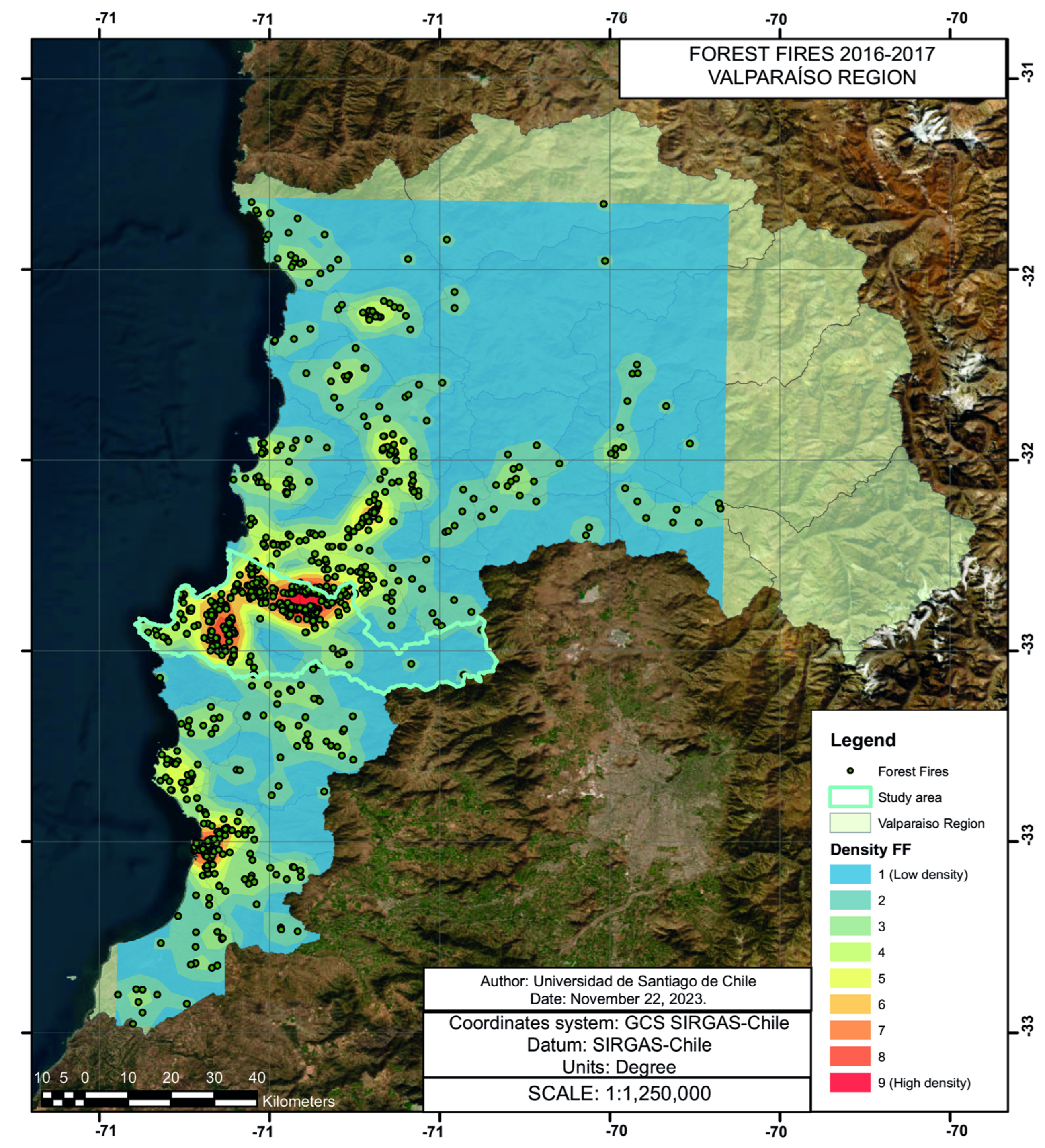
2.2.1. Coverage Area

To identify areas with a higher probability of fires, two criteria were employed: (i) areas with a documented history of fires during the 2016–2017 season and (ii) vegetation quality index values between 0.2 and 0.5, indicating stressed vegetation (Figure 5).
The region’s characteristics and the vegetation’s state warrant comprehensive coverage of the entire area depicted in the grid.

2.2.2. Coverage Area

Geospatial information obtained from public databases is employed to establish constraints for the placement of water reservoirs. Figure 6 shows the following three constraints.
  • To facilitate accessibility for the filling system, water reservoirs must be situated within a maximum distance of 1 km from the road network.
  • Due to installation challenges and redundancy in placing water resources in these areas, constructing water reservoirs on the hydrographic network or lake bodies is prohibited.
  • Water reservoirs should be sited at a safe distance from power transmission lines to eliminate potential hazards arising from helicopter rotor movement.
Figure 6. Map with water reservoir placement restrictions.
Forests 15 00201 g006
The region’s topography serves as the final criterion for delineating feasible zones. Both flight operations and water reservoir design are facilitated by gentle slopes, restricting feasible locations within the area to those with gradual inclines (Figure 7).
Based on Figure 7, 17 potentially feasible zones have been identified. These zones will be integrated into an optimization model to determine the optimal locations and minimize the cumulative distance between firefighting points and water reservoirs.

3. Results

The geospatial data table was constructed within the ArcGIS system. This workflow was automated by Python scripts executed from Google Colaboratory.
The processed geospatial information yields n = 663 and m   = 17, parameters used in the optimization model. A cumulative distance analysis was performed using the outputs of Equation (1) to determine the required number of water reservoirs. This analysis considers the total distance traveled for all demand points to reach their assigned water reservoirs (Figure 8).
The initial cost of the water reservoir system decreases as more reservoirs are added. However, starting with four reservoirs, the rate of cost reduction is increasingly lower. This is attributed to the gradual distribution of feasibility zones, rendering additional reservoirs less effective in reducing distances. As a result, the curve of the results becomes smoother and tends toward linearity. Based on the above analysis, the choice is to utilize the curve’s elbow to determine the number of water reservoirs, thereby generalizing the optimization model with p   = 4; i = 17 17 x i = 4 (Figure 9).
As a result, the optimization model indicates the optimal location for the water reservoirs. In addition, it allows determining the allocation of each reservoir and the direction it should be directed to combat the fire.
The model segments the study regions into four distinct areas. Additionally, it determines the distance in kilometers that each water reservoir must serve. The information layers integrated into Figure 9 include water tributaries, the road network, and high-voltage power lines. This information facilitates the identification of easily accessible installation points for the water reservoirs, ensuring efficient monitoring and preventive maintenance. Furthermore, the imposed restrictions guarantee the safe movement of helicopters for water supply during firefighting.
It should be noted that this study does not address the aspect of land ownership where water reservoirs are installed. All topographic variables and geographical altitudes are represented in Figure 10.
It is important to note that the reservoir positions are strategically located at an altitude below 500 m above sea level. This significantly minimizes the time and challenges involved in filling the reservoirs.
Table 2 presents the number of fire points assigned to each water reservoir, along with the corresponding maximum distances. These data serve to determine critical values, including the maximum distance a helicopter should reach from each reservoir. It is also used to calculate an average distance value from the reservoirs to all identified fire locations.

4. Discussion

Previous research has attempted to address the problem of water reservoir location for firefighting [30,31]. For example, the most recent proposes a methodology for their placements [27]. However, most studies propose multicriteria approaches and the use of geographic location software to make such decisions, not finding in the literature a model that allows, under certain conditions, establishing the optimal configuration of the network of reservoirs to be installed.
In this study, we presented an optimization model that finds the ideal configuration of the reservoir network to be installed. The model’s objective is to maximize the allocation of fires to each water reservoir, considering distance constraints and ensuring that all fires are attended by at least one reservoir.
The use of the model has been illustrated in the case study of the region of Valparaiso, one of the areas most affected by forest fires in the country. The results indicate the model’s usefulness in decision making and fire management.
The model developed in this research has several implications from a management perspective. Firstly, the model can be used to locate reservoirs near urban areas, which would help prevent forest fires from reaching these areas. The model can also be applied in managing forest exploitation areas, as the strategic location of reservoirs would effectively help combat fires and protect the raw forest material. In terms of decision making, the model is also useful for evaluating different configurations and goals. For example, different amounts of reservoirs to install can be considered, which can increase coverage but also increase implementation costs. In this sense, the model can be used to evaluate different implementation options and make the best decision considering costs, coverage, and the decision maker’s preferences.
The model, although effective, has limitations, such as not considering the probability of occurrence or magnitude of fires in each potential area. Additionally, it does not take into account the available water transport capacity, nor does it determine the necessary capacity for each reservoir at each potential installation point. Another aspect not considered is the negative environmental impacts, such as avoiding the contamination of nearby water sources and minimizing damage to flora and fauna.

5. Conclusions

This work proposes an optimization model as a decision-making tool for locating reservoirs for firefighting. The model determines the location of the water reservoirs by considering that the distance between them and at least one of the potential fire sources must be less than a previously defined maximum distance.
The model supports decision making regarding the management of forest fires near urban areas and in areas of forest exploitation. In this research, the Valparaíso region was considered to illustrate the application of the model.
The model developed in this work only considers spatial aspects, such as the distance between points. However, forest fire management needs the consideration of other aspects, such as the probability of a forest fire occurring in a specific location, the risk of the fire, its magnitude, the pond capacity, etc., which can be integrated into the model in future research.
Also, an optimization model is integrated into a management methodology that incorporates multiple stages to incorporate other relevant variables into the practical implementation in the field. This creates a management tool for disaster experts, enabling them to anticipate situations generated by fires. Making timely decisions is crucial for preserving the territory and saving lives.
Future works could address the challenge of coordinating helicopter movement with the positions of water reservoirs, for example, by optimizing refill routes based on anticipated fire location and existing reservoir levels. Additionally, it is necessary to assess the capacities of the reservoirs to meet the defined coverage in attack zones. On the other hand, the evaluation of the costs of the different reservoir filling and implementation strategies will be crucial for minimizing the overall expenses associated with these solutions.

Author Contributions

Conceptualization, P.S. and M.V.; methodology, G.F. and M.A.; software, R.T. and P.S.; validation, M.V. and M.A.; formal analysis, P.S. and M.A.; investigation, G.F. and M.A.; resources, R.T.; data curation, M.V.; writing—original draft preparation, M.V.; writing—review and editing, G.F.; visualization, R.T.; supervision, R.T.; project administration, G.F.; funding acquisition, P.S. All authors have read and agreed to the published version of the manuscript.

Funding

This research was supported by the DICYT (Scientific and Technological Research Bureau) of the University of Santiago of Chile (USACH) and the Department of Industrial Engineering. DICYT project: Optimization of coverage and location of water reservoirs to extinction forest fires, code 062217AM.

Data Availability Statement

Data are available at [52].

Conflicts of Interest

The authors declare that there are no conflicts of interest regarding the publication of this paper.

References

  1. Ternero, R.; Sepúlveda, J.; Alfaro, M.; Fuertes, G.; Vargas, M.; Sepúlveda-Rojas, J.P.; Soto-Jancidakis, L. Analysis of pedestrian behavior for the optimization of evacuation plans in tall buildings: Case study Santiago, Chile. Buildings 2023, 13, 2907. [Google Scholar] [CrossRef]
  2. Sivrikaya, F.; Küçük, Ö. Modeling forest fire risk based on GIS-based analytical hierarchy process and statistical analysis in Mediterranean region. Ecol. Inform. 2022, 68, 101537. [Google Scholar] [CrossRef]
  3. Tiwari, A.; Shoab, M.; Dixit, A. GIS-based forest fire susceptibility modeling in Pauri Garhwal, India: A comparative assessment of frequency ratio, analytic hierarchy process and fuzzy modeling techniques. Nat. Hazards 2021, 105, 1189–1230. [Google Scholar] [CrossRef]
  4. Pereira, J.; Mendes, J.; Júnior, J.S.S.; Viegas, C.; Paulo, J.R. A review of genetic algorithm approaches for wildfire spread prediction calibration. Mathematics 2022, 10, 300. [Google Scholar] [CrossRef]
  5. Supriya, Y.; Gadekallu, T.R. Particle swarm-based federated learning approach for early detection of forest fires. Sustainability 2023, 15, 964. [Google Scholar] [CrossRef]
  6. Sun, W.; Bocchini, P.; Davison, B.D. Applications of artificial intelligence for disaster management. Nat. Hazards 2020, 103, 2631–2689. [Google Scholar] [CrossRef]
  7. Ma, W.; Feng, Z.; Cheng, Z.; Chen, S.; Wang, F. Identifying forest fire driving factors and related impacts in China using random forest algorithm. Forests 2020, 11, 507. [Google Scholar] [CrossRef]
  8. Mabdeh, A.N.; Al-Fugara, A.; Khedher, K.M.; Mabdeh, M.; Al-Shabeeb, A.R.; Al-Adamat, R. Forest fire susceptibility assessment and mapping using support vector regression and adaptive neuro-fuzzy inference system-based evolutionary algorithms. Sustainability 2022, 14, 9446. [Google Scholar] [CrossRef]
  9. Flannigan, M.D.; Stocks, B.J.; Wotton, B.M. Climate change and forest fires. Sci. Total Environ. 2000, 262, 221–229. [Google Scholar] [CrossRef]
  10. Abdo, H.G.; Almohamad, H.; Al Dughairi, A.A.; Al-Mutiry, M. GIS-based frequency ratio and analytic hierarchy process for forest fire susceptibility mapping in the western region of Syria. Sustainability 2022, 14, 4668. [Google Scholar] [CrossRef]
  11. Toptaş, B.; Hanbay, D.; Yeroǧlu, C. Separation of fire images with biogeography-based optimization. In Proceedings of the IEEE International Conference on Artificial Intelligence and Data Processing, Malatya, Turkey, 28–30 September 2018. [Google Scholar] [CrossRef]
  12. Tian, G.; Fathollahi-Fard, A.M.; Ren, Y.; Li, Z.; Jiang, X. Multi-objective scheduling of priority-based rescue vehicles to extinguish forest fires using a multi-objective discrete gravitational search algorithm. Inf. Sci. 2022, 608, 578–596. [Google Scholar] [CrossRef]
  13. Xu, L.; Huang, K.; Liu, J.; Li, D.; Chen, Y.F. Intelligent planning of fire evacuation routes using an improved ant colony optimization algorithm. J. Build. Eng. 2022, 61, 105208. [Google Scholar] [CrossRef]
  14. Sun, B. Adaptive modified ant colony optimization algorithm for global temperature perception of the underground tunnel fire. Case Stud. Therm. Eng. 2022, 40, 102500. [Google Scholar] [CrossRef]
  15. Sun, B.; Hu, Z.; Liu, X.; Xu, Z.D.; Xu, D. A physical model-free ant colony optimization network algorithm and full scale experimental investigation on ceiling temperature distribution in the utility tunnel fire. Int. J. Therm. Sci. 2022, 174, 107436. [Google Scholar] [CrossRef]
  16. Dong, Z.; Yu, J.; An, S.; Zhang, J.; Li, J.; Xu, D. Forest fire detection of FY-3D using genetic algorithm and brightness temperature change. Forests 2022, 13, 963. [Google Scholar] [CrossRef]
  17. Liu, X.; Sun, B.; Xu, Z.D.; Liu, X. An adaptive particle swarm optimization algorithm for fire source identification of the utility tunnel fire. Fire Saf. J. 2021, 126, 103486. [Google Scholar] [CrossRef]
  18. Tian, G.; Ren, Y.; Zhou, M. Dual-objective scheduling of rescue vehicles to distinguish forest fires via differential evolution and particle swarm optimization combined algorithm. IEEE Trans. Intell. Transp. Syst. 2016, 17, 3009–3321. [Google Scholar] [CrossRef]
  19. de Santana, R.O.; Delgado, R.C.; Schiavetti, A. Modeling susceptibility to forest fires in the Central Corridor of the Atlantic Forest using the frequency ratio method. J. Environ. Manag. 2021, 296, 113343. [Google Scholar] [CrossRef]
  20. Collins, L.; McCarthy, G.; Mellor, A.; Newell, G.; Smith, L. Training data requirements for fire severity mapping using Landsat imagery and random forest. Remote Sens. Environ. 2020, 245, 111839. [Google Scholar] [CrossRef]
  21. Chen, S.; Ren, J.; Yan, Y.; Sun, M.; Hu, F.; Zhao, H. Multi-sourced sensing and support vector machine classification for effective detection of fire hazard in early stage. Comput. Electr. Eng. 2022, 101, 108046. [Google Scholar] [CrossRef]
  22. Baek, J.; Alhindi, T.J.; Jeong, Y.S.; Jeong, M.K.; Seo, S.; Kang, J.; Choi, J.; Chung, H. Real-time fire detection algorithm based on support vector machine with dynamic time warping kernel function. Fire Technol. 2021, 57, 2929–2953. [Google Scholar] [CrossRef]
  23. de Venâncio, P.V.A.B.; Lisboa, A.C.; Barbosa, A.V. An automatic fire detection system based on deep convolutional neural networks for low-power, resource-constrained devices. Neural Comput. Appl. 2022, 34, 15349–15368. [Google Scholar] [CrossRef]
  24. Huang, L.; Liu, G.; Wang, Y.; Yuan, H.; Chen, T. Fire detection in video surveillances using convolutional neural networks and wavelet transform. Eng. Appl. Artif. Intell. 2022, 110, 104737. [Google Scholar] [CrossRef]
  25. Akıncı, H.A.; Akıncı, H. Machine learning based forest fire susceptibility assessment of Manavgat district (Antalya), Turkey. Earth Sci. Inform. 2023, 16, 397–414. [Google Scholar] [CrossRef]
  26. Naderpour, M.; Rizeei, H.M.; Ramezani, F. Forest fire risk prediction: A spatial deep neural network-based framework. Remote Sens. 2021, 13, 2513. [Google Scholar] [CrossRef]
  27. Ramalho, A.H.; da Silva, E.F.; Silva, J.P.; Fiedler, N.C.; Maffioletti, F.D.; Biazatti, L.D.; Moreira, T.R.; Juvanhol, R.S.; Dos Santos, A.R. Allocation of water reservoirs to fight forest fires according to the risk of occurrence. J. Environ. Manag. 2021, 296, 113122. [Google Scholar] [CrossRef] [PubMed]
  28. ArcGIS. Cartographic Rendering Software. Available online: https://www.arcgis.com/home/index.html (accessed on 30 November 2022).
  29. Holuša, J.; Koreň, M.; Berčák, R.; Resnerová, K.; Trombik, J.; Vaněk, J.; Szczygieł, R.; Chromek, I. A simple model indicates that there are sufficient water supply points for fighting forest fires in the Czech Republic. Int. J. Wildland Fire 2021, 30, 428–439. [Google Scholar] [CrossRef]
  30. Zaimes, G.N.; Tufekcioglu, M.; Tufekcioglu, A.; Zibtsev, S.; Corobov, R.; Emmanouloudis, D.A.; Uratu, R.; Ghulijanyan, A.; Trombitsky, I. Transboundary collaborations to enhance wildfire suppression in protected areas of the black sea region. J. Eng. Sci. Technol. Rev. 2016, 9, 108–114. [Google Scholar] [CrossRef]
  31. Terêncio, D.P.S.; Fernandes, L.F.S.; Cortes, R.M.V.; Moura, J.P.; Pacheco, F.A.L. Rainwater harvesting in catchments for agro-forestry uses: A study focused on the balance between sustainability values and storage capacity. Sci. Total Environ. 2018, 613–614, 1079–1092. [Google Scholar] [CrossRef]
  32. Češljar, G.; Stevović, S. Small reservoirs and their sustainable role in fires protection of forest resources. Renew. Sustain. Energy Rev. 2015, 47, 496–503. [Google Scholar] [CrossRef]
  33. Fuertes, G.; Alfaro, M.; Soto, I.; Carrasco, R.; Iturralde, D.; Lagos, C. Optimization model for location of RFID antennas in a supply chain. In Proceedings of the IEEE International Conference on Computers Communications and Control, Oradea, Romania, 8–12 May 2018; pp. 203–209. [Google Scholar] [CrossRef]
  34. Çolak, E.; Sunar, F. Evaluation of forest fire risk in the Mediterranean Turkish forests: A case study of Menderes region, Izmir. Int. J. Disaster Risk Reduct. 2020, 45, 101479. [Google Scholar] [CrossRef]
  35. Rubio, C.; Alfaro, M.; Mejia-Giraldo, A.; Fuertes, G.; Mosquera, R.; Vargas, M. Multivariate analysis in data science for the geospatial distribution of the breast cancer mortality rate in Colombia. Front. Oncol. 2023, 12, 7325. [Google Scholar] [CrossRef]
  36. Razavi-Termeh, S.V.; Sadeghi-Niaraki, A.; Choi, S.M. Ubiquitous GIS-based forest fire susceptibility mapping using artificial intelligence methods. Remote Sens. 2020, 12, 1689. [Google Scholar] [CrossRef]
  37. Toregas, C.; Swain, R.; ReVelle, C.; Bergman, L. The location of emergency service facilities. Oper. Res. 1971, 19, 1363–1373. [Google Scholar] [CrossRef]
  38. Church, R.; Velle, C.R. The maximal covering location problem. Pap. Reg. Sci. 1974, 32, 101–118. [Google Scholar] [CrossRef]
  39. Mohri, S.S.; Akbarzadeh, M.; Matin, S.H.S. A hybrid model for locating new emergency facilities to improve the coverage of the road crashes. Socioecon. Plan. Sci. 2020, 69, 100683. [Google Scholar] [CrossRef]
  40. Daskin, M.S.; Stern, E.H. A hierarchical objective set covering model for emergency medical service vehicle deployment. Transp. Sci. 1981, 15, 137–152. [Google Scholar] [CrossRef]
  41. Bao, S.; Xiao, N.; Lai, Z.; Zhang, H.; Kim, C. Optimizing watchtower locations for forest fire monitoring using location models. Fire Saf. J. 2015, 71, 100–109. [Google Scholar] [CrossRef]
  42. Gould, P.R.; Leinbach, T.R. Approach to the geographic assignment of hospital services. Tijdschr. Econ. Soc. Geogr. 1966, 57, 203–206. [Google Scholar]
  43. Ghaderi, A.; Momeni, M. A multi-period maximal coverage model for locating simultaneous ground and air emergency medical services facilities. J. Ambient. Intell. Humaniz. Comput. 2021, 12, 1577–1600. [Google Scholar] [CrossRef]
  44. Bélanger, V.; Lanzarone, E.; Nicoletta, V.; Ruiz, A.; Soriano, P. A recursive simulation-optimization framework for the ambulance location and dispatching problem. Eur. J. Oper. Res. 2020, 286, 713–725. [Google Scholar] [CrossRef]
  45. Furuta, T.; Tanaka, K.-I. A maximal covering model for helicopter emergency medical systems. In Proceedings of the Ninth International Symposium on Operations Research and Its Applications, Chengdu, China, 19–23 August 2010; pp. 2263–2278. [Google Scholar]
  46. Furuta, T.; Tanaka, K.-I. Minisum and minimax location models for helicopter emergency medical service systems. J. Oper. Res. Soc. Jpn. 2013, 56, 221–242. [Google Scholar] [CrossRef]
  47. Navazi, F.; Tavakkoli-Moghaddam, R.; Sazvar, Z. A multi-period location-allocation-inventory problem for ambulance and helicopter ambulance stations: Robust possibilistic approach. IFAC-PapersOnLine 2018, 51, 322–327. [Google Scholar] [CrossRef]
  48. Ministerio de Educación. Cartographic Map Region of Valparaíso, Chile. Available online: https://centroderecursos.educarchile.cl/handle/20.500.12246/52226 (accessed on 6 June 2023).
  49. ODEPA. Informativo Regional: Región de Valparaíso. Available online: https://bibliotecadigital.odepa.gob.cl/bitstream/handle/20.500.12650/71111/FichaValparaisoInformativa.pdf (accessed on 25 May 2023).
  50. METEOCHILE. Dirección Meteorológica de Chile. Available online: http://www.meteochile.gob.cl/PortalDMC-web/index.xhtml (accessed on 25 May 2023).
  51. CONAF. Corporación Nacional Forestal. Available online: https://www.conaf.cl/ (accessed on 20 April 2023).
  52. Coordinates to Calculate Distances. Available online: https://drive.google.com/drive/folders/1pCKGCTFh737NU4qqccqpavFjTxWrY5sf (accessed on 24 May 2023).
Figure 1. Summary of the study methodology.
Forests 15 00201 g001
Figure 2. Selection study area according to fire frequency and danger.
Forests 15 00201 g002
Figure 3. Urban areas of interest in the region of Valparaiso.
Forests 15 00201 g003
Figure 4. Map with the study area and grid for calculations.
Forests 15 00201 g004
Figure 5. Fire probability map.
Forests 15 00201 g005
Figure 7. Map of feasible placement of water reservoirs.
Forests 15 00201 g007
Figure 8. Total distance in kilometers per number of water reservoirs.
Forests 15 00201 g008
Figure 9. Map with water reservoir placements.
Forests 15 00201 g009
Figure 10. Cartography—geographic height differences.
Forests 15 00201 g010
Table 1. Variables and parameters of the mathematical model.
Definition of Variables
x i Binary   variable   indicating   whether   a   water   reservoir   is   installed   at   location   i .   x i = 1   if   the   water   reservoir   is   installed   at   location   i ,   x i = 0 otherwise.
y i j Binary   variable   indicating   whether   water   reservoir   i   supplies   fire   point   j .   y i j = 1   if   water   reservoir   i   supplies   fire   point   j ,   y i j = 0 otherwise.
d i j Variable representing the distance between water reservoir i and fire point j.
Definition of Parameters
P Number of water reservoirs to be installed.
n Number of possible locations for water reservoirs.
m Number of locations with a probability of fire requiring protection.
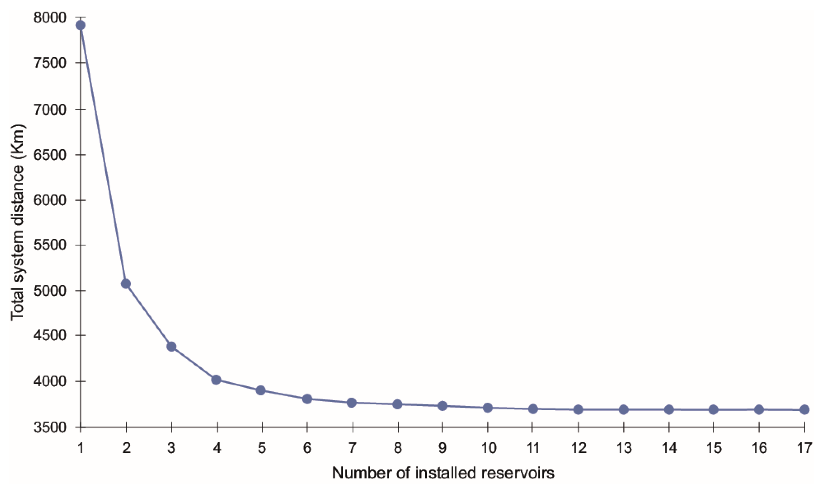
Table 2. Results by placed water reservoir.
Water ReservoirsNumber of Fire Points to Be Supplied [km2]Maximum Distance [km]Average Distance [km]
130016,273.007331.35
21439431.954928.31
315110,047.384968.27
46913,034.265139.63
Disclaimer/Publisher’s Note: The statements, opinions and data contained in all publications are solely those of the individual author(s) and contributor(s) and not of MDPI and/or the editor(s). MDPI and/or the editor(s) disclaim responsibility for any injury to people or property resulting from any ideas, methods, instructions or products referred to in the content.

