
Forest Fire Spread Hazard and Landscape Pattern Characteristics in the Mountainous District, Beijing

Abstract
:1. Introduction
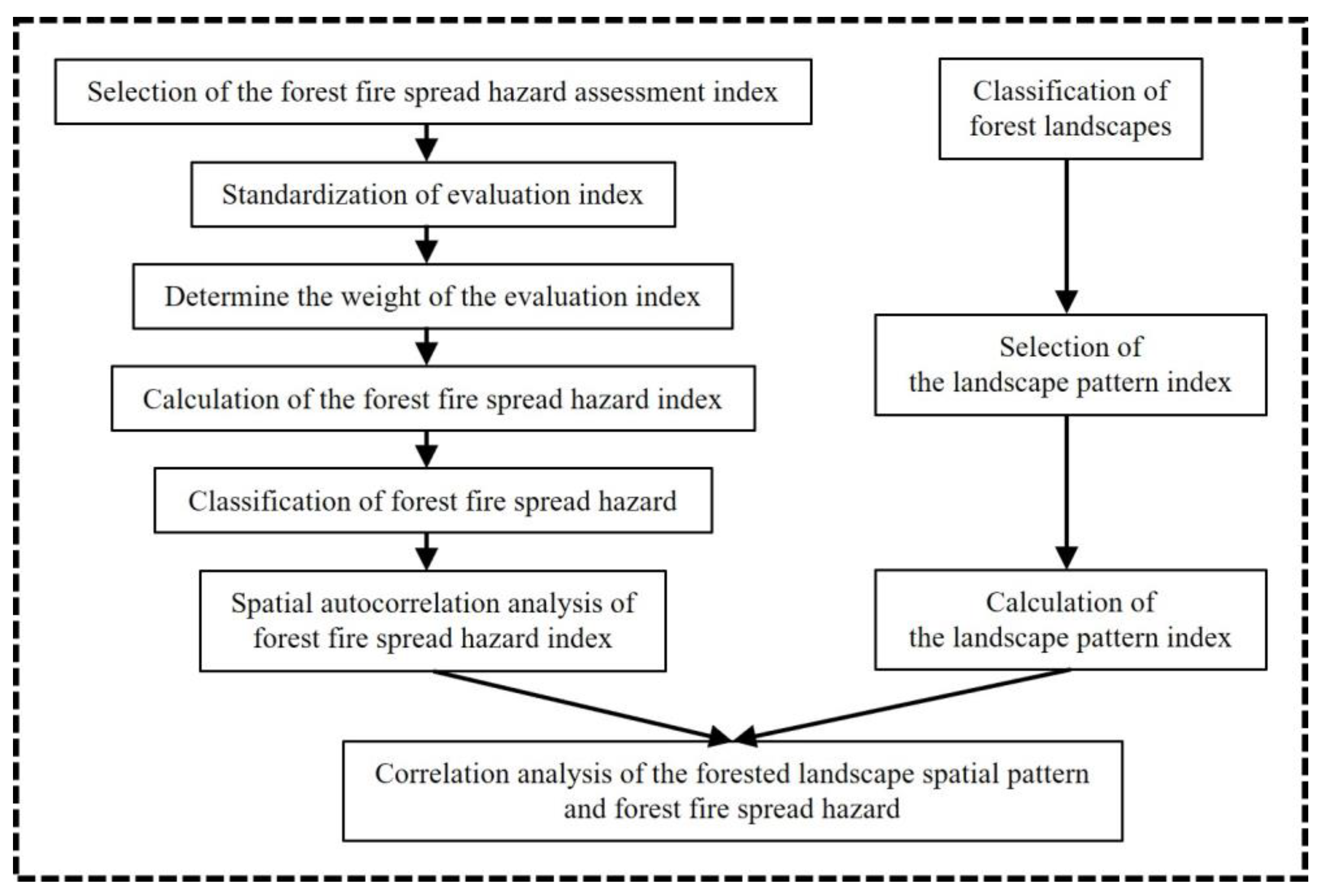
2. Methods
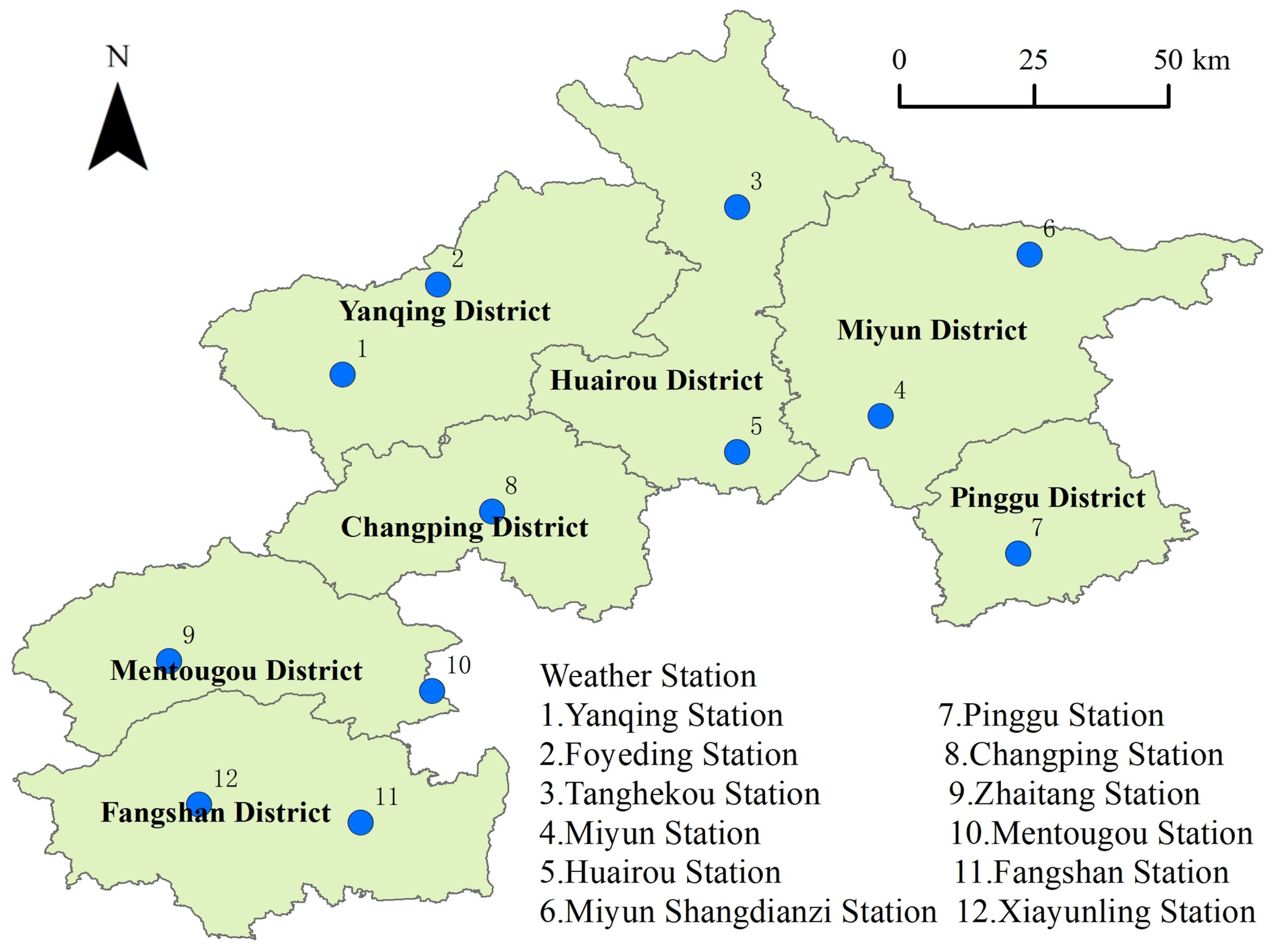
2.1. Study Areas
2.2. Data Sources
2.3. Forest Fire Spread Hazard Assessment
2.3.1. Forest Fire Spread Hazard Assessment Index
2.3.2. Standardization of Evaluation Index
2.3.3. Determine the Weight of the Evaluation Index
2.3.4. Forest Fire Spread Hazard Index Calculation
2.3.5. Forest Fire Spread Hazard Classification
2.3.6. Spatial Autocorrelation Analysis
2.4. Correlation Analysis of the Forest Landscape Spatial Pattern and Forest Fire Spread Hazard
2.4.1. Classification of Forest Landscapes in the Mountainous District of Beijing
2.4.2. Selection and Calculation of the Landscape Pattern Index
2.4.3. Correlation Analysis of the Forested Landscape Spatial Pattern and Forest Fire Spread Hazard
3. Results
3.1. Determination of the Weights of the Forest Fire Spread Hazard Indices
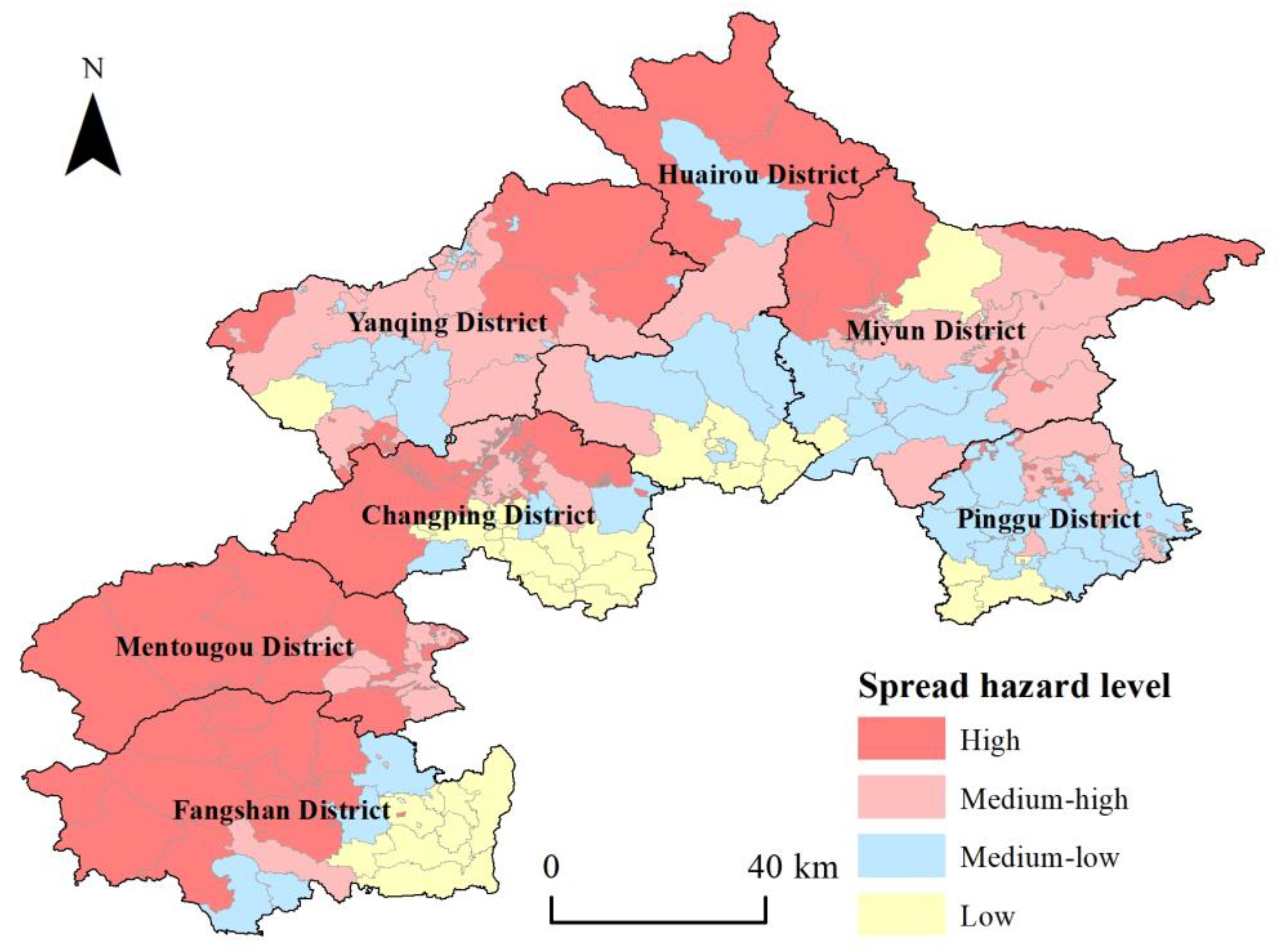
3.2. Forest Fire Spread Hazard Assessment in the Mountainous District, Beijing
3.2.1. Forest Fire Spread Hazard Assessment at the Subcompartment and Township Scales
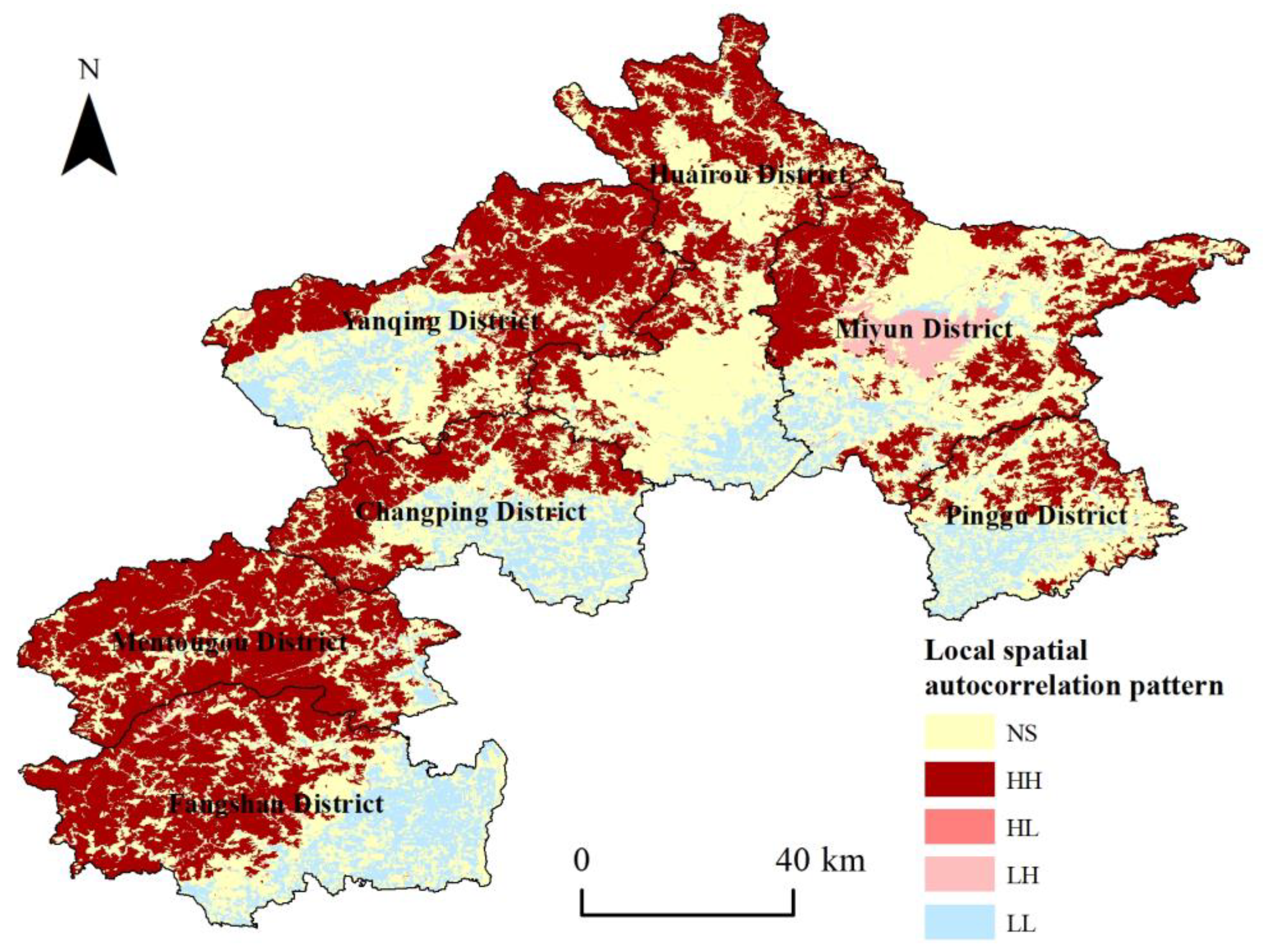
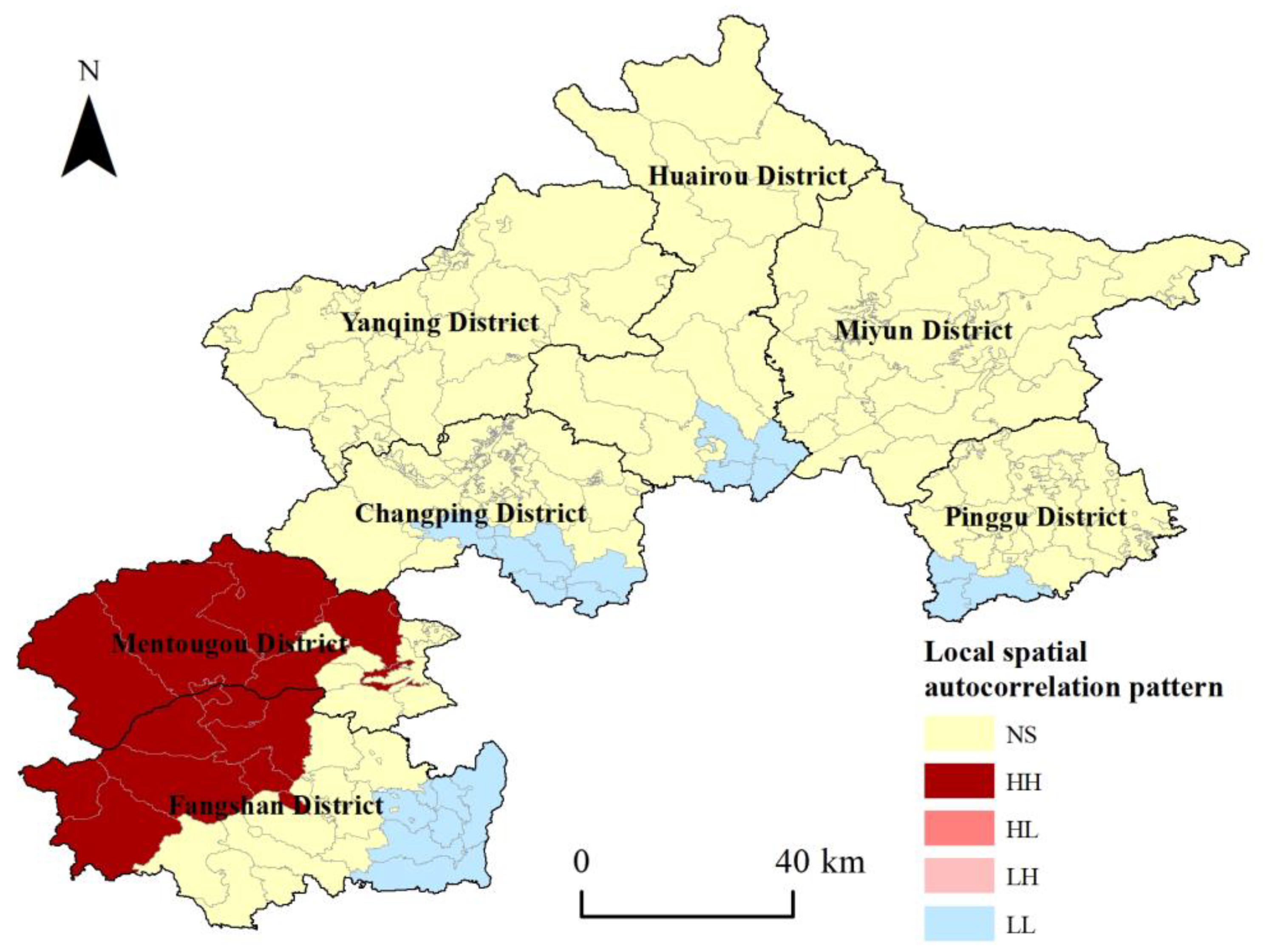
3.2.2. Spatial Autocorrelation of the Forest Fire Spread Hazard
3.3. Correlation Analysis of the Forested Landscape Spatial Pattern and Forest Fire Spread Hazard in the Mountainous District of Beijing
3.3.1. Calculation and Statistics of the Landscape Pattern Index of Townships in the Mountainous District of Beijing
3.3.2. Correlation Analysis between Landscape Spatial Pattern Characteristics and Forest Fire Spread Hazard in the Mountainous District of Beijing
3.3.3. Analysis of the Main Factors Affecting the Forest Fire Spread Hazard
4. Discussion
5. Conclusions
Author Contributions
Funding
Data Availability Statement
Acknowledgments
Conflicts of Interest
References
- Chuvieco, E.; Aguado, I.; Yebra, M.; Nieto, H.; Salas, J.; Martín, M.P.; Vilar, L.; Martínez, J.; Martín, S.; Ibarra, P.; et al. Development of a framework for fire risk assessment using remote sensing and geographic information system technologies. Ecol. Model. 2010, 221, 46–58. [Google Scholar] [CrossRef]
- Hysa, A.; Baskaya, F.A.T. A GIS based method for indexing the broad-leaved forest surfaces by their wildfire ignition probability and wildfire spreading capacity. Model. Earth Syst. Environ. 2019, 5, 71–84. [Google Scholar] [CrossRef]
- Hysa, A.; Spalevic, V.; Dudic, B.; Rosca, S.; Kuriqi, A.; Bilasco, S.; Sestras, P. Utilizing the available open-source remotely sensed data in assessing the wildfire ignition and spread capacities of vegetated surfaces in Romania. Remote Sens. 2021, 13, 2737. [Google Scholar] [CrossRef]
- Hysa, A. Indexing the vegetated surfaces within WUI by their wildfire ignition and spreading capacity, a comparative case from developing metropolitan areas. Int. J. Disaster Risk Reduct. 2021, 63, 102434. [Google Scholar] [CrossRef]
- Hysa, A.; Teqja, Z.; Bani, A.; Libohova, Z.; Cerda, A. Assessing wildfire vulnerability of vegetated serpentine soils in the Balkan peninsula. J. Nat. Conserv. 2022, 68, 126217. [Google Scholar] [CrossRef]
- Guo, Z.X.; Zhong, X.C.; Fang, W.H.; Cao, X.; Lin, W. The research advances of wildfire spreading and wildfire risk assessment. Prog. Geogr. 2010, 29, 778–788. [Google Scholar]
- Francis, E.J.; Pourmohammadi, P.; Steel, Z.L.; Collins, B.M.; Hurteau, M.D. Proportion of forest area burned at high-severity increases with increasing forest cover and connectivity in western US watersheds. Landsc. Ecol. 2023, 38, 2501–2518. [Google Scholar] [CrossRef]
- Aparício, B.A.; Santos, J.A.; Freitas, T.R.; Sá, A.C.L.; Pereira, J.M.C.; Fernandes, P.M. Unravelling the effect of climate change on fire danger and fire behaviour in the Transboundary Biosphere Reserve of Meseta Ibérica (Portugal-Spain). Clim. Chang. 2022, 173, 5. [Google Scholar] [CrossRef]
- Kharuk, V.I.; Shvetsov, E.G.; Buryak, L.V.; Golyukov, A.S.; Dvinskaya, M.L.; Petrov, I.A. Wildfires in the Larch Range within Permafrost, Siberia. Fire 2023, 6, 301. [Google Scholar] [CrossRef]
- Whitman, E.; Parks, S.A.; Holsinger, L.M.; Parisien, M.A. Climate-induced fire regime amplification in Alberta, Canada. Environ. Res. Lett. 2022, 17, 055003. [Google Scholar] [CrossRef]
- Bowman, D.M.J.S.; Williamson, G.J.; Abatzoglou, J.T.; Kolden, C.A.; Cochrane, M.A.; Smith, A.M.S. Human exposure and sensitivity to globally extreme wildfire events. Nat. Ecol. Evol. 2017, 1, 0058. [Google Scholar] [CrossRef] [PubMed]
- Canadell, J.G.; Meyer, C.P.; Cook, G.D.; Dowdy, A.; Briggs, P.R.; Knauer, J.; Pepler, A.; Haverd, V. Multi-decadal increase of forest burned area in Australia is linked to climate change. Nat. Commun. 2021, 12, 6921. [Google Scholar] [CrossRef] [PubMed]
- Ferreira, I.J.M.; Campanharo, W.A.; Barbosa, M.L.F.; Silva, S.S.d.; Selaya, G.; Aragão, L.E.O.C.; Anderson, L.O. Assessment of fire hazard in Southwestern Amazon. Front. For. Glob. Chang. 2023, 6, 1107417. [Google Scholar] [CrossRef]
- Rodrigues, M.; Camprubí, À.C.; Balaguer-Romano, R.; Megía, C.J.C.; Castañares, F.; Ruffault, J.; Fernandes, P.M.; Dios, V.R.d. Drivers and implications of the extreme 2022 wildfire season in Southwest Europe. Sci. Total Environ. 2023, 859, 160320. [Google Scholar] [CrossRef] [PubMed]
- Fryirs, K.A.; Zhang, N.; Duxbury, E.; Ralph, T. Rivers up in smoke: Impacts of Australia’s 2019–2020 megafires on riparian systems. Int. J. Wildland Fire 2022, 31, 720–727. [Google Scholar] [CrossRef]
- Alarcon-Aguirre, G.; Miranda Fidhel, R.F.; Ramos Enciso, D.; Canahuire-Robles, R.; Rodriguez-Achata, L.; Garate-Quispe, J. Burn severity assessment using sentinel-1 SAR in the southeast Peruvian Amazon, a case study of Madre de Dios. Fire 2022, 5, 94. [Google Scholar] [CrossRef]
- Mamuji, A.A.; Rozdilsky, J.L. Wildfire as an increasingly common natural disaster facing Canada: Understanding the 2016 Fort McMurray wildfire. Nat. Hazards 2019, 98, 163–180. [Google Scholar] [CrossRef]
- Canosa, I.V.; Biesbroek, R.; Ford, J.; McCarty, J.L.; Orttung, R.W.; Paavola, J.; Burnasheva, D. Wildfire adaptation in the Russian Arctic: A systematic policy review. Clim. Risk Manag. 2023, 39, 100481. [Google Scholar] [CrossRef]
- United Nations Environment Programme. Spreading like Wildfire—The Rising Threat of Extraordinary Landscape Fires. A UNEP Rapid Response Assessment; United Nations Environment Programme: Nairobi, Kenya, 2022. [Google Scholar]
- Wang, B.; Yang, X.Q.; Jiang, C.Y.; Liu, D.; Chen, F.; Bai, Y.; Liu, X.D. Forest fire spread risk in Yanqing District of Beijing based on GIS. Sci. Silvae Sin. 2023, 59, 90–101. [Google Scholar]
- Nune, A.N.; Figueiredo, A.; Pinto, C.; Lourenço, L. Assessing wildfire hazard in the wildland-urban interfaces (WUIs) of central Portugal. Forests 2023, 14, 1106. [Google Scholar] [CrossRef]
- Xofis, P.; Konstantinidis, P.; Papadopoulos, I.; Tsiourlis, G. Integrating remote sensing methods and fire simulation models to estimate fire hazard in a south-east mediterranean protected area. Fire 2020, 3, 31. [Google Scholar] [CrossRef]
- Wibbenmeyer, M.; Robertson, M. The distributional incidence of wildfire hazard in the western United States. Environ. Res. Lett. 2022, 17, 064031. [Google Scholar] [CrossRef]
- Scott, J.H.; Thompson, M.P.; Calkin, D.E. A Wildfire Risk Assessment Framework for Land and Resource Management; General Technical Reports RMRS-GTR-315; U.S. Department of Agriculture, Forest Service, Rocky Mountain Research Station: Fort Collins, CO, USA, 2013; 83p. [Google Scholar]
- Scott, J.; Helmbrecht, D.; Thompson, M.P.; Calkin, D.E.; Marcille, K. Probabilistic assessment of wildfire hazard and municipal watershed exposure. Nat. Hazards 2012, 64, 707–728. [Google Scholar] [CrossRef]
- Jolly, W.M.; Freeborn, P.H.; Page, W.G.; Butler, B.W. Severe fire danger index: A forecastable metric to inform firefighter and community wildfire risk management. Fire 2019, 2, 47. [Google Scholar] [CrossRef]
- Shafapourtehrany, M. Geospatial wildfire risk assessment from social, infrastructural and environmental perspectives: A case study in Queensland Australia. Fire 2023, 6, 22. [Google Scholar] [CrossRef]
- Zhang, H.; Wang, X.; Zhang, X.; Yu, H.Z.; Zhou, M.; Wang, Y.X. Forest fire danger rating and fire hazard assessment in Chifeng City of Inner Mongolia. J. Southwest For. Univ. 2019, 39, 143–150. [Google Scholar]
- Rodrigues, M.; Zúñiga-Antón, M.; Alcasena, F.; Gelabert, P.; Vega-Garcia, C. Integrating geospatial wildfire models to delineate landscape management zones and inform decision-making in Mediterranean areas. Saf. Sci. 2022, 147, 105616. [Google Scholar] [CrossRef]
- Sá, A.C.L.; Aparicio, B.; Benali, A.; Bruni, C.; Salis, M.; Silva, F.; Marta-Almeida, M.; Pereira, S.; Rocha, A.; Pereira, J. Coupling wildfire spread simulations and connectivity analysis for hazard assessment: A case study in Serra da Cabreira, Portugal. Nat. Hazards Earth Syst. Sci. 2022, 22, 3917–3938. [Google Scholar] [CrossRef]
- Calkin, D.E.; Ager, A.A.; Gilbertson, D.J. Wildfire risk and hazard: Procedures for the first approximation. In General Technical Report RMRS-GTR-235; U.S. Department of Agriculture, Forest Service, Rocky Mountain Research Station: Fort Collins, CO, USA, 2010; p. 62. [Google Scholar]
- Tao, C.S.; Niu, S.K.; Chen, F.; Li, L.Q.; Chen, L.; Zhang, P. Potential fire behavior and canopy hazard index of main coniferous forests in Beijing mountain area. J. Beijing For. Univ. 2018, 40, 55–62. [Google Scholar]
- Aparício, B.A.; Pereira, J.M.C.; Santos, F.C.; Bruni, C.; Sá, A.C.L. Combining wildfire behaviour simulations and network analysis to support wildfire management: A Mediterranean landscape case study. Ecol. Indic. 2022, 137, 108726. [Google Scholar] [CrossRef]
- Loehman, R.A.; Keane, R.E.; Holsinger, L.M.; Wu, Z.W. Interactions of landscape disturbances and climate change dictate ecological pattern and process: Spatial modeling of wildfire, insect, and disease dynamics under future climates. Landsc. Ecol. 2017, 32, 1447–1459. [Google Scholar] [CrossRef]
- Pais, C.; Miranda, A.; Carrasco, J.; Shen, Z.J.M. Deep fire topology: Understanding the role of landscape spatial patterns in wildfire occurrence using artificial intelligence. Environ. Model. Softw. 2021, 143, 105122. [Google Scholar] [CrossRef]
- Hood, S.M.; Varner, J.M.; Jain, T.B.; Kane, J.M. A framework for quantifying forest wildfire hazard and fuel treatment effectiveness from stands to landscapes. Fire Ecol. 2022, 18, 33. [Google Scholar] [CrossRef]
- Shi, K.; Touge, Y. Characterization of global wildfire burned area spatiotemporal patterns and underlying climatic causes. Sci. Rep. 2022, 12, 644. [Google Scholar] [CrossRef] [PubMed]
- Lee, J.; Kim, J.; Shin, J.; Cho, S.; Kim, S.; Lee, K. Analysis of wildfires and their extremes via spatial quantile autoregressive model. Extremes 2023, 26, 353–379. [Google Scholar] [CrossRef]
- Tomar, J.S.; Kranjčić, N.; Đurin, B.; Kanga, S.; Singh, S.K. Forest fire hazards vulnerability and risk assessment in sirmaur district forest of Himachal Pradesh (India): A Geospatial Approach. ISPRS Int. J. Geo-Inf. 2021, 10, 447. [Google Scholar] [CrossRef]
- He, Y.N.; Chen, G.; Cobb, R.C.; Zhao, K.G.; Meentemeyer, R.K. Forest landscape patterns shaped by interactions between wildfire and sudden oak death disease. For. Ecol. Manag. 2021, 486, 118987. [Google Scholar] [CrossRef]
- Ghadban, S.; Ameztegui, A.; Rodrigues, M.; Chocarro, C.; Alcasena, F.; Vega-Garcia, C. Stand structure and local landscape variables are the dominant factors explaining shrub and tree diversity in Mediterranean forests. Sustainability 2021, 13, 11658. [Google Scholar] [CrossRef]
- Long, T.T.; Yin, J.Y.; Ou, C.R.; Yang, Q.; Li, Y.; Wang, Q.H. Comprehensive assessment and spatial pattern study on forest fire risk in Yunnan Province. China Saf. Sci. J. 2021, 31, 167–173. [Google Scholar]
- Zhang, H.; Qiao, G.W.; Zhang, Q.L. Studies on periodicity variation of forest and grassland fires in China based on wavelet analysis. J. For. Eng. 2019, 4, 139–145. [Google Scholar]
- Steel, Z.L.; Koontz, M.J.; Safford, H.D. The changing landscape of wildfire: Burn pattern trends and implications for California’s yellow pine and mixed conifer forests. Landsc. Ecol. 2018, 33, 1159–1176. [Google Scholar] [CrossRef]
- Benali, A.; Sá, A.C.L.; Pinho, J.; Fernandes, P.M.; Pereira, J.M.C. Understanding the impact of different landscape-level fuel management strategies on wildfire hazard in central Portugal. Forests 2021, 12, 522. [Google Scholar] [CrossRef]
- Adab, H.; Atabati, A.; Oliveira, S.; Gheshlagh, A.M. Assessing fire hazard potential and its main drivers in Mazandaran province, Iran: A data-driven approach. Environ. Monit. Assess. 2018, 190, 670. [Google Scholar] [CrossRef] [PubMed]
- Niu, S.K.; Cui, G.F.; Lei, M.; Li, X.B.; Zhao, S.T. Study on the forest combustibility and the fire districts in Labagoumen forest region. J. Beijing For. Univ. 2000, 22, 109–112. [Google Scholar]
- Wang, X.L. Study on Combustibility of Forests in Beijing Mountain Area. Ph.D. Thesis, Beijing Forestry University, Beijing, China, 2010. [Google Scholar]
- Xu, S.H.; Zhang, M.; Ma, Y.; Liu, J.P.; Wang, Y.; Ma, X.R.; Chen, J. Multiclassification method of landslide risk assessment in consideration of disaster levels: A case study of Xianyang city, Shaanxi Province. ISPRS Int. J. Geo-Inf. 2021, 10, 646. [Google Scholar] [CrossRef]
- Nasiri, V.; Sadeghi, S.M.M.; Bagherabadi, R.; Moradi, F.; Deljouei, A.; Borz, S.A. Modeling wildfire risk in western Iran based on the integration of AHP and GIS. Environ. Monit. Assess. 2022, 194, 644. [Google Scholar] [CrossRef]
- Xiang, K.X.; Zhou, Y.; Zhou, E.Z.; Lu, J.H.; Liu, H.; Huang, Y. A spatial assessment of wildfire risk for transmission-line corridor based on a weighted naïve bayes model. Front. Energy Res. 2022, 10, 829934. [Google Scholar] [CrossRef]
- Li, X.H.; Li, M.J.; Cui, K.K.; Lu, T.; Xie, Y.L.; Liu, D.L. Evaluation of comprehensive emergency capacity to urban flood disaster: An example from Zhengzhou city in Henan Province, China. Sustainability 2022, 14, 13710. [Google Scholar] [CrossRef]
- Bian, R.; Huang, K.Y.; Liao, X.; Ling, S.X.; Wen, H.; Wu, X.Y. Snow avalanche susceptibility assessment based on ensemble machine learning model in the central Shaluli Mountain. Front. Earth Sci. 2022, 10, 880711. [Google Scholar] [CrossRef]
- Baek, S.; Yoon, H.; Hahm, Y. Assessment of spatial interactions in farmland abandonment: A case study of Gwangyang city, Jeollanam-do Province, South Korea. Habitat Int. 2022, 129, 102670. [Google Scholar] [CrossRef]
- Fard, B.J.; Puvvula, J.; Bell, J.E. Evaluating changes in health risk from drought over the contiguous United States. Int. J. Environ. Res. Public Health 2022, 19, 4628. [Google Scholar] [CrossRef] [PubMed]
- Asubonteng, K.O.; Pfeffer, K.; Ros-Tonen, M.A.F.; Baud, I.; Benefoh, D.T. Integration versus segregation: Structural dynamics of a smallholder-dominated mosaic landscape under tree-crop expansion in Ghana. Appl. Geogr. 2020, 118, 102201. [Google Scholar] [CrossRef]
- Zhang, C.; Niu, S.K.; Chen, F.; Shao, X.; Wang, H. Effect of landscape pattern on forest fires in Yunnan province based on GIS. Sci. Silvae Sin. 2016, 52, 96–103. [Google Scholar]
- Chen, L. Study on Pattern of Landscape Security and Fire Hazard in Miaofeng Mountain Forests. Master Thesis, Beijing Forestry University, Beijing, China, 2019. [Google Scholar]
- Chen, Y.Y.; You, Y.S.; Tang, Y.H. Research of forest fire zoning based on local topography and fire numbers. J. Nat. Disasters 2015, 24, 228–234. [Google Scholar]
- Li, L.Q.; Niu, S.K.; Chen, F.; Tao, C.S.; Chen, L.; Zhang, P. Analysis on surface potential fire behavior and combustion of Miaofeng Mountain Forest Farm in Beijing. J. Beijing For. Univ. 2019, 41, 58–67. [Google Scholar]
- Liu, G.H. Study on the Mechanism of Surface Fire and Spread of Canopy Fire of Typical Tree Species in Beijing Area. Master’s Thesis, Beijing Forestry University, Beijing, China, 2019. [Google Scholar]
- Wu, J.R.; Chen, X.L.; Lu, J.Z. Assessment of long and short-term flood risk using the multi-criteria analysis model with the AHP-Entropy method in Poyang Lake basin. Int. J. Disaster Risk Reduct. 2022, 75, 102968. [Google Scholar] [CrossRef]
- Li, X.N.; Shao, X.H.; Li, R.Q.; Gao, C.; Yang, X.; Ding, F.Z.; Yuan, Y.B. Optimization of tobacco water-fertilizer coupling scheme under effective microorganisms biochar-based fertilizer application condition. Agron. J. 2021, 113, 1653–1663. [Google Scholar] [CrossRef]
- Zhang, L.; Huo, Z.G.; Zhang, L.Z.; Huang, D.P. Integrated risk assessment of major meteorological disasters with paprika pepper in Hainan province. J. Trop. Meteorol. 2017, 23, 334–344. [Google Scholar]
- Zhang, X.H.; Liu, H.J.; Xu, M.M.; Mao, C.Y.; Shi, J.Q.; Meng, G.L.; Wu, J.H. Evaluation of passenger satisfaction of urban multi-mode public transport. PLoS ONE 2020, 15, e0241004. [Google Scholar] [CrossRef]
- Jenkins, M.J.; Page, W.G.; Hebertson, E.G.; Alexander, M.E. Fuels and fire behavior dynamics in bark beetle-attacked forests in Western North America and implications for fire management. For. Ecol. Manag. 2012, 275, 23–34. [Google Scholar] [CrossRef]
- Yang, X.Q.; Sun, Z.C.; Chai, Z.; Qiu, Y.W.; Jiang, C.Y. Research on the plot survey and load estimation of national forest fuels. For. Resour. Manag. 2022, 6, 1–6. [Google Scholar]
- Heisig, J.; Olson, E.; Pebesma, E. Predicting wildfire fuels and hazard in a central European temperate forest using active and passive remote sensing. Fire 2022, 5, 29. [Google Scholar] [CrossRef]
- Niu, S.K. Fire Behavior and Fuel Spatial Continuity of Major Forest Types in the Mountainous Area. Ph.D. Thesis, Beijing Forestry University, Beijing, China, 2012. [Google Scholar]
- Deng, X.W.; Wen, D.Y.; Deng, S.W. A preliminary study of the relationship between forest fire and landscape pattern. Fire Saf. Sci. 2003, 12, 238–244+255. [Google Scholar]
- Chen, L.; Chen, F.; Niu, S.K.; Li, L.Q.; Tao, C.S. Correlation analysis between the spatial characteristics of landscape pattern and risk of forest fire in Jiufeng Forest Park of Beijing. J. Beijing For. Univ. 2021, 43, 41–49. [Google Scholar]
- Tian, X.R.; Dai, X.A.; Wang, M.Y.; Shu, L.F.; Gao, C.D. Study on the fuel types classification of forests in Beijing. Sci. Silvae Sin. 2006, 42, 76–80. [Google Scholar]


| Primary Index | Secondary Index | Calculation/Unit |
|---|---|---|
| Forest fuel | Surface fuel load | Amount of surface fuel (shrub, herb, and litter) per unit area, in t/hm2. |
| Total coverage of shrub and grass vegetation | Total coverage of the shrub and grass layer in the forested land, in %. | |
| Forest flammability | How easy it is for the forest to catch fire, and the state of burning (fire type), burning speed, and fire intensity. Can also measure the amount of energy released by burning forests, without dimensionality. | |
| Meteorological factors | Monthly gale days during the fire prevention period | During the fire prevention period, the monthly average number of weather days with instantaneous wind force 5 or above, in days. |
| Monthly precipitation during the fire prevention period | The monthly average total rainfall during the fire prevention period, in mm. | |
| Monthly mean maximum temperature during the fire prevention period | Average daily maximum temperature during the fire prevention period, in °C. | |
| Topographical factors | Elevation | The vertical distance above sea level, in m. |
| Slope | The ratio of the vertical height to the horizontal width of a slope, in °. | |
| Aspect | Orientation of slope, without dimensionality. | |
| Slope position | The landform on which a slope is located, without dimensionality. | |
| Fire behavior | Surface fire spread speed | The distance that the surface fire line moves forward per unit time, in m·min−1. |
| Fireline intensity | Heat release rate per unit length of fire head front, in kW·m−1. | |
| Flame height | Continuous flame height perpendicular to the ground, in m. |
| Primary Index | Comprehensive Weight of Primary Index | Secondary Index | Chromatography Analysis Weight of Secondary Index | Entropy Weight of Secondary Index | Comprehensive Weight of Secondary Index |
|---|---|---|---|---|---|
| Forest fuel | 0.1909 | Surface fuel load | 0.0812 | 0.0404 | 0.0608 |
| Total coverage of shrub and grass vegetation | 0.1132 | 0.0598 | 0.0865 | ||
| Forest flammability | 0.0735 | 0.0137 | 0.0436 | ||
| Meteorological factors | 0.1434 | Monthly gale days during the fire prevention period | 0.1153 | 0.0405 | 0.0779 |
| Monthly precipitation during the fire prevention period | 0.0524 | 0.0210 | 0.0367 | ||
| Monthly mean maximum temperature during the fire prevention period | 0.0501 | 0.0075 | 0.0288 | ||
| Topographical factors | 0.2520 | Elevation | 0.0126 | 0.0038 | 0.0082 |
| Slope | 0.1249 | 0.1813 | 0.1531 | ||
| Aspect | 0.0508 | 0.0384 | 0.0446 | ||
| Slope position | 0.0522 | 0.0400 | 0.0461 | ||
| Fire behavior | 0.4137 | Surface fire spread speed | 0.1265 | 0.2103 | 0.1684 |
| Fireline intensity | 0.0781 | 0.2103 | 0.1442 | ||
| Flame height | 0.0692 | 0.1330 | 0.1011 |
| Index | Moran’s I index | Z | P |
|---|---|---|---|
| Forest fire spread hazard index at the subcompartment scale | 0.6057 | 464.6000 | 0.0000 |
| Forest fire spread hazard index at the township scale | 0.4978 | 10.1603 | 0.0000 |
| Landscape Pattern Index | Maximum Value | Median Value | Minimum Value | Average Value | Standard Deviation | Coefficient of Variation (%) |
|---|---|---|---|---|---|---|
| TA | 37,349.8000 | 6509.9800 | 6.3900 | 8566.7259 | 7671.0216 | 89.5444 |
| NP | 3383.0000 | 585.0000 | 2.0000 | 706.6950 | 637.0348 | 90.1428 |
| PD | 32.3600 | 8.3113 | 0.6205 | 9.4364 | 6.2420 | 66.1485 |
| LPI | 99.7673 | 25.4143 | 5.1456 | 36.2719 | 25.4719 | 70.2249 |
| LSI | 38.8390 | 18.8652 | 1.3347 | 18.7565 | 8.8651 | 47.2640 |
| CONTAG | 98.4728 | 55.6657 | 0.0000 | 57.9148 | 11.1045 | 19.1739 |
| DIVISION | 0.9844 | 0.8930 | 0.0046 | 0.7822 | 0.2341 | 29.9263 |
| PR | 6.0000 | 6.0000 | 1.0000 | 5.6950 | 0.8940 | 15.6974 |
| PRD | 31.2989 | 0.0922 | 0.0161 | 0.4907 | 2.7369 | 557.7276 |
| SHDI | 1.7504 | 1.3755 | 0.0000 | 1.2532 | 0.3599 | 28.7155 |
| AI | 99.7948 | 96.1721 | 91.3310 | 96.1040 | 1.3874 | 1.4437 |
| Landscape Pattern Index | TA | NP | PD | LPI | LSI | CONTAG | DIVISION | PR | PRD | SHDI | AI |
|---|---|---|---|---|---|---|---|---|---|---|---|
| Correlation coefficient | 0.358 ** | 0.016 | −0.614 ** | −0.550 ** | 0.045 | −0.204 * | 0.488 ** | 0.005 | −0.175 * | 0.357 ** | 0.426 ** |
| Index | First Principal Components | Second Principal Components | Third Principal Components | |
|---|---|---|---|---|
| Load matrix | TA | 0.185 | 0.480 | 0.319 |
| PD | 0.309 | −0.629 | ||
| CONTAG | −0.508 | −0.148 | −0.324 | |
| PRD | −0.176 | −0.397 | 0.839 | |
| SHDI | 0.546 | 0.268 | 0.127 | |
| AI | −0.532 | 0.350 | 0.271 | |
| Contribution rate | Variance root extraction of principal component | 1.526 | 1.308 | 0.957 |
| Variance contribution rate | 0.388 | 0.285 | 0.153 | |
| Cumulative variance contribution rate | 0.388 | 0.673 | 0.826 |
Disclaimer/Publisher’s Note: The statements, opinions and data contained in all publications are solely those of the individual author(s) and contributor(s) and not of MDPI and/or the editor(s). MDPI and/or the editor(s) disclaim responsibility for any injury to people or property resulting from any ideas, methods, instructions or products referred to in the content. |
© 2023 by the authors. Licensee MDPI, Basel, Switzerland. This article is an open access article distributed under the terms and conditions of the Creative Commons Attribution (CC BY) license (https://creativecommons.org/licenses/by/4.0/).
Share and Cite
Wang, B.; Li, W.; Lai, G.; Chang, N.; Chen, F.; Bai, Y.; Liu, X. Forest Fire Spread Hazard and Landscape Pattern Characteristics in the Mountainous District, Beijing. Forests 2023, 14, 2139. https://doi.org/10.3390/f14112139
Wang B, Li W, Lai G, Chang N, Chen F, Bai Y, Liu X. Forest Fire Spread Hazard and Landscape Pattern Characteristics in the Mountainous District, Beijing. Forests. 2023; 14(11):2139. https://doi.org/10.3390/f14112139
Chicago/Turabian StyleWang, Bo, Weiwei Li, Guanghui Lai, Ning Chang, Feng Chen, Ye Bai, and Xiaodong Liu. 2023. "Forest Fire Spread Hazard and Landscape Pattern Characteristics in the Mountainous District, Beijing" Forests 14, no. 11: 2139. https://doi.org/10.3390/f14112139
APA StyleWang, B., Li, W., Lai, G., Chang, N., Chen, F., Bai, Y., & Liu, X. (2023). Forest Fire Spread Hazard and Landscape Pattern Characteristics in the Mountainous District, Beijing. Forests, 14(11), 2139. https://doi.org/10.3390/f14112139