Article

GIS-AHP Approach in Forest Logging Planning to Apply Sustainable Forest Operations

1
Consiglio per la Ricerca in Agricoltura e l’Analisi dell’Economia Agraria (CREA), Centro di Ricerca Ingegneria e Trasformazioni Agroalimentari, Via della Pascolare 16, 00015 Monterotondo, Italy
2
Department of Agriculture, Forests, Nature and Energy, Tuscia University, DAFNE, Viterbo-Italy, Via San Camillo de Lellis, 01100 Viterbo, Italy
*
Author to whom correspondence should be addressed.
Forests 2022, 13(3), 484; https://doi.org/10.3390/f13030484
Submission received: 23 February 2022 / Revised: 14 March 2022 / Accepted: 18 March 2022 / Published: 21 March 2022

Abstract

:
This study represents the first attempt of integration, within a Forest Management Plan (FMP), of a Geographic Information System (GIS) and an Analytic Hierarchy Process (AHP) approach for the selection of the most suitable logging method. It is important to underline that the developed methodology is applicable worldwide in each environmental context in which there is a need for planning the intervention and selecting from among several possible logging methods or harvesting systems. Schematically, the main aims of this study were: (i) to develop a GIS-AHP method based on open-access GIS software; (ii) to compare the results of the simulations developed from the statements of two different groups of experts from around the world, to determine the reliability of the predictive probability of the method. The selection of the extraction methods performed with RTS (experts from research and technical sector) input data showed that the most suitable option in the major part of the study area was the cable skidder, followed by the cable yarder, and finally the forwarder. The extraction system selection performed with OS (people from the operative sector) input data revealed limited differences. Thus, considering what was reported above, it is possible to assert that the applied GIS-AHP methodology showed good performance and high consistency in the selection of the best alternatives among different extraction methods. The idea of comparing the results obtained from a survey based on a pool of researchers and forest engineers (RTS) was taken as a target simulation to be evaluated. The method based on data derived from a pool of expert forest operators (OS) was used to check for the results of the other simulation. This is an innovation in these kinds of studies. The results from the consistency check were encouraging, considering that for 51 sub-compartments, only two changed the selected extraction system between RTS and OS.

1. Introduction

Land use and land management are key topics in the international debates for environmental policies which take into account the protection of the environment and the public demand for forest products [1]. Furthermore, the growing public awareness on sustainable exploitation of the natural resources is fostering the expectation on scholars and forest engineers for a better management of such resources. This implies a broader view on the possible critical aspects related to the forest management sector [2].
The key instrument for forest management is the Forest Management Plan (FMP), which consists of a recommended action plan for a given medium-large forest area [3]. The usual time span is in the range between 5 and 20 years.
Typically, the FMP should schedule multiple aspects related to environmental and forest management, encompassing several activities which stretch from silviculture to road construction, also including forest logging [4]. Currently, forest planning should meet the goal of Sustainable Forest Management (SFM); therefore, FMP should be addressed to develop a management which safeguards each of the three pillars of sustainability (economy, society and environment) [5,6,7]. A proper planning of the forest activities is a crucial issue in the context of SFM [8,9].
Among the several aspects which a modern FMP should thus include, a key role is related to the proper planning of the harvesting activities by implementing Sustainable Forest Operations (SFOs) and following best practices as Reduced Impact Logging (RIL) approaches [10,11]. The SFO concept consists of the implementation of harvesting operations which allow for high work productivity (i.e., low costs), low environmental impacts and safe working conditions for the operators [12]. According to the above, identifying the most suitable harvesting system in forest operations is a challenging but crucial issue [13,14,15]. Several aspects have some influence on the decision regarding the harvesting system to be applied in a given forest intervention, and among them, there are stand and terrain characteristics, management goals, accessible technology, and forest infrastructure [16]. Multi Criteria Decision Analysis (MCDA) is a group of several methods which were developed to enable the analysis of situations based on decisions that require multiple criteria [3]. MCDA is usually applied to deal with planning situations in which there is the need to holistically evaluate different decision alternatives [17,18]. Several MCDA methods can be applied in natural resources management, but among them, the Analytic Hierarchy Process (AHP) [19] has been the most applied in the forest management sector [14]. The AHP method allows for the decomposition of a complex problem into a hierarchy, where the goal is at the top level, while criteria and alternatives are the lower levels. This method determines the preferences among several alternatives by applying a pairwise comparison of the elements [14]. The potential of AHP is even higher when it is applied along with technologies related to the Precision Forest Harvesting approach [20]. In particular, the combined application of GIS (Geographic Information System) and AHP has been found to be an interesting way to deal with the issue of managing forest resources from an objective approach [16,21,22].
However, there are still two major concerns regarding such methodology in the planning of logging activities. The first one is related to the scarce practical application of this methodology, mostly related to the “lack of interaction” between researchers and technicians, an aspect which is rather common in the forestry sector [23].
Apart from some exceptions [24], the application of such methods in the operational part of FMPs is still far from a practical implementation. Moreover, in some cases, the forest harvesting planning and related forest operations, in particular concerning bunching and extraction, is practically absent from the FMP, and the decision regarding the harvesting system is often postponed to the moment of the implementation of the intervention. This is particularly true for the Mediterranean forest sector, which is mostly based on the system of selling the standing timber [25].
The second aspect which still represents an issue to be tackled in scientific studies dealing with the GIS-AHP approach to forest harvesting planning is the objective difficulty in the evaluation of the results of the prediction. In studies related to the GIS-AHP approach in natural resources management, checking for the consistency of the results can be performed in different ways, such as sensitivity analysis [26], field surveys [27] and remote sensing [28]. Currently, sensitivity analysis is a reliable and widely accepted tool, although it represents another simulation. Therefore, it is difficult to evaluate the results of the prediction of the best harvesting system in a given situation. The base idea of comparing the results of the simulation with the harvesting system which will be actually selected for the implementation of the forest yard could not be a reliable solution for checking the consistency of the predictions. Therefore, there is usually no proof that the harvesting system actually applied is the best option in that specific context.
According to what is written above, this study represents the first attempt of integration within an FMP of a GIS-AHP approach for the selection planning of the best logging method for each sub-compartment of the study area, while trying to tackle the issues reported above.
In particular, the need to expand the practical application of this approach has encouraged authors to develop a methodology to provide the forest engineers with a user-friendly tool which is based on the usage of open-source software and medium-sized hardware. Although the accuracy of open-source GIS software has already been stated [29], only a few operations have relied on it for forest logging applications [9,30,31]. It is important to underline that the developed methodology should be applicable worldwide in each environmental context in which there is the need for planning the intervention by selecting from among several possible logging methods or harvesting systems.
In summary, the objectives of this study were: (i) to develop a GIS-AHP method based on open-access GIS software which allows for the selection of the most suitable option among different extraction methods for forest operations in a mountainous context, while keeping in consideration the parameters of the pillars of sustainability; (ii) to compare the results of the simulations developed from the statements of two different groups of experts from around the world, to determine the reliability of the predictive probability of the method.

2. Materials and Methods

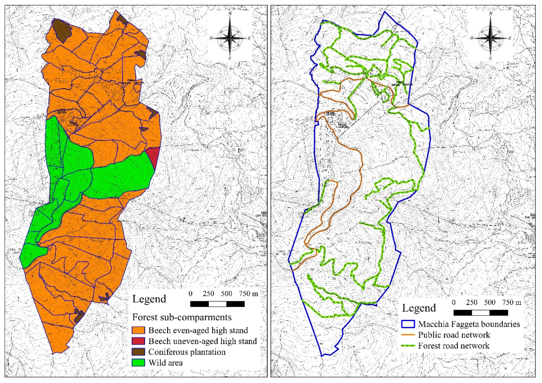
2.1. Study Area and Definition of the Extraction Systems to Be Taken into Consideration

The study area corresponds to the private forest estate of Macchia Faggeta Company, located in the region of Tuscany in Italy. The overall surface of the estate covers 565 ha and is subdivided into 65 sub-compartments. The most represented species is beech (Fagus sylvatica L.), but there are also some silver fir (Abies alba Mill.), Douglas-fir (Pseudotsuga menziesii Mirb.), black pine (Pinus nigra Arn.), and Norway spruce (Picea abies (L.) Karst) artificial plantations. Beech forest represents 98% of the study area, while overall softwood stands comprise the remaining 2%.
The forest stand, both softwood and hardwood, in the study area are for the greater part even-aged high stand, and the applied silviculture treatment is the shelterwood system. It is important to mention that there is a permanent no-intervention area named the wild area. This zone consists of high stands of beech which are deliberately designed as permanent no-intervention areas by the Macchia Faggeta forest managers so as to allow for the natural development of the zone. It is also important to mark that the identification of the most suitable extraction method was carried out for only 51 sub-compartments, excluding the twelve parcels belonging to the wild area and two other small sub-compartments. The surface area in which the extraction system selection was simulated measured 449.91 ha.
Concerning road types involved in the analysis, secondary roads for trucks, skid roads, and permanent skid trails were taken into consideration to build the forest road network. Public main roads (i.e., roads used for the normal traffic of cars) were not included in the forest road network, considering that these roads cannot be used for logging activities according to Italian laws.
A view of the study area boundaries, forest typologies, and forest road network is given in Figure 1.
The study area is located in a Mediterranean mountainous context, and as previously stated, the major part of the surface consists of hardwood stands managed with the shelterwood system. Taking into account these aspects, the authors considered only motor-manual felling and processing by chainsaw, a common choice in hardwood stands mostly used in the Mediterranean areas [32]. The analysis was therefore focused on different extraction methods which are suitable to a mountainous context. These methods are currently applied or have potential to be introduced into practice in this and similar contexts. We took into consideration two ground-based extraction systems (i.e., forwarder and cable skidder) and one aerial extraction system (medium cable yarder). Previous studies have demonstrated the suitability of these systems in extraction operations in similar working conditions [9,30,31].

2.2. Literature Review of Criteria Selection

Selecting the most suitable extraction method in forest operations is a complex task, as there are several parameters which contribute to making a specific system suitable or not in a given context. The different types of variables to be taken into account for the proper selection of the extraction method should be related to the topographical features of the intervention area, to the applied silvicultural treatment, to the forest infrastructures which are present (i.e., roads, landing sites, etc.) and to the characteristics of the forest stand. A literature review of scientific papers in the topic of harvesting operations identified six different criteria which were considered for the analysis carried out in the present work. In particular, the authors considered: slope, extraction distance, soil bearing capacity, extracted timber amount, road density, and roughness. The summary of the various criteria, with the specification of the aspects of sustainability (economy, environment and society) in which they have their influence, is given in Table 1.
Terrain slope is one of the most important parameters to be taken into consideration when planning forest intervention [33,34,35,36]. As a general rule, ground-based extraction systems perform better in lower slope, while cable yarders in steeper terrains [16]. As reported in Table 1, however, slope not only affects work productivity but also the environment and social aspects. Regarding the environment, previous studies have shown that logging in steep slope via ground-based systems led to higher soil compaction and reduced growth of seedlings [37,38]. Focusing instead on worker safety, it is important to underline the fact that applying ground-based extraction in terrains with excessive slope could increase risks of accident during the movement of the machineries [9].
Extraction distance is defined as the distance between the logs to be extracted and the nearest forest road [39]. Several studies have focused on the analysis of the influence of extraction distance on work productivity, revealing the strong influence of this parameter on the cost effectiveness of forest interventions [40,41,42]. In this case however, the implications of such a criterion on the sustainability of the intervention is not limited only to economic aspects, considering dealing with ground-based extraction or aerial extraction with logs in partial suspension, a higher extraction distance implies a higher level of disturbance to soil [43,44] and harsher working conditions for the operators [30]. Similar considerations can be made regarding road density, which is defined as the ratio between the length of the forest roads usable for timber extraction from one forest parcel and the surface of the same parcel [45,46]. High road density is generally related to higher work productivity, mostly dealing with ground-based extraction systems [47]. Conversely, the presence of a proper road density is related to safer working conditions for the operators [9], while focusing on the environmental aspects, an increase in this parameter has been considered as an indicator of the magnitude of disturbance triggered by forest operations of soil [9,30].
Soil bearing capacity is another key factor in the selection of a proper extraction system [16]. The lower value of soil bearing capacity limits the possibility of the application of ground-based extraction systems, increasing the impacts on forest soil, decreasing work productivity, and enhancing the risks of accidents [48,49,50,51].
Roughness is another parameter which has a strong influence on ground-based extraction, and it is recognized as one of the most important limiting factors regarding forest operations in mountainous contexts [52,53]. High roughness limits the movement of forestry machines, decreasing work productivity, and it could lead to a higher level of accident risk.
Finally, another criterion to be taken into consideration when planning forest operations is the extractable timber amount. This variable is mainly related to the cost-effectiveness of the logging activity. As a general rule, the higher the extracted volume the higher the work productivity [16,54].

2.3. Data Collection and Criteria Scoring

After the identification of the criteria for the selection of the extraction method, it was needed to obtain data regarding each criterion for the study area to set up the GIS-AHP methodology and to identify the best alternative for each forest sub-compartment. The GIS software applied for the required analysis was the open-source Quantum GIS ver. 3.16. A personal computer with processor Intel Core i5 2.20 GHz, a graphics processing unit (GPU) NVIDIA GeForge310, and 8.0 Gb RAM was used for the study. The minimum system and hardware requirements for the software are: Core i3 2.7 GHz Processor, 1 Gb Graphic card, 2 Gb Memory RAM, and Windows 7–10 OS [55].
Slope map for the study area was developed starting from a free regional DTM (Digital terrain Model) at 10 m resolution downloaded from the regional geographic data website [56]. Data regarding the forest road network, the details of the estimated extracted timber amount (derived from the forest inventory at the base of the FMP) and the roughness of each sub-compartment were derived from the Forest Management Plan of Macchia Faggeta. Starting from the vector file of the forest road network, it was possible to calculate the extraction distance as a topographic distance applying the RDBM (Real Distance Buffer Method) developed and successfully tested in previous research [30,31].
Finally, data regarding soil bearing capacity were obtained through specific field survey. The field data were collected in spring 2020 from 600 sampling plots (about one for hectare) randomly selected on each hectare of the study area. The location of each plot was determined using a high precision GPS device, and starting from the sample plot centre, three sampling points were selected, one fifty meters away moving up along the maximum slope, and two 50 m away from the centre moving down along the maximum slope but shifted 45° to the right and left. In every sampling point, stiffness and bearing capacity were measured using a portable light falling weight deflectometer (FWD). The FWD was used to evaluate the physical properties of the soil [57,58]; the FWD used was a TERRATEST® 4000 (standard ASTM E2835-11, accelerometer with fix falling height, stress 7.07 kN, falling weights 10 kg and load plate diameter 300 mm). The values of the obtained data were then used to derive descriptive mean values of each individual particle. The map of terrain roughness was consequently developed through interpolation via TIN (Triangular Interpolation Network) method.
The above-mentioned data collection was used to obtain a raster map for each criterion in the study area. The maps for each criterion in the study area are reported in the supplementary materials (Figures S1–S6).
The following step consisted of subdividing the values of each criterion into five score classes according to the suitability of a given extraction system. To do this, the various maps of the criteria were reclassified according to the suitability criteria score classes reported in Table 2. The definition of the various scores was performed according to the literature data [14,59] and taking into account the values of the various criteria in the study area, considering what was stated in the previous sections of this manuscript. The higher the score, the higher the suitability of the extraction system in that particular condition of value of the criterion.

2.4. AHP Methodology and Expert Survey

The Analytic Hierarchy Process (AHP) is a complex decision-making tool which takes into account the priorities of each of the selected criterion [19]. For this purpose, AHP establishes an importance rank ranging from 1 to 9 (1 = equal importance, 3 = weak dominance, 5 = strong dominance, 7 = demonstrated dominance, 9 = absolute dominance; even values refer to intermediate choices) [14]. This scale allows the decision makers to make comparisons among different units within a hierarchy. AHP converts the preference values to a numerical scale in order to evaluate together the different criteria. The AHP provides users with a tool to compare and specify the importance of any criterion to another by the development of a pairwise comparison matrix. AHP assigns an importance value (weight) to each criterion, Wi (i = 1, 2, 3, …, n), through given preference values and pairwise comparisons. Moreover, the AHP provides a consistency rate concept to evaluate the consistency of the different weights and priorities. The consistency ratio (CR) should be less than 0.1 in order to have consistency between weights and priorities.
In order to have reliable data for AHP, a questionnaire was developed and distributed to forest experts from around the world. The questionnaire was developed in a way that answers were classified in accordance with the Saaty scale [60].
In particular, 300 requests of compilation were sent to senior forest researchers and expert forest engineers. The contact details for sending the requests were taken from the main database for international cooperation regarding forest projects. Forest experts from 65 countries were invited to complete the survey. In this way, the input data were obtained for AHP from a pool of forest operations experts from the research and technical sector of forestry (RTS). The authors received 119 replies out of the 300 requests sent.
Subsequently, the authors asked people who answered the survey to indicate the contacts of skilled and expert forest operators. The survey was then sent to 120 forest operators from 32 different countries, obtaining 59 answers. Thus, a second set of input data for AHP was obtained relying on the expertise of people from the operative sector of forestry (OS). This second set of data was used to check for the consistency of the results of the GIS-AHP procedure developed with RTS data. The base idea was that the higher the consistency between the two simulations (RTS and OS), the higher the probability that the individuated extraction system was actually the most suitable in the given forest sub-compartment.
The nationalities of those who replied for both RTS and OS is reported in Table 3. The most represented countries for RTS were Italy, Croatia and the United States of America. For OS the most represented nations were Italy, Canada and the USA.
It is important to underline the fact that the high number of replies from all over the world represents a key aspect in the present work, considering that previous similar studies were performed relying on surveys carried out with a local approach and with a low number of replies, ranging from 1 to 17 [16,17,61,62].

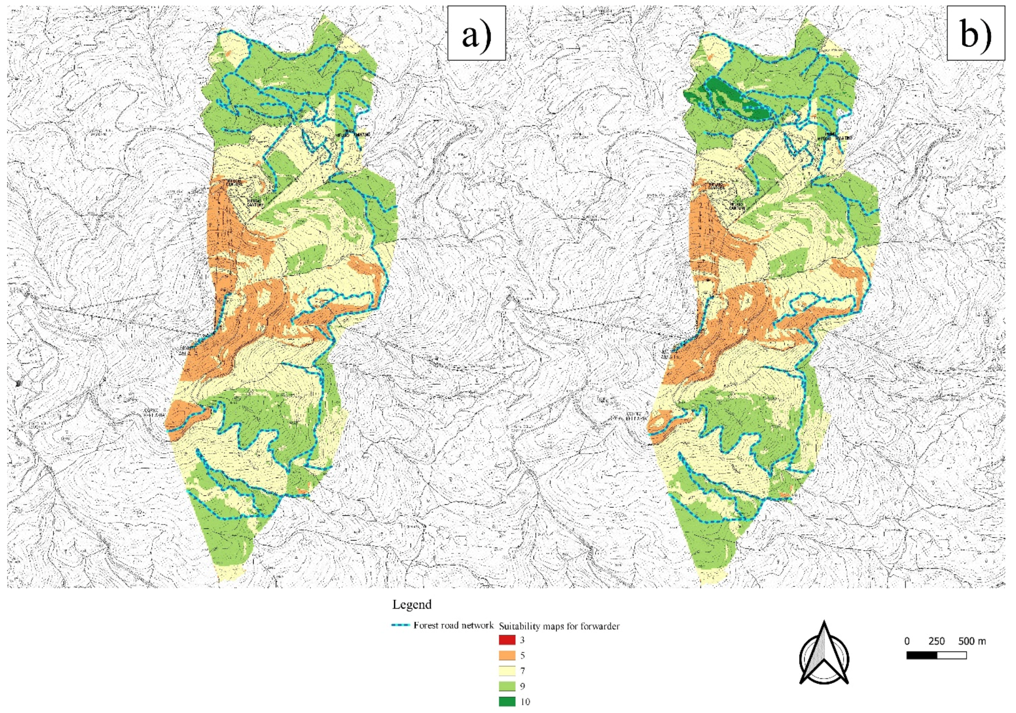
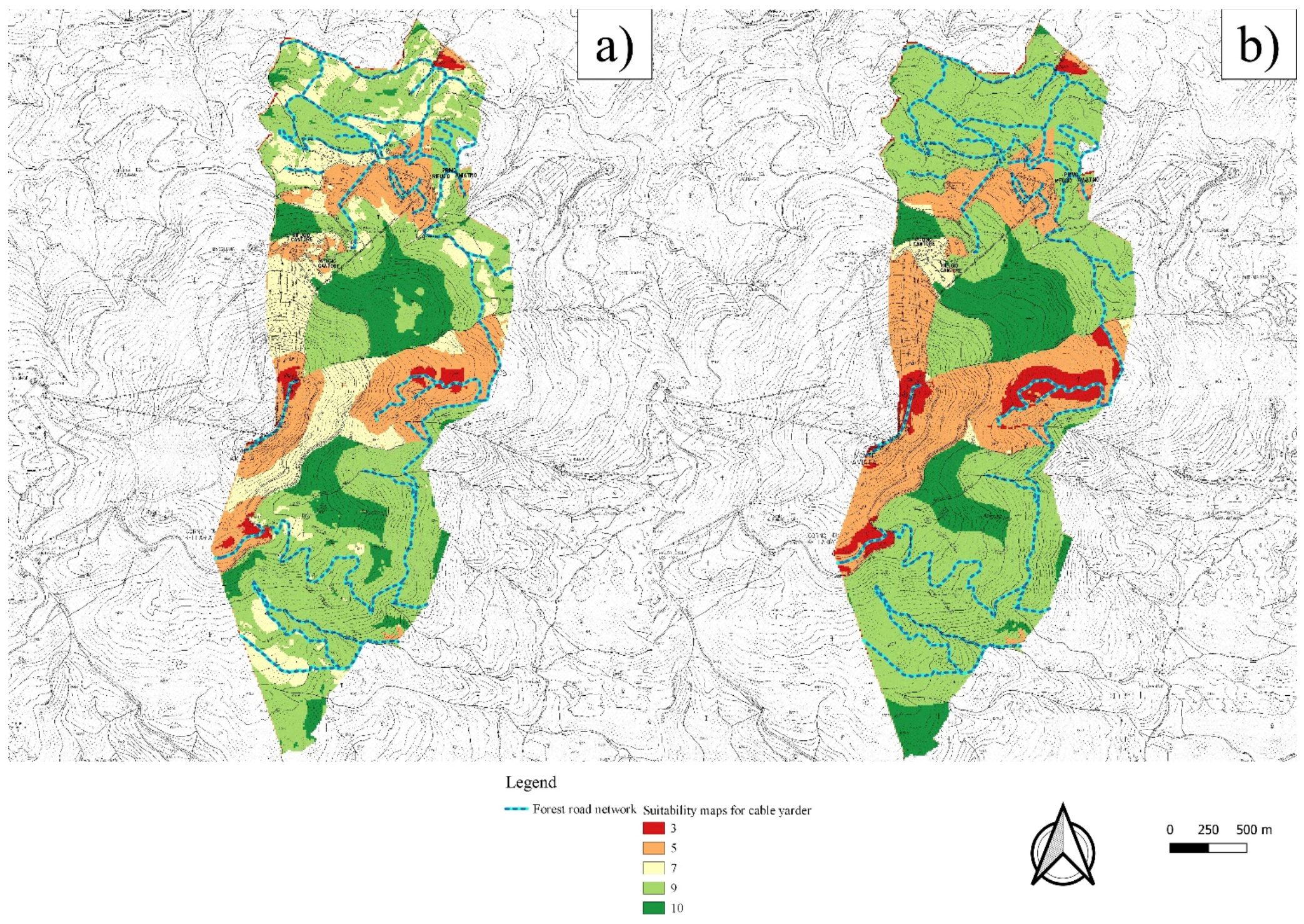
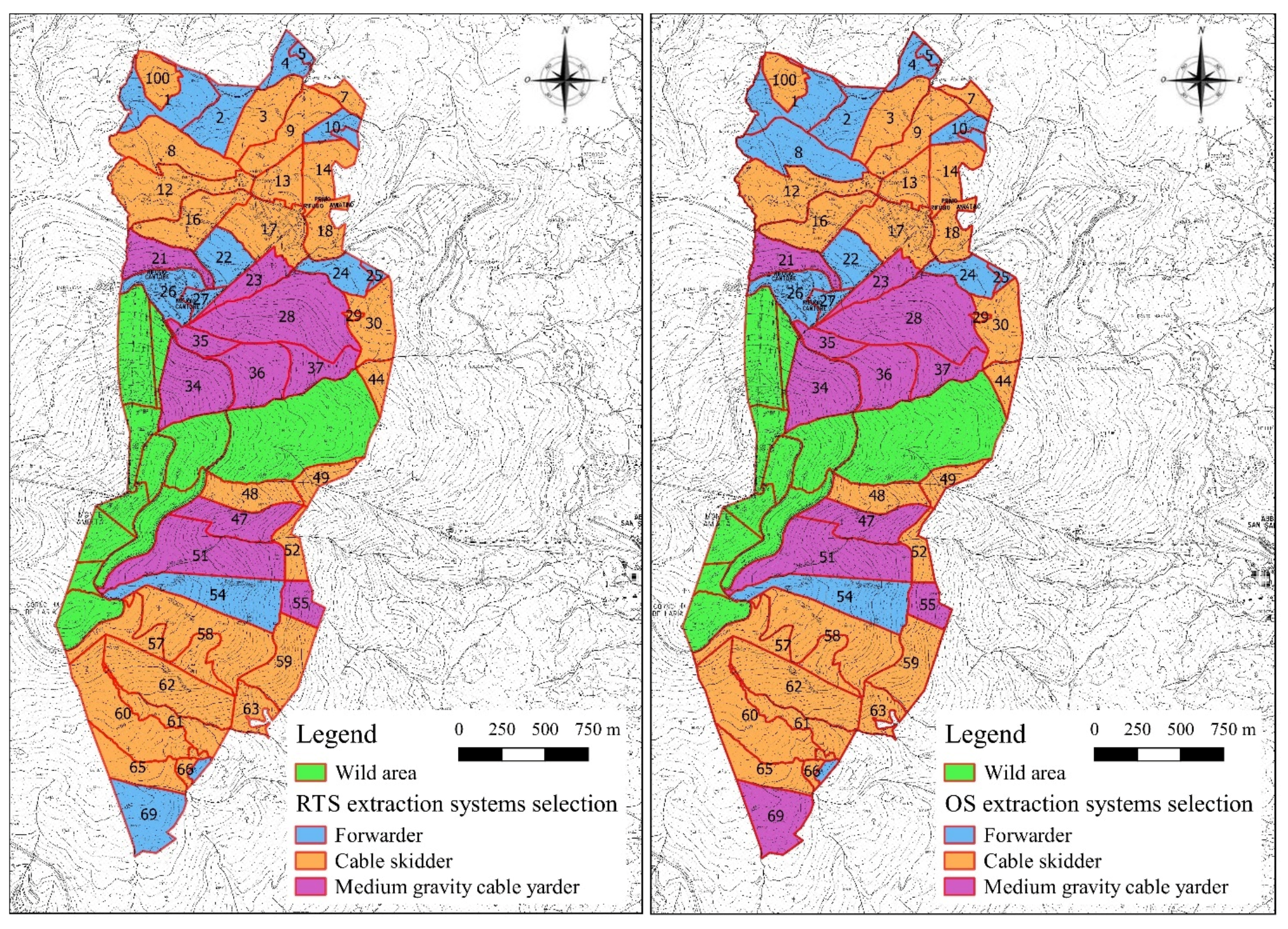
2.5. Development of the Suitability Maps for the Various Extraction Systems and Definition of the Best Alternative for Each Sub-Compartment

Subsequently, an AHP pairwise comparison matrix was developed for both RTS and OS in order to determine the weights of each criterion for each of the three extraction systems; to perform the calculation, the dedicated tool of Quantum GIS was applied [63]. CR value was calculated as well to check for the consistency of the weights. The various pairwise comparison matrices for the various extraction systems in both RTS and OS are given in Table 4.
The overall suitability of each extraction system for each pixel of the study area was calculated with the map algebra approach via the raster calculator of Quantum GIS. In detail, a weighted average function was applied for each extraction system multiplying the score of the criteria for its related weight, derived from the AHP pairwise comparison matrix. The suitability map of each extraction system was further reclassified into 10 classes [64].
The overlapping between the vector file of the various sub-compartments of the study area and the suitability maps for each extraction system, performed with the raster statistic tool, allowed for the identification of the most suitable extraction system for each sub-compartment. The raster suitability maps were sampled with the vector file of the sub-compartment, extracting the median value of each suitability map within each sub-compartment. The best alternative for extraction was identified as the system in each forest parcel which showed the highest median value of suitability in the specific sub-compartment. In the case of equal values between two extraction systems, the selection was carried out with forwarder as the best alternative, followed by cable skidder, and leaving cable yarder as a final option. This assertion was developed considering the fact that, when it is possible to choose, forest engineers and operators are generally prone to favour ground-based extraction rather than aerial [52,65,66]. The procedure was applied two times, one with input data from RTS and one from OS to allow for comparisons of the results. In particular, RTS was considered as the target simulation while OS was taken as a comparison to check the consistency of RTS results.

2.6. Statistical Analysis

Statistical analysis was carried out via Statistica 7.0 software. Spearman’s rank correlation coefficient was calculated to identify the criteria which had the highest influence on the selection of a given extraction system regarding the RTS simulation. Paired samples t test was instead applied to evaluate the presence of statistically significant differences between the extraction systems selected in the various sub-compartments with RTS and OS.

3. Results and Discussions

Recently, several new policies and strategies have been observed in forestry, mainly related to the growing interest in sustainability due to the importance of forests as an environmental and social value [67]. Cutting-edge technology and electronic devices are potentially powerful instruments to use towards this goal. As confirmed in other studies [9,20,30,31,39,55], precision forestry, GNSS, and GIS are useful technologies for forest operations and could help to improve and optimize SFM. However, it is not always easy to apply objectively shared criteria and choices in the planning and design phase and then in the executive one.
Suitability maps, which are the base for the proposed GIS-AHP methodology, represent an interesting tool in this optic [16], giving the possibility to the forest manager to identify the zones where a given harvesting system can be applied.
The suitability maps for forwarder calculated with RTS and OS input data are reported in Figure 2a,b, respectively. As it is possible to notice, only little differences are present between the two simulations. The main difference regards the northeast part of the study area, where there is a zone in which the forwarder reached the top level of suitability, i.e., score 10, for OR, while for RTS, the score was 9. In both cases, the highest level of suitability for the forwarder was reported in the northern and southern parts of the study area, where there is the presence of soils with high bearing capacity (Figure S6).
The suitability maps developed for the cable skidder are reported in Figure 3. There are not evident differences between the RTS and OS results. In both cases, cable skidder is recommended mostly in the zones with high road density and low extraction distance. Comparing the suitability maps for the cable skidder to the ones related to the forwarder shows further evidence on how the cable skidder results were able to reach the highest score of suitability (10) in a substantially major portion of the study area.
Finally, the suitability maps for the cable yarder are reported in Figure 4. For both RTS and OS, this system reached a high level of suitability in the zones with higher extracted timber amount and/or low road density. These results confirm what is reported in the current literature, which indicates this system as the most suitable in the case of low presence of roads, and is strongly related, in the optic of cost effectiveness, to the magnitude of the harvesting intervention [34,68]. A major difference which is possible to notice while analysing the suitability maps for the cable yarder in comparison to the ones for the forwarder is the high variability of suitability scores within the study area. The forwarder reached a minimum score of 5 but a maximum of only 9, while instead for cable yarder, there are zones that are highly unsuitable (score 3) but also areas that are highly suitable (score 10). In a few words, it seems that in the study area, the forwarder can be applied in the great major part of the study area, but without being nowhere in its perfect conditions of applicability. Conversely, the cable yarder cannot be applied to a large amount of the study area, but there are zones in which it is in perfect condition for its successful application.
Starting from the overlaying of the various suitability maps, the extraction method selection performed with RTS input data showed that the most suitable extraction method in the major part of the study area was the cable skidder. According to this simulation, 54.34% of the Macchia Faggeta surface indicated the cable skidder as the best option for timber extraction. This percentage of surface corresponds to 27 sub-compartments for an overall surface of 244.49 ha. The cable yarder was selected as the best alternative in 26.67% of the surface, corresponding to 10 sub-compartments for a whole surface of 119.98 ha. Finally, the forwarder was selected in 14 sub-compartments, equivalent to 85.43 ha (18.99% of the surface).
The extraction system selection performed with OS input data revealed limited differences. In detail, the cable skidder was selected as the most suitable option in the major part of the surface in this case. This ground-based extraction system was indicated as the best alternative in 26 sub-compartments, which corresponded to 230.27 ha and 51.18% of the planned surface. Both the forwarder and cable yarder showed a slightly higher suitability when compared to the RTS results. The cable yarder was selected in 11 sub-compartments (131.73 ha and 29.28% of the surface), with the forwarder in 14 sub-compartments, corresponding to 87.91 ha and 19.54% of the surface.
The graphic representation of the extraction system selection carried out with RTS (left side) and OS (right side) is given in Figure 5.
It can also be seen that only two of the fifty-one investigated sub-compartments changed the selected extraction method from RTS to OS. In particular, in sub-compartment 8 (northwest on the study area), RTS indicated the cable skidder as an option, while OS selected the forwarder. In sub-compartment 69 (south of the study area), instead RTS selected the forwarder while OS the cable yarder.
Such differences can be attributed to the different weights that RTS and OS gave to the different criteria for the various extraction methods. In sub-compartment 8, the selection of the cable skidder by RTS can be related to the higher weight that the researcher and technicians assigned to the criterion road density for this extraction method (RD, 0.259 in RTS and 0.155 in OS, Table 3). The RD value in sub-compartment 8 is not particularly high, i.e., 153 m ha−1, corresponding to a score of 5 for the cable skidder while only 4 for the forwarder (Table 2). The fact that this criterion had a relatively high weight, as in RTS, led to the selection of the cable skidder as the best alternative, while the lower weight in OS probably allowed for the assignment of the forwarder as the best option.
The change in sub-compartment 69 (from the forwarder in RTS to the medium-gravity cable yarder in OS) could instead be related to the higher weight that forest operators assigned to the criterion ED (extraction distance). Table 4 shows that ED weight in RTS was 0.161 and 0.228 in OS. As reported in Table 2, the average score for this criterion in sub-compartment 69 was 4 for the forwarder and 5 for the cable yarder. Therefore, such differences could be at the base of the shift from the forwarder to the cable yarder in this sub-compartment.
Thus, considering what is reported above, it can be stated that the applied GIS-AHP methodology showed good performance and high consistency in the selection of the best alternative among different extraction methods.
This statement was further confirmed by the results of the paired samples t test, carried out comparing the values of the overall suitability of the different extraction methods in the various sub-compartments according to both RTS and OS input data.
No statistically significant differences (p < 0.05) were found for both the forwarder suitability values and the cable skidder ones. Only the medium-gravity cable yarder showed statistically significant differences. However, as previously stated, the low level of difference did not lead to many variations in the definition of the best option for timber extraction between RTS and OS. The results of the paired samples t test are given in Table 5.
Spearman correlation analysis was performed to evaluate the various parameters, and which ones had the highest influence in the selection of a given extraction method with the applied methodology. The results of this elaboration are given in Table 6.
There was a significant positive correlation among the selection of the extraction method with the forwarder and the parameters of the extracted timber amount (ETA) and soil bearing capacity (SBC). While a significant negative correlation was observed for slope (S) and extraction distance (S), for these last parameters, the correlation is not as strong as the other ones. Focusing on the cable skidder, there is a presence of a strong positive correlation with road density (RD) as well as a negative correlation with the extraction distance (ED). For the selection of the cable yarder, the most important parameters were slope (S) and extraction distance (ED).
The obtained results confirmed that the forwarder is considered suitable in the condition of high soil bearing capacity, considering the large amount of forest area that this machinery has to travel as a consequence of the low working distance. No systems showed significant correlation for roughness, which would be expected to be an important parameter when dealing with ground-based extraction.
A possible further development of this study, under the point of view of a practical implementation at the management level, could be the introduction of economic parameters and analysis, which could be integrated into the GIS environment [55]. Starting from the selection of the most suitable harvesting system, and considering the costs of the harvesting machineries and the ones related to the maintenance of the forest road network, it will be possible to evaluate the cost effectiveness of the various logging interventions and estimating in advance the stumpage value of the various interventions [69,70,71].

4. Conclusions

The application of precision forestry and GIS has been identified as a powerful tool for the implementation of Sustainable Forest Management. The outcome of this work confirms the importance of statistical–mathematical approaches in order to support the decision-making process in applied management.
At the planning level, there are some problems with these approaches which place more emphasis on the practical implementation in real forest yards. Adequate operators, engineers, and manager training could help to improve the sustainability of forest management.
All in all, the authors applied a GIS-AHP approach to select the best alternative from among three different methods for timber extraction in a Mediterranean mountainous context. The analysis was carried out with an open-source GIS software and relying on input data for the AHP from a pool of experts from different parts of the world, which was substantially higher than the one presented in previous similar studies. This substantial amount of input data, and the fact that such data came from all over the world, overcame the rather local approach which is generally intrinsic in this kind of study. The results obtained consisted mostly of the AHP weights for the various criteria to select the extraction method, which can be taken and applied worldwide in every FMP where there is a need to choose the best alternative for timber extraction. Most rely on machinery specifically developed for harvesting purposes, which have shown the highest level of comprehensive sustainability. Moreover, considering the AHP results from the present study, each forest manager who has to draft an FMP can apply such procedures with a simple map algebra procedure, performable with open-source software and medium-sized hardware. In contexts which are different from the one reported in this case study and in the case that the managers want to evaluate the suitability of different extraction systems, such as for instance, animals or a chute system, the procedure has to be repeated while applying different weights and criteria classes.
Furthermore, an important aspect of this study consists of trying to carry out a consistency check for the obtained results. This is a difficult issue when dealing with harvesting methods selection, because it is rather complicated to assert that the selected option is actually the best one. The idea of comparing the results obtained from a survey based on a pool of researchers and forest engineers (RTS) is to be taken as a target simulation to be evaluated. The target simulation based on data derived from a pool of expert forest operators (OS) is then used to check the results of the other type of simulation. This tool for comparison and evaluation is an innovative aspect in this field of study.
The results obtained from the consistency check were encouraging, considering that, for 51 sub-compartments, only two changed the selected extraction system from between RTS to OS. We suggest that future research is performed to gain more knowledge in the evaluation of cable yarder extraction. It is worth noting that the cable yarder extraction showed statistically significant differences in the suitability values between RTS and OS. Therefore, the development of a software or web tool implementing the applied algorithms would give forest managers from all the world the opportunity to create their own simulation, helping to gain significant advantages in the process of FMP. A further step could be the implementation of algorithms to evaluate the different extraction systems under the economic point of view considering the features of the various sub-compartments, providing the managers with a tool able to predict the stumpage value of the various stands.

Supplementary Materials

The following supporting information can be downloaded at: https://www.mdpi.com/article/10.3390/f13030484/s1, Figure S1: Map for the criterion extraction distance, measure unit is m; Figure S2: Map for the criterion slope, measure unit is %; Figure S3: Map for the criterion extracted timber amount, measure unit is m3 ha-1; Figure S4: Map for the criterion road density, measure unit is m ha-1; Figure S5: Map for the criterion roughness, measure unit is %; Figure S6: Map for the criterion soil bearing capacity, measure unit is kPa.

Author Contributions

F.L.: Conceptualisation, Methodology, Formal Analysis, Investigation, Writing—Original Draft, Writing—Review and Editing. W.S.: Methodology, Investigation, Writing—Original Draft, Writing—Review and Editing. R.V.: Methodology, Investigation, Writing—Original Draft, Writing—Review and Editing. D.T.: Conceptualisation, Methodology, Investigation, Writing—Original Draft, Writing—Review and Editing. R.P.: Conceptualisation, Methodology, Writing—Review and Editing, Supervision. All authors have read and agreed to the published version of the manuscript.

Funding

This research received no external funding.

Data Availability Statement

The data presented in this study are available on request from the corresponding author.

Acknowledgments

The authors gratefully acknowledge Macchia Faggeta Company, Abbadia San Salvatore—Italy. This research was carried out in part within the framework of the MIUR (Italian Ministry for Education, University and Research) initiative “Departments of Excellence” (Law 232/2016), WP3, which financed the Department of Agriculture and Forest Science at the University of Tuscia. This research was carried out in part within the project PLANNING CHANGE (CAMBIO PIANO), PSR 2014-2020 Tuscany Region, met. Leader. Meas. 16.2—Gal F.A.R. Maremma.

Conflicts of Interest

The authors declare no conflict of interest.

References

  1. Knight, R.L.; White, C. Conservation for a New Generation: Redefining Natural Resources Management; Sland Press: Washington, DC, USA, 2008; ISBN 1597269212. [Google Scholar]
  2. Shadbahr, J.; Bensebaa, F.; Ebadian, M. Impact of forest harvest intensity and transportation distance on biomass delivered costs within sustainable forest management-A case study in southeastern Canada. J. Environ. Manag. 2021, 284, 112073. [Google Scholar] [CrossRef] [PubMed]
  3. Kangas, J.; Kangas, A. Multiple criteria decision support in forest management—the approach, methods applied, and experiences gained. For. Ecol. Manag. 2005, 207, 133–143. [Google Scholar] [CrossRef]
  4. Murphy, P.N.C.; Ogilvie, J.; Castonguay, M.; Zhang, C.F.; Meng, F.R.; Arp, P.A. Improving forest operations planning through high-resolution flow-channel and wet-areas mapping. For. Chron. 2008, 84, 568–574. [Google Scholar] [CrossRef] [Green Version]
  5. Ferreira da Silva, E.; Fernandes da Silva, G.; Orfanó Figueiredo, E.; Ribeiro de Mendonça, A.; Junio de Oliveira Santana, C.; César Fiedler, N.; Pereira Martins Silva, J.; Otone Aguiar, M.; Silva Santos, J. Optimized forest planning: Allocation of log storage yards in the Amazonian sustainable forest management area. For. Ecol. Manag. 2020, 472, 118231. [Google Scholar] [CrossRef]
  6. Kazama, V.S.; Corte, A.P.D.; Robert, R.C.G.; Sanquetta, C.R.; Arce, J.E.; Oliveira-Nascimento, K.A.; DeArmond, D. Global review on forest road optimization planning: Support for sustainable forest management in Amazonia. For. Ecol. Manag. 2021, 492, 119159. [Google Scholar] [CrossRef]
  7. MacDicken, K.G.; Sola, P.; Hall, J.E.; Sabogal, C.; Tadoum, M.; de Wasseige, C. Global progress toward sustainable forest management. For. Ecol. Manag. 2015, 352, 47–56. [Google Scholar] [CrossRef] [Green Version]
  8. Cristan, R.; Aust, W.M.; Bolding, M.C.; Barrett, S.M.; Munsell, J.F.; Schilling, E. Effectiveness of forestry best management practices in the United States: Literature review. For. Ecol. Manag. 2016, 360, 133–151. [Google Scholar] [CrossRef] [Green Version]
  9. Picchio, R.; Latterini, F.; Mederski, P.S.; Tocci, D.; Venanzi, R.; Stefanoni, W.; Pari, L. Applications of GIS-Based Software to Improve the Sustainability of a Forwarding Operation in Central Italy. Sustainability 2020, 12, 5716. [Google Scholar] [CrossRef]
  10. Sohrabi, H.; Jourgholami, M.; Jafari, M.; Shabanian, N.; Venanzi, R.; Tavankar, F.; Picchio, R. Soil recovery assessment after timber harvesting based on the sustainable forest operation (SFO) perspective in iranian temperate forests. Sustainability 2020, 12, 2874. [Google Scholar] [CrossRef] [Green Version]
  11. Ellis, E.A.; Montero, S.A.; Hernández Gómez, I.U.; Romero Montero, J.A.; Ellis, P.W.; Rodríguez-Ward, D.; Blanco Reyes, P.; Putz, F.E. Reduced-impact logging practices reduce forest disturbance and carbon emissions in community managed forests on the Yucatán Peninsula, Mexico. For. Ecol. Manag. 2019, 437, 396–410. [Google Scholar] [CrossRef]
  12. Marchi, E.; Chung, W.; Visser, R.; Abbas, D.; Nordfjell, T.; Mederski, P.S.; McEwan, A.; Brink, M.; Laschi, A. Sustainable Forest Operations (SFO): A new paradigm in a changing world and climate. Sci. Total Environ. 2018, 634, 1385–1397. [Google Scholar] [CrossRef] [Green Version]
  13. Maleki, K.; Lafleur, B.; Leduc, A.; Bergeron, Y. Modelling the influence of different harvesting methods on forest dynamics in the boreal mixedwoods of western Quebec, Canada. For. Ecol. Manag. 2021, 479, 118545. [Google Scholar] [CrossRef]
  14. Blagojević, B.; Jonsson, R.; Björheden, R.; Nordström, E.; Lindroos, O. Multi-Criteria Decision Analysis (MCDA) in Forest Operations—An Introductional Review. Croat. J. For. Eng. 2019, 40, 191–2015. [Google Scholar]
  15. Bont, L.G.; Fraefel, M.; Frutig, F.; Holm, S.; Ginzler, C.; Fischer, C. Improving forest management by implementing best suitable timber harvesting methods. J. Environ. Manag. 2022, 302, 114099. [Google Scholar] [CrossRef]
  16. Marčeta, D.; Petković, V.; Ljubojević, D.; Potočnik, I. Harvesting system suitability as decision support in selection cutting forest management in northwest Bosnia and Herzegovina. Croat. J. For. Eng. 2020, 41, 251–265. [Google Scholar] [CrossRef]
  17. Gülci, N.; Akay, A.E.; Erdaş, O. Optimal planning of timber extraction methods using analytic hierarchy process. Eur. J. For. Res. 2020, 139, 647–654. [Google Scholar] [CrossRef]
  18. Pingoud, K.; Ekholm, T.; Sievänen, R.; Huuskonen, S.; Hynynen, J. Trade-offs between forest carbon stocks and harvests in a steady state—A multi-criteria analysis. J. Environ. Manag. 2018, 210, 96–103. [Google Scholar] [CrossRef]
  19. Saaty, R.W. The analytic hierarchy process-what it is and how it is used. Math. Model. 1987, 9, 161–176. [Google Scholar] [CrossRef] [Green Version]
  20. Picchio, R.; Proto, A.R.; Civitarese, V.; Di Marzio, N.; Latterini, F. Recent Contributions of Some Fields of the Electronics in Development of Forest Operations Technologies. Electronics 2019, 8, 1465. [Google Scholar] [CrossRef] [Green Version]
  21. Sari, F. Forest fire susceptibility mapping via multi-criteria decision analysis techniques for Mugla, Turkey: A comparative analysis of VIKOR and TOPSIS. For. Ecol. Manag. 2021, 480, 118644. [Google Scholar] [CrossRef]
  22. Görgens, E.B.; Mund, J.-P.; Cremer, T.; de Conto, T.; Krause, S.; Valbuena, R.; Rodriguez, L.C.E. Automated operational logging plan considering multi-criteria optimization. Comput. Electron. Agric. 2020, 170, 105253. [Google Scholar] [CrossRef]
  23. Thiffault, N.; Raymond, P.; Lussier, J.-M.; Aubin, I.; Royer-Tardif, S.; D’Amato, A.W.; Doyon, F.; Lafleur, B.; Perron, M.; Bousquet, J. Adaptive Silviculture for Climate Change: From Concepts to Reality Report on a symposium held at Carrefour Forêts 2019. For. Chron. 2021, 97, 13–27. [Google Scholar] [CrossRef]
  24. Pykäläinen, J. Interactive Use of Multi-Criteria Decision Analysis in Forest Planning. Ph.D. Thesis, University of Joensuu (Finland), Faculty of Forestry, Joensuu, Finland, 2000. [Google Scholar]
  25. Picchio, R.; Spina, R.; Maesano, M.; Carbone, F.; Lo Monaco, A.; Marchi, E. Stumpage value in the short wood system for the conversion into high forest of a oak coppice. For. Stud. China 2011, 13, 252–262. [Google Scholar] [CrossRef]
  26. Chen, Y.; Yu, J.; Khan, S. Spatial sensitivity analysis of multi-criteria weights in GIS-based land suitability evaluation. Environ. Model. Softw. 2010, 25, 1582–1591. [Google Scholar] [CrossRef]
  27. Wang, Q.; Zhang, Y.; Lv, Q.; Xiang, C.; Xia, X.; Liu, J. Susceptibility assessment of soil erosion in overlaying diluvial fan of shallow underground pipelines. Bull. Eng. Geol. Environ. 2021, 80, 2573–2585. [Google Scholar] [CrossRef]
  28. Cortez-Núñez, J.A.; Gutiérrez-Castillo, M.E.; Mena-Cervantes, V.Y.; Terán-Cuevas, Á.R.; Tovar-Gálvez, L.R.; Velasco, J. A GIS Approach Land Suitability and Availability Analysis of Jatropha Curcas L. Growth in Mexico as a Potential Source for Biodiesel Production. Energies 2020, 13, 5888. [Google Scholar] [CrossRef]
  29. Khan, S.; Mohiuddin, K. Evaluating the parameters of ArcGIS and QGIS for GIS Applications. Int. J. Adv. Res. Sci. Eng. 2018, 7, 582–594. [Google Scholar]
  30. Picchio, R.; Latterini, F.; Mederski, P.S.; Venanzi, R.; Karaszewski, Z.; Bembenek, M.; Croce, M. Comparing Accuracy of Three Methods Based on the GIS Environment for Determining Winching Areas. Electronics 2019, 8, 53. [Google Scholar] [CrossRef] [Green Version]
  31. Picchio, R.; Pignatti, G.; Marchi, E.; Latterini, F.; Benanchi, M.; Foderi, C.; Venanzi, R.; Verani, S. The Application of Two Approaches Using GIS Technology Implementation in Forest Road Network Planning in an Italian Mountain Setting. Forests 2018, 9, 277. [Google Scholar] [CrossRef] [Green Version]
  32. Labelle, E.; Breinig, L.; Sycheva, E. Exploring the Use of Harvesters in Large-Diameter Hardwood-Dominated Stands. Forests 2018, 9, 424. [Google Scholar] [CrossRef] [Green Version]
  33. Borz, S.A.; Marcu, M.V.; Cataldo, M.F. Evaluation of an HSM 208F 14tone HVT-R2 Forwarder Prototype under Conditions of Steep-Terrain Low-Access Forests. Croat. J. For. Eng. 2021, 42, 185–200. [Google Scholar] [CrossRef]
  34. Stoilov, S.; Proto, A.R.; Angelov, G.; Papandrea, S.F.; Borz, S.A. Evaluation of Salvage Logging Productivity and Costs in the Sensitive Forests of Bulgaria. Forests 2021, 12, 309. [Google Scholar] [CrossRef]
  35. Ghaffariyan, M.R. General productivity predicting model for skidder working in eucalypt plantations. Eur. J. For. Eng. 2021, 6, 1–6. [Google Scholar] [CrossRef]
  36. Søvde, N.E.; Astrup, R.; Talbot, B. An inverse shortest path approach to find forwarder productivity functions. Comput. Electron. Agric. 2019, 161, 53–61. [Google Scholar] [CrossRef]
  37. Tavankar, F.; Picchio, R.; Nikooy, M.; Jourgholami, M.; Naghdi, R.; Latterini, F.; Venanzi, R. Soil natural recovery process and Fagus orientalis lipsky seedling growth after timber extraction by wheeled skidder. Land 2021, 10, 113. [Google Scholar] [CrossRef]
  38. Naghdi, R.; Solgi, A. Effects of skidder passes and slope on soil disturbance in two soil water contents. Croat. J. For. Eng. 2014, 35, 73–80. [Google Scholar]
  39. Enache, A.; Pentek, T.; Ciobanu, V.D.; Stampfer, K. GIS based methods for computing the mean extraction distance and its correction factors in Romanian mountain forests. Sumar. List 2015, 139, 35–46. [Google Scholar]
  40. Strandgard, M.; Wiedemann, J.; Mitchell, R. Comparison of Productivity, Cost and Chip Quality of Four Balanced Harvest Systems Operating in a Eucalyptus globulus Plantation in Western Australia. Croat. J. For. Eng. 2019, 40, 39–48. [Google Scholar]
  41. Erber, G.; Haberl, A.; Pentek, T.; Stampfer, K. Impact of operational parameters on the productivity of whole tree cable yarding—A statistical analysis based on operation data. Austrian J. For. Sci. 2017, 134, 1–18. [Google Scholar]
  42. Gagliardi, K.; Ackerman, S.; Ackerman, P. Multi-product forwarder-based timber extraction: Time consumption and productivity analysis of two forwarder models over multiple products and extraction distances. Croat. J. For. Eng. 2020, 41, 231–242. [Google Scholar] [CrossRef] [Green Version]
  43. Sealey, L.L.; Van Rees, K.C.J. Influence of skidder traffic on soil bulk density, aspen regeneration, and vegetation indices following winter harvesting in the Duck Mountain Provincial Park, SK. For. Ecol. Manag. 2019, 437, 59–69. [Google Scholar] [CrossRef]
  44. Mariotti, B.; Hoshika, Y.; Cambi, M.; Marra, E.; Feng, Z.; Paoletti, E.; Marchi, E. Vehicle-induced compaction of forest soil affects plant morphological and physiological attributes: A meta-analysis. For. Ecol. Manag. 2020, 462, 118004. [Google Scholar] [CrossRef]
  45. Sampietro, J.A.; de Vargas, D.A.; Souza, F.L.; Nicoletti, M.F.; Bonazza, M.; Topanotti, L.R. Comparison of Forwarder Productivity and Optimal Road Density in Thinning and Clearcutting of Pine Plantation in Southern Brazil. Croat. J. For. Eng. 2022, 43, 65–77. [Google Scholar] [CrossRef]
  46. Heinimann, H.R. Forest road network and transportation engineering—State and perspectives. Croat. J. For. Eng. 2017, 38, 155–173. [Google Scholar]
  47. Ghaffarian, M.R.; Stampfer, K.; Sessions, J. Comparison of three methods to determine optimal road spacing for forwarder-type logging operations. J. For. Sci. 2009, 55, 423–431. [Google Scholar] [CrossRef] [Green Version]
  48. Tavankar, F.; Nikooy, M.; Latterini, F.; Venanzi, R.; Bianchini, L.; Picchio, R. The Effects of Soil Moisture on Harvesting Operations in Populus spp. Plantations: Specific Focus on Costs, Energy Balance and GHG Emissions. Sustainability 2021, 13, 4863. [Google Scholar] [CrossRef]
  49. Tavankar, F.; Picchio, R.; Nikooy, M.; Jourgholami, M.; Latterini, F.; Venanzi, R. Effect of soil moisture on soil compaction during skidding operations in poplar plantation. Int. J. For. Eng. 2021, 32, 128–139. [Google Scholar] [CrossRef]
  50. Schweier, J.; Ludowicy, C. Comparison of A Cable-Based and a Ground-Based System in Flat and Soil-Sensitive Area: A Case Study from Southern Baden in Germany. Forests 2020, 11, 611. [Google Scholar] [CrossRef]
  51. Schönauer, M.; Väätäinen, K.; Prinz, R.; Lindeman, H.; Pszenny, D.; Jansen, M.; Maack, J.; Talbot, B.; Astrup, R.; Jaeger, D. Spatio-temporal prediction of soil moisture and soil strength by depth-to-water maps. Int. J. Appl. Earth Obs. Geoinf. 2021, 105, 102614. [Google Scholar] [CrossRef]
  52. Enache, A.; Kühmaier, M.; Visser, R.; Stampfer, K. Forestry operations in the European mountains: A study of current practices and efficiency gaps. Scand. J. For. Res. 2016, 31, 412–427. [Google Scholar] [CrossRef]
  53. Labelle, E.R.; Hansson, L.; Högbom, L.; Jourgholami, M.; Laschi, A. Strategies to Mitigate the Effects of Soil Physical Disturbances Caused by Forest Machinery: A Comprehensive Review. Curr. For. Rep. 2022, in press. [Google Scholar] [CrossRef]
  54. Magagnotti, N.; Spinelli, R.; Kärhä, K.; Mederski, P.S. Multi-tree cut-to-length harvesting of short-rotation poplar plantations. Eur. J. For. Res. 2021, 140, 345–354. [Google Scholar] [CrossRef]
  55. Latterini, F.; Stefanoni, W.; Suardi, A.; Alfano, V.; Bergonzoli, S.; Palmieri, N.; Pari, L. A GIS Approach to Locate a Small Size Biomass Plant Powered by Olive Pruning and to Estimate Supply Chain Costs. Energies 2020, 13, 3385. [Google Scholar] [CrossRef]
  56. Tuscany Region Geodata of Tuscany Region. 2020. Available online: http://geoblog.regione.toscana.it/-/open-geodata (accessed on 30 November 2020).
  57. George, K.P. Falling Weight Deflectometer for Estimating Subgrade Resilient Moduli; University of Mississippi: Oxford, MS, USA, 2003. [Google Scholar]
  58. Kaakkurivaara, T.; Vuorimies, N.; Kolisoja, P.; Uusitalo, J. Applicability of portable tools in assessing the bearing capacity of forest roads. Silva Fenn. 2015, 49, 1239. [Google Scholar] [CrossRef] [Green Version]
  59. Louis, L.T.; Kizha, A.R.; Daigneault, A.; Han, H.-S.; Weiskittel, A. Factors Affecting Operational Cost and Productivity of Ground-Based Timber Harvesting Machines: A Meta-analysis. Curr. For. Rep. 2022, 8, 38–54. [Google Scholar] [CrossRef]
  60. Saaty, T.L. A scaling method for priorities in hierarchical structures. J. Math. Psychol. 1977, 15, 234–281. [Google Scholar] [CrossRef]
  61. Horodnic, S.A. A risk index for multicriterial selection of a logging system with low environmental impact. Environ. Impact Assess. Rev. 2015, 51, 32–37. [Google Scholar] [CrossRef]
  62. Jaafari, A.; Najafi, A.; Melón, M.G. Decision-making for the selection of a best wood extraction method: An analytic network process approach. For. Policy Econ. 2015, 50, 200–209. [Google Scholar] [CrossRef] [Green Version]
  63. Selim, M. EasyAHP plugin for Quantum GIS. 2015. Available online: https://plugins.qgis.org/plugins/EasyAHP/ (accessed on 5 November 2020).
  64. Delivand, M.K.; Cammerino, A.R.B.; Garofalo, P.; Monteleone, M. Optimal locations of bioenergy facilities, biomass spatial availability, logistics costs and GHG (greenhouse gas) emissions: A case study on electricity productions in South Italy. J. Clean. Prod. 2015, 99, 129–139. [Google Scholar] [CrossRef]
  65. Erber, G.; Spinelli, R. Timber extraction by cable yarding on flat and wet terrain: A survey of cable yarder manufacturer’s experience. Silva Fenn. 2020, 54, 1–19. [Google Scholar] [CrossRef] [Green Version]
  66. Schweier, J.; Blagojević, B.; Venanzi, R.; Latterini, F.; Picchio, R. Sustainability Assessment of Alternative Strip Clear Cutting Operations for Wood Chip Production in Renaturalization Management of Pine Stands. Energies 2019, 12, 3306. [Google Scholar] [CrossRef] [Green Version]
  67. Schweier, J.; Magagnotti, N.; Labelle, E.R.; Athanassiadis, D. Sustainability Impact Assessment of Forest Operations: A Review. Curr. For. Rep. 2019, 5, 101–113. [Google Scholar] [CrossRef] [Green Version]
  68. Lee, E.; Choi, Y.; Cho, M.; Cho, K.; Oh, J.; Han, S.; Im, S. A Literature Review on Cable Extraction Practices of South Korea: 1990–2020. Forests 2021, 12, 908. [Google Scholar] [CrossRef]
  69. Phelps, K.; Hiesl, P.; Hagan, D.; Hotaling Hagan, A. The Harvest Operability Index (HOI): A Decision Support Tool for Mechanized Timber Harvesting in Mountainous Terrain. Forests 2021, 12, 1307. [Google Scholar] [CrossRef]
  70. Ghajar, I. An Economical Transportation Plan for Forest Products Using a Computer-Aided Model. J. For. Econ. 2021, 36, 289–314. [Google Scholar] [CrossRef]
  71. Olsson, B.A.; Hannrup, B.; Jönsson, M.; Larsolle, A.; Nordström, M.; Mörtberg, U.; Rudolphi, J.; Strömgren, M. A decision support model for individual tree stump harvesting options based on criteria for economic return and environmental protection. Scand. J. For. Res. 2017, 32, 246–259. [Google Scholar] [CrossRef]
Figure 1. On the left, the subdivision into forest typologies of the study area. On the right, Macchia Faggeta boundaries and road network on a technical map of the Tuscany Region.
Forests 13 00484 g001
Figure 2. (a) Suitability map for forwarder, derived from the analysis with RTS input data. (b) Suitability map for forwarder, derived from the analysis with OS input data.
Forests 13 00484 g002
Figure 3. (a) Suitability map for forwarder, derived from the analysis with RTS input data. (b) Suitability map for forwarder, derived from the analysis with OS input data.
Forests 13 00484 g003
Figure 4. (a) Suitability map for forwarder, derived from the analysis with RTS input data. (b) Suitability map for forwarder, derived from the analysis with OS input data.
Forests 13 00484 g004
Figure 5. RTS extraction method selection (on the left) and OTS (on the right). As shown, the two predictions differ only for two sub-compartments (no. 8 and no. 69). In sub-compartment 8 (northwest of the study area), RTS indicated the cable skidder as an option, while OS selected the forwarder. In sub-compartment 69 (south of the study area), RTS selected the forwarder while OS the cable yarder.
Forests 13 00484 g005
Table 1. Identified criteria for the selection of the most suitable harvesting system with reference to the various pillars of sustainability.
CriterionAcronymEconomyEnvironmentSociety
Slope (%)S
Extraction Distance (m)ED
Soil Bearing Capacity (kPa)SBC
Extracted Timber Amount (m3 ha−1)ETA
Road Density (m ha−1)RD
Roughness (%)RG
Table 2. Suitability criteria classes for the different investigated extraction systems.
Extraction SystemCriteria
SlopeExtraction DistanceSoil Bearing CapacityExtracted Timber AmountRoad DensityRoughness
Range (%)ScoreRange (m)ScoreRange (kPa)ScoreRange (m3 ha−1)ScoreRange (m ha−1)ScoreRange (%)Score
Forwarder0–2050-1005>805>2005>20750–155
20–404100–200560–804100–2004138–207415–304
40–601200–400440–60280–100369–138330–451
>600>4001<400<801<691>450
Cable Skidder0–2050-1005>805>2005>20750–155
20–405100–200160–805100–2005138–207515–305
40–604200–400040–60380–100469–138430–454
>602>4000<401<803<692>453
Medium gravity Cable Yarder0–2000–1001>805>2005>20750–155
20–404100–200360–805100–2005138–207515–305
40–605200–400540–60580–100469–138430–455
>605>4005<403<801<693>454
Table 3. Details of the survey.
CountryRTSOS
AskedRespondentsAskedRespondents
Albany7311
Argentina7311
Australia8422
Austria8420
Brazil12231
Canada12464
Cameroon7331
Chile6220
China7320
Congo8440
Croatia15873
Czech Republic7353
United Kingdom15642
France7353
Germany9553
Greece6220
India5120
Iran6211
Italy29171510
Japan7331
New Zealand9542
Poland12231
Romania14142
Russia8442
Slovenia8442
South Africa7342
Spain15353
Sweden9332
Switzerland7331
Turkey8231
Uganda6220
USA9555
Total30011911959
Table 4. AHP pairwise comparison matrices.
RTSForwarder
CriteriaSEDSBCETARDRGweightsCR
S110.51110.1430.0001
ED-10.51110.143
SBC--12220.286
ETA---1110.143
RD----110.143
RG-----10.143
Cable Skidder
CriteriaSEDSBCETARDRGweightsCR
S10.5120.510.1360.002
ED-123120.259
SBC--120.510.136
ETA---10.33330.50.075
RD----120.259
RG-----10.136
Medium Gravity Cable Yarder
CriteriaSEDSBCETARDRGweightsCR
S1130.3333130.1610.01
ED-130.3333130.161
SBC--10.20.333310.06
ETA---1350.399
RD----130.161
RG-----10.06
OSForwarder
CriteriaSEDSBCETARDRGweightsCR
S110.51220.1710.003
ED-10.51220.171
SBC--12330.31
ETA---1220.171
RD----110.089
RG-----10.089
Cable Skidder
CriteriaSEDSBCETARDRGweightsCR
S10.512110.1550.001
ED-123220.297
SBC--12110.155
ETA---10.50.50.082
RD----110.155
RG-----10.155
Medium Gravity Cable Yarder
CriteriaSEDSBCETARDRGweightsCR
S10.2510.140.50.50.0540.012
ED-140.3333330.228
SBC--10.140.50.50.054
ETA---1550.47
RD----110.097
RG-----10.097
Table 5. Paired samples t test results. * indicates statistically significant differences (p < 0.05).
Paired Samples t Test, Significance Level p < 0.05
AverageStandard Deviationtp
Forwarder RTS81.1
Forwarder OS81.2−1.00000.322126
Cable skidder RTS91.6
Cable skidder OS91.61.00000.322126
Medium gravity cable yarder RTS81.5
Medium gravity cable yarder OS91.5−2.362470.022086 *
Table 6. Results of Spearman correlation analysis. In bold, statistically significant results (p < 0.05).
Spearman Rp Level
Forwarder and RD0.2440.084
Forwarder and ETA0.5700.001
Forwarder and RG−0.0450.751
Forwarder and SBC0.5340.001
Forwarder and S−0.4850.001
Forwarder and ED−0.3000.033
Cable Skidder and RD0.8320.001
Cable Skidder and ETA0.3110.026
Cable Skidder and RG−0.0110.938
Cable Skidder and SBC0.1600.262
Cable Skidder and S−0.2400.090
Cable Skidder and ED−0.8560.001
Cable Yarder and RD−0.2200.121
Cable Yarder and ETA0.1690.236
Cable Yarder and RG−0.2610.064
Cable Yarder and SBC−0.0780.589
Cable Yarder and S0.4320.002
Cable Yarder and ED0.3700.008
Publisher’s Note: MDPI stays neutral with regard to jurisdictional claims in published maps and institutional affiliations.

