
Energy-Saving Geospatial Data Storage—LiDAR Point Cloud Compression


Abstract
1. Introduction
- -
- Scanners are working ever faster;
- -
- Point clouds are getting denser;
- -
- GDSs of orthophotos are getting smaller and smaller;
- -
- The resolution of remote sensing data is increasing;
- -
- Two-dimensional datasets are being developed into three-dimensional datasets;
- -
- Not only individual buildings, but entire towns and cities are being modelled;
- -
- Areas along roads are being covered with spherical images or LiDAR point clouds, e.g., Google Street View, HERE.
2. State of the Art
- -
- Coding-based compression methods applied to LiDAR data;
- -
- Format-based compression methods (LAS and PCD format only);
- -
- Two-dimensional-based intra-frame compression methods;
- -
- Two-dimensional-based inter-frame compression methods;
- -
- Three-dimensional tree-based compression methods;
- -
- Sparse-tensor-based and point-based methods.
3. Materials and Methods
3.1. Materials
3.2. Hardware, Software and Formats
- -
- General purpose compression algorithms (*.7z, *.bzip2, *.gzip, *.xz, *.zip, *.RAR, *.RAR4)—group 1 in Figure 1;
- -
- Compression algorithms specific to the LiDAR domain (*.pod, *.BIN, *.LAZ, *.E57, *.PCD, *.PN, *.PV, *.PNTS, *.PCD, *.PTS, *.RPC, *.3DL)—group 2 in Figure 1;
- -
- General/universal formats that do not have compression features (*.TXT, *.XYZ, *.ASC)—group 3 in Figure 1.
3.3. New LiDAR Data Format—3DL
3.4. Methods
- -
- Software name;
- -
- The output file format;
- -
- Compression method;
- -
- The compression ratio (where different ones were available);
- -
- Compression time (from file properties);
- -
- Size of the compressed file;
- -
- Compression ratio expressed in %.
4. Results

| Software | Format | Degree of Compression | Compression Method | File Size After Conversion [bytes] | CR [%] | File Size After Conversion [bytes] | CR [%] | File Size After Conversion [bytes] | CR [%] | File Size After Conversion [bytes] | CR [%] | Hardware Unit |
|---|---|---|---|---|---|---|---|---|---|---|---|---|
| ALS_LOK | ALS_PL2000 | TLS_LOK | TLS_PL2000 | |||||||||
| 540,096,009 | 540,096,009 | 623,973,543 | 623,973,545 | |||||||||
| 7-ZIP | 7z | Fastest | LZMA2 | 183,853,138 | 34.04% | 183,323,163 | 33.94% | 287,664,584 | 46.10% | 272,357,616 | 43.65% | A |
| LZMA | 183,312,951 | 33.94% | 182,774,246 | 33.84% | 285,769,978 | 45.80% | 271,351,338 | 43.49% | A | |||
| PPMd | 203,769,786 | 37.73% | 202,009,982 | 37.40% | 245,953,764 | 39.42% | 240,472,124 | 38.54% | A | |||
| BZip2 | 223,270,463 | 41.34% | 222,709,486 | 41.24% | 262,281,337 | 42.03% | 247,376,752 | 39.65% | A | |||
| Fast | LZMA2 | 186,484,089 | 34.53% | 186,034,629 | 34.44% | 280,523,707 | 44.96% | 270,878,191 | 43.41% | A | ||
| LZMA | 186,641,483 | 34.56% | 186,190,500 | 34.47% | 279,901,194 | 44.86% | 270,716,765 | 43.39% | A | |||
| PPMd | 195,636,293 | 36.22% | 194,180,492 | 35.95% | 232,906,444 | 37.33% | 224,313,535 | 35.95% | A | |||
| BZip2 | 210,506,586 | 38.98% | 209,879,182 | 38.86% | 240,660,381 | 38.57% | 230,580,968 | 36.95% | A | |||
| Normal | LZMA2 | 160,275,668 | 29.68% | 159,602,649 | 29.55% | 243,765,412 | 39.07% | 236,326,867 | 37.87% | A | ||
| LZMA | 160,153,984 | 29.65% | 159,490,150 | 29.53% | 242,327,364 | 38.84% | 235,862,307 | 37.80% | A | |||
| PPMd | 190,125,420 | 35.20% | 188,852,260 | 34.97% | 227,342,981 | 36.43% | 220,803,334 | 35.39% | A | |||
| BZip2 | 208,165,021 | 38.54% | 207,397,594 | 38.40% | 238,120,582 | 38.16% | 228,833,615 | 36.67% | A | |||
| Maximum | LZMA2 | 160,243,507 | 29.67% | 159,407,807 | 29.51% | 241,172,710 | 38.65% | 235,481,726 | 37.74% | A | ||
| LZMA | 160,070,590 | 29.64% | 159,550,368 | 29.54% | 240,303,864 | 38.51% | 235,083,569 | 37.68% | A | |||
| PPMd | 187,800,551 | 34.77% | 186,411,561 | 34.51% | 226,328,091 | 36.27% | 220,420,169 | 35.33% | A | |||
| BZip2 | 208,137,370 | 38.54% | 207,374,025 | 38.40% | 237,624,119 | 38.08% | 228,271,457 | 36.58% | A | |||
| Ultra | LZMA2 | 159,877,328 | 29.60% | 159,448,244 | 29.52% | 239,172,881 | 38.33% | 234,389,715 | 37.564% | A | ||
| LZMA | 160,175,956 | 29.66% | 159,390,352 | 29.51% | 239,039,985 | 38.31% | 234,336,981 | 37.556% | A | |||
| PPMd | 189,726,182 | 35.13% | 188,280,417 | 34.86% | 224,523,525 | 35.98% | 219,035,450 | 35.10% | A | |||
| BZip2 | 208,120,217 | 38.53% | 207,358,723 | 38.39% | 237,490,696 | 38.06% | 228,102,478 | 36.56% | A | |||
| bzip2 | BZip2 | Fastest | 223,270,293 | 41.34% | 222,709,324 | 41.24% | 262,281,191 | 42.03% | 247,376,590 | 39.65% | A | |
| Fast | 210,506,416 | 38.98% | 209,879,020 | 38.86% | 240,660,235 | 38.57% | 230,580,806 | 36.95% | A | |||
| Normal | 208,164,851 | 38.54% | 207,397,432 | 38.40% | 238,120,436 | 38.16% | 228,833,453 | 36.67% | A | |||
| Maximum | 208,137,200 | 38.54% | 207,373,863 | 38.40% | 237,623,973 | 38.08% | 228,271,295 | 36.58% | A | |||
| Ultra | 208,120,047 | 38.53% | 207,358,561 | 38.39% | 237,490,550 | 38.06% | 228,102,316 | 36.56% | A | |||
| gzip | deflate | Fastest | 242,246,293 | 44.85% | 242,853,849 | 44.96% | 351,633,352 | 56.35% | 324,863,932 | 52.06% | A | |
| Normal | 227,376,745 | 42.10% | 228,933,501 | 42.39% | 327,601,116 | 52.50% | 304,665,243 | 48.83% | A | |||
| Maximum | 226,737,427 | 41.98% | 228,334,717 | 42.28% | 326,904,830 | 52.39% | 304,002,413 | 48.72% | A | |||
| Ultra | 226,684,785 | 41.97% | 228,289,365 | 42.27% | 326,872,237 | 52.39% | 303,984,848 | 48.72% | A | |||
| xz | LAZM2 | Fastest | 183,867,724 | 34.04% | 183,337,752 | 33.95% | 287,681,464 | 46.10% | 272,374,492 | 43.65% | A | |
| Fast | 186,485,092 | 34.53% | 186,035,636 | 34.44% | 280,524,900 | 44.96% | 270,879,364 | 43.41% | A | |||
| Normal | 160,275,832 | 29.68% | 159,602,824 | 29.55% | 243,765,640 | 39.07% | 236,327,080 | 37.87% | A | |||
| Maximum | 160,243,540 | 29.67% | 159,407,844 | 29.51% | 241,172,768 | 38.65% | 235,481,768 | 37.74% | A | |||
| Ultra | 159,877,216 | 29.60% | 159,448,140 | 29.52% | 239,172,792 | 38.33% | 234,389,612 | 37.56% | A | |||
| zip | Fastest | deflate | 242,246,439 | 44.85% | 242,853,991 | 44.96% | 351,633,487 | 56.35% | 324,864,074 | 52.06% | A | |
| deflate64 | 239,780,146 | 44.40% | 240,034,578 | 44.44% | 343,736,483 | 55.09% | 322,368,465 | 51.66% | A | |||
| BZip2 | 223,270,489 | 41.34% | 222,709,512 | 41.24% | 262,281,365 | 42.03% | 247,376,778 | 39.65% | A | |||
| LZMA | 183,312,976 | 33.94% | 182,774,271 | 33.84% | 285,770,021 | 45.80% | 271,351,379 | 43.49% | A | |||
| PPMd | 203,367,199 | 37.65% | 201,395,803 | 37.29% | 245,806,178 | 39.39% | 240,053,742 | 38.47% | A | |||
| Fast | deflate | 242,246,439 | 44.85% | 242,853,991 | 44.96% | 351,633,487 | 56.35% | 324,864,074 | 52.06% | A | ||
| deflate64 | 239,780,146 | 44.40% | 240,034,578 | 44.44% | 343,736,483 | 55.09% | 322,368,465 | 51.66% | A | |||
| BZip2 | 210,506,612 | 38.98% | 209,879,208 | 38.86% | 240,660,409 | 38.57% | 230,580,994 | 36.95% | A | |||
| LZMA | 186,641,508 | 34.56% | 186,190,526 | 34.47% | 279,901,237 | 44.86% | 270,716,806 | 43.39% | A | |||
| PPMd | 196,704,570 | 36.42% | 195,052,758 | 36.11% | 234,031,036 | 37.51% | 224,686,317 | 36.01% | A | |||
| Normal | deflate | 227,376,891 | 42.10% | 228,933,643 | 42.39% | 327,601,251 | 52.50% | 304,665,385 | 48.83% | A | ||
| deflate64 | 221,386,075 | 40.99% | 222,247,617 | 41.15% | 316,486,963 | 50.72% | 298,794,503 | 47.89% | A | |||
| BZip2 | 208,165,047 | 38.54% | 207,397,620 | 38.40% | 238,120,610 | 38.16% | 228,833,641 | 36.67% | A | |||
| LZMA | 160,154,010 | 29.65% | 159,490,176 | 29.53% | 242,327,391 | 38.84% | 304,002,555 | 48.72% | A | |||
| PPMd | 190,995,848 | 35.36% | 189,864,697 | 35.15% | 227,860,185 | 36.52% | 220,537,514 | 35.34% | A | |||
| Maximum | deflate | 226,737,573 | 41.98% | 228,334,859 | 42.28% | 326,904,965 | 52.39% | 304,002,555 | 48.72% | A | ||
| deflate64 | 220,825,085 | 40.89% | 221,718,157 | 41.05% | 315,802,561 | 50.61% | 298,197,834 | 47.79% | A | |||
| BZip2 | 208,137,396 | 38.54% | 207,374,051 | 38.40% | 237,624,147 | 38.08% | 228,271,483 | 36.58% | A | |||
| LZMA | 160,070,616 | 29.64% | 159,550,394 | 29.54% | 240,303,891 | 38.51% | 235,083,594 | 37.68% | A | |||
| PPMd | 185,262,789 | 34.30% | 184,133,350 | 34.09% | 223,065,018 | 35.75% | 217,823,847 | 34.91% | A | |||
| Ultra | deflate | 226,684,931 | 41.97% | 228,289,507 | 42.27% | 326,872,372 | 52.39% | 303,984,990 | 48.72% | A | ||
| deflate64 | 220,788,078 | 40.88% | 221,692,570 | 41.05% | 315,801,833 | 50.61% | 298,177,167 | 47.79% | A | |||
| BZip2 | 208,120,243 | 38.53% | 207,358,749 | 38.39% | 237,490,724 | 38.06% | 228,102,504 | 36.56% | A | |||
| LZMA | 160,175,982 | 29.66% | 159,390,378 | 29.51% | 239,040,012 | 38.31% | 234,337,006 | 37.56% | A | |||
| PPMd | 190,493,738 | 35.27% | 189,254,440 | 35.04% | 218,230,545 | 34.97% | 212,636,602 | 34.08% | A | |||
| WINRAR | RAR | Fastest | 248,632,947 | 46.03% | 250,741,685 | 46.43% | 308,882,765 | 49.50% | 243,294,995 | 38.99% | A | |
| Fast | 212,058,229 | 39.26% | 212,071,730 | 39.27% | 290,661,576 | 46.58% | 242,338,900 | 38.84% | A | |||
| Normal | 204,240,439 | 37.82% | 204,164,127 | 37.80% | 288,836,516 | 46.29% | 241,845,813 | 38.76% | A | |||
| Good | 204,476,717 | 37.86% | 204,394,795 | 37.84% | 288,191,560 | 46.19% | 241,717,346 | 38.74% | A | |||
| Best | 204,535,539 | 37.87% | 204,453,740 | 37.86% | 287,906,673 | 46.14% | 241,656,155 | 38.73% | A | |||
| RAR4 | Fastest | 220,739,130 | 40.87% | 220,962,487 | 40.91% | 337,918,434 | 54.16% | 317,688,959 | 50.91% | A | ||
| Fast | 209,366,617 | 38.76% | 209,285,477 | 38.75% | 295,952,185 | 47.43% | 288,590,520 | 46.25% | A | |||
| Normal | 201,400,391 | 37.29% | 201,315,342 | 37.27% | 291,820,038 | 46.77% | 242,792,560 | 38.91% | A | |||
| Good | 201,603,523 | 37.33% | 201,516,359 | 37.31% | 291,059,647 | 46.65% | 242,610,617 | 38.88% | A | |||
| Best | 201,657,800 | 37.34% | 201,573,129 | 37.32% | 290,754,618 | 46.60% | 242,561,844 | 38.87% | A | |||
| ZIP | Fastest | 237,750,598 | 44.02% | 238,994,689 | 44.25% | 352,152,581 | 56.44% | 326,916,724 | 52.39% | A | ||
| Fast | 237,816,543 | 44.03% | 239,071,430 | 44.26% | 349,483,571 | 56.01% | 325,381,129 | 52.15% | A | |||
| Normal | 238,397,787 | 44.14% | 239,742,068 | 44.39% | 339,856,868 | 54.47% | 317,928,079 | 50.95% | A | |||
| Good | 239,149,513 | 44.28% | 240,517,081 | 44.53% | 338,998,624 | 54.33% | 317,429,342 | 50.87% | A | |||
| Best | 239,643,282 | 44.37% | 241,016,876 | 44.62% | 338,799,956 | 54.30% | 317,338,722 | 50.86% | ||||
| BEN PODCR | pod | Precision to 1 mm | 175,075,631 | 32.416% | 175,075,839 | 32.42% | 264,353,052 | 42.37% | 264,352,842 | 42.37% | A | |
| LASTOOLS | BIN | 32 | 381,244,136 | 70.59% | 381,244,136 | 70.59% | 479,979,476 | 76.92% | 479,979,476 | 76.92% | A | |
| 64 | 381,244,136 | 70.59% | 381,244,137 | 70.59% | 479,979,477 | 76.92% | 479,979,477 | 76.92% | A | |||
| LAZ | 32 | 80,739,471 | 14.95% | 80,739,471 | 14.95% | 290,783,953 | 46.60% | 231,193,873 | 37.05% | A | ||
| 64 | 80,739,471 | 14.95% | 80,739,472 | 14.95% | 290,783,954 | 46.60% | 231,193,874 | 37.05% | A | |||
| TXT | 32 | 1,006,883,110 | 186.43% | 1,126,156,881 | 208.51% | 1,029,311,815 | 164.96% | 1,275,337,421 | 204.39% | A | ||
| 64 | 1,006,883,110 | 186.43% | 1,126,156,882 | 208.51% | 1,029,311,816 | 164.96% | 1,275,337,422 | 204.39% | A | |||
| CC | BIN | 762,492,977 | 141.18% | 762,492,961 | 141.18% | 767,970,080 | 123.08% | 767,969,989 | 123.08% | A | ||
| E57 | 303,128,576 | 56.12% | 303,128,576 | 56.12% | 457,958,400 | 73.39% | 457,958,400 | 73.39% | A | |||
| LAS | 540,096,007 | 100.00% | 540,096,007 | 100.00% | 623,973,543 | 100.00% | 623,973,543 | 100.00% | A | |||
| PCD | 826,029,199 | 152.94% | 826,029,199 | 152.94% | 863,963,233 | 138.46% | 863,963,233 | 138.46% | A | |||
| PN | 381,244,080 | 70.59% | 381,244,080 | 70.59% | 575,975,304 | 92.31% | 575,975,304 | 92.31% | A | |||
| PV | 254,162,720 | 47.06% | 254,162,720 | 47.06% | 383,983,536 | 61.54% | 383,983,536 | 61.54% | A | |||
| TXT | 2,175,726,572 | 402.84% | 2,295,000,343 | 424.92% | 2,082,519,220 | 333.75% | 2,328,913,212 | 373.24% | A | |||
| FME | LAS | 540,096,007 | 100.00% | 540,096,007 | 100.00% | 623,973,473 | 100.00% | 623,973,473 | 100.00% | A | ||
| E57 | 191,418,368 | 35.44% | 191,418,368 | 35.44% | 289,189,888 | 46.35% | 289,189,888 | 46.35% | A | |||
| POD | 194,778,689 | 36.06% | 194,778,689 | 36.06% | 288,775,701 | 46.28% | 288,775,701 | 46.28% | A | |||
| PNTS | 238,277,666 | 44.12% | 238,277,666 | 44.12% | 359,984,681 | 57.69% | 359,984,681 | 57.69% | A | |||
| PCD | 555,981,321 | 102.94% | 555,981,333 | 102.94% | 647,972,576 | 103.85% | 647,972,585 | 103.85% | A | |||
| XYZ | 518,385,358 | 95.98% | 518,171,363 | 95.94% | 717,143,511 | 114.93% | 951,340,542 | 152.46% | A | |||
| BIN | 444,784,816 | 82.35% | 444,784,816 | 82.35% | 575,975,360 | 92.31% | 575,975,360 | 92.31% | A | |||
| TRW | ASC | 341,396,159 | 63.21% | 460,669,930 | 85.29% | 449,596,220 | 72.05% | 695,970,159 | 111.54% | B | ||
| LAZ | 191,352,292 | 35.43% | 168,516,892 | 31.20% | 285,072,896 | 45.69% | 248,006,349 | 39.75% | B | |||
| POD | 291,032,709 | 53.89% | 291,032,709 | 53.89% | 432,896,049 | 69.38% | 432,896,049 | 69.38% | B | |||
| PTS | 765,462,711 | 141.73% | 884,736,482 | 163.81% | 1,049,110,606 | 168.13% | 1,295,504,598 | 207.62% | B | |||
| RPC | 361,845,854 | 67.00% | 361,845,801 | 67.00% | 471,210,401 | 75.52% | 471,190,247 | 75.51% | B | |||
| 3DL | 3dl | 3dl | Precision to 1 mm | 174,767,275 | 32.36% | 174,767,275 | 32.36% | 263,998,190 | 42.31% | 263,998,286 | 42.31% | C |
| Rank | Software | Format and Method | CR | Software | Format and Method | CR | Software | Format and Method | CR | Software | Format and Method | CR | ||||
|---|---|---|---|---|---|---|---|---|---|---|---|---|---|---|---|---|
| 92 | FME | XYZ | TXT | 95.98% | FME | XYZ | TXT | 95.94% | FME | LAS | 100.00% | CC | LAS | 100.00% | ||
| 93 | CC | LAS | 100.00% | CC | LAS | 100.00% | CC | LAS | 100.00% | FME | PCD | 103.85% | ||||
| 94 | FME | LAS | 100.00% | FME | LAS | 100.00% | FME | PCD | 103.85% | TRW | ASC | 111.54% | ||||
| 95 | FME | PCD | 102.94% | FME | PCD | 102.94% | FME | XYZ | TXT | 114.93% | CC | BIN | 123.08% | |||
| 96 | CC | BIN | 141.18% | CC | BIN | 141.18% | CC | BIN | 123.08% | CC | PCD | 138.46% | ||||
| 97 | TRW | PTS | 141.73% | CC | PCD | 152.94% | CC | PCD | 138.46% | FME | XYZ | TXT | 152.46% | |||
| 98 | CC | PCD | 152.94% | TRW | PTS | 163.81% | LASTOOLS | TXT | 32 | 164.96% | LASTOOLS | TXT | 32 | 204.39% | ||
| 99 | LASTOOLS | TXT | 32 | 186.43% | LASTOOLS | TXT | 32 | 208.51% | LASTOOLS | TXT | 64 | 164.96% | LASTOOLS | TXT | 64 | 204.39% |
| 100 | LASTOOLS | TXT | 64 | 186.43% | LASTOOLS | TXT | 64 | 208.51% | TRW | PTS | 168.13% | TRW | PTS | 207.62% | ||
| 101 | CC | TXT | 402.84% | CC | TXT | 424.92% | CC | TXT | 333.75% | CC | TXT | 373.24% | ||||
| Rank | Software | Format and Method | Time | Software | Format and Method | Time | Software | Format and Method | Time | Software | Format and Method | Time | ||||
|---|---|---|---|---|---|---|---|---|---|---|---|---|---|---|---|---|
| 1 | CC | PV | 1 | CC | BIN | 1 | CC | BIN | 1 | FME | PCD | 1 | ||||
| 2 | FME | LAS | 1 | CC | PN | 1 | CC | PN | 1 | CC | PN | 2 | ||||
| 3 | FME | E57 | 1 | FME | LAS | 1 | FME | LAS | 1 | CC | PV | 2 | ||||
| 4 | FME | PNTS | 1 | FME | PCD | 1 | FME | PCD | 1 | FME | LAS | 2 | ||||
| 5 | FME | PCD | 1 | LASTOOLS | BIN | 32 | 2 | LASTOOLS | BIN | 32 | 2 | FME | BIN | Terrascan | 2 | |
| 6 | LASTOOLS | BIN | 32 | 2 | LASTOOLS | BIN | 64 | 2 | LASTOOLS | BIN | 64 | 2 | LASTOOLS | BIN | 32 | 3 |
| 7 | LASTOOLS | BIN | 64 | 2 | CC | PV | 2 | CC | PV | 2 | LASTOOLS | BIN | 64 | 3 | ||
| 8 | CC | BIN | 2 | FME | BIN | 2 | FME | E57 | 3 | FME | E57 | 3 | ||||
| 9 | CC | PN | 2 | WINRAR | RAR4 | Fastest | 3 | FME | BIN | Terrascan | 3 | CC | BIN | 4 | ||
| 10 | FME | BIN | 2 | FME | E57 | 3 | WINRAR | RAR4 | Fastest | 4 | WINRAR | RAR | Fastest | 5 | ||
| Rank | Software | Format and Method | Time | Software | Format and Method | Time | Software | Format and Method | Time | Software | Format and Method | Time | ||||||||
|---|---|---|---|---|---|---|---|---|---|---|---|---|---|---|---|---|---|---|---|---|
| 92 | 7-ZIP | xz | LAZM2 | Ultra | 197 | 7-ZIP | 7z | Ultra | LZMA | 197 | 7-ZIP | zip | max | LZMA | 229 | 7-ZIP | zip | Ultra | PPMd | 243 |
| 93 | 7-ZIP | zip | Ultra | LZMA | 200 | 7-ZIP | zip | Ultra | LZMA | 197 | 7-ZIP | 7z | Ultra | LZMA | 271 | 7-ZIP | 7z | Ultra | LZMA2 | 258 |
| 94 | 7-ZIP | 7z | Ultra | LZMA2 | 201 | 7-ZIP | 7z | Ultra | LZMA2 | 199 | 7-ZIP | xz | LAZM2 | Ultra | 275 | 7-ZIP | xz | LAZM2 | Ultra | 258 |
| 95 | 7-ZIP | zip | max | PPMd | 225 | 7-ZIP | zip | max | PPMd | 222 | 7-ZIP | 7z | Ultra | LZMA2 | 276 | 7-ZIP | 7z | Ultra | LZMA | 262 |
| 96 | 7-ZIP | gzip | deflate | Ultra | 249 | 7-ZIP | gzip | deflate | Ultra | 245 | 7-ZIP | gzip | deflate | Ultra | 296 | 7-ZIP | zip | Ultra | LZMA | 263 |
| 97 | 7-ZIP | zip | Ultra | deflate | 249 | 7-ZIP | zip | Ultra | deflate | 245 | 7-ZIP | zip | Ultra | PPMd | 311 | 7-ZIP | zip | Ultra | deflate | 306 |
| 98 | 7-ZIP | zip | Ultra | PPMd | 250 | 7-ZIP | zip | Ultra | PPMd | 251 | 7-ZIP | zip | Ultra | LZMA | 330 | 7-ZIP | gzip | deflate | Ultra | 307 |
| 99 | 7-ZIP | zip | Ultra | deflate64 | 275 | 7-ZIP | zip | Ultra | deflate64 | 266 | 7-ZIP | zip | Ultra | deflate | 348 | 7-ZIP | zip | Ultra | deflate64 | 329 |
| 100 | TRW | POD | 514 | TRW | POD | 492 | 7-ZIP | zip | Ultra | deflate64 | 352 | TRW | LAZ | 403 | ||||||
| 101 | TRW | RPC | 2655 | TRW | RPC | 2521 | TRW | RPC | 15,604 | TRW | RPC | 10,149 | ||||||||
5. Discussion
- Make the base files available for download and conversion to formats not included in this study for all interested parties;
- Test two-stage and multi-stage conversions, e.g., LAS to intermediate format and then, e.g., to *.RCP, instead of direct LAS -> RCP;
- Develop a methodology for evaluating the compression of LiDAR data to a single point value, taking into account multiple parameters including compression rate, compression time, hardware specification/PC processing power, density of the point cloud etc.;
- Test the proposed solution, i.e., 3DL, on point clouds used in other publications/public datasets.
6. Conclusions
Author Contributions
Funding
Data Availability Statement
Conflicts of Interest
Appendix A
| Rank | Software | Format and Method | Size of File | CR | Rank | Software | Format and Method | Size of File | CR | ||||
|---|---|---|---|---|---|---|---|---|---|---|---|---|---|
| 1 | LASTOOLS | LAZ | 32 | 80,739,471 | 14.95% | 1 | LASTOOLS | LAZ | 32 | 80,739,471 | 14.95% | ||
| 2 | LASTOOLS | LAZ | 64 | 80,739,471 | 14.95% | 2 | LASTOOLS | LAZ | 64 | 80,739,472 | 14.95% | ||
| 3 | 7-ZIP | xz | LAZM2 | Ultra | 159,877,216 | 29.60% | 3 | 7-ZIP | 7z | Ultra | LZMA | 159,390,352 | 29.51% |
| 4 | 7-ZIP | 7z | Ultra | LZMA2 | 159,877,328 | 29.60% | 4 | 7-ZIP | zip | Ultra | LZMA | 159,390,378 | 29.51% |
| 5 | 7-ZIP | 7z | max | LZMA | 160,070,590 | 29.64% | 5 | 7-ZIP | 7z | max | LZMA2 | 159,407,807 | 29.51% |
| 6 | 7-ZIP | zip | max | LZMA | 160,070,616 | 29.64% | 6 | 7-ZIP | xz | LAZM2 | max | 159,407,844 | 29.51% |
| 7 | 7-ZIP | 7z | normal | LZMA | 160,153,984 | 29.65% | 7 | 7-ZIP | xz | LAZM2 | Ultra | 159,448,140 | 29.52% |
| 8 | 7-ZIP | zip | normal | LZMA | 160,154,010 | 29.65% | 8 | 7-ZIP | 7z | Ultra | LZMA2 | 159,448,244 | 29.52% |
| 9 | 7-ZIP | zip | Ultra | LZMA | 160,175,956 | 29.66% | 9 | 7-ZIP | 7z | normal | LZMA | 159,490,150 | 29.53% |
| 10 | 7-ZIP | zip | Ultra | LZMA | 160,175,982 | 29.66% | 10 | 7-ZIP | zip | normal | LZMA | 159,490,176 | 29.53% |
| 11 | 7-ZIP | 7z | max | LZMA2 | 160,243,507 | 29.67% | 11 | 7-ZIP | 7z | max | LZMA | 159,550,368 | 29.54% |
| 12 | 7-ZIP | xz | LAZM2 | max | 160,243,540 | 29.67% | 12 | 7-ZIP | zip | max | LZMA | 159,550,394 | 29.54% |
| 13 | 7-ZIP | 7z | normal | LZMA2 | 160,275,668 | 29.68% | 13 | 7-ZIP | 7z | normal | LZMA2 | 159,602,649 | 29.55% |
| 14 | 7-ZIP | xz | LAZM2 | normal | 160,275,832 | 29.68% | 14 | 7-ZIP | xz | LAZM2 | normal | 159,602,824 | 29.55% |
| 15 | 3DL | 3dl | 3dl | precision < 1mm | 174,767,275 | 32.36% | 15 | TRW | LAZ | 1.2 | 168,516,892 | 31.20% | |
| 16 | BEN PODCR | pod | pod | precision < 1 mm | 175,075,631 | 32.42% | 16 | 3DL | 3dl | 3dl | precision < 1mm | 174,767,275 | 32.36% |
| 17 | 7-ZIP | 7z | fastest | LZMA | 183,312,951 | 33.94% | 17 | BEN PODCR | pod | pod | precision < 1mm | 175,075,839 | 32.42% |
| 18 | 7-ZIP | zip | fastest | LZMA | 183,312,976 | 33.94% | 18 | 7-ZIP | 7z | fastest | LZMA | 182,774,246 | 33.84% |
| 19 | 7-ZIP | 7z | fastest | LZMA2 | 183,853,138 | 34.04% | 19 | 7-ZIP | zip | fastest | LZMA | 182,774,271 | 33.84% |
| 20 | 7-ZIP | xz | LAZM2 | fastest | 183,867,724 | 34.04% | 20 | 7-ZIP | 7z | fastest | LZMA2 | 183,323,163 | 33.94% |
| 21 | 7-ZIP | zip | max | PPMd | 185,262,789 | 34.30% | 21 | 7-ZIP | xz | LAZM2 | fastest | 183,337,752 | 33.95% |
| 22 | 7-ZIP | 7z | fast | LZMA2 | 186,484,089 | 34.53% | 22 | 7-ZIP | zip | max | PPMd | 184,133,350 | 34.09% |
| 23 | 7-ZIP | xz | LAZM2 | fast | 186,485,092 | 34.53% | 23 | 7-ZIP | 7z | fast | LZMA2 | 186,034,629 | 34.44% |
| 24 | 7-ZIP | 7z | fast | LZMA | 186,641,483 | 34.56% | 24 | 7-ZIP | xz | LAZM2 | fast | 186,035,636 | 34.44% |
| 25 | 7-ZIP | zip | fast | LZMA | 186,641,508 | 34.56% | 25 | 7-ZIP | 7z | fast | LZMA | 186,190,500 | 34.47% |
| 26 | 7-ZIP | 7z | max | PPMd | 187,800,551 | 34.77% | 26 | 7-ZIP | zip | fast | LZMA | 186,190,526 | 34.47% |
| 27 | 7-ZIP | 7z | Ultra | PPMd | 189,726,182 | 35.13% | 27 | 7-ZIP | 7z | max | PPMd | 186,411,561 | 34.51% |
| 28 | 7-ZIP | 7z | normal | PPMd | 190,125,420 | 35.20% | 28 | 7-ZIP | 7z | Ultra | PPMd | 188,280,417 | 34.86% |
| 29 | 7-ZIP | zip | Ultra | PPMd | 190,493,738 | 35.27% | 29 | 7-ZIP | 7z | normal | PPMd | 188,852,260 | 34.97% |
| 30 | 7-ZIP | zip | normal | PPMd | 190,995,848 | 35.36% | 30 | 7-ZIP | zip | Ultra | PPMd | 189,254,440 | 35.04% |
| 31 | TRW | LAZ | 1.2 | 191,352,292 | 35.43% | 31 | 7-ZIP | zip | normal | PPMd | 189,864,697 | 35.15% | |
| 32 | FME | E57 | 191,418,368 | 35.44% | 32 | FME | E57 | 191,418,368 | 35.44% | ||||
| 33 | FME | POD | 194,778,689 | 36.06% | 33 | 7-ZIP | 7z | fast | PPMd | 194,180,492 | 35.95% | ||
| 34 | 7-ZIP | 7z | fast | PPMd | 195,636,293 | 36.22% | 34 | FME | POD | 194,778,689 | 36.06% | ||
| 35 | 7-ZIP | zip | fast | PPMd | 196,704,570 | 36.42% | 35 | 7-ZIP | zip | fast | PPMd | 195,052,758 | 36.11% |
| 36 | WINRAR | RAR6 | normal | 201,400,391 | 37.29% | 36 | WINRAR | RAR6 | normal | 201,315,342 | 37.27% | ||
| 37 | WINRAR | RAR7 | good | 201,603,523 | 37.33% | 37 | 7-ZIP | zip | fastest | PPMd | 201,395,803 | 37.29% | |
| 38 | WINRAR | RAR8 | the best | 201,657,800 | 37.34% | 38 | WINRAR | RAR7 | good | 201,516,359 | 37.31% | ||
| 39 | 7-ZIP | zip | fastest | PPMd | 203,367,199 | 37.65% | 39 | WINRAR | RAR8 | the best | 201,573,129 | 37.32% | |
| 40 | 7-ZIP | 7z | fastest | PPMd | 203,769,786 | 37.73% | 40 | 7-ZIP | 7z | fastest | PPMd | 202,009,982 | 37.40% |
| 41 | WINRAR | RAR | normal | 204,240,439 | 37.82% | 41 | WINRAR | RAR | normal | 204,164,127 | 37.80% | ||
| 42 | WINRAR | RAR | good | 204,476,717 | 37.86% | 42 | WINRAR | RAR | good | 204,394,795 | 37.84% | ||
| 43 | WINRAR | RAR | the best | 204,535,539 | 37.87% | 43 | WINRAR | RAR | the best | 204,453,740 | 37.86% | ||
| 44 | 7-ZIP | bzip2 | BZip2 | Ultra | 208,120,047 | 38.53% | 44 | 7-ZIP | bzip2 | BZip2 | Ultra | 207,358,561 | 38.39% |
| 45 | 7-ZIP | 7z | Ultra | BZip2 | 208,120,217 | 38.53% | 45 | 7-ZIP | 7z | Ultra | BZip2 | 207,358,723 | 38.39% |
| 46 | 7-ZIP | zip | Ultra | BZip2 | 208,120,243 | 38.53% | 46 | 7-ZIP | zip | Ultra | BZip2 | 207,358,749 | 38.39% |
| 47 | 7-ZIP | bzip2 | BZip2 | max | 208,137,200 | 38.54% | 47 | 7-ZIP | bzip2 | BZip2 | max | 207,373,863 | 38.40% |
| 48 | 7-ZIP | 7z | max | BZip2 | 208,137,370 | 38.54% | 48 | 7-ZIP | 7z | max | BZip2 | 207,374,025 | 38.40% |
| 49 | 7-ZIP | zip | max | BZip2 | 208,137,396 | 38.54% | 49 | 7-ZIP | zip | max | BZip2 | 207,374,051 | 38.40% |
| 50 | 7-ZIP | bzip2 | BZip2 | normal | 208,164,851 | 38.54% | 50 | 7-ZIP | bzip2 | BZip2 | normal | 207,397,432 | 38.40% |
| 51 | 7-ZIP | 7z | normal | BZip2 | 208,165,021 | 38.54% | 51 | 7-ZIP | 7z | normal | BZip2 | 207,397,594 | 38.40% |
| 52 | 7-ZIP | zip | normal | BZip2 | 208,165,047 | 38.54% | 52 | 7-ZIP | zip | normal | BZip2 | 207,397,620 | 38.40% |
| 53 | WINRAR | RAR5 | fast | 209,366,617 | 38.76% | 53 | WINRAR | RAR5 | fast | 209,285,477 | 38.75% | ||
| 54 | 7-ZIP | bzip2 | BZip2 | fast | 210,506,416 | 38.98% | 54 | 7-ZIP | bzip2 | BZip2 | fast | 209,879,020 | 38.86% |
| 55 | 7-ZIP | 7z | fast | BZip2 | 210,506,586 | 38.98% | 55 | 7-ZIP | 7z | fast | BZip2 | 209,879,182 | 38.86% |
| 56 | 7-ZIP | zip | fast | BZip2 | 210,506,612 | 38.98% | 56 | 7-ZIP | zip | fast | BZip2 | 209,879,208 | 38.86% |
| 57 | WINRAR | RAR | fast | 212,058,229 | 39.26% | 57 | WINRAR | RAR | fast | 212,071,730 | 39.27% | ||
| 58 | WINRAR | RAR4 | fastest | 220,739,130 | 40.87% | 58 | WINRAR | RAR4 | fastest | 220,962,487 | 40.91% | ||
| 59 | 7-ZIP | zip | Ultra | deflate64 | 220,788,078 | 40.88% | 59 | 7-ZIP | zip | Ultra | deflate64 | 221,692,570 | 41.05% |
| 60 | 7-ZIP | zip | max | deflate64 | 220,825,085 | 40.89% | 60 | 7-ZIP | zip | max | deflate64 | 221,718,157 | 41.05% |
| 61 | 7-ZIP | zip | normal | deflate64 | 221,386,075 | 40.99% | 61 | 7-ZIP | zip | normal | deflate64 | 222,247,617 | 41.15% |
| 62 | 7-ZIP | bzip2 | BZip2 | fastest | 223,270,293 | 41.34% | 62 | 7-ZIP | bzip2 | BZip2 | fastest | 222,709,324 | 41.24% |
| 63 | 7-ZIP | 7z | fastest | BZip2 | 223,270,463 | 41.34% | 63 | 7-ZIP | 7z | fastest | BZip2 | 222,709,486 | 41.24% |
| 64 | 7-ZIP | zip | fastest | BZip2 | 223,270,489 | 41.34% | 64 | 7-ZIP | zip | fastest | BZip2 | 222,709,512 | 41.24% |
| 65 | 7-ZIP | gzip | deflate | Ultra | 226,684,785 | 41.97% | 65 | 7-ZIP | gzip | deflate | Ultra | 228,289,365 | 42.27% |
| 66 | 7-ZIP | zip | Ultra | deflate | 226,684,931 | 41.97% | 66 | 7-ZIP | zip | Ultra | deflate | 228,289,507 | 42.27% |
| 67 | 7-ZIP | gzip | deflate | max | 226,737,427 | 41.98% | 67 | 7-ZIP | gzip | deflate | max | 228,334,717 | 42.28% |
| 68 | 7-ZIP | zip | max | deflate | 226,737,573 | 41.98% | 68 | 7-ZIP | zip | max | deflate | 228,334,859 | 42.28% |
| 69 | 7-ZIP | gzip | deflate | normal | 227,376,745 | 42.10% | 69 | 7-ZIP | gzip | deflate | normal | 228,933,501 | 42.39% |
| 70 | 7-ZIP | zip | normal | deflate | 227,376,891 | 42.10% | 70 | 7-ZIP | zip | normal | deflate | 228,933,643 | 42.39% |
| 71 | WINRAR | ZIP | fastest | 237,750,598 | 44.02% | 71 | FME | PNTS | 238,277,666 | 44.12% | |||
| 72 | WINRAR | ZIP | fast | 237,816,543 | 44.03% | 72 | WINRAR | ZIP | fastest | 238,994,689 | 44.25% | ||
| 73 | FME | PNTS | 238,277,666 | 44.12% | 73 | WINRAR | ZIP | fast | 239,071,430 | 44.26% | |||
| 74 | WINRAR | ZIP | normal | 238,397,787 | 44.14% | 74 | WINRAR | ZIP | normal | 239,742,068 | 44.39% | ||
| 75 | WINRAR | ZIP | good | 239,149,513 | 44.28% | 75 | 7-ZIP | zip | fastest | deflate64 | 240,034,578 | 44.44% | |
| 76 | WINRAR | ZIP | the best | 239,643,282 | 44.37% | 76 | 7-ZIP | zip | fast | deflate64 | 240,034,578 | 44.44% | |
| 77 | 7-ZIP | zip | fastest | deflate64 | 239,780,146 | 44.40% | 77 | WINRAR | ZIP | good | 240,517,081 | 44.53% | |
| 78 | 7-ZIP | zip | fast | deflate64 | 239,780,146 | 44.40% | 78 | WINRAR | ZIP | the best | 241,016,876 | 44.62% | |
| 79 | 7-ZIP | gzip | deflate | fastest | 242,246,293 | 44.85% | 79 | 7-ZIP | gzip | deflate | fastest | 242,853,849 | 44.96% |
| 80 | 7-ZIP | zip | fastest | deflate | 242,246,439 | 44.85% | 80 | 7-ZIP | zip | fastest | deflate | 242,853,991 | 44.96% |
| 81 | 7-ZIP | zip | fast | deflate | 242,246,439 | 44.85% | 81 | 7-ZIP | zip | fast | deflate | 242,853,991 | 44.96% |
| 82 | WINRAR | RAR | fastest | 248,632,947 | 46.03% | 82 | WINRAR | RAR | fastest | 250,741,685 | 46.43% | ||
| 83 | CC | PV | 254,162,720 | 47.06% | 83 | CC | PV | 254,162,720 | 47.06% | ||||
| 84 | TRW | POD | 291,032,709 | 53.89% | 84 | TRW | POD | 291,032,709 | 53.89% | ||||
| 85 | CC | E57 | 303,128,576 | 56.12% | 85 | CC | E57 | 303,128,576 | 56.12% | ||||
| 86 | TRW | ASC | 341,396,159 | 63.21% | 86 | TRW | RPC | 361,845,801 | 67.00% | ||||
| 87 | TRW | RPC | 361,845,854 | 67.00% | 87 | CC | PN | 381,244,080 | 70.59% | ||||
| 88 | CC | PN | 381,244,080 | 70.59% | 88 | LASTOOLS | BIN | 32 | 381,244,136 | 70.59% | |||
| 89 | LASTOOLS | BIN | 32 | 381,244,136 | 70.59% | 89 | LASTOOLS | BIN | 64 | 381,244,137 | 70.59% | ||
| 90 | LASTOOLS | BIN | 64 | 381,244,136 | 70.59% | 90 | FME | BIN | Terrascan | 444,784,816 | 82.35% | ||
| 91 | FME | BIN | Terrascan | 444,784,816 | 82.35% | 91 | TRW | ASC | 460,669,930 | 85.29% | |||
| 92 | FME | XYZ | TXT | 518,385,358 | 95.98% | 92 | FME | XYZ | TXT | 518,171,363 | 95.94% | ||
| 93 | CC | LAS | 540,096,007 | 100.00% | 93 | CC | LAS | 540,096,007 | 100.00% | ||||
| 94 | FME | LAS | 540,096,007 | 100.00% | 94 | FME | LAS | 540,096,007 | 100.00% | ||||
| 95 | FME | PCD | 555,981,321 | 102.94% | 95 | FME | PCD | 555,981,333 | 102.94% | ||||
| 96 | CC | BIN | 762,492,977 | 141.18% | 96 | CC | BIN | 762,492,961 | 141.18% | ||||
| 97 | TRW | PTS | 765,462,711 | 141.73% | 97 | CC | PCD | 826,029,199 | 152.94% | ||||
| 98 | CC | PCD | 826,029,199 | 152.94% | 98 | TRW | PTS | 884,736,482 | 163.81% | ||||
| 99 | LASTOOLS | TXT | 32 | 1,006,883,110 | 186.43% | 99 | LASTOOLS | TXT | 32 | 1,126,156,881 | 208.51% | ||
| 100 | LASTOOLS | TXT | 64 | 1,006,883,110 | 186.43% | 100 | LASTOOLS | TXT | 64 | 1,126,156,882 | 208.51% | ||
| 101 | CC | TXT | 2,175,726,572 | 402.84% | 101 | CC | TXT | 2,295,000,343 | 424.92% | ||||
| Rank | Software | Format and Method | Size of File | CR | Rank | Software | Format and Method | Size of File | CR | ||||
|---|---|---|---|---|---|---|---|---|---|---|---|---|---|
| 1 | 7-ZIP | zip | Ultra | PPMd | 218,230,545 | 34.97% | 1 | 7-ZIP | zip | Ultra | PPMd | 212,636,602 | 34.08% |
| 2 | 7-ZIP | zip | max | PPMd | 223,065,018 | 35.75% | 2 | 7-ZIP | zip | max | PPMd | 217,823,847 | 34.91% |
| 3 | 7-ZIP | 7z | Ultra | PPMd | 224,523,525 | 35.98% | 3 | 7-ZIP | 7z | Ultra | PPMd | 219,035,450 | 35.10% |
| 4 | 7-ZIP | 7z | max | PPMd | 226,328,091 | 36.27% | 4 | 7-ZIP | 7z | max | PPMd | 220,420,169 | 35.33% |
| 5 | 7-ZIP | 7z | normal | PPMd | 227,342,981 | 36.43% | 5 | 7-ZIP | zip | normal | PPMd | 220,537,514 | 35.34% |
| 6 | 7-ZIP | zip | normal | PPMd | 227,860,185 | 36.52% | 6 | 7-ZIP | 7z | normal | PPMd | 220,803,334 | 35.39% |
| 7 | 7-ZIP | 7z | fast | PPMd | 232,906,444 | 37.33% | 7 | 7-ZIP | 7z | fast | PPMd | 224,313,535 | 35.95% |
| 8 | 7-ZIP | zip | fast | PPMd | 234,031,036 | 37.51% | 8 | 7-ZIP | zip | fast | PPMd | 224,686,317 | 36.01% |
| 9 | 7-ZIP | bzip2 | BZip2 | Ultra | 237,490,550 | 38.06% | 9 | 7-ZIP | bzip2 | BZip2 | Ultra | 228,102,316 | 36.56% |
| 10 | 7-ZIP | 7z | Ultra | BZip2 | 237,490,696 | 38.06% | 10 | 7-ZIP | 7z | Ultra | BZip2 | 228,102,478 | 36.56% |
| 11 | 7-ZIP | zip | Ultra | BZip2 | 237,490,724 | 38.06% | 11 | 7-ZIP | zip | Ultra | BZip2 | 228,102,504 | 36.56% |
| 12 | 7-ZIP | bzip2 | BZip2 | max | 237,623,973 | 38.08% | 12 | 7-ZIP | bzip2 | BZip2 | max | 228,271,295 | 36.58% |
| 13 | 7-ZIP | 7z | max | BZip2 | 237,624,119 | 38.08% | 13 | 7-ZIP | 7z | max | BZip2 | 228,271,457 | 36.58% |
| 14 | 7-ZIP | zip | max | BZip2 | 237,624,147 | 38.08% | 14 | 7-ZIP | zip | max | BZip2 | 228,271,483 | 36.58% |
| 15 | 7-ZIP | bzip2 | BZip2 | normal | 238,120,436 | 38.16% | 15 | 7-ZIP | bzip2 | BZip2 | normal | 228,833,453 | 36.67% |
| 16 | 7-ZIP | 7z | normal | BZip2 | 238,120,582 | 38.16% | 16 | 7-ZIP | 7z | normal | BZip2 | 228,833,615 | 36.67% |
| 17 | 7-ZIP | zip | normal | BZip2 | 238,120,610 | 38.16% | 17 | 7-ZIP | zip | normal | BZip2 | 228,833,641 | 36.67% |
| 18 | 7-ZIP | 7z | Ultra | LZMA | 239,039,985 | 38.31% | 18 | 7-ZIP | bzip2 | BZip2 | fast | 230,580,806 | 36.95% |
| 19 | 7-ZIP | zip | Ultra | LZMA | 239,040,012 | 38.31% | 19 | 7-ZIP | 7z | fast | BZip2 | 230,580,968 | 36.95% |
| 20 | 7-ZIP | xz | LAZM2 | Ultra | 239,172,792 | 38.33% | 20 | 7-ZIP | zip | fast | BZip2 | 230,580,994 | 36.95% |
| 21 | 7-ZIP | 7z | Ultra | LZMA2 | 239,172,881 | 38.33% | 21 | LASTOOLS | LAZ | 32 | 231,193,873 | 37.05% | |
| 22 | 7-ZIP | 7z | max | LZMA | 240,303,864 | 38.51% | 22 | LASTOOLS | LAZ | 64 | 231,193,874 | 37.05% | |
| 23 | 7-ZIP | zip | max | LZMA | 240,303,891 | 38.51% | 23 | 7-ZIP | 7z | Ultra | LZMA | 234,336,981 | 37.556% |
| 24 | 7-ZIP | bzip2 | BZip2 | fast | 240,660,235 | 38.57% | 24 | 7-ZIP | zip | Ultra | LZMA | 234,337,006 | 37.56% |
| 25 | 7-ZIP | 7z | fast | BZip2 | 240,660,381 | 38.57% | 25 | 7-ZIP | xz | LAZM2 | Ultra | 234,389,612 | 37.56% |
| 26 | 7-ZIP | zip | fast | BZip2 | 240,660,409 | 38.57% | 26 | 7-ZIP | 7z | Ultra | LZMA2 | 234,389,715 | 37.564% |
| 27 | 7-ZIP | 7z | max | LZMA2 | 241,172,710 | 38.65% | 27 | 7-ZIP | 7z | max | LZMA | 235,083,569 | 37.68% |
| 28 | 7-ZIP | xz | LAZM2 | max | 241,172,768 | 38.65% | 28 | 7-ZIP | zip | max | LZMA | 235,083,594 | 37.68% |
| 29 | 7-ZIP | 7z | normal | LZMA | 242,327,364 | 38.84% | 29 | 7-ZIP | 7z | max | LZMA2 | 235,481,726 | 37.74% |
| 30 | 7-ZIP | zip | normal | LZMA | 242,327,391 | 38.84% | 30 | 7-ZIP | xz | LAZM2 | max | 235,481,768 | 37.74% |
| 31 | 7-ZIP | 7z | normal | LZMA2 | 243,765,412 | 39.07% | 31 | 7-ZIP | 7z | normal | LZMA | 235,862,307 | 37.80% |
| 32 | 7-ZIP | xz | LAZM2 | normal | 243,765,640 | 39.07% | 32 | 7-ZIP | 7z | normal | LZMA2 | 236,326,867 | 37.87% |
| 33 | 7-ZIP | zip | fastest | PPMd | 245,806,178 | 39.39% | 33 | 7-ZIP | xz | LAZM2 | normal | 236,327,080 | 37.87% |
| 34 | 7-ZIP | 7z | fastest | PPMd | 245,953,764 | 39.42% | 34 | 7-ZIP | zip | fastest | PPMd | 240,053,742 | 38.47% |
| 35 | 7-ZIP | bzip2 | BZip2 | fastest | 262,281,191 | 42.03% | 35 | 7-ZIP | 7z | fastest | PPMd | 240,472,124 | 38.54% |
| 36 | 7-ZIP | 7z | fastest | BZip2 | 262,281,337 | 42.03% | 36 | WINRAR | RAR | the best | 241,656,155 | 38.73% | |
| 37 | 7-ZIP | zip | fastest | BZip2 | 262,281,365 | 42.03% | 37 | WINRAR | RAR | good | 241,717,346 | 38.74% | |
| 38 | 3DL | 3dl | 3dl | Prec. < 1 mm | 263,998,190 | 42.31% | 38 | WINRAR | RAR | normal | 241,845,813 | 38.76% | |
| 39 | BEN PODCR | pod | pod | Prec. < 1 mm | 264,353,052 | 42.37% | 39 | WINRAR | RAR | fast | 242,338,900 | 38.84% | |
| 40 | 7-ZIP | 7z | fast | LZMA | 279,901,194 | 44.86% | 40 | WINRAR | RAR8 | the best | 242,561,844 | 38.87% | |
| 41 | 7-ZIP | zip | fast | LZMA | 279,901,237 | 44.86% | 41 | WINRAR | RAR7 | good | 242,610,617 | 38.88% | |
| 42 | 7-ZIP | 7z | fast | LZMA2 | 280,523,707 | 44.96% | 42 | WINRAR | RAR6 | normal | 242,792,560 | 38.91% | |
| 43 | 7-ZIP | xz | LAZM2 | fast | 280,524,900 | 44.96% | 43 | WINRAR | RAR | fastest | 243,294,995 | 38.99% | |
| 44 | TRW | LAZ | 1.2 | 285,072,896 | 45.69% | 44 | 7-ZIP | bzip2 | BZip2 | fastest | 247,376,590 | 39.65% | |
| 45 | 7-ZIP | 7z | fastest | LZMA | 285,769,978 | 45.80% | 45 | 7-ZIP | 7z | fastest | BZip2 | 247,376,752 | 39.65% |
| 46 | 7-ZIP | zip | fastest | LZMA | 285,770,021 | 45.80% | 46 | 7-ZIP | zip | fastest | BZip2 | 247,376,778 | 39.65% |
| 47 | 7-ZIP | 7z | fastest | LZMA2 | 287,664,584 | 46.10% | 47 | TRW | LAZ | 1.2 | 248,006,349 | 39.75% | |
| 48 | 7-ZIP | xz | LAZM2 | fastest | 287,681,464 | 46.10% | 48 | 3DL | 3dl | 3dl | precision < 1 mm | 263,998,286 | 42.31% |
| 49 | WINRAR | RAR | the best | 287,906,673 | 46.14% | 49 | BEN PODCR | pod | pod | precision < 1 mm | 264,352,842 | 42.37% | |
| 50 | WINRAR | RAR | good | 288,191,560 | 46.19% | 50 | 7-ZIP | 7z | fast | LZMA | 270,716,765 | 43.39% | |
| 51 | FME | POD | 288,775,701 | 46.28% | 51 | 7-ZIP | zip | fast | LZMA | 270,716,806 | 43.39% | ||
| 52 | WINRAR | RAR | normal | 288,836,516 | 46.29% | 52 | 7-ZIP | 7z | fast | LZMA2 | 270,878,191 | 43.41% | |
| 53 | FME | E57 | 289,189,888 | 46.35% | 53 | 7-ZIP | xz | LAZM2 | fast | 270,879,364 | 43.41% | ||
| 54 | WINRAR | RAR | fast | 290,661,576 | 46.58% | 54 | 7-ZIP | 7z | fastest | LZMA | 271,351,338 | 43.49% | |
| 55 | WINRAR | RAR8 | the best | 290,754,618 | 46.60% | 55 | 7-ZIP | zip | fastest | LZMA | 271,351,379 | 43.49% | |
| 56 | LASTOOLS | LAZ | 32 | 290,783,953 | 46.60% | 56 | 7-ZIP | 7z | fastest | LZMA2 | 272,357,616 | 43.65% | |
| 57 | LASTOOLS | LAZ | 64 | 290,783,954 | 46.60% | 57 | 7-ZIP | xz | LAZM2 | fastest | 272,374,492 | 43.65% | |
| 58 | WINRAR | RAR7 | good | 291,059,647 | 46.65% | 58 | WINRAR | RAR5 | fast | 288,590,520 | 46.25% | ||
| 59 | WINRAR | RAR6 | normal | 291,820,038 | 46.77% | 59 | FME | POD | 288,775,701 | 46.28% | |||
| 60 | WINRAR | RAR5 | fast | 295,952,185 | 47.43% | 60 | FME | E57 | 289,189,888 | 46.35% | |||
| 61 | WINRAR | RAR | fastest | 308,882,765 | 49.50% | 61 | 7-ZIP | zip | Ultra | deflate64 | 298,177,167 | 47.79% | |
| 62 | 7-ZIP | zip | Ultra | deflate64 | 315,801,833 | 50.61% | 62 | 7-ZIP | zip | max | deflate64 | 298,197,834 | 47.79% |
| 63 | 7-ZIP | zip | max | deflate64 | 315,802,561 | 50.61% | 63 | 7-ZIP | zip | normal | deflate64 | 298,794,503 | 47.89% |
| 64 | 7-ZIP | zip | normal | deflate64 | 316,486,963 | 50.72% | 64 | 7-ZIP | gzip | deflate | Ultra | 303,984,848 | 48.718% |
| 65 | 7-ZIP | gzip | deflate | Ultra | 326,872,237 | 52.386% | 65 | 7-ZIP | zip | Ultra | deflate | 303,984,990 | 48.72% |
| 66 | 7-ZIP | zip | Ultra | deflate | 326,872,372 | 52.39% | 66 | 7-ZIP | gzip | deflate | max | 304,002,413 | 48.72% |
| 67 | 7-ZIP | gzip | deflate | max | 326,904,830 | 52.39% | 67 | 7-ZIP | zip | normal | LZMA | 304,002,555 | 48.72% |
| 68 | 7-ZIP | zip | max | deflate | 326,904,965 | 52.39% | 68 | 7-ZIP | zip | max | deflate | 304,002,555 | 48.72% |
| 69 | 7-ZIP | gzip | deflate | normal | 327,601,116 | 52.50% | 69 | 7-ZIP | gzip | deflate | normal | 304,665,243 | 48.83% |
| 70 | 7-ZIP | zip | normal | deflate | 327,601,251 | 52.50% | 70 | 7-ZIP | zip | normal | deflate | 304,665,385 | 48.83% |
| 71 | WINRAR | RAR4 | fastest | 337,918,434 | 54.16% | 71 | WINRAR | ZIP | the best | 317,338,722 | 50.86% | ||
| 72 | WINRAR | ZIP | the best | 338,799,956 | 54.30% | 72 | WINRAR | ZIP | good | 317,429,342 | 50.87% | ||
| 73 | WINRAR | ZIP | good | 338,998,624 | 54.33% | 73 | WINRAR | RAR4 | fastest | 317,688,959 | 50.91% | ||
| 74 | WINRAR | ZIP | normal | 339,856,868 | 54.47% | 74 | WINRAR | ZIP | normal | 317,928,079 | 50.95% | ||
| 75 | 7-ZIP | zip | fastest | deflate64 | 343,736,483 | 55.09% | 75 | 7-ZIP | zip | fastest | deflate64 | 322,368,465 | 51.66% |
| 76 | 7-ZIP | zip | fast | deflate64 | 343,736,483 | 55.09% | 76 | 7-ZIP | zip | fast | deflate64 | 322,368,465 | 51.66% |
| 77 | WINRAR | ZIP | fast | 349,483,571 | 56.01% | 77 | 7-ZIP | gzip | deflate | fastest | 324,863,932 | 52.06% | |
| 78 | 7-ZIP | gzip | deflate | fastest | 351,633,352 | 56.35% | 78 | 7-ZIP | zip | fastest | deflate | 324,864,074 | 52.06% |
| 79 | 7-ZIP | zip | fastest | deflate | 351,633,487 | 56.35% | 79 | 7-ZIP | zip | fast | deflate | 324,864,074 | 52.06% |
| 80 | 7-ZIP | zip | fast | deflate | 351,633,487 | 56.35% | 80 | WINRAR | ZIP | fast | 325,381,129 | 52.15% | |
| 81 | WINRAR | ZIP | fastest | 352,152,581 | 56.44% | 81 | WINRAR | ZIP | fastest | 326,916,724 | 52.39% | ||
| 82 | FME | PNTS | 359,984,681 | 57.69% | 82 | FME | PNTS | 359,984,681 | 57.69% | ||||
| 83 | CC | PV | 383,983,536 | 61.54% | 83 | CC | PV | 383,983,536 | 61.54% | ||||
| 84 | TRW | POD | 432,896,049 | 69.38% | 84 | TRW | POD | 432,896,049 | 69.38% | ||||
| 85 | TRW | ASC | 449,596,220 | 72.05% | 85 | CC | E57 | 457,958,400 | 73.39% | ||||
| 86 | CC | E57 | 457,958,400 | 73.39% | 86 | TRW | RPC | 471,190,247 | 75.51% | ||||
| 87 | TRW | RPC | 471,210,401 | 75.52% | 87 | LASTOOLS | BIN | 32 | 479,979,476 | 76.92% | |||
| 88 | LASTOOLS | BIN | 32 | 479,979,476 | 76.92% | 88 | LASTOOLS | BIN | 64 | 479,979,477 | 76.92% | ||
| 89 | LASTOOLS | BIN | 64 | 479,979,477 | 76.92% | 89 | CC | PN | 575,975,304 | 92.31% | |||
| 90 | CC | PN | 575,975,304 | 92.31% | 90 | FME | BIN | Terrascan | 575,975,360 | 92.31% | |||
| 91 | FME | BIN | Terrascan | 575,975,360 | 92.31% | 91 | FME | LAS | 623,973,473 | 100.00% | |||
| 92 | FME | LAS | 623,973,473 | 100.00% | 92 | CC | LAS | 623,973,543 | 100.00% | ||||
| 93 | CC | LAS | 623,973,543 | 100.00% | 93 | FME | PCD | 647,972,585 | 103.85% | ||||
| 94 | FME | PCD | 647,972,576 | 103.85% | 94 | TRW | ASC | 695,970,159 | 111.54% | ||||
| 95 | FME | XYZ | TXT | 717,143,511 | 114.93% | 95 | CC | BIN | 767,969,989 | 123.08% | |||
| 96 | CC | BIN | 767,970,080 | 123.08% | 96 | CC | PCD | 863,963,233 | 138.46% | ||||
| 97 | CC | PCD | 863,963,233 | 138.46% | 97 | FME | XYZ | TXT | 951,340,542 | 152.46% | |||
| 98 | LASTOOLS | TXT | 32 | 1,029,311,815 | 164.96% | 98 | LASTOOLS | TXT | 32 | 1,275,337,421 | 204.39% | ||
| 99 | LASTOOLS | TXT | 64 | 1,029,311,816 | 164.96% | 99 | LASTOOLS | TXT | 64 | 1,275,337,422 | 204.39% | ||
| 100 | TRW | PTS | 1,049,110,606 | 168.13% | 100 | TRW | PTS | 1,295,504,598 | 207.62% | ||||
| 101 | CC | TXT | 2,082,519,220 | 333.75% | 101 | CC | TXT | 2,328,913,212 | 373.24% | ||||
Appendix B
| Rank | Software | Format and Method | CT | Rank | Software | Format and Method | CT | ||||
|---|---|---|---|---|---|---|---|---|---|---|---|
| 1 | CC | PV | 1 | 1 | CC | BIN | 1 | ||||
| 2 | FME | LAS | 1 | 2 | CC | PN | 1 | ||||
| 3 | FME | E57 | 1 | 3 | FME | LAS | 1 | ||||
| 4 | FME | PNTS | 1 | 4 | FME | PCD | 1 | ||||
| 5 | FME | PCD | 1 | 5 | LASTOOLS | BIN | 32 | 2 | |||
| 6 | LASTOOLS | BIN | 32 | 2 | 6 | LASTOOLS | BIN | 64 | 2 | ||
| 7 | LASTOOLS | BIN | 64 | 2 | 7 | CC | PV | 2 | |||
| 8 | CC | BIN | 2 | 8 | FME | BIN | Terrascan | 2 | |||
| 9 | CC | PN | 2 | 9 | WINRAR | RAR4 | fastest | 3 | |||
| 10 | FME | BIN | Terrascan | 2 | 10 | FME | E57 | 3 | |||
| 11 | CC | E57 | 3 | 11 | WINRAR | RAR | fastest | 4 | |||
| 12 | WINRAR | RAR | fastest | 4 | 12 | LASTOOLS | LAZ | 32 | 5 | ||
| 13 | WINRAR | RAR4 | fastest | 4 | 13 | LASTOOLS | LAZ | 64 | 5 | ||
| 14 | WINRAR | ZIP | fastest | 5 | 14 | CC | E57 | 5 | |||
| 15 | WINRAR | ZIP | fast | 5 | 15 | CC | LAS | 5 | |||
| 16 | LASTOOLS | LAZ | 32 | 5 | 16 | FME | POD | 5 | |||
| 17 | LASTOOLS | LAZ | 64 | 5 | 17 | WINRAR | ZIP | fastest | 6 | ||
| 18 | FME | POD | 5 | 18 | WINRAR | ZIP | fast | 6 | |||
| 19 | 7-ZIP | 7z | fastest | LZMA2 | 8 | 19 | CC | PCD | 6 | ||
| 20 | 7-ZIP | xz | LAZM2 | fastest | 8 | 20 | 7-ZIP | 7z | fastest | LZMA2 | 8 |
| 21 | WINRAR | ZIP | normal | 8 | 21 | 7-ZIP | xz | LAZM2 | fastest | 8 | |
| 22 | WINRAR | ZIP | good | 8 | 22 | WINRAR | ZIP | normal | 8 | ||
| 23 | WINRAR | ZIP | the best | 8 | 23 | WINRAR | ZIP | good | 8 | ||
| 24 | CC | LAS | 8 | 24 | WINRAR | ZIP | the best | 9 | |||
| 25 | BEN PODCR | pod | pod | precision < 1 mm | 9 | 25 | BEN PODCR | pod | pod | precision < 1mm | 9 |
| 26 | CC | PCD | 10 | 26 | FME | PNTS | 9 | ||||
| 27 | FME | XYZ | 10 | 27 | 7-ZIP | 7z | fastest | BZip2 | 11 | ||
| 28 | 7-ZIP | 7z | fastest | BZip2 | 11 | 28 | 7-ZIP | bzip2 | BZip2 | fastest | 11 |
| 29 | 7-ZIP | bzip2 | BZip2 | fastest | 11 | 29 | 7-ZIP | gzip | deflate | fastest | 11 |
| 30 | 7-ZIP | gzip | deflate | fastest | 11 | 30 | 7-ZIP | zip | fastest | deflate | 11 |
| 31 | 7-ZIP | zip | fastest | deflate | 11 | 31 | 7-ZIP | zip | fastest | BZip2 | 11 |
| 32 | 7-ZIP | zip | fastest | BZip2 | 11 | 32 | 7-ZIP | zip | fastest | deflate64 | 12 |
| 33 | 7-ZIP | zip | fast | deflate | 11 | 33 | 7-ZIP | zip | fast | deflate | 12 |
| 34 | 7-ZIP | zip | fastest | deflate64 | 12 | 34 | WINRAR | RAR5 | fast | 12 | |
| 35 | 7-ZIP | zip | fast | deflate64 | 12 | 35 | FME | XYZ | TXT | 12 | |
| 36 | WINRAR | RAR5 | fast | 12 | 36 | 7-ZIP | 7z | fast | BZip2 | 13 | |
| 37 | 7-ZIP | 7z | fast | BZip2 | 13 | 37 | 7-ZIP | bzip2 | BZip2 | fast | 13 |
| 38 | 7-ZIP | zip | fast | BZip2 | 13 | 38 | 7-ZIP | zip | fast | deflate64 | 13 |
| 39 | 7-ZIP | 7z | fast | LZMA2 | 14 | 39 | 7-ZIP | zip | fast | BZip2 | 13 |
| 40 | 7-ZIP | bzip2 | BZip2 | fast | 14 | 40 | 7-ZIP | 7z | fast | LZMA2 | 14 |
| 41 | 7-ZIP | xz | LAZM2 | fast | 14 | 41 | 7-ZIP | xz | LAZM2 | fast | 14 |
| 42 | 7-ZIP | 7z | normal | BZip2 | 16 | 42 | 7-ZIP | 7z | normal | BZip2 | 16 |
| 43 | 7-ZIP | bzip2 | BZip2 | normal | 16 | 43 | 7-ZIP | bzip2 | BZip2 | normal | 16 |
| 44 | 7-ZIP | zip | normal | BZip2 | 17 | 44 | WINRAR | RAR | fast | 17 | |
| 45 | WINRAR | RAR | fast | 17 | 45 | WINRAR | RAR6 | normal | 17 | ||
| 46 | WINRAR | RAR6 | normal | 17 | 46 | 7-ZIP | zip | normal | BZip2 | 18 | |
| 47 | WINRAR | RAR7 | good | 20 | 47 | WINRAR | RAR7 | good | 19 | ||
| 48 | WINRAR | RAR8 | the best | 21 | 48 | WINRAR | RAR8 | the best | 21 | ||
| 49 | 7-ZIP | zip | fastest | LZMA | 24 | 49 | 7-ZIP | 7z | fastest | LZMA | 24 |
| 50 | 7-ZIP | 7z | fastest | LZMA | 25 | 50 | 7-ZIP | zip | fastest | LZMA | 25 |
| 51 | WINRAR | RAR | normal | 26 | 51 | WINRAR | RAR | normal | 25 | ||
| 52 | TRW | ASC | 28 | 52 | WINRAR | RAR | good | 34 | |||
| 53 | WINRAR | RAR | good | 33 | 53 | 3DL | 3dl | 3dl | precision < 1mm | 34 | |
| 54 | 3DL | 3dl | 3dl | precision < 1 mm | 34 | 54 | TRW | ASC | 37 | ||
| 55 | WINRAR | RAR | the best | 39 | 55 | WINRAR | RAR | the best | 39 | ||
| 56 | 7-ZIP | 7z | max | BZip2 | 42 | 56 | 7-ZIP | bzip2 | BZip2 | max | 40 |
| 57 | 7-ZIP | bzip2 | BZip2 | max | 42 | 57 | 7-ZIP | zip | max | BZip2 | 41 |
| 58 | 7-ZIP | zip | max | BZip2 | 43 | 58 | 7-ZIP | 7z | max | BZip2 | 43 |
| 59 | 7-ZIP | gzip | deflate | normal | 47 | 59 | 7-ZIP | 7z | fastest | PPMd | 47 |
| 60 | 7-ZIP | zip | normal | deflate | 47 | 60 | 7-ZIP | gzip | deflate | normal | 47 |
| 61 | 7-ZIP | 7z | fastest | PPMd | 49 | 61 | 7-ZIP | zip | normal | deflate | 47 |
| 62 | 7-ZIP | 7z | fast | PPMd | 51 | 62 | 7-ZIP | 7z | fast | PPMd | 50 |
| 63 | 7-ZIP | zip | fastest | PPMd | 53 | 63 | TRW | LAZ | 1.2 | 51 | |
| 64 | LAZ | 1.2 | 54 | 64 | 7-ZIP | zip | fastest | PPMd | 52 | ||
| 65 | 7-ZIP | 7z | normal | LZMA2 | 55 | 65 | 7-ZIP | 7z | normal | LZMA2 | 54 |
| 66 | 7-ZIP | xz | LAZM2 | normal | 55 | 66 | 7-ZIP | xz | LAZM2 | normal | 54 |
| 67 | 7-ZIP | zip | normal | deflate64 | 55 | 67 | LASTOOLS | TXT | 32 | 58 | |
| 68 | LASTOOLS | TXT | 32 | 57 | 68 | LASTOOLS | TXT | 64 | 58 | ||
| 69 | LASTOOLS | TXT | 64 | 57 | 69 | 7-ZIP | zip | fast | PPMd | 59 | |
| 70 | 7-ZIP | zip | fast | PPMd | 59 | 70 | CC | TXT | ASCII Cloud | 61 | |
| 71 | 7-ZIP | 7z | fast | LZMA | 63 | 71 | 7-ZIP | 7z | normal | PPMd | 63 |
| 72 | 7-ZIP | zip | fast | LZMA | 63 | 72 | 7-ZIP | zip | fast | LZMA | 63 |
| 73 | 7-ZIP | 7z | normal | PPMd | 65 | 73 | 7-ZIP | 7z | fast | LZMA | 64 |
| 74 | CC | TXT | 68 | 74 | 7-ZIP | zip | normal | deflate64 | 69 | ||
| 75 | 7-ZIP | 7z | max | LZMA2 | 69 | 75 | 7-ZIP | zip | normal | PPMd | 72 |
| 76 | 7-ZIP | 7z | max | PPMd | 96 | 76 | 7-ZIP | 7z | max | PPMd | 94 |
| 77 | 7-ZIP | xz | LAZM2 | max | 96 | 77 | 7-ZIP | 7z | max | LZMA2 | 95 |
| 78 | 7-ZIP | gzip | deflate | max | 99 | 78 | 7-ZIP | xz | LAZM2 | max | 95 |
| 79 | 7-ZIP | zip | max | deflate | 102 | 79 | 7-ZIP | gzip | deflate | max | 98 |
| 80 | PTS | 109 | 80 | 7-ZIP | zip | max | deflate | 98 | |||
| 81 | 7-ZIP | zip | max | deflate64 | 114 | 81 | 7-ZIP | zip | max | deflate64 | 113 |
| 82 | 7-ZIP | 7z | Ultra | PPMd | 118 | 82 | 7-ZIP | 7z | Ultra | PPMd | 117 |
| 83 | 7-ZIP | zip | normal | PPMd | 134 | 83 | TRW | PTS | 123 | ||
| 84 | 7-ZIP | bzip2 | BZip2 | Ultra | 139 | 84 | 7-ZIP | 7z | normal | LZMA | 140 |
| 85 | 7-ZIP | 7z | Ultra | BZip2 | 142 | 85 | 7-ZIP | zip | normal | LZMA | 142 |
| 86 | 7-ZIP | zip | normal | LZMA | 142 | 86 | 7-ZIP | zip | Ultra | BZip2 | 142 |
| 87 | 7-ZIP | 7z | normal | LZMA | 143 | 87 | 7-ZIP | 7z | Ultra | BZip2 | 147 |
| 88 | 7-ZIP | zip | Ultra | BZip2 | 150 | 88 | 7-ZIP | bzip2 | BZip2 | Ultra | 152 |
| 89 | 7-ZIP | 7z | max | LZMA | 163 | 89 | 7-ZIP | 7z | max | LZMA | 160 |
| 90 | 7-ZIP | zip | max | LZMA | 164 | 90 | 7-ZIP | zip | max | LZMA | 162 |
| 91 | 7-ZIP | 7z | Ultra | LZMA | 196 | 91 | 7-ZIP | xz | LAZM2 | Ultra | 196 |
| 92 | 7-ZIP | xz | LAZM2 | Ultra | 197 | 92 | 7-ZIP | 7z | Ultra | LZMA | 197 |
| 93 | 7-ZIP | zip | Ultra | LZMA | 200 | 93 | 7-ZIP | zip | Ultra | LZMA | 197 |
| 94 | 7-ZIP | 7z | Ultra | LZMA2 | 201 | 94 | 7-ZIP | 7z | Ultra | LZMA2 | 199 |
| 95 | 7-ZIP | zip | max | PPMd | 225 | 95 | 7-ZIP | zip | max | PPMd | 222 |
| 96 | 7-ZIP | gzip | deflate | Ultra | 249 | 96 | 7-ZIP | gzip | deflate | Ultra | 245 |
| 97 | 7-ZIP | zip | Ultra | deflate | 249 | 97 | 7-ZIP | zip | Ultra | deflate | 245 |
| 98 | 7-ZIP | zip | Ultra | PPMd | 250 | 98 | 7-ZIP | zip | Ultra | PPMd | 251 |
| 99 | 7-ZIP | zip | Ultra | deflate64 | 275 | 99 | 7-ZIP | zip | Ultra | deflate64 | 266 |
| 100 | TRW | POD | 514 | 100 | TRW | POD | 492 | ||||
| 101 | TRW | RPC | 2655 | 101 | TRW | RPC | 2521 | ||||
| Rank | Software | Format and Method | CT | Rank | Software | Format and Method | CT | ||||
|---|---|---|---|---|---|---|---|---|---|---|---|
| 1 | CC | BIN | 1 | 1 | FME | PCD | 1 | ||||
| 2 | CC | PN | 1 | 2 | CC | PN | 2 | ||||
| 3 | FME | LAS | 1 | 3 | CC | PV | 2 | ||||
| 4 | FME | PCD | 1 | 4 | FME | LAS | 2 | ||||
| 5 | LASTOOLS | BIN | 32 | 2 | 5 | FME | BIN | Terrascan | 2 | ||
| 6 | LASTOOLS | BIN | 64 | 2 | 6 | LASTOOLS | BIN | 32 | 3 | ||
| 7 | CC | PV | 2 | 7 | LASTOOLS | BIN | 64 | 3 | |||
| 8 | FME | E57 | 3 | 8 | FME | E57 | 3 | ||||
| 9 | FME | BIN | Terrascan | 3 | 9 | CC | BIN | 4 | |||
| 10 | WINRAR | RAR4 | fastest | 4 | 10 | WINRAR | RAR | fastest | 5 | ||
| 11 | CC | LAS | 4 | 11 | CC | E57 | 5 | ||||
| 12 | FME | PNTS | 4 | 12 | CC | LAS | 5 | ||||
| 13 | CC | E57 | 5 | 13 | CC | PCD | 5 | ||||
| 14 | WINRAR | RAR | fastest | 6 | 14 | WINRAR | ZIP | fastest | 7 | ||
| 15 | CC | PCD | 6 | 15 | WINRAR | ZIP | fast | 7 | |||
| 16 | WINRAR | ZIP | fastest | 7 | 16 | LASTOOLS | LAZ | 32 | 7 | ||
| 17 | WINRAR | ZIP | fast | 7 | 17 | LASTOOLS | LAZ | 64 | 7 | ||
| 18 | WINRAR | ZIP | normal | 8 | 18 | FME | PNTS | 7 | |||
| 19 | WINRAR | ZIP | the best | 8 | 19 | WINRAR | ZIP | normal | 9 | ||
| 20 | LASTOOLS | LAZ | 32 | 8 | 20 | WINRAR | ZIP | good | 9 | ||
| 21 | LASTOOLS | LAZ | 64 | 8 | 21 | 7-ZIP | 7z | fastest | LZMA2 | 10 | |
| 22 | WINRAR | ZIP | good | 9 | 22 | 7-ZIP | xz | LAZM2 | fastest | 10 | |
| 23 | 7-ZIP | xz | LAZM2 | fastest | 10 | 23 | WINRAR | ZIP | the best | 10 | |
| 24 | 7-ZIP | 7z | fastest | LZMA2 | 11 | 24 | FME | POD | 10 | ||
| 25 | FME | POD | 11 | 25 | 7-ZIP | 7z | fastest | BZip2 | 12 | ||
| 26 | 7-ZIP | 7z | fastest | BZip2 | 14 | 26 | 7-ZIP | bzip2 | BZip2 | fastest | 12 |
| 27 | 7-ZIP | bzip2 | BZip2 | fastest | 14 | 27 | 7-ZIP | zip | fastest | BZip2 | 13 |
| 28 | 7-ZIP | zip | fastest | BZip2 | 14 | 28 | WINRAR | RAR6 | normal | 13 | |
| 29 | WINRAR | RAR5 | fast | 14 | 29 | WINRAR | RAR7 | good | 13 | ||
| 30 | BEN PODCR | pod | pod | precision < 1mm | 14 | 30 | WINRAR | RAR8 | the best | 13 | |
| 31 | 7-ZIP | zip | fast | LZMA | 15 | 31 | WINRAR | RAR5 | fast | 14 | |
| 32 | WINRAR | RAR6 | normal | 16 | 32 | BEN PODCR | pod | pod | precision < 1mm | 14 | |
| 33 | FME | XYZ | TXT | 16 | 33 | WINRAR | RAR | fast | 15 | ||
| 34 | 7-ZIP | 7z | fast | BZip2 | 17 | 34 | WINRAR | RAR | normal | 15 | |
| 35 | 7-ZIP | bzip2 | BZip2 | fast | 17 | 35 | WINRAR | RAR | good | 16 | |
| 36 | 7-ZIP | gzip | deflate | fastest | 17 | 36 | WINRAR | RAR | the best | 16 | |
| 37 | 7-ZIP | zip | fastest | deflate | 17 | 37 | FME | XYZ | 16 | ||
| 38 | 7-ZIP | zip | fast | deflate | 17 | 38 | 7-ZIP | 7z | fast | LZMA2 | 17 |
| 39 | 7-ZIP | zip | fast | BZip2 | 17 | 39 | 7-ZIP | 7z | fast | BZip2 | 17 |
| 40 | 7-ZIP | xz | LAZM2 | fast | 18 | 40 | 7-ZIP | bzip2 | BZip2 | fast | 17 |
| 41 | WINRAR | RAR | fast | 18 | 41 | 7-ZIP | gzip | deflate | fastest | 17 | |
| 42 | 7-ZIP | 7z | fast | LZMA2 | 19 | 42 | 7-ZIP | zip | fastest | deflate | 17 |
| 43 | WINRAR | RAR7 | good | 19 | 43 | 7-ZIP | zip | fast | deflate | 17 | |
| 44 | 7-ZIP | zip | fastest | deflate64 | 20 | 44 | 7-ZIP | zip | fast | BZip2 | 17 |
| 45 | 7-ZIP | zip | fast | deflate64 | 20 | 45 | 7-ZIP | xz | LAZM2 | fast | 18 |
| 46 | WINRAR | RAR8 | the best | 20 | 46 | 7-ZIP | zip | fastest | deflate64 | 19 | |
| 47 | 7-ZIP | 7z | normal | BZip2 | 22 | 47 | 7-ZIP | zip | fast | deflate64 | 20 |
| 48 | 7-ZIP | zip | normal | BZip2 | 22 | 48 | 7-ZIP | bzip2 | BZip2 | normal | 21 |
| 49 | 7-ZIP | bzip2 | BZip2 | normal | 23 | 49 | 7-ZIP | 7z | normal | BZip2 | 22 |
| 50 | WINRAR | RAR | normal | 23 | 50 | 7-ZIP | zip | normal | BZip2 | 22 | |
| 51 | WINRAR | RAR | good | 29 | 51 | 7-ZIP | 7z | fastest | LZMA | 31 | |
| 52 | WINRAR | RAR | the best | 32 | 52 | 7-ZIP | zip | fastest | LZMA | 31 | |
| 53 | 7-ZIP | 7z | fastest | LZMA | 33 | 53 | WINRAR | RAR4 | fastest | 33 | |
| 54 | 7-ZIP | zip | fastest | LZMA | 33 | 54 | 3DL | 3dl | 3dl | precision < 1 mm | 46 |
| 55 | TRW | ASC | ASCII | 46 | 55 | 7-ZIP | bzip2 | BZip2 | max | 48 | |
| 56 | 3DL | 3dl | 3dl | precision < 1 mm | 46 | 56 | 7-ZIP | 7z | max | BZip2 | 50 |
| 57 | 7-ZIP | 7z | max | BZip2 | 52 | 57 | 7-ZIP | zip | max | BZip2 | 51 |
| 58 | 7-ZIP | zip | max | BZip2 | 53 | 58 | 7-ZIP | 7z | fastest | PPMd | 54 |
| 59 | TRW | LAZ | 1.2 | 53 | 59 | 7-ZIP | 7z | fast | PPMd | 56 | |
| 60 | 7-ZIP | bzip2 | BZip2 | max | 54 | 60 | 7-ZIP | zip | fastest | PPMd | 58 |
| 61 | 7-ZIP | 7z | fastest | PPMd | 55 | 61 | TRW | ASC | 59 | ||
| 62 | CC | TXT | 59 | 62 | 7-ZIP | zip | fast | PPMd | 62 | ||
| 63 | 7-ZIP | 7z | fast | PPMd | 60 | 63 | 7-ZIP | gzip | deflate | normal | 65 |
| 64 | 7-ZIP | gzip | deflate | normal | 60 | 64 | 7-ZIP | zip | normal | deflate | 65 |
| 65 | 7-ZIP | zip | normal | deflate | 60 | 65 | CC | TXT | 65 | ||
| 66 | 7-ZIP | zip | fastest | PPMd | 61 | 66 | 7-ZIP | 7z | fast | LZMA | 71 |
| 67 | 7-ZIP | zip | fast | PPMd | 66 | 67 | 7-ZIP | zip | fast | LZMA | 71 |
| 68 | LASTOOLS | TXT | 32 | 68 | 68 | LASTOOLS | TXT | 32 | 72 | ||
| 69 | LASTOOLS | TXT | 64 | 68 | 69 | LASTOOLS | TXT | 64 | 72 | ||
| 70 | 7-ZIP | zip | normal | deflate64 | 71 | 70 | 7-ZIP | 7z | normal | LZMA2 | 75 |
| 71 | 7-ZIP | 7z | fast | LZMA | 75 | 71 | 7-ZIP | xz | LAZM2 | normal | 75 |
| 72 | 7-ZIP | 7z | normal | PPMd | 75 | 72 | 7-ZIP | zip | normal | deflate64 | 75 |
| 73 | 7-ZIP | 7z | normal | LZMA2 | 80 | 73 | 7-ZIP | zip | normal | PPMd | 79 |
| 74 | 7-ZIP | xz | LAZM2 | normal | 81 | 74 | 7-ZIP | 7z | normal | PPMd | 87 |
| 75 | 7-ZIP | zip | normal | PPMd | 84 | 75 | 7-ZIP | 7z | max | PPMd | 114 |
| 76 | 7-ZIP | gzip | deflate | max | 121 | 76 | 7-ZIP | gzip | deflate | max | 128 |
| 77 | 7-ZIP | zip | max | deflate | 123 | 77 | 7-ZIP | zip | max | deflate | 128 |
| 78 | 7-ZIP | 7z | max | PPMd | 124 | 78 | 7-ZIP | zip | normal | LZMA | 129 |
| 79 | TRW | PTS | 130 | 79 | 7-ZIP | 7z | max | LZMA2 | 130 | ||
| 80 | 7-ZIP | xz | LAZM2 | max | 138 | 80 | 7-ZIP | xz | LAZM2 | max | 130 |
| 81 | 7-ZIP | zip | max | deflate64 | 138 | 81 | 7-ZIP | zip | max | deflate64 | 144 |
| 82 | TRW | POD | 146 | 82 | 7-ZIP | 7z | Ultra | PPMd | 148 | ||
| 83 | 7-ZIP | 7z | Ultra | PPMd | 154 | 83 | TRW | POD | 152 | ||
| 84 | 7-ZIP | 7z | Ultra | BZip2 | 184 | 84 | TRW | PTS | 156 | ||
| 85 | 7-ZIP | 7z | normal | LZMA | 185 | 85 | 7-ZIP | zip | Ultra | BZip2 | 161 |
| 86 | 7-ZIP | zip | normal | LZMA | 186 | 86 | 7-ZIP | bzip2 | BZip2 | Ultra | 168 |
| 87 | 7-ZIP | bzip2 | BZip2 | Ultra | 187 | 87 | 7-ZIP | 7z | Ultra | BZip2 | 171 |
| 88 | 7-ZIP | 7z | max | LZMA2 | 199 | 88 | 7-ZIP | 7z | normal | LZMA | 176 |
| 89 | 7-ZIP | zip | Ultra | BZip2 | 212 | 89 | 7-ZIP | zip | max | PPMd | 181 |
| 90 | 7-ZIP | 7z | max | LZMA | 219 | 90 | 7-ZIP | 7z | max | LZMA | 210 |
| 91 | 7-ZIP | zip | max | PPMd | 220 | 91 | 7-ZIP | zip | max | LZMA | 214 |
| 92 | 7-ZIP | zip | max | LZMA | 229 | 92 | 7-ZIP | zip | Ultra | PPMd | 243 |
| 93 | 7-ZIP | 7z | Ultra | LZMA | 271 | 93 | 7-ZIP | 7z | Ultra | LZMA2 | 258 |
| 94 | 7-ZIP | xz | LAZM2 | Ultra | 275 | 94 | 7-ZIP | xz | LAZM2 | Ultra | 258 |
| 95 | 7-ZIP | 7z | Ultra | LZMA2 | 276 | 95 | 7-ZIP | 7z | Ultra | LZMA | 262 |
| 96 | 7-ZIP | gzip | deflate | Ultra | 296 | 96 | 7-ZIP | zip | Ultra | LZMA | 263 |
| 97 | 7-ZIP | zip | Ultra | PPMd | 311 | 97 | 7-ZIP | zip | Ultra | deflate | 306 |
| 98 | 7-ZIP | zip | Ultra | LZMA | 330 | 98 | 7-ZIP | gzip | deflate | Ultra | 307 |
| 99 | 7-ZIP | zip | Ultra | deflate | 348 | 99 | 7-ZIP | zip | Ultra | deflate64 | 329 |
| 100 | 7-ZIP | zip | Ultra | deflate64 | 352 | 100 | TRW | LAZ | 1.2 | 403 | |
| 101 | TRW | RPC | 15,604 | 101 | TRW | RPC | 10,149 | ||||
References
- Kocifaj, M.; Wallner, S.; Barentine, J.C. Measuring and Monitoring Light Pollution: Current Approaches and Challenges. Science 2023, 380, 1121–1124. [Google Scholar] [CrossRef] [PubMed]
- Sala, K. Zanieczyszczenie Świetlne. Zagrożenia i Sposoby Jego Ograniczania. Rocz. Adm. Publicznej 2020, 6, 254–266. [Google Scholar] [CrossRef]
- Erwinski, K.; Karpinska, D.; Kunz, M.; Paprocki, M.; Czokow, J. An Autonomous City-Wide Light Pollution Measurement Network System Using LoRa Wireless Communication. Sensors 2023, 23, 5084. [Google Scholar] [CrossRef] [PubMed]
- Gajdzik, B.; Awdziej, M.; Jaciow, M.; Lipowska, I.; Lipowski, M.; Szojda, G.; Tkaczyk, J.; Wolniak, R.; Wolny, R.; Grebski, W.W. Encouraging Residents to Save Energy by Using Smart Transportation: Incorporating the Propensity to Save Energy into the UTAUT Model. Energies 2024, 17, 5341. [Google Scholar] [CrossRef]
- Kelly Kissock, J.; Eger, C. Measuring Industrial Energy Savings. Appl. Energy 2008, 85, 347–361. [Google Scholar] [CrossRef]
- Madlool, N.A.; Saidur, R.; Rahim, N.A.; Kamalisarvestani, M. An Overview of Energy Savings Measures for Cement Industries. Renew. Sustain. Energy Rev. 2013, 19, 18–29. [Google Scholar] [CrossRef]
- Tommerup, H.; Svendsen, S. Energy Savings in Danish Residential Building Stock. Energy Build. 2006, 38, 618–626. [Google Scholar] [CrossRef]
- Gajdzik, B.; Wolniak, R.; Grebski, W.W. An Econometric Model of the Operation of the Steel Industry in POLAND in the Context of Process Heat and Energy Consumption. Energies 2022, 15, 7909. [Google Scholar] [CrossRef]
- de Groot, H.L.F.; Verhoef, E.T.; Nijkamp, P. Energy Saving by Firms: Decision-Making, Barriers and Policies. Energy Econ. 2001, 23, 717–740. [Google Scholar] [CrossRef]
- Chirarattananon, S.; Chaiwiwatworakul, P.; Hien, V.D.; Rakkwamsuk, P.; Kubaha, K. Assessment of Energy Savings from the Revised Building Energy Code of Thailand. Energy 2010, 35, 1741–1753. [Google Scholar] [CrossRef]
- Gajdzik, B.; Jaciow, M.; Hoffmann-Burdzińska, K.; Wolny, R.; Wolniak, R.; Grebski, W.W. Impact of Economic Awareness on Sustainable Energy Consumption: Results of Research in a Segment of Polish Households. Energies 2024, 17, 2483. [Google Scholar] [CrossRef]
- Hamilton, I.G.; Summerfield, A.J.; Shipworth, D.; Steadman, J.P.; Oreszczyn, T.; Lowe, R.J. Energy Efficiency Uptake and Energy Savings in English Houses: A Cohort Study. Energy Build. 2016, 118, 259–276. [Google Scholar] [CrossRef]
- Rong, H.; Zhang, H.; Xiao, S.; Li, C.; Hu, C. Optimizing Energy Consumption for Data Centers. Renew. Sustain. Energy Rev. 2016, 58, 674–691. [Google Scholar] [CrossRef]
- Xie, N.; Dong, G.; Zhang, T. Using Lossless Data Compression in Data Storage Systems: Not for Saving Space. IEEE Trans. Comput. 2011, 60, 335–345. [Google Scholar] [CrossRef]
- Lintner, W.; Tschudi, B.; Van Geet, O. Best Practices Guide for Energy-Efficient Data Center Design; U.S. Department of Energy: Washington, DC, USA, 2011; p. i-24. [Google Scholar]
- Teng, S.Y.; Touš, M.; Leong, W.D.; How, B.S.; Lam, H.L.; Máša, V. Recent Advances on Industrial Data-Driven Energy Savings: Digital Twins and Infrastructures. Renew. Sustain. Energy Rev. 2021, 135, 110208. [Google Scholar] [CrossRef]
- Tomczak, A.; Kogut, T.; Kabała, K.; Abramowski, T.; Ciążela, J.; Giza, A. Automated Estimation of Offshore Polymetallic Nodule Abundance Based on Seafloor Imagery Using Deep Learning. Sci. Total Environ. 2024, 956, 177225. [Google Scholar] [CrossRef] [PubMed]
- Tysiac, P.; Janowski, A.; Walacik, M. UAV Measurements and AI-Driven Algorithms Fusion for Real Estate Good Governance Principles Support. Int. J. Appl. Earth Obs. Geoinf. 2024, 134, 104229. [Google Scholar] [CrossRef]
- Szopińska, K.; Cienciała, A.; Bieda, A.; Kwiecień, J.; Kulesza, Ł.; Parzych, P. Verification of the Perception of the Local Community Concerning Air Quality Using ADMS-Roads Modeling. Int. J. Environ. Res. Public Health 2022, 19, 10908. [Google Scholar] [CrossRef]
- Balawejder, M.; Warchoł, A.; Konttinen, K. Energy Efficiency in Agricultural Production—Experience from Land Consolidation in Poland and Finland. Energies 2023, 16, 7598. [Google Scholar] [CrossRef]
- Basista, I.; Balawejder, M.; Kuchta, A. A Land Consolidation Geoportal As a Useful Tool in Land Consolidation Projects—A Case Study of Villages in Southern Poland. Acta Sci. Pol. Adm. Locorum 2023, 22, 453–469. [Google Scholar] [CrossRef]
- Su, Y.; Jin, Q.; Zhang, S.; He, S. A Review on the Energy in Buildings: Current Research Focus and Future Development Direction. Heliyon 2024, 10, e32869. [Google Scholar] [CrossRef] [PubMed]
- Kardoš, M.; Sačkov, I.; Tomaštík, J.; Basista, I.; Borowski, Ł.; Ferenčík, M. Elevation Accuracy of Forest Road Maps Derived from Aerial Imaging, Airborne Laser Scanning and Mobile Laser Scanning Data. Forests 2024, 15, 840. [Google Scholar] [CrossRef]
- Busko, M.; Balawejder, M.; Kovalyshyn, O.; Apollo, M. Do Geographic Location and Historical Conditions Affect the Quality and Availability of Open Cadastral Data? From Early Cadastral Maps till Now. Reports Geod. Geoinform. 2023, 116, 23–38. [Google Scholar] [CrossRef]
- Grzelka, K.; Bydłosz, J.; Bieda, A. Analysis of the Prospects for the Development of 3D Cadastral Visualisation. Acta Sci. Pol. Adm. Locorum 2023, 22, 45–57. [Google Scholar] [CrossRef]
- Bydłosz, J.; Bieda, A. Developing a Uml Model for the 3d Cadastre in Poland. Land 2020, 9, 466. [Google Scholar] [CrossRef]
- Filepné Kovács, K.; Varga, D.; Kukulska-Kozieł, A.; Cegielska, K.; Noszczyk, T.; Husar, M.; Iváncsics, V.; Ondrejicka, V.; Valánszki, I. Policy Instruments as a Trigger for Urban Sprawl Deceleration: Monitoring the Stability and Transformations of Green Areas. Sci. Rep. 2024, 14, 2666. [Google Scholar] [CrossRef]
- Kładź, M.; Borkowski, A.S. Using BIM for the Development of Accessibility. Bud. I Archit. 2024, 23, 5–13. [Google Scholar] [CrossRef]
- Klapa, P.; Gawronek, P. Synergy of Geospatial Data from TLS and UAV for Heritage Building Information Modeling (HBIM). Remote Sens. 2023, 15, 128. [Google Scholar] [CrossRef]
- Borkowski, A.S.; Kochański, Ł.; Wyszomirski, M. A Case Study on Building Information (BIM) and Land Information (LIM) Models Including Geospatial Data. Geomat. Environ. Eng. 2023, 17, 19–34. [Google Scholar] [CrossRef]
- Gawronek, P.; Noszczyk, T. Does More Mean Better? Remote-Sensing Data for Monitoring Sustainable Redevelopment of a Historical Granary in Mydlniki, Kraków. Herit. Sci. 2023, 11, 23. [Google Scholar] [CrossRef]
- Markiewicz, J.; Górecka, K.; Zawieska, D.; Zieliński, M.; Łapiński, S.; Kot, P. The Integration of the Multi-Temporal Conservation Works and Non-Invasive Measurements. Int. Arch. Photogramm. Remote Sens. Spat. Inf. Sci.—ISPRS Arch. 2022, 46, 343–349. [Google Scholar] [CrossRef]
- Bielska, A.; Łuczyński, R.; Sajnóg, N.; Mikulska, K.S. Use of Public Registers for Selected Solutions within the Smart Villages Concept. GIS Odyssey J. 2022, 2, 25–37. [Google Scholar] [CrossRef]
- Bielska, A.; Stańczuk-Gałwiaczek, M.; Sobolewska-Mikulska, K.; Mroczkowski, R. Implementation of the Smart Village Concept Based on Selected Spatial Patterns—A Case Study of Mazowieckie Voivodeship in Poland. Land Use Policy 2021, 104, 105366. [Google Scholar] [CrossRef]
- Balawejder, M.; Matkowska, K.; Colak, H.E. The Impact of Surveying Works on the Development of Smart City. In Proceedings of the 25th Anniversary Conference Geographic Information Systems Conference and Exhibition “GIS ODYSSEY 2018”, Perugia, Italy, 10–14 September 2018; pp. 20–32. [Google Scholar]
- Cienciała, A.; Sajnóg, N.; Sobolewska-Mikulska, K. Unreliability of Cadastral Data on Parcel Area and Its Effect on Sustainable Real Estate Valuation. Rep. Geod. Geoinform. 2023, 116, 39–46. [Google Scholar] [CrossRef]
- Szopińska, K.; Krajewska, M.; Bieda, A.; Blistan, P. Prioritization of Source Data Necessary for the Valuation of Real Estate with Mineral Deposits: The Case of Poland. Acta Montan. Slovaca 2024, 29, 436–452. [Google Scholar] [CrossRef]
- Wajs, J.; Trybała, P.; Górniak-Zimroz, J.; Krupa-Kurzynowska, J.; Kasza, D. Modern Solution for Fast and Accurate Inventorization of Open-Pit Mines by the Active Remote Sensing Technique—Case Study of Mikoszów Granite Mine (Lower Silesia, SW Poland). Energies 2021, 14, 6853. [Google Scholar] [CrossRef]
- Szafarczyk, A.; Gawałkiewicz, R. An Inventory of Opencast Mining Excavations Recultivated in the Form of Water Reservoirs as an Example of Activities Increasing the Retention Potential of the Natural Environment: A Case Study from Poland. Geol. Geophys. Environ. 2023, 49, 401–418. [Google Scholar] [CrossRef]
- Krzepek, K.; Günther, A.; Huth, V.; Jansen, F.; Iwaszczuk, D. The Influence of Vegetation on Sentinel-1 Intensity Time Series Using NDVI and In-Situ Data in Peatlands: A Case Study. In Proceedings of the IGARSS 2024–2024 IEEE International Geoscience and Remote Sensing Symposium, Athens, Greece, 7–12 July 2024; pp. 4775–4778. [Google Scholar]
- Szeląg, B.; Sobura, S.; Stoińska, R. Application of Multispectral Images from Unmanned Aerial Vehicles to Analyze Operations of a Wastewater Treatment Plant. Energies 2023, 16, 2871. [Google Scholar] [CrossRef]
- Przewoźna, P.; Inglot, A.; Mielewczyk, M.; Maczka, K.; Matczak, P. Accessibility to Urban Green Spaces: A Critical Review of WHO Recommendations in the Light of Tree-Covered Areas Assessment. Ecol. Indic. 2024, 166, 112548. [Google Scholar] [CrossRef]
- Pukanská, K.; Bartoš, K.; Gašinec, J.; Pašteka, R.; Zahorec, P.; Papčo, J.; Kseňak, Ľ.; Bella, P.; Andrássy, E.; Dušeková, L.; et al. Measurement of Spatio-Temporal Changes of Cave Ice Using Geodetic and Geophysical Methods: Dobšiná Ice Cave, Slovakia. Cryosphere Discuss. 2023, 1–29. [Google Scholar] [CrossRef]
- Kogut, T.; Wancel, D.; Stępień, G.; Smuga-Kogut, M.; Szostak, M.; Całka, B. Risk of Tree Fall on High-Traffic Roads: A Case Study of the S6 in Poland. Appl. Sci. 2024, 14, 4479. [Google Scholar] [CrossRef]
- Kogut, T.; Tomczak, A.; Słowik, A.; Oberski, T. Seabed Modelling by Means of Airborne Laser Bathymetry Data and Imbalanced Learning for Offshore Mapping. Sensors 2022, 22, 3121. [Google Scholar] [CrossRef]
- Gorgoglione, L.; Malinverni, E.S.; Smaniotto Costa, C.; Pierdicca, R.; Di Stefano, F. Exploiting 2D/3D Geomatics Data for the Management, Promotion, and Valorization of Underground Built Heritage. Smart Cities 2023, 6, 12. [Google Scholar] [CrossRef]
- Mitka, B.; Klapa, P.; Gniadek, J. Use of Terrestrial Laser Scanning for Measurements of Wind Power Stations. Geomat. Environ. Eng. 2019, 13, 39–49. [Google Scholar] [CrossRef]
- Stałowska, P.; Suchocki, C.; Zagubień, A. Application of Terrestrial Laser Scanning Measurements for Wind Turbine Blade Condition Surveying. Metrol. Meas. Syst. 2023, 30, 403–422. [Google Scholar] [CrossRef]
- Będkowski, J. End to End Navigation Stack for Nuclear Power Plant Inspection with Mobile Robot. SoftwareX 2024, 26, 101750. [Google Scholar] [CrossRef]
- Ogólnopolskie Sympozjum Naukowe PTFiT "Zdalne Metody Pomiarowe dla Potrzeb Modelowania 3D. 2014. Available online: https://ptfit.sgp.geodezja.org.pl/wp-content/uploads/2014/09/komunikat_4_PTFiT_2014.pdf (accessed on 10 November 2024).
- Statista. Available online: https://www.statista.com/statistics/871513/worldwide-data-created (accessed on 10 November 2024).
- Apollo, M.; Jakubiak, M.; Nistor, S.; Lewinska, P.; Krawczyk, A.; Borowski, Ł.; Specht, M.; Krzykowska-Piotrowska, K.; Marchel, Ł.; Pęska-Siwik, A.; et al. Geodata in Science—A Review of Selected Scientific Fields. Acta Sci. Pol. Form. Circumiectus 2023, 22, 17–40. [Google Scholar] [CrossRef]
- Wadowska, A.; Pęska-Siwik, A.; Maciuk, K. Problems of Collecting, Processing and Sharing Geospatial Data. Acta Sci. Pol. Form. Circumiectus 2022, 21, 5–16. [Google Scholar] [CrossRef]
- Warchoł, A.; Balawejder, M. The Use of Orthophotomaps to Verify the Network of Agricultural Transport Roads in the Land Consolidation Project. In Proceedings of the FIG Congress 2022 Volunteering for the Future—Geospatial Excellence for a Better living, Warsaw, Poland, 1–15 September 2022. [Google Scholar]
- Bakuła, K.; Kurczyński, Z. Generowanie Referencyjnego Numerycznego Modelu Terenu o Zasięgu Krajowym w Oparciu o Lotnicze Skanowanie Laserowe w Projekcie ISOK. Arch. Fotogram. Kartogr. I Teledetekcji 2013, 59–68. Available online: http://ptfit.sgp.geodezja.org.pl/wydawnictwa/monografia/09-Kurczynski.pdf (accessed on 10 November 2024).
- Wódka, M.; Kamieniarz, S.; Wojciechowski, T.; Ucka, M.P.; Perski, Z.; Sikora, R.; Karwacki, K.; Jureczka, J.; Onek, W.N.A.D.; Krieger, W.; et al. Post-Mining deformations in the Area Affected by the former “Siersza” Hard Coal Mine in Trzebinia (Southern Poland). Geol. Q. 2024, 68, 1–20. [Google Scholar]
- Suba, N.-S.; Bydłosz, J.; Sturza, A.A.; Dragomir, E.I. Interpolation Method Consistency Analysis in the Creation of Digital Terrain Models. J. Appl. Eng. Sci. 2024, 14, 161–166. [Google Scholar] [CrossRef]
- Sobura, S.; Kapusta, Ł. Assesing the Potential of Digital Terrain Models for Monitoring Additional Subsidence of Communication Embankments in Mining Areas—A Case Study Ocena Możliwości Numerycznych Modeli Terenu Do Monitorowania Dodatkowych Obniżeń Nasypów Komunikacyjnych Na T. Struct. Environ. 2024, 16, 84–96. [Google Scholar] [CrossRef]
- Inglot, A.; Tysiac, P. Airborne Laser Scanning Point Cloud Update by Used of the Terrestrial Laser Scanning and the Low-Level Aerial Photogrammetry. In Proceedings of the 2017 Baltic Geodetic Congress (BGC Geomatics), Gdansk, Poland, 22–25 June 2017; pp. 34–38. [Google Scholar]
- Wang, D.; Puttonen, E.; Casella, E. PlantMove: A Tool for Quantifying Motion Fields of Plant Movements from Point Cloud Time Series. Int. J. Appl. Earth Obs. Geoinf. 2022, 110, 102781. [Google Scholar] [CrossRef]
- Krok, G.; Kraszewski, B.; Stereńczak, K. Application of Terrestrial Laser Scanning in Forest Inventory—An Overview of Selected Issues. For. Res. Pap. 2020, 81, 175–194. [Google Scholar] [CrossRef]
- Wężyk, P.; Hawryło, P.; Szostak, M.; Zięba-Kulawik, K.; Winczek, M.; Siedlarczyk, E.; Kurzawiński, A.; Rydzyk, J.; Kmiecik, J.; Gilewski, W.; et al. Using LiDAR Point Clouds in Determination of the Scots Pine Stands Spatial Structure Meaning in the Conservation of Lichen Communities in “Bory Tucholskie” National Park. Arch. Photogramm. Cartogr. Remote Sens. 2019, 31, 85–103. [Google Scholar] [CrossRef]
- Balestra, M.; Marselis, S.; Sankey, T.T.; Cabo, C.; Liang, X.; Mokroš, M.; Peng, X.; Singh, A.; Stereńczak, K.; Vega, C.; et al. LiDAR Data Fusion to Improve Forest Attribute Estimates: A Review. Curr. For. Rep. 2024, 10, 281–297. [Google Scholar] [CrossRef]
- Sobura, S.; Bacharz, K.; Granek, G. Analysis of two-option integration of unmanned aerial vehicle and terrestrial laser scanning data for historical architecture inventory. Geod. Cartogr. 2023, 49, 76–87. [Google Scholar] [CrossRef]
- Warchoł, A. Analysis of Possibilities to Registration TLS Point Clouds without Targets on the Example of the Castle Bridge in Rzeszów. In Proceedings of the International Multidisciplinary Scientific GeoConference Surveying Geology and Mining Ecology Management (SGEM 2015), Albena, Bulgaria, 18–24 June 2015. [Google Scholar]
- Markiewicz, J. Evaluation of 2D Affine—Hand-Crafted Detectors for Feature-Based TLS Point Cloud Registration. Reports Geod. Geoinform. 2024, 117, 69–88. [Google Scholar] [CrossRef]
- Damięcka-Suchocka, M.; Katzer, J.; Suchocki, C. Application of TLS Technology for Documentation of Brickwork Heritage Buildings and Structures. Coatings 2022, 12, 1963. [Google Scholar] [CrossRef]
- Wu, C.; Yuan, Y.; Tang, Y.; Tian, B. Application of Terrestrial Laser Scanning (Tls) in the Architecture, Engineering and Construction (Aec) Industry. Sensors 2022, 22, 265. [Google Scholar]
- Stałowska, P.; Suchocki, C.; Rutkowska, M. Crack Detection in Building Walls Based on Geometric and Radiometric Point Cloud Information. Autom. Constr. 2022, 134, 104065. [Google Scholar] [CrossRef]
- Róg, M.; Rzonca, A. The Impact of Photo Overlap, the Number of Control Points and the Method of Camera Calibration on the Accuracy of 3d Model Reconstruction3. Geomat. Environ. Eng. 2021, 15, 67–87. [Google Scholar] [CrossRef]
- Gruner, F.; Romanschek, E.; Wujanz, D.; Clemen, C. Co-Registration of Tls Point Clouds With Scan-Patches and Bim-Faces. Int. Arch. Photogramm. Remote Sens. Spat. Inf. Sci.—ISPRS Arch. 2022, 46, 109–114. [Google Scholar] [CrossRef]
- Skrzypczak, I.; Oleniacz, G.; Leśniak, A.; Zima, K.; Mrówczyńska, M.; Kazak, J.K. Scan-to-BIM Method in Construction: Assessment of the 3D Buildings Model Accuracy in Terms Inventory Measurements. Build. Res. Inf. 2022, 50, 859–880. [Google Scholar] [CrossRef]
- Borkowski, A.S.; Kubrat, A. Integration of Laser Scanning, Digital Photogrammetry and BIM Technology: A Review and Case Studies. Eng 2024, 5, 2395–2409. [Google Scholar] [CrossRef]
- Blachowski, J.; Wajs, J.; Walerysiak, N.; Becker, M. Monitoring of Post-Mining Subsidence Using Airborne and Terrestrial Laser Scanning Approach. Arch. Min. Sci. 2024, 69, 431–446. [Google Scholar] [CrossRef]
- Bieda, A.; Balawejder, M.; Warchoł, A.; Bydłosz, J.; Kolodiy, P.; Pukanská, K. Use of 3D Technology in Underground Tourism: Example of Rzeszow (Poland) and Lviv (Ukraine). Acta Montan. Slovaca 2021, 26, 205–221. [Google Scholar] [CrossRef]
- Bydłosz, J.; Warchoł, A.; Balawejder, M.; Bieda, A. Practical Verification of Polish 3D Cadastral Model. In Proceedings of the 7th International FIG Workshop on 3D Cadastres, New York, NY, USA, 11–13 October 2021; pp. 185–206. [Google Scholar]
- Di Stefano, F.; Chiappini, S.; Gorreja, A.; Balestra, M.; Pierdicca, R. Mobile 3D Scan LiDAR: A Literature Review. Geomat. Nat. Hazards Risk 2021, 12, 2387–2429. [Google Scholar]
- Warchoł, A.; Karaś, T.; Antoń, M. Selected Qualitative Aspects of Lidar Point Clouds: Geoslam Zeb-Revo and Faro Focus 3D X130. Int. Arch. Photogramm. Remote Sens. Spat. Inf. Sci.—ISPRS Arch. 2023, 48, 205–212. [Google Scholar] [CrossRef]
- Wysocki, O.; Hoegner, L.; Stilla, U. MLS2LoD3: Refining Low LoDs Building Models with MLS Point Clouds to Reconstruct Semantic LoD3 Building Models. In Recent Advances in 3D Geoinformation Science; Springer Nature: Cham, Switzerland, 2024; pp. 367–380. [Google Scholar]
- Guan, H.; Li, J.; Yu, Y.; Wang, C.; Chapman, M.; Yang, B. Using Mobile Laser Scanning Data for Automated Extraction of Road Markings. ISPRS J. Photogramm. Remote Sens. 2014, 87, 93–107. [Google Scholar] [CrossRef]
- Rutzinger, M.; Elberink, S.O.; Pu, S.; Vosselman, G. Automatic Extraction of Vertical Walls from Mobile and Airborne Laser Scanning Data. Geoinf. Sci. 2009, XXXVIII, 7–11. [Google Scholar]
- Liang, X.; Hyyppa, J.; Kukko, A.; Kaartinen, H.; Jaakkola, A.; Yu, X. The Use of a Mobile Laser Scanning System for Mapping Large Forest Plots. IEEE Geosci. Remote Sens. Lett. 2014, 11, 1504–1508. [Google Scholar] [CrossRef]
- Rutzinger, M.; Pratihast, A.K.; Oude Elberink, S.J.; Vosselman, G. Tree Modelling from Mobile Laser Scanning Data-Sets. Photogramm. Rec. 2011, 26, 361–372. [Google Scholar] [CrossRef]
- Adamek, A.; Będkowski, J.; Kamiński, P.; Pasek, R.; Pełka, M.; Zawiślak, J. Method for Underground Mining Shaft Sensor Data Collection. Sensors 2024, 24, 4119. [Google Scholar] [CrossRef] [PubMed]
- Zhang, H.; Mao, S.; Li, M. A Coal Mine Excavation Tunnels Modeling Method Based on Point Clouds. Appl. Sci. 2024, 14, 9454. [Google Scholar] [CrossRef]
- Mitka, B.; Klapa, P.; Gawronek, P. Laboratory Tests of Metrological Characteristics of a Non-Repetitive Low-Cost Mobile Handheld Laser Scanner. Sensors 2024, 24, 6010. [Google Scholar] [CrossRef]
- Trybała, P.; Kasza, D.; Wajs, J.; Remondino, F. Comparison of Low-Cost Handheld Lidar-Based Slam Systems for Mapping Underground Tunnels. Int. Arch. Photogramm. Remote Sens. Spat. Inf. Sci.—ISPRS Arch. 2023, 48, 517–524. [Google Scholar] [CrossRef]
- Kędziorski, P.; Jagoda, M.; Tysiąc, P.; Katzer, J. An Example of Using Low-Cost LiDAR Technology for 3D Modeling and Assessment of Degradation of Heritage Structures and Buildings. Materials 2024, 17, 5445. [Google Scholar] [CrossRef] [PubMed]
- Ali, T.A. Compression of LiDAR Data Using Spatial Clustering and Optimal Plane-Fitting. Adv. Remote Sens. 2013, 02, 58–62. [Google Scholar] [CrossRef]
- Isenburg, M. LASzip. Photogramm. Eng. Remote Sens. 2013, 79, 209–217. [Google Scholar] [CrossRef]
- Rapidlasso Laszip—Background. Available online: https://rapidlasso.de/laszip/ (accessed on 10 November 2024).
- Mongus, D.; Žalik, B. Efficient Method for Lossless LIDAR Data Compression. Int. J. Remote Sens. 2011, 32, 2507–2518. [Google Scholar] [CrossRef]
- Li, X.; Zeng, W.; Duan, Y. Geometry Based Airborne Lidar Data Compression. In Proceedings of the 2013 IEEE International Conference on Multimedia and Expo (ICME), San Jose, CA, USA, 15–19 July 2013. [Google Scholar]
- Jóźków, G.; Toth, C.; Quirk, M.; Grejner-Brzezinska, D. Study on Sensor Level LiDAR Waveform Data Compression Using JPEG-2000 Standard Multi-Component Transform. Photogramm.-Fernerkund.-Geoinf. 2015, 2015, 201–213. [Google Scholar] [CrossRef]
- Abdelwahab, M.M.; El-Deeb, W.S.; Youssif, A.A.A. LIDAR Data Compression Challenges and Difficulties. In Proceedings of the 2019 5th International Conference on Frontiers of Signal Processing (ICFSP), Marseille, France, 18–20 September 2019; pp. 111–116. [Google Scholar] [CrossRef]
- Kotb, A.; Hassan, S.; Hassan, H. A Comparative Study among Various Algorithms for Lossless Airborne LiDAR Data Compression. In Proceedings of the 2018 14th International Computer Engineering Conference (ICENCO), Cairo, Egypt, 29–30 December 2018; pp. 17–21. [Google Scholar] [CrossRef]
- Będkowski, J. Open Source, Open Hardware Hand-Held Mobile Mapping System for Large Scale Surveys. SoftwareX 2024, 25, 101618. [Google Scholar] [CrossRef]
- Siejek, M.; Kasza, D.; Wajs, J. Methodology of Spatial Data Acquisition and Development of High-Definition Map for Autonomous Vehicles—Case Study from Wrocław, Poland. Civ. Environ. Eng. Rep. 2024, 34, 87–103. [Google Scholar] [CrossRef]
- Maksymova, I.; Steger, C. Extended Delta Compression Algorithm for Scanning LiDAR Raw Data Handling. In Proceedings of the 2nd Workshop on Proximity Perception 2019 IEEE/RSJ International Conference on Intelligent Robots and Systems (IROS 2019), Macau, China, 8 November 2019. [Google Scholar]
- Zhou, X.; Qi, C.R.; Zhou, Y.; Anguelov, D. RIDDLE: Lidar Data Compression with Range Image Deep Delta Encoding. In Proceedings of the IEEE/CVF Conference on Computer Vision and Pattern Recognition (CVPR), New Orleans, LA, USA, 18–24 June 2022; pp. 1–19. [Google Scholar]
- Tu, C.; Takeuchi, E.; Carballo, A.; Takeda, K. Point Cloud Compression for 3d Lidar Sensor Using Recurrent Neural Network with Residual Blocks. In Proceedings of the 2019 International Conference on Robotics and Automation (ICRA), Montreal, QC, Canada, 20–24 May 2019; pp. 3274–3280. [Google Scholar] [CrossRef]
- Mollah, M.P.; Debnath, B.; Sankaradas, M.; Chakradhar, S.; Mueen, A. Efficient Compression Method for Roadside LiDAR Data. In Proceedings of the 31st ACM International Conference on Information & Knowledge Managem, Atlanta, GA, USA, 17–21 October 2022; pp. 3371–3380. [Google Scholar] [CrossRef]
- Kolda, T.G.; Bader, B.W. Tensor Decompositions and Applications. SIAM Rev. 2009, 51, 455–500. [Google Scholar] [CrossRef]
- Oh, S.; Park, N.; Lee, S.; Kang, U. Scalable Tucker Factorization for Sparse Tensors-Algorithms and Discoveries. In Proceedings of the 2018 IEEE 34th International Conference on Data Engineering (ICDE), Paris, France, 16–19 April 2018; pp. 1132–1143. [Google Scholar] [CrossRef]
- Feng, Y.; Liu, S.; Zhu, Y. Real-Time Spatio-Temporal LiDAR Point Cloud Compression. In Proceedings of the 2020 IEEE/RSJ International Conference on Intelligent Robots and Systems (IROS), Las Vegas, NV, USA, 24 October 2020–24 January 2021; pp. 10766–10773. [Google Scholar] [CrossRef]
- Roriz, R.; Silva, H.; Dias, F.; Gomes, T. A Survey on Data Compression Techniques for Automotive LiDAR Point Clouds. Sensors 2024, 24, 3185. [Google Scholar] [CrossRef] [PubMed]
- van Beek, P. Image-Based Compression of Lidar Sensor Data. IS T Int. Symp. Electron. Imaging Sci. Technol. 2019, 31, 43-1–43-7. [Google Scholar] [CrossRef]
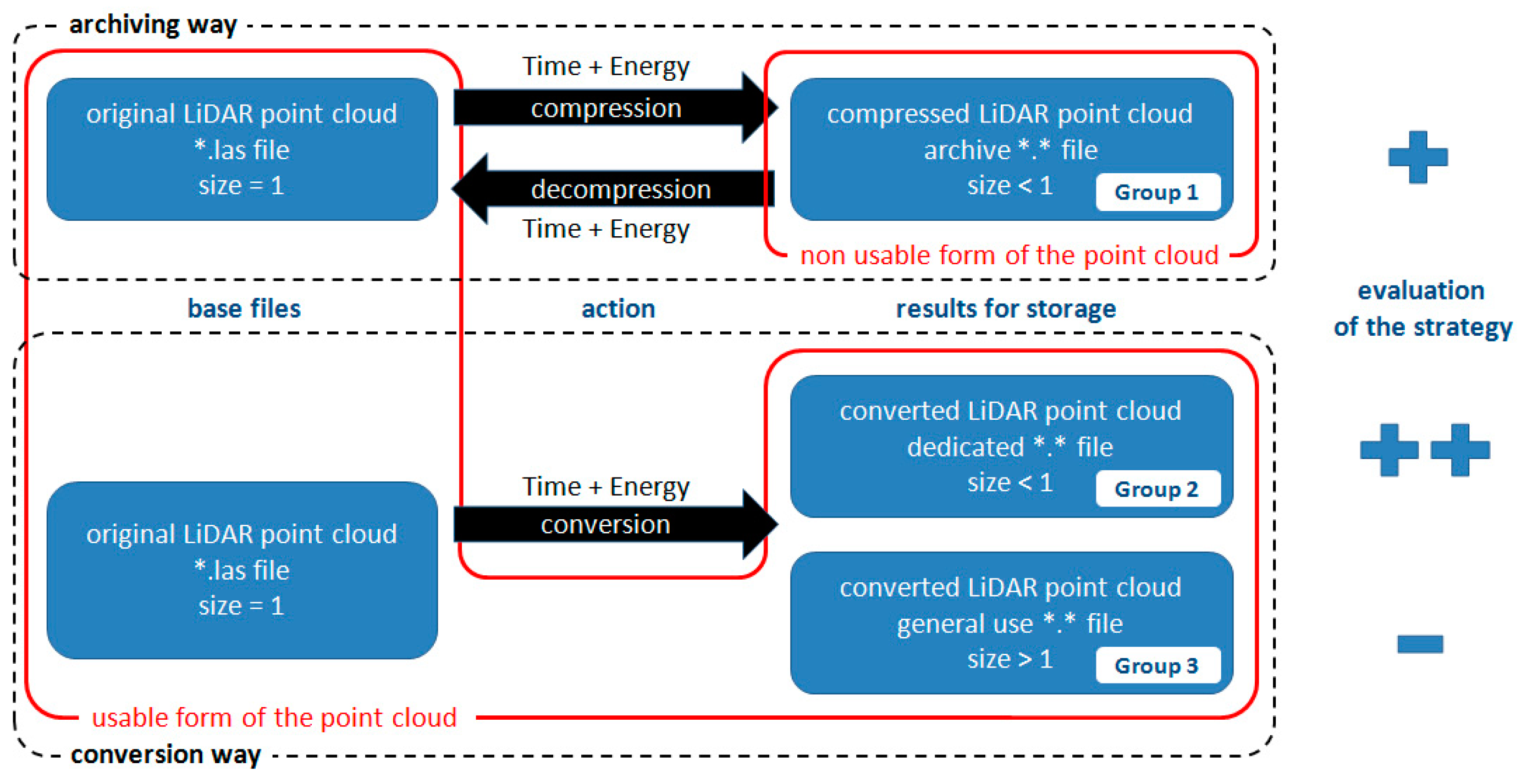
| Name of File | ALS_LOK | ALS_PL2000 | TLS_LOK | TLS_PL2000 |
|---|---|---|---|---|
| Horizontal CS | Local CS | EPSG:2178 | Local CS | EPSG:2178 |
| File format | LAS 1.2 | LAS 1.2 | LAS 1.2 | LAS 1.2 |
| Size of file [byte] | 540,096,009 | 540,096,009 | 623,973,543 | 623,973,545 |
| Number of points | 15,885,170 | 15,885,170 | 23,998,971 | 23,998,971 |
| min X | −600.0000 | 7,474,400.0000 | −135.0189 | 7,474,864.9811 |
| max X | 199.9900 | 7,475,199.9900 | 147.8851 | 7,475,147.8851 |
| min Y | 100.0000 | 5,638,000.0000 | −78.8851 | 5,639,921.1149 |
| max Y | 599.9900 | 5,638,499.9900 | 186.2284 | 5,640,186.2284 |
| min H | 267.2700 | 267.2700 | 115.4018 | 115.4018 |
| max H | 359.5100 | 359.5100 | 184.3779 | 184.3779 |
| min INT | 37 | 37 | 6425 | 6425 |
| max INT | 4404 | 4404 | 65,279 | 65,279 |
| Line | + | + | + | + |
| Echo | + | + | + | + |
| Color (RGB) | + | + | + | + |
| Time (GPS) | + | + | - | - |
| Scanner | + | + | + | + |
| Angle | + | + | + | + |
| Coords Prec. | 0.0001 | 0.0001 | 0.0001 | 0.0001 |
| Span by X | 799.9900 | 799.9900 | 282.9040 | 282.9040 |
| Span by Y | 499.9900 | 499.9900 | 265.1135 | 265.1135 |
| Span by H | 92.2400 | 92.2400 | 68.9761 | 68.9761 |
| Span by INT | 4367 | 4367 | 58,854 | 58,854 |
| Bytes per point | 34 | 34 | 26 | 26 |
| Unit | A | B | C |
|---|---|---|---|
| CPU | 11th Gen Intel® Core™ i5-1135G7 @2.40 GHz 2.42 Ghz (Intel, Santa Clara, CA USA) | AMD Ryzen 5 2600 Six-Core 3.40 GHz (AMD, Santa Clara, CA USA) | Intel(R) Core(TM) i7-7800X CPU @ 3.50 GHz |
| RAM | 8 GB | 32 GB | 128 GB |
| OS | Windows 11 Home 64 | Windows 10 Pro 64 | Windows 10 Pro 64 |
| Type | laptop | PC | PC |
| ALS_LOK | ALS_PL2000 | TLS_LOK | TLS_PL2000 | |||||
|---|---|---|---|---|---|---|---|---|
| CR [%] | CT [s] | CR [%] | CT [s] | CR [%] | CT [s] | CR [%] | CT [s] | |
| min. | 14.95% | 1.0 | 14.95% | 1.0 | 34.97% | 1.0 | 34.08% | 1.0 |
| max. | 402.84% | 2655.0 | 424.92% | 2521.0 | 333.75% | 15,604.0 | 373.24% | 10,149.0 |
| avg. | 51.71% | 87.6 | 52.74% | 85.7 | 57.97% | 227.6 | 58.18% | 172.5 |
| median | 38.54% | 26.0 | 38.40% | 25.0 | 46.28% | 29.0 | 43.39% | 31.0 |
| std. dev. | 46.71% | 270.8 | 50.27% | 257.5 | 39.11% | 1548.0 | 46.96% | 1006.5 |
| Rank | Software | Format and Method | CR | Software | Format and Method | CR | Software | Format and Method | CR | Software | Format and Method | CR | ||||||||
|---|---|---|---|---|---|---|---|---|---|---|---|---|---|---|---|---|---|---|---|---|
| 1 | LASTOOLS | LAZ | 32 | 14.95% | LASTOOLS | LAZ | 32 | 14.95% | 7-ZIP | zip | Ultra | PPMd | 34.97% | 7-ZIP | zip | Ultra | PPMd | 34.08% | ||
| 2 | LASTOOLS | LAZ | 64 | 14.95% | LASTOOLS | LAZ | 64 | 14.95% | 7-ZIP | zip | max | PPMd | 35.75% | 7-ZIP | zip | max | PPMd | 34.91% | ||
| 3 | 7-ZIP | xz | LAZM2 | Ultra | 29.60% | 7-ZIP | 7z | Ultra | LZMA | 29.51% | 7-ZIP | 7z | Ultra | PPMd | 35.98% | 7-ZIP | 7z | Ultra | PPMd | 35.10% |
| 4 | 7-ZIP | 7z | Ultra | LZMA2 | 29.60% | 7-ZIP | zip | Ultra | LZMA | 29.51% | 7-ZIP | 7z | Max | PPMd | 36.27% | 7-ZIP | 7z | max | PPMd | 35.33% |
| 5 | 7-ZIP | 7z | Max | LZMA | 29.64% | 7-ZIP | 7z | Max | LZMA2 | 29.51% | 7-ZIP | 7z | Normal | PPMd | 36.43% | 7-ZIP | zip | Normal | PPMd | 35.34% |
| 6 | 7-ZIP | zip | Max | LZMA | 29.64% | 7-ZIP | xz | LAZM2 | Max | 29.51% | 7-ZIP | zip | Normal | PPMd | 36.52% | 7-ZIP | 7z | Normal | PPMd | 35.39% |
| 7 | 7-ZIP | 7z | Normal | LZMA | 29.65% | 7-ZIP | xz | LAZM2 | Ultra | 29.52% | 7-ZIP | 7z | Fast | PPMd | 37.33% | 7-ZIP | 7z | Fast | PPMd | 35.95% |
| 8 | 7-ZIP | zip | Normal | LZMA | 29.65% | 7-ZIP | 7z | Ultra | LZMA2 | 29.52% | 7-ZIP | zip | Fast | PPMd | 37.51% | 7-ZIP | zip | Fast | PPMd | 36.01% |
| 9 | 7-ZIP | zip | Ultra | LZMA | 29.66% | 7-ZIP | 7z | Normal | LZMA | 29.53% | 7-ZIP | bzip2 | BZip2 | Ultra | 38.06% | 7-ZIP | bzip2 | BZip2 | Ultra | 36.56% |
| 10 | 7-ZIP | zip | Ultra | LZMA | 29.66% | 7-ZIP | zip | Normal | LZMA | 29.53% | 7-ZIP | 7z | Ultra | BZip2 | 38.06% | 7-ZIP | 7z | Ultra | BZip2 | 36.56% |
| LAZ | ZIP | RAR | ||||
|---|---|---|---|---|---|---|
| Isenburg | 15.6% | 50.0% | 22.2% | |||
| Kotb | 16.6% | 39.3% | 20.2% | |||
| AW2014 Poznan | 19.7% | 46.5% | 42.6% | |||
| this research | ||||||
| ALS | 14.9% | 33.3% | 34.0% | 44.3% | 39.8% | 38.3% |
| TLS | 41.8% | 42.7% | 43.8% | 53.3% | 42.9% | 45.5% |
| from LASTOOLS | from TRW | from 7-ZIP | from WINRAR | RAR from WINRAR | RAR4 from WINRAR | |
Disclaimer/Publisher’s Note: The statements, opinions and data contained in all publications are solely those of the individual author(s) and contributor(s) and not of MDPI and/or the editor(s). MDPI and/or the editor(s) disclaim responsibility for any injury to people or property resulting from any ideas, methods, instructions or products referred to in the content. |
© 2024 by the authors. Licensee MDPI, Basel, Switzerland. This article is an open access article distributed under the terms and conditions of the Creative Commons Attribution (CC BY) license (https://creativecommons.org/licenses/by/4.0/).
Share and Cite
Warchoł, A.; Pęzioł, K.; Baścik, M. Energy-Saving Geospatial Data Storage—LiDAR Point Cloud Compression. Energies 2024, 17, 6413. https://doi.org/10.3390/en17246413
Warchoł A, Pęzioł K, Baścik M. Energy-Saving Geospatial Data Storage—LiDAR Point Cloud Compression. Energies. 2024; 17(24):6413. https://doi.org/10.3390/en17246413
Chicago/Turabian StyleWarchoł, Artur, Karolina Pęzioł, and Marek Baścik. 2024. "Energy-Saving Geospatial Data Storage—LiDAR Point Cloud Compression" Energies 17, no. 24: 6413. https://doi.org/10.3390/en17246413
APA StyleWarchoł, A., Pęzioł, K., & Baścik, M. (2024). Energy-Saving Geospatial Data Storage—LiDAR Point Cloud Compression. Energies, 17(24), 6413. https://doi.org/10.3390/en17246413