1. Introduction
In today’s dynamic and complex world, the energy sector plays a crucial role, and the management of infrastructure assets is critical for the sector to operate effectively [
1,
2]. In this context, the concepts of asset management, land management, pipelines, and spatial standards are closely related and play an important role in enhancing the operational efficiency of the energy sector [
3,
4,
5,
6]. Asset management ensures the effective management of energy infrastructure assets, which includes processes such as design, planning, maintenance, and decommissioning [
7,
8,
9]. Pipelines are typically located in landscapes spread over long distances; therefore, land management is necessary for the safe and effective construction, maintenance, and operation of pipelines [
10,
11]. Land management involves obtaining appropriate permits, negotiating agreements with landowners, and complying with environmental regulations. Pipelines play a critical role in transporting energy resources and are found across different types of terrain over long distances. Therefore, spatial standards are vital for the monitoring and management of pipelines using Geographic Information System (GIS) technologies [
12,
13,
14].
Geographic information is estimated to constitute approximately 80% of all information and is considered to be effective in 90% of decision-making mechanisms [
15]. Both the public and private sectors increasingly recognize that geographic information is a vital component for effective decision-making. In this context, standards play an important role. Standards are fundamental in providing geographic services and products that meet the needs of a broader user community, providing significant value to society and the government [
16]. Reliable information about the locations of linear infrastructure such as water pipelines, power lines, gas pipelines, oil pipelines, roads, and bridges is vital for the planning and management of these areas. Infrastructure management tasks such as property management, land acquisition, planning, and operation depend on the availability of reliable and high-quality information.
The asset management information system includes decision support tools that identify aging assets and indicate when assets need to be renewed or replaced or when new assets need to be acquired. Ideally, asset information can be stored initially using less costly tools such as electronic spreadsheets or basic CAD (Computer-Aided Design) softwares that can be easily adapted to the needs of the information system, and then stored in a GIS program that is established for easy access to information [
17]. (Building Information Modeling) BIM integrates with GIS to support applications where buildings, road networks, and underground facilities are interconnected and used for analysis in larger-scale areas such as urban regions [
18]. BIM is a new industry term that refers to parametric 3D CAD technologies and processes used in the architecture, engineering, and construction (AEC) industry [
19]. Over the past two decades, BIM has played a central role in the development of the construction industry. However, there is a noticeable research gap in utilizing BIM for both urban and city development management. The limitations of BIM concerning horizontal expansion triggered its integration with GIS to overcome these restraints and start leveraging the benefits of BIM regarding city development processes [
20].
Land management is defined as the process conducted by the administration using public or private sector organizations related to land ownership, land value, land use, and land development [
21]. In land administration, the use of geographic information and data standards can contribute to preventing inconsistencies among data held by different organizations to support infrastructure management. Standardization can play a supportive and complementary role in the development of land management systems and infrastructure management. The diversity of processes owned by stakeholders in infrastructure management requires a procedure to ensure consistency within the same sector. The data model to be established for ensuring infrastructure management can be designed to support this consistency.
In the energy sector, physical infrastructure is constructed and operated with large budgets. The global oil and natural gas industry, between 2018 and 2022, generated revenues of nearly USD 3.5 trillion annually, including the revenue from crude oil and natural gas production, as well as the value created from processing, refining, transporting, and marketing final products to consumers. Considering the effects of the COVID-19 pandemic, this figure experienced significant fluctuations from a low level of around USD 2 trillion in 2020 to a historic record level of USD 5 trillion during the global energy crisis in 2022. In 2023, total energy investment was estimated to be USD 2.8 trillion. Approximately USD 1.8 trillion of this will be invested in clean energy, and USD 1 trillion will be invested in oil, gas, and coal (including extraction, refining, transmission and distribution, and power plants using these fuels) [
22].
In recent years, concepts such as land management, infrastructure and construction management, and project management have emerged as concepts that need to be managed with a multidisciplinary perspective in order to manage limited resources efficiently. Although digitalization initiatives have begun to show effectiveness, especially in building construction, the expected progress has not yet been achieved in linear infrastructure. Meeting the requirements of asset management and promoting digital transformation is possible with a common information system for linear infrastructure construction projects such as pipelines, roads, and railways [
18,
23,
24].
Pipelines play a vital role in the energy and infrastructure sectors. Developing a pipeline infrastructure involves a complex design process that includes both capital expenditures (CAPEX) and operational expenditures (OPEX) [
25]. There is a growing interest in addressing inefficiencies in the CAPEX and OPEX expenditures of pipeline infrastructures through digital systems. The integration of BIM and GIS for the management of natural gas pipelines and the lifecycle processes of related infrastructure assets can provide a feasible basis.
This study comprehensively reviews the literature on the “bibliometric analysis” method to guide researchers working on the integration of both BIM and GIS in asset management in the natural gas pipeline infrastructure sector. The current status and practical applications of BIM-GIS integration are summarized from perspectives such as infrastructure project lifecycle applications, land management, data integration, and standardization technologies. Additionally, a roadmap is proposed to enhance the integration of asset management, BIM, and GIS further and to expand sustainable application areas, considering current research gaps and future trends.
2. Conceptual Framework
The conceptual framework of this study focuses on the concepts of effective asset management, infrastructure management, data integration, and data standardization for the comprehensive management of natural gas pipeline infrastructure. These concepts are critical for the economic and technical sustainability and efficiency of infrastructure. Physical assets generally represent structures such as roads, pipes, valves, transmission lines, transformer stations, valves, and pipelines for transportation, water, electricity, gas, and oil [
26,
27,
28]. Asset management plays a central role in infrastructure management and requires decision-making based on accurate data. Infrastructure management refers to the management principles of essential infrastructures such as transportation, water, electricity, gas, and oil that people need in their lives and the directly related physical infrastructure [
29,
30]. Data integration involves the collection, processing, and analysis of data from different sources, while data standardization pertains to standardizing data formats and structures [
31,
32].
This section describes the concepts considered during the systematic literature review on the integration of BIM and GIS for asset management in natural gas pipelines. Data integration is a key process in this framework, encompassing the collection, processing, and analysis of data from diverse sources to provide a comprehensive view of the infrastructure. Data standardization is equally important, ensuring that data are formatted and structured in a consistent manner, facilitating effective analysis and decision-making. Together, these concepts form the foundation for the effective management of natural gas pipeline infrastructure, supporting its economic and technical sustainability and efficiency. In this context, it is important to convey some key concepts related to the subject.
2.1. Physical Assets
Physical assets are items such as facilities, machinery, buildings, roads, vehicles, railways, airplanes, pipelines, wires, communication equipment, and other infrastructure. The ISO 55000 asset management standard defines an asset as “an item, thing or entity that has potential or actual value to an organization”. This definition is very general and can encompass all types of assets. Furthermore, different types of assets can be identified within organizations in different industries, including physical assets, financial assets, human assets, information assets, and intangible fixed assets [
33].
Table 1 lists the ISO 5500x series standards and their brief contents. The ISO 5500x standard series evolved from a British standard published in 2004 [
34] and aims to manage various types of assets in different sectors. It can be used in various fields such as infrastructure, public services, capital-intensive industries, real estate, and service organizations. In addition to physical assets, financial, human, and information assets are also considered to the extent that they support the management of physical assets. Intangible assets are non-physical assets such as goodwill and intellectual property.
Asset management is the coordinated activities of an organization that are based on the ISO 55000 Standard Series [
36] to obtain value from assets. An asset is an item, thing, or entity that has potential or actual value to an individual or organization by providing a service. The overall objective is to minimize the total cost of ownership of assets. However, other critical factors such as risk or business continuity may also need to be objectively assessed. Asset management also allows for the application of analytical approaches at different stages of an asset’s lifecycle, including design, implementation, management maintenance, and decommissioning [
37,
38]. Asset management is therefore multifaceted when considering the strategic and operational aspects of an organization’s asset portfolio. In today’s economies, the effective management of physical assets such as natural gas pipeline infrastructures has become more important for reducing costs and risks and ensuring environmentally and socially sustainable and safe operations.
2.2. Infrastructure Management
Infrastructure management uses a standardized holistic approach to coordinate a physical working environment, an organization’s employees, and functions. It also combines the principles of business management and engineering sciences. Therefore, infrastructure management represents a complex field involving different processes requiring broad integration to deliver effective service [
39].
Infrastructure systems in urban areas are closely located, intertwined, and interconnected. Therefore, maintenance activities carried out in one infrastructure system can disrupt the operation of another infrastructure system [
40]. Dependencies among infrastructure systems exist not only in negative and emergency situations but also during the routine use of infrastructure systems. These dependency relationships in linear engineering structures such as roads, water channels, pipelines, and electricity transmission lines are intertwined with all other land elements. The work performed for the construction and operation of these infrastructures is an important part of land management.
Infrastructure management is strategically positioned for the economic and social development of countries and, most importantly, for the quality of life and social development of citizens. Infrastructure management is necessary to maintain and improve a high standard of living for many reasons. For example, it ensures safety in production activities and can also help protect the environment through more rational and long-lasting use of all production resources. Effective infrastructure management encourages the preservation of civil and industrial assets as fundamental components of economic sustainability [
41].
Advanced countries actively apply asset management techniques that integrate management and economic techniques in engineering processes to maximize the functions of infrastructure while minimizing costs. Various standard processes for asset management are found in the general asset management guides of these advanced countries, intended for use by authorities [
42].
Effective innovation systems secure incentives for utilizing public expenditures, intellectual property rights, knowledge networks, market opportunities, and private sector capital. Particularly in the last decade, cheap capital has reduced barriers to long-term risky investments, thus masking weaknesses in innovation systems. As the cost of money begins to rise, the health of these systems will be a critical determinant of whether new technology ideas and decarbonization scenarios continue. Compared with other parts of the energy sector, investment in innovation reflects a balance between long-term thinking and short-term shocks [
43].
With the increasing demand for investments in infrastructure and sustainability, there is a need to create asset management guides for measuring the performance of infrastructure asset management. This includes producing the necessary standards and technical documents for collecting sector-specific data and ensuring the integration of these data.
2.3. Spatial Data Infrastructure
Spatial information is increasingly recognized as a fundamental element in decision-making processes for many disciplines. Spatial information provides a spatial/geographical context to planning, management, and resource allocation processes, enabling a better understanding and hence better management of an area. In this context, many countries worldwide are developing spatial data infrastructures (SDIs) to better manage and share their spatial data assets [
44,
45].
SDIs consist of policies, standards, and procedures that facilitate the more efficient use, management, and production of geographic data by organizations and technologies interacting with geographic data [
46]. Some of the benefits of developing SDIs include better access to data, less redundant effort in data collection and maintenance, improved usability of data, and interoperability among datasets.
SDIs exist at local, regional, national, and global levels [
47,
48]. Additionally, it is possible to identify topic-based and community-focused spatial data infrastructures [
49]. Examples of these infrastructures include coastal area management, transportation management, disaster management, agricultural management, energy management, and so on.
SDI components, such as standards, policies, and technology concepts between spatial data and users, are presented in
Figure 1. The policy component requires legal regulations for establishing institutional structures, data sharing, and pricing. As for technology, the establishment of GIS servers and portals that enable access to/share data through communication networks is necessary. To ensure the interoperability of data, the standard component requires defining data models, metadata, and data exchange standards [
47]. According to the Global Spatial Data Infrastructure Association (GSDI Association), the first stage in implementing SDI is to make geographic data suitable for multi-purpose use [
50]. In other words, initially determining data standards and data models makes the geographic data to be produced and used in various application areas [
51].
Another important component of asset management is the generation, storage, and management of information about physical infrastructure assets. For infrastructure management, the characteristics of physical assets as objects, their relationships and interactions, and the behaviors they exhibit when evaluated as a network are critically important for effective asset management.
Data integration is the process of combining data from different sources to create a consistent, holistic, and meaningful view. Data integration is especially important for organizations dealing with large and complex datasets. This process plays a critical role in maintaining data integrity, conducting data analysis, and making effective decisions [
51].
2.4. Spatial Data Standardization
Standardization involves providing a framework for managing the assets, metadata, and semantics of a system through a standardized procedure [
52]. Standards developed for data integration are widely used to create conceptual models because of their ability to enhance efficiency and facilitate communication among information systems based on a common language. Standardization also provides important tools for managing physical assets. Data integration is at the core of organizations’ data management strategies and is critical for achieving more effective business outcomes.
In various countries or regions, geographic data standards have been developed to ensure the production, sharing, and common use of geographic information according to specific norms. Examples of country-specific spatial data infrastructures include The National Spatial Data Infrastructure (NSDI) in the United States, the Turkish National Spatial Information System (TUCBS) in Turkey, the Canadian Geospatial Data Infrastructure (CGDI) in Canada, the Geo-spatial Data Infrastructure for Germany (GDI-DE) in Germany, the New Zealand SDI in New Zealand, the SDI of France in France, and the Norway Digital-Norwegian Spatial Data Infrastructure (NO) in Norway. At the regional level, examples include the Infrastructure for Spatial Information in Europe (INSPIRE) Directives established within the European Union and the Arctic Spatial Data Infrastructure (Arctic SDI). Local and regional spatial data infrastructures support various applications such as infrastructure management or disaster risk assessments. These data infrastructures enable access to more specific and detailed information at the local level.
Because of the nature of geographic information, it is linked to other sector standards through technical connections such as geographic information standards, coordinate reference systems, scale, data formats, web services, and ontologies. These connections enable data sharing and collaboration in different sectors. Standards produced by organizations such as the International Organization for Standardization (ISO), the International Electrotechnical Commission (IEC), the European Committee for Standardization (CEN), the Open Geospatial Consortium (OGC), the American Society for Testing and Materials (ASTM International), the American Society of Mechanical Engineers (ASME), and the American Petroleum Institute (API) at national, regional, and international levels are related to geographic data. In particular, the ISO 55000 Asset Management Standard is directly related conceptually to the sector standards mentioned, as it is more concerned with physical asset management. The integration of these standards is necessary for optimal pipeline infrastructure management. The integration of geographic data standards and other sector standards will establish a spatial data infrastructure critical for optimal pipeline infrastructure management. This integration will contribute to more effective and sustainable infrastructure planning and decision-making processes by increasing data sharing and interoperability.
2.5. BIM and GIS Integration
The integration of Building Information Modeling (BIM) and a Geographic Information System (GIS) leverages the complementary strengths of both BIM and GIS in the context of smart cities and digital twins, combining BIM techniques with GIS techniques [
53]. While BIM serves as a resource for building object information, GIS provides powerful analytical capabilities and geographically referenced data [
54].
Industry Foundation Classes (IFC) is an open data standard based on EXPRESS, initiated by buildingSMART in 1994 to facilitate information interoperability in the construction sector. It is an object-based integrated model schema used to integrate information required by relevant stakeholders. Supported by most BIM softwares in the AEC industry, IFC is considered the most popular BIM standard [
55,
56]. On the other hand, CityGML is a GIS standard developed by the Open Geospatial Consortium (OGC). It was officially adopted as an OGC standard by OGC members in 2008. CityGML has the capability to represent 3D models in XML (Extensible Markup Language) format [
55,
56].
Data matching between IFC and CityGML can be challenging because of the fact that these two schemas are proposed for different purposes. While IFC attempts to capture all relevant information related to a building, CityGML models are often used to reference maps or the geometry of buildings. IFC has a structure defined by references to line numbers in an EXPRESS-based format, whereas CityGML uses an XML-based schema utilizing XML Schema Definition (XSD) to define relationships among entities. Considering the large number of entities and differing structures of the schemas, an instance-based examination of entities in both schemas is preferred. Additionally, since IFC contains much more information than CityGML, extending the CityGML schema would be necessary for seamless information exchange [
56].
Although both BIM and GIS provide digital representations of architectural or environmental assets, their focus areas differ. BIM primarily focuses on construction projects and their internal details, that is, on relatively micro-level data; GIS, however, is used to generate macro-level information such as topographic terrains. Despite focusing on their specific characteristics and traits, the integration of BIM and GIS remains inadequate. The current challenge primarily arises from the inability to fully convert data between BIM and GIS models [
57].
3. Methodology
3.1. Research Topic and Objective
The aim of this study is to conduct an in-depth review of the existing literature on asset management, pipeline infrastructure management, and BIM-GIS integration to identify research trends and significant gaps in these areas. This study uses bibliometric analysis to visualize general information about the studies, identify leading journals, highlight keywords, and determine research trends. A systematic literature review is used to comprehensively scan the existing sources and identify sources relevant to this study’s objectives. The results aim to highlight future research trends in asset management, linear infrastructure management, and BIM-GIS integration, particularly emphasizing the importance of data standardization, digitalization, systematic integration, and contemporary land management for sustainable natural gas pipeline infrastructure design, construction, and management. This study aims to pave the way for further research in these areas and enhance knowledge in the field of natural gas pipeline infrastructure management.
This study aims to provide researchers in asset management, infrastructure management, and related fields with a perspective on data integration and data standardization in the natural gas pipeline sector. It is expected to contribute to theoretical and practical studies based on this work. To achieve these goals, this study seeks answers to the following research questions:
What are the trends in the asset management literature?
What are the academic trends related to the current research considering scientific production, the evolution of trends, and main themes?
What methods are used in asset management research related to natural gas pipeline infrastructure and similar infrastructures?
What relationships can be established between the current literature and future research?
3.2. Research Methodology
Bibliometric analysis provides a broad perspective for examining the dynamics of a research field by displaying knowledge clusters, the historical development of themes, the most frequently used terms in published materials, and similar information [
58,
59]. Bibliometric analysis aims to characterize findings quantitatively rather than examining them in the literature [
60,
61]. In this study, the bibliometric analysis method is chosen to systematically evaluate the field of asset management and analyze its developments, impacts, and trends.
Bibliometrics can be used to reveal and evaluate the performance of disciplines, journals, authors, institutions, and countries. It can also be used to assess patterns such as author collaboration, institutional collaboration, and country or region collaboration. This can help scientists and researchers understand the diversity of research themes, the latest developments, pioneering themes, and the research areas geographically in terms of content in a specific field. Despite being complex in terms of analysis, bibliometric analysis has been used in different research fields to analyze a large amount of the existing literature quantitatively and identify developments in the field [
61,
62].
The systematic literature review is another popular review technique used to determine research focal points critically among articles in a field. It has been used by academics in many fields. The combination of bibliometric and systematic literature reviews has gained popularity in review studies [
63].
In this study, the reliable, popular, and comprehensive academic publication database Scopus was selected because it offers a wide range of publications through various query attempts. Scopus enables the use of bibliometric analysis by providing data on the profiles of scientific research, thus providing clues about collaboration among publications [
64]. After determining the necessary search criteria to distinguish scientific articles including asset management in Scopus, software including Biblioshiny (4.0) [
65] and VOSviewer (1.6.20), which are based on the R programming language, were used to perform the bibliometric analysis. The studies included in the analysis were filtered based on historical, linguistic, and type criteria. Since the year 2024 had not yet ended at the time this study was prepared, studies published in 2024 could not be included in the analysis.
3.3. Bibliometric Data Analysis
To perform bibliometric analysis systematically, the PRISMA flowchart, which is commonly used in the literature for systematic literature reviews and meta-analyses [
66,
67,
68], was utilized. The PRISMA guidelines were followed to conduct the literature review part of this study systematically. PRISMA provides steps to follow to access the necessary sources in bibliometric analyses. Accordingly, the steps in
Figure 2 were followed.
Scopus is a scientific, multidisciplinary, and international literature bibliographic database created by Elsevier in November 2004 [
69]. It covers articles and other research materials from a wide range of disciplines, including scientific, technical, medical, and social sciences. Scopus’s comprehensive database and various analysis tools allow it to be used in many areas, such as evaluating scientific research, analyzing trends, and discovering collaborations and networks.
In the data collection process, the keywords “asset management” were used to determine the scope of this study. For this purpose, the following query was conducted in the Scopus database in January 2024, and 16,742 publications were obtained.
“TITLE-ABS-KEY (asset AND management) AND PUBYEAR > 2013 AND PUBYEAR < 2024 AND (LIMIT-TO (PUBSTAGE, “final”)) AND (LIMIT-TO (DOCTYPE, “ar”)) AND (LIMIT-TO (LANGUAGE, “English”))”.
This search was primarily conducted in the title, abstract, and author keywords fields. The studies were limited by language, date, and type. Following this limitation, studies up to the year 2023 in the English language and article type were filtered and prepared for bibliometric analysis.
Data related to the articles were exported from the Scopus database in “.csv” format for bibliometric analysis. The generated file was edited using the Excel (1808) program. Biblioshiny, a software based on the R programming language, was used for bibliometric analysis [
65]. Biblioshiny is designed as a scientific mapping program and enables various bibliometric network analyses such as keyword co-occurrence analysis, co-authorship analyses, and visualization of citation networks.
3.4. Limitations of this Study
The Scopus database was used for bibliometric research and the subsequent systematic literature review. Although Scopus is one of the largest bibliographic databases, it does not cover all scientific publications. Since bibliometric studies are directly influenced by the choices made regarding search terms and limitation criteria, they are subjective. Additionally, there may be potential issues related to the use of keywords in publications in the Scopus database for bibliometric analyses. These aspects constitute the limitations of bibliometric research.
4. Bibliometric Analysis Findings
This section presents general information about the 16,737 publications included in the bibliometric analysis, their distributions over the years, the most cited authors, the journals with the highest number of publications, and findings related to the most studied concepts in the field up to the present day. General information regarding the analysis results is provided in
Table 2.
Table 2 contains the general findings about the publications on asset management. It is observed that research on asset management has been ongoing between 2014 and 2023, indicating sustained interest in the topic. The 16,737 articles were published in 4560 different sources, indicating that various aspects of the subject have been examined. The average age of the articles was calculated as 4.85 years, indicating that the research is generally recent and focused on current developments. On average, each article received 12.75 citations, indicating that the studies have made significant contributions to the field of asset management and are frequently referenced by other researchers.
Looking at
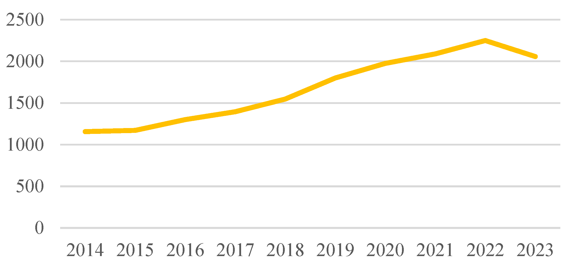
Figure 3, it can be observed that there is a steady increase in the number of publications from 2014 to 2015, and a significant increase in the number of studies can be seen from 2016 onwards. The upward trend in the number of studies on the subject continues. Although there is a decrease in the number of publications published in 2022 and 2023, overall, the graph indicates that research in the field of asset management remains current.
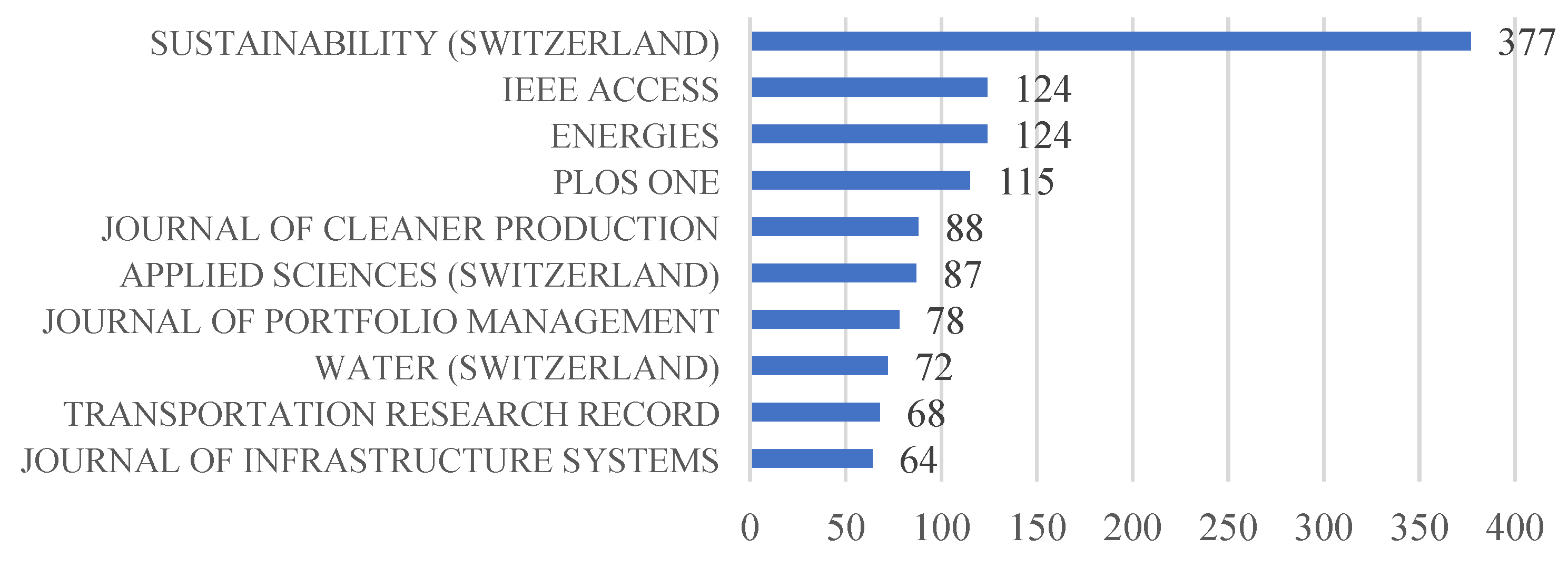
Figure 4 shows the most frequently published sources of articles on asset management. Researchers have generally preferred these journals to publish their studies.
Sustainability (Switzerland) stands out as the journal with the most publications in the field of asset management, with a total of 377 publications. It can be said that the journals are predominantly related to infrastructure, transportation, energy, water infrastructure, and similar fields. However, it can also be stated that the nature of asset management inherently exhibits a multidisciplinary character, encompassing areas such as sustainability, infrastructure, and production.
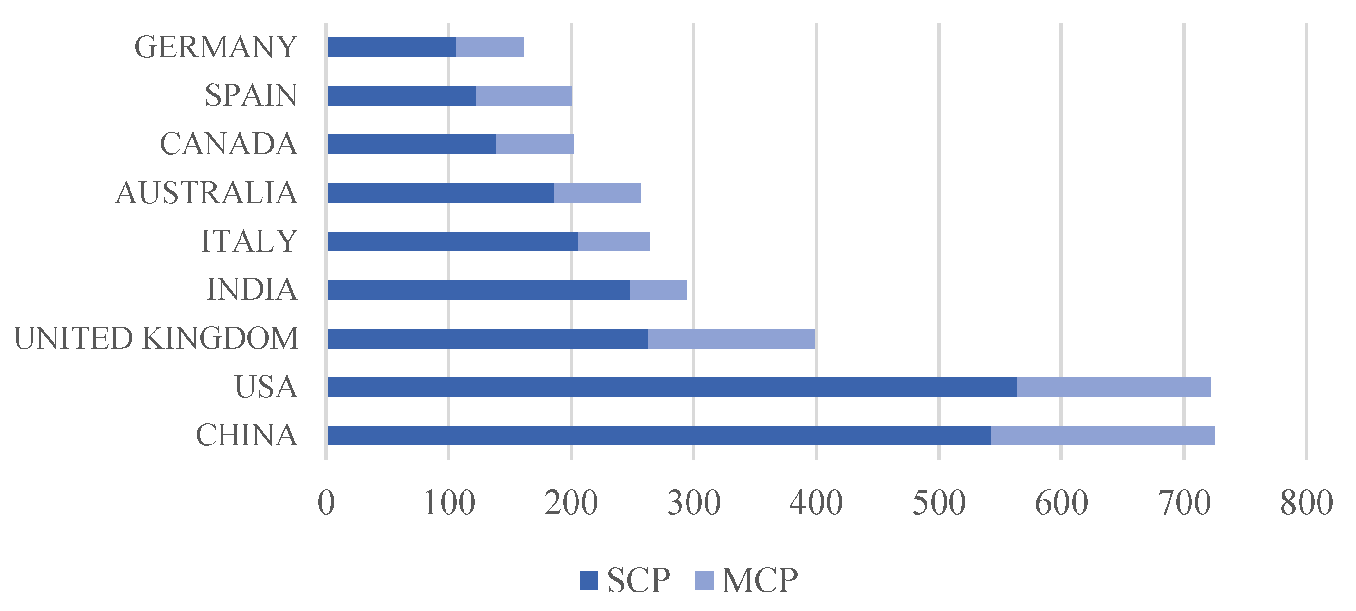
Figure 5 shows the countries of the corresponding authors of the publications. Articles published by researchers in the same country are shown as SCPs (Single-Country Publications), while articles published by researchers from multiple countries are shown as MCPs (Multiple-Country Publications). The sum of an individual country’s SCP and MCP values represents the total number of articles produced in that country [
65]. In light of all this information, it can be seen that the country contributing the most is the People’s Republic of China, which is also ranked first. The United States ranks second, the United Kingdom ranks third in the table, and Germany is in last place.
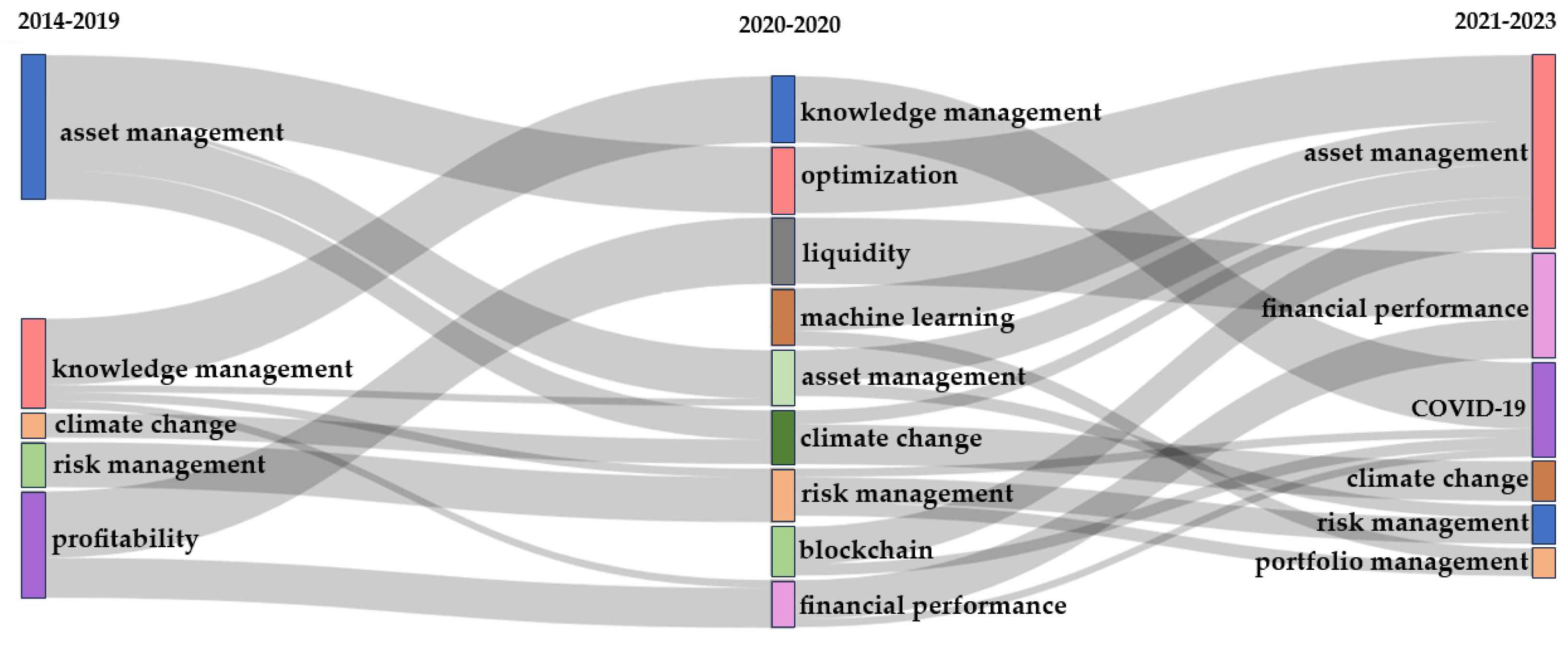
Thematic evolution is the visualization of the presence of concepts in a particular research field over different time periods and the determination of how these concepts are related to each other. Sankey diagrams are used to create these graphics. Sankey diagrams are commonly used to visualize quantitative information that includes flows, relationships, and transformations in processes [
70,
71]. In the graphic, each concept is represented by rectangles, and their sizes are scaled according to the frequency of occurrence of the respective theme. Additionally, the gray connections among the rectangles allow for the evolution of the theme to be observed. The degree of connection between two related themes determines the thickness of the connection line. When looking at different time intervals, some themes remain unchanged, some themes disappear, and some themes evolve together to form a new theme [
72,
73,
74].
Figure 6 depicts the thematic evolution of concepts covered in this study between 2014 and 2023. The concept of asset management, which is the focus of this bibliometric analysis, along with knowledge management, climate change, risk management, and profitability, has been highlighted. Following the transformations after the COVID-19 pandemic, some evolutions have occurred in these concepts. The concept of asset management has evolved into optimization, asset management, and climate change. The concept of knowledge management has evolved into asset management, risk management, and financial performance. In addition to these evolving concepts, the concepts of machine learning and blockchain have emerged. Currently, the concepts of COVID-19 and asset inventory management have emerged. Throughout this evolving process, asset management has gone through a process that requires a focus on financial efficiency, risk management, and asset inventory.
According to the graph presented in
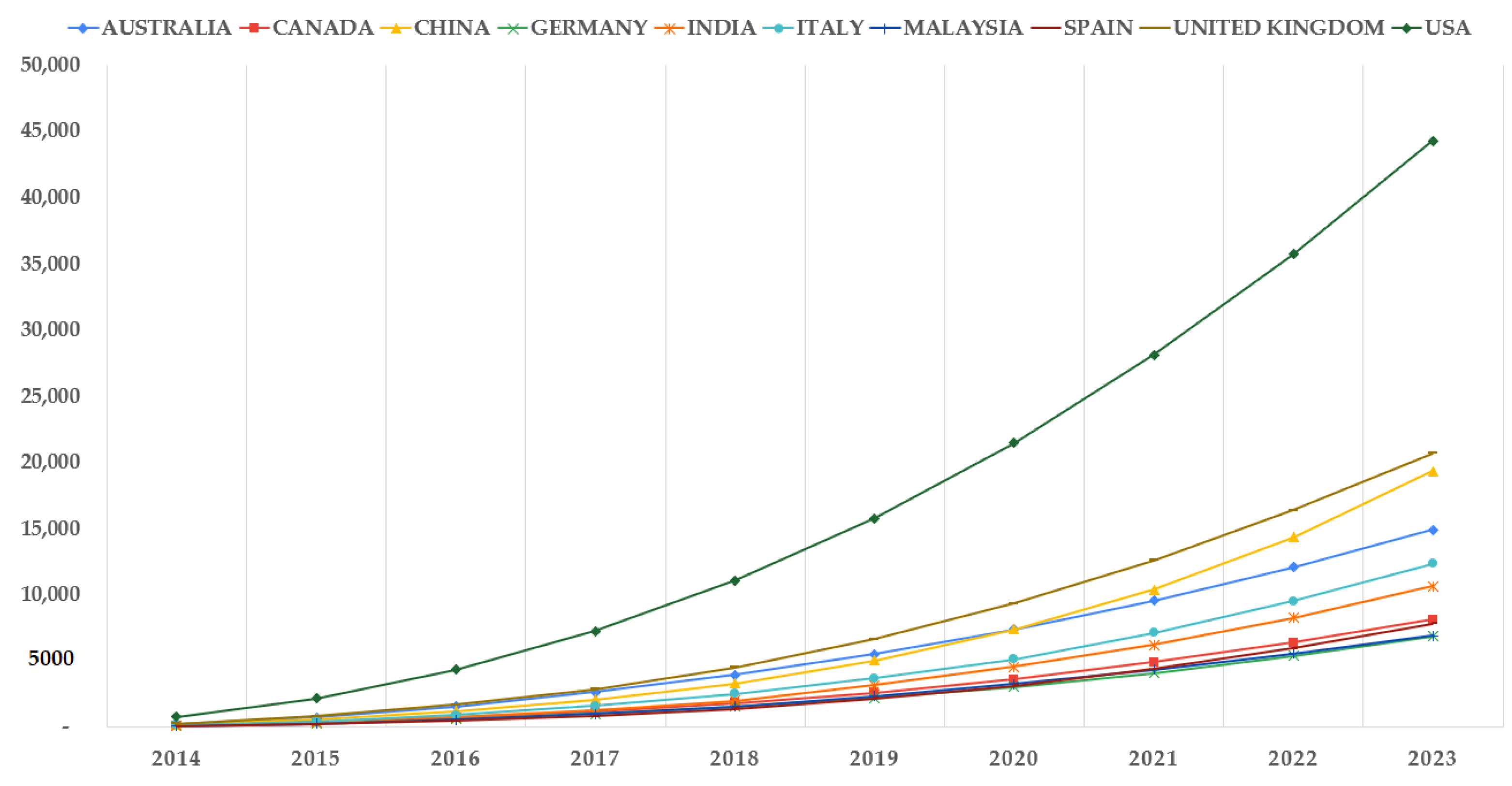
Figure 7, the United States is clearly the leader in the number of articles produced on asset management in the years studied. The United Kingdom and the People’s Republic of China have seen a significant increase in the pace of article production, especially after 2019. Other countries have continued to produce articles at a steady pace.
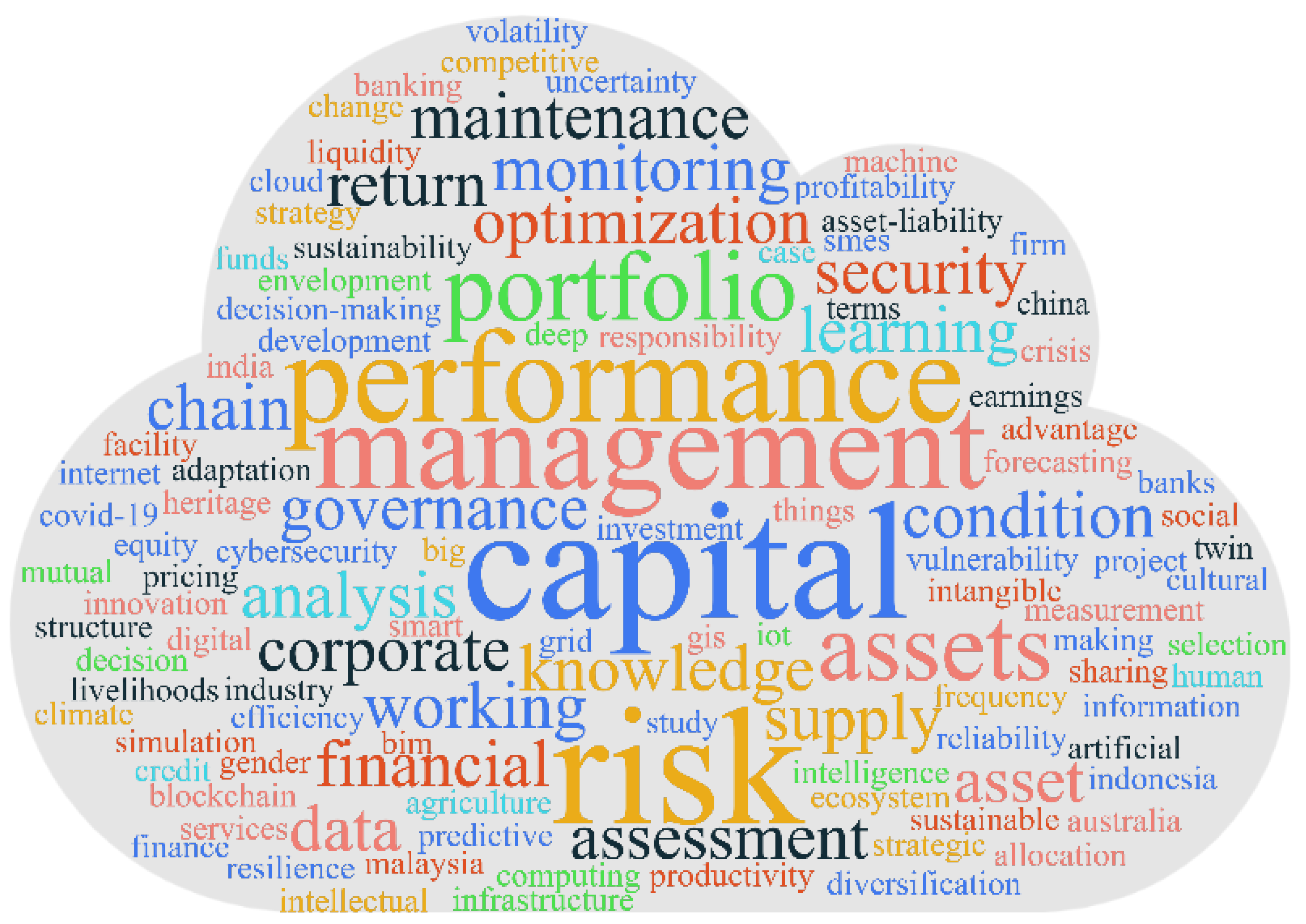
Word clouds are graphs that visually represent the most frequently used words in a text or study. These graphs help to show the focus points, themes, and important concepts of the text or study. The sizes of the words in word clouds are determined according to their frequency of use. More frequently used words are shown larger, while less frequently used words are shown smaller.
Figure 8 shows the most frequently used keywords in studies related to asset management. When the word cloud is examined, it is seen that the concepts of “risk”, “investment”, “performance”, “management”, “assets”, “information management”, “asset portfolio”, “audit”, “optimization”, and “maintenance” are particularly heavily covered in the publications.
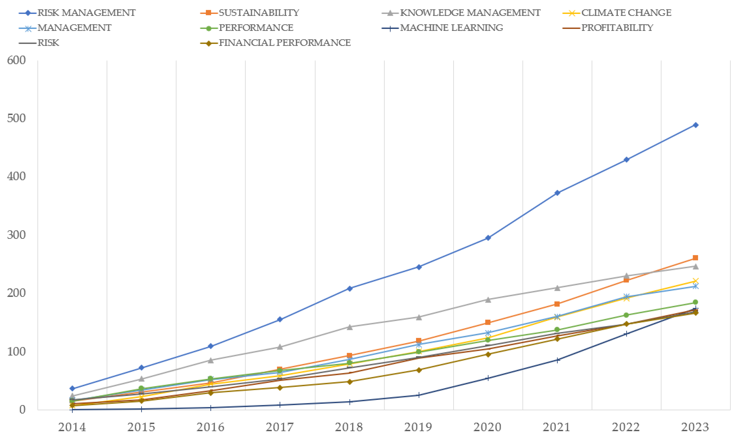
Figure 9 shows the usage of keywords used in publications on asset management by year. It is seen that research on risk management has gained momentum, especially in 2020 and beyond, with the effects of the COVID-19 pandemic. The figure reveals that publications about machine learning increased in 2019 and beyond. When we look at the word frequency statistics in general, it is seen that research related to asset management has gained popularity in recent years and the momentum of increase is increasing. In this case, concepts such as performance management, sustainability, and financial performance, which are related components, have also gained momentum. Global climate change has also contributed to the increase in research on risk management, financial efficiency, and sustainability.
In this study, a total of 39,847 author keywords were collected from 16,737 articles published in the field of asset management between 2014 and 2023.
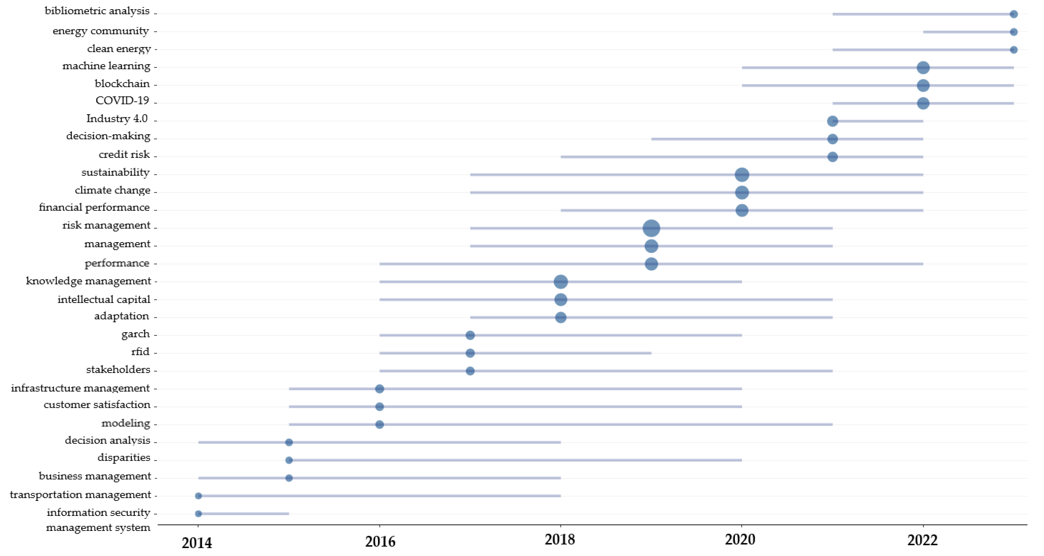
Figure 10 is a graphic showing historical stacks of the most used keywords by authors. The x-axis in the graph shows the years, and the y-axis shows the keywords used in the studies. The horizontal lines in the graph represent the usage period of the terms, while the blue dots show the average of the years of research corresponding to the relevant keywords. The size of the points on the graph indicates the frequency of use of the relevant keyword.
In the chart, the concepts of modeling and performance stand out as the most frequently used concepts over time. This situation shows the abundance of research on performance in asset management and modeling in asset management. On the other hand, the concepts of intellectual capital, sustainability, and climate change also stand out as temporal usage. The concepts that stand out numerically in the publications can be listed as risk management, knowledge management, sustainability, climate change, and financial performance.
In recent years, the concepts of Industry 4.0, COVID-19, blockchain, machine learning, clean energy, energy community, and bibliometric analyses have come to the fore. Nowadays, it is observed that current research on these subjects is increasing. When we look at this graph in general, it is understood that more emphasis is given to data interpretation and analysis of complex data rather than data collection. In addition, efficiency and sustainability themes come to the fore in data management and financial management of asset management.
The publications resulting from the query made for bibliometric scanning were filtered to include the words “natural gas”. The purpose of the filtering process is, within the results obtained through bibliometric analysis, to present and examine the existing literature in the field of physical asset management, data integration and standardization, and natural gas pipeline management, which are topics that are not mentioned or emphasized within the scope of asset management. As a result of this review, it is seen that there is a significant research gap within the scope of asset management, especially in the field of natural gas pipelines. For the bibliometric analysis, among the 16,742 articles found as a result of the “asset management” query, 668 studies were found by filtering with the words “natural gas”, and 46 articles related to “natural gas pipeline” were selected for the literature review.
5. Systematic Literature Review Findings
Within the scope of asset management, 46 articles related to natural gas pipelines were examined. When we look at the literature in general, it is seen that the majority of studies are on water lines and water-related infrastructures.
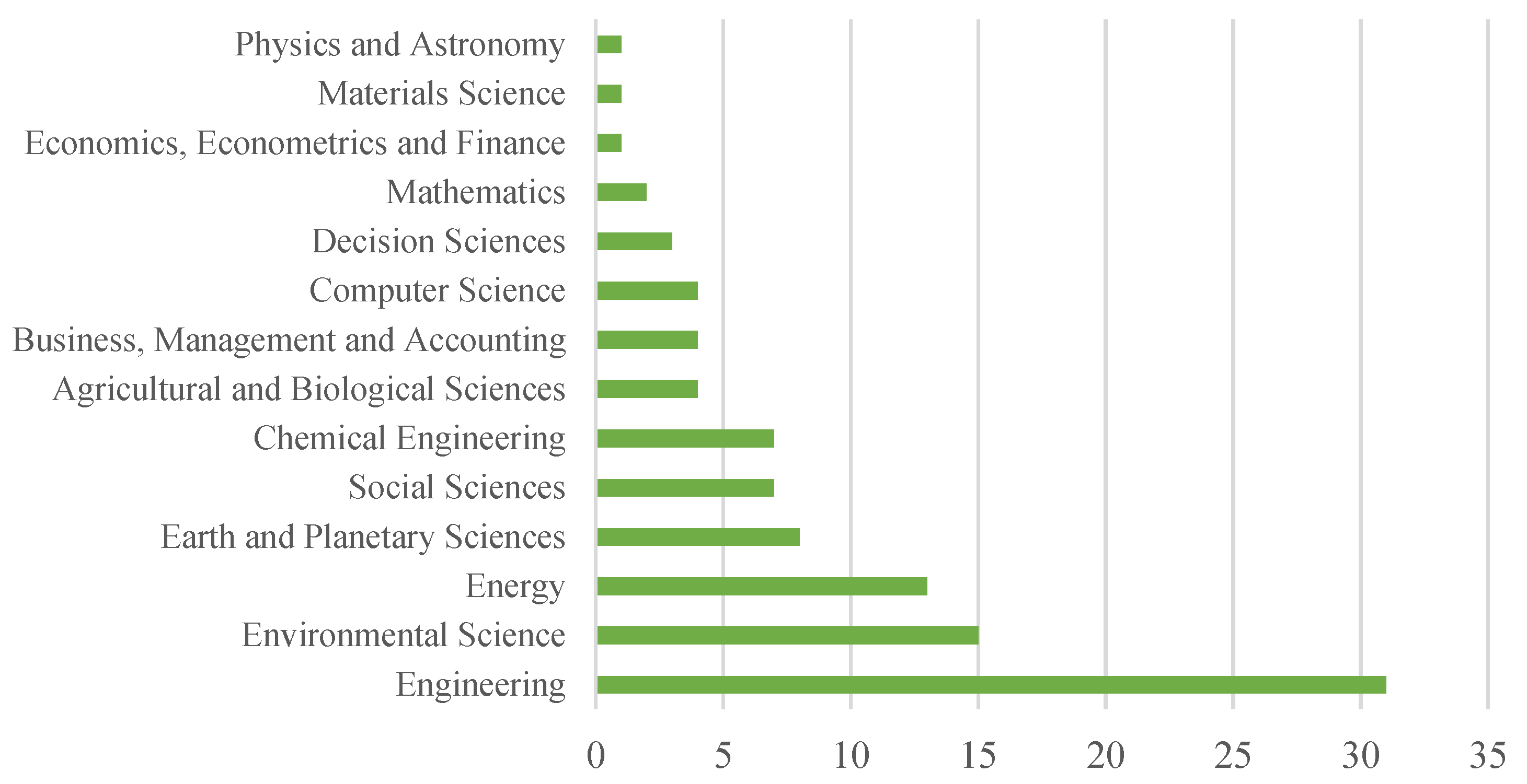
Figure 11 shows the area distributions of studies that are similar to the natural gas pipeline area and selected for the literature review. The main research area closely related to the natural gas pipeline issue is the field of “engineering”. After this field are the fields of “environmental sciences” and “energy”. The fields of “earth sciences”, “chemical engineering” and “social sciences” also emerged as related fields with selected articles.
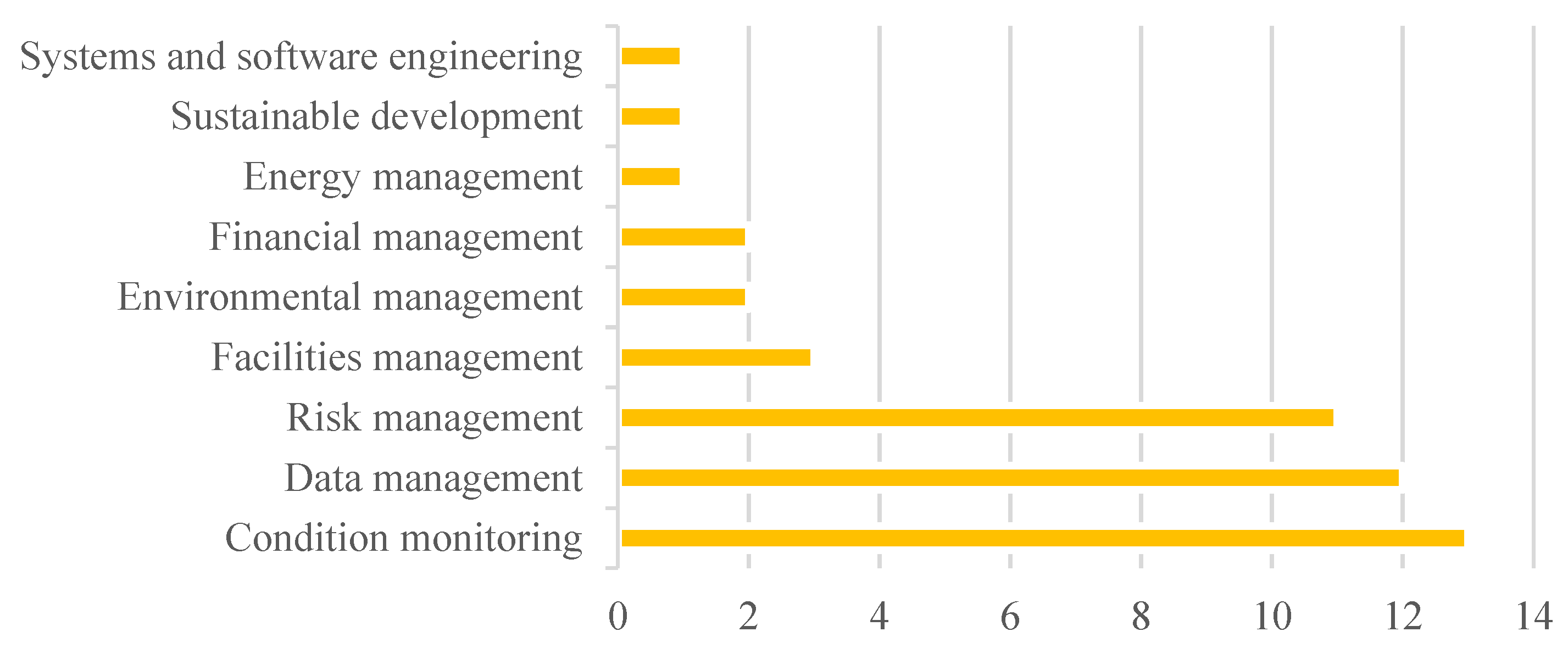
When these studies are classified according to asset management activities within the scope of the ISO 55000 Asset Management Standard (ISO, 2014), the graph shown in
Figure 12 emerges.
Looking at
Figure 12, it can be seen that most of the publications consist of condition monitoring, data management, and risk management contents, and in addition to these, there are studies in the fields of facility management, financial management, environmental management, energy management, sustainable development and systems and software engineering. Condition monitoring has taken its place in the literature as ensuring stability in the working conditions of physical assets, mainly in line with maintenance and operation management, and ensuring the continuity of their work without large expenses or renewal expenses. Data management is the healthy acquisition, storage, and use of all quantitative and qualitative information of physical assets. ISO [
36] defines this information as descriptive information, dimensions, capacity, performance, condition, age, remaining life, reliability, maintenance requirement, safety, environmental impact, legal and regulatory compliance, social and economic impact, cost, risk, and opportunity. On the other hand, according to the ISO 55000 Asset Management Standard, risk management of physical assets involves adopting a systematic approach to identify, evaluate, and control possible risks throughout the lifecycle of assets. This helps ensure that businesses operate uninterruptedly and efficiently by reducing the likelihood of assets malfunctioning or being damaged. The risk management process contributes to preserving the value of assets and achieving the financial goals of businesses.
The use of GIS with BIM for the management of linear engineering structures can enable standardized planning for integrating spatial data at different levels and ensuring sustainable development [
20]. This process involves the use of internationally accepted spatial data models and standards such as CityGML [
75] and IFC [
76].
When the publications were examined, it was seen that the majority of publications examined crude oil and natural gas pipelines. When looked at according to asset management activities within the scope of the Asset Management Standard [
36], condition monitoring activity and risk management activity are the majority. In publications on condition monitoring, the subjects of detecting corrosion and estimating maintenance intervals regarding monitoring the condition of subsea pipelines and offshore facilities have been studied [
77,
78,
79,
80,
81,
82]. Ensuring the use of information flow and decision support system concepts in pipeline integrity management within asset management is also among the issues examined [
83]. Risk management and decision-making problems in crude oil and natural gas pipelines are among the issues discussed together. Ensuring the safe operation of oil and natural gas facilities and pipelines of these facilities throughout their design lives has been examined by using risk assessment and decision-making techniques together [
84,
85,
86,
87]. Integrated risk assessment issues, which include technical, procedural, and behavioral elements, have been used in the literature in order to optimize safety in risk assessment practices in the oil and gas construction industry and to respond quickly and effectively to changes in the operating environment [
88,
89].
When looking at the publications related to crude oil and natural gas infrastructure and asset management activities within the scope of the Asset Management Standard [
36], it is seen that data management, facility management, environmental management, and financial management issues are also included in the relevant literature. Creating asset records and creating a standardized data structure to ensure effective asset management is vital in the decision-making process [
90,
91]. Effective data management strategies need to be developed in order to ensure efficiency, communication, and information exchange during the installation and operation phases of the facilities. In order to optimize business strategies in industries based on physical assets, standardization methodologies in data management need to be implemented [
92,
93]. This includes exploration, drilling, production, transportation, logistics, etc. in the oil and natural gas industry. Because of the necessity of monitoring such activities, asset management must also be ensured in these aspects. Aging assets create economic and operational risks in facility management. In order to manage these risks and ensure facility management in a holistic manner, decision support mechanisms should be created using technologies such as artificial intelligence, the Internet of Things (IoT), and GIS [
94,
95,
96].
The structural complexity and financial constraints of the assets used in the oil and natural gas sector make it difficult to make operations and maintenance decisions in a way that considers technical and environmental requirements [
97]. In order to ensure environmental sustainability in exploration, production, operation, and maintenance operations, it is necessary to attach importance to institutional innovation and develop government policies to reduce carbon emissions [
98,
99].
Another prominent topic within the framework of asset management is water infrastructure. Water transmission and distribution lines, wastewater lines, and rainwater lines are among the subjects examined under this title. A lot of data is needed for effective decision-making in water utilities. Methods such as stakeholder interviews, researching potential data sources, and defining information technology systems can be effective in establishing the data framework [
100]. It may be beneficial to detect faults, corrosion, and corrosion predictions in pipelines using pipeline monitoring methods. In particular, the transition to smart systems such as the Internet of Things (IoT), big data, system of systems (SoS), and the use of data management models can play an effective role in providing these benefits [
101,
102,
103]. There is a need to establish decision support systems within organizations in order to reduce the frequency of failures and reduce the lifecycle costs of pipelines. Data management is a critical stage for key tasks such as identifying risks and investigating the causes of failure in order to make informed asset management decisions [
104,
105,
106]. Businesses are obliged to perform their duties such as inspection and maintenance efficiently. Avoiding wasting resources, integrated planning, especially in maintenance tasks, and digitalization initiatives in infrastructure management can be beneficial [
107].
Wastewater and sewer lines are critical infrastructures that must be constantly monitored because of their potential to cause harmful effects such as pathogen spread, contamination of ground and surface water, damage to critical buildings and roads, and disruption of other vital services. In order to carry out activities that will prevent these risks on time and reduce maintenance costs, accurate data must be collected in order to maintain fault detection and maintenance practices effectively. Using these data, decision support systems can be developed with various data analysis methods such as machine learning, fuzzy logic, and regression [
108,
109,
110,
111].
Pipelines located underground are prone to failures due to corrosion. This can cause economic losses and social disruptions. Multiple potential failure modes, spatial variation in corrosion, and changes in pipe condition/strength over time can be modeled by random field theory [
112]. Carrying out inspection and maintenance activities at fixed intervals may cause the detection of some malfunctions to be postponed. The Probable Failure (PoF) threshold and the use of random field theory to model degradation factors in infrastructure can be used to model when pipelines need maintenance [
113]. The detection of underground pipelines using classical methods is an important challenge in maintenance, repair, and risk assessment activities. Methods based on augmented reality technology may be useful for accurate on-site detection and mapping of underground pipe networks and their conditions, dynamic construction, maintenance, and emergency response [
114].
Today, climate change is exacerbating extreme weather events, including floods. This situation poses a great risk, especially for roads, pipelines, and infrastructure systems. Data-driven focused flood modeling, produced by considering various factors such as the topographic index, rainfall intensity, culverts, and floodplains, helps identify high-risk flood areas and prioritize interventions [
115,
116]. Providing data-driven solutions faces various challenges such as information asymmetry. By considering the asset management system as a network, methods such as Network Centrality Analysis and KPI-Based Predictive Analysis can be used together with machine learning techniques to minimize systemic risks and provide a decision support system for asset management strategies [
117].
Countries face difficult choices among energy security, equity, and environmental sustainability. While investments in infrastructure and energy use help growth, they also negatively affect environmental concerns. Developing policies that simultaneously seek to increase economic growth and reduce environmental impact can contribute to sustainable energy consumption [
118]. The complexities and risks in carbon and energy prices present important implications for asset management. Investors should develop strategies to protect their portfolios against these risks and take advantage of opportunities. To manage the volatility and asymmetric risks of carbon and energy prices, asset managers can incorporate developments in the carbon and energy markets into their portfolio management strategies and reduce these risks by using asset allocation and risk management techniques. Investors can both reduce their risks and gain financial returns by investing in low-carbon and climate-resilient assets, considering the long-term impact of trends such as the transition to renewable energy on carbon and energy markets [
119].
Standardized formats for data needs and data sharing in the energy sector can expand the scope of interoperability. Asset management systems face challenges because of information asymmetry and redundant information dumps. For network-based asset management organizations, asset management is an important business management resource. Compliance with the ISO 55000 Asset Management Standard is a significant challenge for organizations with network-based assets. To analyze these challenges and increase the resilience of asset management systems, integrated data management and standardization approaches may be useful [
120,
121,
122].
6. Discussion
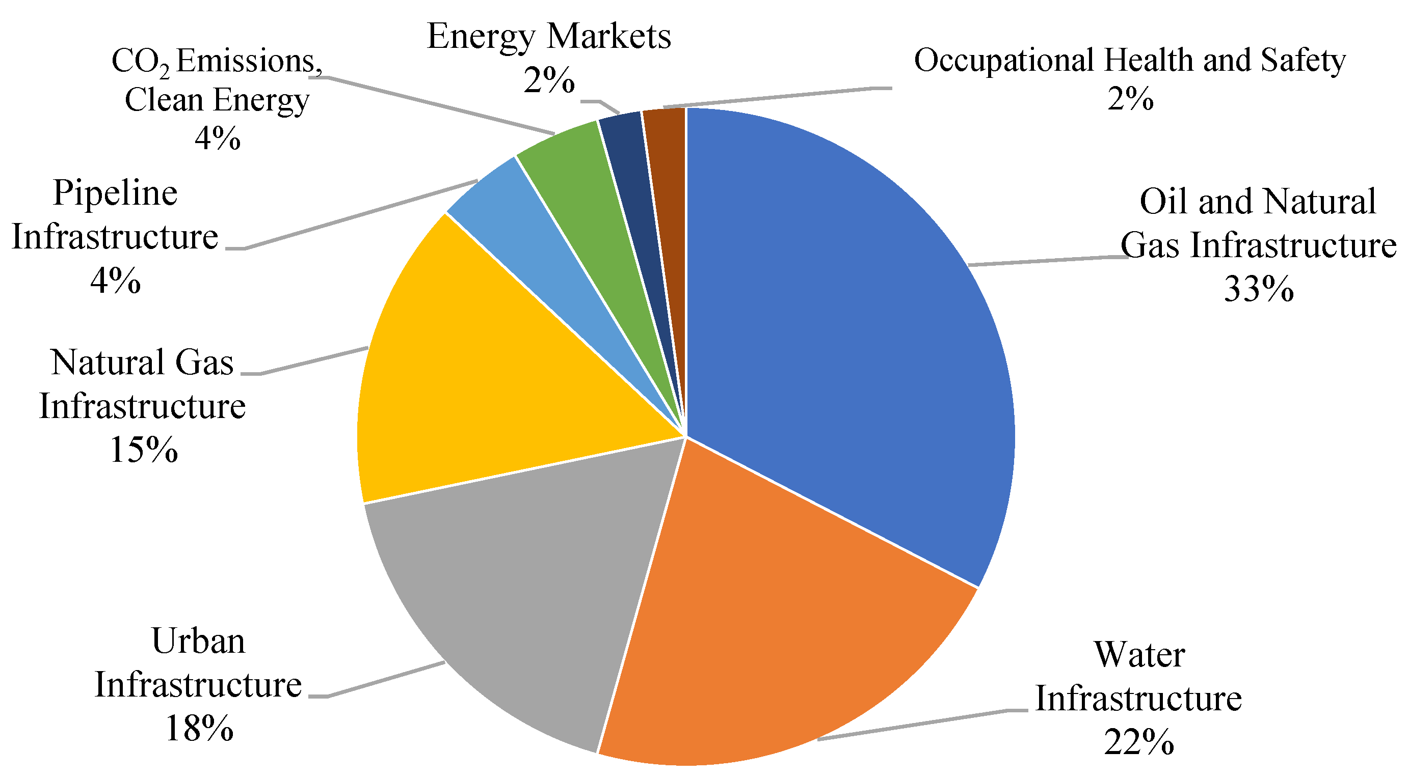
In this article, the scope of the literature on infrastructure and pipelines was examined with an asset management approach, and publications on natural gas pipeline infrastructure and similar physical assets were evaluated in detail. Bibliometric analyses have revealed that, from an asset management perspective, there is a research gap in infrastructure and natural gas pipeline infrastructure. In the extensive literature research conducted during the systematic literature review, asset management applications were mostly discussed in condition monitoring, data management, and risk management. Looking at
Figure 13, within these subject headings, it can be seen that publications are mainly produced evaluating oil and natural gas infrastructure, water infrastructure, urban infrastructure, and natural gas infrastructure.
In the content of the publications, it was seen that studies were generally carried out on risk management and decision support mechanisms for condition monitoring and maintenance planning related to risk management. Since physical assets, by their nature, wear out over time, monitoring these assets is a critical process in order to reduce business risks and prevent accidents. In studies dealing with risk management and condition monitoring, topics such as corrosion detection methods, optimization of maintenance plans, and development of decision support mechanisms for physical asset management have been examined. In the publications examining the topics of environmental management, energy management, financial management, and sustainable development, the development of decision-making mechanisms, environmental sustainability, efficiency, and energy policies were examined.
In the publications handled with the asset management approach, there were studies that proposed a standardized framework for the creation of asset records based on ISO 55000 Asset Management, effective use of information technologies, and integrated data management for the purpose of interoperability in the energy sector [
90,
100,
107,
122]. However, considering natural gas pipeline asset management as a whole, there is a research gap in the field evaluating infrastructure management, data integration, and data standardization.
Considering the literature review and analysis, several key insights and further implications emerge that warrant attention. Firstly, the focus on risk management and decision support mechanisms in relation to condition monitoring and maintenance planning is crucial for enhancing operational safety and efficiency in the energy sector, particularly in the context of natural gas pipelines [
83,
84,
85,
86,
87]. The importance of addressing wear and tear through rigorous condition monitoring underscores the necessity of continual improvement in corrosion detection and maintenance optimization methods [
77,
78,
79,
80,
81,
82,
88,
89].
Moreover, the exploration of decision support mechanisms for physical asset management suggests a growing acknowledgment of the need for sophisticated tools that can handle complex data and assist in making informed decisions [
90,
91,
92,
93,
94,
95,
96]. This is particularly relevant given the advancement of technologies that can potentially transform traditional asset management practices [
100,
101,
102,
103].
Under The Paris Agreement, initiatives are being adopted to reduce greenhouse gas emissions and to decrease the use of fossil fuels in energy production, with shifting supply dynamics indicating that hydrogen is expected to play a critical role in the future. Hydrogen not only acts as a means for decarbonization but also serves as a storage and transfer medium for renewable energy during periods of excess supply [
122]. There is growing interest in repurposing existing natural gas pipelines to transport hydrogen, which is a clean-burning fuel with the potential to decarbonize various sectors. As a more environmentally friendly energy alternative, the integration of hydrogen with natural gas significantly contributes to the transportation of large quantities of energy over long distances at lower costs [
123]. The proposed model can also be used to understand how suitable the existing infrastructure is for this transformation and to make improvements such as capacity estimation.
The integration of ISO 55000 standards into asset management highlights a systematic approach to maintaining asset integrity and reliability. It suggests a move towards standardization and structured methodologies in asset management, which can lead to improved interoperability and efficiency across the sector. However, the research gap identified in the comprehensive management of natural gas pipeline assets, particularly in the areas of infrastructure management, data integration, and standardization, points to a critical need for further study. This gap indicates potential areas where future research could significantly contribute to the development of more resilient and efficient asset management frameworks.
It should be taken into consideration that this research gap has both advantages and difficulties. Integrating BIM and GIS holds significant potential for enhancing construction, infrastructure development, and urban planning. Despite their individual strengths, the integration of these technologies confronts multiple challenges. Firstly, data incompatibility issues arise because of differing file formats—such as IFC for BIM and Shapefiles or GeoJSON for GIS—along with distinct data structures and levels of detail (LoD). BIM’s focus on detailed building components contrasts with GIS’s emphasis on spatial relationships and broader geographic contexts, complicating the matching of varying precision levels. Additionally, semantic differences exacerbate integration difficulties; terminology discrepancies and the complexity of semantic mapping between the rich attributes of BIM models and GIS’s spatial representations often result in misinterpretations or loss of information meaning. Technical challenges further hinder integration, including limited software interoperability, incompatible coordinate systems, and the high computational demands of managing large, complex datasets, which can affect performance and scalability. Organizational and process-related challenges also emerge, particularly in fostering effective collaboration and communication among diverse teams and stakeholders, and in managing data ownership and long-term data handling.
Addressing these substantial challenges necessitates a range of solutions and strategies. The adoption of open standards and data formats, such as IFC for BIM and CityGML for GIS, is crucial for facilitating better data exchange. Efforts to develop methods for semantic enrichment are essential to ensure the preservation of meaning between BIM and GIS models. The emergence of hybrid software solutions and plugins also plays a pivotal role in bridging the divide among these systems, thereby enhancing interoperability. Moreover, establishing well-defined workflows and collaborative processes across BIM and GIS teams is fundamental to the success of integration projects. These strategies collectively aim to mitigate the complexities involved in merging BIM and GIS, thereby unlocking their combined potential to revolutionize the fields of construction and urban planning.
Thus, addressing these gaps not only strengthens asset management practices but also aligns with broader goals such as environmental sustainability, energy efficiency, and financial management within the framework of sustainable development. Consequently, there is a compelling case for enhancing research efforts in these areas to better support the evolving needs of the energy sector.
7. Conclusions
Considering the presented review of the current literature and all the examinations, the data obtained about physical assets, the sufficient resolution of the data, and the accuracy of the data are of critical importance. Pipeline infrastructures often have wide spatial distribution and include various pipeline types and assets such as stations. Efficient results can only be achieved in matters such as risk management, condition monitoring, facility management, and environmental management when spatial details are considered. Sustainable design, construction, and operation of pipelines and associated facilities can benefit if data on physical assets are systematically captured and adhere to specific standards and procedures.
Industry standards from various organizations (ISO, API, ASME, etc.) are used during pipeline infrastructure design, construction, and operation. These standards are vital for the configuration and design of pipeline infrastructure and associated facilities and for public safety purposes. In order to ensure the safe and efficient operation of the pipeline infrastructure, data must be obtained systematically. The data infrastructure to be developed in accordance with asset management principles can provide safe and efficient design, construction, and operation conditions.
Nationally and internationally accepted standards developed by various organizations (ISO/TC211, OGC CityGML, etc.) are used for the production, use, storage, and sharing of geographical data. Geographic information is closely related to spatial information and all other features of objects. Therefore, the locations and all other intangible and concrete features of physical assets should be taken into consideration within the scope of asset management. In this regard, sustainable natural gas pipeline infrastructure management can be achieved by using asset management standards, industry standards, and spatial data infrastructure standards together.
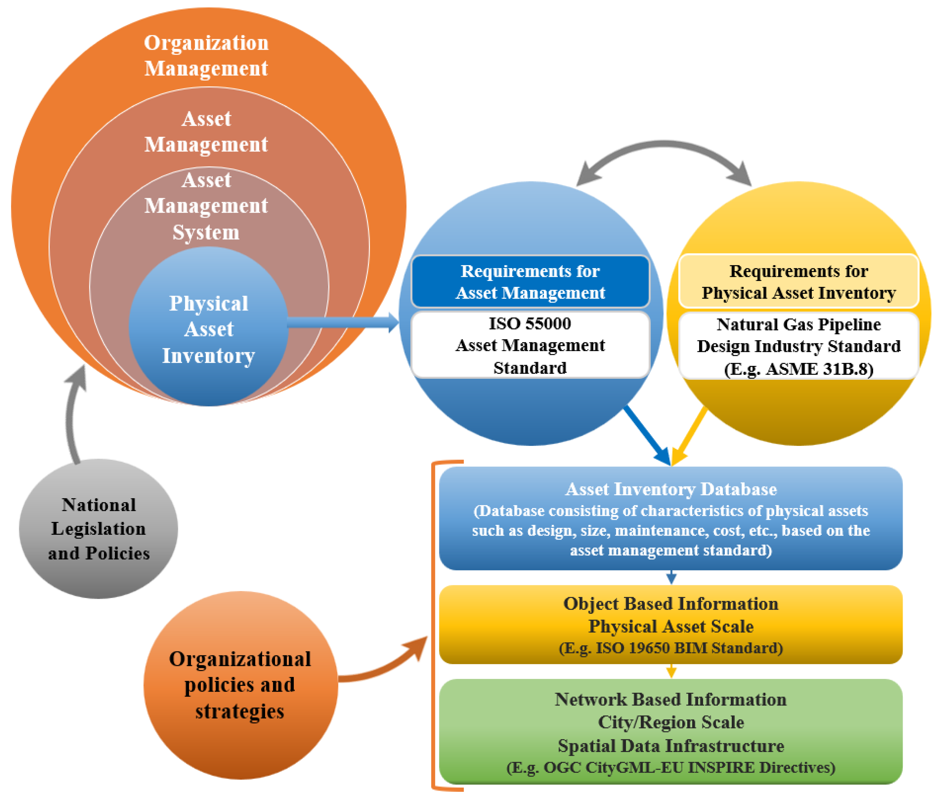
The optimum asset management system is possible with an information inventory prepared according to the principles of asset management standards and containing the properties of assets as objects. Natural gas pipelines have a geographically wide distribution and a complex structure, including ownership and land management issues. The model in
Figure 14 is proposed to manage this complex structure.
There are a number of national legislations and policies in the natural gas pipeline sector. The production or import, transmission, and distribution of natural gas from domestic resources depends on various legislations and procedures. An asset management system to be prepared in this direction should be dependent on these legislations and policies.
The reliability and accuracy of the data used in the asset management system are directly dependent on their production in accordance with certain standards and procedures. Data generation is often an expensive and time-consuming process. For pipeline investments, which require a lot of financial resources not only for investment but also for operation, less importance is given to data collection and storage compared with other activities. However, the planning, design, construction, and operation of a pipeline are directly data-dependent activities. Therefore, organizations should give importance to asset inventory within their asset management systems. The data to be used within the natural gas pipeline asset management system should also be produced in accordance with the design documents that are the source of the natural gas pipeline infrastructure. There are various industry standards published for the production, transmission, and distribution of natural gas pipeline infrastructure that are widely used in the world. All components used in these infrastructures are treated as physical assets within the asset management system. All characteristics of these physical assets are included in the asset inventory as “information” during the creation of asset records. In this sense, the BIM process is an ideal method for creating asset records. When asset management is considered as a network, GIS and the spatial data infrastructure standards used in creating this system come into play for the spatial data infrastructure to be created.
BIM and GIS alone cannot fully support project management and decision-making processes. Therefore, both must work together for effective integration. The literature review showed that there is a research gap for BIM-GIS integration in natural gas pipeline asset management. Although the evaluations present BIM-GIS integration in asset management for natural gas pipeline infrastructure as an ideal asset management framework, various technical difficulties are likely to arise in this integration. There is a need to ensure harmonization among asset management standards, industry standards, and spatial data infrastructure standards.
BIM-GIS integration in natural gas pipeline infrastructure asset management can offer several opportunities. In particular, combining the potential of BIM and GIS can improve the strategic and operational aspects of the organization. The detailed information and geometric modeling capabilities of BIM and the advanced data integration and management potential of GIS can be useful in asset management problems where multi-scale and interdisciplinary problems arise, such as risk management and maintenance operations management. Thanks to the detailed data on the assets in the asset management system, it can contribute to condition monitoring, facility management, and lifecycle cost monitoring activities. With this integrated approach, cost-effective asset management of existing assets and immovable properties can be achieved and managed holistically in accordance with contemporary land management requirements, and infrastructure can be provided for the organization’s investments.
The proposed integrated approach for natural gas pipeline infrastructure asset management can provide an advantage to improve spatial information management using data analysis and visualization, employ new technologies in traditional infrastructure engineering fields, design more efficient lifecycle activities, and facilitate sustainable land management. The proposed integrated approach is in close relationship with some current technologies.
Various methods and applications can be developed in future studies by establishing a relationship with this approach. Thanks to the evaluation of asset records in the BIM process, digital twins, augmented reality, and smart city applications can be implemented. Effective CAPEX and OPEX investments are crucial for maintaining a reliable pipeline network. The proposed approach with its focus on data analysis, new technologies, and efficient lifecycle activities can significantly improve how these investments are managed, ultimately contributing to a more sustainable and cost-effective natural gas pipeline infrastructure. Effective asset management can incorporate condition monitoring, investment and operating cost tracking, and the topic of repurposing existing natural gas pipelines to transport hydrogen, which has been an attractive topic in natural gas pipelines in recent years. With the proposed model, positive developments can be achieved, and benefits can be obtained in the digital transformation of natural gas pipeline infrastructure.
This study provides a detailed approach to enhancing asset management for natural gas pipeline infrastructure by integrating BIM and GIS. Key solutions include utilizing BIM to create comprehensive asset records that align with design documents and are produced according to industry standards. Concurrently, GIS should be developed to manage and analyze the extensive geographical data of pipeline assets, ensuring data are managed effectively and supporting decision-making processes. Harmonization of the asset management system with national and industry standards alongside spatial data infrastructure standards is crucial for maintaining consistency and compliance. The integration of BIM and GIS can be leveraged to address challenges such as risk management and maintenance operations by utilizing their detailed modeling and data integration capabilities. Additionally, exploring new technologies such as digital twins, augmented reality, and smart city applications within this framework can enhance monitoring and management capabilities. Implementing an integrated approach can also facilitate more efficient lifecycle activities and sustainable land management practices, employing data analysis and visualization to optimize capital and operational expenditures. Supporting digital transformation within the organization can facilitate the repurposing of existing infrastructure, such as adapting gas pipelines for hydrogen transport, thereby enhancing sustainability and cost-effectiveness. Finally, establishing well-defined workflows and fostering collaboration across teams ensures effective implementation and utilization of integrated BIM and GIS technologies in various stages of asset management. By applying these solutions systematically, organizations can achieve significant improvements in operational efficiency, cost reduction, and regulatory compliance in natural gas pipeline asset management.

