Abstract
The largest carbonate condensate field in China has been found in the central Tarim Basin. Ordovician carbonate reservoirs are generally attributed to reef-shoal microfacies along a platform margin. However, recent production success has been achieved along the NE-trending strike-slip fault zones that intersect at the platform margin. For this contribution, we analyzed the strike-slip fault effects on the reef-shoal reservoirs by using new geological, geophysical, and production data. Seismic data shows that some NE-trending strike-slip faults intersected the NW-trending platform margin in multiple segments. The research indicated that the development of strike-slip faults has affected prepositional landforms and the subsequent segmentation of varied microfacies along the platform margin. In addition, the strike-slip fault compartmentalized the reef-shoal reservoirs into multiple segments along the extent of the platform margin. We show that fractured reef-shoal complexes are favorable for the development of dissolution porosity along strike-slip fault damage zones. In the tight matrix reservoirs (porosity < 6%, permeability < 0.5 mD), the porosity and permeability could be increased by more than 2–5 times and to 1–2 orders of magnitude in the fault damage zone, respectively. This suggests that high production wells are correlated with “sweet spots” of fractured reservoirs along the strike-slip fault damage zones, and that the fractured reservoirs in the proximity of strike-slip fault activity might be a major target for commercial exploitation of the deep Ordovician tight carbonates.
1. Introduction
Carbonate is a prolific hydrocarbon reservoir found globally [1,2,3]. With the production decline of shallow oil/gas resources, deep (>4500 m) pre-Mesozoic carbonate reservoirs have become an important exploitation frontier [3,4]. This is in contrast to the porosity and permeability of carbonate reservoirs, which decrease with depth during burial [5]. In deep, tight carbonates, fracture activity plays an important role in enhancing permeability and porosity along fault damage zones [6,7,8]. Furthermore, pre- and syn-sedimentary fault activity could lead to segmentation and diversity of the carbonate sedimentary facies [9,10,11], and subsequently lead to varied reservoirs [12,13]. Generally, fractured reservoirs are described by seismic methods in the deep subsurface [14,15]. However, methods for imaging deep reservoirs are limited, making the identification of localized fractured reservoirs challenging. Therefore, the method of incorporating geological and geophysical technologies has been widely used in the description of deep fractured reservoirs [14,15,16,17].
In the Tarim Basin (Northwest China), substantial hydrocarbon reserves have been found in deep Ordovician limestone [14,18]. The reef-shoal reservoirs of the Upper Ordovician developed along the platform margin in the central Tarim Basin [18,19,20,21,22]. Despite some success in the exploration of these reef-shoal reservoirs, low production from low poro-perm (<6%; <1 mD) rocks has often inhibited commercial exploitation of these deep reservoirs. As most reef-shoal reservoirs cannot be exploited economically by conventional technologies, they are commonly indicated to be unconventional tight reservoirs [13,23,24]. Horizontal well drilling and large acid fracturing technologies have been carried out to enhance production [13]. Although production can be enhanced (1–2 orders of magnitude), there are still many low production wells targeting these reef-shoal reservoirs [13].
Recent studies have suggested that most high production wells were correlated to highly fractured and karstified carbonate reservoirs known as “fracture-cave reservoirs” in a thrust fault zone along the eastern platform margin [12,13]. Fracture (joint) activities have a significant effect on the permeability and porosity of fracture-cave reservoirs [25,26,27,28,29]. The porosity of fracture-cave reservoirs is generally attributed to the presence of penecontemporaneous dissolution and/or transitional karstification [19,22,30]. It has also been shown that thrust faults enhance karstification and lead to the creation of large karstic caves with high production characteristics [12,28]. Furthermore, fracture-cave reservoirs are known to have developed at the top of the Lower-Middle Ordovician unconformity along strike-slip fault zones [28,31,32]. In this context, the Ordovician reef-shoal reservoir might have complex poro-perm characteristics, meaning that the strike-slip fault effects on the reef-shoal reservoirs in the Upper Ordovician require reevaluation.
In this study, we assess Ordovician carbonate reservoirs by differentiating tight matrix and fractured reservoirs using static and dynamic reservoir data. We elucidate the characteristics of fractured reservoirs along the strike-slip fault damage zones. Finally, we discuss the fault effects on reef-shoal reservoirs and the challenges regarding reservoir exploitation in the deep subsurface.
2. Geological Setting
The Tarim Basin covers an area of 56 × 104 km2 in NW China (Figure 1a). This intracratonic basin has undergone multiple tectonic phases and is infilled with 15,000 m thick Cryogenian–Quaternary strata [28]. A large carbonate platform formed in the western basin during the Cambrian–Ordovician period, covering an area of 24 × 104 km2 with a thickness of 3000 m [28]. From the end of the middle Ordovician, the Central (Tazhong) Uplift was initiated during the closure of the Proto-Tethys Ocean [28,33] (Figure 1c). Multiple unconformities and faults were reactivated from the late Ordovician to the middle Devonian period. Since the late Devonian era, the Central Uplift has had episodic subsidence in its peripheral areas [28].
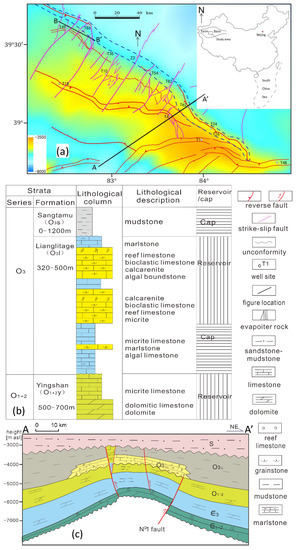
Figure 1.
A tectonic sketch of the Ordovician carbonate top (a), the Middle-Upper Ordovician strata column (b) and the reservoir model of the Upper Ordovician (c) in the Central Uplift (revised after References [13,28]).
The reef-shoal reservoirs in the Upper Ordovician and the karstic reservoirs at the top of the Middle Ordovician unconformity are major oil/gas exploitation targets in the Central Uplift [13]. The largest condensate field in China has been found along the northern platform margin. An isolated carbonate platform of the Upper Ordovician Lianglitage Formation has overlain in an unconformable contact on the Middle Ordovician Yingshan Formation (Figure 1b,c). The Lianglitage Formation is composed of 300–600 m thick limestones with burial depths of 4500–7500 m. Multicyclic reef-shoal complexes developed along the northern rimmed platform margin with a length of 220 km, extending over an area of 1200 km2 [13,19,20,21,22,28]. Three major stages of oil/gas accumulation occurred in the late Ordovician-Silurian, Permian, and Cenozoic periods [28]. This led to resource enrichment along the northern marginal reef-shoal reservoirs and unconformity in the northern slope of the Central Uplift [28]. During the middle-late Ordovician period, NW-trending reverse faults and subsequent NE-trending strike-slip faults occurred across the Central Uplift [28]. It has shown that thrust fault activities along the platform margin control fractured reservoirs in the Upper Ordovician reef-shoal complex, and the strike-slip faults affect the Middle Ordovician karstified reservoirs [13,25,26,27,28,29,30,31,32]. However, few studies have shown the strike-slip fault effects on the reef-shoal reservoirs.
3. Data and Methods
Static and dynamic data of more than 40 wells in the Upper Ordovician carbonates were collected. Cores and thin sections were used to describe the fractured reservoirs and matrix reservoirs (after references [12,13]). Furthermore, FMI (Formation MicroScanner Image) data are helpful for the description of the fractured reservoirs. The statistical fracture characteristics (fracture frequency, occurrence, and opening) were defined from core measurement and FMI data. The porosity-permeability values were determined by core plug measurement and logging processing (after references [12,13]).
Finally, 12,000 km2 of 3D seismic data were obtained on the northern slope of the Central Uplift. Pre-stack time and depth migration datasets were used for fault mapping and the identification of large fracture-cave reservoirs [14,34,35]. Enhanced coherent and maximum-likelihood attributes were used to map the small fault [14]. Seismic amplitude and structure tensor attributes were used to describe the large fracture-cave reservoir [13,14].
4. Results
4.1. The Faults in the Reef-Shoal Complex
Through the 3D seismic interpretation, sixteen large strike-slip faults were identified from the seismic data, with lengths of 20–50 km (Figure 2). The major faults FI5, FI17 and FI21 are in excess of 200 km long. Horizontal displacements along the strike-slip faults are less than 600 m at the Ordovician level. In the seismic section, the strike-slip faults show simple vertical fault planes and positive- and negative-flower structures (Figure 3). Vertical throws are generally in the 30–150 m range, but can be seen to be up to 400 m in the cases of the trans-tensional grabens. Transpressional faults formed in the Cambrian-Ordovician carbonates show a positive-flower structure, but trans-tensional structure in the overlying strata. Most strike-slip fault zones spread upward into the Devonian, only a few fault zones extending into the Permian. The inherited strike-slip faults in the Silurian-Permian are short trans-tensional in echelon faults, with vertical displacements of 200 m at the Silurian level, and of less than 100 m at the Carboniferous-Permian level.
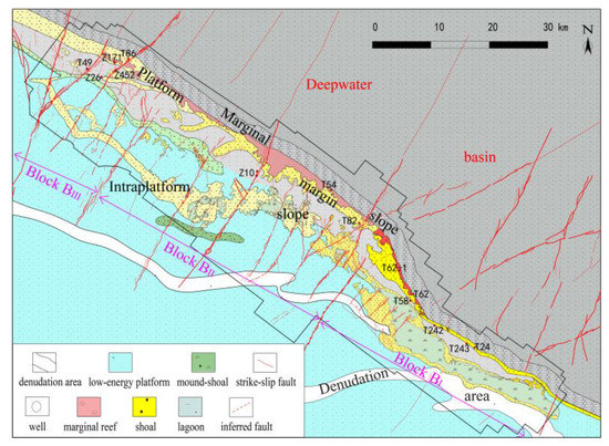
Figure 2.
The microfacies of the Lianglitage Formation overlapping with strike-slip fault system in the northern Central Uplift (The microfacies data are from references of [19,22,28], the thrust faults are modified after reference [28], the strike-slip faults are from recent seismic interpretation data).
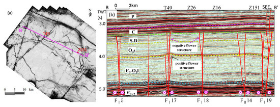
The short faults (~4 km) form mostly isolated segments. With fault growing and overlapping, there are more incidences of fault linkage and interaction. There are secondary faults and complicated deformation in the overlap zones, although it is difficult to map small secondary faults using seismic data. The unmatured strike-slip fault zones show distinct segmentation in en echelon and soft linked segments, but no distinct segmentation boundary in hard-linked fault zones. The strike-slip faults are composed of multiple segments in different fault patterns. Generally, the strike-slip fault zones have several segments, including a linear segment with small displacement and weak linkage, an overlapping segment with hard-linkage and interaction, resulting in strong deformation, and a horsetail/linear segment at the fault tip from south to north.
In the eastern and western platform margin (Figure 2), a NE-thrusting fault belt separated the platform and the northern depression. Generally, the strata are relatively continuous in the depression, but are absent from the Yijianfang and Tumuxiuke formations on the hanging wall along the paleouplift edge. The faults generally expand upward and terminate in the Upper Ordovician Sangtamu Formation in the western margin, but at the base of the Upper Devonian in the eastern area.
In the platform margin, the seismic data suggested that NE-trending strike-slip faults cut across the reef-shoal complex of the Upper Ordovician (Figure 2 and Figure 4). Faults FI19 and FI21 separate the northern slope, showing a series of blocks from west to east. Strike-slip faults developed in the western blocks BIII and BII areas, but decreased in the eastern block BI. Conversely, intense thrust faulting activity occurred in eastern block BI.
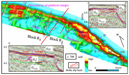
Figure 4.
The palaeogeomorphic map of the reef–shoal complex of Lianglitage Formation along the northern platform margin (modified after reference [13,14]). The map and seismic profiles showing the reef–shoal segmentation and variation by the strike-slip faults (O1+2y: Yingshan Formation; O3l: Lianglitage Formation; O3s: Sangtamu Formation; TWT: two-way traveltime).
Separated by the strike-slip faults FI21 and FI19, the reef-shoal complex is divided into three segments along the platform margin (Figure 2). In the eastern segment, a rimmed platform margin has developed along the thrust fault belt [12,19]. A relatively narrow (<2 km width) but thicker (more than 500 m) group of shoal bodies has formed in the eastern T24 block, and has progressively turned into wide high-energic reef-shoal bodies in the western T62 block (Figure 4). The two blocks are separated by a small NE-trending strike-slip fault zone. It may be noted that there are signs of intense thrust fault activities rather than a weaker strike-slip faulting after the carbonate deposition (Figure 4). In the central segment, it became a weak rimmed or non-rimmed platform margin. The broad high-energic facies is mainly composed of shoal bodies, but shows a lack of reefs. The central segment is also divided into two areas by FI21. The eastern part is wider with higher energic shoal bodies than the western area. In the western segment, there are progressively wider but lower energic shoals along the platform margin. Additionally, more strike-slip faults have intersected the platform margin of the Upper Ordovician.
4.2. Matrix Carbonate Reservoirs
The Ordovician reefs include porifera, stromatoporoid and coral framestones [19,20,21,22]. The porosity in these relatively small reefs is generally filled with lime-mud and fine bioclastic (Figure 5a). Furthermore, the framework porosity has been almost lost due to cementation. Sparse dissolution porosity developed along the framework pores, and some intragranular dissolution pores were observed in the reef fragments in the eastern segment (Figure 5c). Generally, the connectivity of the intragranular porosity is too weak to allow the development of favorable dissolution reservoirs. In contrast, we found that further intergranular dissolution porosity developed along the bioclastic and calcarenite around the reefs (Figure 5b,d). The intergranular dissolution vug (diameter between 2–100 mm) and pore (diameter < 2 mm) occur mainly in grain stones. It has developed well in the reef-shoal limestones along the platform margin, particularly in the eastern segment. Although most of the primary porosity has been lost by intense cementation during the long burial history, most dissolution porosity seems to have occurred alongside the primary porosity in these reservoirs. Dissolution pore-vugs in cores are generally paralleled along strata bedding with layers tens of cm thick (Figure 5b). The multiple dissolution intervals can be composed of layers several meters thick in the reservoir that is the major drilling target in the matrix reservoir along the reef-shoal complex. It was shown that the high-porosity reservoirs generally occurred along the eastern thrust fault belt and the strike-slip fault zones.
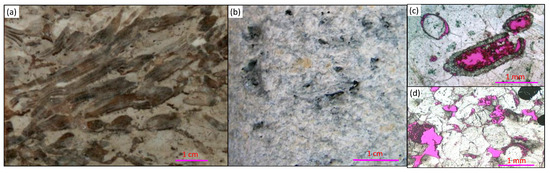
Figure 5.
Photographs of the carbonate matrix reservoirs. (a) stromatoporoid reef limestone, T243, 4473.93 m, core; (b) dissolution vugs in the bioclastic limestone, T62, 4755.5 m, core; (c) intragranular dissolution pores in bryozoa fragment, T54, 5757.83 m, casting thin section; (d) intergranular dissolution pores in bioclastic rock, T62, 4751.2 m, casting thin section (pink-dye resin showing porosity).
An analysis of core plugs indicated that matrix porosity (0.1–10.1%) is generally lower than 5%, with most of the samples showing a permeability lower than 0.2 mD (Figure 6a). Log data indicate that the reservoir porosity ranged from 2% to 6%, and permeability generally varied from 0.4 mD to 4 mD in the matrix reservoirs (Figure 6b). It is noteworthy that there are generally micro-throats (most radius <0.1 μm) in the matrix reservoirs. Except for those in fractured zones, matrix reef-shoal reservoirs have very low porosity-permeability, which makes them tight reservoirs along the platform margin.
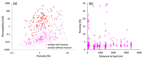
Figure 6.
Porosity-permeability correlation from the core plugs (a) and average porosity of a well reservoir interval vs. distance to fault (b) by logging interpretation in the Ordovician reef-shoal reservoirs.
Generally, conventional production from these tight reservoirs is not economical. Horizontal drilling and acid-fracturing technologies have been utilized in reef-shoal reservoirs, and although this has increased gas production, low production has been observed for a number of wells targeting these deep and tight reservoirs. Even in better matrix reservoirs, there is generally low oil/gas production (Figure 7a) that cannot be economically exploited in the deep subsurface.
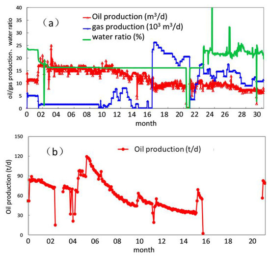
Figure 7.
The typical production curves of the matrix reservoir (a) and fracture-cave reservoir in the oil production wells (b).
4.3. Fractured Reservoirs
Alongside the reef-shoal complex of the platform margin, fracture networks developed along fault damage zones (Figure 8). Generally, fractures have high angles and narrow apertures (Figure 8a). Multiple sets of fractures form a complex fracture network, especially in inner fault zones. Fracture frequency varied widely from 1 to 17 m in cores and FMI images. Few wells intersecting inner fault damage zone penetrated breccias. Although most fracture porosity has been filled with calcite cements and argillaceous material, many fractures are still opened and show porosity (Figure 8a–e). Dissolution porosity occurred along fractures, which led to increased fracture opening width (Figure 8b,d). Importantly, increased dissolution porosity and vugs developed along fractures (Figure 8a,e).
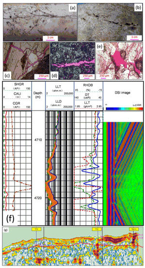
Figure 8.
Photographs of Ordovician carbonate reservoirs. (a) open vertical fractures and dissolution pore-vug, T242, 4501 m, core; (b) dissolution pores and vugs along fractures, T62−1, 4894.5 m, core; (c) open fracture network, T24, 4687.75 m, casting thin section; (d) dissolution pores along fractures, T82, 5375.5 m, casting thin section; (e) dissolved pores along fractures, T82, 5364.74 m, casting thin section; (f) logging image of a fracture-cave reservoir, T58 (after reference [13]; (g) The seismic spectral decomposition section of the fracture-cave reservoirs (The “bead-shape” reflection showing large fracture-cave reservoir, see reference [13]).
Recently, many more caves (diameter > 100 mm, large cave diameter > 1000 mm) have been found in these tight carbonate reservoirs along the fault zones [13]. According to the seismic data, connected caves and the fracture network form prolific fracture-cave reservoirs with strong “bead-shaped” reflections (Figure 8g). According to the log data, large fracture-cave reservoirs generally possess an enlarged borehole diameter, raised natural gamma, and reduced resistivity log responses (Figure 8f). Although cores are hardly ever obtained from large fracture-cave reservoirs, drilling breaks, mud loss, and overflow indicated that the wells encountered large fracture-cave reservoirs during the drilling period. For example, mud loss reached 799.2.5 m3 and two intervals of drilling break with thicknesses of 0.2 and 0.5 m in well T62-1 [13]. Through identification by seismic data, the fracture-cave reservoirs developed well along the strike-slip fault damage zones (Figure 9).
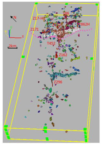
Figure 9.
3D visualization of the fractured reservoirs along the strike-slip fault FI17 in the northwestern area (the NW-trending bands showing the reef-shoal reservoirs, and the spots showing the fracture-cave reservoirs which are distributed along the NE-trending strike-slip fault zone).
In core plugs data (Figure 6a), samples with fractures generally show slightly higher porosity than the matrix reservoirs. The porosity of the fractured samples increases by 5% to 20%, whereas the permeability values (0.01–516 mD) of these samples could increase by 1–3 orders of magnitude more than the samples without fractures. It was noted that the high permeability of more than 1 mD is mainly derived from the fractured samples. According to the log data, fracture porosity is generally less than 0.5%. The porosity of the fracture reservoirs is generally consistent with the matrix reservoirs. However, the porosity of fracture-cave reservoirs along fault zones can increase from 5% to 30% if dissolution porosity occurs (Figure 6b). Furthermore, permeability can increase by more than 1–2 orders of magnitude in fractured reservoirs. In addition, most high production wells have targeted fracture-cave reservoirs along the fault zones. The statistics presented in the log data of the reservoir intervals show that large-scale fracture-cave reservoirs are generally distributed at a distance less than 1500 m from fault damage zones (Figure 6b) and have a porosity 2–5 times higher than the tight matrix carbonate reservoirs in the reef-shoal complex. Generally, fractured reservoirs can yield high production, particularly for large fracture-cave reservoirs (Figure 7b). Initial production in the fractured reservoirs can be ten times higher than in the matrix reservoirs. By contrast, many wells show irregular and suddenly declining production. Additionally, many fractured reservoirs were susceptible to fast water flooding during the production.
5. Discussion
5.1. Fault Effect on the Variation of the Reef-Shoal Bodies Distribution
It has been shown that the carbonate platform margin can be divided into three segments with the use of different thrust fault geometry and evolution [12]. In addition, the higher energic reef-shoal complex developed in the eastern intense thrust fault zone. It was seen by contrast, however, that the NW-trending platform had been intersected by the NE-trending strike-slip fault zones (Figure 2). These suggest that there are complicated relationships between the fault activity and the varied reef-shoal microfacies along the platform margin.
Recent studies suggest that the NE-trending strike-slip faults have been initiated contemporaneously with the NW-trending thrust faults [28,36]. During the uplifting of the Central Uplift in the end of the middle Ordovician period, the strike-slip faults accommodated the NE-SW contraction and subsequently divided the platform margin into a serial of blocks along its strike. In this way the fault activity could affect the geomorphic features before the deposition of the Lianglitage Formation, and the subsequent width and thickness of the reef-shoal complex along the platform margin (Figure 9). In the eastern T62 block, reefs including porifera, stromatoporoid, and coral framestones developed in the rimmed platform margin. This was in contrast to the wider weak-rimmed shoals which developed in the central and western segments [19,20,21,22]. During the burial period, the platform margin could have been offset by more than 500 m by later strike-slip fault reactivation. Subsequently, the reef-shoal microfacies have been segmented by the strike-slip faults (Figure 2). On the other hand, the thrust faults developed in the eastern and western segments have been seen to control the landform of the platform margin before Lianglitage Formation deposition.
Generally, the syn-sedimentary normal fault is largely displaced, demonstrating a distinct effect on the distribution of carbonate sedimentary facies belts in the extensional basin [9,10]. This is in contrast to the weak strike-slip fault activity in the Tarim intracratonic basin that had effects on the microfacies variation along the platform strike (Figure 2 and Figure 4). This is consistent with the fault effects on the differentiation in the Ediacaran sedimentary facies along a platform margin in the Sichuan Basin [11]. Although geomorphic pre- and syn-sedimentary descriptions require further study, this study suggests that the strike-slip fault activities had an important effect in the sedimentary facies’ segmentation and differentiation in the intracratonic basin.
5.2. Fault Effects on the Carbonate Reservoir
Generally, reef-shoal reservoirs have been attributed to microfacies or the presence of penecontemporaneous dissolution [19,20,22]. Although the better reservoirs generally developed in the reef-shoal microfacies, most “sweet spots” for high oil/gas production occurred in localized parts of fractured reservoirs (Figure 8g and Figure 9) [13]. Recent arguments have suggested that the thrust faults and related karstification had an important role in the formation of the cave reservoirs in the eastern segment of the platform margin [12,13].
However, there are still more segments of the microfacies and reservoirs along the platform margin that could correlate with the strike-slip faults (Figure 4, Figure 9 and Figure 10). There is a large number of distinct large fracture-cave reservoirs in the reef-shoal complex, as shown by the seismic description (Figure 7g) in the T62 block [13], but sparse fracture-cave reservoirs in the eastern area. It has shown that the strike-slip faults have separated Block T62 from its adjacent blocks (Figure 4). Importantly, the fractured reservoirs generally occurred along strike-slip fault damage zones in the central and western segments (Figure 9). The blocked reef-shoal bodies and reservoirs could be correlated with the strike-slip faults rather than with the thrust faults. This is consistent with the fact that recent high production wells have generally occurred in the strike-slip fault zones (Figure 10), whereas most matrix reservoirs and fractured reservoirs along the thrust fault zones could not obtain high oil/gas production.
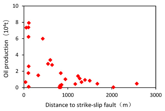
Figure 10.
The oil production of the carbonate rocks vs. distance to strike-slip fault in the western area.
Together with the reactivation of the thrust fault and strike-slip fault after the deposition of the Lianglitage Formation, the fault-related uplift resulted in the appearance of karstic fracture-cave reservoirs in the faulted blocks in the eastern area [12]. In the western segment, there was much stronger strike-slip faults activity, more than the thrust fault activity in the Ordovician carbonates. The fracture-cave reservoirs developed well along the strike-slip fault damage zones (Figure 9) that supported most high production wells in the Ordovician carbonate rocks. In the central segment, fractured reservoirs mainly occurred along the strike-slip fault damage zones. For example, well T82 has been assumed to be a reef-shoal reservoir [19], whereas the high production was from the fractured reservoir rather than the low production from the upper good matrix reservoir. The seismic data suggested that T82 is located along strike-slip fault FI23 (Figure 4). The well T82 had a much greater but less stable production quota compared to that shown in the fractured reservoir. The seismic and production data indicate that the “sweet spots” of fractured reservoirs generally occurred along the strike-slip fault zones (Figure 9). Particularly, the reef-shoal complex had more and wider fractured reservoirs along the strike-slip fault damage zone.
The reef-shoal reservoirs developed well alongside the carbonate platform margin in the central Tarim Basin (Figure 2). However, the matrix reservoir with its low porosity (less than <4%) and permeability (less than 0.5 mD) could not support commercial oil/gas production in the deep subsurface [13]. This is comparable to the global deep tight reservoir [6,37]. It has been suggested that the Ordovician carbonate reservoirs have experienced a long diagenetic history, and most primary porosity has been excluded to show secondary porosity in the central Tarim Basin [28,29,30]. The high production wells suggested that the fracture enhanced the secondary porosity, particularly of the “sweet spots” of the deep fractured reservoirs along the strike-slip fault zones.
The seismic reservoir data suggested that fracture networks could have developed along the fault zone, which is more than 1000 m wide [14,15]. The fracture porosity is generally lower than 0.1%, while the dissolution porosities along the fracture network could be increased by more than two times along the fault zone. Furthermore, the fracture network controls the permeability of the tight carbonate reservoirs. The permeability of the tight carbonates is often less than 1 mD. In contrast, the permeability in fractured reservoirs varies considerably in the range of 0.1–1000 mD, which could be increased by 1–3 orders of magnitude (Figure 6). The fracture-vug and fracture-cave reservoirs in the carbonate fault damage zones have a much higher porosity (>6%) and permeability (>5 mD). Therefore, the fractured reservoirs are a favorable “sweet spot” for high gas production. Unfortunately, the uniform pattern of the development wells by conventional methods could not meet the localized “sweet spot” development in the deep reef-shoal reservoirs.
The fractured reservoirs also show a distinct power-law with the distance to the fault zones (Figure 7 and Figure 10), which is in agreement with the poro-perm pattern of the Ordovician carbonate rocks of the Tarim Basin [13,38] and other places [39]. As the reef-shoal reservoirs have been impacted by strike-slip fault activities, fractured reservoirs have developed alongside the strike-slip fault zone due to fault-related dissolution [12,13]. The three major elements: microfacies, faulting, and dissolution, control the development and distribution of “sweet spot” reservoirs along the platform margin. The tight reef-shoal reservoirs occurred widely alongside the platform margin in the central Tarim Basin, but the “sweet spots” of fractured reservoirs developed well only in localized fault damage zones. Furthermore, the distribution of “sweet spots” in the fractured reservoirs is varied along the strike-slip fault zones (Figure 9). In this context, the localized fractured reservoirs along the strike-slip fault damage zones are the major drilling targets for high oil/gas production in the reef-shoal reservoirs.
6. Conclusions
In spite of the complicated characteristics of the Ordovician reef-shoal reservoirs in the central Tarim Basin, we propose the following major conclusions.
- The NE-trending strike-slip faults intersected the NW-trending platform margin, forming multiple segments. The development of strike-slip faults affects prepositional landforms and the subsequent segmentation of varied microfacies and reservoirs along the extent of the platform margin.
- Using the strike-slip fracturing and dissolution processes, the porosity and permeability in the tight reef-shoal reservoirs could be increased more than 2–5 times and by 1–2 orders of magnitude. These processes play a significant role in the development of the “sweet spots” in fractured reservoirs along strike-slip fault damage zones.
- High-production wells are correlated with the “sweet spots” of fractured reservoirs alongside the strike-slip fault damage zones. The “sweet spots” of fractured reservoirs in tight reef-shoal bodies could be major targets for commercial exploitation in deep, tight reef-shoal reservoirs. New reservoir description and exploitation technologies are urgently needed for the extraction of fractured reservoirs in the deep subsurface.
Author Contributions
Conceptualization, G.W. and J.H.; methodology, Y.Z. (Yawen Zhao) and G.W.; software, C.S. and Y.Z. (Yawen Zhao); investigation, Y.Z. (Yawen Zhao) and G.W.; writing, G.W., Y.Z. (Yawen Zhao) and N.S.; data curation and visualization, W.Y. and Y.Z. (Yawen Zhao); supervision, Y.Z. (Yintao Zhang) and J.H.; funding acquisition, Y.Z. (Yintao Zhang) and J.H. All authors have read and agreed to the published version of the manuscript.
Funding
Prospective Basic Research Project of CNPC (2021DJ1502) and the National Natural Science Foundation of China (Grant No. 9195520441472103).
Institutional Review Board Statement
Not applicable.
Informed Consent Statement
Not applicable.
Data Availability Statement
Not applicable.
Acknowledgments
We are grateful to Zhenyu Wang, Yunfeng Zhang, Xinli Liu, Xinnian Liu and Chunguang Shen for their help. Comments provided by editors and reviewers of the manuscript are much appreciated and were very helpful in improving the manuscript.
Conflicts of Interest
The authors declare no conflict of interest.
References
- Akbar, M.; Vissapragada, B.; Alghamdi, A.H.; Allem, D.A. Snapshot of carbonate reservoir evaluation. Oilfield Rev. 2000, 12, 20–21. [Google Scholar]
- Garland, J.; Neilson, J.; Laubach, S.E.; Whidden, K.J. Advances in carbonate exploration and reservoir analysis. Geol. Soc. Lond. Spec. Publ. 2012, 370, 1–15. [Google Scholar] [CrossRef]
- Zhang, G.Y.; Ma, F.; Liang, Y.B.; Zhao, Z.; Qin, Y.Q.; Liu, X.B.; Zhang, K.B.; Ke, W.L. Domain and theory-technology progress of global deep oil & gas exploration. Acta Petrol. Sin. 2015, 36, 1156–1166, (In Chinese with English abstract). [Google Scholar]
- Zou, C.N.; Zhai, G.M.; Zhang, G.Y.; Wang, H.J.; Zhang, G.S.; Li, J.Z.; Wang, Z.M.; Wen, Z.X.; Ma, F.; Liang, Y.B.; et al. Formation, distribution, potential and prediction of global conventional and unconventional hydrocarbon resources. Pet. Explor. Dev. 2015, 42, 13–25. [Google Scholar] [CrossRef]
- Sun, L.D.; Zou, C.N.; Zhu, R.K.; Zhang, Y.H.; Zhang, S.C.; Zhang, B.M.; Zhu, G.Y.; Gao, Z.Y. Formation, distribution and potential of deep hydrocarbon resources in China. Pet. Explor. Dev. 2013, 40, 687–695. [Google Scholar] [CrossRef]
- Rashid, F.; Glover, P.W.J.; Lorinczi, P.; Collier, R.; Lawrence, J. Porosity and permeability of tight carbonate reservoir rocks in the north of Iraq. J. Pet. Sci. Eng. 2015, 133, 147–161. [Google Scholar] [CrossRef]
- Wu, G.H.; Zhao, K.Z.; Qu, H.Z.; Nicola, S.; Zhang, Y.T.; Han, J.F.; Xu, Y.F. Permeability distribution and scaling in multi-stages carbonate damage zones: Insight from strike-slip fault zones in the Tarim Basin, NW China. Mar. Pet. Geol. 2020, 114, 104208. [Google Scholar] [CrossRef]
- Abouelresh, M.O.; Mahmoud, M.; Radwan, A.E.; Dodd, T.J.H.; Kong, L.Y.; Hassan, H.F. Characterization and classification of the microporosity in the unconventional carbonate reservoirs: A case study from Hanifa Formation, Jafurah Basin, Saudi Arabia. Mar. Pet. Geol. 2022, 145, 105921. [Google Scholar] [CrossRef]
- Chen, D.Z.; Tucker, M.E.; Zhu, J.Q.; Jiang, M.S. Carbonate platform evolution: From a bioconstructed platform margin to a sand-shoal system (Devonian, Guilin, South China). Sedimentology 2002, 49, 737–764. [Google Scholar] [CrossRef]
- Basilone, L.; Sulli, A.; Morticelli, M.G. Integrating facies and structural analyses with subsidence history in a Jurassic–Cretaceous intraplatform basin: Outcome for paleogeography of the Panormide Southern Tethyan margin (NW Sicily, Italy). Sediment. Geol. 2016, 339, 258–272. [Google Scholar] [CrossRef]
- Wen, L.; Ran, Q.; Tian, W.; Liang, H.; Zhong, Y.; Zou, Y.; Su, C.; Wu, G. Strike-slip fault effects on diversity of the Ediacaran mound-shoal distribution in the Central Sichuan intracratonic basin, China. Energies 2022, 15, 5910. [Google Scholar] [CrossRef]
- Wu, G.H.; Yang, H.J.; He, S.; Cao, S.J.; Liu, X.; Jing, B. Effects of structural segmentation and faulting on carbonate reservoir properties: A case study from the Central Uplift of the Tarim Basin, China. Mar. Pet. Geol. 2016, 71, 183–197. [Google Scholar] [CrossRef]
- Yang, H.J.; Wu, G.H.; Nicola, S.; Sun, C.H.; Qing, H.R.; Han, J.F.; Zhang, J.W. Characterization of reservoirs, fluids, and productions from the Ordovician carbonate condensate field in the Tarim Basin, northwestern China. AAPG Bulletin 2020, 104, 1567–1592. [Google Scholar] [CrossRef]
- Wang, Q.H.; Zhang, Y.T.; Xie, Z.; Zhao, Y.W.; Zhang, C.; Sun, C.; Wu, G.H. The Advance and challenge of seismic technique on the ultra-deep carbonate reservoir exploitation in the Tarim Basin, Western China. Energies 2022, 15, 7653. [Google Scholar] [CrossRef]
- He, X.; Guo, G.; Tang, Q.; Wu, G.; Xu, W.; Ma, B.; Huang, T.; Tian, W. The advances and challenges of the Ediacaran fractured reservoir development in the central Sichuan Basin, China. Energies 2022, 15, 8137. [Google Scholar] [CrossRef]
- Benmadi, M.; Sayantan, G.; Roger, S.; Kurt, M.; Mashhad, F. Practical aspects of upscaling geocellular geological models for reservoir fluid flow simulations: A case study in integrating geology, geophysics, and petroleum engineering multiscale data from the Hunton Group. Energies 2020, 13, 1604. [Google Scholar]
- Tang, Q.; Tang, S.; Luo, B.; Luo, X.; Feng, L.; Li, S.; Wu, G. Seismic description of deep strike-slip fault damage zone by steerable pyramid method in the Sichuan Basin, China. Energies 2022, 15, 8131. [Google Scholar] [CrossRef]
- Tian, J.; Wang, Q.H.; Yang, H.J.; Li, Y. Petroleum Exploration History and Enlightenment in Tarim Basin. Xinjiang Pet. Geol. 2021, 42, 272–282, (In Chinese with English abstract). [Google Scholar]
- Wang, Z.; Sun, C.; Yang, H.; Zhou, C.; Zhang, Z. Formation pattern of upper ordovician reef-bank complex along the Tazhong Slopebreak I, tarim block, NW China. Acta Geol. Sin. 2010, 84, 546–552. [Google Scholar]
- Liu, J.Q.; Li, Z.; Huang, J.C.; Yang, L. Distinct sedimentary environments and their influences on carbonate reservoir evolution of the Lianglitag Formation in the Tarim Basin, Northwest China. Sci. China-Earth Sci. 2012, 55, 1641–1655. [Google Scholar] [CrossRef]
- Gao, D.; Lin, C.S.; Yang, H.J.; Zuo, F.F.; Cai, Z.Z.; Zhang, L.J.; Liu, J.Y.; Li, H. Microfacies and depositional environments of the Late Ordovician Lianglitage Formation at the Tazhong Uplift in the Tarim Basin of Northwest China. J. Asian Earth Sci. 2014, 83, 1–12. [Google Scholar] [CrossRef]
- Zhang, Y.F.; Tan, F.; Sun, Y.B.; Pan, W.Q.; Wang, Z.Y.; Yang, H.Q.; Zhao, J.X. Differences between reservoirs in the intra-platform and platform margin reef-shoal complexes of the Upper Ordovician Lianglitag Formation in the Tazhong oil field, NW China, and corresponding exploration strategies. Mar. Pet. Geol. 2018, 98, 66–78. [Google Scholar] [CrossRef]
- Yang, H.J.; Wu, G.H.; Han, J.F.; Wang, X.F.; Ji, Y.G. Characteristics of hydrocarbon enrichment along the Ordovician carbonate platform margin in the central uplift of Tarim Basin. Acta Petrol. Sin. 2007, 28, 26–30, (In Chinese with English abstract). [Google Scholar]
- Wu, G.H.; Chen, L.S.; Xu, Z.M.; Han, J.F.; Xi, Q. Mechanism of hydrocarbon pooling in the Ordovician carbonate reservoirs in Tazhong area of the Tarim basin. Nat. Gas Ind. 2008, 28, 20–22, (In Chinese with English abstract). [Google Scholar]
- Wu, G.H.; Yang, H.J.; Qu, T.L.; Li, H.W.; Luo, C.S.; Li, B.L. The fault system characteristics and its controlling roles on marine carbonate hydrocarbon in the Central uplift, Tarim Basin. Acta Petrol. Sin. 2012, 28, 793–805, (In Chinese with English abstract). [Google Scholar]
- Li, X.G.; Xu, G.Q.; Han, J.F.; Shen, Z.M.; Wu, S.H.; Luo, C.S.; Song, G.L.; Chen, H.; Ju, Y. Application of a new method for quantitative calculating of fault-related fracture: A case study from Lianglitage Formation in Tazhong X well area, Tarim Basin, China. J. Jilin Univ. (Earth Sci. Ed.) 2012, 42, 344–352, (In Chinese with English abstract). [Google Scholar]
- Li, Z.H.; Zhang, L.Q.; Chen, X.; Zhao, H.T.; Jin, Q.Q. Logging identification of fractured-vuggy carbonate reservoirs: Case study from the second section of Lianglitage Formation in the eastern part of Tazhong area. Nat. Gas Geosci. 2019, 30, 1805–1814. [Google Scholar]
- Wu, G.H.; Pang, X.Q.; Li, Q.M.; Yang, H.J. Structural Characteristics in Intracratonic Carbonate Rocks and Its Implication for Oil/Gas Accumulation: A Case Study in the Tarim Basin, China; Chinese Science Press: Beijing, China, 2016; pp. 1–344. (In Chinese) [Google Scholar]
- Zhang, L.J.; Wu, G.H.; He, S.; She, Z.C.; Pan, Y.Y. Structural diagenesis in carbonate fault damage zone: A case study of the No. 1 fault zone in the Tarim basin. Acta Geol. Sin. 2016, 32, 922–934, (In Chinese with English Abstract). [Google Scholar]
- Zhang, H.; Cai, Z.X.; Qi, L.X.; Yun, L. Diagenesis and origin of porosity formation of Upper Ordovician carbonate reservoir in northwestern Tazhong condensate field. J. Nat. Gas Sci. Engin. 2017, 38, 139–158. [Google Scholar] [CrossRef]
- Zhang, Z.P.; Kang, Y.; Lin, H.X.; Han, J.; Zhao, R.; Zhu, X.X.; Ru, Z.X.; Xiao, C.Y. A study on the reservoir controlling characteristics and mechanism of the strike slip faults in the northern slope of Tazhong uplift, Tarim Basin, China. Arab. J. Geosci. 2021, 14, 1–18. [Google Scholar] [CrossRef]
- Yu, J.B.; Li, Z.; Yang, L. Fault system impact on paleokarst distribution in the Ordovician Yingshan Formation in the central Tarim basin, northwest China. Mar. Pet. Geol. 2016, 71, 105–118. [Google Scholar] [CrossRef]
- Zhu, G.Y.; Liu, W.; Wu, G.H.; Ma, B.S.; Nance, R.D.; Wang, Z.C.; Xiao, Y.; Chen, Z.Y. Geochemistry and U-Pb-Hf detrital zircon geochronology of metamorphic rocks in terranes of the West Kunlun Orogen: Protracted subduction in the northernmost Proto-Tethys Ocean. Precambrian Res. 2021, 363, 106344. [Google Scholar] [CrossRef]
- Huang, H.D.; Yuan, S.Y.; Zhang, Y.T.; Zeng, J.; Mu, W.T. Use of nonlinear chaos inversion in predicting deep thin lithologic hydrocarbon reservoirs: A case study from the Tazhong oil field of the Tarim Basin, China. Geophysics 2016, 81, 221–234. [Google Scholar] [CrossRef]
- Li, X.W.; Li, J.Y.; Liu, Y.L.; Ma, P.L.; Bi, J.Y.; Zhang, L.L.; Zhou, H.B.; Chen, Y.R.; Zhang, L. Pre-stack anisotropy fractures detection based on OVT domain gather data and its application in ultra-deep burial carbonate rocks. Earth Sci. 2020, 9, 210–218. [Google Scholar] [CrossRef]
- Wu, G.H.; Ma, B.S.; Han, J.F.; Guan, B.Z.; Chen, X.; Yang, P.; Xie, Z. Origin and growth mechanisms of strike-slip faults in the central Tarim cratonic basin, NW China. Pet. Explor. Dev. 2021, 48, 595–607. [Google Scholar] [CrossRef]
- Shanley, K.W.; Cluff, R.M.; Robinson, J.W. Factors controlling prolific gas production from low-permeability sandstone reservoirs. AAPG Bull. 2004, 88, 1083–1121. [Google Scholar] [CrossRef]
- Wu, G.H.; Gao, L.H.; Zhang, Y.T.; Ning, C.Z.; Xie, E. Fracture attributes in reservoir-scale carbonate fault damage zones and implications for damage zone width and growth in the deep subsurface. J. Struct. Geol. 2019, 118, 181–193. [Google Scholar] [CrossRef]
- Torabi, A.; Berg, S.S. Scaling of fault attributes: A review. Mar. Petrol. Geol. 2011, 28, 1444–1460. [Google Scholar] [CrossRef]
Disclaimer/Publisher’s Note: The statements, opinions and data contained in all publications are solely those of the individual author(s) and contributor(s) and not of MDPI and/or the editor(s). MDPI and/or the editor(s) disclaim responsibility for any injury to people or property resulting from any ideas, methods, instructions or products referred to in the content. |
© 2023 by the authors. Licensee MDPI, Basel, Switzerland. This article is an open access article distributed under the terms and conditions of the Creative Commons Attribution (CC BY) license (https://creativecommons.org/licenses/by/4.0/).