Article

Incorporating Landscape Dynamics in Small-Scale Hydropower Site Location Using a GIS and Spatial Analysis Tool: The Case of Bohol, Central Philippines

by
Imelida Torrefranca
1,2,*,
Roland Emerito Otadoy
3,4 and
Alejandro Tongco
1
1
Graduate School of Engineering, University of San Carlos, Talamban, Cebu City 6000, Philippines
2
Department of Agricultural and Biosystems Engineering, Bohol Island State University, Bilar 6319, Philippines
3
Theoretical, Computational Sciences and Engineering Group, Department of Physics, University of San Carlos, Talamban, Cebu City 6000, Philippines
4
Center for Geoinformatics and Environmental Solutions, University of San Carlos, Talamban, Cebu City 6000, Philippines
*
Author to whom correspondence should be addressed.
Energies 2022, 15(3), 1130; https://doi.org/10.3390/en15031130
Submission received: 14 October 2021 / Revised: 13 January 2022 / Accepted: 14 January 2022 / Published: 3 February 2022
(This article belongs to the Special Issue Renewable Energy Resource Assessment)

Abstract

:
Hydropower depends on the elevation head and water flow of a river. However, other factors must be considered, such as the risk associated with surface processes and environmental factors. The study aims to analyze a landscape’s dynamics and locate potential sites for small-scale hydropower systems (<10 MW) using a geographic information system, the curve number method, and the TopoToolbox with a digital elevation model and available spatial datasets. Across Bohol Island in the central Philippines, the study found 94 potential sites with hydraulic heads ranging from 20–62.4 m, river discharges between 0.02 to 9.71 m3/s, and a total hydropower capacity of 13.595 MW. The river profile analysis classified the sites to five levels of risk to geo-hazards, with three-fourths of the sites being at ‘high’ to ‘very high’ risk levels while more than 50% of the total power can be generated in ‘low’ risk areas. Land-use and population constraints reduced the sites to 25 and the hydropower capacity by 60%. Although limited to the table assessment phase of hydropower development, the study showed the potential of small-scale hydropower systems in the study area, their spatial distribution, and the risk associated with each site. The study results provided data-limited resource managers’ and energy planners’ insights in targeting potential locations and minimizing field investigation costs and time.

Graphical Abstract

1. Introduction

The increasing environmental issues associated with fossil-based energy production, depleting sources, and increasing energy demand have led to intensifying use, development, and exploration of alternative renewable energy resources [1,2,3]. For tropical islands with rich natural resources that suffer from nature’s vicissitudes adversely affecting energy supply, searching for more energy sources becomes urgent [4].
Hydropower is one of the world’s renewable energy resources. A high-resolution assessment of global hydropower potential by Hoes et al. [2] revealed that about a third of the annual energy requirement can be provided by hydropower but existing hydropower plants produced only 3% of the yearly energy needs. One of the notable features of hydropower sources, especially the small-scale systems (SHP), is the lesser greenhouse gas emission [1,5,6]. The run-of-river small hydropower has become more cost-effective than mini-grids powered by diesel gen-sets due to falling energy costs [7]. IRENA [7] commended the micro-hydro power systems as a better option for household lighting than the commonly used solar PV in areas where the resource is available for a cluster of households. The SHPs supported rural development in many developing countries in Asia and Africa [8]. Such systems helped improve remote areas’ productivity and contributed directly to the development of women by powering small agro-industries usually performed by hand and almost entirely by women [8].
Recent studies compare the impacts of SHP and large-scale hydropower (LHP) systems. Different indicators were evaluated and the demarcations between scales also differ which led to contrasting results. For example, in Duero Basin, Spain, Mayor et al. [9] found that the cumulative impacts of the deployment of many SHPs outweighed the impacts of a few LHP upon evaluating indicators under three categories of energy, water, and environment. An installed capacity of 10 MW demarcates the SHP from the LHP was used in the study [9]. In contrast, Zhang et al. [6] analysis in Tibet, China, found that SHPs have reduced externalities compared to LHPs, considering greenhouse gas emission translated into CO2 equivalent: SHPs and LHPs produced an average of 5.1 and 29.2 g CO2-e per kWh, respectively. Reservoir impoundment and occupation were the critical components of the total externality of LHP, the study emphasized. One implication of their study was that a higher power density can decrease externality, which favor the SHP systems. In this study of Zhang et al. [6], an installed capacity of 50 MW was used to differentiate the two hydropower scales. A unified system of evaluation particularly on the indicators to be assessed and the scale to delineate between SHP and LSP may be put forward to resolve opposing results.
The hydropower potential in the Philippines is high [7,10], with untapped resources amounting to 13,097 MW. In 2018, the hydropower share was only 9.4% of the total generation mix of 99,765 GWh [11]. The ADB [10] associated the low hydropower utilization in the country to ‘global isolation and the lack of financial and technical capacity’.
Hydropower produces electrical energy from moving water converted through mechanical turbines. The amount of power generated is directly proportional to the head and the flow. In particular, the small-scale hydropower systems depend on the available head and sufficient water flow in the river [12]. Along river channels, locating suitable sites for hydropower plants is a bit challenging [13,14]. A range of factors including hydraulic head, catchment area, flow characteristics, and sensitive environmental issues such as biodiversity and land use pattern must be critically considered in finding potential sites. In response, several studies have developed methods and approaches for identifying potential hydropower sites.
In the last few decades, geographic information systems coupled with hydrologic models were the primary tools employed to identify potential sites for hydropower development. In Pakistan’s data-scarce Kunhar River Basin, Moiz et al. [13] developed a geographic information system-based decision-support system for decision-makers evaluating potential hydropower schemes. The system optimized the site selection process for run-of-river small hydropower plants using topographic and hydrologic factors. Bayazit et al. [15] applied GIS-based hydrological modeling with a topographical and meteorological dataset to analyze the hydropower potential of the Bilecik Regional Sakarya Basin, Turkey. Thin et al. [11] integrated GIS and the Soil and Water Assessment Tool (SWAT) and developed a GIS-based tool using Python to locate potential hydropower in Myanmar’s Myitnge River Basin. Similarly, Sekac et al. [15] adopted GIS and remote sensing technology to identify potential hydropower sites in the Busu River Catchment in Papua New Guinea. Sammartano et al. [16] also employed GIS and SWAT model to determine the optimal potential run-of-river sites in Taw at Umberleigh Catchment of South West England. Their study assessed the small hydropower projects’ environmental and economic feasibility and conducted a multi-objective analysis to highlight profitable schemes. In the Philippines, a geographic information system and a hydrologic model were employed to identify potential hydropower sites in two separate river basins in Mindanao, Philippines [17,18]. Both studies explored possible renewable energy resources to address the perennial energy crisis through hydropower development. A comprehensive method was developed in the study of [19] to ensure cost-effectiveness and high-performance hydropower projects in the Fomanat Plain of Gilan, Iran. In Estonia, Tamm and Tamm [20], proposed a virtual hydropower assessment method in identifying other potential locations in all large rivers where hydropower plants already existed and found several suitable sites for mini- and micro-hydro types.
The initial assessment for potential hydropower sites centered on topographic and hydrologic factors. Initial investigations commonly assessed larger rivers or major watersheds in an area, neglecting the potential of smaller catchments. The conventional approach may have overlooked the potential of small systems in these areas, which may be beneficial to small clusters of users.
Another observation is that existing studies gave less attention to geomorphic features in a landscape related to surface processes and, thereby, to geomorphic hazards. Geomorphic hazards [21] ‘are natural processes until they intersect with human activities and settlements’. These hazards are either natural or anthropogenic to some degree and usually happen along or adjacent to river channels. Hydropower facilities are sited along or adjacent to river channels, and the stability of hillslopes and channels is critical to the sustainability of the engineering structures [22,23]. Although these factors are critically evaluated in the subsequent phase of system development, it is valuable to have such information earlier to have a priority list of potential sites.
Geomorphologists analyzed river profiles to extract information on landscape evolution and the processes that shape the topography of landscapes [24], linking climate, tectonic and surface processes across a landscape [25]. The geomorphic index such as the river steepness index [22,24] and the presence of knickpoints [26] are proxies of natural surface processes. As Boulton [26] noted, steeper channels and regions undergoing higher erosion and uplift rates, can be recognized with river profile analysis as indicated by the high river steepness index. Similarly, the study of Castillo et al. [27] in western Mexico rivers found high river steepness index values that suggests high rock uplift and erosion rates that control the topography of river basins. The river steepness index is a commonly used index to analyze river profiles to infer erosion rates, bedrock erodibility and highlight areas of tectonic activity [24]. Knickpoints, on the other hand, are sharp changes in the channel slope [28] that reflects conditions and processes associated with erosion, lithological changes, and uplift rates. Boulton [26] noticed that knickpoints formed in response to changes in uplift rates are found in areas where river steepness index is high. Chen et al. [29] found steep rivers with many tectonic knickpoints in the eastern flank of the central range of the Taiwanese island where the mountains are under rapid collisional processes. Low river steepness index values indicate low uplift rates [29].
The study presents a rapid method of assessing the dynamics of a landscape for identifying potential sites for small-scale hydropower projects (<10 MW). Specifically, the study aims to (a) examine the topography from a digital elevation model to locate potential sites along river channels, (b) estimate surface runoff using the CN method, (c) compute the hydropower capacity of each site, (d) investigate the geometric indices associated with geo-hazards and (e) analyze the existing land-use and population data. The study is limited to the initial stage of hydropower development. It is applied to an island landscape where natural disasters like typhoons and earthquakes challenge energy supply and accessibility. Results are presented as maps showing the landscape’s hydropower potential, the spatial distribution of potential sites, and the risk levels associated with each site. The study results are expected to benefit local resource managers, decision-makers, and energy planners faced with limited data for analysis, in identifying potential sites, targeting directly potential areas and minimizing field investigation costs and time.

2. Methods

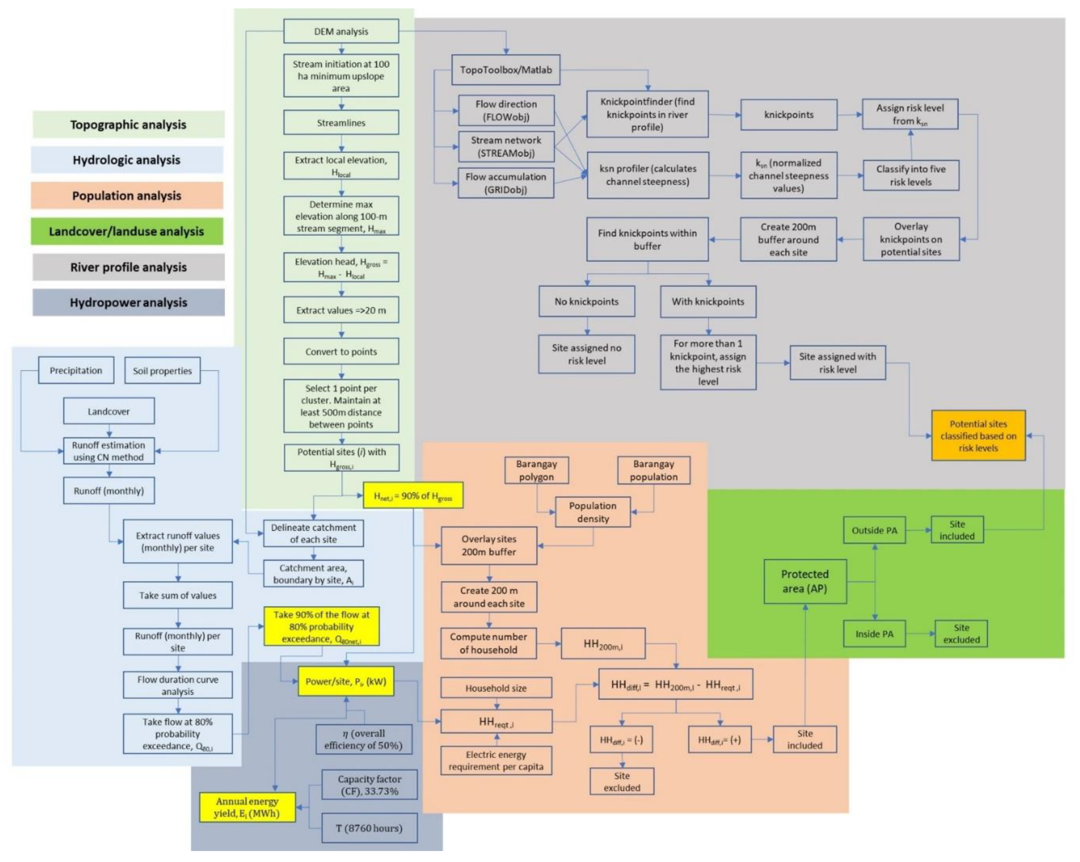
Figure 1 shows the workflow of the analysis, and a detailed discussion follows. Data processing started with a topographic analysis that defined the streamlines and determined the required elevation head. Next, the hydrologic analysis provided an estimate of the flow rate passing through each identified potential site. The two primary factors, elevation head, and flow are inputs to compute the potential hydropower at each site. Then, the river profile analysis determined the geomorphic indices of surface processes associated with channel stability. Lastly, we considered population and land use in the constraint analysis.

2.1. Datasets

The study gathered the required input datasets from several sources as given in Table 1 and processed them following Figure 1 (a detailed process flow is given in Appendix A Figure A1). Table 1 presents a list of all the datasets used, their sources, and data format.
Digital elevation model (DEM). The digital elevation data is critical in the study since this is the primary data where the rest of the analysis depends. In a GIS platform, we preprocessed a DEM and used it to delineate watersheds, determine drainage lines, and compute elevation differences. The DEM is also the primary input to a terrain analysis tool for river profile analysis.
Global datasets. Due to the limited availability of local soil and landcover data, we used freely available global datasets on monthly precipitation, hydrologic soil group, and landcover. The global hydrologic soil group (HYSOGs250m) for curve number-based runoff modeling [30] represents a globally consistent, gridded dataset of hydrologic soil group with a geographical resolution of 1/480 decimal degrees, equivalent to a projected resolution of approximately 250-m. The soil texture classes and depth to bedrock information provided by the Food and Agriculture Organization soilGrids250m system are the bases for classifying the HSG. The Copernicus Global Land Service [31] global landcover dataset provides spatial information on different types (classes) of the Earth’s surface physical coverage, e.g., forests, grasslands, croplands, lakes, and wetlands. We used the annual dataset, a moderate resolution landcover map targeting landcover detection and its changes.
Climate data. The WorldClimv2.1 climate data for 1970–2000 [32] provide monthly total precipitation. This dataset was downloaded and used in the runoff determination using the CN method.
Local flow and rainfall data. Flow and rainfall data are available from the monitoring activity of a hydropower plant. The study used the flow and the rainfall data from local rain gauges to describe the area’s hydrology but not estimate the surface runoff.
Population data. The study used the 2015 census of the Philippine Statistics Authority (PSA) population data at the barangay (village) level. The data were linked to a barangay shapefile to create a raster surface describing the spatial variability of population density across the study area.

2.2. Topographic Analysis

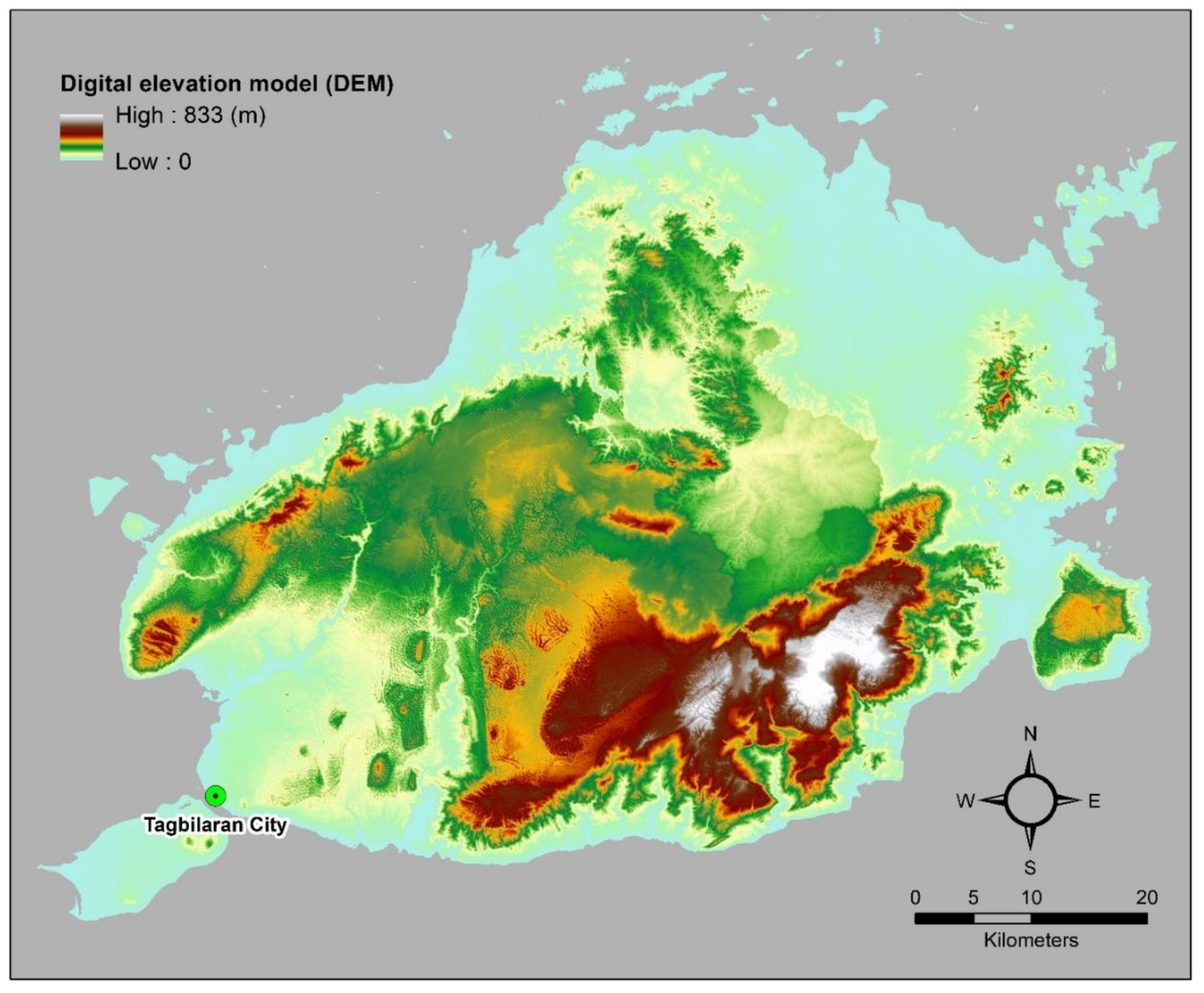
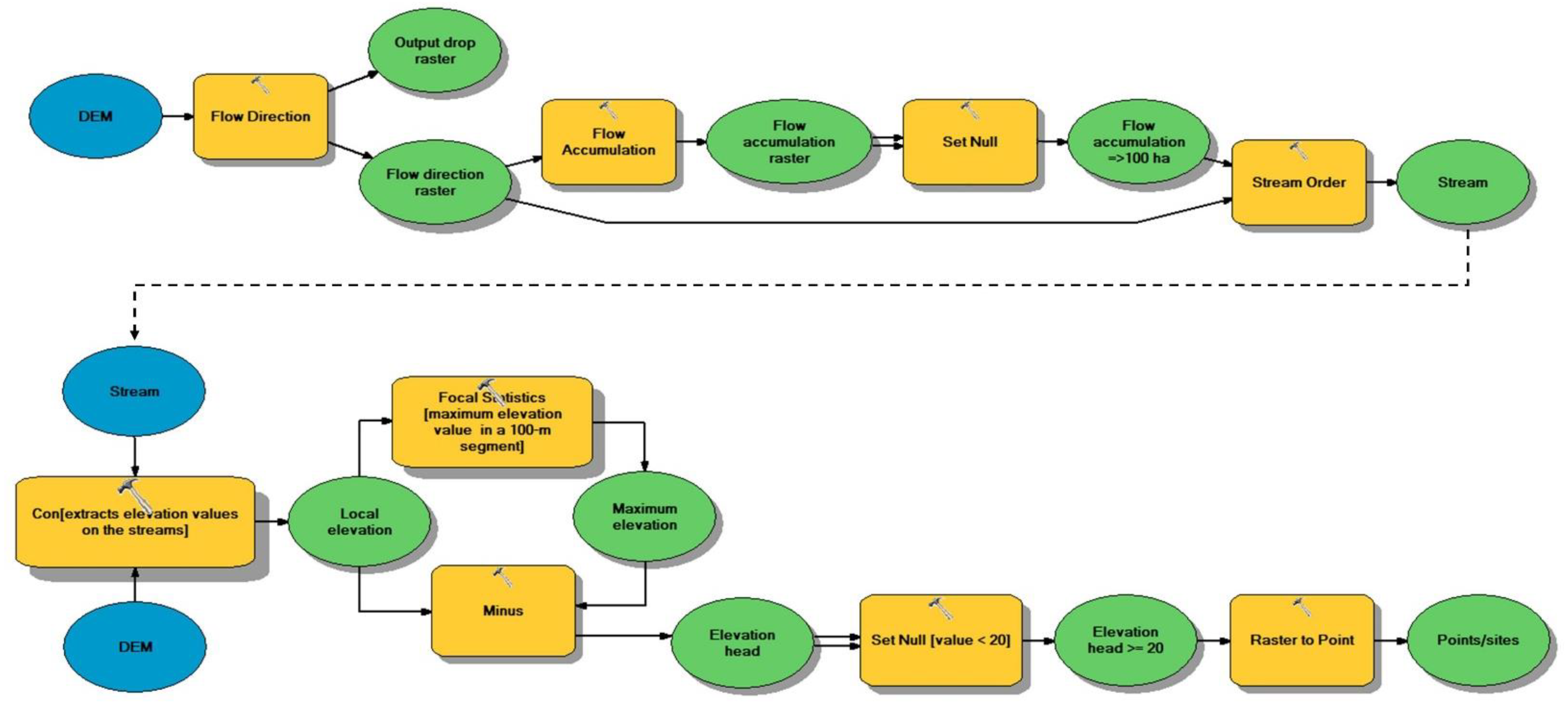
The topographic analysis examined a DEM (see Appendix A Figure A2) to locate potential sites in the study area. The process is outlined in a model builder created in ArcGIS, as shown in Figure 2. The model builder used a DEM to create the flow direction and flow accumulation rasters. The flow direction raster shows the flow direction from each cell to its steepest downslope neighbor, while the flow accumulation raster shows the accumulated flow into each cell. From the flow accumulation raster, the cells with values of at least 10,000 (equivalent to 100 ha upslope area) were selected using the SetNull tool, creating a new flow accumulation raster. The new flow accumulation raster was used as an input to create the stream raster. Then, the elevation values following the stream raster were extracted and analyzed. The Focal Analysis Tool with a rectangular neighborhood of the same height and width at 100 m was used to determine the maximum elevation in a 100-m channel segment. The channel length was adopted from the study by Sammartano et al. [16]. The elevation head is the difference between the maximum elevation and the local elevation rasters, stored as the elevation head raster. From the elevation head raster, raster values equal to or greater than 20 m (≥20 m) were selected using the Set Null tool. The 20 m minimum head which was adopted from previous studies in the study area [33] and in Uganda [34]. The minimum head value anticipated the low flows from the small catchment and from the upper part of the watersheds which can still produce power at 20 m head or higher. These selected raster values were converted into point vector.
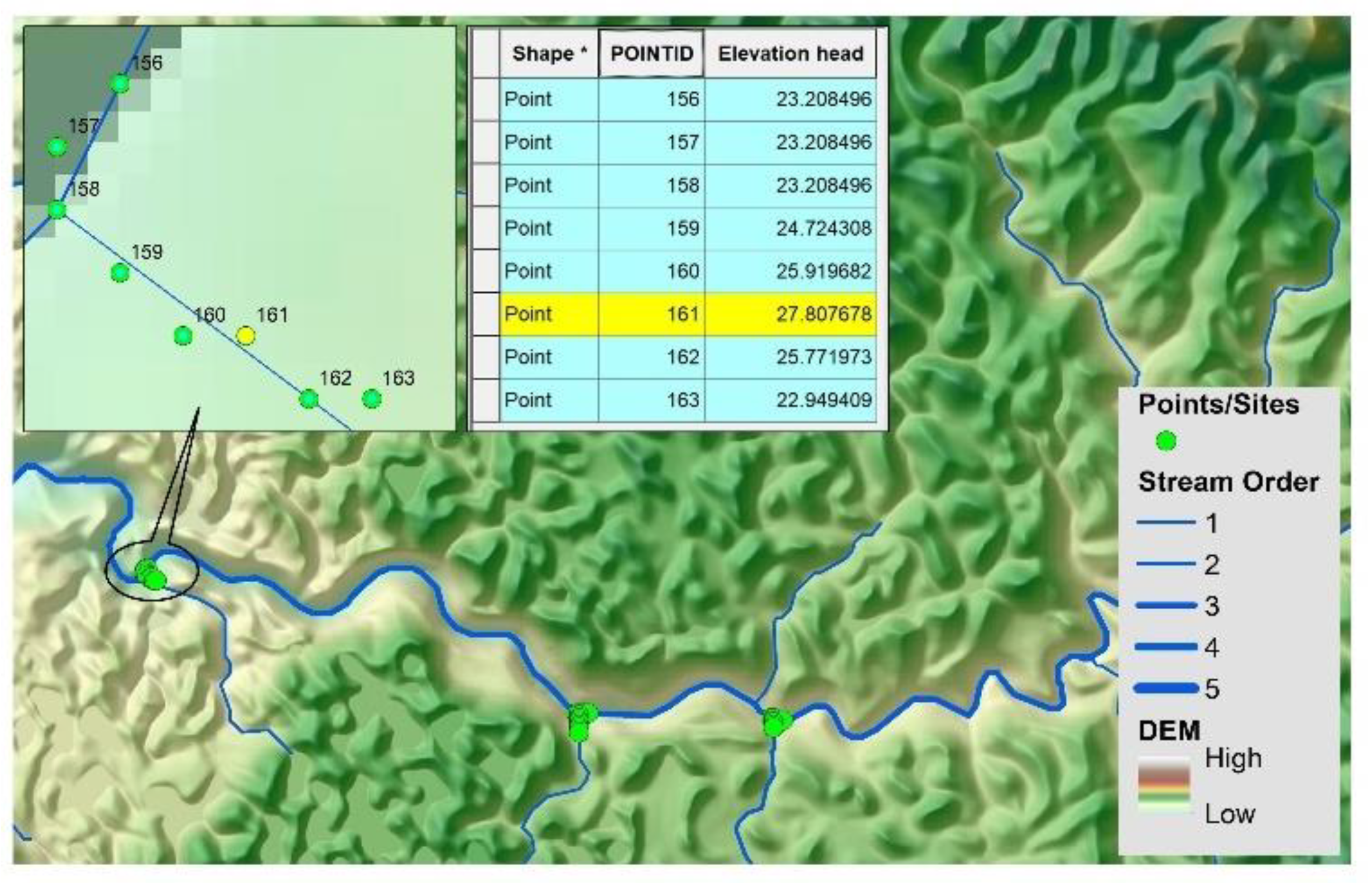
The conversion resulted in clusters of points, as shown in Figure 3, where points were found to assemble around channel segments. For each cluster, a point was selected based on the elevation head value and the location of the point. For instance, in a cluster found at the convergence of two different stream orders, high consideration is given to a point along the higher-order stream because the flow is expected to be higher in high-order stream than in low-order stream. The study manually picked a point to represent each cluster. A distance of at least 500 m between selected points from each cluster was maintained by using the distance tool. The 500-m minimum site spacing is commonly adopted (ex. [13,33,35]) to allow river ecosystem rejuvenation. These selected points were the potential sites for small-scale hydropower.

2.3. Runoff Estimation Using CN Method

Several studies used the USDA-CRS curve number (CN) method for estimating surface runoff [36,37,38]. Due to its simplicity, the study adopted the CN method to estimate direct surface runoff at each identified potential site. The CN method requires only precipitation values and a single parameter called CN to estimate the direct surface runoff using the equation:
q = ( R I a ) 2 / ( R I a + S ) ,
where q is the accumulated runoff or rainfall excess (mm), R is the rainfall depth (mm), I a is the initial abstraction (mm), and S is the potential maximum retention (mm). USDA-CRS [39] estimated I a as 20% of S based on its extensive database. Meanwhile, S is expressed in terms of CN as:
S = ( 25400 / CN )     254 .
With this, (1) is written as:
q = ( R 0.2   S ) 2 / ( R + 0.8   S ) .  
Equation (2) derived the S raster and then (3) computed the monthly surface runoff q with the corresponding R monthly precipitation data.
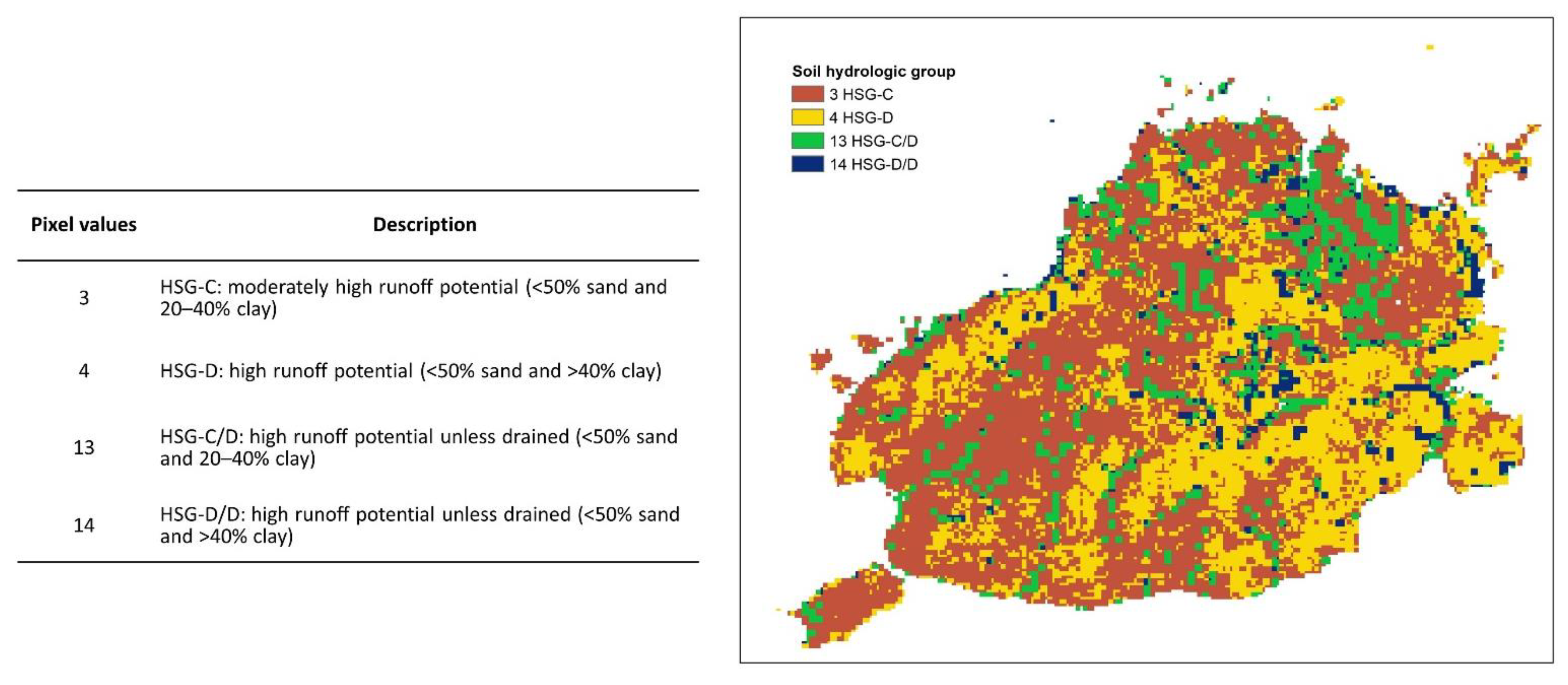
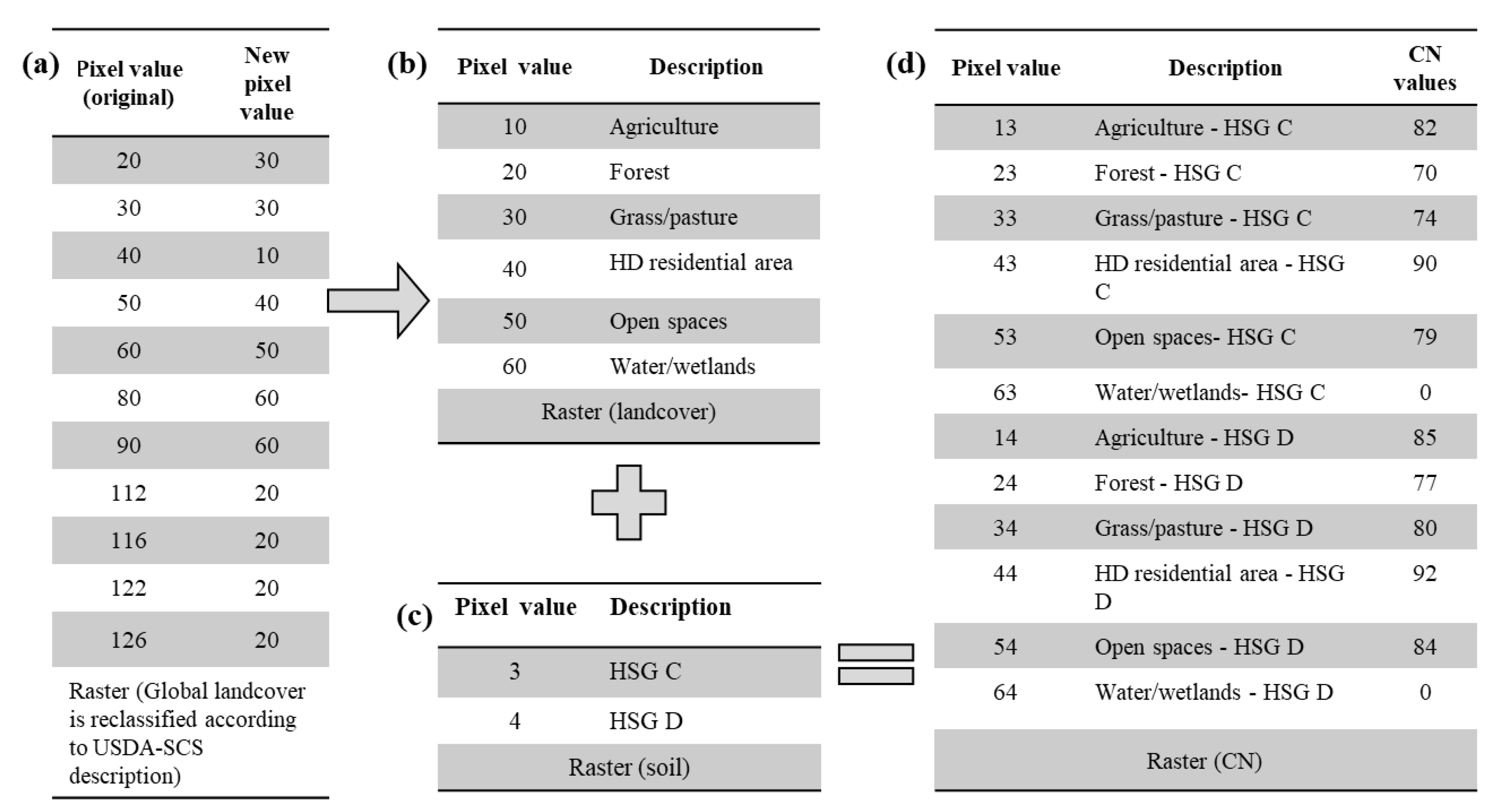
The CN factor was estimated based on landcover information and hydrologic soil group described in Table 2 and Table 3, respectively. The study used the HYSOGs250m [30], a gridded dataset of hydrologic soil groups (HSGs) with approximately 250-m projected resolution. Ross et al. [30] derived the HSG classification from the soil textural classes and depth to bedrock of the FAO soilGrids250m system to support USDA-based CN runoff modeling. Based on the dataset, the study area has two standard soils, HSG C and HSG D, corresponding to moderately high and high runoff potential, respectively.
We used the annual global landcover map data from the Copernicus Land Monitoring Service [31]. The global annual landcover maps follow the UN-FAO Land Cover Classification System (LCCS) and contain 23 discrete classes. The updated 2015 classification has slightly higher accuracy in characterizing forest, cropland, and permanent water classes according to Buchhorn et al. [31]. We then clipped and reclassified the 2015 landcover map according to the description provided by the USDA-SCS as shown in Table 2 and assigned the corresponding curve number. Figure 4 shows the raster analysis process towards the creation of CN values.
The information on the catchment area is needed to compute the discharge or flow rate at each site. The individual catchments were delineated using the identified sites as outlets within the SWATwatershed delineator. The catchment boundary and area, A i in square meters, were computed. The catchment boundary was input to the Zonal Statistics of ArcGIS Spatial Analyst, which extracted the mean q ¯ i   raster values (in meters) within each catchment. We get twelve values (one for each month) of q ¯ i   for each site. The discharge at each site, Q i in m3/s, is computed using (4) where t m is the number of seconds in a month.
Q i = q i ¯ A i / t m
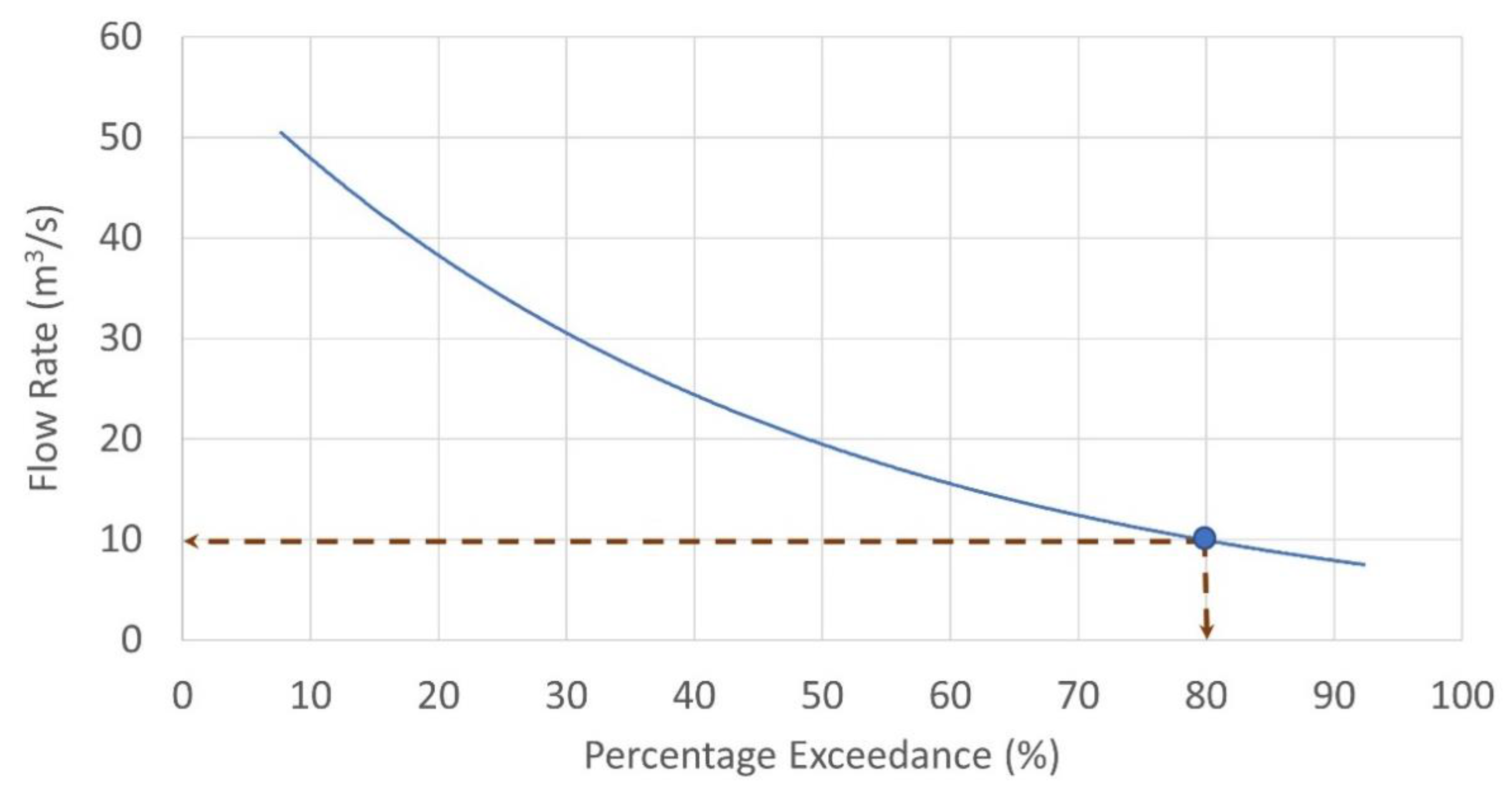
We used the 80% dependable flow value, the value used by NWRB-DENR [40] in its technical evaluation for hydropower projects. To get the 80% dependable flow, we constructed the flow duration curves (FDC) using the CN-estimated monthly runoff values for each potential site. With FDC, the monthly flow values were arranged in descending order, assigned the corresponding rank of 1 to 12 (1 for the highest monthly flow, 12 for the lowest flow), and computed the probability of flow exceedance using the equation,
p = 100   ( M / ( n   +   1 ) ) ,  
where p , M , and n refer to the probability of exceedance (in percentage), discharge rank, and the number of events in a period, respectively. An example of a flow duration curve is shown in Figure 5.
We examined the actual flow record from an existing hydropower plant, the Loboc Hydroelectric Plant (LHEP), and the CN-estimated runoff. With the available data, we found no common years between the actual flow and the CN-estimated runoff. The flow data at LHEP spanned between 2005 to 2019. On the other hand, the CN-estimated runoff used a gridded precipitation dataset from the work of [32] based on precipitation records between 1970–2000. The different record years constrained us from comparing the actual and estimated runoff. In this case, the average patterns of the CN-estimated runoff and the local inflow data were presented instead.

2.4. Hydropower Capacity and Annual Energy Generation

The hydropower capacity, P i   (kW), is computed using the equation,
P i = η   γ   H n e t , i   Q 80 n e t , i
where η is the efficiency at 0.85 [41], γ (kN/m3) is the specific weight of water equal to 9.810, H n e t , i (m) is the net hydraulic head equivalent to 90% of the elevation head where 10% is allotted for frictional losses along the penstock, and Q 80 n e t , i (m3/s) is the net flow equivalent to 90% of the flow at 80% probability of exceedance where 10% returned to the waterway as environmental flow following the Philippines—National Water Resources Board Resolution No. 030613 [40] on the granting of water rights over surface water for hydropower projects. The sites’ computed hydropower values were then classified according to Table 4.
The annual energy generation E i at each potential site is computed using (7) where C F is the minimum capacity factor set at 33.73%, as considered by the Bohol Island Power Development Plan (BIPDP) [4], and T is 8760 h.
E i = P i     C F     T

2.5. River Profile Analysis

The topographic profile of a river system holds useful information of climatic and tectonic forcing across a landscape [43]. A river profile analysis demarcates locations of tectonic activity in tectonically active landscapes [44]. The study examined two geomorphometric indices: the knickpoints and the river steepness index.
The stream power model is widely used to describe the evolution of a river profile, e.g., [45,46], expressed as:
z / t = U   ( x , t ) E   ( x , t )
where z / t is the change in elevation z {L} of a point in the channel that varies with time t {T} and distance x {L}, U {LT−1} is the rock uplift rate, and E {LT−1} is the river incision rate. At steady state, z / t = 0, indicating a balance between rock uplift and erosion. Rearranging Equation (8) and solving for S gives:
U = E = K A m S n
S = ( U / ( K   A m ) ) 1 / n
S = k s A θ
where Equation (9) defines the channel incision rate E [45] as proportional to the erodibility K {T−1L(1−2m)}, local slope S {L/L} and catchment area A {L2}, and m and n are constants. Equation (10) describes a positive correlation between channel gradient and rock uplift rates [43] and assumes that river profiles developed over areas with similar climate, lithology and uplift rates uplift [47]. The terms k s and θ in Equation (11) refer to river steepness and concavity index, respectively, and where k s = ( U / K ) 1 / n and θ = m / n . Equation (11) expresses a power relation between S and drainage area A . A regression analysis of log ( S ) versus log ( A ) gives the concavity index value, which usually ranged between 0.35–0.6 for tectonically active mountains and 0.3–0.6 under normal conditions. A reference concavity index, θ r e f , is introduced to remove the effect of different catchment areas [43,47] and to determine the normalized river steepness index, k s n , as:
k s n = S / A θ r e f
where θ r e f varies between 0.35 to 0.65. k s n and K are dimensional coefficients whose dimensions depend on the value of θ and the value of m [47]. The factor k s is equivalent to M χ [47], also called the river steepness index, which is the slope of the integral solution to the stream power model, when the reference area, A 0 , in Equation (13), is equal to one:
M χ = ( E / K   A o m ) 1 / n
M χ is also used to demarcate regions with rapid rock uplift in tectonic geomorphology [22]. A study by Schwanghart et al. [22] evaluated M χ with peak ground acceleration in the Himalayan regions after the 2015 Gorka earthquake and established that earthquake-triggered landslide damages to hydropower plants clustered in areas where M χ is high. The current study used Topotoolbox to analyze k s n of stream profiles to illustrate quantitatively the channel morphology and provide insights into the spatial dynamics of deformation along river channels [48] and adopted a commonly used θ value of 0.45.
Knickpoints are manifestations of perturbations along river channels [44]. In addition, knickpoints are indicators of landscape disequilibrium significant in engineering structures [23]. In TopoToolbox, [28] located knickpoints using the ‘knickpointfinder’ function that extracts sharp convex sections in the river profile.
In our study, we used both the k s n and the knickpoints to determine the level of risk associated with potential slope failures that may affect the structural stability of hydropower systems. We used TopoToolbox [28] to extract k s n and the knickpoints from a digital elevation model and did further analysis and visualization in a GIS platform. The study classified the k s n (in m0.9) values into five levels of risk using the natural breaks method as follows: 5—very low (<19 m0.9), 4—low (19–59 m0.9), 3—medium (59–131 m0.9), 2—high (131–298 m0.9), and 1—very high (>298 m0.9). Then, we overlaid the identified knickpoints on k s n , and rendered to each knickpoint the corresponding risk level class of the matching k s n .
To identify the risk level associated with each potential site, we drew a 200-m radius buffer region around each site and determined the presence of a knickpoint within the buffer. When two or more knickpoints were present within the buffer, we attributed the highest level of risk for the site.

2.6. Land Use and Population Analysis

National parks and equivalent reserves are ‘valuable for economic and scientific reasons and as areas for the future preservation of fauna and flora’ [49,50]. In the Philippines, renewable energy projects may be allowed within the protected area and located outside the strict protection zones [50] (Sec. 13). The protected areas were obtained from the World Database on Protected Areas (WDPA), downloaded from www.protectedplanet.net (accessed on 13 October 2021), and the Protected Areas Database of the Regional Office 7 of the Department of Environment and Natural Resources. The protected areas within the study area were clipped and overlaid on the identified potential sites. The available protected area dataset has no information on different zones, specifically on strict protection zones. In this case, all protected areas were considered as strict protection zones, and all the potential sites found within were excluded from the list.
In evaluating the population that the potential hydropower systems can serve, the 2015 Philippine Census of Population data was used. The population data at the barangay (village) level can be downloaded from the Philippine Statistics Authority (http://psa.gov.ph) (accessed on 5 August 2021). The administrative map at the barangay level was obtained from a GIS data repository PhilGIS (http://philgis.org) (accessed on 8 August 2021), and the maps’ area attribute was used to compute the population density. Next, the number of households per unit area was calculated, wherein the average household size of 4.4 in 2015 [51] was utilized. A point vector datum, located at the center of each barangay polygon, represents households per area. Finally, the point vector data were used to interpolate and create a raster of household per area.
The next step was to determine the number of households present in the vicinity of each potential site. In the potential sites layer, we created a 200-m buffer around each site. Then, the layer was overlaid on the household per area raster. The Zonal Analysis of ArcGIS extracted the mean household density within the buffer. The number of households within the 200-m radius was calculated as the product of the mean household density and 12.566 hectares. In this paper, this parameter is called HH200m.
The number of households (required for pico- and micro-hydropower systems only following Table 4) that each potential site could support was estimated using the country’s electricity consumption per capita of 696 kWh in 2014 WorldBank data (https://data.worldbank.org) (accessed on 22 August 2021). Using a capacity factor of 33.73% and the annual number of hours of 8760, a micro-hydropower type with a 5–100 kW capacity can support a community of 5–96 households. In contrast, a pico system (<5 kW) can provide enough electricity to a cluster of fewer than five households. This parameter is referred to as HHsite in this paper. The difference between HH200m and HHsite is then obtained. A zero or a positive value indicates electricity-consuming households that can make hydropower financially viable. In contrast, a negative value indicates that the number of households within the 200-m radius of each site is not enough to make the hydropower system economically feasible.

2.7. Case Study Application in Bohol Island, Central Philippines

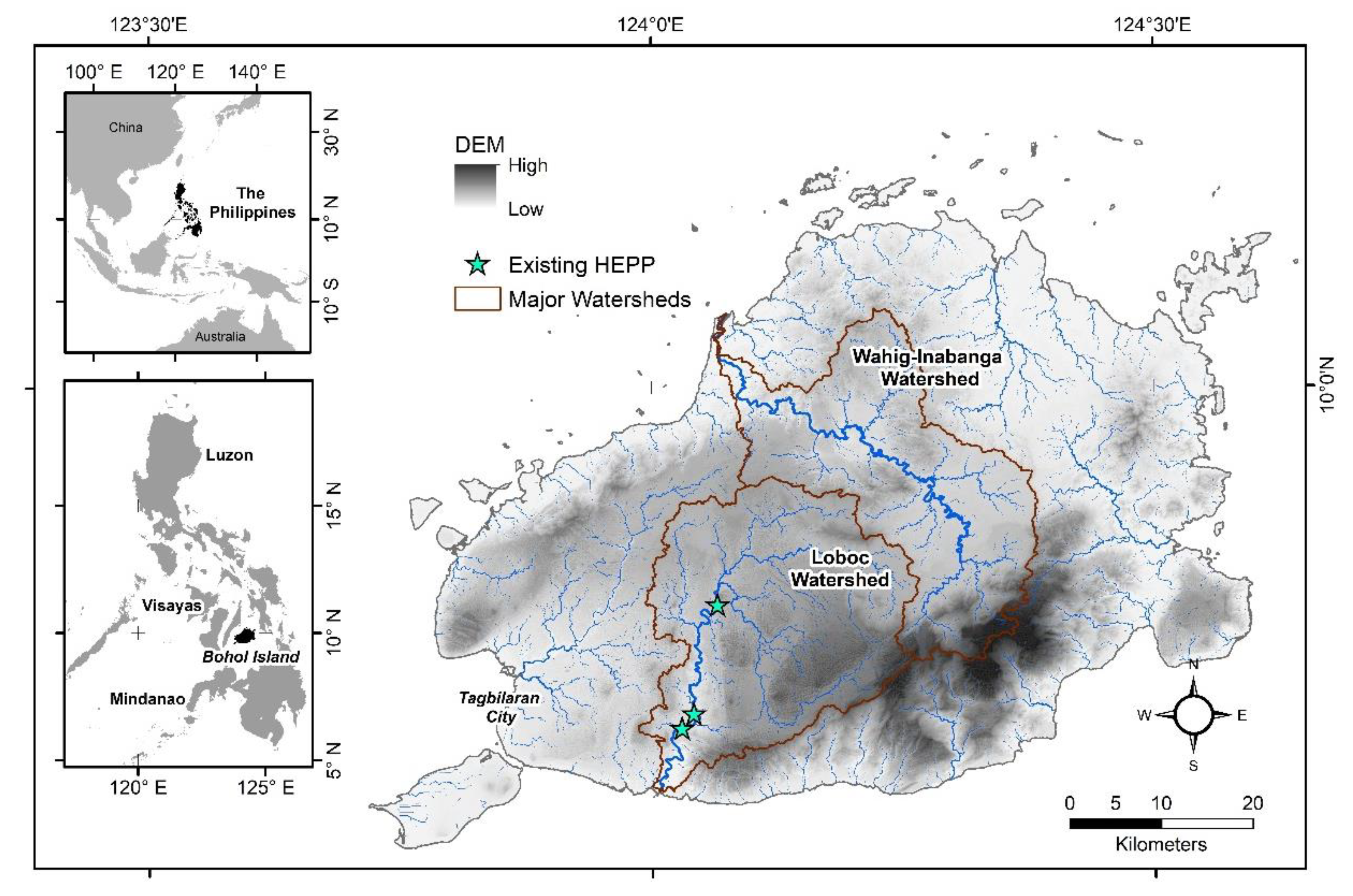
Bohol Island is in the Philippines’ archipelago’s Central Visayas region, as shown in Figure 6. The island province covers roughly 4117 km2 and its highest elevation is at around 833 m (see Figure A2). A 2015 global landcover data has identified more trees with a top density of 30%, dominating the island’s landcover of about 70%, as shown in Appendix A Figure A3. Agriculture and tourism are the primary drivers of the island’s economy.
The island’s climate falls under the 4th type of Corona’s climatic classification having rainfall distributed evenly throughout the year, with distinct dry and wet seasons. The annual precipitation between 2000–2012 observed at Tagbilaran Station ranged from 1210 to 2273 mm. Meanwhile, Appendix A Figure A4 shows the spatial variation of precipitation on the island based on a global climate dataset [32].
Based on the FAO-DSMW (Food and Agriculture Organization—Digitized Soil Map of the World) (WRB-IUSS, 2014), the soils in the island is dominated by three soil types consisting of orthic luvisols, dystric nitosols, and pellic vertisols. The luvisols are soils with clay-enriched subsoil. The nitosols are soil types with significant accumulation of clay (30 percent or more by mass and extending as much as 150 cm below the surface) and a blocky aggregate structure. On the other hand, the vertisols are heavy clay soils with a high proportion of swelling clays. Regarding the hydrologic properties estimated from the global hydrologic soil groupings [52], the soils in the area are described as having moderately high to high runoff potential (See Appendix A Figure A5).
The island has two major watersheds: the Loboc and the Wahig-Inabanga Watersheds. All three existing run-of-river hydroelectric power plants are found in the Loboc Watershed along the main trunk: Sevilla mini HEPP, Loboc mini HEPP (LHEP), and Janopol HEPP (small HEPP) with a combined dependable capacity of 8.7 MW [52]. In 2015, these hydropower plants supplied around 11% of the island’s peak energy demand of 77-MW while the Visayas Grid (Leyte–Bohol Transmission Interconnection) provided most of the island’s energy needs [4].
Natural disasters such as typhoons and earthquakes regularly affect the island. In October 2013, a 7.2 magnitude earthquake destroyed physical infrastructure and cut off the island’s energy supply for a few days to months. In the following month, the super typhoon Yolanda (with international code name Haiyan), although this time spared the island from further destruction, had wrecked the power transmission lines of nearby provinces from where Bohol receives most of its energy supply. Thus, power outages from the earthquake and typhoon interrupted energy-dependent activities and related activities, resulting in significant economic loss.
The unfortunate experience sent an urgent call for the Boholano people to plan and ensure sufficient power supply for the island if a natural catastrophe disengaged the province from the Visayas Grid [4]. To be more resilient to the effects of natural disasters, the government planned to put its energy generation plants in place. Hence, a resource assessment is timely to support the local government exploring potential renewable energy sources for energy self-sufficiency.
The province of Bohol has rich natural resources. While addressing the sustainable development goal of providing clean energy, renewable energy sources could ensure accessibility and availability of the needed energy, especially in rural areas. Rapid resource assessments and feasibility studies on potential hydropower generation sites were critical actions recommended by the Technical Working Group [4] to augment the power supply in the province. The assessment made by Pojadas et al. [42] found that the island’s technical potential for domestic renewable energy resources, from any combination of solar PV, wind, biopower, and hydropower projects, can meet the 35% share of the renewable energy portfolio. On account of these resources and the natural disasters experienced by the island, the study assesses its hydropower potential incorporating landform dynamics following methods discussed previously.

3. Results

3.1. Landscape-Wide Topographic Analysis and the Potential Sites

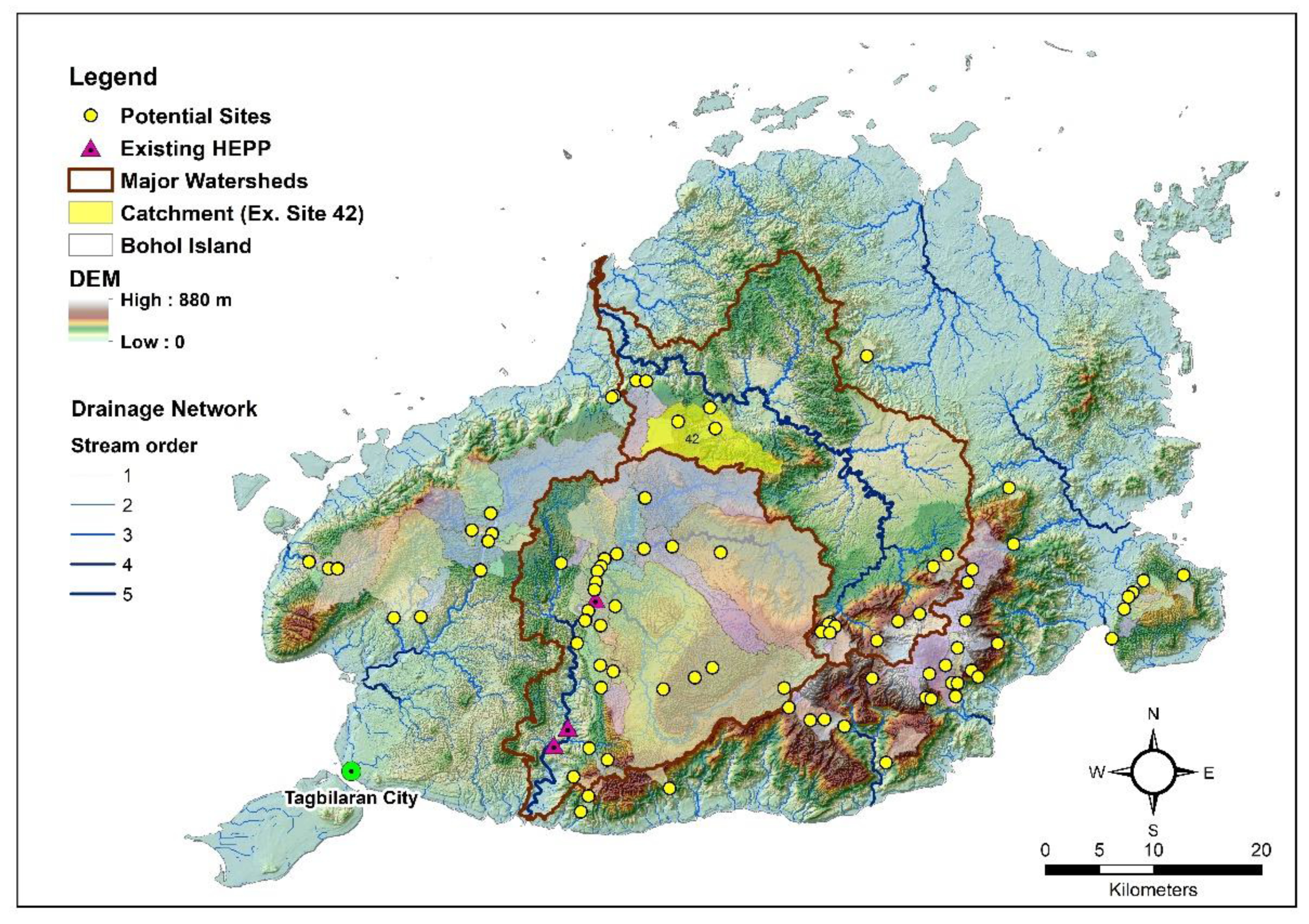
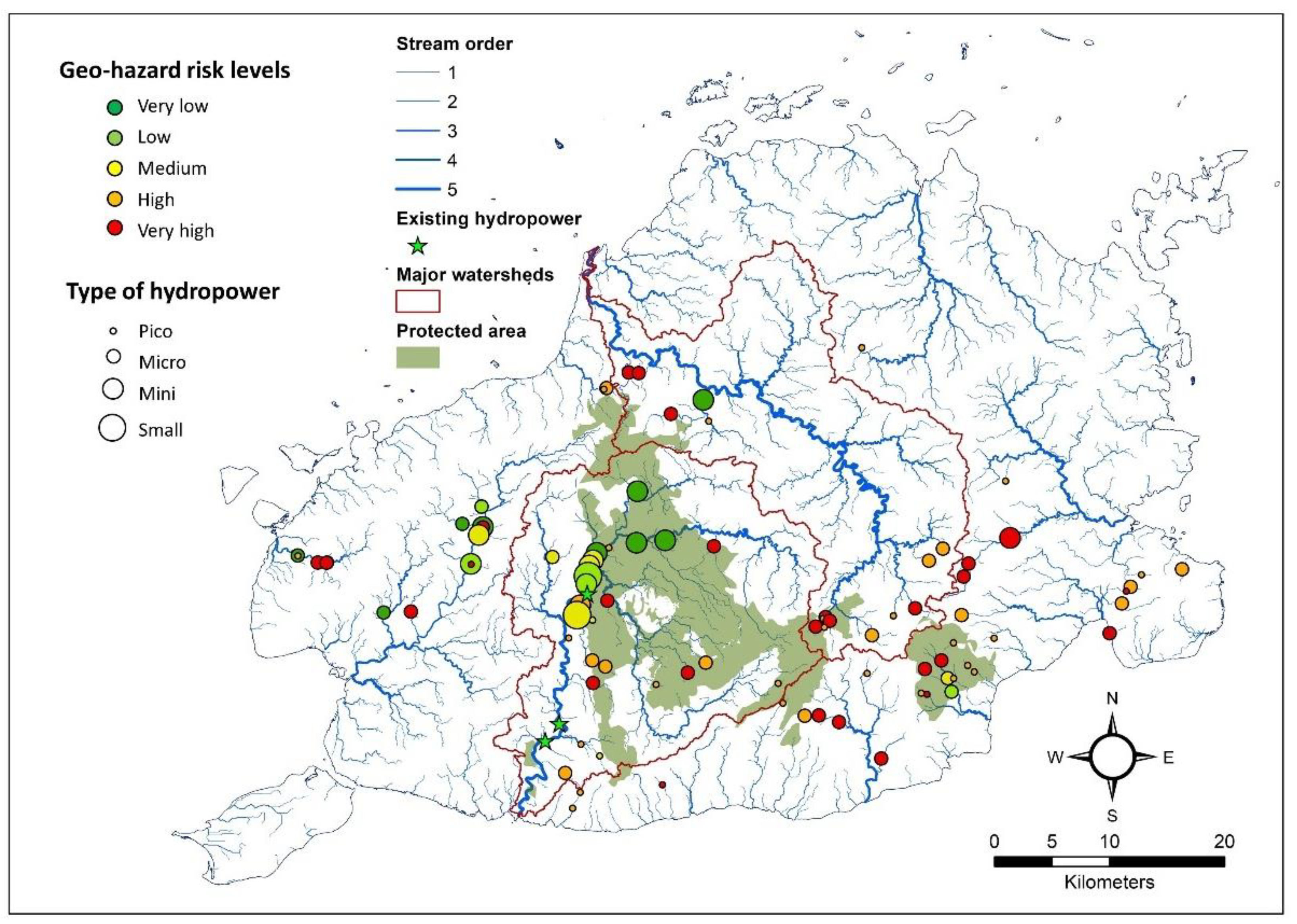
Figure 7 shows the spatial distribution of small-scale hydropower sites identified for an island-wide topographic analysis along with the stream order. The topographic analysis identified 94 potential sites along river channels with a minimum elevation head of 20 m and higher. More than half of the identified sites are found outside of the two major watersheds. There are nine sites located along the main trunk of the Loboc Watershed, which already hosts the three existing hydropower plants. The potential sites are located at distances of more than 500 m from the existing hydropower plants. Other features of each site are given in Appendix B Table A1.
The elevation heads of the identified sites range from 20–62.4 m. Within this range, 71%, 19%, and 10% of the sites have elevation heads between 20–30 m, 30.1–40 m, and >50 m. The sites with elevation heads of 50 m and higher are in the Wahig-Inabanga Watershed (three sites), other watersheds (six sites), and the Loboc Watershed (one site).
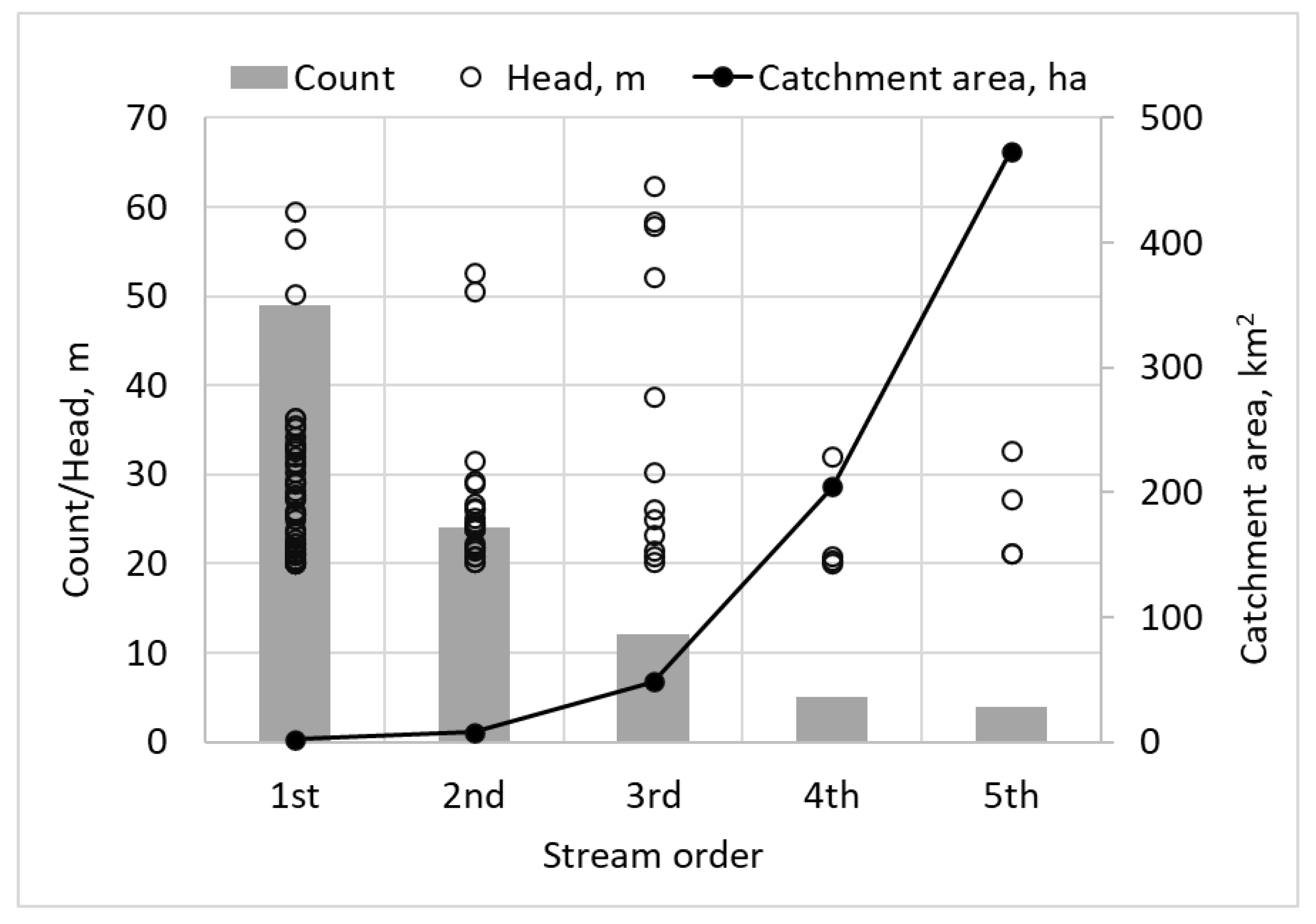
The potential sites fall under different stream orders that vary with elevation heads and catchment areas, as shown in Figure 8. Using Strahler’s stream ordering system, five stream orders are identified in the study area. The longest river, a fifth-order stream, has a total length of 83.3 km but no potential site is found. More than half of the sites (or 52%) are found in the first-order streams, while only four are in the fifth-order streams. The number of potential sites decreases with increasing stream order. A similar trend was found in the study of [16] in the Taw at Umberleigh catchment of South West England where more than half of the detected locations are found in the first-order channels, and the number decreases as the channel order increases. Twelve sites with third-order streams have the highest average elevation head of 36.4 m, while five with fourth-order streams have the lowest average elevation head of 22.8 m. Results indicated no correlation between stream order and elevation head. Four sites found in fifth-order streams have the highest average catchment area of 473 km2, while more than half of the identified sites have first-order streams with an average catchment area of only 2 km2. The sites’ catchment areas increase with stream order.

3.2. Runoff Estimates

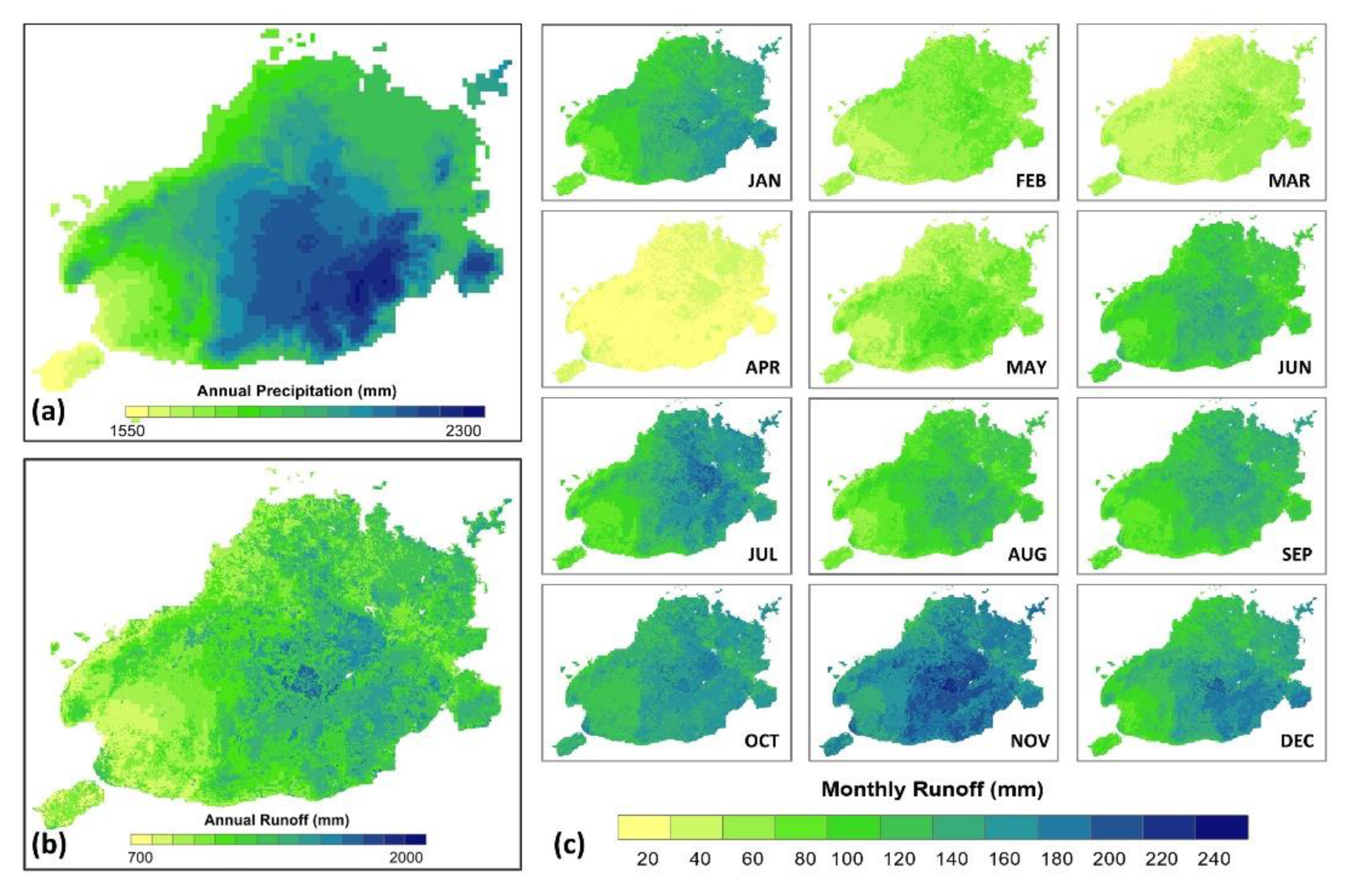
Figure 9 shows the spatial variation of the annual and monthly runoff in the study area, including the annual precipitation. Based on a global dataset [32], the mean annual precipitation varies from 1537 mm to 2263 mm, with the westernmost coast as the driest part and the high-altitude southern portion as the wettest part of the island. The average annual runoff depth varies across the landscape from 657 mm to 1941 mm, or 43% to 87% of the annual precipitation becomes runoff, increasing from the east towards the interior part of the island. The monthly variation of runoff indicates April as the driest month, while November is the wettest month.
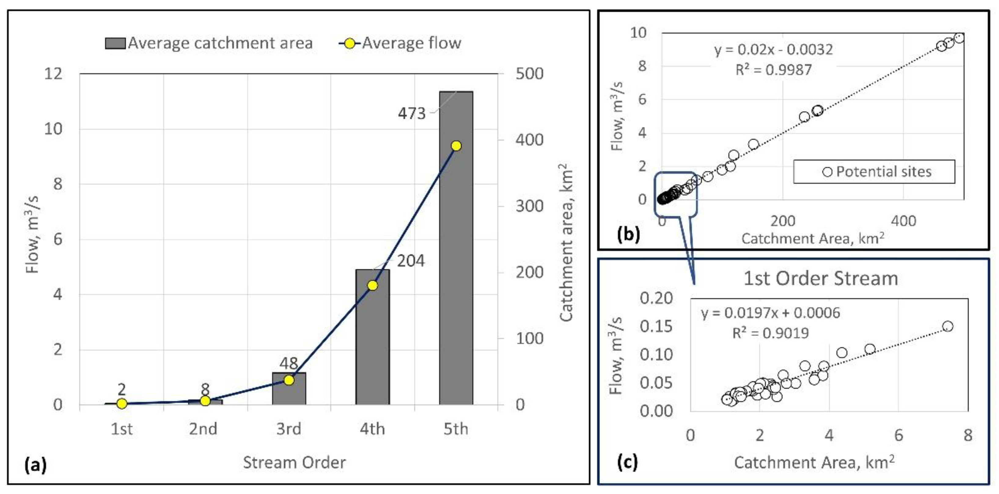
Figure 10 shows the relationship among flow estimates, catchment area, and stream order. The average catchment area and the average flow estimates increase with increasing stream order (Figure 10a). Earlier, Figure 8 shows fewer potential sites are identified in higher order streams, and more than half are in the first-order stream. Zooming in on the flows under the first-order stream, we found flow increasing linearly with the catchment area (Figure 10b). However, in Figure 10c, several potential sites concentrated at the bottom left side of the graph and depicts a reduced linear relationship between the catchment area and flows compared to the general relationship using all the potential sites in this stream order.
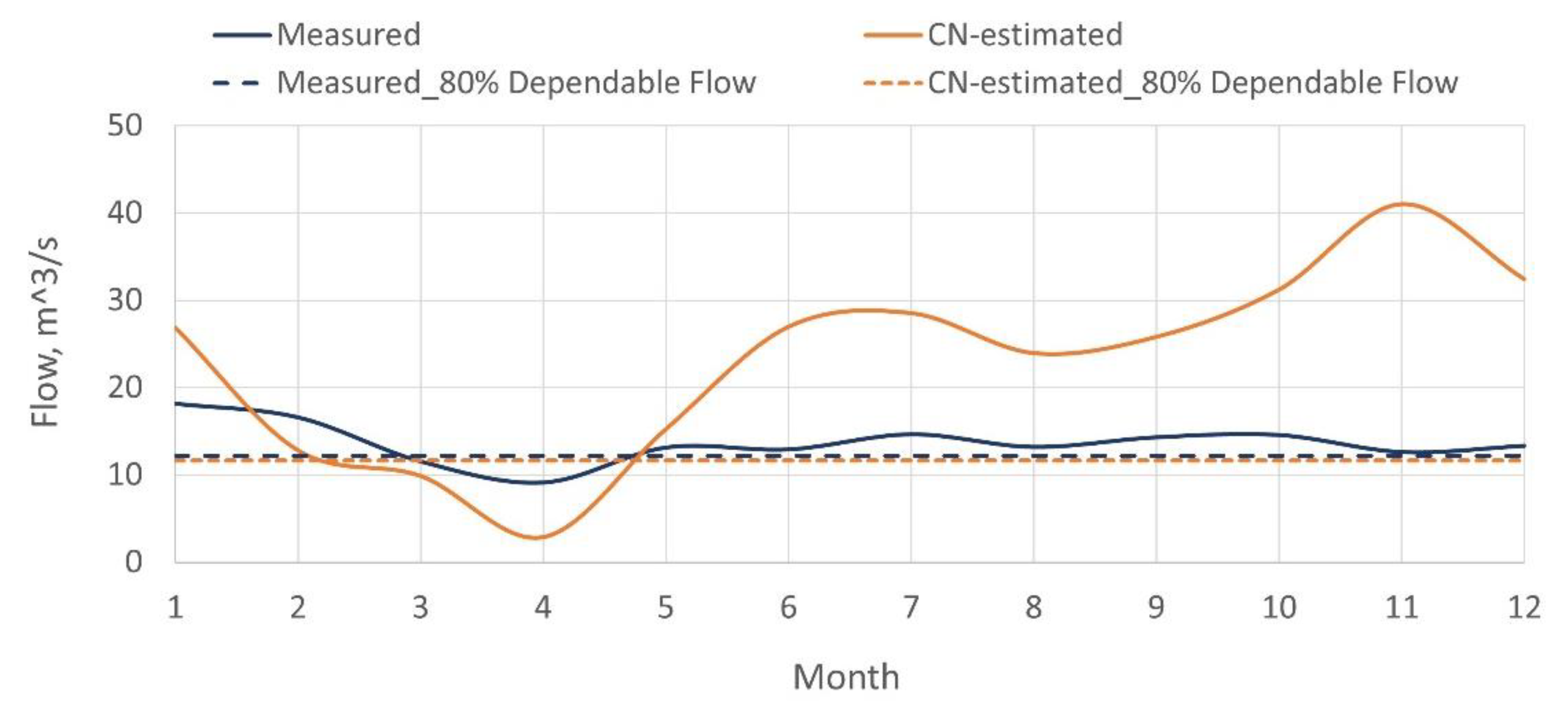
The observed flow data and the estimated runoff using the CN method at the LHEP station, both expressed in mean daily values, are shown in Figure 11. Though both flow datasets show the lowest daily runoff in April, the month with the highest daily flow was November based on CN method estimates. With the actual flow observation, the highest flow was recorded in January. The two runoff curves are showing different patterns: the CN estimated flow shows a more erratic annual pattern with a minimum, maximum and average values of 2 m3/s, 33 m3/s, and 19 m3/s, respectively, while the observed flow at LHEP is smoother with the minimum, maximum, and average flows of 9 m3/s, 18 m3/s, and 14 m3/s, respectively. However, considering the annual 80% dependable flow for a year, the CN flow estimate is lower by 0.56 m3/s.

3.3. Potential Power and Energy Generation

Table 5 summarizes the potential sites’ count, power, and energy generation for each watershed. Section 3.1 presents the distribution of sites per watershed. The power capacity and energy generation are highest in Loboc Watershed, with 75% of the total. It is followed by 21% from other watersheds and 4% from the Wahig-Inabanga Watershed. All the four small types are found in the Loboc Watershed, which has a total power capacity of 6.5 MW accounting for 48% of the total power. Most of the sites are found in smaller watersheds, with 5 mini and 39 micro types having a total power capacity of 2831 MW accounting for 21% of the total power capacity. Although the Wahig-Inabanga Watershed is the second-largest catchment, only a few potential sites are found in the watershed with smaller power capacities.
The number of potential sites in the study area is dominated by micro types followed by pico, mini, and small types, having 69%, 14%, 13%, and 4% of the total count. Although the micro types lead in terms of number, they only contribute 10% to the total annual energy generation since each site can generate around 62 MWh on average. In terms of total power capacity per type, the major contribution comes from four small types contributing 48%, while 12 mini types share 42% of the total power capacity.

3.4. Geo-Hazard Risks Associated with Each Potential Sites

Table 6 shows the classification of the potential sites according to geo-hazard risk level, while Figure 12 depicts the spatial distribution and the associated risk. Potential sites with ‘high to very high’ risk levels comprise 74% (70 out of 94 sites), supplying 18% of the total potential power. Most of the micro types are found under this risk level, with 55 out of 65 micro sites. Meanwhile, the sites with ‘low to very low’ risk levels are 16% of the total sites and contribute 52% of the total potential power. There are nine sites with ‘medium’ risk levels which provide about a third of the total potential power. On the other hand, a quarter of the total potential power comes from two small types in low-risk areas.
The map in Figure 12 shows the spatial distribution of the 94 potential sites, the type indicated by the size of each bubble, and the associated risk level indicated by the color. In the Loboc Watershed, there are 17 sites exposed to ‘high to very high’ risk levels that contribute 12% to the total power capacity, including a small type with a capacity of 1.341 MW. The other three small types found inside the watershed are under ‘low to medium’ risk levels with an aggregate capacity of 5.143 MW. Inside the Wahig-Inabanga Watershed, 14 of the 15 sites are under ‘high to very high’ risk levels. One mini type, located downstream of the watershed, is classified under ‘very low’ risk level. The remaining 50 sites located outside of these 2 watersheds are under different risk levels. There are 21 and 18 sites with ‘high’ and ‘very high’ risk levels, respectively, where 32 sites are micro types.

3.5. Land-Use and Population Constraints

The protected areas in the study area’s mainland, depicted in Figure 12, cover 35,016 hectares as promulgated by the Philippine Law [50]. The same legal instrument indicated that hydropower projects within protected areas are allowed but preferably outside of the strict protection zones and upon the approval of authorized agencies. However, the available dataset does not specify the specific zones within the protected areas, especially the strict protection zones. With this limitation, the study assumed that the protected areas are the strict protection zones and, hence, excluded all potential sites found inside the protected areas.
There are 35 potential sites inside the protected areas, accounting for 37% of the total sites and 53% of the total potential power capacity. Of the 35 sites, 22 are micro types with an aggregate power capacity of only 402 kW. Inside the protected areas are found two small and seven mini types, which account for 50% of the total power capacity, and one of the existing hydropower plants.
The population analysis targets the pico and micro types. Due to the limited capacities of these hydropower types, certain household number should be present in the vicinity of the site to minimize the cost of putting up transmission lines [53]. The household analysis found 27 sites fail to show the required household number within a 200-m radius. Hence, there are 25 potential sites left after land-use and population constraint analysis. The remaining power capacity is now reduced to 40% of the total. Six sites inside the Loboc Watershed provide 58% of the remaining power capacity. A total of 64% of the remaining sites are found outside the two major watersheds with 36% power capacity. In contrast, the three sites inside Wahig-Inabanga Watershed contribute only 7% of the power capacity.

4. Discussion

The hydropower potential of a landscape is driven by the dynamics of its topography and hydrology: topography provides the hydraulic head while the hydrology provides the discharge rate information. Characterizing these features of the landscape will help us to understand the potential of the available resource [54] particularly for hydropower generation. Such landscape characterization also enables the identification of geo-hazard risks associated with each site enabling the development of location-specific engineering designs or the prioritization of sites for further development [23]. The dynamics of a landscape is also, in one way or another, impacted by anthropogenic influences which can further restrict potential resource use in favor of environmental concerns as well as economic considerations.

4.1. Loboc Watershed Hydropower Potential and Environmental Concerns

Most of the hydropower potential in the island landscape of Bohol, Philippines, can be harnessed within the Loboc Watershed. About three-fourths of the estimated hydropower (or 10.2 MW) can be generated from the sites identified inside the watershed, mainly along the main trunk where the three existing hydropower systems are found. The nine potential sites found in the Loboc River can possibly augment the three existing hydropower plants currently having a total installed capacity of 8.7 MW [4]. Tamm and Tamm [20] also found new suitable sites along Estonian rivers where hydropower has been or is currently harvested. However, the identified potential sites suggest a series of small-scale hydropower projects. In this kind of arrangement, Mayor et al. [9] cautioned that such systems would result in a “cumulative environmental impact cascading along the river system”. Their study suggested reducing the number of low-capacity systems with less significance to the final energy generation and optimizing the use of existing hydropower infrastructure by integrating pumping and storage technologies.
The Loboc Watershed is also an area of high biodiversity value where 40% of its land area is declared protected (see Appendix A Figure A5). About 77% of the protected areas in the mainland of Bohol are inside the watershed covering the Loboc Watershed Forest Reserve and the Chocolate Hills Natural Monument [49,50]. Section 13 of Ref. [50] restricted renewable energy projects within strict protection zones of the protected areas. However, as of the conduct of the study, data defining the strict zones inside the protected areas were not available. Given the situation, we applied the restrictions inside the whole protected areas, similar to a study of [16], and found only two of the nine sites on the main Loboc River to be developable. In the study of Sammartano et al. [16] in the Taw at Umberleigh catchment (South West England) all sites within protected areas were excluded due to environmental and economic issues. The UK Environment Agency required potential sites located within protected areas to secure permits and only the sites with well-designed measures preventing negative impacts may be allowed [16]. Integrating the best measures to ensure environmental integrity will entail higher investment cost to realize a hydropower plant [16].

4.2. Potential Sites Outside of Major Watersheds

The topographic analysis using a DEM, which covers the whole landscape, has identified more than half of the total potential sites outside the two major watersheds in the study area. These potential sites dispersed across the study area present an opportunity for remote areas to harvest hydropower, take advantage of the available resource, and provide power to small communities and small-agro industries, as documented in several studies [53,55]. The study results provide a new perspective on assessing a landscape for potential small-scale hydropower sites to encompass all watersheds irrespective of scale. In the initial assessment of an area for potential hydropower site exploration, such an approach is critical, giving insights into the overall hydropower potential of an island landscape. Further work to improve on this new approach, including the validation of the identified sites (ex. [16,20]), is suggested in future studies.

4.3. Small-Scale Hydropower Potential in the Island Landscape

The results of power capacity analysis showed that harnessing the hydro-based renewable energy sources in the study area will comprise several small-scale units distributed throughout the main island. However, there are contrasting feedbacks on the deployment of many small-scale hydropower systems due to environmental impacts and other issues (e.g., [9,53]). But for the Italian case where large-scale systems were already developed and suitable sites were already utilized, it was emphasized that increasing hydropower contribution could come from small-scale systems [56]. Moreover, many of the small-scale hydropower systems benefit rural development [8,53,55]. The advantages of these systems to rural areas in developing countries include improvement in productivity, women empowerment through energizing small agro-industries, and the notable little environmental impact. On a side note, small-scale hydropower systems are also challenged with high initial costs [55], but such can be counteracted by little operation and maintenance costs.
Notably, the study limits the potential sites to a minimum elevation head of 20 m. Future studies may consider a lower elevation head (<20 m) to identify potential hydropower sites. The global hydropower assessment of Hoes et al. [2] sets a minimum elevation head of 1 m but limits the river discharge to 0.1 m3/s to deliver the smallest hydropower plant capacity of 1 kW, while the study of Arthur et al. [35] considers 10 m as the minimum head in its final selection of hydropower sites.

4.4. Dataset Limitations

One of the challenges in resource assessment for many developing countries is the limited historical climate datasets, flow data, updated landcover, and soil hydrologic properties of a target landscape [13,57]). The study demonstrated the use of global datasets to estimate runoff from hydrologic soil group data, gridded precipitation data, and landcover datasets in the initial assessment phase. Several similar studies used global datasets such as the FAO digital soil map of the world to carry their analysis (ex. [35]). However, the study results still call for localized data to validate the estimated runoff and establish the efficiency of the CN method in estimating runoff for the target landscape. Furthermore, it would also be interesting to use physically based hydrologic models such as the studies of [16,18,35,58] to improve understanding of the hydrology of the study area. Further fieldwork such as those conducted by [16] is necessary to validate the results.

4.5. Geometric Index of Geo-Hazard Risk

The river profile analysis from a digital elevation model was employed to quantify the geo-hazard risk level associated with each potential site, using the geometric index k s n and knickpoints. The analysis gave insights on tectonically active areas in the landscape as manifested by the river channels’ high river steepness index and presence of knickpoints, thus indicating the landscape’s vulnerability to tectonic activity. A positive correlation of k s n with uplift rates, and the arrangement of knickpoints are indications that a landscape is temporarily reacting to regional uplift along the subduction zone as what Boulton et al. [26] found in the Makira, Solomon Islands. Further, the study [26] suggested that the formation and propagation of knickpoints was generated by an increase in uplift rates and the associated base-level fall. A study by [22] found severe damages to hydropower projects as primarily caused by earthquake-triggered landslides in the Himalayan region during the 2015 Nepal’s Gorkha earthquake, and also revealed the landslides clustered in areas with high values for river steepness index and ground peak acceleration. Upon evaluation using seismic hazard and river steepness, the study [22] predicted most of the Himalayan rivers were unsuitable for hydropower projects. In their study, it was emphasized that hazard assessment for hydropower projects must consider both seismic and geomorphic settings of potential sites. Landform dynamics indicated by geomorphic indices, proxies of tectonic and climatic processes, are crucial for engineering structures that sit on transient landscapes as emphasized in the study of Geach et al. [23] Channel stability, according Schwanghart et al. [22], is a primary concern where hydropower structures are usually situated along or adjacent to ‘steep river channels and towering sidewalls’ that are disposed to become unstable during strong seismic activity.
The integration of geomorphic indices in the initial assessment of land resources for small-scale hydropower sites allow for classifying potential sites according to geology-related hazards. The classification maybe a useful tool to assist decision-makers and project developers to prioritize potential sites for further development. The study by Geach et al. [23] produced a geohazard constraint map showing ground related hazard. The maps are expected to provide guidance to the project crew in conducting field investigations, designing location-specific construction methodologies and in addressing ground limitations [23].
The current study, however, is limited to two geometric indices only. Future work may consider other metrics of surface and geology-related processes relevant to hydro-related structures such as those in the studies of [22,23]. The availability of landslide records in the study area may reinforce the usefulness of the river profile analysis in the initial assessment phase of hydropower development.

4.6. Land-Use Policy and Population Density as Constraints

Land-use classifications posed limitations to hydropower projects as promulgated by legal instruments. Existing land-use policy limits hydropower projects within ‘strict zones’ of protected areas [59]. Due to limited information on the zoning within declared protected areas, the study has considered the whole protected areas as strict zones, removing several potential sites. Meanwhile, the presence of end-users near potential sites is an indicator of project economic feasibility, specifically for micro and pico hydropower types. For these types, a minimum number of households that clusters near a potential site is a requirement to keep the cost of transmission low [3,53].
The constraint analysis, examining land use and population, has significantly reduced the number of potential sites by 73% and consequently the potential hydropower capacity by 60%. However, these two issues can be viewed as temporary constraints and are expected to change in the future. With the country’s increasing population, there is a tendency that areas devoid of communities may later be encroached with clusters of households that need hydro-based energy sources to support their economic activities, turning the identified potential sites to be more economically viable. On the other hand, planning authorities may soon refine and precisely define zones under strict use within the protected areas. Once this happens, potential sites located in the protected areas but not in strict zones can be developed, thus, optimizing the hydropower potential found in the landscape.
As the economy develops, the demand for more energy to drive economic activities increases. It has been shown that energy generation significantly contributes to global warming and environmental impacts [6,7]. One way forward is to explore for lesser impacts and shift towards renewable energy sources, integral for a sustainable future. In many developing countries where land and water resources are available, the exploitation of hydropower sources is an attractive prospect [3,7]. Such systems offer less impact on the environment than fossil-fueled energy production, but initial investment cost seems high [3,7,35,54]. Knowledge of the possible adverse effects of hydropower and the underlying cost effectiveness are a challenge to future decisions on the scale of new developments. However, small-scale hydropower systems are still an alternative where the large-scale hydropower systems are no longer feasible or are already explored [60]. Other renewable sources such as geothermal, biomass, wind, and solar are other options to explore.

5. Conclusions

The resource assessment for hydropower site identification is usually limited to major watersheds identified in each landscape. A landscape’s topography and hydrology are examined using GIS, terrain analysis tools, and hydrologic models to understand watershed parameters necessary to identify suitable locations and estimate hydropower capacity. Moreover, local datasets needed to carry out the analysis are usually not available or are limited. Advanced tools and the freely available global datasets enable the characterization of landscape dynamics for potential hydropower sites. An equally important factor to consider in the site exploration is the risk to geo-hazard and other surface processes in tectonically active landscape. Further, existing land-use policy in relation to environmental concerns and a population analysis posed as constraints to limit the identified potential sites. We applied the foregoing method in the island landscape of Bohol, the Philippines, and drew the following conclusions:
(a)
The approach employed in the study reveals potential small-scale hydropower sites inside major and small watersheds. More than half of the identified sites are located outside the major watersheds, with a share of about 21% of the total potential power capacity;
(b)
Freely available global datasets are successfully used to estimate runoff using the CN method and found runoff varying spatially and temporally across the landscape and at each potential site;
(c)
The hydropower potential in the study area consists of a range of small-scale hydropower systems with different power and energy generation capacities. In terms of number, the micro types dominate in the study area, but four small types provide almost half of the potential hydropower;
(d)
Each potential site is found under varying levels of geo-hazard risk innate to the geography and geology of the area. Seventy-four percent (74%) of the sites are under ‘high—very high levels’ of geo-hazard risk, while 52% of the total potential power capacity can be produced from low-risk sites;
(e)
The land-use and population analysis found several potential sites inside protected areas and in areas where the number of beneficiaries is still limited. The analysis result reduces the number of sites by 73%, and consequently, power capacity by 60%. Future changes in land-use planning and an increase in population in remote areas are seen to optimize the development of the identified potential sites;
(f)
The study produced decision-support maps showing the potential sites’ spatial distribution, the hydropower types and power capacities, and the risk levels associated with each site. The maps are expected to provide crucial information for resource managers and decision-makers.
In summary, the approach used, and the results presented could be valuable support tools for decision-makers and energy developers in identifying potential sites for small-scale hydropower in the study area during the initial assessment phase of hydropower exploration.

Author Contributions

Conceptualization: I.T., R.E.O., A.T.; Methodology: I.T., R.E.O., A.T.; Analysis, Visualization and Writing—original draft preparation: I.T.; Writing—review and editing: I.T., R.E.O., A.T. All authors have read and agreed to the published version of the manuscript.

Funding

The research is supported by the Philippine Department of Science and Technology—Science Education Institute—Engineering Research Development for Technology (DOST-SEI—ERDT) Scholarship Program.

Informed Consent Statement

Not applicable.

Data Availability Statement

The data used in the study are available through the links provided in the text. All computations are available upon request to the main author.

Acknowledgments

The main author is grateful to the Graduate Scholarship Grant from DOST-ERDT at the School of Engineering—University of San Carlos and the Bohol Island State University—Bilar Campus for the support. The different sources of the local and global datasets used in the study are gratefully acknowledged.

Conflicts of Interest

The authors declare no conflict of interest.

Appendix A

Figure A1. A detailed flow of analysis for the study.
Energies 15 01130 g0a1
Figure A2. A digital elevation dataset of the study area.
Energies 15 01130 g0a2
Figure A3. Details of the landcover in the study area.
Energies 15 01130 g0a3
Figure A4. Temporal and spatial variation of precipitation in the study area.
Energies 15 01130 g0a4
Figure A5. Spatial variation of the hydrologic soil group in the study area.
Energies 15 01130 g0a5

Appendix B

Table A1. List of potential small-scale hydropower sites identified in Bohol Island, Philippines.
CountWatershedCatchment IDArea, haGross Head, mFlow, m3/sPower, kWAnnual Energy, kWhTypeksn ClassHH200mHHsiteHHdiffProtected Area
1Other114820.60.029411,976picohigh4.63.90.7outside
2Wahig-Inabanga Watershed4121124.40.21235103,096microvery high2.833.7−30.9outside
3Wahig-Inabanga Watershed1336035.60.0601442,357microvery high8.213.8−5.6outside
4Other1921931.40.041925,648microhigh4.58.4−3.8outside
5Other2525031.00.026515,853microhigh3.85.2−1.3outside
6Wahig-Inabanga Watershed42486758.40.9023561,050,624minivery low0.00.00.0outside
7Wahig-Inabanga Watershed4571626.70.1272367,614microvery high6.322.1−15.8outside
8Wahig-Inabanga Watershed5311832.00.022514,033picohigh6.04.61.4outside
9Other6011429.30.026515,254microhigh3.65.0−1.4outside
10Loboc Watershed6374820.80.1351955,978microvery high2.818.3−15.5inside
11Loboc Watershed65572220.91.168165488,058minivery low0.00.00.0inside
12Other68164324.80.30351149,926microvery low8.649.0−40.4outside
13Other71175920.20.32244130,025microlow8.642.5−33.9outside
14Other80130331.60.23249146,047microvery low5.547.7−42.2outside
15Other85759862.41.3985891,739,438minivery low0.00.00.0outside
16Other9038259.60.0632575,141microvery high7.324.5−17.2outside
17Other10335656.50.0562162,982microvery high5.520.6−15.1outside
18Other113996552.11.8016341,873,906minimedium0.00.00.0outside
19Other116252657.90.591231682,922minivery high0.00.00.0outside
20Loboc Watershed12511,87632.12.6615761,702,843minivery low0.00.00.0inside
21Loboc Watershed13015,17420.93.3254691,385,436minivery low0.00.00.0inside
22Loboc Watershed13799423.80.2033396,352microvery high7.331.5−24.1inside
23Loboc Watershed13912421.00.02138644picohigh3.92.81.1inside
24Wahig-Inabanga Watershed14127724.40.0651131,791microhigh7.510.4−2.9outside
25Loboc Watershed147189921.50.32747140,209microvery high4.545.8−41.3inside
26Loboc Watershed15023,59420.44.9676832,017,384minivery low0.00.00.0inside
27Other156378723.20.58792272,066microvery low7.888.8−81.0outside
28Other16119227.80.028515,705microhigh7.85.12.7outside
29Loboc Watershed16730429.00.0491028,505micromedium4.39.3−5.0outside
30Loboc Watershed17325,68920.05.3287212,130,974minimedium0.00.00.0inside
31Wahig-Inabanga Watershed17720929.10.0501029,027microhigh6.39.5−3.2outside
32Other195214725.00.34458171,157micromedium7.555.9−48.4outside
33Other19624033.00.039925,362microvery high4.98.3−3.3outside
34Other20184121.90.1241854,179microvery high7.517.7−10.2outside
35Other20976729.30.17935104,667microvery high14.434.2−19.7outside
36Other21711,29530.32.0074111,214,055minilow0.00.00.0outside
37Other22521630.30.031618,508microvery high4.56.0−1.5outside
38Loboc Watershed23325,87220.55.3567402,186,165minimedium0.00.00.0inside
39Other23426721.00.064926,711microhigh5.18.7−3.6outside
40Other23817520.00.036514,370picohigh11.14.76.4outside
41Loboc Watershed24646,27932.79.21020316,001,996smalllow0.00.00.0inside
42Other24963121.40.1472162,926microvery high19.320.5−1.3outside
43Loboc Watershed25146,34221.29.22013223,905,939smalllow0.00.00.0inside
44Other27118132.70.037823,857microhigh9.37.81.5outside
45Other28412834.30.028719,427microvery high11.06.34.6outside
46Loboc Watershed30074129.10.1502987,155microvery high3.328.5−25.2inside
47Other31543625.70.1031852,956microhigh9.317.3−8.0outside
48Loboc Watershed31947,49121.19.40713413,962,478smallhigh0.00.00.0outside
49Wahig-Inabanga Watershed33339452.70.0913295,171microvery high9.631.1−21.5outside
50Other34671825.20.0901545,323microvery high9.214.8−5.6outside
51Other348423120.30.67793273,575microvery low9.389.3−80.0outside
52Loboc Watershed357139950.60.25086252,673microvery high5.682.5−76.9outside
53Other36418227.40.043823,702microhigh7.57.7−0.3outside
54Loboc Watershed36549,22627.39.70917905,288,296smallmedium0.00.00.0outside
55Wahig-Inabanga Watershed38010527.20.021411,416picohigh4.73.71.0outside
56Wahig-Inabanga Watershed40351736.40.1102779,789microvery high7.026.1−19.0inside
57Wahig-Inabanga Watershed40917720.30.039515,693microhigh6.25.11.0inside
58Loboc Watershed41821422.30.039617,460micromedium2.65.7−3.1inside
59Wahig-Inabanga Watershed43050829.00.1092163,166microvery high5.820.6−14.9inside
60Wahig-Inabanga Watershed44614250.30.0321131,997microvery high3.710.4−6.8inside
61Wahig-Inabanga Watershed45713823.90.030514,222picohigh2.34.6−2.4outside
62Other46223128.20.049927,272microvery high14.98.96.0outside
63Wahig-Inabanga Watershed46838420.10.0801131,940microhigh3.510.4−7.0outside
64Loboc Watershed47111825.50.01838996picohigh8.12.95.2outside
65Other47518026.00.043822,328microhigh8.67.31.3outside
66Other48013022.70.032514,689picohigh9.24.84.4inside
67Loboc Watershed48242522.00.0811235,507microhigh5.911.6−5.7inside
68Other48333021.20.0801133,869microvery high6.811.1−4.3inside
69Loboc Watershed48923725.70.045822,968microhigh3.37.5−4.2inside
70Other49213321.40.031513,332picohigh13.04.48.6inside
71Loboc Watershed49330620.30.060824,216microhigh6.07.9−1.9inside
72Other49716136.30.035925,632microvery high5.78.4−2.6inside
73Other51021220.10.049719,777microhigh10.96.54.5inside
74Loboc Watershed51727426.30.0551029,070microvery high4.19.5−5.4inside
75Other52213420.00.030411,794picohigh5.03.91.1outside
76Other527193138.80.434114335,958minimedium0.00.00.0inside
77Other53020221.60.049721,022microhigh9.16.92.3inside
78Loboc Watershed53676526.10.1462676,253microvery high4.724.9−20.2inside
79Loboc Watershed54614820.30.033513,350picohigh5.94.41.5inside
80Loboc Watershed54914135.20.030720,722microhigh39.66.832.9inside
81Other557220126.20.49487258,118microlow12.884.3−71.4inside
82Other56213027.70.031617,264microhigh7.95.62.3inside
83Other56714325.00.034616,776microvery high8.95.53.4inside
84Other57613833.10.027617,661microhigh6.05.80.3outside
85Other58250224.20.0971646,588microvery high4.715.2−10.5outside
86Other58829321.90.055824,201microhigh5.87.9−2.1outside
87Other58995820.90.1862677,659microvery high4.225.4−21.2outside
88Loboc Watershed59214621.90.026411,349picohigh7.93.74.2outside
89Loboc Watershed59519622.20.041618,114micromedium6.65.90.7outside
90Other59855523.80.1282160,815microvery high8.819.9−11.1outside
91Loboc Watershed60223733.50.0431028,374microhigh25.89.316.5outside
92Other60824523.50.042719,643microvery high7.86.41.4outside
93Other61610622.30.02039042picohigh13.23.010.3outside
94Other61827720.30.049719,875microhigh17.86.511.3outside

References

  1. Avtar, R.; Sahu, N.; Aggarwal, A.K.; Chakraborty, S.; Kharrazi, A.; Yunus, A.P.; Dou, J.; Kurniawan, T.A. Exploring Renewable Energy Resources Using Remote Sensing and GIS—A Review. Resources 2019, 8, 149. [Google Scholar] [CrossRef] [Green Version]
  2. Hoes, O.A.C.; Meijer, L.J.J.; van der Ent, R.J.; van De, N.C. Systematic high-resolution assessment of global hydropower potential. PLoS ONE 2017, 12, e0171844. [Google Scholar] [CrossRef]
  3. JICA. Guideline and Manual for Hydropower Development Vol 2 Small Scale Hydropower. 2011. Available online: https://openjicareport.jica.go.jp/pdf/12024899.pdf (accessed on 3 July 2020).
  4. Province of Bohol. Bohol Island Power Development Plan (BIPDP). 2017. Available online: http://www.ppdobohol.lgu.ph/plan-reports/development-plans/bohol-island-power-development-plan-bipdp/ (accessed on 21 May 2020).
  5. Yi, C.S.; Lee, J.H.; Shim, M.P. Site location analysis for small hydropower using geo-spatial information system. Renew. Energy 2010, 35, 852–861. [Google Scholar] [CrossRef]
  6. Zhang, J.; Xu, L.; Li, X. Review on the externalities of hydropower: A comparison between large and small hydropower projects in Tibet based on the CO2 equivalent. Renew. Sustain. Energy Rev. 2015, 50, 176–185. [Google Scholar] [CrossRef]
  7. IRENA. Renewables Readiness Assessment: The Philippines. Int. Renew. Energy Agency 2017, 10, 79–89. Available online: https://www.irena.org/publications/2017/Mar/Renewables-Readiness-Assessment-The-Philippines (accessed on 20 June 2021).
  8. Faruqui, N.I. Small hydro for rural development. Can. Water Resour. J. 1994, 19, 227–235. [Google Scholar] [CrossRef] [Green Version]
  9. Mayor, B.; Rodríguez-Muñoz, I.; Villarroya, F.; Montero, E.; López-Gunn, E. The role of large and small scale hydropower for energy and water security in the Spanish Duero basin. Sustainability 2017, 9, 1807. [Google Scholar] [CrossRef] [Green Version]
  10. Asian Development Bank. The Philippines: Energy Sector Assessment, Strategy, and Road Map. 2016. Available online: https://www.adb.org/sites/default/files/institutional-document/218286/mya-energy-sector-assessment.pdf (accessed on 5 May 2020).
  11. Philippine Department of Energy. Renewable Energy Decade Report 2008–2018. 2019. Available online: https://www.doe.gov.ph/renewable-energy/empowered-renewable-energy-decade-report-2008-2018?ckattempt=1 (accessed on 12 January 2021).
  12. Fasipe, O.A.; Izinyon, O.C.; Ehiorobo, J.O. Hydropower potential assessment using spatial technology and hydrological modelling in Nigeria river basin. Renew. Energy 2021, 178, 960–976. [Google Scholar] [CrossRef]
  13. Moiz, A.; Kawasaki, A.; Koike, T.; Shrestha, M. A systematic decision support tool for robust hydropower site selection in poorly gauged basins. Appl. Energy 2018, 224, 309–321. [Google Scholar] [CrossRef]
  14. Thin, K.K.; Zin, W.W.; San, Z.M.L.T.; Kawasaki, A.; Moiz, A.; Bhagabati, S.S. Estimation of run-of-river hydropower potential in the myitnge river basin. J. Disaster Res. 2020, 15, 267–276. [Google Scholar] [CrossRef]
  15. Bayazıt, Y.; Bakış, R.; Koç, C. An investigation of small scale hydropower plants using the geographic information system. Renew. Sustain. Energy Rev. 2017, 67, 289–294. [Google Scholar] [CrossRef]
  16. Sammartano, V.; Liuzzo, L.; Freni, G. Identification of potential locations for run-of-river hydropower plants using a GIS-based procedure. Energies 2019, 12, 3446. [Google Scholar] [CrossRef] [Green Version]
  17. Tarife, R.P.; Tahud, A.P.; Gulben, E.J.G.; Macalisang, H.A.R.C.P.; Ignacio, M.T.T. Application of geographic information system (GIS) in hydropower resource assessment: A case study in Misamis Occidental, Philippines. Int. J. Environ. Sci. Dev. 2017, 8, 507–511. [Google Scholar] [CrossRef] [Green Version]
  18. Guiamel, I.A.; Lee, H.S. Potential hydropower estimation for the Mindanao River Basin in the Philippines based on watershed modelling using the soil and water assessment tool. Energy Rep. 2020, 6, 1010–1028. [Google Scholar] [CrossRef]
  19. Jafari, M.; Fazloula, R.; Effati, M.; Jamali, A. Providing a GIS-based framework for Run-Of-River hydropower site selection: A model based on sustainable development energy approach. Civ. Eng. Environ. Syst. 2021, 38, 102–126. [Google Scholar] [CrossRef]
  20. Tamm, O.; Tamm, T. Verification of a robust method for sizing and siting the small hydropower run-of-river plant potential by using GIS. Renew. Energy 2020, 155, 153–159. [Google Scholar] [CrossRef]
  21. Marston, R.A.; Butler, W.D.; Patch, N.L. Geomorphic Hazards. In International Encyclopedia of Geography: People, the Earth, Environment and Technology; John Wiley & Sons, Inc.: Hoboken, NJ, USA, 2017. [Google Scholar]
  22. Schwanghart, W.; Ryan, M.; Korup, O. Topographic and seismic constraints on the vulnerability of Himalayan hydropower. Geophys. Res. Lett. 2018, 45, 8985–8992. [Google Scholar] [CrossRef]
  23. Geach, M.R.; Stokes, M.; Hart, A. The application of geomorphic indices in terrain analysis for ground engineering practice. Eng. Geol. 2017, 217, 122–140. [Google Scholar] [CrossRef] [Green Version]
  24. Mudd, S.M.; Clubb, F.J.; Gailleton, B.; Hurst, M.D. How concave are river channels? Earth Surf. Dyn. 2018, 6, 505–523. [Google Scholar] [CrossRef] [Green Version]
  25. Whipple, K.X.; Tucker, G.E. Dynamics of the stream-power river incision model: Implications for height limits of mountain ranges, landscape response timescales, and research needs. J. Geophys. Res. 1999, 104, 661–674. [Google Scholar] [CrossRef]
  26. Boulton, S.J. Geomorphic response to differential uplift: River long profiles and knickpoints from Guadalcanal and Makira (Solomon Islands). Front. Earth Sci. 2020, 8, 1–23. [Google Scholar] [CrossRef]
  27. Castillo, M.; Muñoz-Salinas, E.; Ferrari, L. Response of a landscape to tectonics using channel steepness indices (ksn) and OSL: A case of study from the Jalisco Block, Western Mexico. Geomorphology 2014, 221, 204–214. [Google Scholar] [CrossRef]
  28. Schwanghart, W.; Scherler, D. Short Communication: TopoToolbox 2-MATLAB-based software for topographic analysis and modeling in Earth surface sciences. Earth Surf. Dyn. 2014, 2, 1–7. [Google Scholar] [CrossRef] [Green Version]
  29. Chen, Y.W.; Shyu, J.B.H.; Chang, C.P. Neotectonic characteristics along the eastern flank of the Central Range in the active Taiwan orogen inferred from fluvial channel morphology. Tectonics 2015, 34, 2249–2270. [Google Scholar] [CrossRef]
  30. Ross, C.W.; Prihodko, J.Y.L.; Anchang, S.S.K.; Ji, W.; Hanan, N.P. Global Hydrologic Soil Groups (HYSOGs250m) for Curve Number-Based Runoff Modeling. Sci. Data 2018, 5, 180091. [Google Scholar] [CrossRef] [PubMed]
  31. Buchhorn, M.; Smets, B.; Bertels, L.; De Roo, B.; Lesiv, M.; Tsendbazar, N.E.; Li, L.; Tarko, A.J. Copernicus Global Land Service: Land Cover 100m: Version 3 Globe 2015–2019: Product User Manual; Zenodo: Geneve, Switzerland, September 2020; pp. 1–93. [Google Scholar] [CrossRef]
  32. Fick, S.E.; Hijmans, R.J. WorldClim 2: New 1-km spatial resolution climate surfaces for global land areas. Int. J. Climatol. 2017, 37, 4302–4315. [Google Scholar] [CrossRef]
  33. Pojadas, D.J.; Abundo, M.L.S. Spatio-temporal assessment and economic analysis of a grid-connected island province toward a 35% or greater domestic renewable energy portfolio: A case in Bohol, Philippines. Int. J. Energy Environ. Eng. 2021, 12, 251–280. [Google Scholar] [CrossRef]
  34. Bergström, D.; Malmros, C. Finding Potential Sites for Small-Scale Hydro Power in Uganda: A Step to Assist the Rural Electrification by the Use of GIS. Geobiosphere Science Centre, Department 2005, 95. Available online: http://www.natgeo.lu.se/ex-jobb/exj_121.pdf (accessed on 14 April 2020).
  35. Arthur, E.; Anyemedu, F.O.K.; Gyamfi, C.; Tannor, P.A.; Adjei, K.A.; Anornu, G.K.; Odai, S.N. Potential for small hydropower development in the Lower Pra River Basin, Ghana. J. Hydrol. Reg. Stud. 2020, 32, 100757. [Google Scholar] [CrossRef]
  36. Sekac, T.; Jana, S.K.; Pal, D.K. Identifying potential sites for hydropower plant development in Busu catchment: Papua New Guinea. Spat. Inf. Res. 2017, 25, 791–800. [Google Scholar] [CrossRef]
  37. Tian, Y.; Zhang, F.; Yuan, Z.; Che, Z.; Zafetti, N. Assessment power generation potential of small hydropower plants using GIS software. Energy Rep. 2020, 6, 1393–1404. [Google Scholar] [CrossRef]
  38. Hashim, H.Q.; Sayl, K.N. Detection of suitable sites for rainwater harvesting planning in an arid region using geographic information system. Appl. Geomat. 2020, 13, 235–248. [Google Scholar] [CrossRef]
  39. USDA-NRCS. Part 630 Hydrology National Engineering Handbook Chapter 7 Hydrologic Soil Groups. In National Engineering Handbook; Natural Resources Conservation Services—United States Department of Agriculture: Washington DC, USA, 2009. [Google Scholar]
  40. NWRB-DENR. Resolution No. 03 0613. Revised Policy on Granting Water Rights over Surface Water or Hydropwer Projects. 2013. Available online: http://www.nwrb.gov.ph/images/Board_Resolution/Res_03-0613.pdf (accessed on 14 May 2021).
  41. Singh, D. Micro Hydro Power Resource Assessment Handbook; Asian and Pacific Centre for Transfer of Technology of the United Nations—Economic and Social Commission for Asia and the Pacific (ESCAP): New Delhi, India, 2009; p. 69. [Google Scholar]
  42. Mdee, O.J.; Kimambo, C.Z.; Nielsen, T.K.; Kihedu, J. Measurement methods for hydropower resources: A review. Water Util. J. 2018, 18, 21–38. [Google Scholar]
  43. Wobus, C.; Whipple, K.X.; Kirby, E.; Snyder, N.; Johnson, J.; Spyropolou, K.; Crosby, B.; Sheehan, D. Tectonics from topography: Procedures, promise, and pitfalls. Tecton. Clim. Landsc. E 2006, 398, 55–74. [Google Scholar] [CrossRef] [Green Version]
  44. Kothyari, G.C.; Kotlia, B.S.; Talukdar, R.; Pant, C.C.; Joshi, M. Evidences of neotectonic activity along Goriganga River, Higher Central Kumaun Himalaya, India. Geol. J. 2020, 55, 6123–6146. [Google Scholar] [CrossRef]
  45. Lague, D. The stream power river incision model: Evidence, theory and beyond. Earth Surf. Process. Landf. 2014, 39, 38–61. [Google Scholar] [CrossRef]
  46. Willett, S.D.; McCoy, S.W.; Perron, J.T.; Goren, L.; Chen, C.Y. Dynamic reorganization of River Basins. Science 2014, 343, 1–19. [Google Scholar] [CrossRef]
  47. Harel, M.A.; Mudd, S.M.; Attal, M. Global analysis of the stream power law parameters based on worldwide 10Be denudation rates. Geomorphology 2016, 268, 184–196. [Google Scholar] [CrossRef] [Green Version]
  48. Kirby, E.; Whipple, K.X. Expression of active tectonics in erosional landscapes. J. Struct. Geol. 2012, 44, 54–75. [Google Scholar] [CrossRef]
  49. UNEP-WCMC. User Manual for the World Database on Protected Areas and World Database on Other Effective Area-Based Conservation Measures: 1.6; NEP-WCMC: Cambridge, UK, 2019; Available online: http://wcmc.io/WDPA_manual (accessed on 4 April 2020).
  50. RA No. 11038. Expanded National Integrated Protected Areas Sytem (NIPAS) Act of 2018; Congress of the Philippines: Manila, Philippines, 2018.
  51. Philippine Statistics Authority. Highlights on Household Population, Number of Households, and Average Household Size of the Philippines (2015 Census of Population). 2016. Available online: https://psa.gov.ph/content/highlights-household-population-number-households-and-average-household-size-philippines#:~:text=Thecountry’saveragehouseholdsize,to4.4personsin2015 (accessed on 8 June 2021).
  52. Philippine Department of Energy. List of Existing Power Plants (Grid-Connected) As of June 2019 Department of Energy List of Existing Power Plants (Grid-Connected) As of June 2019; Philippine Department of Energy: Manila, Philippines, 2019.
  53. Carrasco, J.L.; Pain, A.; Spuhler, D. Hydropower (Small-Scale). Sustainable Sanitation and Water Management Toolbox-SSWM.info. 2019. Available online: https://sswm.info/water-nutrient-cycle/water-distribution/hardwares/water-network-distribution/hydropower-%28small-scale%29 (accessed on 2 June 2020).
  54. Tucker, G.E.; Hancock, G.R. Modelling landscape evolution. Earth Surf. Process. Landf. 2010, 35, 28–50. [Google Scholar] [CrossRef]
  55. Ugwu, C.O.; Ozor, P.A.; Mbohwa, C. Small hydropower as a source of clean and local energy in Nigeria: Prospects and challenges. Fuel Commun. 2022, 10, 100046. [Google Scholar] [CrossRef]
  56. Garegnani, G.; Sacchelli, S.; Balest, J.; Zambelli, P. GIS-based approach for assessing the energy potential and the financial feasibility of run-off-river hydro-power in Alpine valleys. Appl. Energy 2018, 216, 709–723. [Google Scholar] [CrossRef]
  57. Magaju, D.; Cattapan, A.; Franca, M. Identification of run-of-river hydropower investments in data scarce regions using global data. Energy Sustain. Dev. 2020, 58, 30–41. [Google Scholar] [CrossRef]
  58. Cai, X.; Ye, F.; Gholinia, F. Application of artificial neural network and Soil and Water Assessment Tools in evaluating power generation of small hydropower stations. Energy Rep. 2020, 6, 2106–2118. [Google Scholar] [CrossRef]
  59. Department of Environment and Natural Resources. Implementing Rules and Regulations of Republic Act 7586 or the National Integrated Protected Areas System (NIPAS) Act of 1992, as Amended by Republic Act 11038 or the Expanded National Protected Areas System (ENIPAS) Act of 2018; DENR: Quezon City, Philippines, 2019. Available online: https://www.officialgazette.gov.ph/downloads (accessed on 21 October 2021).
  60. Manzano-Agugliaro, F.; Taher, M.; Zapata-Sierra, A.; Juaidi, A.; Montoya, F.G. An overview of research and energy evolution for small hydropower in Europe. Renew. Sustain. Energy Rev. 2017, 75, 476–489. [Google Scholar] [CrossRef]
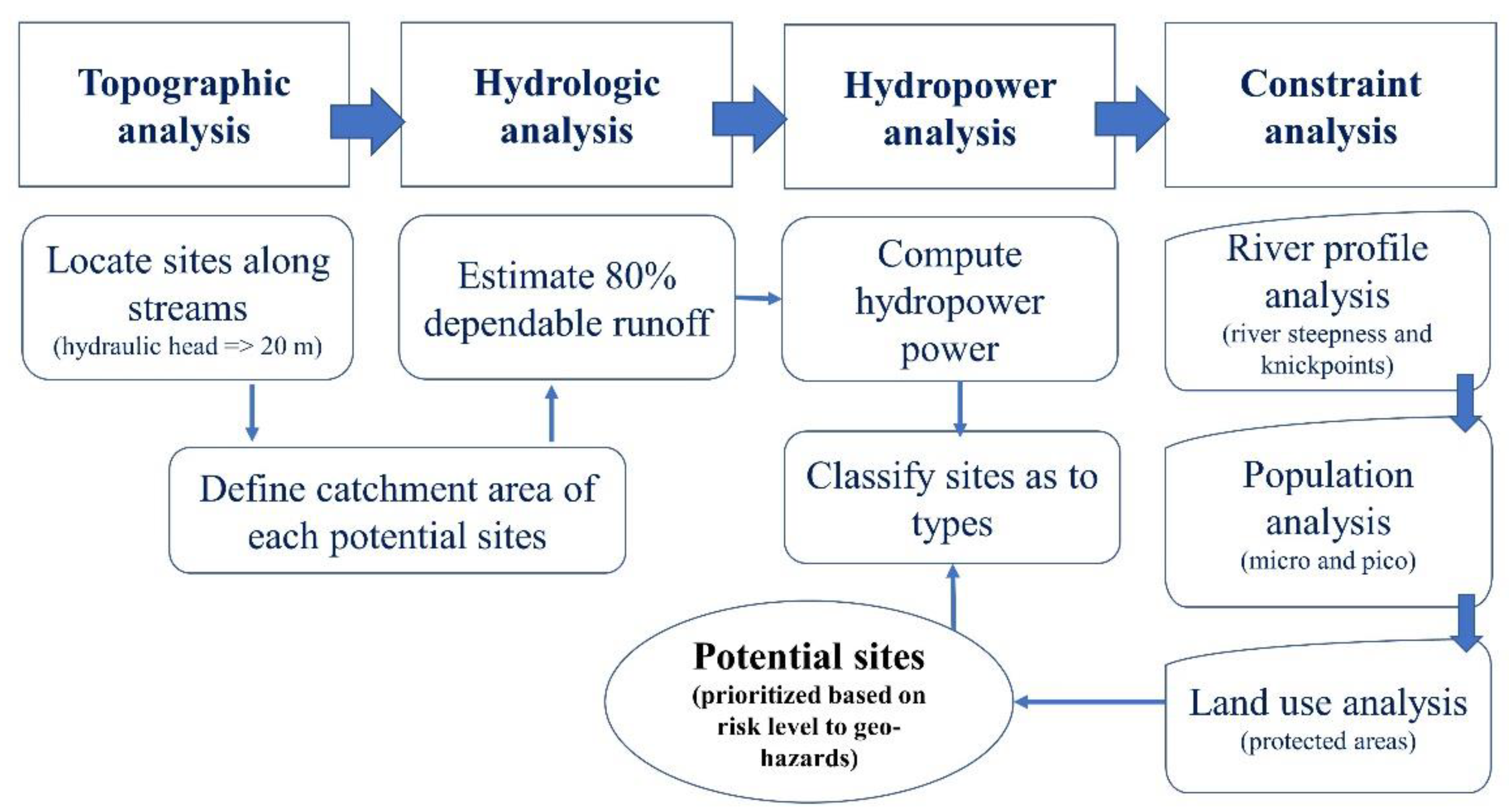
Figure 1. General workflow of the identification of potential small-scale hydropower sites.
Energies 15 01130 g001
Figure 2. A model builder created for locating points with a minimum elevation head of 20 m along river channels. The yellow-colored rectangle with the hammer sign indicates the toolset used in the analysis. The blue-colored oval shape indicates the input data while the green-colored indicates the output.
Energies 15 01130 g002
Figure 3. Points clustering on river segments. The selection of a representative point considers the location and the elevation value.
Energies 15 01130 g003
Figure 4. Process of CN raster creation from the landcover and HSG raster datasets. (a) The landcover raster is regrouped into landuses based on Table 2 and reclassified with new pixel values. (b) The reclassified landcover raster and its description. (c) The soil raster with its raster value added to the landcover raster in (b). (d) The sum of landcover and soil rasters reclassified according to the appropriate CN values of Table 2.
Energies 15 01130 g004
Figure 5. An example of a flow duration curve showing the equivalent flow of 10 m3/s at 80% flow exceedance.
Energies 15 01130 g005
Figure 6. The Bohol Island, its drainage network, the three existing hydropower plants, and the major watersheds.
Energies 15 01130 g006
Figure 7. Spatial distribution of potential small-scale hydropower sites identified through topographic analysis, the stream order, corresponding catchment, and the drainage network.
Energies 15 01130 g007
Figure 8. The number of sites, elevation head, and average catchment area of the identified potential small-scale hydropower sites under different stream orders.
Energies 15 01130 g008
Figure 9. Spatial variation of (a) mean annual precipitation, (b) mean annual runoff depth, and (c) mean monthly runoff estimated using CN method.
Energies 15 01130 g009
Figure 10. Flow estimates, stream order, and catchment area of the identified sites. (a) Average catchment area and flow by stream order. (b) Flow-catchment area relationship under first-order stream. (c) First stream order potential sites’ flow-catchment area relationship.
Energies 15 01130 g010
Figure 11. Observed and estimated flow at the LHEP site. The potential hydropower computation uses the flow value estimated by the CN method at 80% dependability.
Energies 15 01130 g011
Figure 12. Spatial distribution of the 94 potential small-scale hydropower sites, their types and the geo-hazard risk levels, and the protected area.
Energies 15 01130 g012
Table 1. List of datasets, their sources, format, derived layer, and type used in the study.
DataSourceData FormatDerived LayerType
5-m IfSAR DEM DA-BAR project 1TIFFStream
Elevation head
Raster
Hydrologic Soil Group (HSG) DataORNL DAAC 2TIFFCurve number Raster
Precipitation WorldClim 3TIFFAverage monthly precipitationRaster
Protected areaWDPA 4
DENR 7 5
Shapefile Vector
Local flow and rainfall dataLoboc Hydroelectric Plant (LHEP)Spreadsheet
2015 CENSUS (barangay population)PSA 6SpreadsheetPopulation density Vector/Raster
Annual global land cover change mapsCopernicus 7 TIFFLand cover/land useRaster
Barangay boundaryPhilGIS 8Shapefile Population density mapRaster
1 Small scale irrigation project (SSIP) funded by the Department of Agriculture—Bureau of Agricultural Research (DA-BAR), Philippines. 2 Global hydrologic soil groups (HYSOGs250m) for curve number-based runoff modeling—https://daac.ornl.gov/ (accessed on 25 August 2021) —Oak Ridge National Laboratory Distributed Active Archive Center (ORNL DAAC), NASA Earth Data. 3 WorldClim is a database of high spatial resolution global weather and climate data. https://www.worldclim.org/data/worldclim21.html (accessed on 1 September 2021). 4 World database on protected areas (WDPA) www.protectedplanet.net (accessed on 5 September 2021). 5 Philippine Department of Environment and Natural Resources (DENR) 7. 6 Philippine Statistics Authority https://psa.gov.ph/ (accessed on 8 June 2021). 7 Copernicus Land Monitoring Service https://land.copernicus.eu/ (accessed on 10 August 2021). 8 Philippine GIS data clearinghouse http://philgis.org/ (accessed on 10 June 2021).
Table 2. Description and Curve Numbers of different land uses and hydrologic conditions under different hydrologic soil groups (TR-55).
Land Use (USDA-SCS)Cover DescriptionCurve Number for Hydrologic Soil Group
Cover Type and Hydrologic Condition% Impervious AreasABCD
AgriculturalRow-crops-straight rows + crop residue cover good condition (1) 64758285
CommercialUrban Districts: Commercial and Business8589929495
Forest Woods (2)—Good Condition 30557077
Grass/pasture Pasture, Grassland, or Range (3)—Good Condition 39617480
High density residential Residential districts by average lot size: 1/8 acre or less6577859092
Industrial Urban district: Industrial7281889193
Low density residential Residential districts by average lot size: ½-acre lot2554708085
Open spaces Open Space (lawns, parks, golf courses, cemeteries, etc.) (4) Fair Condition (grass cover 50% to 70%) 49697984
Parking and paved areas Impervious areas: Paved parking lots, roofs, driveways, etc. (excluding right-of-way)10098989898
Water/wetlands 00000
Notes: (1) Hydraulic condition is based on combination factors that affect infiltration and runoff, including (a) density and canopy of vegetative areas, (b) amount of year-round cover, (c) amount of grass or close-seeded legumes, (d) percent of residue on the land surface (good ≥ 20%), and © degree of surface roughness. (2) Good: Woods are protected from grazing, and litter and brush adequately cover the soil. (3) Good: >75% ground cover and lightly or only occasionally grazed. (4) ‘CN’s shown are equivalent to those of pasture. Composite CNs may be computed for other combinations of open space cover types. Source: https://engineering.purdue.edu/mapserve/LTHIA7/documentation/scs.htm (accessed on 5 September 2021).
Table 3. The Global hydrologic soil group and its description.
Pixel ValuesDescription
1HSG-A: low runoff potential (>90% sand and <10% clay)
2HSG-B: moderately low runoff potential (50–90% sand and 10–20% clay)
3HSG-C: moderately high runoff potential (<50% sand and 20–40% clay)
4HSG-D: high runoff potential (<50% sand and >40% clay)
11HSG-A/D: high runoff potential unless drained (>90% sand and <10% clay)
12HSG-B/D: high runoff potential unless drained (50–90% sand and 10–20% clay)
13HSG-C/D: high runoff potential unless drained (<50% sand and 20–40% clay)
14HSG-D/D: high runoff potential unless drained (<50% sand and >40% clay)
Source: Ross, C.W., L. Prihodko, J. Anchang, S. Kumar, W. Ji, and N.P. Hanan. 2018. HYSOGs250m, global gridded hydrologic soil groups for curve number-based runoff modeling. Scientific Data 5, 180091. https://doi.org/10.1038/sdata.2018.91 (accessed on 12 August 2021).
Table 4. Classification of small-scale hydropower systems based on power capacity and the potential applications to a range of beneficiaries.
TypePower Output 1,2Applicability 1
Small1–10 MWSmall communities with a possibility to supply electricity to a regional grid
Mini100 kW–1 MWSmall factory or isolated communities
Micro5–100 kWSmall, isolated communities
Pico<5 kW1–2 houses
1 https://sswm.info (accessed on 20 July 2021). 2 [20,42].
Table 5. Types of small-scale hydropower sites, count, power capacity, and energy generation per watershed.
WatershedTypePower, kWCountEnergy, MWh
Loboc Watershed 10,1692930,045
Small6484419,159
Mini335469911
Micro31615934
Pico14442
Wahig–Inabanga Watershed 569151682
Mini35611051
Micro20011592
Pico13340
Other Watersheds 2857508441
Mini197955846
Micro853392520
Pico25675
Small (1–10 MW); mini (0.1–1 MW); micro (5–100 kW); and pico (<5 kW). Please see Appendix B Table A1 for details per site.
Table 6. Geo-hazard risk levels associated with the small-scale hydropower type and the power potential.
Geo-Hazard Risk LevelTypeNumber of SitesHydropower
Count Total Power, kWTotal
Very highMini 132676907
Micro31 231
High Small 13813411591
Micro24 197
Pico13 53
MediumSmall1917904078
Mini4 2209
Micro4 80
LowSmall2533533895
Mini1 411
Micro2 131
Very lowMini61028373122
Micro4 285
Total 9413,595
Publisher’s Note: MDPI stays neutral with regard to jurisdictional claims in published maps and institutional affiliations.