
A Novel Measurement-Based Method for Assessing Global Warming Mitigation via High-Albedo Solutions

 , ,
, ,  ,
,  and
and 
Abstract
:1. Introduction
2. Methods Review
3. The Novel Method
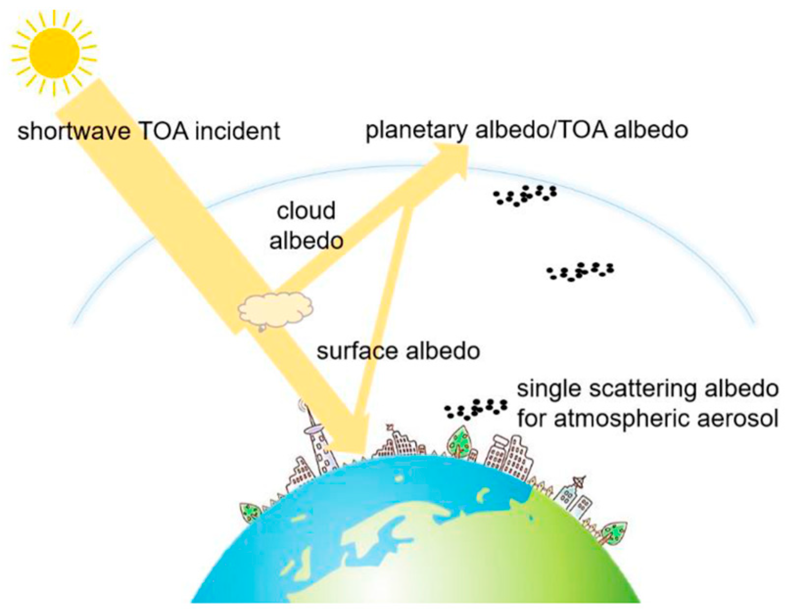
3.1. Model
- WTOA, solar irradiation per unit area at the top of atmosphere which strikes a virtual surface parallel to the SUT;
- Win, solar irradiation per unit area which hits the SUT; and
- Wout, global solar irradiation reflected by SUT which exits from the top of atmosphere. Diffusive reflection is supposed.
3.2. Calibration
- Downward and upward paths generally lay on different directions, which may be characterized by different atmospheric compositions producing different energy absorptions. Furthermore, a more precisely upward path, as shown in Figure 3, is related to a diffusive reflection, which implies a non-unique reflection beam but a spread reflection pattern. Atmospheric layers crossed by upwards paths may obtain different energy absorptions. Atmospheric refraction may also introduce further errors.
- Surface albedo changes during the diurnal time in function of solar zenith angle [33].
- Calculation of WTOA is affected by intrinsic errors.
- Errors made by albedometer and pyranometer on measuring α and Win will be better investigated in Section 4, dedicated to instrumentation.
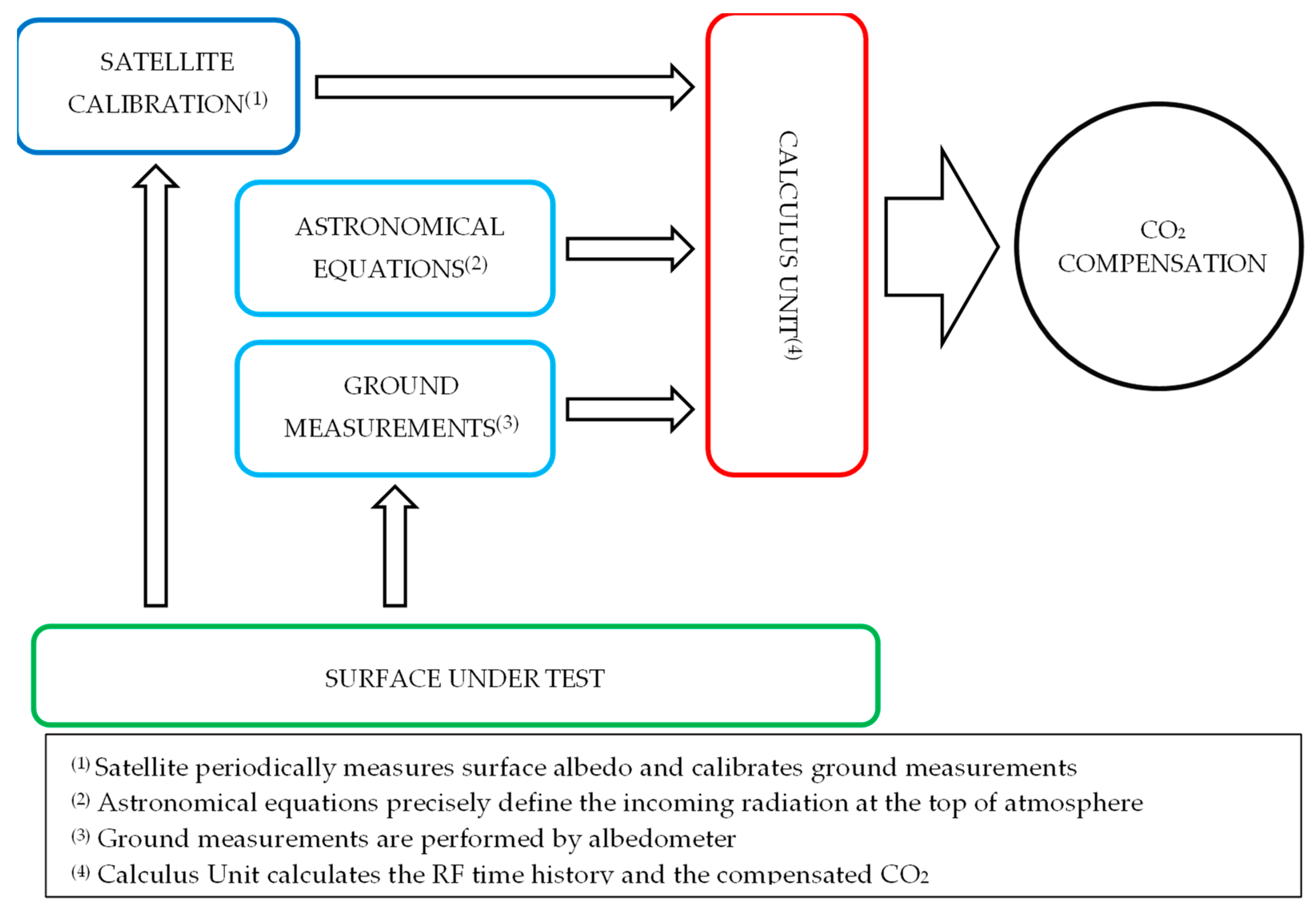
4. Experimental Set-Up: RF-Meter
- minimum spatial resolution: 100 m2;
- average revisit time: 5 days;
- spectral characteristics suitable to IPCC radiative forcing definition and albedometer spectral standards.
- albedometer, technical features are reported in Table 2;
- weather station;
- Calculus Unit based on Field Point system.
Spectral Discussion
5. Satellite Characteristics
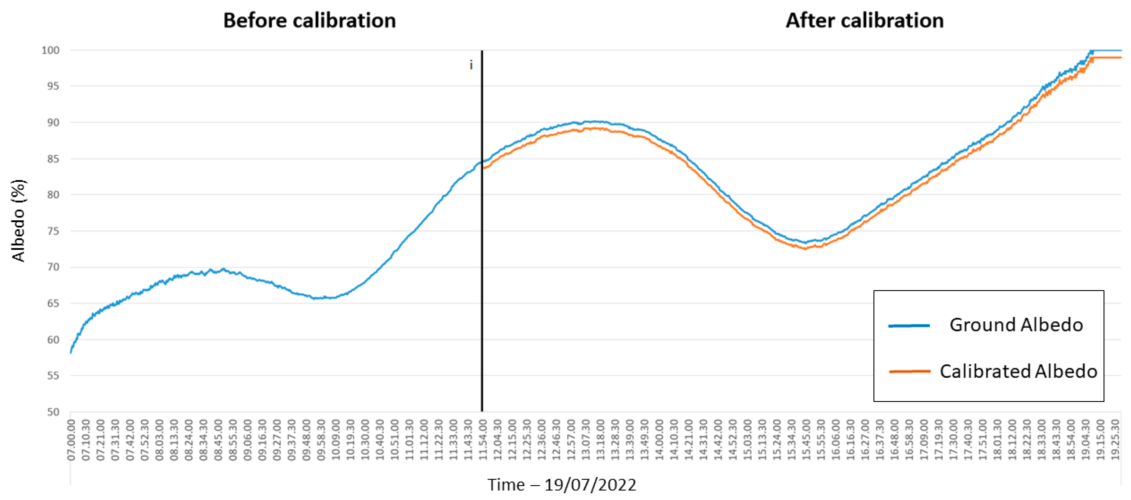
6. Example of Calibration
7. Conclusions
Author Contributions
Funding
Institutional Review Board Statement
Informed Consent Statement
Data Availability Statement
Acknowledgments
Conflicts of Interest
References
- Edenhofer, O.; Pichs-Madruga, R.; Sokona, Y.; Farahani, E.; Kadner, S.; Seyboth, K.; Adler, A.; Baum, I.; Brunner, S.; Eickemeier, P.; et al. (Eds.) Contribution of Working Group III to the Fifth Assessment Report of the Intergovernmental Panel on Climate Change. In Climate Change 2014: Mitigation of Climate Change; Cambridge University Press: Cambridge, UK; New York, NY, USA, 2014. [Google Scholar]
- Directive 2003/87/EC; Establishing a System for Greenhouse Gas Emission Allowance Trading within the Union and Amending Council Directive 96/61/EC. European Parliament and of the Council: Washington, DC, USA, 2013.
- Masson-Delmotte, V.; Zhai, P.; Pirani, A.; Connors, S.L.; Péan, C.; Berger, S.; Caud, N.; Chen, Y.; Goldfarb, L.; Gomis, M.I.; et al. (Eds.) IPCC 2021: Summary for Policymakers. In Climate Change 2021: The Physical Science Basis. Contribution of Working Group I to the Sixth Assessment Report of the Intergovernmental Panel on Climate Change; Cambridge University Press: Cambridge, UK; New York, NY, USA, 2021. [Google Scholar]
- Akbari, H.; Menon, S.; Rosenfeld, A. Global cooling: Increasing world-wide urban albedos to offset CO2. Clim. Chang. 2009, 94, 275–286. [Google Scholar] [CrossRef]
- Rossi, F.; Cotana, F.; Filipponi, M.; Nicolini, A.; Menon, S.; Rosenfeld, A. Cool roofs as a strategy to tackle Global Warming: Economical and technical opportunities. Adv. Build. Energy Res. 2013, 7, 254–268. [Google Scholar] [CrossRef]
- Taha, H. Urban climates and heat islands: Albedo, evapotranspiration, and anthropogenic heat. Energy Build. 1997, 25, 99–103. [Google Scholar] [CrossRef] [Green Version]
- Menon, S.; Akbari, H.; Mahanama, S.; Sednev, I.; Levinson, R.M. Radiative forcing and temperature response to changes in urban albedos and associated CO2 offsets. Environ. Res. Lett. 2010, 5, 014005. [Google Scholar] [CrossRef]
- Liang, S.; Wang, D.; He, T.; Yu, Y. Remote Sensing of Earth’s Energy Budget: Synthesis and Review. Int. J. Digit. Earth 2019, 12, 737–780. [Google Scholar] [CrossRef] [Green Version]
- Seneviratne, S.I.; Phipps, S.J.; Pitman, A.J.; Hirsch, A.L.; Davin, E.L.; Donat, M.G.; Hirschi, M.; Lenton, A.; Wilhelm, M.; Kravitz, B. Land radiative management as contributor to regional-scale climate adaptation and mitigation. Nat. Geosci. 2018, 11, 88–96. [Google Scholar] [CrossRef]
- Field, L.; Ivanova, D.; Bhattacharyya, S.; Mlaker, V.; Sholtz, A.; Decca, R.; Manzara, A.; Johnson, D.; Christodoulou, E.; Walter, P.; et al. Increasing arctic sea ice albedo using localized reversible geoengineering. Earths Future 2018, 6, 882–901. [Google Scholar] [CrossRef]
- Kravitz, B.; Rasch, P.J.; Wang, H.; Robock, A.; Gabriel, C.; Boucher, O.; Cole, J.N.S.; Haywood, J.; Ji, D.; Jones, A.; et al. The climate effects of increasing ocean albedo: An idealized representation of solar geoengineering. Atmos. Chem. Phys. 2018, 18, 13097–13113. [Google Scholar] [CrossRef] [Green Version]
- Huang, H.; Xue, Y.; Chilukoti, N.; Liu, Y.; Chen, G.; Diallo, I. Assessing global and regional effects of reconstructed land use and land cover change on climate since 1950 using a coupled land–atmosphere–ocean model. J. Clim. 2020, 33, 8997–9013. [Google Scholar] [CrossRef]
- Laguë, M.M.; Bonan, G.B.; Swann, A.L.S. Separating the impact of individual land surface properties on the terrestrial surface energy budget in both the coupled and uncoupled land–atmosphere system. J. Clim. 2019, 32, 5725–5744. [Google Scholar] [CrossRef] [Green Version]
- Bright, R.M.; Lund, M.T. CO2-equivalence metrics for surface albedo change based on the radiative forcing concept: A critical review. Atmos. Chem. Phys. 2021, 21, 9887–9907. [Google Scholar] [CrossRef]
- Smith, C.J.; Kramer, R.J.; Myhre, G.; Alterskjær, K.; Collins, W.; Sima, A.; Boucher, O.; Dufresne, J.L.; Nabat, P.; Michou, M.; et al. Effective radiative forcing and adjustments in CMIP6 models. Atmos. Chem. Phys. 2020, 20, 9591–9618. [Google Scholar] [CrossRef]
- Hansen, J.; Sato, M.; Ruedy, R.; Nazarenko, L.; Lacis, A.; Schmidt, G.A.; Russell, G.; Aleinov, I.; Bauer, M.; Bauer, S.; et al. Efficacy of climate forcings. J. Geophys. Res. Atmos. 2005, 110, D18104. [Google Scholar] [CrossRef]
- Myhre, G.; Shindell, D.; Bréon, F.; Collins, W.; Fuglestvedt, J.; Huang, J.; Koch, D.; Lamarque, J.; Lee, D.; Mendoza, B.; et al. Chapter 8: Anthropogenic and Natural Radiative Forcing: In Climate Change 2013: The Physical Science Basis. Contribution of Working Group I to the Fifth Assement Report of the Integovernmental Panel on Climate Change; Cambridge University Press: Cambridge, UK; New York, NY, USA, 2013; pp. 659–740. [Google Scholar]
- Myhre, G.; Highwood, E.J.; Shine, K.P.; Stordal, F. New estimtes of raditive forcing due to well mixed greenhouse gases. Geophys. Res. Lett. 1998, 25, 2715–2718. [Google Scholar] [CrossRef]
- Forster, P.; Ramaswamy, V.; Artaxo, P.; Berntsen, T.; Betts, R.; Fahey, D.W.; Haywood, J.; Lean, J.; Lowe, D.C.; Myhre, G.; et al. Changes in atmospheric consituents and in radiative forcing. In Climate Change 2007: The Physical Science Basis. Contribution of Working Group I to the Fourth Assessment Report of the Intergovernmental Panel on Climate Change; Cambridge University Press: Cambridge, UK; New York, NY, USA, 2007. [Google Scholar]
- Betts, R.A. Offset of the potential carbon sink from boreal forestation by decreases in surface albedo. Nature 2000, 408, 187–190. [Google Scholar] [CrossRef]
- Sciusco, P.; Chen, J.; Abraha, M.; Lei, C.; Robertson, G.P.; Lafortezza, R.; Shirkey, G.; Ouyang, Z.; Zhang, R.; John, R. Spatiotemporal variations of albedo in managed agricultural landscapes: Inferences to global warming impacts (GWI). Landsc. Ecol. 2020, 35, 1385–1402. [Google Scholar] [CrossRef]
- Lenton, T.M.; Vaughan, N.E. The radiative forcing potential of different climate geoengineering options. Atmos. Chem. Phys. 2009, 9, 5539–5561. [Google Scholar] [CrossRef] [Green Version]
- Cherubini, F.; Bright, R.M.; Strømman, A.H. Site-specific global warming potentials of biogenic CO2 for bioenergy: Contributions from carbon fluxes and albedo dynamics. Environ. Res. Lett. 2012, 7, 045902. [Google Scholar] [CrossRef]
- Bright, R.M.; Bogren, W.; Bernier, P.Y.; Astrup, R. Carbon equivalent metrics for albedo changes in land management contexts: Relevance of the time dimension. Ecol. Appl. 2016, 26, 1868–1880. [Google Scholar] [CrossRef]
- Joos, F.; Bruna, M. Pulse response functions are cost-efficient tools to model the link between carbon emissions, atmospheric CO2 and global warming. Phys. Chem. Earth 1996, 21, 471–476. [Google Scholar] [CrossRef]
- Joos, F.; Prentice, I.C.; Sitch, S.; Meyer, R.; Hooss, G.; Plattner, G.K.; Gerber, S.; Hasselmann, K. Global warming feedbacks on terrestrial carbon uptake under the Intergovernmental Panel on Climate Change (IPCC) emission scenarios. Glob. Biogeochem. Cycles 2001, 15, 891–907. [Google Scholar] [CrossRef] [Green Version]
- Bright, R.M.; O’Halloran, T.L. Developing a monthly radiative kernel for surface albedo change from satellite climatologies of Earth’s shortwave radiation budget: CACK v1.0. Geosci. Model Dev. 2019, 12, 3975–3990. [Google Scholar] [CrossRef] [Green Version]
- Shine, K.; Derwent, R.G.; Wuebbles, D.J.; Morcrette, J.J. Radiative forcing of climate. In Climate Change: The IPCC Scientific Assessment; Cambridge University Press: New York, NY, USA; Melbourne, Australia, 1990. [Google Scholar]
- Rogers, J.D.; Stephens, R.D. Absolute infrared intensities for F-113 and F-114 and an assessment of their greenhouse warming potential relative to other chlorofluorocarbons. J. Geophys. Res. Atmos. 1988, 93, 2423–2428. [Google Scholar] [CrossRef]
- Sieber, P.; Ericsson, N.; Hansson, P.A. Climate impact of surface albedo change in Life Cycle Assessment: Implications of site and time dependence. Environ. Impact Assess. Rev. 2019, 77, 191–200. [Google Scholar] [CrossRef]
- Zhang, X.; Jiao, Z.; Zhao, C.; Qu, Y.; Liu, Q.; Zhang, H.; Tong, Y.; Wang, C.; Li, S.; Guo, J.; et al. Review of Land Surface Albedo: Variance Characteristics, Climate Effect and Management Strategy. Remote Sens. 2022, 14, 1382. [Google Scholar] [CrossRef]
- Iqbal, M. An Introduction to Solar Radiation; Academic Press: Cambridge, MA, USA, 1983. [Google Scholar]
- Liu, J.C.; Schaaf, C.B.; Strahler, A.H.; Jiao, Z.T.; Shuai, Y.M.; Zhang, Q.L.; Roman, M.O.; Augustine, J.A.; Dutton, E.G. Validation of Moderate Resolution Imaging Spectroradiometer (MODIS) albedo retrieval algorithm: Dependence of albedo on solar zenith angle. J. Geophys. Res.-Atmos. 2009, 114, D1106. [Google Scholar] [CrossRef]
- Bonafoni, S.; Sekertekin, A. Albedo retrieval from Sentinel-2 by new narrow-to-broadband conversion coefficients. IEEE Geosci. Remote Sens. Lett. 2020, 17, 1618–1622. [Google Scholar] [CrossRef]
- ASTM-E1918-06; Standard Test Method for Measuring Solar Reflectance of Horizontal and Low-Sloped Surfaces in the Field. ASTM International, ASTM: West Conshohocken, PA, USA, 2015; pp. 1–3.
- Liang, S. Narrowband to broadband conversions of land surface albedo—I Algorithms. Remote Sens. Environ. 2001, 76, 213–238. [Google Scholar] [CrossRef]
- Copernicus Program. Available online: http://www.esa.int/Our_Activities/Observing_the_Earth/Copernicus/Overview4 (accessed on 10 June 2022).
- Sentinel-2 Missions. Available online: https://sentinel.esa.int/web/sentinel/user-guides/sentinel-2-msi (accessed on 10 June 2022).
- Copernicus Open Access Hub. Available online: https://scihub.copernicus.eu/dhus/#/home (accessed on 10 June 2022).
- Qu, Y.; Liang, S.; Liu, Q.; He, T.; Liu, S.; Li, X. Mapping Surface Broadband Albedo from Satellite Observations: A Review of Literatures on Algorithms and Products. Remote Sens. 2015, 7, 990–1020. [Google Scholar] [CrossRef] [Green Version]
- Wang, D.; Liang, S.; He, T.; Yu, Y.; Schaaf, C.; Wang, Z. Estimating daily mean land surface albedo from MODIS data. J. Geophys. Res.-Atmos. 2015, 120, 4825–4841. [Google Scholar] [CrossRef]
- He, T.; Zhang, Y.; Liang, S.; Yu, Y.; Wang, D. Developing land surface directional reflectance and albedo products from geostationary GOES-R and Himawari data: Theoretical basis, operational implementation, and validation. Remote Sens. 2019, 11, 2655. [Google Scholar] [CrossRef] [Green Version]
- Guo, T.; He, T.; Liang, S.; Roujean, J.; Zhou, Y.; Huang, X. Multi-decadal analysis of high-resolution albedo changes induced by urbanization over contrasted Chinese cities based on Landsat data. Remote Sens. Environ. 2022, 269, 112832. [Google Scholar] [CrossRef]
- Gasparrini, A.; Guo, Y.; Sera, F.; Vicedo-Cabrera, A.M.; Huber, V.; Tong, S.; Coelho, M.D.S.Z.S.; Saldiva, P.H.N.; Lavigne, E.; Correa, P.M.; et al. Projections of temperature- related excess mortality under climate change scenarios. Lancet Planet Health 2017, 1, e360–e367. [Google Scholar] [CrossRef]
- Howie, P.; Atakhanova, Z. Assessing initial conditions and ETS outcomes in a fossil-fuel dependent economy. Energy Strategy Rev. 2022, 40, 100818. [Google Scholar] [CrossRef]


| Methods/Models | Metric | CO2 Offset | Δα | Notes |
|---|---|---|---|---|
| Betts et al. (2000) [20] | EESF | 0.70 kg C/m2 | 0.01 | AF = 0.5 |
| Akbari et al. (2009) [4] | EESF | 2.55 kg CO2eq/m2 | 0.01 | AF = 0.55 |
| Menon et al. (2010) [7] | EESF | 3.26 kg CO2eq/m2 | 0.01 | AF = 0.55 |
| Rossi et al. (2013) [5] | EESF | 3.20 kg CO2eq/m2 | 0.01 | AF = 0.5 |
| Sieber et al. (2019) [30] | GWP | 69 g CO2eq/m2 year | 0.05 | TH = 100 year |
| Bright et al. (2021) [14] | EESF | 3.50–6.90 kg CO2eq/m2 | 0.04 | AF = 0.3–0.6 |
| Bright et al. (2021) [14] | TDEE | 3.0 kg CO2eq/m2 | 0.04 | TH = 80 year |
| Albedometer 1 | |
|---|---|
| Technical Features | Specifications |
| Model | LP PYRA 05 |
| Sensor | Thermopile |
| Typical sensitivity | 10 W/m2 |
| Measuring range | 0 ÷ 2000 W/m2 |
| Viewing angle | 2π sr |
| Spectral range (50%) | 305 nm ÷ 2800 nm |
| Operating temperature | −40 °C ÷ 80 °C |
Publisher’s Note: MDPI stays neutral with regard to jurisdictional claims in published maps and institutional affiliations. |
© 2022 by the authors. Licensee MDPI, Basel, Switzerland. This article is an open access article distributed under the terms and conditions of the Creative Commons Attribution (CC BY) license (https://creativecommons.org/licenses/by/4.0/).
Share and Cite
Rossi, F.; Filipponi, M.; Castellani, B.; Bonafoni, S.; Ghenai, C. A Novel Measurement-Based Method for Assessing Global Warming Mitigation via High-Albedo Solutions. Energies 2022, 15, 5695. https://doi.org/10.3390/en15155695
Rossi F, Filipponi M, Castellani B, Bonafoni S, Ghenai C. A Novel Measurement-Based Method for Assessing Global Warming Mitigation via High-Albedo Solutions. Energies. 2022; 15(15):5695. https://doi.org/10.3390/en15155695
Chicago/Turabian StyleRossi, Federico, Mirko Filipponi, Beatrice Castellani, Stefania Bonafoni, and Chaouki Ghenai. 2022. "A Novel Measurement-Based Method for Assessing Global Warming Mitigation via High-Albedo Solutions" Energies 15, no. 15: 5695. https://doi.org/10.3390/en15155695
APA StyleRossi, F., Filipponi, M., Castellani, B., Bonafoni, S., & Ghenai, C. (2022). A Novel Measurement-Based Method for Assessing Global Warming Mitigation via High-Albedo Solutions. Energies, 15(15), 5695. https://doi.org/10.3390/en15155695