Article

Multidisciplinary Geophysical Investigations over Deep Coal-Bearing Strata: A Case Study in Yangjiazhangzi, Northeast China

1
College of Energy and Mining Engineering, Shandong University of Science and Technology, Qingdao 266590, China
2
College of Geo-Exploration Science and Technology, Jilin University, Changchun 130026, China
3
School of Biological, Earth and Environmental Sciences, UNSW Australia, Kensington, NSW 2052, Australia
*
Authors to whom correspondence should be addressed.
Energies 2022, 15(15), 5689; https://doi.org/10.3390/en15155689
Submission received: 8 June 2022 / Revised: 21 July 2022 / Accepted: 4 August 2022 / Published: 5 August 2022
(This article belongs to the Special Issue Innovative Technology in Deep Coal Development)

Abstract

:
With the majority of coal mines in uncovered and semi-covered coal strata now explored and developed, most of the undiscovered coal-bearing strata are concealed. Compared with expensive drilling, deep targets such as concealed coal-bearing strata can be more efficiently and cost-effectively discovered through geophysical methods. We designed an integrated geophysical exploration approach to detect coal-bearing strata in the Yangjiazhangzi (YJZZ) area. Large-scale magnetotellurics (MT) is used to describe the geological structure along with its profile through the YJZZ area. An aeromagnetic survey was used to delineate the spatial distribution characteristics of the YJZZ syncline, a coal-bearing prospect tectonic unit. Localized exploration with controlled-source audio magnetotellurics (CSAMT) and MT reveals coal-bearing targets for drilling. Drilling results verified the targets identified through the integrated geophysical approach. Coal-bearing strata in the Benxi formation, the Taiyuan formation, and the Shanxi formation of the Permo-Carboniferous age are found between 630 and 770 m. This case study demonstrates that the multidisciplinary geophysical strategy can provide reliable results and credible data interpretation for deep coal seam resources exploration. The findings of this study can provide reference for explorers to carry out their specific exploration cases.

1. Introduction

Coal resources play an important role in national economic development around the world [1,2]. In China, coal accounts for approximately 60% of China’s primary energy production and consumption. In recent decades, with the depletion of shallow coal resources, the mining approach for coal resources has gradually developed into deep coal mining in China. The increase in buried depth not only makes coal development more difficult, but also poses a challenge to the exploration of coal resources [3,4,5].
Compared with expensive drilling, deep targets such as concealed coal-bearing strata can be more efficiently and cost-effectively discovered through geophysical methods [6,7]. Every geophysical method is directly or indirectly related to a physical property contrast of the subsurface rock and the exploration target [8,9,10]. Gravity and magnetic surveys can be used to identify rock density and magnetism, estimate tectonic boundaries and describe regional geological structures with excellent lateral resolution ability [11,12]. Electromagnetic (EM) methods, such as MT or CSAMT, provide a horizontal and vertical image of the subsurface electric resistivity structure [13,14]. According to the subsurface electrical resistivity structure, a stratigraphic depth and partition fault model can be established [15,16]. Given these properties and the usual abrupt nature of coal strata boundaries, coal seams are a potential target for different types of geophysical surveys. Since their introduction to the coal mining industries of the United Kingdom and West Germany in the 1970s, they have been widely utilized in coal exploration around the world [17]. Large-scale MT, gravity, and magnetic surveys have been used in coalfield exploration both to detect the presence of coal-bearing structures (such as sedimentary basins) and to provide information on the overall structure of study area [18]. Armstrong et.al. describe a helicopter magnetic survey in the Illawarra coalfields, and a survey in the Latrobe Valley—both in Australia—which successfully delineated the coal horizons [19]. In addition, CSAMT methods have been successfully applied to locate coal seams in coalfield exploration [20]. However, the multi-geophysical exploration research on the same deep coal-bearing strata is rarely reported. The success of geophysical survey can increase by combining two or more geophysical methods to study the same target format at different angles and scales [21]. Therefore, in this study, we designed an integrated geophysical exploration approach to detect the concealed coal-bearing strata.
The Yangjiazhangzi (YJZZ) polymetallic deposit is among the most important metallogenic regions approximately 300 km to the northeast of Beijing [22]. It abounds with multimetal minerals, such as molybdenum ore, iron ore, and copper ore. Although coal geological research shows that the YJZZ is located in a potential coal-bearing zone [23,24], coal seams have not been found in this area. In this paper, we describe multidisciplinary geophysical investigations over coal-bearing strata at the YJZZ. The geophysical survey location setting is shown in Figure 1. Firstly, we used large-scale MT surveys to describe the geological structural framework, and to determine the potential of coal-bearing structures at the YJZZ. Then, an aeromagnetic survey was carried out to delineate the spatial distribution of coal-bearing structures. Local small-scale CSAMT and MT surveys provided higher-resolution coal-bearing strata features and enough detailed evidence to classify the coal-bearing stratigraphic unit. The drilling site was determined based on the inferred depth and occurrence of coal-bearing strata. Finally, coal seams were found at 630~770 m by drilling and logging, consistent with the multidisciplinary geophysical investigations. These results demonstrate the reliability of multidisciplinary geophysical investigations in coal-bearing strata exploration.

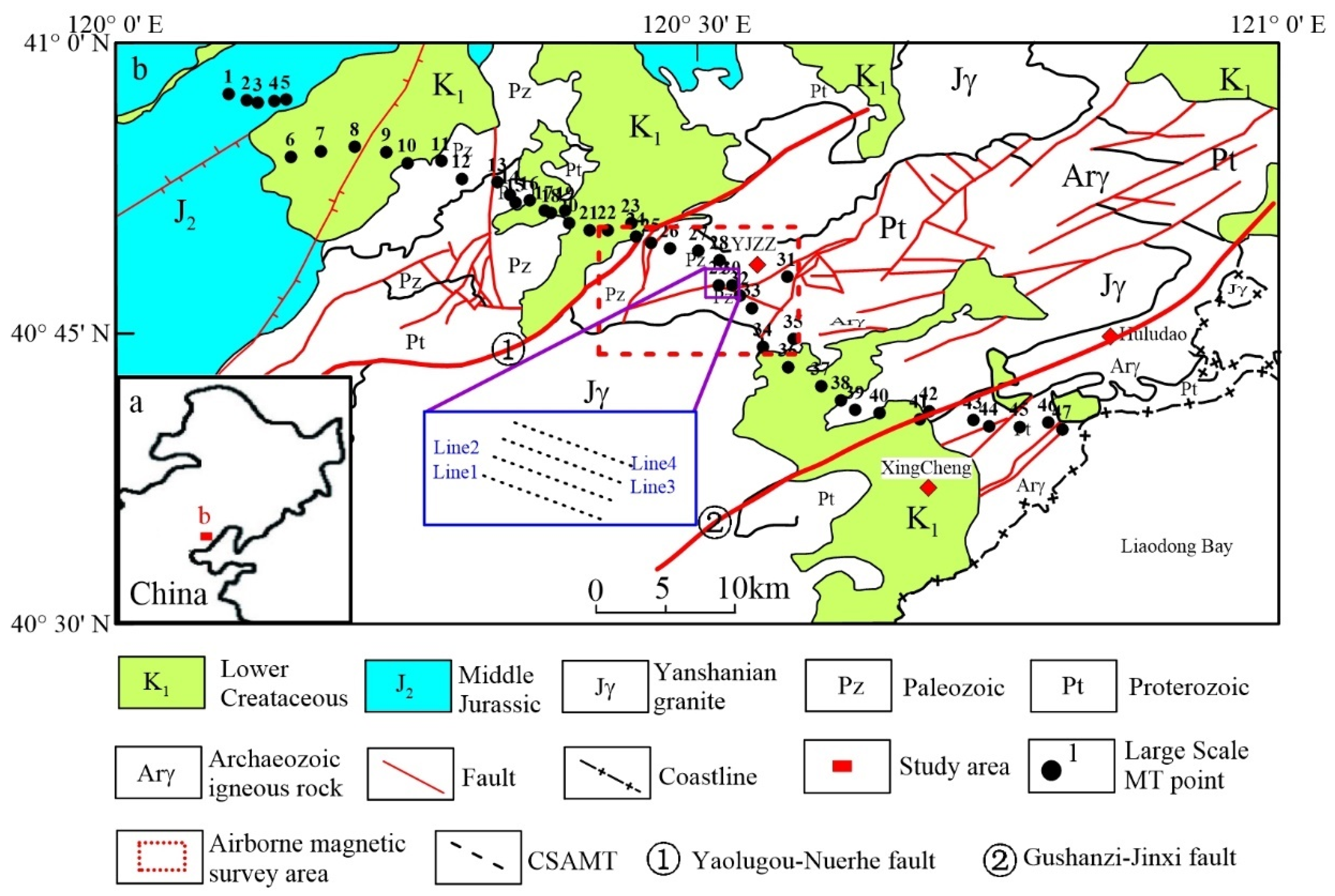
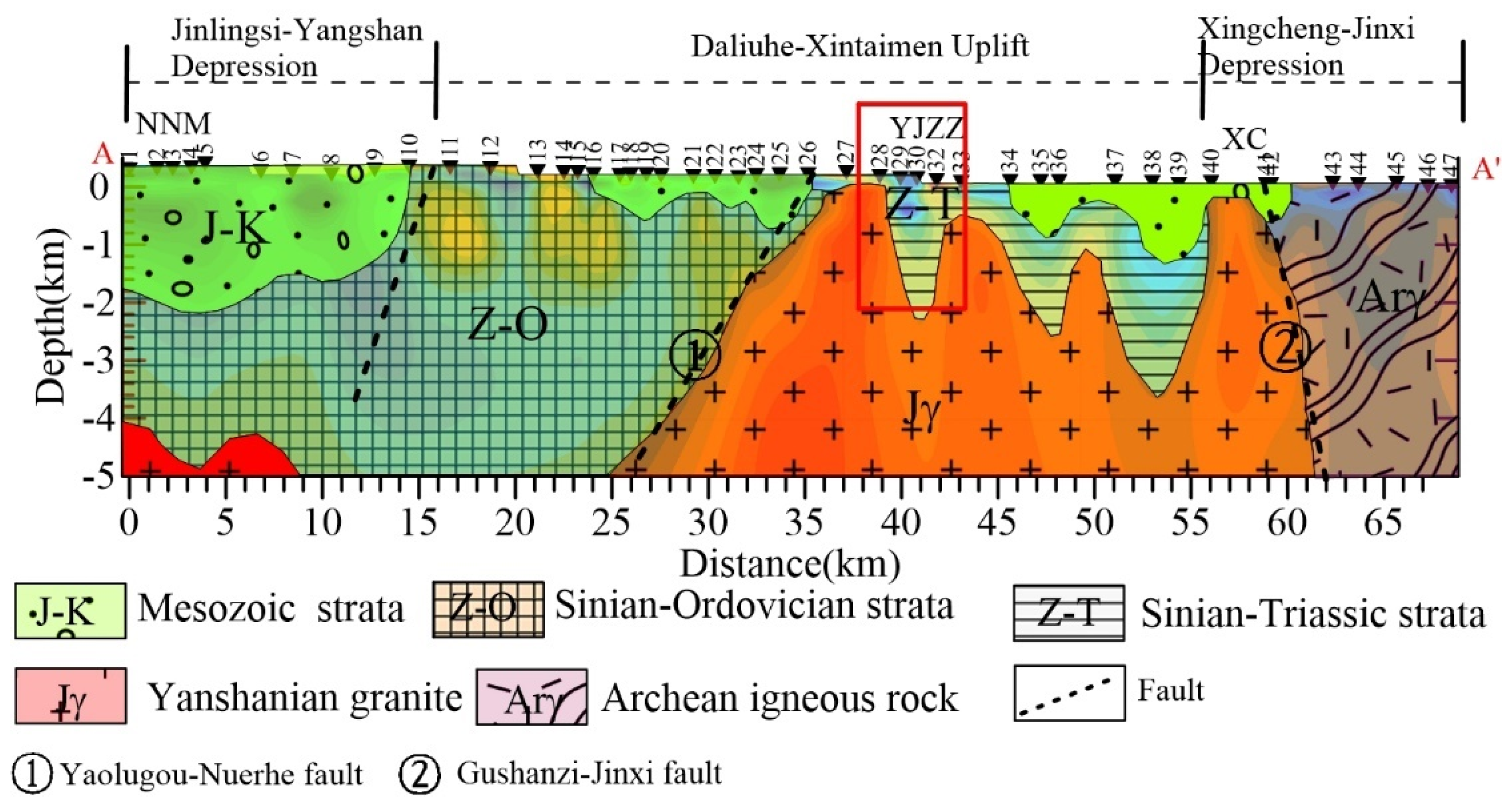
2. Regional Geological Setting

The YJZZ is located in the northeast of the North China Platform, 25 km away from Xingcheng city and in the east zone of Liaoning Province (Figure 1). The Liaoxi depression and the Shanhaiguan uplift are located in the northwest and southeast, respectively [22]. The YJZZ area is the transition zone between these two structural units, bounded by the Yaolugou–Nuerhe fault in the north and by the Gushanzi–Jinxi fault in the south [25]. In their geological history, there were three periods of sedimentary formation from the Middle Proterozoic to the Triassic [26,27]. The first was a sedimentary deposition during the period of intracontinental rift in the Proterozoic. The second was the Lower Paleozoic shallow-marine carbonate deposition. The third was a sedimentary deposition formed from the Carboniferous to the Triassic. The Carboniferous and Permian were important coal-forming periods across the world [27]. The coal-bearing strata of the North China Platform were mainly produced during these periods [28]. The thickness of the coal seam ranges from ten centimeters to several tens of meters. The buried depth and occurrence of coal seams are consistent with coal-bearing strata. From the end of the Mesozoic Triassic, a strong tectonic movement occurred in the North China Platform, which caused large-scale folds, faults and magmatism [29]. In the YJZZ area, a fold structure composed of Paleozoic strata-the YJZZ syncline-was formed, and its axial direction is northeast.

3. Integrated Geophysical Exploration
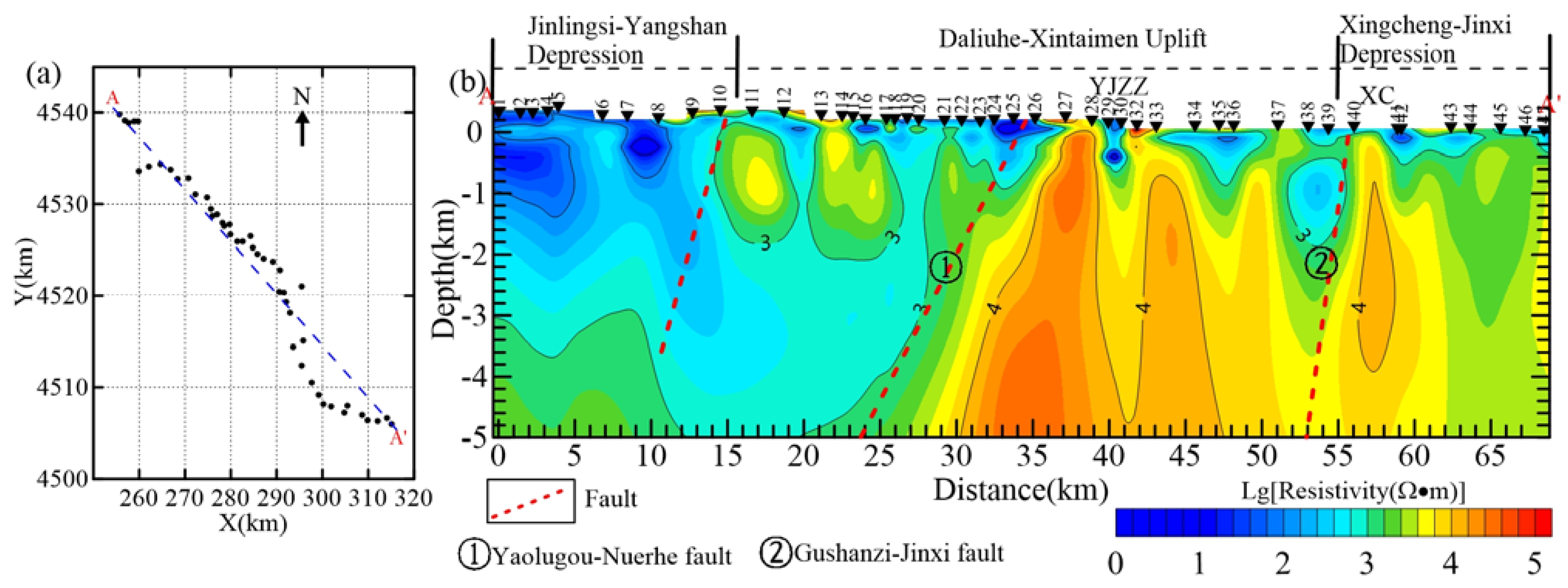
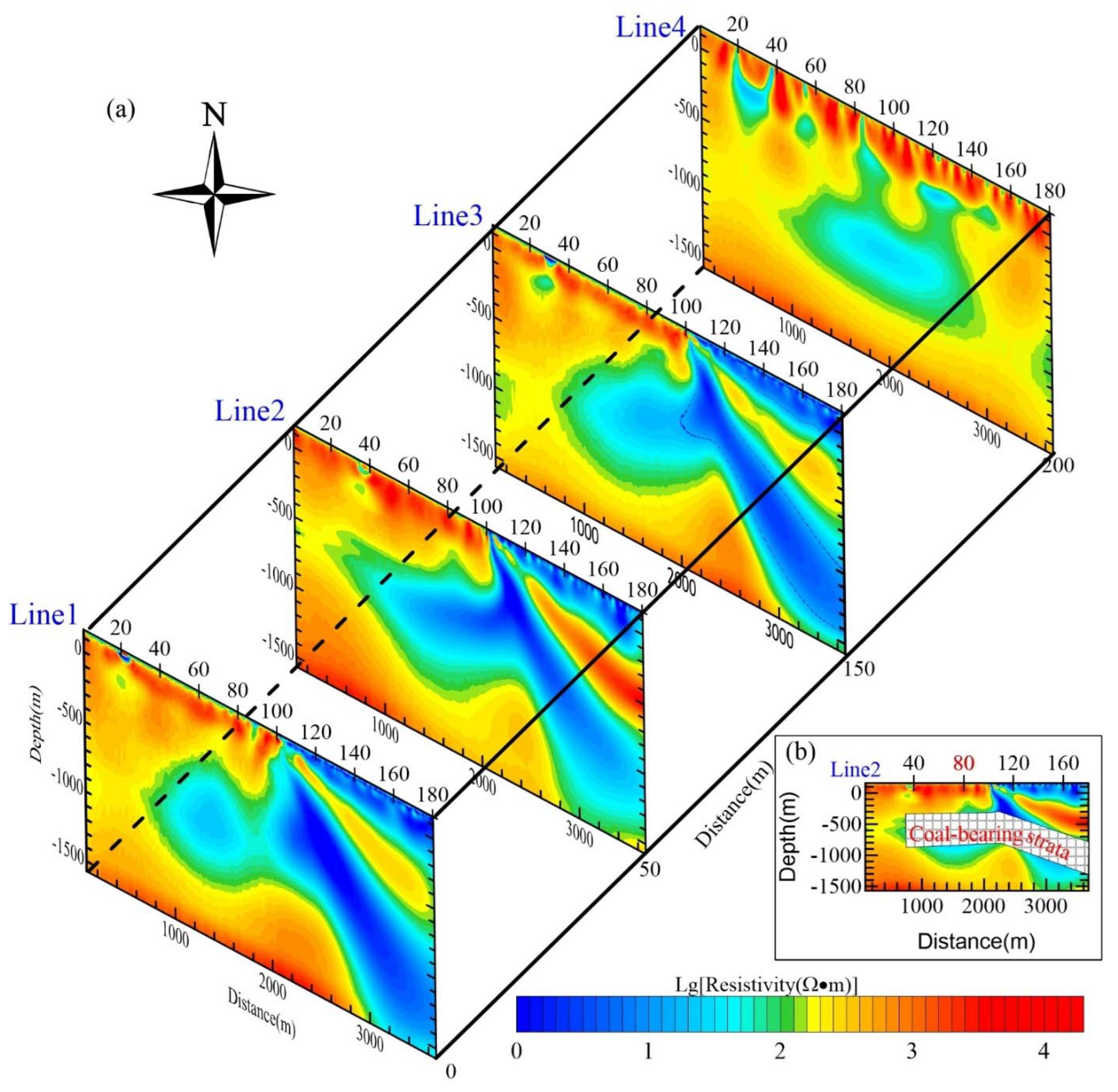
3.1. Large-Scale MT

The MT method has been widely used for studies of regional geology and sedimentary basins [30,31,32,33]. We used the MT method along a semi-regional transect as a supportive tool to delineate the large-scale resistivity structures from which we infer regional geological trends; these will further inform of possible structural environments for the distribution of coal-bearing tectonic units (especially when jointly interpreted with other geophysical observations).
In this study, we carried out an MT survey profile across the major geological structure of the northeast strike. The length of this profile is ~70 km. A Phoenix V5 system was used for data recording. Magnetic fields in the frequency range from 0.00002 to 400 Hz were measured using MTC-50H magnetic coil sensors. Electric fields were measured using non-polarizing electrodes. Horizontal electric (Ex, Ey) and magnetic (Hx, Hy) field components were recorded in NS and EW orientation. The vertical magnetic field component (Hz) was also recorded at each station. For each station, the total recording time was set to 5 h. Apparent resistivity was estimated from time series using the proprietary SSMT2000 software from Phoenix with local electric field (E) referencing. To check the quality of the MT data, a station site was selected to conduct repeat measurements. The apparent resistivity curves correspond to one another, except for a minor difference lower than 0.3 Hz. The apparent resistivity data outside the range from 0.3 to 360 Hz were discarded.
The 2D LSQR inversion method has previously been tested and proven to exhibit stable convergence in practical applications [34,35]. In this paper, we set the initial model as half space with 500 Ω m which is the approximate median of apparent resistivity. The error floor for apparent resistivity is 5%. The initial regularization parameter was set to λ = 0.3. Figure 2 shows the inversion results for the top 5 km of the MT transect.
Figure 2 shows that the resistivity increases with depth, and resistivity values at the same depth change laterally. Large resistivity differences indicate different geological tectonic units and intrusive bodies. These correspond with major geological units including the Jinlingsi–Yangshan depression, the Daliuhe–Xintaimen Uplift, and the Xingcheng–Jinxi depression. The Yaolugou–Nuerhe fault and the Gushanzi–Jinxi fault were located at Stations 26 and 40, respectively and slope to the northwest. The underground continuous high-resistance body of 5000 Ω·m in the Daliuhe–Xintaimen uplift was inferred as the Yanshanian granite intrusion. The YJZZ area is expressed as a low-resistivity zone in Stations 28–30 of the large-scale MT profile. This low resistive zone was then regarded as the potential coal-bearing strata.
A geological interpretation is shown in Figure 3. In this area, both Paleozoic and Triassic strata widely emerged in the field observation. In this case, the sediment layers in the YJZZ syncline were inferred to form from the Sinian to the Triassic. The thickness of the deposition is estimated to be 2.5 km. Therefore, based on the characteristics of regional geology and geophysics in the YJZZ area, the YJZZ syncline is a very promising coal-bearing prospect (red rectangle in Figure 3). For the deeper part, the base would be the Yanshanian granite in terms of the large resistivity values.

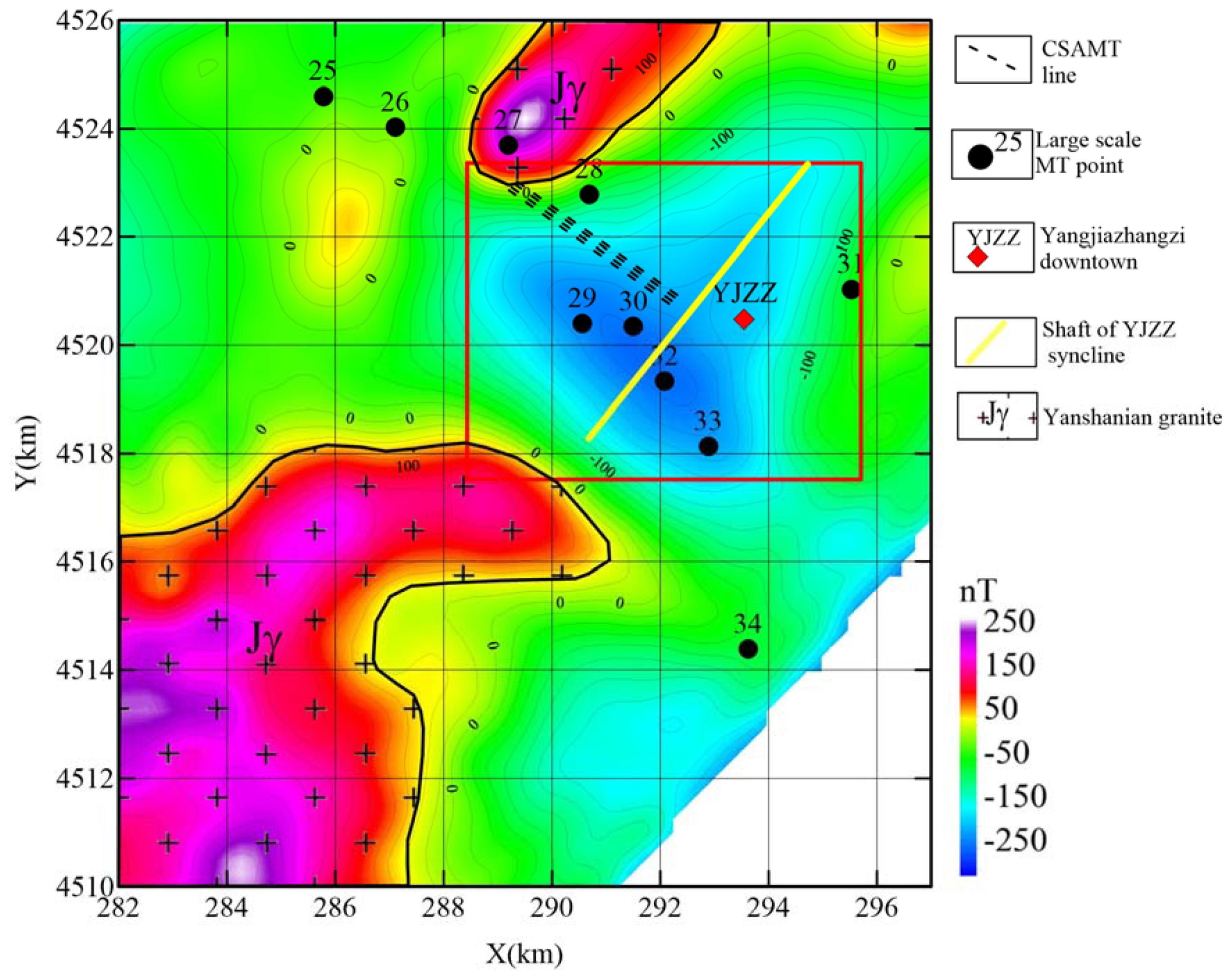
3.2. Aeromagnetic Survey

Large-scale MT results established semi-regional spatial characteristics of a coal-bearing prospect at the YJZZ along AA′ (see Figure 2). However, precise and small-scale geophysical data are necessary to locate the strata with greater detail. Two-dimensional (2D) magnetic surveys can infer the spatial distribution of underground structures through gravity and magnetic anomalies on the surface.
As the terrain is mountainous terrain in the YJZZ area, small-scale ground gravity and magnetic surveys are hard to conduct. In this case, we used an aeromagnetic survey with a fixed-wing UAV aeromagnetic detection system to delineate the 2D spatial distribution of the YJZZ syncline [36]. The sampling interval of 0.1 s and flight speed of 110–130 km/h resulted in an approximate sample spacing of 7 m. The flying altitude is 850 m following the topography. The line spacing is 100 m. Due to the higher flying height, the magnetic data need to enhance. We used the downward continuation method to enhance the observed magnetic anomaly with “Geosoft’s Oasis Montaj” [37].
Figure 4 shows the magnetic anomaly after downward continuation with the height of 200 m. The negative anomaly region corresponds to the YJZZ syncline structure which is the presumed coal-bearing area of Stations 28–33 on the MT profile (black point in Figure 4). The high positive anomalies possibly represent igneous intrusions in the Mesozoic. The aeromagnetic data show that the igneous intrusion event did not destroy the structural integrity of the YJZZ syncline. The shaft of the YJZZ syncline also corresponds with the structural strike (solid yellow line in Figure 4). Because of the similar magnetic anomalies on both sides of the shaft, we determined that the YJZZ syncline has a similar shaped limb of the fold. Therefore, we carried out a CSAMT survey on the southwest limb of the YJZZ syncline. The CSAMT survey line direction is approximate perpendicular to the shaft of the YJZZ syncline and was carried out for a more detailed investigation of the local resistivity structure (dotted black line in Figure 4).

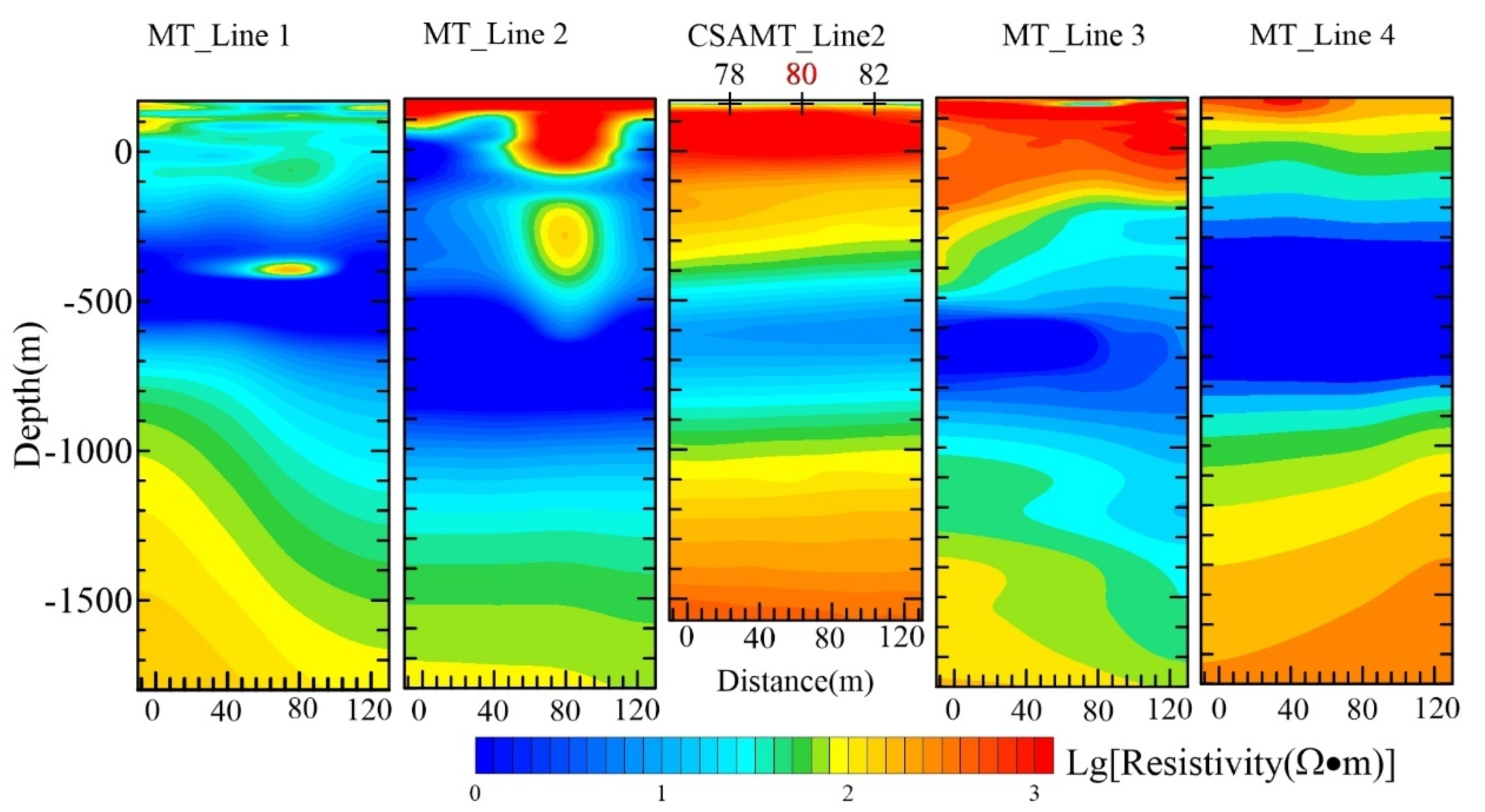
3.3. CSAMT and Small-Scale MT Survey

In Section 3.1 of this article, we recognized the location of the coal-bearing prospect from the geophysical interpretation profile of large-scale MT and potential field data. In Section 3.2, we delineated the spatial distribution of the hypothesized coal-bearing prospect from aeromagnetic surveying. Here, we combine a CSAMT and small-scale MT survey to further evaluate and determine the local coal-bearing strata.
We carried out four profiles in the N58° W direction with line spacing of 50 m and point spacing of 20 m. For each profile, the length was approximately 3.6 km with 180 measurement stations. The CSAMT data were recorded using a Phoenix V8 multifunction receiver with a TXU-30 (25 KAV) transmitter. The source of the emission was a linear electric field source, and the emission current was 16 A.
After this, we used the LSQR inversion. Figure 5a shows the inverted section of the CSAMT survey. All inverted sections are consistent. We then marked the possible coal-bearing strata on Line 2 according to the distribution of the low-resistivity zones (Figure 5b). The change in occurrence of the strata might be due to the folding. The occurrence of coal-bearing strata is horizontal at Stations 40–110 on Line 2, while the occurrence is sloping at Stations 110–180. Then, the drilling location for the borehole position was determined near the 80th station on Line 2, where the occurrence of the sedimentary strata is horizontal and the low-resistivity coal-bearing strata are shallowly buried (600 m).
Granites are widely distributed in the YJZZ area. This kind of highly resistive rocks may cause the Cagniard resistivity to increase due to the near source effect [38]. Therefore, we also carried out a small-scale MT survey at around Line 2 Station 80 of the CSAMT profile to verify the correctness of the CSAMT survey. The relative position of the small-scale MT line and CSAMT line is shown in Figure 1. The line spacing of this MT profile was 25 m and the length of each profile was 120 m with station spacing of 40 m. It took approximately 10 h to carry out MT recording. Figure 6 shows the inversion result of the small-scale MT survey. Although the calculated resistivity in the small-scale MT was lower than the CSAMT inverted section, the characteristics of resistivity with depth are identical. The lower resistivity coal-bearing strata were clearly found at the same depth of the CSAMT result.

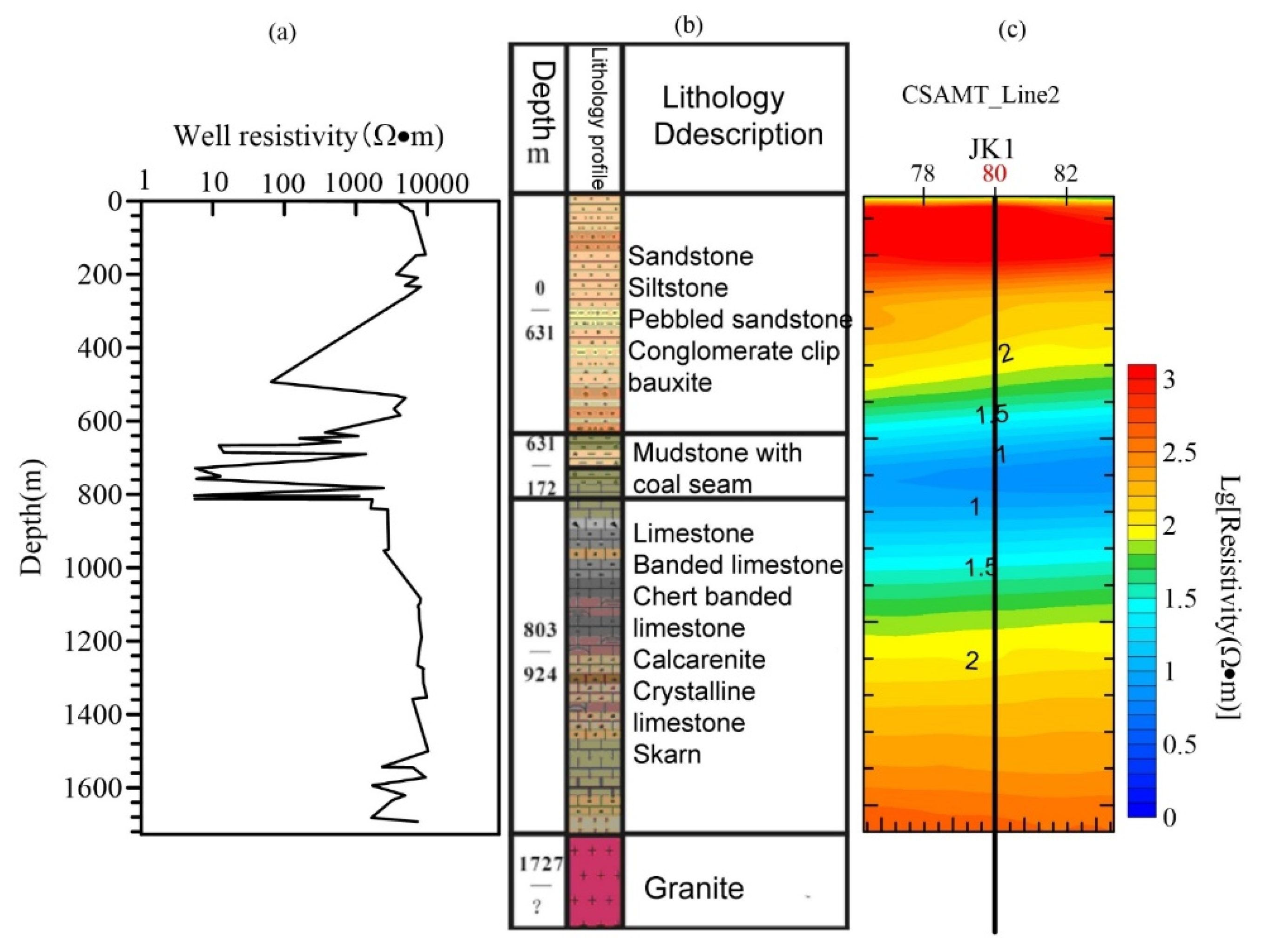
4. Drilling and Logging Interpretation

Drilling is a direct method to verify the geophysical investigation results by acquiring and analyzing underground cores [39]. Core samples recovered from diamond core exploration drilling near CSAMT Station 80, Line 2, show approximately 160 m of interleaved coal-bearing strata, from 630 to 790 m depth. Palynology suggests that this appears to be of Permo-Carboniferous age. Depths are consistent with regional estimates of the Benxi/Taiyuan/Shanxi formation by the CSAMT investigation results (Figure 7). Table 1 is the stratigraphic interpretation with log data and core drilling. The drilling result verified that the coal-bearing stratum parameters (such as thickness and buried depth), identified through the multidisciplinary geophysical investigations applied in this paper, are reliable.

5. Discussion

In this study, we choose varied methods to detect coal-bearing strata and demonstrate what information geophysics can provide at different stages (see in Table 2).
When it comes to the regional geological setting, the large-scale MT was used to describe the subsurface geological structure distribution as provided by the subsurface resistivity contrasts. Additionally, the YJZZ syncline was been recognized as a coal-bearing prospect area. Aeromagnetic survey is the connection of regional large-scale exploration and local small-scale exploration. Guided by the spatial distribution of the YJZZ syncline obtained from aeromagnetic surveying, a CSAMT survey with high resolution was carried out to detect the depth and occurrence of local coal-bearing strata. In order to avoid the possible situation that the resistivity distortion of the CSAMT survey caused by the near-field effect leads to a wrong judgement, a small-scale MT survey additionally carried out. Noticeably, the small-scale MT results support the CSAMT results. At last, the burial depth of coal-bearing strata obtained from comprehensive analysis is consistent with the drilling results. However, although the multidisciplinary geophysical investigation is efficient and cost-effective compared with drilling, it is obvious that the resolution of this multi-geophysical method based on electromagnetic method has great limitations. Coal seams cannot be identified directly from inversion results. The direct exploration method of deep coal seams still needs to be studied.

6. Summary and Conclusions

In this study, we designed a multidisciplinary geophysical investigation approach at different scales to detect coal-bearing strata in the YJZZ region. First, we carried out exploration of the regional coal-bearing structures using a large-scale MT method. Then, small-scale CSAMT and MT methods were used to identify the occurrence and burial depth of coal-bearing strata. This two-scale approach was linked by an aeromagnetic survey. Finally, coal seams were successfully found at depths from 630 to 770 m through drilling, corresponding with the multidisciplinary geophysical investigation results. The key findings of this paper are as follows:
(1)
Geophysical information needs to be integrated with the other geological results. Due to the multiplicity of geophysical solutions, geological background is indispensable in geophysical interpretation. Based on the regional geological background established using the large-scale MT survey, the investigation of coal-bearing strata can improve the accuracy of deep coal prospecting.
(2)
Although the resolution of magnetic methods is not high in the depth direction, it can be used to describe the stratigraphic boundary in the exploration of coal-bearing strata, which is also very meaningful for deep coal exploration.
(3)
The geophysical response of deep coal seams on the ground is very weak. In this case, the coal-bearing mudstone is shown as a low-resistivity area in CSAMT results, and the coal seam with higher resistivity cannot produce a sufficient geophysical response due to its large burial depth. Therefore, in the exploration of deep coal resources, it is a feasible method to take the exploration of coal-bearing strata as the first stage.
(4)
The multidisciplinary geophysical investigations approach in this paper can provide credible data interpretation results for deep coal seam exploration (e.g.,1000 m). We present this approach as a template that the industry can reference and build on for their deep coal exploration projects. In addition, it is obvious that the results provided by our study cannot be as accurate as drilling.

Author Contributions

Methodology, K.W. investigation, X.G.; writing—original draft preparation, K.W. and J.L.; writing—review and editing, K.W. and X.Z.; supervision, J.N. All authors have read and agreed to the published version of the manuscript.

Funding

This research was funded by the National Key Research and Development Program of China under Grant 2021YFC1523401, Shandong Provincial Natural Science Foundation of China, grant number ZR2020QE136 and ZR2020QE112, and the National Natural Science Foundation of China under Grant 41874134.

Institutional Review Board Statement

Not applicable.

Informed Consent Statement

Not applicable.

Data Availability Statement

Not applicable.

Acknowledgments

Thanks for the anonymous reviewers for constructive and enlightened comments and suggestions in the revising process.

Conflicts of Interest

The authors declare no conflict of interest.

Abbreviations

The following abbreviations are used in this manuscript:
MTmagnetotellurics
CSAMTcontrolled-source audio magnetotellurics
EMelectromagnetic
YJZZYangjiazhangzi (place names)
NW-SEnorthwest-southeast
TMtransverse magnetic
TEtransverse electric
2Dtwo-dimensional
LSQRleast-squares inversion
UAVUnmanned Aerial Vehicle

References

  1. Chen, M.; Zang, C.; Ding, Z.; Zhou, G.; Jiang, B.; Zhang, G.; Zhang, C. Effects of confining pressure on deformation failure behavior of jointed rock. J. Cent. South Univ. 2022, 29, 1305–1319. [Google Scholar] [CrossRef]
  2. Wan, L.; Wang, J.; Zeng, Q.; Ma, D.; Yu, X.; Meng, Z. Vibration Response Analysis of the Tail Beam of Hydraulic Support Impacted by Coal Gangue Particles with Different Shapes. ACS Omega 2022, 7, 3656–3670. [Google Scholar] [CrossRef]
  3. Fan, D.; Liu, X.; Tan, Y.; Song, S.; Gu, Q.; Yan, L.; Xu, Q. Roof cutting parameters design for gob-side entry in deep coal mine: A case study. Energies 2019, 12, 2032. [Google Scholar] [CrossRef] [Green Version]
  4. Wang, H.; Zhang, B.; Yuan, L.; Wang, S.; Yu, G.; Liu, Z. Analysis of precursor information for coal and gas outbursts induced by roadway tunneling: A simulation test study for the whole process. Tunn. Undergr. Space Technol. 2022, 122, 104349. [Google Scholar] [CrossRef]
  5. Hou, W.; Wang, H.; Yuan, L.; Wang, W.; Xue, Y.; Ma, Z. Experimental research into the effect of gas pressure, particle size and nozzle area on initial gas-release energy during gas desorption. Int. J. Min. Sci. Technol. 2021, 31, 253–263. [Google Scholar] [CrossRef]
  6. Oldenburg, D.W.; Li, Y.; Farquharson, C.G.; Kowalczyk, P.; Aravanis, T.; King, A.; Zhang, P.; Watts, A. Applications of geophysical inversions in mineral exploration. Lead. Edge 1998, 17, 461–465. [Google Scholar] [CrossRef] [Green Version]
  7. Lelièvre, P.G.; Farquharson, C.G. Integrated imaging for mineral exploration. In Integrated Imaging of the Earth: Theory and Applications; Wiley: Hoboken, NJ, USA, 2016; pp. 137–166. [Google Scholar]
  8. Bichler, A.; Bobrowsky, P.; Best, M.; Douma, M.; Hunter, J.; Calvert, T.; Burns, R. Three-dimensional mapping of a landslide using a multi-geophysical approach: The Quesnel Forks landslide. Landslides 2004, 1, 29–40. [Google Scholar] [CrossRef]
  9. Lelièvre, P.G.; Farquharson, C.G.; Hurich, C.A. Joint inversion of seismic traveltimes and gravity data on unstructured grids with application to mineral exploration. Geophysics 2012, 77, K1–K15. [Google Scholar] [CrossRef]
  10. Sundararajan, N. A General Perspective on Geophysical Methods in Mineral Exploration. In On a Sustainable Future of the Earth’s Natural Resources; Springer: Berlin/Heidelberg, Germany, 2013; pp. 53–83. [Google Scholar]
  11. Criss, R.; Champion, D. Magnetic properties of granitic rocks from the southern half of the Idaho batholith: Influences of hydrothermal alteration and implications for aeromagnetic interpretation. J. Geophys. Res. Solid Earth 1984, 89, 7061–7076. [Google Scholar] [CrossRef]
  12. Martinez, C.; Li, Y.; Krahenbuhl, R.; Braga, M.A. 3D inversion of airborne gravity gradiometry data in mineral exploration: A case study in the Quadrilátero Ferrífero, Brazil. Geophysics 2013, 78, B1–B11. [Google Scholar] [CrossRef]
  13. Zeng, Z.; Chen, X.; Li, J.; Li, T.; Zhang, L. Advancement of geothermal geophysics exploration. Prog. Geophys. 2012, 27, 168–178. [Google Scholar]
  14. Zhang, J.; Zeng, Z.; Zhao, X.; Li, J.; Zhou, Y.; Gong, M. Deep mineral exploration of the Jinchuan Cu–Ni sulfide deposit based on aeromagnetic, gravity, and CSAMT methods. Minerals 2020, 10, 168. [Google Scholar] [CrossRef] [Green Version]
  15. Amatyakul, P.; Rung-Arunwan, T.; Siripunvaraporn, W. A pilot magnetotelluric survey for geothermal exploration in Mae Chan region, northern Thailand. Geothermics 2015, 55, 31–38. [Google Scholar] [CrossRef] [Green Version]
  16. MacGregor, L.; Tomlinson, J. Marine controlled-source electromagnetic methods in the hydrocarbon industry: A tutorial on method and practice. Interpretation 2014, 2, SH13–SH32. [Google Scholar] [CrossRef]
  17. Hatherly, P. Overview on the application of geophysics in coal mining. Int. J. Coal Geol. 2013, 114, 74–84. [Google Scholar] [CrossRef]
  18. Zheng, F. Technology of geophysical exploration of coal in China. Acta Geophys. Sin. 1994, 37, 396–407. [Google Scholar]
  19. Armstrong, M.; Rodeghiero, A. Airborne geophysical techniques. In Proceedings of the Coal Operators’ Conference, University of Wollongong & the Australasian Institute of Mining and Metallurgy, Wollongong, Australia, 6–7 July 2006; pp. 113–131. [Google Scholar]
  20. An, Z.; Di, Q. Application of the CSAMT Method for Exploring Deep Coal Mines in Fujian Province, Southeastern China. J. Environ. Eng. Geophys. 2010, 15, 243–249. [Google Scholar] [CrossRef]
  21. Yang, D.; Fournier, D.; Kang, S.; Oldenburg, D.W. Deep mineral exploration using multi-scale electromagnetic geophysics: The Lalor massive sulphide deposit case study. Can. J. Earth Sci. 2019, 56, 544–555. [Google Scholar] [CrossRef]
  22. Liu, X.; Fan, P.; Zheng, Z.; Li, A. The Yangjiazhangzi-Bajiazi molybdenum-polymetal metallogenic belt in Western Liaoning Province: Characteristics of typical molybdenum deposits and prediction for exploration. Geol. Resour. 2009, 18, 110–115. [Google Scholar]
  23. Tong, W.; Qingwei, W.; Longyi, S.; Yucheng, X.; Xuehai, F.; Shuzheng, N.; Zhiqing, X.; Tao, J. Current status of the research on coal geology in China. Acta Geol. Sin.-Engl. Ed. 2016, 90, 1284–1297. [Google Scholar] [CrossRef]
  24. Du, W.; Jiang, Z.; Li, Q.; Zhang, Y. Sedimentary characterization of the upper paleozoic coal-bearing tight sand strata, Daniudi gas field, Ordos Basin, China. J. Earth Sci. 2016, 27, 823–834. [Google Scholar] [CrossRef]
  25. Wu, L.; Zhang, X.; Sun, S. On the magma generation, evolution and molybdenum mineralization of the Yangjiazhangzi complex, Jinxi, Liaoning Province. Acta Petrol. Sin. 1990, 6, 1–11. [Google Scholar]
  26. Lu, S.; Zhao, G.; Wang, H.; Hao, G. Precambrian metamorphic basement and sedimentary cover of the North China Craton: A review. Precambrian Res. 2008, 160, 77–93. [Google Scholar] [CrossRef]
  27. Jasper, A.; Uhl, D.; Guerra-Sommer, M.; Bernardes-de-Oliveira, M.E.C.; Machado, N.T.G. Upper Paleozoic charcoal remains from South America: Multiple evidences of fire events in the coal bearing strata of the Paraná Basin, Brazil. Palaeogeogr. Palaeoclimatol. Palaeoecol. 2011, 306, 205–218. [Google Scholar] [CrossRef]
  28. Tang, X.; Zhang, J.; Shan, Y.; Xiong, J. Upper Paleozoic coal measures and unconventional natural gas systems of the Ordos Basin, China. Geosci. Front. 2012, 3, 863–873. [Google Scholar] [CrossRef] [Green Version]
  29. Zhang, H.; Sun, M.; Zhou, X.; Fan, W.; Zhai, M.; Yin, J. Mesozoic lithosphere destruction beneath the North China Craton: Evidence from major-, trace-element and Sr–Nd–Pb isotope studies of Fangcheng basalts. Contrib. Mineral. Petrol. 2002, 144, 241–254. [Google Scholar] [CrossRef]
  30. Vozoff, K. The magnetotelluric method in the exploration of sedimentary basins. Geophysics 1972, 37, 98–141. [Google Scholar] [CrossRef]
  31. Hautot, S.; Whaler, K.; Gebru, W.; Desissa, M. The structure of a Mesozoic basin beneath the Lake Tana area, Ethiopia, revealed by magnetotelluric imaging. J. Afr. Earth. Sci. 2006, 44, 331–338. [Google Scholar] [CrossRef]
  32. Sedaghat, B.; Schaa, R.; Harris, B.; Pethick, A.; Costall, A.; Duan, J.; Jiang, W. Magnetotelluric, Basin Structure and Hydrodynamics; South West of Western Australia. ASEG Ext. Abstr. 2018, 2018, 1–5. [Google Scholar] [CrossRef] [Green Version]
  33. Palshin, N.; Aleksandrova, E.; Yakovlev, A.; Yakovlev, D.; Breves, V. Experience and prospects of Magnetotelluric soundings application in sedimentary basins. Geophys. Investig. 2017, 18, 27–54. [Google Scholar]
  34. Ghaedrahmati, R.; Moradzadeh, A.; Fathianpour, N.; Lee, S.K. Investigating 2-D MT inversion codes using real field data. Arab. J. Geosci. 2014, 7, 2315–2328. [Google Scholar] [CrossRef]
  35. Oskooi, B.; Darijani, M. 2D inversion of the magnetotelluric data from Mahallat geothermal field in Iran using finite element approach. Arab. J. Geosci. 2014, 7, 2749–2759. [Google Scholar] [CrossRef]
  36. Guo, Z.; Qin, J.; Qiao, Y.; Liu, J. A GIS-based Application Framework for UAV Aeromagnetic Sensing. In Proceedings of the Near Surface Geophysics Asia Pacific Conference, Beijing, China, 17–19 July 2013; pp. 606–609. [Google Scholar]
  37. Abedi, M.; Gholami, A.; Norouzi, G.-H. A stable downward continuation of airborne magnetic data: A case study for mineral prospectivity mapping in Central Iran. Comput. Geosci. 2013, 52, 269–280. [Google Scholar] [CrossRef]
  38. Routh, P.S.; Oldenburg, D.W. Inversion of controlled source audio-frequency magnetotellurics data for a horizontally layered earth. Geophysics 1999, 64, 1689–1697. [Google Scholar] [CrossRef]
  39. Mühll, D.S.V.; Hauck, C.; Lehmann, F. Verification of geophysical models in Alpine permafrost using borehole information. Ann. Glaciol. 2000, 31, 300–306. [Google Scholar] [CrossRef] [Green Version]
Figure 1. (a) Location of study area; (b) surface geological map around the YJZZ area with geophysical survey locations.
Energies 15 05689 g001
Figure 2. (a) MT survey profile AA′. The sites of MT stations are projected to AA′. (b) Inverted resistivity section of the MT survey. Geological units and faults are apparent in the resistivity model.
Energies 15 05689 g002
Figure 3. Geological interpretation of the MT inversion results.
Energies 15 05689 g003
Figure 4. The airborne magnetic anomaly after downward continuation of 200 m. The black points are the large-scale MT stations. There is a low anomalous area symmetrical along the NE direction axis (yellow line), which is inferred to be the YJZZ syncline.
Energies 15 05689 g004
Figure 5. (a) Inverted section of CSAMT survey. (b) Inferred coal-bearing strata and designed drilling location (80th Station on Line 2). Obviously, the coal-bearing strata near the core of syncline structure are deeply buried. In order to save on drilling costs, we designed the drilling at the 80th Station on Line 2, where the depth of coal-bearing strata is relatively shallow (~600 m).
Energies 15 05689 g005
Figure 6. Comparison of small-scale MT inverted section and CSAMT inverted section at designed drilling location. The resistivity of these sections varies with depth in the same way.
Energies 15 05689 g006
Figure 7. (a) The resistivity logging curve. (b) Drilling geological section. (c) CSAMT Line 2 inverted section. 80th is the drilling sites.
Energies 15 05689 g007
Table 1. Stratigraphic interpretation with log data and core drilling.
Stratigraphic UnitDepth (m)Coal Seam Thickness (m)Geological Description
Shanxi Formation631.34~639.561.0Carbon mudstone with coal
1.54Coal seam of siltstone with aluminum soil
Taiyuan Formation688.76~744.42.34Coal seam
0.7Bauxite with coal
12.6Coal seam
0.51Coal seam
Benxi Formation764.75~769.34.2Coal seam
Table 2. Applicability of different geophysical methods at the YJZZ area.
MethodPhysical PropertyResolutionSensitive to
Large-scale MTElectric conductivityLowRegional structure
AeromagneticMagnetic susceptibility and/or remnant magnetizationIntermediateRegional to local
CSAMTelectric conductivityHighLocal Coal-bearing Strata
Publisher’s Note: MDPI stays neutral with regard to jurisdictional claims in published maps and institutional affiliations.

