Article

Defining the Shallow Geothermal Heat-Exchange Potential for a Lower Fluvial Plain of the Central Apennines: The Metauro Valley (Marche Region, Italy)

1
Dipartimento di Scienze Pure e Applicate, Università degli Studi di Urbino Carlo Bo, Via Ca’ Le Suore 2/4, 61029 Urbino, Italy
2
GEOCON Studio Associato per la Geologia e la Sicurezza, Via Gozzi 10/A, 61032 Fano, Italy
3
Geo.In.Tech. srl Spin Off, Università degli Studi di Urbino Carlo Bo, Via Ca’ Le Suore 2/4, 61029 Urbino, Italy
*
Author to whom correspondence should be addressed.
Energies 2021, 14(3), 768; https://doi.org/10.3390/en14030768
Submission received: 5 January 2021 / Revised: 24 January 2021 / Accepted: 27 January 2021 / Published: 1 February 2021
(This article belongs to the Special Issue Volume III: Low Enthalpy Geothermal Energy)

Abstract

:
In this work we assessed the shallow geothermal heat-exchange potential of a fluvial plain of the Central Apennines, the lower Metauro Valley, where about 90,000 people live. Publicly available geognostic drilling data from the Italian Seismic Microzonation studies have been exploited together with hydrogeological and thermophysical properties of the main geological formations of the area. These data have been averaged over the firsts 100 m of subsoil to define the thermal conductivity, the specific heat extraction rates of the ground and to establish the geothermal potential of the area (expressed in MWh y−1). The investigation revealed that the heat-exchange potential is mainly controlled by the bedrock lithotypes and the saturated conditions of the sedimentary infill. A general increase in thermal conductivity, specific heat extraction and geothermal potential have been mapped moving from the coast, where higher sedimentary infill thicknesses have been found, towards the inland where the carbonate bedrock approaches the surface. The geothermal potential of the investigated lower Metauro Valley is mostly between ~9.0 and ~10 MWh y−1 and the average depth to be drilled to supply a standard domestic power demand of 4.0 kW is ~96 m (ranging from 82 to 125 m all over the valley). This investigation emphasizes that the Seismic Microzonation studies represent a huge database to be exploited for the best assessment of the shallow geothermal potential throughout the Italian regions, which can be addressed by the implementation of heating and cooling through vertical closed-loop borehole heat exchanger systems coupled with geothermal heat pumps.

1. Introduction

The use of shallow geothermal energy represents virtuous, almost carbon-free, renewable energy able to satisfy the energy demand for domestic heating and cooling [1,2,3]. Shallow geothermal energy has experienced an increase of 52% over the last five years (from 2015 to 2020) at a rate of 8.73% annually [4]. A Ground Source Heat Exchanger (GSHE) equipped with a geothermal heat pump is a common type of air conditioning system that has a limited environmental impact—e.g., [4,5,6,7]. GSHE can be associated with a (i) vertical closed-loop system (borehole heat exchanger, BHE), or an (ii) open-loop system (groundwater heat exchanger, GWHE). Differently from the GWHE whose installation is strictly related to the hydrogeological framework of the area [3,8], the BHE can be developed virtually anywhere [9,10], although a careful monitoring is needed to balance the exploitation of the heat reservoir during winter and summer seasons to ensure the longevity of the system and avoid long-term depletion of the ground thermal reservoir [11]. Despite this versatility, the installation of BHE requires a detailed knowledge of the geological, hydrogeological and thermophysical properties of the ground for its exploitation. All these features are necessary to describe the geothermal (or heat-exchange) potential of an area, defined as the thermal power that can be exchanged with the ground through a GSHE with a certain setup [12,13]. For this purpose, the geothermal potential, which is the indicator of the efficiency and suitability for the implementation of a BHE, has been mapped in a great variety of environments and areal scales, with many different techniques, combining climatic, geological, hydrogeological and thermophysical information, usually in GIS environment—e.g., [1,2,3,9,12,13,14,15,16,17,18].
The aim of this work is to define and map the variability and areal distribution of the ground heat-exchange potential throughout the lower Metauro sedimentary Valley (Marche Region, Italy), which represents a suitable example of a Central Apennines fluvial plain of the Adriatic Italian side. To achieve this scope, detailed geological, hydrogeological and thermophysical investigations of the stratigraphic sequence have been carried out using only publicly available data from different sources with the purpose of (i) defining the specific heat extraction rate, (ii) defining the depth to be drilled to reach a standard power demand of 4.0 kW and (iii) applying the Geothermal POTential (G.POT) algorithm developed by Casasso and Sethi [1] throughout the study area. Among the used databases, the main available catalog is that of the Seismic Microzonation project of the Italian territory [19]. The data pertaining to the whole Marche Region, and therefore to the study area, have been made available (open access) by the Marche Region Civil Protection [20]. Moreover, this huge database of geognostic and seismic surveys is available for a wide part of the Italian territory [19], as the Seismic Microzonation studies validated about 1800 Italian municipalities with an additional ~2000 being already funded [21], and thus could also be exploited to define the geothermal potential in most of the Italian territory. The approach used in the present work could be developed to map the shallow geothermal potential of all those municipalities where the Seismic Microzonation studies have been carried out, leading the professionals working in this sector to plan future BHE small plants at the local scale and to drive new investments in this environment friendly heating and cooling system, reducing the CO2 emission budget.

2. Study Area and Geological Background

The lower Metauro sedimentary valley is located in the Marche region foothill zone. This area (~120 km2) is between the cities of Fano and Fossombrone (Figure 1), with 7 municipalities where about 90,000 people live [22]. The investigated area is part of the Umbria-Marche Succession geological sector, located on the Adriatic side of the northern Apennines, a NE-verging fold-thrust belt (Figure 1a) which was developed as a result of convergence, and has been active since the Late Oligocene–Early Miocene [23], between the continental Corsica–Sardinia European margins to the West, and the Adria block of African origin to the East—e.g., [24,25]. This sector of the Apennine chain is characterized by thrust anticlines involving a Mesozoic–Tertiary sedimentary succession [26], mainly consisting of pelagic carbonates of the Umbria-Marche domain, deposited since the Late Triassic in the subsiding northern sector of the Adriatic Promontory [27]. This side of the Apennine chain is characterised by an estimated surface conductive heat flux ranging between 30 and 50 mW m2 [28,29,30] (Figure 1b). However, it has been suggested that a much higher advective heat flux is transported from depth by CO2 rich fluids, which enter the carbonate aquifers of the inner part of the mountain chain and mix with meteoric waters, producing an amount of geothermal heat transported by the central Apennine cold groundwaters up to 2.1 × 10³ MW [31].
In the study area, the Umbria-Marche carbonate succession is usually buried beneath hemipelagic, turbiditic and evaporitic sediments deposited from the Miocene to the Pleistocene—e.g., [32,33] (Figure 1a,c)—and only extensive outcrops in the Fossombrone surrounding areas (Figure 1a). The geological formations characterizing the lower Metauro Valley are mainly between the Maiolica Fm. (Early Tithonian p.p.–Early Aptian) and the Argille Azzurre Fm. (Pliocene–Pleistocene p.p.). These formations are composed of different lithologies [34]: (i) well-bedded limestones, marly limestones and marlstones (Cretaceous–Early Miocene units—i.e., Maiolica, Marne a Fucoidi, Scaglia Bianca, Scaglia Rossa, Scaglia Variegata, Scaglia Cinerea, Bisciaro and Schlier Fms.; Figure 1), (ii) sandstones and siltstones with interbedded marlstones (Miocene units—i.e., Marnoso-Arenacea Fm.), (iii) evaporites, clays and silty clays interbedded with sandstones (Late Miocene–Pliocene units—i.e., Tripoli, Gessoso-Solfifera, San Donato, Colombacci and Argille Azzurre Fms.). The fluvial Metauro Valley is orthogonal to the Adriatic coastline and transversely crosscuts the main NE-verging structures (Figure 1a). The Quaternary deposits filling the valley host a phreatic aquifer system and mainly consist of gravel, gravelly sand, and gravelly clay with intercalated, locally prevailing, sand, clay and sandy–silty clay [35,36]. Along the Adriatic shoreline, the sandy component became dominant due to the costal deposits. In correspondence with the Metauro river mouth, a well-developed and preserved coastal conoid was detected [37,38], extending several kilometres from the coast, with an estimated thickness up to ~400 m in the “Pesaro Mare 001” deep well (Figure 1c).

3. Materials and Methods

The adopted methodological approach consisted of the searching of publicly available data related to the main climate, geological and thermophysical features of the lower Metauro sedimentary fluvial plain. As the first 100 m underground is usually affected by thermal exchanges using vertical closed-loop BHEs—e.g., [1,17,18]—we selected this thickness to elaborate the geothermal thematic maps. All the data have been collected and organized at a local scale, corresponding to the investigated area extension. The methodology was based on three steps indicated by Viesi et al. [18]: (i) data collection, (ii) production of thematic maps and (iii) evaluation and mapping of the geothermal potential. The latter was estimated through the G.POT algorithm defined by Casasso and Sethi [1], which is essentially based on the thermal properties of the ground and of the borehole, and the operational and design parameters of the low-enthalpy geothermal plant. The thematic maps were constructed considering the following properties: (i) climate conditions (air temperature); (ii) subsoil stratigraphy; iii) hydrogeological setting of the area (i.e., the mean saturation level and the saturated thickness); (iv) thermophysical properties of the underground (thermal conductivity, volumetric heat capacity, specific heat extraction). In order to achieve these results, every single drilling was partitioned in lithostratigraphic horizons to which thermal conductivity (λ), volumetric heat capacity (SVC), specific heat extraction (SHE) and hydrogeological condition (i.e., saturated, or unsaturated) were assigned. Then, in a second step, evaluation of the drilling average values for the first 100 m from the ground level was carried out. All the maps are georeferenced in the WGS 84-UTM33N coordinates system and have been obtained in GIS applying a geostatistical interpolation (Ordinary Kriging method). The coordinates and the main parameters of each investigated point used in this work, along with the semivariograms produced for the geostatistical interpolation to obtain the thematic maps, are reported in the Supplementary Materials.

3.1. Climate Data

Climate data, consisting of the mean monthly air temperature, have been taken from the hydrological annals of the Marche region, made available by the Civil Protection [40]. Five meteorological stations (named Acqualagna, Fossombrone, Piagge, Lucrezia, Metaurilia di Fano) of the Pesaro-Urbino province were selected, which are located inside, or near, the studied territory (Figure 2a,b). Data were analyzed over a period between 2009 and 2019.

3.2. Lithostratigraphic Data

Seismic Microzonation studies, made available by the Civil Protection of the Marche region [20], and the “ViDEPI—Visibility of Petroleum Exploration data in Italy” project data [39], made accessible by Italian Institute for Environmental Protection and Research (ISPRA), together with new field observations and the geological map of Conti et al. [34] were used to reconstruct the geology, the stratigraphy, and the bedrock geometry of the studied area. A total amount of 279 boreholes and 71 outcrops were selected and elaborated. The boreholes data are part of a much larger database, which also contain, for example, seismic (e.g., single station microtremor) and penetration tests (e.g., Cone Penetration Test; Standard Penetration Test), but to avoid misinterpretations of these data, we decided to select only geognostic drillings that directly reached the bedrock. As the majority of the boreholes are shorter than 100 m, each stratigraphy was virtually extended up to this depth, considering homogenous lithostratigraphic features of the effectively crossed bedrock. Regarding the stratigraphic information, the classification of soils used for the Seismic Microzonation studies and defined by the Technical Commission for Seismic Microzonation [41], follows the modified “Unified Soil Classification System” [42] and is based on the dominant lithology: gravels, sands, silts and clays, while the geological bedrock is classified based on lithology, stratification and degree of fracturing. The 16 types of soil proposed by the [41] have been grouped into three categories based on the dominant granulometry (gravel, sand, clay/silt), while the type of bedrock was assigned using the geological map (Figure 1).

3.3. Hydrogeological Data

The hydrogeological characters of the aquifers represent a fundamental feature to be considered for the evaluation of the heat-exchange potential of the underground areas—e.g., [17,18,43]. Unfortunately, no recent and complete data have been published on the whole lower Metauro Valley phreatic aquifer, to the best of our knowledge. A pioneering work is that of Nanni [35], which referred to piezometric surveys conducted in 1979; scattered data are present, but they only regard some sectors of the investigated area (i.e., Fano municipality, and the area between Fano and Calcinelli; Figure 1 [36,44]). The only publicly, relatively recent, available work on the hydrogeological setting of the area is that derived from the Marche Region Water Protection Plan (PTA) [45]. The PTA is available at a large scale (1:100,000), thus, it cannot permit a highly detailed reconstruction of the hydrogeological conditions. Nevertheless, taking this into account, we used the PTA to define the saturation depth and the saturated thickness of the aquifer throughout the investigated area of the Metauro river plain. Due to the low detail of this reference, we avoided further estimating other hydrogeological parameters (e.g., hydraulic conductivity and gradient), thus following a more conservative approach. It is worth mentioning that, despite the low resolution, the PTA reconstruction agrees well with the work of Di Girolamo [36], with saturation depths in the range of ±2 m, which is the normal interval of seasonal variation recognized in the lower Metauro Valley [35,36].

3.4. Thermophysical Properties of the Underground

The considered thermophysical properties (λ, SVC, SHE) have been taken from different sources. Recent values of λ (expressed in W m−1 K−1) of the rocks belonging to the main geological formations of the Umbria-Marche stratigraphic succession have been published by Chicco et al. [46]. Other values of these rocks were found in the works of Blasi [47], Blasi and Menichetti [48] and Verdoya et al. [49]. Thermal conductivity values related to the infill sediments, comparable to the Quaternary deposits found along the Metauro Valley, were extracted from the VDI 4640 [50] and from Di Sipio et al. [51]. Particular attention was given to the distinction between the dry or water-saturated conditions of the unconsolidated deposits (i.e., Quaternary deposits), and the bedrock, with the differences between the thermal parameters being significant (Table 1). All the SVC values (expressed in MJ m−3 K−1) were obtained from Andújar Márquez et al. [52], while the detailed SHE rates (expressed in W m−1) of each lithotype in this study were obtained according to the relationship found by Viesi et al. [18] between the specific heat extraction rates proposed by the VDI 4640 [50] and the λ of the investigated geological materials (see Viesi et al. [18] for further details). The SHE values are based on 2400 operating hours, as suggested by Gemelli et al. [2] for the Marche region. These values were also used to define the depth to be drilled to supply a fixed energy demand for domestic heating. To calculate the unitary consumption demand (U), the equation proposed by Gemelli et al. [2] was used:
U (kWh m2 y1) = DD × 0.0411 + 4.677
The consumption U was then multiplied by the area of a standard house of 100 m2 and divided by the average operating hours of the installation during the year, in order to obtain the power demand in kW [2]:
PBHE (kW) = U (kWh m2 y1) × 100 (m2)/2400 (h)
The reported values of λ, SHE and SVC for the different type of unconsolidated sediments (considering the saturated or unsaturated conditions) and lithotypes are summarized in Table 1 and, as previously stated, do not consider the convection contribution to the heat transfer that can be derived from the groundwater flow [43,51].

3.5. G.POT Empirical Method

The G.POT method developed by Casasso and Sethi [1] provides a general empirical relationship for the calculation of the shallow geothermal potential. The latter is considered as the mean thermal load that can be extracted or injected in the specific ground conditions during a year, with no major modifications of the heat transfer fluid throughout the operational life of the BHE system [1]. The algorithm implies different variables related to [1]: (i) ground thermal properties (i.e., λ, SVC, and undisturbed ground temperature); (ii) BHE properties such as the depth, the radius of the hole and the thermal resistance; iii) system properties (i.e., minimum temperature of the fluid during the heating modality, climate conditions and the operational life). Among the ground thermal properties, undisturbed ground temperatures were not available, except for some wells located in the Fano area and thus are not representative of all the studied territory. Therefore, the empirical formula provided by Signorelli and Kohl [53] was used to estimate the value of the ground temperature (T0) at each investigated point. This formula was developed for the Swiss territory; however, it showed a good reliability for those territories with altitudes lower than 1000 m a.s.l. [53]. In the study area, the maximum elevation of the investigated points is ~250 m a.s.l.; thus, T0 was calculated as follows:
T0 = 15.23 − 1.08 × 10²·Z + 5.61 × 10⁶·Z2 − 1.5 × 10⁹·Z3
where Z is the elevation (m a.s.l.) of each borehole, obtained from the Digital Terrain Model (DTM) of Tarquini et al. [54] at a 10 × 10 m resolution. The parameters related to the BHE and the system properties used in the G.POT algorithms are summarized in Table 2, following Casasso and Sethi’s [1] suggestions.

4. Results

4.1. Climate Parameters and Classification

Mean annual temperatures for the investigated area range between 14.0 and 15.1 °C, with minimum and maximum average monthly values of 4.8 and 25.2 °C, respectively (Figure 2c), outlining similar climate conditions for the whole study area. Based on the air temperature, the climate classifications of all the Italian municipalities are specified by the Presidential Decree n. 412 of 26 August 1993 [55]. Six classes (from A to F from the warmest to the coolest [56]) are established, each defining the annual periods that the heating systems can work for private home conditioning. This classification is based on the degree day (DD) that corresponds to a daily positive difference between 20 °C (i.e., a conventionally fixed temperature for an indoor environment) and the outdoor average daily temperature. According to this classification, the municipalities pertaining to the investigated area of the Metauro river plain show DD values ranging from 2130 up to 2285 (mean value of 2230; Figure 2c), which corresponds to Climate Zone E (Figure 2b,c). Climate Zone E defines a heating season of 180 days, between the 15 of October and the 15 of April [55].

4.2. Bedrock Reconstruction

The bedrock of the investigated area is represented by different lithotypes pertaining to the Umbria-Marche succession. This is at the base of the alluvial phreatic aquifer, and therefore is mainly considered impermeable [35]. The bedrock geometry is complex, showing buried valleys close to the present watercourse. It is noteworthy that, along the NW side of the last 10–12 km plain of the present-day Metauro riverbed (from Lucrezia to Fano; Figure 3), the bedrock shows a gradual deepening from about ~20 up to ~50 m (Figure 3a,b), which is the maximum thickness of the sedimentary infill achieved ~800 m to the NW of the present Metauro river mouth, outlining the topography of a paleo-riverbed (Figure 3a) [37]. This increase in sedimentary infill materials is also in agreement with the presence of an important coastal fan [37], which reaches an estimated maximum thickness of ~400 m (Figure 1c) at ~3 km from the shoreline, as testified by the stratigraphic record of the “Pesaro Mare 001” deep well (Figure 1a). Moving towards the inner parts of the studied area, the alluvial deposits show lower thicknesses, ranging on average between <5 and 15 m (Figure 3). Values higher than 20 m are reached in some areas on the right bank of the Metauro river, near Calcinelli and between Calcinelli and Fossombrone (Figure 3a), suggesting possible ancient migrations of the watercourse as well. The minimum thicknesses of the sedimentary infill are generally reached: (i) at the boarders of the valley, where the bedrock approaches the surface and a hilly morphology is found, (ii) in the Fossombrone surrounding areas, in correspondence to an important anticline structure (Figure 1) called the Monti della Cesana anticline [25] which is crossed and deeply incised by the Metauro river valley and (iii) in various sectors of the Metauro watercourse, where the bedrock locally outcrops along the riverbed (Figure 3).

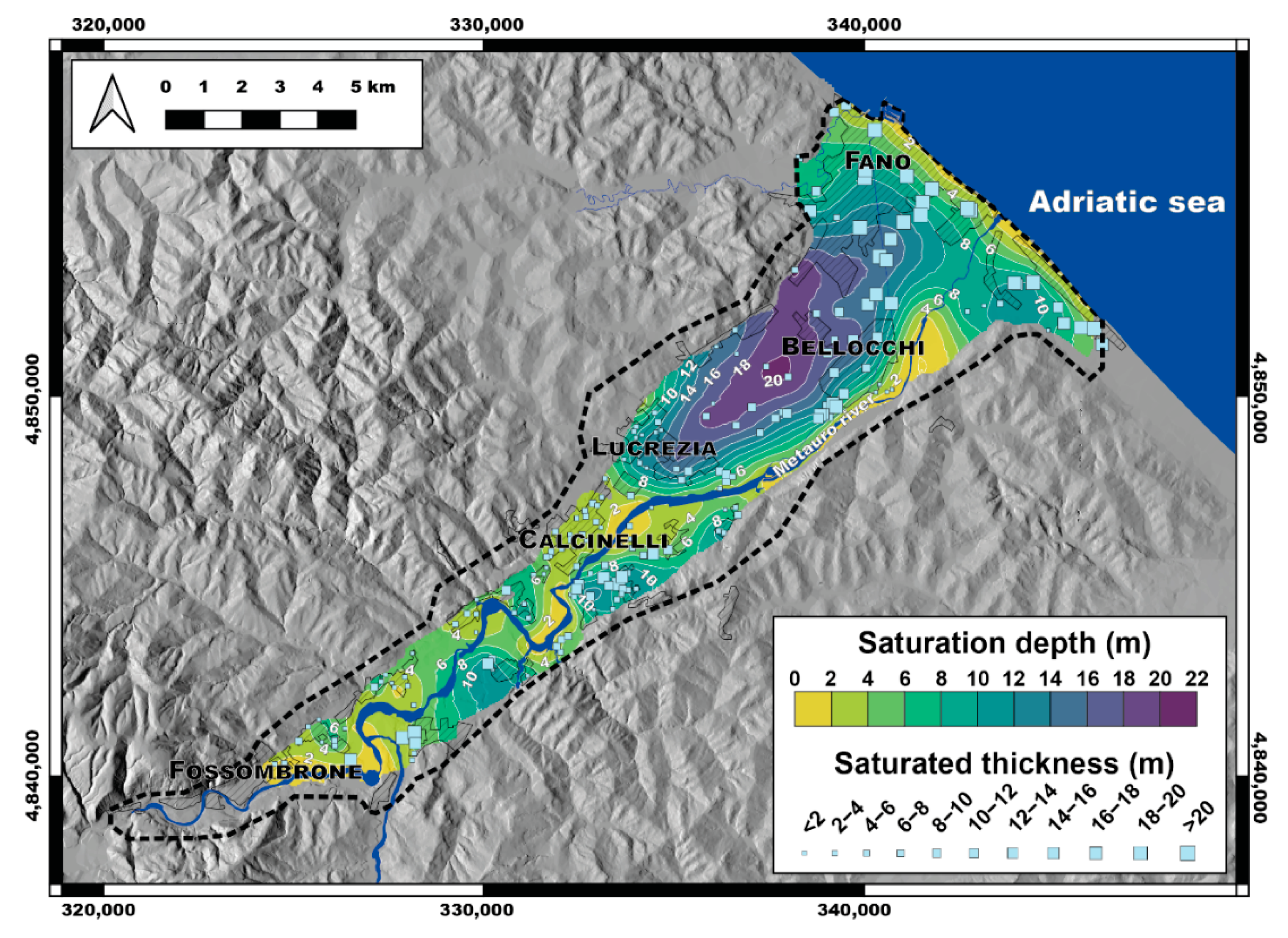
4.3. Saturation Level Depth and Saturated Thickness

The saturation level depth, whose representation was obtained from the Marche Region Water Protection Plan [45], is mapped in Figure 4. The map shows the existence of a superficial saturation level that characterizes the alluvial deposits of the lower Metauro Valley. The saturation depth varies from ~1 m to a maximum of ~20 m from ground level. The minimum levels are found near the coastline, where a marine component seems to be present [36], and in general along the Metauro river, indicating water exchanges between the river and the aquifer [35]. The maximum depths were recorded between Bellocchi and Lucrezia (Figure 4), with an elongated shape of the saturation level in agreement with the paleo-riverbed morphology shown in Figure 3. The low values recorded in the latter area seems to be also correlated to the increasing exploitation rates of water [45]. Regarding the saturated thicknesses, the maximum values (up to ~45 m) are located in the coastal area, where the deeper bedrock and the lower values of the saturation depths are present. Other high values (i.e., up to 20 m) are recorded in those areas where the bedrock is deeper (Figure 3), such as S of Calcinelli and NE of Fossombrone (Figure 4). On the other hand, the lower values of permeated sediments are found in agreement with the deeper saturated depths and at the margins of the valley, where the bedrock has depths lower than 5 m or approaches the surface.

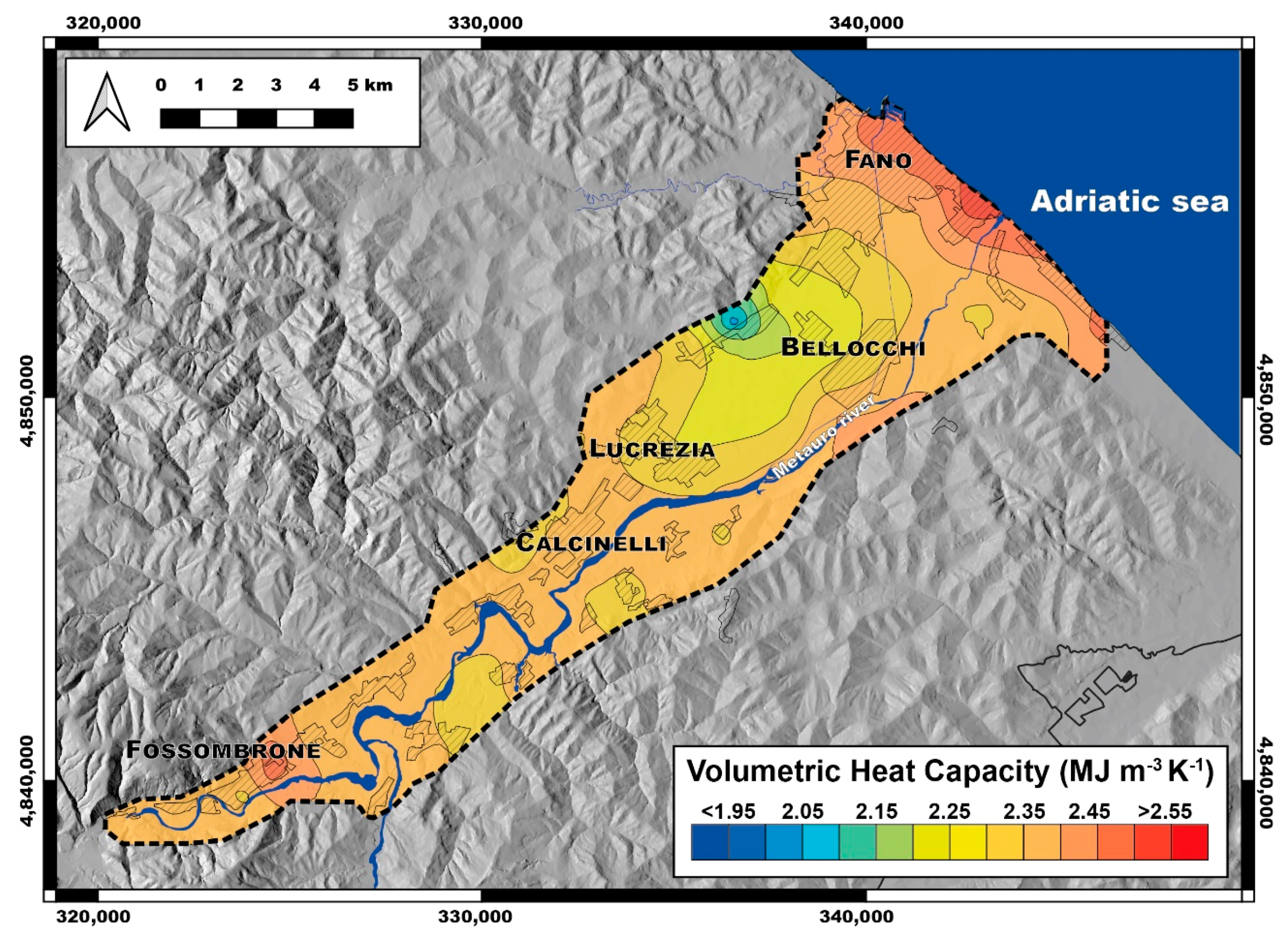
4.4. Thermophysical Properties of the Underground

The thermophysical properties (i.e., λ and SVC) have been defined in detail for each stratigraphic unit using the lithostratigraphic information of the geognostic drillings, the hydrogeological saturation level and the morphology of the bedrock (Figure 3a,b). The results are reported in the maps of the thermal conductivity (Figure 5) and of the volumetric heat capacity (Figure 6).
The values of λ in the lower Metauro Valley range between 1.22 and 2.27 W m−1 K−1, with a mean value of 1.87 W m−1 K−1. Three main areas seem to be outlined from Figure 5, moving from the coast towards the inland: (i) low, (ii) medium, and (iii) high thermal conductivity areas. These differences are mainly driven by the granulometric characters of the sedimentary deposits, the depth and the type of bedrock, the depth of the saturation level and the saturated thickness. Going upriver, from Fano to Lucrezia, λ generally shows relatively low values (<1.80 W m−1 K−1), especially in the central part of Metauro Valley, due to the high thickness of the unconsolidated deposits (Figure 3b), only partially balanced by the saturated condition. In fact, in the Bellocchi area (Figure 5), some of the lowest values of the investigated area are found (<1.70 W m−1 K−1) in correspondence to the deeper saturated level and lower saturated thickness (Figure 4), respectively. In the zone between Lucrezia and Fossombrone (Figure 5), the thermal conductivity is mainly influenced by the type of bedrock, generally represented by the Colombacci Fm. (Figure 1; Table 1). In fact, the average thickness of the sedimentary infill is generally <15 m (Figure 3), thus poorly influencing the weighted λ along the first 100 m from the ground level. Finally, the surroundings of Fossombrone are characterized by the highest values of λ (i.e., >2.00 W m−1 K−1) of the study area because a greater thickness of the carbonatic bedrock with high thermal conductivity is intercepted along the vertical of investigation (Figure 1 and Figure 3; Table 1). The only exception in this latter zone is given by the presence of the Bisciaro Fm., which has the lower λ value among the bedrock formations (Table 1), that defines a narrow low-thermal conductivity zone (Figure 5).
The volumetric heat capacity shows a moderately homogeneous distribution along the whole investigated area (Figure 6). In fact, in most of the lower Metauro Valley, SVC values range between 2.35 and 2.40 MJ m−3 K−1. Three areas differ from this range. Near the coastal zone, the elevated presence of permeated fine grain deposits (sands to clays) give rise to SVC values generally higher than 2.50 MJ m−3 K−1, with a maximum of 2.62 MJ m−3 K−1. An additional area with higher SVC values is near Fossombrone, linked to the outcrops of the Marnoso-Arenacea Fm. (Table 1; Figure 1). The lowest SVC values (i.e., <2.30 MJ m−3 K−1) are found in correspondence of the deepest saturation levels and the lowest saturated thicknesses likely due to the thermal conductivity behavior (Figure 5). It is worth noting that even lower values of SVC (i.e., <1.30 MJ m−3 K−1) are found at the NW margin of the valley, near Bellocchi (Figure 6), closely associated with the outcrops of the Gessoso-Solfifera Fm. (Figure 1), which is characterized by the lowest SVC values of the entire suite of bedrock lithotypes involved in the studied area (Table 1).

5. Heat-Exchange Potential for BHEs

5.1. Specific Heat Extraction

The specific heat extraction values of each lithotype and sediment have been assigned according to the relationship proposed by Viesi et al. [18], and are reported in Table 1. Consequently, the spatial distribution along and across the studied area (Figure 7) is intimately correlated with the λ behaviour reported in Figure 5. The minimum and maximum values calculated on the verticals of investigation are 3.20 and 4.90 kW, respectively, with a mean of 4.19 kW. The area between Fano and Lucrezia shows values generally lower than 4.10 kW, while this value slightly increases up to 4.30 kW moving towards Fossombrone (Figure 7). This latter locality is characterized by the highest (4.90 kW) and the lowest values of the area (3.20 kW), respectively. The higher SHE values derived from the widespread presence of limestone formations (46–49 W m1; Table 1), whereas the lower are found where the Bisciaro Fm. reaches the surface (SHE rate = 33 W m1; Table 1).

5.2. Geothermal Potential

The geothermal potential map (Figure 8) obtained applying the G.POT algorithm [1] defines that the highest capacity to extract heat from the ground is found in the Fossombrone area. In this area, values generally higher than 9.7 MWh y1, with peaks of ~10.7 MWh y1, are observed where geological formations of the Umbria-Marche succession, with relatively high thermal conductivity, are present (Figure 5; Table 1). The presence of outcrops of the Bisciaro Fm. in the Fossombrone surroundings drastically drops down the geothermal potential, resulting in values <8.0 MWh y1. The remaining part of the lower Metauro Valley is characterized by values between ~9.0 and ~9.7 MWh y1, with the lowest potentials located where the thick unsaturated zone above the shallow aquifer is present (i.e., between Fano and Lucrezia) (Figure 8). The geothermal potential is mainly controlled by the thermal conductivity of the lithotypes and the hydrogeological conditions, with the ground temperature being defined through Equation (3) as relatively homogeneous throughout the whole area (12.8–15.1 °C), as well as the values of SVC (Figure 6). In fact, as the whole investigated area belongs to the same climate zone (Climate Zone E) (Figure 2), the parameters related to the BHEs and the system properties used in the G.POT algorithms were taken to be the same for each vertical of investigation (Table 2).

5.3. Depth to Be Drilled for Vertical Closed-Loop BHE Systems

Following the application of Equations (1) and (2), a mean consumption for domestic heating value of 96.3 kWh m2 y1 (considering 2230 DD; Figure 2) and a power demand of ~4.0 kW for a standard domestic environment were defined. Taking this into consideration, the depth to be drilled to supply 4.0 kW was estimated for each investigated point (Figure 9). The drilling depths are in the range between 82 and 125 m, with an average value of 96 m. A general decrease in the depth is required to achieve 4.0 kW, moving from the coastal areas to the inner part of the investigated area (Figure 9), in agreement with the general increase in the thermal conductivity (Figure 5) and specific heat extraction rates (Figure 7) of the limestones forming the bedrock in the inner areas. As the main cost driver for the implementation of BHE is the drilling of the vertical boreholes [2], from an economic point of view, considering a mean cost rate for drilling, indiscriminately for the sedimentary infill or the bedrock, of EUR 50 m1 [2], each drill for supply 4.0 kW can cost between EUR 4100 and 6250, differentiating for about 35%, with a mean cost of EUR ~4800 per borehole. Nevertheless, market competition in the framework of the drilling companies may allow a decrease in the cost down to EUR 37.50 m1 and, therefore, in the investigated area a single drill for a supply of 4.0 kW should range between EUR 3075 and 4687 based on the requested depth of boreholes related to the different geothermal potentials.

6. Summary and Conclusions

In this work, a detailed study of the geological, hydrogeological and thermophysical properties of the subsoil of the lower Metauro sedimentary valley has been carried out using publicly available data only, to shed light on the heat-exchange potential of the area. Four main zones have been identified based on the geothermal potential, calculated by means of the G.POT algorithm [1], which is mainly controlled by the bedrock lithotype and the saturated conditions of the sedimentary infill. The coastal area is characterized by a deep bedrock mainly consisting of clays and silty clays formations (Figure 1) with a medium thermal conductivity (Table 1). In this zone, the elevated thickness of the sedimentary infill (Figure 3), mainly permeated by the phreatic aquifer (Figure 4), generally gives rise to a good geothermal potential (Figure 8), with values in the range of 9.5–10.0 MWh y1. Moving towards the inland (i.e., near Bellocchi; Figure 8), the low saturated thickness of the sedimentary deposits (Figure 4) results in slightly lower values of geothermal potential, between 9.0 and 9.4 MWh y1, in agreement with the lower averaged thermal conductivity calculated on the 100 m depth of the investigated subsoil (Figure 5). The area between Lucrezia and Fossombrone shows medium-to-high geothermal potential (9.5–10.0 MWh y1; Figure 8), mainly controlled by the good thermal conductivity of the bedrock (Table 1), with the sedimentary infill and the saturated thickness restricted to few meters, with a few exceptions of deeper bedrocks (Figure 3 and Figure 4). Finally, the area of Fossombrone, where limestone largely represents the main bedrock lithotype, is characterized by the highest geothermal potential of the investigated zone. In fact, values in the range of 9.5–10.5 have been calculated (Figure 8), with the only exception being areas where the low thermally conductive Bisciaro Fm. (Table 1) approaches the surface (Figure 1). The ground heat-exchange potential calculated for the lower Metauro Valley can be considered a medium-high potential when compared to other areas where G.POT was applied [1,12,14,15]. The different geothermal potentials are also reflected in the depth (from 82 to 125 m) to be drilled in the studied area to reach a 4.0 kW domestic energy demand for a 100 m2 house (Figure 9), with consequent differences in the drilling costs.
We demonstrated that publicly available data can be used to evaluate the heat-exchange potential for heating and cooling through vertical closed-loop BHE systems. This approach can be easily extended to other valleys of the Central Apennines with similar geological and hydrogeological conditions, using the free availability of data derived from the Seismic Microzonation studies. It is worth noting that about 1800 Italian municipalities have, to date, a complete Seismic Microzonation study [21], whose data could be therefore fruitfully used to develop thematic maps of the ground, averaged, e.g., over 100 m of depth, such as: (i) thermal conductivity, (ii) volumetric heat capacity, (iii) specific heat extraction, (iv) estimated depth to be drilled for supply a fixed domestic energy demand and finally, (v) shallow geothermal potential (expressed in MWh y1). Moreover, by limiting the definition of the main thermophysical parameters to the very first meters of subsoil and coupling them with a detailed analysis of the soil cover, this approach can also be extended to the definition of horizontal ground heat exchangers in those places where large areas are made available by the owners of the land. These maps will help instill greater awareness among local decisionmakers about shallow geothermal potential and make them take more robust actions to support heating and cooling systems by means of this renewable. The market of the closed-loop BHE systems coupled with geothermal heat pumps could also benefit from this approach when defining the vertical heat-exchange potential from place to place.

Supplementary Materials

The following are available online at https://www.mdpi.com/1996-1073/14/3/768/s1, Table S1: dataset; Figures S1: semivariograms.

Author Contributions

Conceptualization, M.T. and A.R.; methodology, M.T.; software, M.T.; validation, M.T., W.B., M.G. and A.R.; formal analysis, M.T.; investigation, M.T.; resources, M.T., W.B., M.G. and A.R.; data curation, M.T.; writing—original draft preparation, M.T.; writing—review and editing, M.T. and A.R.; visualization, M.T.; supervision, A.R.; project administration, M.T. and A.R.; funding acquisition, A.R. All authors have read and agreed to the published version of the manuscript.

Funding

This research was funded by the Centro di Ricerca Interuniversitario in Economia del Territorio (CRIET-University of Milano Bicocca) and the Dipartimento di Scienze Pure e Applicate (University of Urbino) through a post-doctoral grant to M.T.

Institutional Review Board Statement

Not applicable.

Informed Consent Statement

Not applicable.

Data Availability Statement

Data can be found in the Supplementary Materials or upon request to the corresponding author.

Acknowledgments

M.T. and A.R. are grateful to Angelo Di Gregorio (University of Milano Bicocca) for encouraging this research. The authors are also grateful to the three anonymous reviewers that helped to improve an early version of the manuscript. Special Issue Editors Alessandro Casasso and Rajandrea Sethi (Polytechnic University of Torino) are also acknowledged for editorial handling.

Conflicts of Interest

The authors declare no conflict of interest. The funders had no role in the design of the study; in the collection, analyses, or interpretation of data; in the writing of the manuscript, or in the decision to publish the results.

References

  1. Casasso, A.; Sethi, R.G. POT: A quantitative method for the assessment and mapping of the shallow geothermal potential. Energy 2016, 106, 765–773. [Google Scholar] [CrossRef]
  2. Gemelli, A.; Mancini, A.; Longhi, S. GIS-based energy-economic model of low temperature geothermal resources: A case study in the Italian Marche region. Renew. Energy 2011, 36, 2474–2483. [Google Scholar] [CrossRef]
  3. Muñoz, M.; Garat, P.; Flores-Aqueveque, V.; Vargas, G.; Rebolledo, S.; Sepúlveda, S.; Daniele, L.; Morata, D.; Parada, M.A. Estimating low-enthalpy geothermal energy potential for district heating in Santiago basin-Chile (33.5 °S). Renew. Energy 2015, 76, 186–195. [Google Scholar] [CrossRef]
  4. Lund, J.W.; Toth, A.N. Direct utilization of geothermal energy 2020 worldwide review. Geothermics 2021, 101915. [Google Scholar] [CrossRef]
  5. Omer, A.M. Ground-source heat pumps systems and applications. Renew. Sustain. Energy Rev. 2008, 12, 344–371. [Google Scholar] [CrossRef]
  6. Lohse, C. Environmental impact by hydrogeothermal energy generation in low-enthalpy regions. Renew. Energy 2018, 128, 509–519. [Google Scholar] [CrossRef]
  7. Bagherian, M.A.; Mehranzamir, K. A comprehensive review on renewable energy integration for combined heat and power production. Energ. Convers. Manag. 2020, 224, 113454. [Google Scholar] [CrossRef]
  8. Lo Russo, S.; Boffa, C.; Civita, M.V. Low-enthalpy geothermal energy: An opportunity to meet increasing energy needs and reduce CO2 and atmospheric pollutant emissions in Piemonte, Italy. Geothermics 2009, 38, 254–262. [Google Scholar] [CrossRef]
  9. Galgaro, A.; Di Sipio, E.; Teza, G.; Destro, E.; De Carli, M.; Chiesa, S.; Zarrella, A.; Emmi, G.; Manzella, A. Empirical modeling of maps of geo-exchange potential for shallow geothermal energy at regional scale. Geothermics 2015, 57, 173–184. [Google Scholar] [CrossRef] [Green Version]
  10. Dalla Santa, G.; Galgaro, A.; Sassi, R.; Cultrera, M.; Scotton, P.; Mueller, J.; Bertermann, D.; Mendrinos, D.; Pasquali, R.; Perego, R.; et al. An updated ground thermal properties database for GSHP applications. Geothermics 2020, 85, 101758. [Google Scholar] [CrossRef]
  11. Piscaglia, F.; Blasi, A.; Del Moro, S.; Polonara, F.; Arteconi, A.; Zanarelli, L.; Renzulli, A. Monitoring of a vertical borehole ground-coupled heat pump system: A case study from a marly-limestone heat reservoir (Urbino, Central Italy). Geothermics 2016, 62, 61–69. [Google Scholar] [CrossRef]
  12. Casasso, A.; Sethi, R. Assessment and mapping of the shallow geothermal potential in the province of Cuneo (Piedmont, NW Italy). Renew. Energ. 2017, 102, 306–315. [Google Scholar] [CrossRef]
  13. Previati, A.; Crosta, G.B. Regional-scale assessment of the thermal potential in a shallow alluvial aquifer system in the Po plain (northern Italy). Geothermics 2021, 90, 101999. [Google Scholar] [CrossRef]
  14. Casasso, A.; Pestotnik, S.; Rajver, D.; Jež, J.; Prestor, J.; Sethi, R. Assessment and mapping of the closed-loop shallow geothermal potential in Cerkno (Slovenia). Energy Proced. 2017, 125, 335–344. [Google Scholar] [CrossRef] [Green Version]
  15. Casasso, A.; Della Valentina, S.; Di Feo, A.F.; Capodaglio, P.; Cavorsin, R.; Guglielminotti, R.; Sethi, R. Ground source heat pumps in Aosta Valley (NW Italy): Assessment of existing systems and planning tools for future installations. Rend. Online Soc. Geol. Ital. 2018, 46, 59–66. [Google Scholar] [CrossRef] [Green Version]
  16. Miglani, S.; Orehounig, K.; Carmeliet, J. A methodology to calculate long-term shallow geothermal energy potential for an urban neighbourhood. Energ. Build. 2018, 159, 462–473. [Google Scholar] [CrossRef] [Green Version]
  17. Sbrana, A.; Marianelli, P.; Pasquini, G.; Costantini, P.; Palmieri, F.; Ciani, V.; Sbrana, M. The integration of 3D modeling and simulation to determine the energy potential of low-temperature geothermal systems in the Pisa (Italy) sedimentary plain. Energies 2018, 11, 1591. [Google Scholar] [CrossRef] [Green Version]
  18. Viesi, D.; Galgaro, A.; Visintainer, P.; Crema, L. GIS-supported evaluation and mapping of the geo-exchange potential for vertical closed-loop systems in an Alpine valley, the case study of Adige Valley (Italy). Geothermics 2018, 71, 70–87. [Google Scholar] [CrossRef]
  19. DPC. Dipartimento della Protezione Civile. Studi di Microzonazione Sismica in Italia. 2019. Available online: www.webms.it (accessed on 20 May 2019).
  20. SITR. Sistema Informativo Territoriale Regionale per la Gestione dei Rischi Naturali. Available online: https://pcrm.qmap.cloud/cs/ (accessed on 20 May 2019).
  21. Moscatelli, M.; Albarello, D.; Scarascia Mugnozza, G.; Dolce, M. The Italian approach to seismic microzonation. Bull. Earthq. Eng. 2020, 18, 5425–5440. [Google Scholar] [CrossRef]
  22. ISTAT. Dati del Censimento della Popolazione e delle Abitazioni 2011 (Italian Population Census). 2019. Available online: http://datiopen.istat.it/ (accessed on 20 September 2020).
  23. Doglioni, C.; Gueguen, E.; Harabaglia, P.; Mongelli, F. On the origin of west-directed subduction zones and applications to the western Mediterranean. In The Mediterranean Basins: Tertiary Extension within the Alpine Orogen; Durand, B., Jolivet, L., Horvath, F., Seranne, M., Eds.; Geological Society of London Special Publications: London, UK, 1999; Volume 156, pp. 541–561. [Google Scholar] [CrossRef]
  24. Barchi, M.R.; Minelli, G.; Pialli, G. The CROP 03 profile: A synthesis of results on deep structures of the northern Apennines. Mem. Soc. Geol. Ital. 1998, 52, 383–400. [Google Scholar]
  25. Savelli, D.; De Donatis, M.; Mazzoli, S.; Nesci, O.; Tramontana, M.; Veneri, F. Evidence of Quaternary faulting in the Metauro River Basin (Northern Marche Apennines). Boll. Soc. Geol. Ital. 2002, 1, 931–937. [Google Scholar]
  26. Deiana, G.; Pialli, G. The structural provinces of the Umbro-Marchean Apennines. Mem. Soc. Geol. Ital. 1994, 48, 473–484. [Google Scholar]
  27. Ciarapica, G.; Passeri, L. The paleographic duplicity of the Apennines. Boll. Soc. Geol. Ital. 2002, 121, 67–75. [Google Scholar]
  28. Della Vedova, B.; Bellani, S.; Pellis, G.; Squarci, P. Deep temperatures and surface heat flow distribution. In Anatomy of an Orogen: The Apennines and Adjacent Mediterranean Basins; Vai, G.B., Martini, P., Eds.; Springer: Dordrecht, The Netherlands, 2001; pp. 65–76. [Google Scholar]
  29. Pauselli, C.; Gola, G.; Mancinelli, P.; Trumpy, E.; Saccone, M.; Manzella, A.; Ranalli, G. A new surface heat flow map of the Northern Apennines between latitudes 42.5 and 44.5 N. Geothermics 2019, 81, 39–52. [Google Scholar] [CrossRef]
  30. Verdoya, M.; Chiozzi, P.; Gola, G. Unravelling the terrestrial heat flow of a young orogen: The example of the northern Apennines. Geothermics 2021, 101993. [Google Scholar] [CrossRef]
  31. Chiodini, G.; Cardellini, C.; Caliro, S.; Chiarabba, C.; Frondini, F. Advective heat transport associated with regional Earth degassing in central Apennine (Italy). Earth Planet. Sci. Lett. 2013, 373, 65–74. [Google Scholar] [CrossRef]
  32. Tavarnelli, E. Structural evolution of a foreland fold-and-thrust belt: The Umbria-Marche Apennines, Italy. J. Struct. Geol. 1997, 19, 523–534. [Google Scholar] [CrossRef]
  33. Di Bucci, D.; Mazzoli, S.; Nesci, O.; Savelli, D.; Tramontana, M.; De Donatis, M.; Borraccini, F. Active deformation in the frontal part of the Northern Apennines: Insights from the lower Metauro River basin area (northern Marche, Italy) and adjacent Adriatic off-shore. J. Geodyn. 2003, 36, 213–238. [Google Scholar] [CrossRef]
  34. Conti, P.; Cornamusini, G.; Carmignani, L. An outline of the geology of the Northern Apennines (Italy), with geological map at 1:250,000 scale. Ital. J. Geosci. 2020, 139, 149–194. [Google Scholar] [CrossRef]
  35. Nanni, T. Le falde di subalveo delle Marche: Inquadramento idrogeologico, qualità delle acque (ed) elementi di neotettonica. In Materiali per la Programmazione 2; Regione Marche: Ancona, Italy, 1985; p. 112. [Google Scholar]
  36. Di Girolamo, M. Analisi delle risorse idriche e valutazione della vulnerabilità, con l’ausilio di metodologie GIS, dell’acquifero alluvionale del fiume Metauro tra Montemaggiore e Fano (PU). Master’s Thesis, University of G. D’Annunzio Chieti and Pescara, Chieti, Italy, 2004; p. 180. [Google Scholar]
  37. Nesci, O.; Savelli, D.; Troiani, F. Evoluzione tardo quaternaria dell’area di foce del Fiume Metauro (Marche settentrionali). In Collana dell’Autorità di Bacino della Basilicata, Proceedings of the “Coste: Prevenire, Programmare, Pianificare Conference”, Maratea, Italy, 15–17 May 2008; Autorità di Bacino della Basilicata: Potenza, Italy, 2008; Volume 9, pp. 443–451. [Google Scholar]
  38. Calderoni, G.; Della Seta, M.; Fredi, P.; Lupia Palmieri, E.; Nesci, O.; Savelli, D.; Troiani, F. Late Quaternary geomorphological evolution of the Adriatic coast reach encompassing the Metauro, Cesano and Misa river mouths (Northern Marche, Italy). Geoacta Spec. Publ. 2010, 3, 109–124. [Google Scholar]
  39. VIDEPI Project. 2009. Available online: www.videpi.com (accessed on 8 June 2019).
  40. Protezione Civile e Sicurezza. Annali Idrologici della Regione March. Available online: https://www.regione.marche.it/Regione-Utile/Protezione-Civile/Progetti-e-Pubblicazioni/Annali-Idrologici (accessed on 10 June 2020).
  41. TCSM. Technical Commission for Seismic Microzonation. Graphic and Data Archiving Standards. Version 4.1; National Department of Civil Protection: Rome, Italy, 2018; Available online: www.centromicrozonazionesismica.it/it/download/send/26-standardms-41/71-standardms-4-1 (accessed on 5 May 2019).
  42. ASTM. Standard test method for classification of soils for engineering purposes. In Annual Book of ASTM Standards—Unified Soil Classification System; ASTM Designation D 2487-83, 04-08; American Society for Testing and Materials: West Conshohocken, PA, USA, 1985; Volume 4, pp. 395–408. [Google Scholar]
  43. Verdoya, M.; Chiozzi, P. Influence of groundwater flow on the estimation of subsurface thermal parameters. Int. J. Earth Sci. 2018, 107, 137–144. [Google Scholar] [CrossRef]
  44. ASET. Studio Idrogeologico Sul Fondovalle del Fiume Metauro per L’Utilizzo E/O IL Recupero per USI Potabili Della Falda Dell’Acquifero Alluvionale; ASET: Fano, Italy, 2010. [Google Scholar]
  45. Regione Marche. Piano Tutela Acque. 2002. Available online: https://www.regione.marche.it/Regione-Utile/Ambiente/Tutela-delle-acque/PTA#Documentazione (accessed on 8 September 2019).
  46. Chicco, J.; Verdoya, M.; Giuli, G.; Invernizzi, C. Thermophysical properties and mineralogical composition of the Umbria-Marche carbonate succession (central Italy). In 250 Million Years of Earth History in Central Italy: Celebrating 25 Years of the Geological Observatory of Coldigioco; Koeberl, C., Bice, D.M., Eds.; Geological Society of America: Boulder, CO, USA, 2019; Volume 542, pp. 59–67. [Google Scholar] [CrossRef] [Green Version]
  47. Blasi, A. Aspetti Geologici del Geoscambio: Test Termici, Profili di Temperatura e Monitoraggio della Geotermia a Bassa Entalpia. Ph.D. Thesis, University of Urbino Carlo Bo, Urbino, Italy, 2012; p. 170. [Google Scholar]
  48. Blasi, A.; Menichetti, M. Conducibilità termica distribuita da un test di risposta termica (TRT) su una sonda geotermica. Acque Sotter. Ital. J. Groundw. 2012, 3, 33–41. [Google Scholar]
  49. Verdoya, M.; Pacetti, C.; Chiozzi, P.; Invernizzi, C. Thermophysical parameters from laboratory measurements and in-situ tests in borehole heat exchangers. Appl. Eng. 2018, 144, 711–720. [Google Scholar] [CrossRef]
  50. VDI 4640. German Guidelines: Thermal Use of the Underground. 2001. Available online: https://www.antpedia.com/standard/6266555-8.html (accessed on 10 November 2020).
  51. Di Sipio, E.; Galgaro, A.; Destro, E.; Teza, G.; Chiesa, S.; Giaretta, A.; Manzella, A. Subsurface thermal conductivity assessment in Calabria (southern Italy): A regional case study. Environ. Earth Sci. 2014, 72, 1383–1401. [Google Scholar] [CrossRef]
  52. Andújar Márquez, J.M.; Martínez Bohórquez, M.A.; Gómez Melgar, S. Ground thermal diffusivity calculation by direct soil temperature measurement. Application to very low enthalpy geothermal energy systems. Sensors 2016, 16, 306. [Google Scholar] [CrossRef] [PubMed] [Green Version]
  53. Signorelli, S.; Kohl, T. Regional ground surface temperature mapping from meteorological data. Glob. Planet. Chang. 2004, 40, 267–284. [Google Scholar] [CrossRef]
  54. Tarquini, S.; Isola, I.; Favalli, M.; Battistini, A. TINITALY, a Digital Elevation Model of Italy with a 10 m-Cell Size (Version 1.0) [Data set]; Istituto Nazionale di Geofisica e Vulcanologia (INGV): Milano, Italy, 2007. [Google Scholar] [CrossRef]
  55. Presidential Decree. DPR 26 Agosto 1993, n. 412. Regolamento Recante Norme per la Progettazione, L’installazione, L’esercizio e la Manutenzione Degli Impianti Termici Degli Edifici ai Fini del Contenimento dei Consumi di Energia. 1993. Available online: https://www.gazzettaufficiale.it/eli/id/1993/10/14/093G0451/sg (accessed on 15 July 2020).
  56. Luce e Gas Italia. Available online: https://luceegasitalia.it/ (accessed on 10 November 2020).
Figure 1. (a) Simplified geological map of the lower Metauro Valley and surrounding areas with the main cities (modified after Conti et al. [34]); (b) surface heat flow map of central-eastern Italy with 10 mW m−2 isolines; black squares indicate the wells, white circles the cities and the blue ellipse the study area (modified after Pauselli et al. [29]); (c) schematic stratigraphic sequence and lithologies obtained from four deep boreholes of the Visibility of Petroleum Exploration data in Italy (VIDEPI) project [39].
Energies 14 00768 g001
Figure 2. (a) Climate zones of Italy as defined by the Presidential Decree [55] (modified from [56]); (b) location of the five meteorological stations located in, or near, the study area; (c) mean temperatures of recorded by the five meteorological stations for the 2009–2019 period.
Energies 14 00768 g002
Figure 3. (a) Bedrock depth and location of the geognostic drillings and outcrops; (b) topographic profile (exaggerated vertical scale) and schematic relationship between the sedimentary bedrock and the alluvial Quaternary deposits along the Metauro Valley. The total thickness considered is 100 m.
Energies 14 00768 g003
Figure 4. Saturation depth of the alluvial aquifer and saturated thickness of the sedimentary deposits.
Energies 14 00768 g004
Figure 5. Map of the estimated thermal conductivity of the ground averaged over 100 m of depth from the surface.
Energies 14 00768 g005
Figure 6. Map of the estimated volumetric heat capacity of the ground averaged over 100 m of depth from the surface.
Energies 14 00768 g006
Figure 7. Map of the estimated specific heat extraction for 100 m depth boreholes.
Energies 14 00768 g007
Figure 8. Map of the estimated geothermal potential for the study area.
Energies 14 00768 g008
Figure 9. Map of the estimated depth to be drilled for supply a fixed domestic energy demand of 4.0 kW.
Energies 14 00768 g009
Table 1. Thermophysical properties for unconsolidated sediments and rocks of the investigated area.
Thermal Conductivity λ (W m−1 K−1)Specific Heat Extraction 2400 h (W m−1) *Volumetric Heat Capacity
(MJ m−3 K−1) §
Sediment CategoryMin
Value
Max
Value
Recommended ValueReferences
Gravel dry0.400.900.40[50]241.6
Gravel water-saturated1.602.501.80[50]412.4
Sand and gravel moisture dry0.500.900.50[51]251.6
Sand and gravel moisture
Water-saturated
1.603.002.20[51]482.7
Sand dry0.300.900.40[50]241.6
Sand water-saturated2.003.002.40[50]522.9
Clay/silt dry0.401.000.50[50]251.6
Clay/silt water-saturated1.103.101.70[50,51]393.4
Lithotype
Argille Azzurre Fm.--1.91[46]422.4
Colombacci Fm.--1.96[47]432.4
San Donato Fm.--1.96[47]432.4
Gessoso Solfifera Fm.1.152.801.60[50]371.2
Tripoli Fm.--1.96[47]432.4
Marnoso-Arenacea Fm.--2.10[48]462.6
Schlier Fm.2.012.342.18[46,49]472.5
Bisciaro Fm.1.301.351.32[46,47]332.4
Sc. Cinerea Fm.2.102.112.10[46]462.5
Sc. Bianca-Rossa-Variegata Fms.1.822.632.09[46,47]462.4
Marne a Fucoidi Fm.--2.28[46]492.5
Maiolica Fm.2.002.672.27[46,47]492.4
* Based on the relationship proposed by Viesi et al. [18]—SHE (2400 h) = 3.34λ2 + 4.54λ + 21.63. § Values after Andujar Marquez et al. [52].
Table 2. Closed-loop borehole heat exchanger (BHE) systems and heat-exchange parameters used in the Geothermal POTential (G.POT) algorithm.
ParameterValueUnit
Minimum fluid temperature−2°C
Borehole depth100m
Borehole radius0.075m
Borehole thermal resistance0.1mK W−1
Simulated lifetime50years
Publisher’s Note: MDPI stays neutral with regard to jurisdictional claims in published maps and institutional affiliations.

