
Deep Geothermal Heating Potential for the Communities of the Western Canadian Sedimentary Basin


Abstract
1. Introduction
2. Background
3. Structural Setting of the WCSB
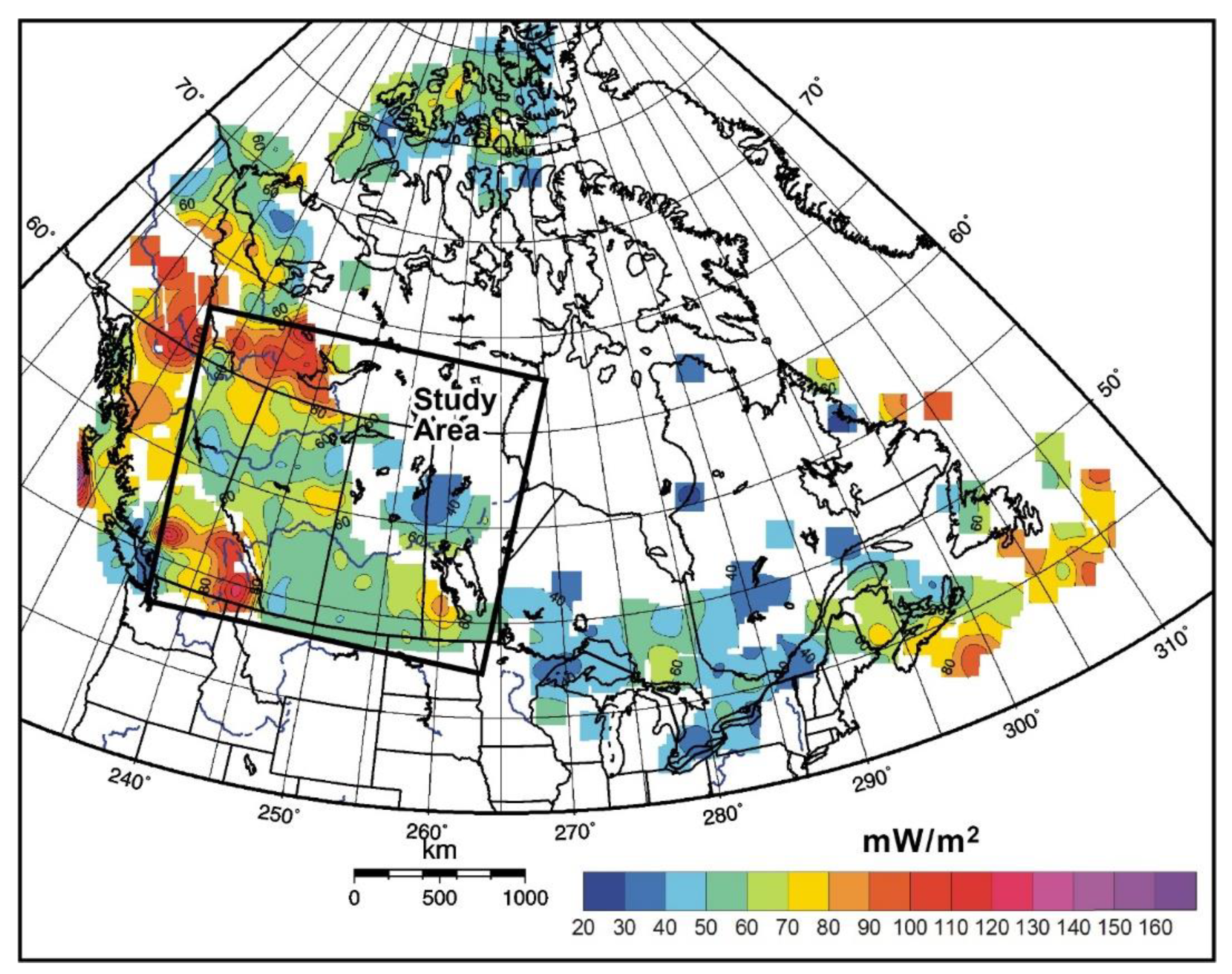
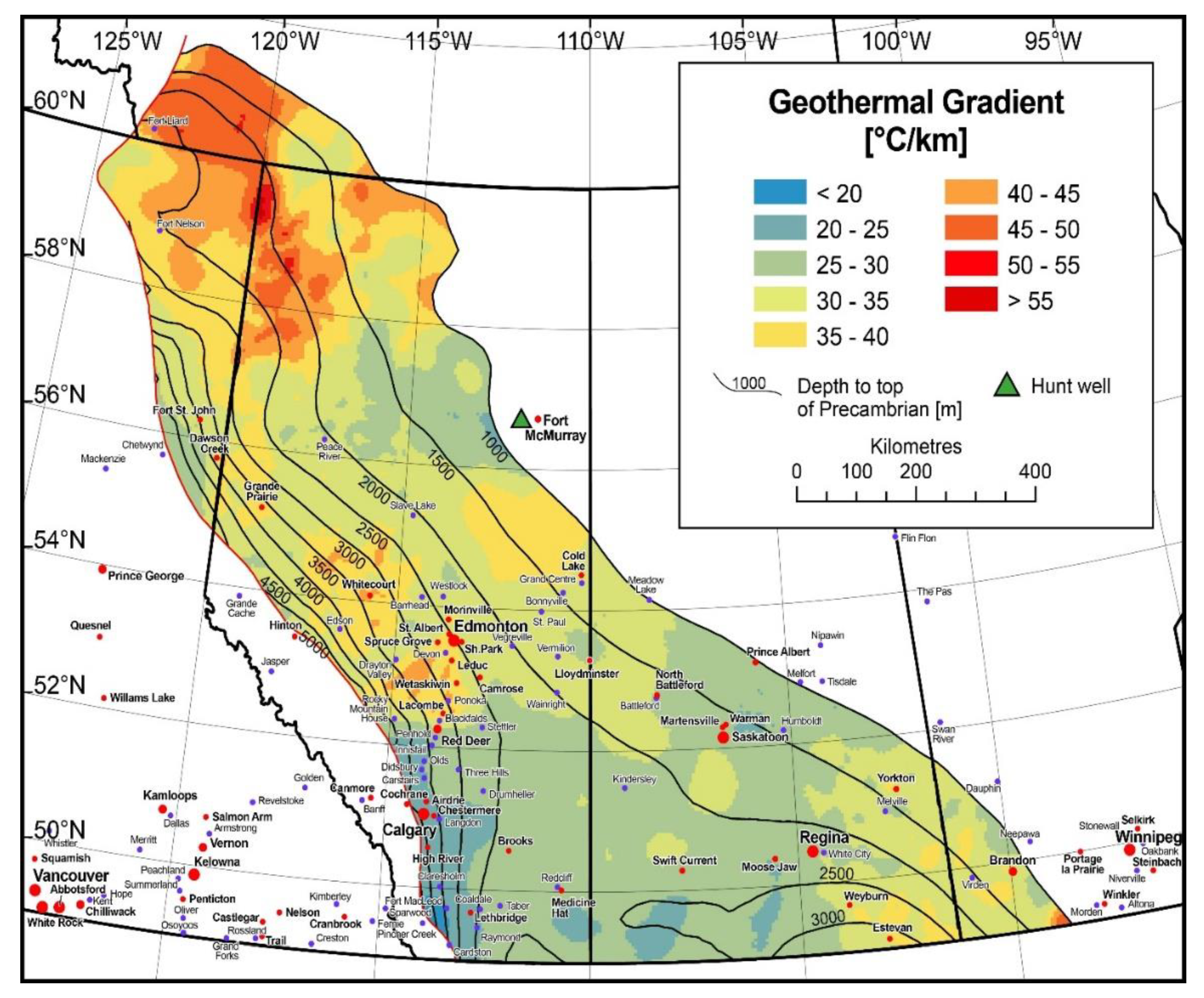
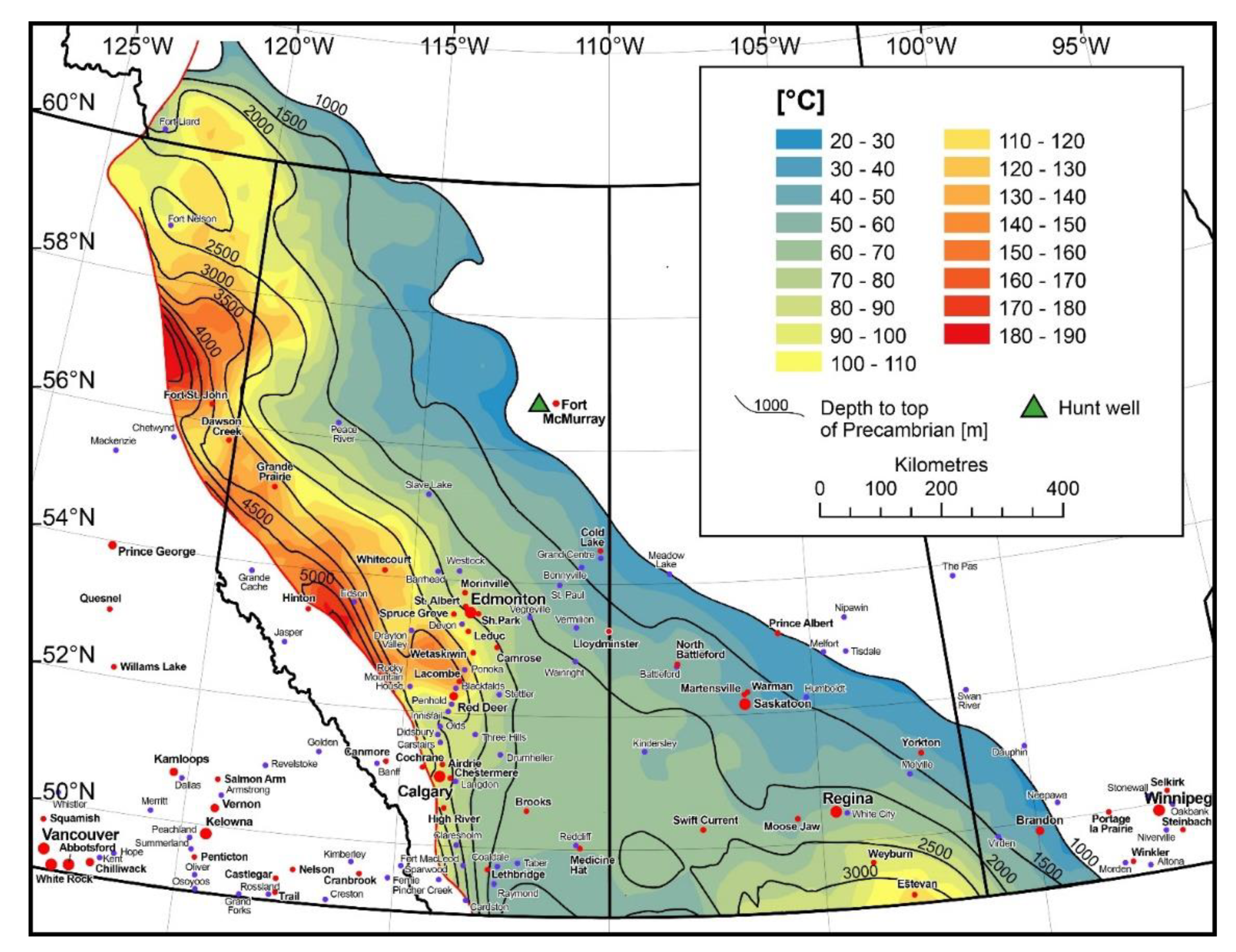
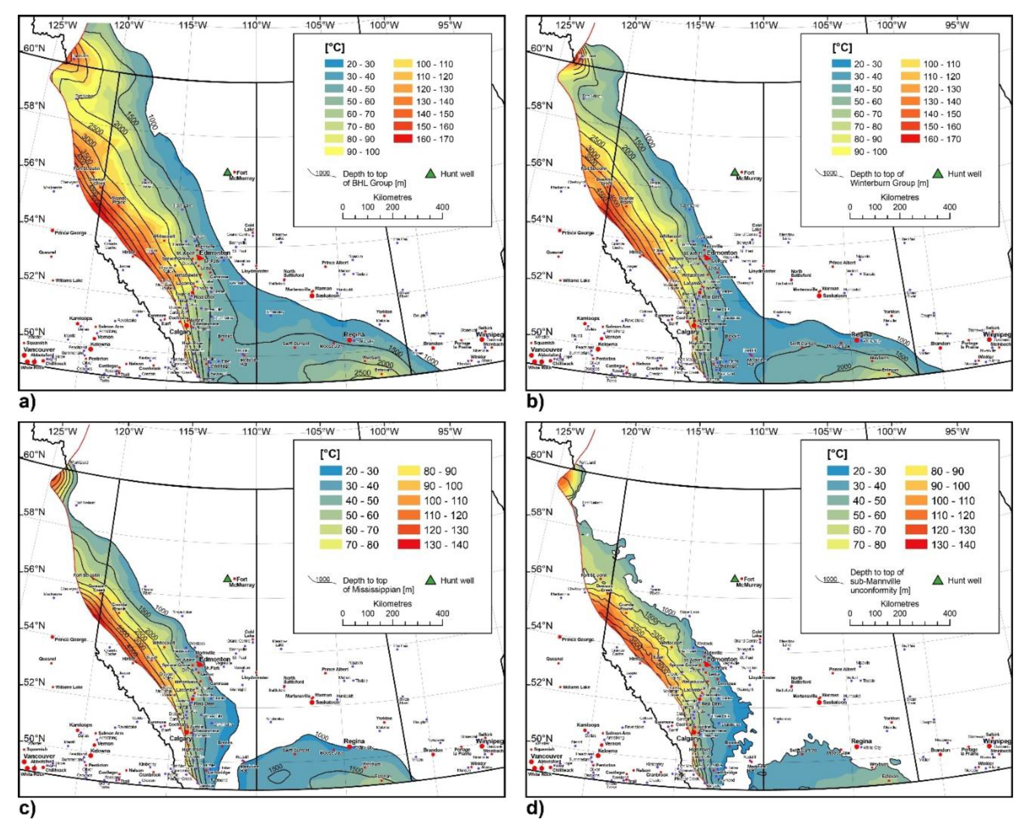
4. Geothermal Gradient and Maximum Temperatures—WCSB
5. Geothermal Energy Calculation
6. WCSB Prospects—Summary
7. Discussion of Results
- Very low enthalpy gain <80 kJ/kg—aquifer,
- Low to Medium enthalpy (80–200) kJ/kg—Geothermal heat prospects with uplift by heat pumps
- Medium enthalpy prospects (200–320) kJ/kg—Prospects for direct deep aquifer source based geothermal heating.
- High enthalpy (320–520 kJ/kg)—Very good direct heat prospects, marginal EGS geothermal electrical power prospects.
- Very high enthalpy (>520 kJ/kg)—Electrical power and direct heating prospects.
8. Conclusions
Author Contributions
Funding
Institutional Review Board Statement
Informed Consent Statement
Data Availability Statement
Acknowledgments
Conflicts of Interest
Appendix A


Appendix B


Appendix C

| City Location | Province | Temperature T | Energy 1 | Energy 2 | Energy 3 | Energy 4 | Households | Households | Power | Power | Enthalpy Gain | Formation Group | Depth |
|---|---|---|---|---|---|---|---|---|---|---|---|---|---|
| at C = 3993 | at C = 3150 | at C = 3993 | at C = 3150 | Minimum | Maximum | at C = 3993 | at C = 3150 | at C = 3993 | |||||
| at 30 kg/s | at 30 kg/s | at 80 kg/s | at 80 kg/s | number | number | at 30 kg/s | at 80 kg/s | ||||||
| Name | Name | °C | GJ Year | GJ Year | GJ Year | GJ Year | @ 130 GJ/Year | @ 130 GJ/Year | MW el. | MW el. | kJ/kg | km | |
| Airdrie | AB | 90 | 66,110 | 52,153 | 176,293 | 139,074 | 401 | 1356 | 0.5 | 0.8 | 280 | M. Cambrian Basal Sands. | 3.7 |
| Banff | AB | ? | _ | _ | _ | _ | _ | _ | _ | _ | _ | Disturbed belt | ? |
| Barrhead | AB | 83.2 | 51,125 | 40,331 | 136,333 | 107,550 | 310 | 1049 | 0.4 | 0.6 | 252 | M. Cambrian Basal Sands. | 2.6 |
| Battleford | Sask. | 51 | _ | _ | _ | _ | _ | _ | _ | _ | 124 | M. Cambrian Basal Sands. | 1.7 |
| Beaumont | AB | 90 | 66,110 | 52,153 | 176,293 | 139,074 | 401 | 1356 | 0.5 | 0.8 | 280 | M. Cambrian Basal Sands. | 2.6 |
| Blackfalds | AB | 120.25 | 132,770 | 104,740 | 354,054 | 279,306 | 806 | 2723 | 0.8 | 1.5 | 400 | M. Cambrian Basal Sands. | 3.25 |
| Bonnyville | AB | 49 | _ | _ | _ | _ | _ | _ | _ | _ | 116 | M. Cambrian Basal Sands. | 1.4 |
| Brooks | AB | 70 | 22,037 | 17,384 | 58,764 | 46,358 | 134 | 452 | 0.2 | 0.3 | 200 | M. Cambrian Basal Sands. | 2.4 |
| Calgary | AB | 100 | 88,146 | 69,537 | 235,057 | 185,432 | 535 | 1808 | 0.6 | 1.0 | 319 | M. Cambrian Basal Sands. | 3.8 |
| Camrose | AB | 80 | 44,073 | 34,768 | 117,528 | 92,716 | 267 | 904 | 0.4 | 0.5 | 240 | M. Cambrian Basal Sands. | 2.4 |
| Canmore | AB | 40 | _ | _ | _ | _ | _ | _ | _ | _ | 80 | RM Def. f. | _ |
| Cardston | AB | 70 | 22,037 | 17,384 | 58,764 | 46,358 | 134 | 452 | 0.2 | 0.3 | 200 | Disturbed belt fm | 3.5 |
| Carstairs | AB | 90 | 66,110 | 52,153 | 176,293 | 139,074 | 401 | 1356 | 0.5 | 0.8 | 280 | M. Cambrian Basal Sands. | 3.6 |
| Chestermere | AB | 90 | 66,110 | 52,153 | 176,293 | 139,074 | 401 | 1356 | 0.5 | 0.8 | 280 | M. Cambrian Basal Sands. | 3.7 |
| Claresholm | AB | 75.6 | 34,377 | 27,119 | 91,672 | 72,318 | 209 | 705 | 0.3 | 0.4 | 222 | M. Cambrian Basal Sands. | 3.6 |
| Coaldale | AB | 62.5 | 5509 | 4346 | 14,691 | 11,589 | 33 | 113 | 0.1 | 0.1 | 170 | M. Cambrian Basal Sands. | 2.5 |
| Cochrane | AB | 100 | 88,146 | 69,537 | 235,057 | 185,432 | 535 | 1808 | 0.6 | 1.0 | 319 | M. Cambrian Basal Sands. | 4.1 |
| Cold Lake | AB | 42 | _ | _ | _ | _ | _ | _ | _ | _ | 88 | M. Cambrian Basal Sands. | 1.2 |
| Cold Lake | AB | 40 | _ | _ | _ | _ | _ | _ | _ | _ | 80 | M. Cambrian Basal Sands. | 1.2 |
| Dawson Creek | NE BC | 137 | 168,580 | 132,989 | 449,546 | 354,638 | 1023 | 3458 | 1.0 | 1.9 | 465 | M. Cambrian Basal Sands. | 3.9 |
| Devon | AB | 99.9 | 87,926 | 69,363 | 234,469 | 184,968 | 534 | 1804 | 0.6 | 1.0 | 319 | M. Cambrian Basal Sands. | 2.7 |
| Didsbury | AB | 92.5 | 71,619 | 56,499 | 190,984 | 150,663 | 435 | 1469 | 0.5 | 0.8 | 289 | M. Cambrian Basal Sands. | 3.7 |
| Drayton Valley | AB | 119 | 130,016 | 102,567 | 346,709 | 273,512 | 789 | 2667 | 0.8 | 1.5 | 395 | M. Cambrian Basal Sands. | 3.4 |
| Drumheller | AB | 72.9 | 28,427 | 22,426 | 75,806 | 59,802 | 173 | 583 | 0.3 | 0.3 | 211 | M. Cambrian Basal Sands. | 2.7 |
| E. Lloydminster | Sask. | 51 | _ | _ | _ | _ | _ | _ | _ | _ | 124 | M. Cambrian Basal Sands. | 1.7 |
| Edmonton | AB | 90 | 66,110 | 52,153 | 176,293 | 139,074 | 401 | 1356 | 0.5 | 0.8 | 280 | M. Cambrian Basal Sands. | 2.5 |
| Edson | AB | 147 | 191,718 | 151,243 | 511,248 | 403,314 | 1163 | 3933 | 1.2 | 2.2 | 507 | M. Cambrian Basal Sands. | 4.2 |
| Estevan | Sask. | 115 | 121,642 | 95,961 | 324,378 | 255,896 | 738 | 2495 | 0.8 | 1.4 | 380 | U. Cambrian Deadwood | 3.2 |
| Fort Liard | NWT | 170 | 242,402 | 191,226 | 646,406 | 509,937 | 1471 | 4972 | 1.4 | 2.8 | 599 | M. Cambrian Basal Sands. | 4.25 |
| Fort Nelson | NE BC | 104 | 96,961 | 76,491 | 258,562 | 203,975 | 588 | 1989 | 0.6 | 1.1 | 335 | M. Cambrian Basal Sands. | 2.6 |
| Fort Sask. | AB | 90 | 66,110 | 52,153 | 176,293 | 139,074 | 401 | 1356 | 0.5 | 0.8 | 280 | M. Cambrian Basal Sands. | 2.4 |
| Fort St. John | NE BC | 128 | 149,849 | 118,213 | 399,596 | 315,234 | 909 | 3074 | 0.9 | 1.7 | 431 | M. Cambrian Basal Sands. | 4 |
| Grand Centre | AB | 40.5 | _ | _ | _ | _ | _ | _ | _ | _ | 82 | M. Cambrian Basal Sands. | 1.35 |
| Grande Cache | AB | ? | _ | _ | _ | _ | _ | _ | _ | _ | _ | Disturbed belt fm | ? |
| Grande Prairie | AB | 140 | 176,293 | 139,074 | 470,113 | 370,863 | 1070 | 3616 | 1.1 | 2.0 | 479 | Granite Wash | 3.7 |
| High River | AB | 100 | 88,146 | 69,537 | 235,057 | 185,432 | 535 | 1808 | 0.6 | 1.0 | 319 | M. Cambrian Basal Sands. | 4 |
| Hinton | AB | 170 | 242,402 | 191,226 | 646,406 | 509,937 | 1471 | 4972 | 1.4 | 2.8 | 599 | M. Cambrian Basal Sands. | 5.6 |
| Humboldt | Sask. | 35 | _ | _ | _ | _ | _ | _ | _ | _ | 60 | M. Cambrian Basal Sands. | 1.4 |
| Innisfail | AB | 87.5 | 60,601 | 47,807 | 161,602 | 127,484 | 368 | 1243 | 0.4 | 0.7 | 270 | M. Cambrian Basal Sands. | 3.5 |
| Jasper | AB | ? | _ | _ | _ | _ | _ | _ | _ | _ | _ | Disturbed belt | ? |
| Kindersley | Sask. | 59 | _ | _ | _ | _ | _ | _ | _ | _ | 157 | M. Cambrian Basal Sands. | 2.2 |
| Lacombe | AB | 120 | 132,219 | 104,305 | 352,585 | 278,148 | 802 | 2712 | 0.8 | 2.0 | 399 | M. Cambrian Basal Sands. | 3.2 |
| Langdon | AB | 80.5 | 45,175 | 35,638 | 120,467 | 95,034 | 274 | 927 | 0.4 | 0.5 | 242 | M. Cambrian Basal Sands. | 3.5 |
| Leduc | AB | 110 | 110,183 | 86,921 | 293,821 | 231,790 | 669 | 2260 | 0.7 | 2.0 | 359 | M. Cambrian Basal Sands. | 2.7 |
| Lethbridge | AB | 70 | 22,037 | 17,384 | 58,764 | 46,358 | 134 | 452 | 0.2 | 0.3 | 200 | M. Cambrian Basal Sands. | 2.7 |
| Lloydminster | AB | 50 | _ | _ | _ | _ | _ | _ | _ | _ | 120 | M. Cambrian Basal Sands. | 1.7 |
| Malville | Sask. | 48 | _ | _ | _ | _ | _ | _ | _ | _ | 112 | M. Cambrian Basal Sands. | 1.6 |
| Martensville | Sask. | 45 | _ | _ | _ | _ | _ | _ | _ | _ | 98 | M. Cambrian Basal Sands. | 1.65 |
| Meadow Lake | Sask. | 35 | _ | _ | _ | _ | _ | _ | _ | _ | 60 | M. Cambrian Basal Sands. | 1 |
| Medicine Hat | AB | 60 | _ | _ | _ | _ | _ | _ | 0.1 | _ | 160 | M. Cambrian Basal Sands. | 2.2 |
| Melford | Sask. | 30 | _ | _ | _ | _ | _ | _ | _ | _ | 40 | M. Cambrian Basal Sands. | 1 |
| Moose Jaw | Sask. | 55 | _ | _ | _ | _ | _ | _ | 0.1 | _ | 140 | M. Cambrian Basal Sands. | 2.2 |
| Morinville | AB | 100 | 88,146 | 69,537 | 235,057 | 185,432 | 535 | 1808 | 0.6 | 1.0 | 319 | M. Cambrian Basal Sands. | 2.4 |
| North Battleford | Sask. | 50 | _ | _ | _ | _ | _ | _ | _ | _ | 118 | M. Cambrian Basal Sands. | 1.65 |
| Olds | AB | 90 | 66,110 | 52,153 | 176,293 | 139,074 | 401 | 1356 | 0.5 | 0.8 | 280 | M. Cambrian Basal Sands. | 3.6 |
| Peace River | AB | 67.2 | 15,866 | 12,517 | 42,310 | 33,378 | 96 | 325 | 0.2 | 0.2 | 188 | Devonian Granite Wash | 2.1 |
| Penhold | AB | 95.2 | 77,569 | 61,192 | 206,850 | 163,180 | 471 | 1591 | 0.5 | 0.9 | 300 | M. Cambrian Basal Sands. | 3.4 |
| Pincher Creek | AB | 89.3 | 64,567 | 50,936 | 172,179 | 135,829 | 392 | 1324 | 0.5 | 0.7 | 277 | Disturbed belt fm | 4.7 |
| Ponoka | AB | 123 | 138,830 | 109,521 | 370,214 | 292,055 | 842 | 2848 | 0.9 | 1.6 | 411 | M. Cambrian Basal Sands. | 3 |
| Prince Albert | Sask. | 30 | _ | _ | _ | _ | _ | _ | _ | _ | 40 | M. Cambrian Basal Sands. | 1 |
| Raymond | AB | 57.5 | _ | _ | _ | _ | _ | _ | _ | _ | 150 | M. Cambrian Basal Sands. | 2.5 |
| Red Deer | AB | 115 | 121,201 | 95,613 | 323,203 | 254,969 | 735 | 2486 | 0.8 | 1.4 | 379 | M. Cambrian Basal Sands. | 3.3 |
| Redcliff | AB | 60.5 | 1102 | 869 | 2938 | 2318 | 7 | 23 | 0.1 | 0.0 | 162 | M. Cambrian Basal Sands. | 2.2 |
| Regina | Sask. | 61 | 1983 | 1565 | 5289 | 4172 | 12 | 41 | 0.1 | 0.0 | 163 | U. Cambrian Deadwood | 2.1 |
| Rocky Mountain House | AB | 144 | 185,107 | 146,027 | 493,619 | 389,407 | 1123 | 3797 | 1.1 | 2.1 | 495 | M. Cambrian Basal Sands. | 4.8 |
| Saskatoon | Sask. | 48 | _ | _ | _ | _ | _ | _ | _ | _ | 110 | M. Cambrian Basal Sands. | 1.7 |
| Slave Lake | AB | 73.5 | 29,749 | 23,469 | 79,332 | 62,583 | 181 | 610 | 0.3 | 0.3 | 214 | M. Cambrian Basal Sands. | 2.1 |
| Spruce Grove | AB | 90 | 66,110 | 52,153 | 176,293 | 139,074 | 401 | 1356 | 0.5 | 0.8 | 280 | M. Cambrian Basal Sands. | 2.6 |
| St. Albert | AB | 90 | 66,110 | 52,153 | 176,293 | 139,074 | 401 | 1356 | 0.5 | 0.8 | 280 | M. Cambrian Basal Sands. | 2.5 |
| St. Paul | AB | 55.25 | _ | _ | _ | _ | _ | _ | _ | _ | 141 | M. Cambrian Basal Sands. | 1.7 |
| Stettler | AB | 78.3 | 40,327 | 31,813 | 107,538 | 84,835 | 245 | 827 | 0.3 | 0.5 | 233 | M. Cambrian Basal Sands. | 2.7 |
| Stony Plain | AB | 90 | 66,110 | 52,153 | 176,293 | 139,074 | 401 | 1356 | 0.5 | 0.8 | 280 | M. Cambrian Basal Sands. | 2.6 |
| Swift Current | Sask. | 65 | 10,578 | 8344 | 28,207 | 22,252 | 64 | 217 | 0.2 | 0.1 | 179 | M. Cambrian Basal Sands. | 2.4 |
| Taber | AB | 59.4 | _ | _ | _ | _ | _ | _ | _ | _ | 157 | M. Cambrian Basal Sands. | 2.2 |
| Three Hills | AB | 80.6 | 45,395 | 35,811 | 121,054 | 95,497 | 275 | 931 | 0.4 | 0.5 | 242 | M. Cambrian Basal Sands. | 3.1 |
| Varman | Sask. | 43 | _ | _ | _ | _ | _ | _ | _ | _ | 93 | M. Cambrian Basal Sands. | 1.6 |
| Vegreville | AB | 64 | 8815 | 6954 | 23,506 | 18,543 | 53 | 181 | 0.2 | 0.1 | 176 | M. Cambrian Basal Sands. | 2 |
| Vermilion | AB | 55.8 | _ | _ | _ | _ | _ | _ | _ | _ | 143 | M. Cambrian Basal Sands. | 1.8 |
| Virden | Man. | 56 | _ | _ | _ | _ | _ | _ | _ | _ | 144 | M. Cambrian Basal Sands. | 1.6 |
| Wainwleft | AB | 64 | 8815 | 6954 | 23,506 | 18,543 | 53 | 181 | 0.2 | 0.1 | 176 | M. Cambrian Basal Sands. | 2 |
| Westlock | AB | 73.6 | 29,970 | 23,643 | 79,919 | 63,047 | 182 | 615 | 0.3 | 0.3 | 214 | M. Cambrian Basal Sands. | 2.3 |
| Wetaskiwin | AB | 110 | 110,183 | 86,921 | 293,821 | 231,790 | 669 | 2260 | 0.7 | 1.3 | 359 | M. Cambrian Basal Sands. | 2.7 |
| Weyburn | Sask. | 92 | 70,076 | 55,282 | 186,870 | 147,418 | 425 | 1437 | 0.5 | 0.8 | 287 | U. Cambrian Deadwood | 2.7 |
| White City | Sask. | 65 | 9916 | 7823 | 26,444 | 20,861 | 60 | 203 | 0.2 | 0.1 | 178 | U. Cambrian Deadwood | 2.15 |
| Whitecourt | AB | 140 | 176,293 | 139,074 | 470,113 | 370,863 | 1070 | 3616 | 1.1 | 2.0 | 479 | M. Cambrian Basal Sands. | 3.3 |
| Yorkton | Sask. | 46 | _ | _ | _ | _ | _ | _ | _ | _ | 102 | M. Cambrian Basal Sands. | 1.3 |
| City Location | Province | Temperature T | Energy 1 | Energy 2 | Energy 3 | Energy 4 | Households | Households | Power | Power | Enthalpy Gain | Formation Group | Depth |
|---|---|---|---|---|---|---|---|---|---|---|---|---|---|
| at C = 3993 | at C = 3150 | at C = 3993 | at C = 3150 | Minimum | Maximum | at C = 3993 | at C = 3150 | at C = 3993 | |||||
| at 30 kg/s | at 30 kg/s | at 80 kg/s | at 80 g/s | number | number | at 30 kg/s | at 80 kg/s | ||||||
| Name | Name | °C | GJ Year | GJ Year | GJ Year | GJ Year | @ 130 GJ/Year | @ 130 GJ/Year | MW el. | MW el. | kJ/kg | km | |
| Airdrie | AB | 80 | 44,073.14 | 34,768.44 | 117,528.4 | 92,715.84 | 267.4495 | 904.0643 | 0.35937 | 0.504 | 239.58 | /Leduc | 1.9 |
| Banff | AB | ? | _ | _ | _ | _ | _ | _ | _ | _ | Disturbed belt | ? | |
| Barrhead | AB | 59.2 | _ | _ | _ | _ | _ | _ | _ | _ | 156.5256 | U. Devonian Beaverhill L. | 1.85 |
| Battleford | Sask. | _ | _ | _ | _ | _ | _ | _ | _ | _ | _ | _ | _ |
| Beaumont | AB | 60 | _ | _ | _ | _ | _ | _ | _ | _ | 159.72 | Beaverhill l. Group | 1.7 |
| Blackfalds | AB | 85 | 55,091.42 | 43,460.55 | 146,910.5 | 115,894.8 | 334.3119 | 1130.08 | _ | 0.63 | 259.545 | U. Devonian Beaverhill L. | 2.5 |
| Bonnyville | AB | _ | _ | _ | _ | _ | _ | _ | _ | _ | _ | Shallow basin | |
| Brooks | AB | 50 | _ | _ | _ | _ | _ | _ | _ | _ | 119.79 | Beaverhill l. Group | 1.7 |
| Calgary | AB | 80 | 44,073.14 | 34,768.44 | 117,528.4 | 92,715.84 | 267.4495 | 904.0643 | 0.35937 | 0.504 | 239.58 | /Leduc | 3.4 |
| Camrose | AB | 60 | _ | _ | _ | _ | _ | _ | 0.11979 | _ | 159.72 | Beaverhill l. Group | 1.6 |
| Canmore | AB | _ | _ | _ | _ | _ | _ | _ | _ | _ | _ | Disturbed belt | _ |
| Cardston | AB | 66 | 13,221.94 | 10,430.53 | 35,258.51 | 27,814.75 | 80.23486 | 271.2193 | _ | _ | 183.678 | U. Devonian Beaverhill L. | 3.3 |
| Carstairs | AB | 75.6 | 34,377.05 | 27,119.38 | 91,672.12 | 72,318.36 | 208.6106 | 705.1702 | _ | _ | 222.0108 | Leduc F. | 3.15 |
| Chestermere | AB | 75 | 33,054.85 | 26,076.33 | 88,146.27 | 69,536.88 | 200.5872 | 678.0483 | _ | _ | 219.615 | /Leduc | 3 |
| Claresholm | AB | 70.35 | 22,807.85 | 17,992.67 | 60,820.93 | 47,980.45 | 138.4051 | 467.8533 | _ | _ | 201.0476 | U. Devonian Beaverhill L. | 3.35 |
| Coaldale | AB | 47.5 | _ | _ | _ | _ | _ | _ | _ | _ | 109.8075 | U. Devonian Beaverhill L. | 1.9 |
| Cochrane | AB | _ | _ | _ | _ | _ | _ | _ | _ | _ | _ | Disturbed belt | _ |
| Cold Lake | AB | _ | _ | _ | _ | _ | _ | _ | _ | _ | _ | Shallow basin | _ |
| Cold Lake | AB | _ | _ | _ | _ | _ | _ | _ | _ | _ | _ | Shallow basin | _ |
| Dawson Creek | NE BC | 126 | 145,441.4 | 114,735.9 | 387,843.6 | 30,5962.3 | 882.5835 | 2983.412 | 0.910404 | 1.6632 | 423.258 | U. Devonian Beaverhill L. | 3.6 |
| Devon | AB | 72.2 | 26,884.61 | 21,208.75 | 71,692.3 | 56,556.66 | 163.1442 | 551.4793 | _ | _ | 208.4346 | Cooking Lk F. | 1.9 |
| Didsbury | AB | 78.75 | 41,318.57 | 32,595.41 | 110,182.8 | 86,921.1 | 250.7339 | 847.5603 | _ | _ | 234.5888 | Leduc F. | 3.15 |
| Drayton Valley | AB | 86.8 | 59,058 | 46,589.71 | 157,488 | 124,239.2 | 358.3824 | 1211.446 | _ | 0.67536 | 266.7324 | U. Devonian Beaverhill L. | 2.8 |
| Drumheller | AB | 51.3 | _ | _ | _ | _ | _ | _ | _ | _ | 124.9809 | Leduc F. | 1.9 |
| E.Lloydminster | Sask. | _ | _ | _ | _ | _ | _ | _ | _ | _ | _ | _ | _ |
| Edmonton | AB | 70 | 22,036.57 | 17,384.22 | 58,764.18 | 46,357.92 | 133.7248 | 452.0322 | _ | _ | 199.65 | Beaverhill l. Group | 1.7 |
| Edson | AB | 126 | 145,441.4 | 114,735.9 | 387,843.6 | 30,5962.3 | 882.5835 | 2983.412 | 0.910404 | 1.6632 | 423.258 | Beaverhill l. Group | 3.6 |
| Estevan | Sask. | 82.8 | 50,243.38 | 39,636.02 | 133,982.3 | 105,696.1 | 304.8925 | 1030.633 | 0.392911 | 0.57456 | 250.7604 | U. Devonian Beaverhill L. | 2.3 |
| Fort Liard | NWT | 136 | 167,477.9 | 132,120.1 | 446,607.8 | 352,320.2 | 1016.308 | 3435.445 | 1.030194 | 1.9152 | 463.188 | U. Devonian Beaverhill L. | 3.4 |
| Fort Nelson | NE BC | 84 | 52,887.76 | 41,722.13 | 141,034 | 111,259 | 320.9394 | 1084.877 | _ | 0.6048 | 255.552 | U. Devonian Beaverhill L. | 2.1 |
| Fort Sask. | AB | 60 | _ | _ | _ | _ | _ | _ | _ | _ | 159.72 | Beaverhill l. Group | 1.6 |
| Fort St. John | NE BC | 112 | 114,590.2 | 90,397.94 | 305,573.7 | 241,061.2 | 695.3688 | 2350.567 | 0.742698 | 1.3104 | 367.356 | U. Devonian Beaverhill L. | 3.5 |
| Grand Centre | AB | _ | _ | _ | _ | _ | _ | _ | _ | Shallow basin | _ | ||
| Grande Cache | AB | _ | _ | _ | _ | _ | _ | _ | _ | Disturbed belt | _ | ||
| Grande Prairie | AB | 90 | 66,109.71 | 52,152.66 | 176,292.5 | 139,073.8 | 401.1743 | 1356.097 | 0.47916 | 0.756 | 279.51 | /Leduc | 3.5 |
| High River | AB | 80 | 44,073.14 | 34,768.44 | 117,528.4 | 92,715.84 | 267.4495 | 904.0643 | 0.35937 | 0.504 | 239.58 | Beaverhill l. Group | 3.5 |
| Hinton | AB | 160 | 220,365.7 | 173,842.2 | 587,641.8 | 463,579.2 | 1337.248 | 4520.322 | 1.31769 | 2.52 | 559.02 | /Leduc | 3.4−5.4 |
| Humboldt | Sask. | _ | _ | _ | _ | _ | _ | _ | _ | _ | _ | _ | _ |
| Innisfail | AB | 68.75 | 19,282 | 15,211.19 | 51,418.66 | 40,563.18 | 117.0092 | 395.5282 | _ | _ | 194.6588 | U. Devonian Beaverhill L. | 2.75 |
| Jasper | AB | _ | _ | _ | _ | _ | _ | _ | _ | _ | _ | Disturbed belt | |
| Kindersley | Sask. | 32.4 | _ | _ | _ | _ | _ | _ | _ | _ | 49.5132 | U. Devonian Beaverhill L. | 1.2 |
| Lacombe | AB | 130 | 154,256 | 121,689.5 | 411,349.3 | 324,505.4 | 936.0734 | 3164.225 | 0.95832 | 1.764 | 439.23 | Beaverhill l. Group | 2.3 |
| Langdon | AB | 69.6 | 21,155.11 | 16,688.85 | 56,413.62 | 44,503.6 | 128.3758 | 433.9509 | _ | _ | 198.0528 | Leduc F. | 2.9 |
| Leduc | AB | 80 | 44,073.14 | 34,768.44 | 117,528.4 | 92,715.84 | 267.4495 | 904.0643 | _ | 0.504 | 239.58 | Beaverhill l. Group | 1.9 |
| Lethbridge | AB | 60 | _ | _ | _ | _ | _ | _ | _ | _ | 159.72 | Beaverhill l. Group | 2.3 |
| Lloydminster | AB | _ | _ | _ | _ | _ | _ | _ | _ | _ | _ | Shallow basin | _ |
| Malville | Sask. | _ | _ | _ | _ | _ | _ | _ | _ | _ | _ | Shallow basin | _ |
| Martensville | Sask. | _ | _ | _ | _ | _ | _ | _ | _ | _ | _ | Shallow basin | _ |
| Meadow Lake | Sask. | _ | _ | _ | _ | _ | _ | _ | _ | _ | _ | Shallow basin | _ |
| Medicine Hat | AB | 50 | _ | _ | _ | _ | _ | _ | _ | _ | 119.79 | Beaverhill l. Group | 1.6 |
| Melford | Sask. | _ | _ | _ | _ | _ | _ | _ | _ | _ | _ | _ | _ |
| Moose Jaw | Sask. | 37.5 | _ | _ | _ | _ | _ | _ | _ | _ | 69.8775 | U. Devonian Beaverhill L. | 1.5 |
| Morinville | AB | 70 | 22,036.57 | 17,384.22 | 58,764.18 | 46,357.92 | 133.7248 | 452.0322 | _ | _ | 199.65 | /Cooking Lk F. | 1.6 |
| North Battleford | Sask. | _ | _ | _ | _ | _ | _ | _ | _ | _ | _ | Shallow basin | _ |
| Olds | AB | 76.25 | 35,809.42 | 28,249.36 | 95,491.8 | 75,331.62 | 217.3028 | 734.5523 | _ | _ | 224.6063 | Leduc F. | 3.05 |
| Peace River | AB | 67.2 | 15,866.33 | 12,516.64 | 42,310.21 | 33,377.7 | 96.28183 | 325.4632 | _ | _ | 188.4696 | Leduc F. | 2.1 |
| Penhold | AB | 70.2 | 22,477.3 | 17,731.9 | 59,939.47 | 47,285.08 | 136.3993 | 461.0728 | _ | _ | 200.4486 | U. Devonian Beaverhill L. | 2.6 |
| Pincher Creek | AB | _ | _ | _ | _ | _ | _ | _ | _ | _ | Disturbed belt | _ | |
| Ponoka | AB | 88 | 61,702.39 | 48,675.82 | 164,539.7 | 129,802.2 | 374.4294 | 1265.69 | _ | 0.7056 | 271.524 | U. Devonian Beaverhill L. | 2.2 |
| Prince Albert | Sask. | _ | _ | _ | _ | _ | _ | _ | _ | _ | _ | Shallow basin | _ |
| Raymond | AB | _ | 111.804 | U. Devonian Beaverhill L. | 2 | ||||||||
| Red Deer | AB | 90 | 66,109.71 | 52,152.66 | 176,292.5 | 139,073.8 | 401.1743 | 1356.097 | _ | 0.756 | 279.51 | /Leduc F. to SE | 2.6 |
| Redcliff | AB | 45.375 | _ | _ | _ | _ | _ | _ | _ | _ | 101.3224 | U. Devonian Beaverhill L. | 1.65 |
| Regina | Sask. | 42 | _ | _ | _ | _ | _ | _ | _ | _ | 87.846 | U. Devonian Beaverhill L. | 1.4 |
| Rocky Mountain House | AB | 108.5 | 106,877.4 | 84,313.47 | 285,006.3 | 224,835.9 | 648.5651 | 2192.356 | 0.700772 | 1.2222 | 353.3805 | U. Devonian Beaverhill L. | 3.5 |
| Saskatoon | Sask. | _ | _ | _ | _ | _ | _ | _ | _ | _ | _ | Shallow basin | _ |
| Slave Lake | AB | 54.4 | _ | _ | _ | _ | _ | _ | _ | _ | 137.3592 | U. Devonian Beaverhill L. | 1.6 |
| Spruce Grove | AB | 70 | 22,036.57 | 17,384.22 | 58,764.18 | 46,357.92 | 133.7248 | 452.0322 | _ | _ | 199.65 | Beaverhill l. Group | 1.9 |
| St. Albert | AB | 60 | _ | _ | _ | _ | _ | _ | _ | _ | 159.72 | /Cooking Lk F. | 1.7 |
| St. Paul | AB | _ | _ | _ | _ | _ | _ | _ | _ | −79.86 | Shallow basin | _ | |
| Stettler | AB | 55.5 | _ | _ | _ | _ | _ | _ | _ | _ | 141.7515 | Leduc F. | 1.85 |
| Stony Plain | AB | 70 | 22,036.57 | 17,384.22 | 58,764.18 | 46,357.92 | 133.7248 | 452.0322 | _ | _ | 199.65 | Beaverhill l. Group | 2 |
| Swift Current | Sask. | 45.9 | _ | _ | _ | _ | _ | _ | _ | _ | 103.4187 | U. Devonian Beaverhill L. | 1.7 |
| Taber | AB | 45.9 | _ | _ | _ | _ | _ | _ | _ | _ | 103.4187 | U. Devonian Beaverhill L. | 1.7 |
| Three Hills | AB | 59.8 | _ | _ | _ | _ | _ | _ | _ | _ | 158.9214 | U. Devonian Beaverhill L. | 2.3 |
| Varman | Sask. | _ | _ | _ | _ | _ | _ | _ | _ | _ | _ | Shallow basin | _ |
| Vegreville | AB | 35.2 | _ | _ | _ | _ | _ | _ | _ | _ | 60.6936 | U. Devonian Beaverhill L. | 1.1 |
| Vermilion | AB | _ | _ | _ | _ | _ | _ | _ | _ | _ | Shallow basin | _ | |
| Virden Man. | Man. | _ | _ | _ | _ | _ | _ | _ | _ | _ | _ | Shallow basin | _ |
| Wainwright | AB | 33.6 | _ | _ | _ | _ | _ | _ | _ | _ | 54.3048 | U. Devonian Beaverhill L. | 1.05 |
| Westlock | AB | 51.2 | _ | _ | _ | _ | _ | _ | _ | _ | 124.5816 | U. Devonian Beaverhill L. | 1.6 |
| Wetaskiwin | AB | 80 | 44,073.14 | 34,768.44 | 117,528.4 | 92,715.84 | 267.4495 | 904.0643 | _ | _ | 239.58 | Beaverhill l. Group | 2 |
| Weyburn | Sask. | 66.3 | 13,883.04 | 10,952.06 | 37,021.43 | 29,205.49 | 84.2466 | 284.7803 | _ | _ | 184.8759 | U. Devonian Beaverhill L. | 1.95 |
| White City | Sask. | 42 | _ | _ | _ | _ | _ | _ | _ | _ | 87.846 | U. Devonian Beaverhill L. | 1.4 |
| Whitecourt | AB | 110 | 110,182.8 | 86,921.1 | 293,820.9 | 231,789.6 | 668.6238 | 2260.161 | 0.71874 | 1.26 | 359.37 | Swan H. - Slave Pt | 2.7 |
| Yorkton | Sask. | _ | _ | _ | _ | _ | _ | _ | _ | _ | _ | Shallow basin | _ |
| City Location | Province | Temperature T | Energy 1 | Energy 2 | Energy 3 | Energy 4 | Households | Households | Power | Power | Enthalpy Gain | Formation Group | Depth |
|---|---|---|---|---|---|---|---|---|---|---|---|---|---|
| at C = 3993 | at C = 3150 | at C = 3993 | at C = 3150 | Minimum | Maximum | at C = 3993 | at C = 3150 | at C = 3993 | top of Winterburn Group | ||||
| at 30 kg/s | at 30 kg/s | at 80 kg/s | at 80 kg/s | number | number | at 30 kg/s | at 80 kg/s | ||||||
| Name | Name | °C | GJ Year | GJ Year | GJ Year | GJ Year | @ 130 GJ/Year | @ 130 GJ/Year | MW el. | MW el. | kJ/kg | km | |
| Airdrie | AB | 70 | 22,036.57 | 17,384.22 | 58,764.18 | 46,357.92 | 133.7248 | 452.0322 | 0.23958 | 0.252 | 199.65 | /Dolomite Nisku | 2.9 |
| Banff | AB | _ | _ | _ | _ | _ | _ | _ | _ | _ | _ | Disturbed belt | _ |
| Barrhead | AB | 44.8 | _ | _ | _ | _ | _ | _ | _ | _ | 99.0264 | Wabamum dolomite | 1.4 |
| Battleford | Sask. | _ | _ | _ | _ | _ | _ | _ | _ | _ | _ | Shallow basin | _ |
| Beaumont | AB | 50 | _ | _ | _ | _ | _ | _ | _ | _ | 119.79 | Wabamum dolomite | 1.3 |
| Blackfalds | AB | 73.1 | 28,867.9 | 22,773.33 | 76,981.08 | 60,728.88 | 175.1794 | 592.1621 | 0.276715 | 0.33012 | 212.0283 | Dolomite Nisku | 2.15 |
| Bonnyville | AB | _ | _ | _ | _ | _ | _ | _ | _ | _ | _ | Shallow basin | _ |
| Brooks | AB | 40 | _ | _ | _ | _ | _ | _ | _ | _ | 79.86 | Winterburn/Wabamun | 1.4 |
| Calgary | AB | 70 | 22,036.57 | 17,384.22 | 58,764.18 | 46,357.92 | 133.7248 | 452.0322 | 0.23958 | 0.252 | 199.65 | /Dolomite Nisku | 3 |
| Camrose | AB | 50 | _ | _ | _ | _ | _ | _ | _ | _ | 119.79 | /Dolomite Nisku | 1.3 |
| Canmore | AB | _ | _ | _ | _ | _ | _ | _ | _ | _ | _ | Shallow basin | _ |
| Cardston | AB | 60 | _ | _ | _ | _ | _ | _ | _ | _ | 159.72 | top of Winterburn Group | 3 |
| Carstairs | AB | 68.4 | 18,510.72 | 14,602.74 | 49,361.91 | 38,940.65 | 112.3288 | 379.707 | 0.220414 | 0.21168 | 193.2612 | Dolimite Nisku | 2.85 |
| Chestermere | AB | 70 | 22,036.57 | 17,384.22 | 58,764.18 | 46,357.92 | 133.7248 | 452.0322 | 0.23958 | 0.252 | 199.65 | /Dolomite Nisku | 2.8 |
| Claresholm | AB | 60.9 | 1983.291 | 1564.58 | 5288.776 | 4172.213 | 12.03523 | 40.6829 | 0.130571 | 0.02268 | 163.3137 | top of Winterburn Group | 2.9 |
| Coaldale | AB | _ | _ | _ | _ | _ | _ | _ | _ | _ | 79.86 | top of Winterburn Group | 1.6 |
| Cochrane | AB | _ | _ | _ | _ | _ | _ | _ | _ | _ | _ | Shallow basin | _ |
| Cold Lake | AB | Shallow basin | _ | ||||||||||
| Cold Lake | AB | _ | _ | _ | _ | _ | _ | _ | _ | _ | _ | Shallow basin | _ |
| Dawson Creek | NE BC | 131.25 | 157,010.5 | 123,862.6 | 418,694.8 | 330,300.2 | 952.789 | 3220.729 | 0.973294 | 1.7955 | 444.2213 | top of Winterburn Group | 3.75 |
| Devon | AB | 57 | 147.741 | Wabamum dolomite | 1.5 | ||||||||
| Didsbury | AB | 70 | 22,036.57 | 17,384.22 | 58,764.18 | 46,357.92 | 133.7248 | 452.0322 | 0.23958 | 0.252 | 199.65 | Dolomite Nisku | 2.8 |
| Drayton Valley | AB | 72 | 26,443.88 | 20,861.06 | 70,517.02 | 55,629.5 | 160.4697 | 542.4386 | 0.263538 | 0.3024 | 207.636 | Wabamum dolomite | 2.4 |
| Drumheller | AB | 45.9 | _ | _ | _ | _ | _ | _ | _ | _ | 103.4187 | Dolomite Nisku | 1.7 |
| E.Lloydminster | Sask. | 0 | _ | _ | _ | _ | _ | _ | _ | _ | _ | Shallow basin | _ |
| Edmonton | AB | 50 | _ | _ | _ | _ | _ | _ | _ | _ | 119.79 | /Dolomite Nisku | 1.2 |
| Edson | AB | 112 | 114,590.2 | 90,397.94 | 305,573.7 | 241,061.2 | 695.3688 | 2350.567 | 0.742698 | 1.3104 | 367.356 | top of Winterburn Group | 3.2 |
| Estevan | Sask. | 77.4 | 38,343.63 | 30,248.54 | 102,249.7 | 80,662.78 | 232.6811 | 786.536 | 0.328225 | 0.43848 | 229.1982 | top of Winterburn Group | 2.15 |
| Fort Liard | NWT | 132 | 158,663.3 | 125,166.4 | 423,102.1 | 333,777 | 962.8183 | 3254.632 | 0.982278 | 1.8144 | 447.216 | top of Winterburn Group | 3.3 |
| Fort Nelson | NE BC | 56 | _ | _ | _ | _ | _ | _ | 0.071874 | _ | 143.748 | top of Winterburn Group | 1.4 |
| Fort Sask. | AB | 40 | _ | _ | _ | _ | _ | _ | _ | _ | 79.86 | /Dolomite Nisku | 1.1 |
| Fort St. John | NE BC | 112 | 114,590.2 | 90,397.94 | 305,573.7 | 241,061.2 | 695.3688 | 2350.567 | 0.742698 | 1.3104 | 367.356 | top of Winterburn Group | 3.5 |
| Grand Centre | AB | _ | _ | _ | _ | _ | _ | _ | _ | _ | _ | Shallow basin | _ |
| Grande Cache | AB | _ | _ | _ | _ | _ | _ | _ | _ | _ | _ | Disturbed belt | _ |
| Grande Prairie | AB | 130 | 154,256 | 121,689.5 | 411,349.3 | 324,505.4 | 936.0734 | 3164.225 | 0.95832 | 1.764 | 439.23 | /Limestone Nisku | 3.4 |
| High River | AB | 80 | 44,073.14 | 34,768.44 | 117,528.4 | 92,715.84 | 267.4495 | 904.0643 | 0.35937 | 0.504 | 239.58 | Winterburn/Wabamun | 3.3 |
| Hinton | AB | 150 | 198,329.1 | 156,458 | 528,877.6 | 417,221.3 | 1203.523 | 4068.29 | 1.1979 | 2.268 | 519.09 | /Dolomite Nisku | 3.7−5.2 |
| Humboldt | Sask. | 0 | _ | _ | _ | _ | _ | _ | _ | _ | _ | Shallow basin | _ |
| Innisfail | AB | _ | _ | _ | _ | _ | _ | _ | _ | _ | _ | Shallow basin | _ |
| Jasper | AB | _ | Disturbed belt | _ | |||||||||
| Kindersley | Sask. | _ | _ | _ | _ | _ | _ | _ | _ | _ | _ | Shallow basin | _ |
| Lacombe | AB | 80 | 44,073.14 | 34,768.44 | 117,528.4 | 92,715.84 | 267.4495 | 904.0643 | 0.35937 | 0.504 | 239.58 | /Dolomite Nisku | 2 |
| Langdon | AB | 62.4 | 5288.776 | 4172.213 | 14,103.4 | 11,125.9 | 32.09394 | 108.4877 | 0.14854 | 0.06048 | 169.3032 | Dolomite Nisku | 2.6 |
| Leduc | AB | 60 | _ | _ | _ | _ | _ | _ | 0.11979 | _ | 159.72 | Wabamum dolomite | 1.5 |
| Lethbridge | AB | 50 | _ | _ | _ | _ | _ | _ | _ | _ | 119.79 | Winterburn/Wabamun | 1.9 |
| Lloydminster | AB | _ | _ | _ | _ | _ | _ | _ | _ | _ | _ | Shallow basin | _ |
| Martensville | Sask. | _ | _ | _ | _ | _ | _ | _ | _ | _ | _ | Shallow basin | _ |
| Meadow Lake | Sask. | _ | _ | _ | _ | _ | _ | _ | _ | _ | _ | Shallow basin | _ |
| Medicine Hat | Sask. | 40 | _ | _ | _ | _ | _ | _ | _ | _ | _ | Winterburn/Wabamun | 1.3 |
| Melford | AB | _ | _ | _ | _ | _ | _ | _ | _ | _ | _ | Shallow basin | _ |
| Melville | Sask. | _ | _ | _ | _ | _ | _ | _ | _ | _ | _ | Shallow basin | _ |
| Moose Jaw | Sask. | 32.5 | _ | _ | _ | _ | _ | _ | _ | _ | 49.9125 | top of Winterburn Group | 1.3 |
| Morinville | AB | 50 | _ | _ | _ | _ | _ | _ | _ | _ | 119.79 | Wabamum dolomite | 1.2 |
| North Battleford | Sask. | _ | _ | _ | _ | _ | _ | _ | _ | _ | _ | Shallow basin | _ |
| Olds | AB | 67.5 | 16,527.43 | 13,038.17 | 44,073.14 | 34,768.44 | 100.2936 | 339.0241 | 0.209633 | 0.189 | 189.6675 | Dolomite Nisku | 2.7 |
| Peace River | AB | 56 | 143.748 | top of Winterburn Group | 1.75 | ||||||||
| Penhold | AB | 62.1 | 4627.679 | 3650.686 | 12,340.48 | 9735.163 | 28.0822 | 94.92676 | 0.144946 | 0.05292 | 168.1053 | top of Winterburn Group | 2.3 |
| Pincher Creek | AB | _ | _ | _ | _ | _ | _ | _ | _ | _ | _ | Disturbed belt | _ |
| Ponoka | AB | 72 | 26,443.88 | 20,861.06 | 70,517.02 | 55,629.5 | 160.4697 | 542.4386 | 0.263538 | 0.3024 | 207.636 | Winterburn/Dolomite Nisku | 1.8 |
| Prince Albert | Sask. | _ | _ | _ | _ | _ | _ | _ | _ | _ | _ | Shallow basin | _ |
| Raymond | AB | 42 | _ | _ | _ | _ | _ | _ | _ | _ | _ | top of Winterburn Group | 1.75 |
| Red Deer | AB | 70 | 22,036.57 | 17,384.22 | 58,764.18 | 46,357.92 | 133.7248 | 452.0322 | 0.23958 | 0.252 | 199.65 | /Dolomite Nisku | 2.2 |
| Redcliff | AB | 34.375 | 57.39938 | top of Winterburn Group | 1.25 | ||||||||
| Regina | Sask. | 39 | _ | _ | _ | _ | _ | _ | _ | _ | 75.867 | top of Winterburn Group | 1.3 |
| Rocky Mountain House | AB | 93 | 72,720.68 | 57,367.93 | 193,921.8 | 152,981.1 | 441.2917 | 1491.706 | 0.515097 | 0.8316 | 291.489 | Wabamum dolomite | 3.1 |
| Saskatoon | Sask. | 0 | _ | _ | _ | _ | _ | _ | _ | _ | _ | Shallow basin | _ |
| Slave Lake | AB | 37.4 | _ | _ | _ | _ | _ | _ | _ | _ | 69.4782 | Dolomite Nisku | 1.1 |
| Spruce Grove | AB | 60 | _ | _ | _ | _ | _ | _ | 0.11979 | _ | 159.72 | Wabamum dolomite | 1.6 |
| St. Albert | AB | 50 | _ | _ | _ | _ | _ | _ | _ | _ | 119.79 | Wabamum dolomite | 1.3 |
| St. Paul | AB | _ | _ | _ | _ | _ | _ | _ | _ | _ | _ | Shallow basin | _ |
| Stettler | AB | 43.5 | _ | 93.8355 | top of Winterburn Group | 1.5 | |||||||
| Stony Plain | AB | 60 | _ | _ | _ | _ | _ | _ | 0.11979 | _ | 159.72 | Wabamum dolomite | 1.5 |
| Swift Current | Sask. | 40.5 | _ | _ | _ | _ | _ | _ | _ | _ | 81.8565 | top of Winterburn Group | 1.5 |
| Taber | AB | 37.8 | _ | _ | _ | _ | _ | _ | _ | _ | 71.0754 | top of Winterburn Group | 1.4 |
| Three Hills | AB | 50.7 | _ | _ | _ | _ | _ | _ | _ | _ | 122.5851 | Dolimite Nisku | 1.95 |
| Vegreville | AB | _ | _ | _ | _ | _ | _ | _ | _ | _ | _ | Shallow basin | _ |
| Vermilion | AB | 0 | _ | _ | _ | _ | _ | _ | _ | _ | _ | Shallow basin | _ |
| Virden Man. | Man. | 0 | _ | _ | _ | _ | _ | _ | _ | _ | _ | Shallow basin | _ |
| Wainwright | AB | 0 | _ | _ | _ | _ | _ | _ | _ | _ | _ | Shallow basin | _ |
| Warman | Sask. | 0 | _ | _ | _ | _ | _ | _ | _ | _ | _ | Shallow basin | _ |
| Westlock | AB | 38.4 | _ | _ | _ | _ | _ | _ | _ | _ | 73.4712 | Wabamum dolomite | 1.2 |
| Wetaskiwin | AB | 60 | _ | _ | _ | _ | _ | _ | 0.11979 | _ | 159.72 | /Dolomite Nisku | 1.6 |
| Weyburn | Sask. | 57.8 | _ | _ | _ | _ | _ | _ | 0.093436 | _ | 150.9354 | top of Winterburn Group | 1.7 |
| White City | Sask. | 39 | _ | _ | _ | _ | _ | _ | _ | _ | 75.867 | top of Winterburn Group | 1.3 |
| Whitecourt | AB | 90 | 66,109.71 | 52,152.66 | 176,292.5 | 139,073.8 | 401.1743 | 1356.097 | 0.47916 | 0.756 | 279.51 | Winterburn/Wabamun | 2.3 |
| Yorkton | Sask. | _ | _ | _ | _ | _ | _ | _ | _ | _ | _ | Shallow basin | _ |
| City Location | Province | Temperature T | Energy 1 | Energy 2 | Energy 3 | Energy 4 | Households | Households | Power | Power | Enthalpy Gain | Formation Group | Depth |
|---|---|---|---|---|---|---|---|---|---|---|---|---|---|
| at C = 3993 | at C = 3150 | at C = 3993 | at C = 3150 | Minimum | Maximum | at C = 3993 | at C = 3150 | at C = 3993 | top of Winterburn Group | ||||
| at 30 kg/s | at 30 kg/s | at 80 kg/s | at 80 kg/s | number | number | at 30 kg/s | at 80 kg/s | ||||||
| Name | Name | °C | GJ Year | GJ Year | GJ Year | GJ Year | @ 130 GJ/Year | @ 130 GJ/Year | MW el. | MW el. | kJ/kg | km | |
| Airdrie | AB | 60 | _ | _ | _ | _ | _ | _ | 0.11979 | 159.72 | /Rundle dolstone | 2.3 | |
| Banff | AB | _ | _ | _ | _ | _ | _ | _ | _ | _ | _ | Disturbed belt | _ |
| Barrhead | AB | 35.2 | _ | _ | _ | _ | _ | _ | 60.6936 | Mississippian | 1.1 | ||
| Battleford | Sask. | _ | _ | _ | _ | _ | _ | _ | _ | _ | _ | shallow basin | _ |
| Beaumont | AB | 40 | _ | _ | _ | _ | _ | _ | _ | _ | 79.86 | Mississippian | 1.2 |
| Blackfalds | AB | 59.5 | _ | _ | _ | _ | _ | _ | 0.113801 | −0.0126 | 157.7235 | Banff l. | 1.75 |
| Bonnyville | AB | _ | _ | _ | _ | _ | _ | _ | _ | _ | _ | shallow basin | _ |
| Brooks | AB | 30 | _ | _ | _ | _ | _ | _ | _ | _ | 39.93 | /Rundle/Banff carbonates | 1.1 |
| Calgary | AB | 60 | _ | _ | _ | _ | _ | _ | 0.11979 | _ | 159.72 | /Rundle/Charles carbonates | 2.4 |
| Camrose | AB | 40 | _ | _ | _ | _ | _ | _ | _ | _ | 79.86 | Mississippian | 1.1 |
| Canmore | AB | _ | _ | _ | _ | _ | _ | _ | _ | _ | _ | Disturbed belt | _ |
| Cardston | AB | 50 | _ | _ | _ | _ | _ | _ | 119.79 | Banf/Rundle l. | 2.5 | ||
| Carstairs | AB | 55.2 | _ | _ | _ | _ | _ | _ | 0.062291 | 140.5536 | Banf l./Rundle d. | 2.3 | |
| Chestermere | AB | 50 | _ | _ | _ | _ | _ | _ | _ | _ | 119.79 | /Rundle dolstone | 2.1 |
| Claresholm | AB | 50.4 | _ | _ | _ | _ | _ | _ | 121.3872 | Banf/Rundle l. | 2.4 | ||
| Coaldale | AB | 30 | _ | _ | _ | _ | _ | _ | _ | _ | 39.93 | Rundle l. | 1.25 |
| Cochrane | AB | _ | _ | _ | _ | _ | _ | _ | _ | _ | _ | Disturbed belt | _ |
| Cold Lake | AB | _ | _ | _ | _ | _ | _ | _ | _ | _ | _ | shallow basin | _ |
| Cold Lake | AB | _ | _ | _ | _ | _ | _ | _ | _ | _ | _ | shallow basin | _ |
| Dawson Creek | NE BC | 91 | 68,313.36 | 53,891.08 | 18,2169 | 143,709.6 | 414.5468 | 1401.3 | 0.491139 | 0.7812 | 283.503 | Mississippian | 2.6 |
| Devon | AB | 51.3 | _ | _ | _ | _ | _ | _ | _ | _ | 124.9809 | Mississippian | 1.35 |
| Didsbury | AB | 57.5 | _ | _ | _ | _ | _ | _ | 0.089842 | _ | 149.7375 | Banff l. | 2.3 |
| Drayton Valley | AB | 60 | _ | _ | _ | _ | _ | _ | 0.11979 | 159.72 | Banff l. | 2 | |
| Drumheller | AB | 37.8 | _ | _ | _ | _ | _ | _ | 71.0754 | Mississippian | 1.4 | ||
| E.Lloydminster | Sask. | _ | _ | _ | _ | _ | _ | _ | _ | _ | _ | shallow basin | _ |
| Edmonton | AB | 40 | _ | _ | _ | _ | _ | _ | _ | _ | 79.86 | Mississippian | 1.2 |
| Edson | AB | 96.25 | 79,882.56 | 63,017.8 | 213,020.2 | 168,047.5 | 484.7523 | 1638.617 | 0.554029 | 0.9135 | 304.4663 | Rundle l. | 2.75 |
| Estevan | Sask. | 57.6 | −5288.78 | _ | _ | _ | _ | _ | _ | _ | 150.1368 | Mississippian | 1.6 |
| Fort Liard NWT | NWT | 40 | _ | _ | _ | _ | _ | _ | _ | _ | _ | Mississippian | 1 |
| Fort Nelson | NE BC | _ | _ | _ | _ | _ | _ | _ | _ | _ | _ | shallow basin | _ |
| Fort Sask. | AB | 40 | _ | _ | _ | _ | _ | _ | _ | _ | 79.86 | Mississippian | 1.1 |
| Fort St. John | NE BC | 64 | 8814.627 | 6953.688 | 23,505.67 | 18,543.17 | 53.48991 | 180.8129 | 0.167706 | 0.1008 | 175.692 | Mississippian | 2 |
| Grand Centre | AB | _ | _ | _ | _ | _ | _ | _ | _ | _ | _ | shallow basin | _ |
| Grande Cache | AB | _ | _ | _ | _ | _ | _ | _ | Disturbed belt | _ | |||
| Grande Prairie | AB | 90 | 66,109.71 | 52,152.66 | 176,292.5 | 139,073.8 | 401.1743 | 1356.097 | 0.47916 | 0.756 | 279.51 | /Rundle/Banff carbonates | 1.9 |
| High River | AB | 60 | _ | _ | _ | _ | _ | _ | 0.11979 | _ | 159.72 | /Rundle/Banff carbonates | 2.4 |
| Hinton | AB | 135 | 165,274.3 | 130,381.7 | 440,731.4 | 347,684.4 | 1002.936 | 3390.241 | 1.018215 | 1.89 | 459.195 | /Turney Valley/Elkton | 3−4.5 |
| Humboldt | Sask. | _ | _ | _ | _ | _ | _ | _ | _ | _ | _ | shallow basin | _ |
| Innisfail | AB | 50 | 119.79 | Banff l. | 2 | ||||||||
| Jasper | AB | _ | _ | _ | _ | _ | _ | _ | _ | _ | _ | Disturbed belt | _ |
| Kindersley | Sask. | _ | _ | _ | _ | _ | _ | _ | _ | _ | _ | shallow basin | _ |
| Lacombe | AB | 70 | 22,036.57 | 17,384.22 | 58,764.18 | 46,357.92 | 133.7248 | 452.0322 | 0.23958 | 0.252 | 199.65 | Mississippian | 1.7 |
| Langdon | AB | 46 | _ | _ | _ | _ | _ | _ | _ | _ | 103.818 | Rundle d. | 2 |
| Leduc | AB | 55 | _ | _ | _ | _ | _ | _ | _ | _ | 139.755 | Mississippian | 1.3 |
| Lethbridge | AB | 35 | _ | _ | _ | _ | _ | _ | _ | _ | 59.895 | Runde limestone | 1.4 |
| Lloydminster | AB | _ | _ | _ | _ | _ | _ | _ | _ | _ | _ | shallow basin | _ |
| Martensville | Sask. | _ | _ | _ | _ | _ | _ | _ | _ | _ | _ | shallow basin | _ |
| Meadow Lake | Sask. | _ | _ | _ | _ | _ | _ | _ | _ | _ | _ | shallow basin | _ |
| Medicine Hat | Sask. | 30 | _ | _ | _ | _ | _ | _ | _ | _ | 39.93 | /Rundle/Banff carbonates | _ |
| Melford | AB | _ | _ | _ | _ | _ | _ | _ | _ | _ | _ | shallow basin | _ |
| Melville | Sask. | _ | _ | _ | _ | _ | _ | _ | _ | _ | _ | shallow basin | _ |
| Moose Jaw | Sask. | 30 | −66,109.7 | _ | _ | _ | _ | _ | _ | _ | 39.93 | Mississippian | 1.2 |
| Morinville | AB | 40 | _ | _ | _ | _ | _ | _ | _ | _ | 79.86 | Mississippian | 1.1 |
| North Battleford | Sask. | _ | _ | _ | _ | _ | _ | _ | _ | _ | _ | shallow basin | _ |
| Olds | AB | 57.5 | _ | _ | _ | _ | _ | _ | 0.089842 | _ | 149.7375 | Mississippian | 2.3 |
| Peace River | AB | _ | _ | _ | _ | _ | _ | _ | _ | _ | shallow basin | _ | |
| Penhold | AB | 50.4 | _ | _ | _ | _ | _ | _ | _ | _ | 121.3872 | Banf l. | 1.8 |
| Pincher Creek | AB | _ | _ | _ | _ | _ | _ | _ | _ | _ | Disturbed belt | _ | |
| Ponoka | AB | 64 | 8814.627 | 6953.688 | 23,505.67 | 18,543.17 | 53.48991 | 180.8129 | 0.167706 | 0.1008 | 175.692 | Mississippian | 1.6 |
| Prince Albert | Sask. | _ | _ | _ | _ | _ | _ | _ | _ | _ | _ | shallow basin | _ |
| Raymond | AB | 31.2 | _ | _ | _ | _ | _ | _ | _ | _ | 44.7216 | Rundle l. | 1.3 |
| Red Deer | AB | 60 | _ | _ | _ | _ | _ | _ | 0.11979 | _ | 159.72 | /Banff limestone | 1.8 |
| Redcliff | AB | _ | _ | _ | _ | _ | _ | _ | _ | _ | _ | shallow basin | _ |
| Regina | Sask. | 30 | −66109.7 | _ | _ | _ | _ | _ | _ | _ | 39.93 | Mississippian | 1 |
| Rocky Mountain House | AB | 81 | 46,276.79 | 36,506.86 | 123,404.8 | 97,351.63 | 280.822 | 949.2676 | 0.371349 | 0.5292 | 243.573 | Rundle l/Banff l. | 2.7 |
| Saskatoon | Sask. | _ | _ | _ | _ | _ | _ | _ | _ | _ | _ | shallow basin | _ |
| Slave Lake | AB | _ | _ | _ | _ | _ | _ | _ | _ | _ | _ | shallow basin | _ |
| Spruce Grove | AB | 45 | _ | _ | _ | _ | _ | _ | _ | _ | 99.825 | Mississippian | 1.3 |
| St. Albert | AB | 45 | _ | _ | _ | _ | _ | _ | _ | _ | 99.825 | Mississippian | 1.2 |
| St. Paul | AB | _ | _ | _ | _ | _ | _ | _ | _ | _ | _ | shallow basin | _ |
| Stettler | AB | 37.7 | _ | _ | _ | _ | _ | _ | _ | _ | 70.6761 | Mississippian | 1.3 |
| Stony Plain | AB | 50 | _ | _ | _ | _ | _ | _ | _ | _ | 119.79 | Mississippian | 1.4 |
| Swift Current | Sask. | 31.05 | −63,795.9 | _ | _ | _ | _ | _ | _ | _ | 44.12265 | Mississippian | 1.15 |
| Taber | AB | 27 | _ | _ | _ | _ | _ | _ | _ | _ | 27.951 | Rundle l. | 1 |
| Three Hills+M8A6:M41 | AB | 41.6 | _ | _ | _ | _ | _ | _ | 86.2488 | Rundle d. | 1.6 | ||
| Vegreville | Sask. | _ | _ | _ | _ | _ | _ | _ | _ | _ | _ | shallow basin | _ |
| Vermilion | AB | _ | _ | _ | _ | _ | _ | _ | shallow basin | _ | |||
| Virden Man. | Man. | _ | _ | _ | _ | _ | _ | _ | _ | _ | _ | shallow basin | _ |
| Wainwright | AB | _ | _ | _ | _ | _ | _ | _ | _ | _ | _ | shallow basin | _ |
| Warman | Sask. | _ | _ | _ | _ | _ | _ | _ | _ | _ | _ | shallow basin | _ |
| Westlock | AB | _ | _ | _ | _ | _ | _ | _ | _ | _ | _ | shallow basin | _ |
| Wetaskiwin | AB | 60 | _ | _ | _ | _ | _ | _ | 0.11979 | _ | 159.72 | Mississippian | 1.4 |
| Weyburn | Sask. | 44.2 | −34,817.8 | _ | _ | _ | _ | _ | _ | _ | 96.6306 | Mississippian | 1.3 |
| White City | Sask. | 30 | −66,109.7 | _ | _ | _ | _ | _ | _ | _ | 39.93 | Mississippian | 1 |
| Whitecourt | AB | 70 | 22,036.57 | 17,384.22 | 58,764.18 | 46,357.92 | 133.7248 | 452.0322 | 0.23958 | 0.252 | 199.65 | /Banff limestone | 1.8 |
| Yorkton | Sask. | _ | _ | _ | _ | _ | _ | _ | _ | _ | _ | shallow basin | _ |
| City Location | Province | Temperature T | Energy 1 | Energy 2 | Energy 3 | Energy 4 | Households | Households | Power | Power | Enthalpy Gain | Formation Group | Depth |
|---|---|---|---|---|---|---|---|---|---|---|---|---|---|
| at C = 3993 | at C = 3150 | at C = 3993 | at C = 3150 | Minimum | Maximum | at C = 3993 | at C = 3150 | at C = 3993 | Lower Cretaceous | ||||
| at 30 kg/s | at 30 kg/s | at 80 kg/s | at 80 kg/s | number | number | at 30 kg/s | at 80 kg/s | ||||||
| Name | Name | °C | GJ Year | GJ Year | GJ Year | GJ Year | @ 130 GJ/Year | @ 130 GJ/Year | MW el. | MW el. | kJ/kg | km | |
| Airdrie | AB | 45 | _ | _ | _ | _ | _ | _ | _ | _ | 99.825 | Lower Mannville Group | 2.3 |
| Banff | AB | _ | _ | _ | _ | _ | _ | _ | _ | _ | _ | Disturbed belt | |
| Barrhead | AB | 38.4 | _ | _ | _ | _ | _ | _ | _ | _ | 73.4712 | Lower Mannville Group | 1.2 |
| Battleford | Sask. | _ | _ | _ | _ | _ | _ | _ | _ | _ | _ | shallow basin | _ |
| Beaumont | AB | 30 | _ | _ | _ | _ | _ | _ | _ | _ | 39.93 | Lower Mannville Group | 1.2 |
| Blackfalds | AB | 63 | 6610.971 | 5215.266 | 17,629.25 | 13,907.38 | 40.11743 | 135.6097 | 0.155727 | 0.0756 | 171.699 | Lower Mannville Group | 1.75 |
| Bonnyville | AB | _ | _ | _ | _ | _ | _ | _ | _ | _ | _ | shallow basin | _ |
| Brooks | AB | 20 | _ | _ | _ | _ | _ | _ | _ | _ | 0 | Lower Mannville Group | 1.1 |
| Calgary | AB | 50 | _ | _ | _ | _ | _ | _ | _ | _ | 119.79 | Lower Mannville Group | 2.4 |
| Camrose | AB | 30 | _ | _ | _ | _ | _ | _ | _ | _ | 39.93 | Lower Mannville Group | 1.1 |
| Canmore | AB | _ | _ | _ | _ | _ | _ | _ | _ | _ | _ | Disturbed belt | _ |
| Cardston | AB | _ | _ | _ | _ | _ | _ | _ | _ | _ | _ | Disturbed belt | _ |
| Carstairs | AB | _ | _ | _ | _ | _ | _ | _ | _ | _ | 149.7375 | Lower Mannville Group | 2.3 |
| Chestermere | AB | 40 | _ | _ | _ | _ | _ | _ | _ | _ | 79.86 | Lower Mannville Group | 2.1 |
| Claresholm | AB | _ | _ | _ | _ | _ | _ | _ | _ | _ | 121.3872 | Lower Mannville Group | 2.4 |
| Coaldale | AB | 32.5 | _ | _ | _ | _ | _ | _ | _ | _ | 49.9125 | Lower Mannville Group | 1.3 |
| Cochrane | AB | _ | _ | _ | _ | _ | _ | _ | _ | _ | _ | Disturbed belt | _ |
| Cold Lake | AB | _ | _ | _ | _ | _ | _ | _ | _ | _ | _ | shallow basin | _ |
| Cold Lake | AB | _ | _ | _ | _ | _ | _ | _ | _ | _ | _ | shallow basin | _ |
| Dawson Creek | NE BC | 56 | _ | _ | _ | _ | _ | _ | _ | _ | 143.748 | Lower Mannville Group | 1.6 |
| Devon | AB | 51.8 | _ | _ | _ | _ | _ | _ | _ | _ | 126.9774 | Lower Mannville Group | 1.4 |
| Didsbury | AB | 57.5 | 0.089842 | 149.7375 | Lower Mannville Group | 2.3 | |||||||
| Drayton Valley | AB | 68.25 | 18,180.17 | 14,341.98 | 48,480.45 | 38,245.28 | 110.3229 | 372.9265 | 0.218617 | 0.2079 | 192.6623 | Lower Mannville Group | 1.95 |
| Drumheller | AB | 37.8 | _ | _ | _ | _ | _ | _ | _ | _ | 71.0754 | Lower Mannville Group | 1.4 |
| E.Lloydminster | Sask. | _ | _ | _ | _ | _ | _ | _ | _ | _ | _ | shallow basin | _ |
| Edmonton | AB | 35 | _ | _ | _ | _ | _ | _ | _ | _ | 59.895 | Lower Mannville Group | 1.2 |
| Edson | AB | 91 | 68,313.36 | 53,891.08 | 182,169 | 143,709.6 | 414.5468 | 1401.3 | 0.491139 | 0.7812 | 283.503 | Lower Mannville Group | 2.6 |
| Estevan | Sask. | 46.8 | _ | _ | _ | _ | _ | _ | _ | _ | 107.0124 | shallow basin | 1.3 |
| Fort Liard NWT | NWT | 40 | _ | _ | _ | _ | _ | _ | _ | _ | _ | shallow basin | 1 |
| Fort Nelson | NE BC | _ | _ | _ | _ | _ | _ | _ | _ | _ | _ | shallow basin | _ |
| Fort Sask. | AB | 30 | _ | _ | _ | _ | _ | _ | _ | _ | 39.93 | Lower Mannville Group | 1.1 |
| Fort St. John | NE BC | 43.2 | _ | _ | _ | _ | _ | _ | _ | _ | 92.6376 | Lower Mannville Group | 1.35 |
| Grand Centre | AB | _ | _ | _ | _ | _ | _ | _ | _ | _ | _ | shallow | _ |
| Grande Cache | AB | _ | _ | _ | _ | _ | _ | _ | _ | _ | _ | Disturbed belt | _ |
| Grande Prairie | AB | 70 | 22,036.57 | 17,384.22 | 58,764.18 | 46,357.92 | 133.7248 | 452.0322 | 0.23958 | 0.252 | 199.65 | Lower Mannville/Cadominium | 1.9 |
| High River | AB | 50 | _ | _ | _ | _ | _ | _ | _ | _ | 119.79 | Lower Mannville Group | 2.4 |
| Hinton | AB | 120 | 132,219.4 | 104,305.3 | 352,585.1 | 278,147.5 | 802.3486 | 2712.193 | 0.83853 | 1.512 | 399.3 | Lower Mannville/Cadominium | 4 |
| Humboldt | Sask. | _ | _ | _ | _ | _ | _ | _ | _ | _ | _ | shallow basin | _ |
| Innisfail | AB | 50 | _ | _ | _ | _ | _ | _ | _ | _ | 119.79 | Lower Mannville Group | 2 |
| Jasper | AB | _ | _ | _ | _ | _ | _ | _ | _ | Disturbed belt | _ | ||
| Kindersley | Sask. | _ | _ | _ | _ | _ | _ | _ | _ | _ | _ | shallow basin | _ |
| Lacombe | AB | 60 | _ | _ | _ | _ | _ | _ | _ | _ | 159.72 | Lower Mannville Group | 1.7 |
| Langdon | AB | 43.7 | 94.6341 | Lower Mannville Group | 1.9 | ||||||||
| Leduc | AB | 45 | _ | _ | _ | _ | _ | _ | _ | _ | 99.825 | Lower Mannville Group | 1.3 |
| Lethbridge | AB | 30 | _ | _ | _ | _ | _ | _ | _ | _ | 39.93 | Lower Mannville/Cadominium | 1.4 |
| Lloydminster | AB | _ | _ | _ | _ | _ | _ | _ | _ | _ | _ | shallow basin | 0 |
| Malville | Sask. | _ | _ | _ | _ | _ | _ | _ | _ | _ | _ | shallow basin | _ |
| Martensville | Sask. | _ | _ | _ | _ | _ | _ | _ | _ | _ | _ | shallow basin | _ |
| Meadow Lake | Sask. | _ | _ | _ | _ | _ | _ | _ | _ | _ | _ | shallow basin | _ |
| Medicine Hat | AB | _ | _ | _ | _ | _ | _ | _ | _ | _ | _ | shallow basin | _ |
| Melford | Sask. | _ | _ | _ | _ | _ | _ | _ | _ | _ | _ | shallow basin | _ |
| Moose Jaw | Sask. | 25 | _ | _ | _ | _ | _ | _ | _ | _ | 19.965 | shallow basin | 1 |
| Morinville | AB | 30 | _ | _ | _ | _ | _ | _ | _ | _ | 39.93 | Lower Mannville Group | 1.1 |
| North Battleford | Sask. | _ | _ | _ | _ | _ | _ | _ | _ | _ | _ | shallow basin | _ |
| Olds | AB | 57.5 | _ | _ | _ | _ | _ | _ | _ | _ | 149.7375 | Lower Mannville Group | 2.3 |
| Peace River | AB | _ | _ | _ | _ | _ | _ | _ | _ | _ | _ | shallow basin | |
| Penhold | AB | _ | _ | _ | _ | _ | _ | _ | _ | _ | 140.1543 | Lower Mannville Group | 1.9 |
| Pincher Creek | AB | _ | _ | _ | _ | _ | _ | _ | _ | _ | _ | Disturbed belt | _ |
| Ponoka | AB | 65.6 | 12,340.48 | 9735.163 | 32,907.94 | 25,960.44 | 74.88587 | 253.138 | 0.186872 | 0.14112 | 182.0808 | Lower Mannville Group | 1.6 |
| Prince Albert | Sask. | _ | _ | _ | _ | _ | _ | _ | _ | _ | _ | shallow basin | _ |
| Raymond | AB | _ | _ | _ | _ | _ | _ | _ | _ | _ | 49.5132 | Lower Mannville Group | 1.35 |
| Red Deer | AB | 50 | _ | _ | _ | _ | _ | _ | _ | _ | 119.79 | Lower Mannville Group | 1.8 |
| Redcliff | AB | _ | _ | _ | _ | _ | _ | _ | _ | _ | shallow basin | _ | |
| Regina | Sask. | _ | _ | _ | _ | _ | _ | _ | _ | _ | _ | shallow basin | _ |
| Rocky Mountain House | AB | 78 | 39,665.82 | 31,291.6 | 105,775.5 | 83,444.26 | 240.7046 | 813.6579 | 0.335412 | 0.4536 | 231.594 | Lower Mannville Group | 2.6 |
| Saskatoon | Sask. | _ | _ | _ | _ | _ | _ | _ | _ | _ | _ | shallow basin | _ |
| Slave Lake | AB | _ | _ | _ | _ | _ | _ | _ | _ | _ | _ | shallow basin | _ |
| Spruce Grove | AB | 40 | _ | _ | _ | _ | _ | _ | _ | _ | 79.86 | Lower Mannville Group | 1.3 |
| St. Albert | AB | 40 | _ | _ | _ | _ | _ | _ | _ | _ | 79.86 | Lower Mannville Group | 1.2 |
| St. Paul | AB | _ | _ | _ | _ | _ | _ | _ | _ | _ | _ | shallow basin | _ |
| Stettler | AB | 40.6 | _ | _ | _ | _ | _ | _ | _ | _ | 82.2558 | Lower Mannville Group | 1.4 |
| Stony Plain | AB | 40 | _ | _ | _ | _ | _ | _ | _ | _ | 79.86 | Lower Mannville Group | 1.4 |
| Swift Current | Sask. | 27 | _ | _ | _ | _ | _ | _ | _ | _ | 27.951 | shallow basin | 1 |
| Taber | AB | _ | _ | _ | _ | _ | _ | _ | _ | _ | _ | shallow | _ |
| Three Hills | AB | _ | _ | _ | _ | _ | _ | _ | _ | _ | 96.6306 | Lower Mannville Group | 1.7 |
| Varman | Sask. | _ | _ | _ | _ | _ | _ | _ | _ | _ | _ | shallow basin | _ |
| Vegreville | AB | _ | _ | _ | _ | _ | _ | _ | _ | _ | _ | shallow basin | _ |
| Vermilion | Man. | _ | _ | _ | _ | _ | _ | _ | _ | _ | _ | shallow | _ |
| Virden Man. | AB | _ | _ | _ | _ | _ | _ | _ | _ | _ | _ | shallow basin | _ |
| Wainwright | Sask. | _ | _ | _ | _ | _ | _ | _ | _ | _ | _ | shallow basin | _ |
| Westlock | AB | 32 | _ | _ | _ | _ | _ | _ | _ | _ | 47.916 | Lower Mannville Group | 1 |
| Wetaskiwin | AB | 50 | _ | _ | _ | _ | _ | _ | _ | _ | 119.79 | Lower Mannville Group | 1.4 |
| Weyburn | Sask. | 30.6 | _ | _ | _ | _ | _ | _ | _ | _ | 42.3258 | shallow basin | 0.9 |
| White City | Sask. | _ | _ | _ | _ | _ | _ | _ | _ | _ | _ | shallow basin | _ |
| Whitecourt | AB | 65 | 11,018.28 | 8692.11 | 29,382.09 | 23,178.96 | 66.86238 | 226.0161 | 0.179685 | 0.126 | 179.685 | Lower Mannville Group | 1.8 |
| Yorkton | Sask. | _ | _ | _ | _ | _ | _ | _ | _ | _ | _ | shallow basin | _ |
References
- Agemar, T.; Weber, J.; Schulz, R. Deep Geothermal Energy Production in Germany. Energies 2014, 7, 4397–4416. [Google Scholar] [CrossRef]
- Laplaige, P.; Lemale, J.; Decottegnie, S.; Desplan, A.; Goyeneche, O.; Delobelle, G. Geothermal Resources in France—Current Situation and Prospects. In Proceedings of the World Geothermal Congress, Antalya, Turkey, 1 April 2005; 13p. [Google Scholar]
- Limberger, J.; Boxem, T.; Pluymaekers, M.; Bruhn, D.; Manzella, A.; Calcagno, P.; Beekman, F.; Cloetingh, S.; van Wees, J.-D. Geothermal energy in deep aquifers: A global assessment of the resource base for direct heat utilization. Renew. Sustain. Energy Rev. 2018. [Google Scholar] [CrossRef]
- Lund, J.W. Direct Utilization of Geothermal Resources Worldwide. Energies 2010, 3. [Google Scholar] [CrossRef]
- Tester, J.W.; Meissner, H.P.; Anderson, B.J.; Batchelor, A.S.; Blackwell, D.D.; DiPippo, R. The Future of Geothermal Energy: The Impact of Enhanced Geothermal Systems on the United States in the 21st Century; Cambridge Press: Cambridge, UK, 2006. [Google Scholar]
- Grasby, S.E.; Allen, D.M.; Chen, Z.; Ferguson, G.; Jessop, A.; Kelman, M.; Majorowicz, J.; Moore, M.; Raymond, J.; Therrien, R. Geothermal Energy Resource Potential of Canada. In Geological Survey of Canada GSC Open File; GSC: Calgary, AB, Canada, 2011; 322p. [Google Scholar]
- Majorowicz, J.; Moore, M. The feasibility and potential of geothermal heat in the deep Alberta foreland basin-Canada for CO2 savings. Renew. Energy 2014, 66, 541–549. [Google Scholar] [CrossRef]
- Moeck, I. Catalog of geothermal play types based on geologic controls. Renew. Sustain. Energy Rev. 2014, 37, 867–882. [Google Scholar] [CrossRef]
- Majorowicz, J.; Grasby, S.E. High Potential Regions for Enhanced Geothermal Systems in Canada. Nat. Resour. Res. 2010, 19, 177–188. [Google Scholar] [CrossRef]
- Majorowicz, J.; Grasby, S.E. Heat flow, depth–temperature variations and stored thermal energy for enhanced geothermal systems in Canada. J. Geophys. Eng. 2010, 7, 232. [Google Scholar] [CrossRef]
- Majorowicz, J.; Grasby, S.E. Deep geothermal energy in Canadian sedimentary basins vs. fossils based energy we try to replace -exergy [kJ/kg] compared. Renew. Energy 2019, 141, 259–277. [Google Scholar] [CrossRef]
- Majorowicz, J.; Jessop, A. Regional heat flow patterns in the western Canadian sedimentary basin. Tectonophysics 1981, 74, 209–238. [Google Scholar] [CrossRef]
- Jessop, A.M. Thermal Geophysics, 1st ed.; Elsevier: Amsterda, The Netherlands, 1990; pp. 1–306. [Google Scholar]
- Majorowicz, J.A.; Garven, G.; Jessop, A.; Jessop, C. Present heat flow along a profile across the Western Canada Sedimentary Basin: The extent of hydrodynamic influence. In Geothermics in Basin Analysis; Springer: Berlin/Heidelberg, Germany, 1999; pp. 61–79. [Google Scholar]
- Weides, S.; Majorowicz, J. Implications of spatial variability in heat flow for geothermal resource evaluation in large foreland basins: The case of the Western Canada Sedimentary Basin. Energies 2014, 7, 2573–2594. [Google Scholar] [CrossRef]
- Majorowicz, J.; Weides, S. Large scale geothermal high in the westernmost North American covered craton—Can heat flow vs. basement heat production be a reliable tool in predicting deep EGS geothermal resource? In Proceedings of the 40th Workshop on Geothermal Reservoir Engineering, Stanford, CA, USA, 26–28 January 2015; 9p. [Google Scholar]
- Majorowicz, J.; Grasby, S.E. Heat transition in Alberta, Canada: Geothermal energy prospects for major communities. Geothermics 2020, 88. [Google Scholar] [CrossRef]
- Ammar, Y.; Joyce, S.; Norman, R.; Wang, Y.; Roskilly, A.P. Low grade thermal energy sources and uses from the process industry in the UK. Appl. Energy 2012, 89, 3–20. [Google Scholar] [CrossRef]
- Kapil, A.; Bulatov, I.; Smith, R.; Kim, J. Process integration of low grade heat in process industry with district heating networks. Energy 2012, 44, 11–19. [Google Scholar] [CrossRef]
- Tester, J.W.; Reber, T.; Beckers, K.; Lukawski, M.; Camp, E.; Andrea, G.; Aguirre, A.; Jordan, T.; Horowitz, F. Integrating Geothermal Energy Use into Re-building American Infrastructure. In Proceedings of the World Geothermal Congress 2015, Melbourne, Australia, 19–25 April 2015. [Google Scholar]
- Jessop, A.; Vigrass, L. The Regina geothermal experiment-Thermal aspects. In Energy Developments: New Forms, Renewables, Conservation; Curtis, F.A., Ed.; Pergamon Press: Oxford, UK, 1984; pp. 315–320. [Google Scholar]
- Nieuwenhuis, G.; Lengyel, T.; Majorowicz, J.; Grobe, M.; Rostron, B.; Unsworth, M.J.; Weides, S. Regional-scale geothermal exploration using heterogeneous industrial temperature data. A case study from the Western Canadian sedimentary Basin. In Proceedings of the World Geothermal Congress, Melbourne, Australia, 19–25 April 2015. [Google Scholar]
- Majorowicz, J. Heat flow–heat production relationship not found: What drives heat flow variability of the Western Canadian foreland basin? Int. J. Earth Sci. 2016. [Google Scholar] [CrossRef]
- Jones, F.W.; Majorowicz, J.A. Regional trends in radiogenic heat generation in the Precambrian basement of the Western Canadian Basin. Geophys. Res. Lett. 1987, 14, 268–271. [Google Scholar] [CrossRef]
- Jessop, A.M. Thermal input from the basement of the Western Canada Sedimentary Basin. Bull. Can. Petroleum. Geol. 1992, 40, 198–206. [Google Scholar]
- Majorowicz, J.; Nieuwenhuis, G.; Unsworth, M.J.; Phillips, J.; Verveda, R. High Temperatures Predicted in the Granitic Basement of Northwest Alberta—An assessment of the EGS Potential. In Proceedings of the Thirty-Ninth Workshop on Geothermal Reservoir Engineering; SGP-TR-202; Stanford University: Stanford, CA, USA, 2014; pp. 24–26. [Google Scholar]
- Majorowicz, J.; Grasby, S.E.; Skinner, W.R. Estimation of shallow geothermal energy resource in Canada: Heat gain and heat sink. Nat. Resour. Res. 2009, 18, 95–108. [Google Scholar] [CrossRef]
- Pollack, H.N.; Chapman, D.S. Mantle heat flow. Earth Planet. Sci. Lett. 1977, 34, 174–184. [Google Scholar] [CrossRef]
- Artemieva, I.M. The Lithosphere: An Interdisciplinary Approach; Cambridge University Press: New York, NY, USA, 2011; 794p, ISBN 9780521843966. [Google Scholar]
- Artemieva, I.M.; Mooney, W.D. Thermal thickness, and evolution of Precambrian lithosphere: A global study. J. Geophys. Res. 2001, 106, 16387–16414. [Google Scholar] [CrossRef]
- Eppelbaum, L.V.; Kutasov, I.M.; Pilchin, A.N. Applied Geothermics; Springer: Heidelberg, NY, USA, 2014. [Google Scholar]
- Blackwell, D.D.; Richards, M. (Eds.) Heat Flow Map of North America, 1st ed.; AAPG: Tulsa, OK, USA, 2004; ISBN 0791815722. [Google Scholar]
- Majorowicz, J.; Chan, J.; Crowell, J.; Gosnold, W.; Heaman, L.M.; Kuck, J.; Nieuwenhuis, G.; Schmitt, D.R.; Unsworth, M.J.; Walsh, N.; et al. The first deep heat flow determination in crystalline basement rocks beneath the Western Canadian Sedimentary Basin. Geophys. J. Int. 2014, 197, 731–747. [Google Scholar] [CrossRef]
- MIT Seawater Thermophysical Properties Library. 2016. Available online: http://web.mit.edu/seawater/2017_MIT_Seawater_Property_Tables_r2b.pdf (accessed on 12 October 2020).
- Ferguson, G.; Ufondu, L. Geothermal energy potential of the Western Canada Sedimentary Basin: Clues from coproduced and injected water. Environ. Geosci. 2017, 24, 113–121. [Google Scholar] [CrossRef]
- Grasby, S.E.; Chen, Z. Subglacial recharge into the Western Canada Sedimentary Basin: Impact of Pleistocene glaciation on basin hydrodynamics. Geol. Soc. Am. Bull. 2005, 117, 500–514. [Google Scholar] [CrossRef]
- Lam, H.-L.; Jones, F. Geothermal energy potential in the Hinton-Edson area of west-central Alberta. Can. J. Earth Sci. 1985, 22, 369–383. [Google Scholar] [CrossRef]
- Lam, H.-L.; Jones, F. An investigation of the potential for geothermal energy recovery in the Calgary area in southern Alberta, Canada, using petroleum exploration data. Geophysics 1986, 51, 1661–1670. [Google Scholar] [CrossRef]
- Weides, S.N.; Moeck, I.S.; Schmitt, D.R.; Majorowicz, J.A. An integrative geothermal resource assessment study for the siliciclastic Granite Wash Unit, northwestern Alberta (Canada). Environ. Earth Sci. 2014, 72, 4141–4154. [Google Scholar] [CrossRef]
- Weides, S.; Moeck, I.; Majorowicz, J.; Grobe, M. The Cambrian Basal Sandstone Unit in Central Alberta—An investigation of temperature distribution, petrography and hydraulic and geomechanical properties of a deep saline aquifer. Can. J. Earth Sci. 2014, 51, 783–796. [Google Scholar] [CrossRef]
- Weides, S.; Moeck, I.; Majorowicz, J.; Palombi, D.; Grobe, M. Geothermal exploration of Paleozoic formations in Central Alberta. Can. J. Earth Sci. 2013, 50, 519–534. [Google Scholar] [CrossRef]
- Jessop, A.M.; Vigrass, L.W. Geothermal measurements in a deep well at Regina, Saskatchewan. J. Volcan. Geothermal Res. 1989, 37, 151–166. [Google Scholar] [CrossRef]
- Younger, P. Geothermal Energy: Delivering on the Global Potential. Energies 2015, 8, 1173711754. [Google Scholar] [CrossRef]
- Lukawski, M.Z.; Anderson, B.J.; Augustine, C.; Capuano, L.E., Jr.; Beckers, K.F.; Livesay, B.; Tester, J.W. Cost analysis of oil, gas, and geothermal well drilling. J. Pet. Sci. Eng. 2014, 118, 1–14. [Google Scholar] [CrossRef]
- Sass, I.; Weydt, L.M.; Götz, A.E.; Machel, H.G.; Heldmann, C.-D.J. Geothermal Reservoir Analogues on a Continental Scale: Western Canadian Sedimentary Basin versus Northern Alpine Molasse Basin. In Proceedings of the World Geothermal Congress, Reykjavik, Iceland, 26 April–2 May 2020. [Google Scholar]
- Weydt, L.M.; Heldmann, C.-D.J.; Machel, H.G.; Sass, I. From oil field to geothermal reservoir: Assessment for geothermal utilization of two regionally extensive Devonian carbonate aquifers in Alberta, Canada. Solid Earth 2018, 9, 953–983. [Google Scholar] [CrossRef]
- Ferguson, G.; Grasby, S.E. The geothermal potential of the basal clastics of Saskatchewan, Canada. Hydrogeol. J. 2014, 22, 143–150. [Google Scholar] [CrossRef]
- DEEP: First Results Company Release. Available online: https://deepcorp.ca/deep-successfully-completes-first-geothermal-test-well/ (accessed on 14 October 2019).
- Banks, J.; Harris, N.B. Geothermal potential of Foreland Basins: A case study from the Western Canadian Sedimentary Basin. Geothermics 2018, 76, 74–92. [Google Scholar] [CrossRef]
- Palmer-Wilson, K.; Banks, J.; Walsh, W.; Robertson, B. Sedimentary basin geothermal favourability mapping and power generation assessments. Renew. Energy 2018, 127, 1087–1100. [Google Scholar] [CrossRef]


| Period | Group | Formation | Lithology |
|---|---|---|---|
| Cretaceous | Mannville | sandstone | |
| Cretaceous | Mannville | Cadomin | sandst./congl. |
| Mississippian | Rundle | carbonates | |
| Mississippian | - | Charles | carbonates |
| Mississippian | - | Banff | limestone |
| Devonian | Wabamun | Wabamun | dolomite |
| Devonian | Winterburn | Nisku | carbonates |
| Devonian | Woodbend | Grosmont | dolomite |
| Devonian | Woodbend | Leduc | dolomite |
| Devonian | Woodbend | Cooking Lake | carbonates |
| Devonian | Beaverhill | Slave Point | carbonates |
| Devonian | Beaverhill | Swan Hills | carbonates |
| Devonian | Elk Point | Pine Point | dolostone |
| Devonian | - | Granite Wash | sandstone |
| Cambrian | Lynx | Deadwood Fm. | sandstone |
| Cambrian | - | Basal Sandstone | sandstone |
| Parameter | Range | Unit |
|---|---|---|
| Production temperature of geothermal fluid | 70–160 | °C |
| Backflow temperature | 50–60 | °C |
| Specific heat capacity | 3150–3993 | J/kg °C |
| Flow rate | 30–80 | kg/s |
| Conversion MWthermal to MWelectrical factor 1 | 8–12 | % |
Publisher’s Note: MDPI stays neutral with regard to jurisdictional claims in published maps and institutional affiliations. |
© 2021 by the authors. Licensee MDPI, Basel, Switzerland. This article is an open access article distributed under the terms and conditions of the Creative Commons Attribution (CC BY) license (http://creativecommons.org/licenses/by/4.0/).
Share and Cite
Majorowicz, J.; Grasby, S.E. Deep Geothermal Heating Potential for the Communities of the Western Canadian Sedimentary Basin. Energies 2021, 14, 706. https://doi.org/10.3390/en14030706
Majorowicz J, Grasby SE. Deep Geothermal Heating Potential for the Communities of the Western Canadian Sedimentary Basin. Energies. 2021; 14(3):706. https://doi.org/10.3390/en14030706
Chicago/Turabian StyleMajorowicz, Jacek, and Stephen E. Grasby. 2021. "Deep Geothermal Heating Potential for the Communities of the Western Canadian Sedimentary Basin" Energies 14, no. 3: 706. https://doi.org/10.3390/en14030706
APA StyleMajorowicz, J., & Grasby, S. E. (2021). Deep Geothermal Heating Potential for the Communities of the Western Canadian Sedimentary Basin. Energies, 14(3), 706. https://doi.org/10.3390/en14030706