Article

Mapping of Fault and Hydrothermal System beneath the Seulawah Volcano Inferred from a Magnetotellurics Structure

1
Geophysical Engineering Department, Universitas Syiah Kuala, Banda Aceh 23111, Indonesia
2
Physics Department, Universitas Syiah Kuala, Banda Aceh 23111, Indonesia
3
Geological Engineering Department, Universitas Syiah Kuala, Banda Aceh 23111, Indonesia
4
Department of Chemical Engineering, Universitas Syiah Kuala, Banda Aceh 23111, Indonesia
5
Chemistry Department, Universitas Syiah Kuala, Banda Aceh 23111, Indonesia
6
Energy and Mineral Resources Agency of Aceh Province, Banda Aceh 23114, Indonesia
7
PT. Elnusa Tbk, Simatupang, Graha Elnusa, Jakarta Selatan 12560, Indonesia
8
School of Chemical & Biomedical Engineering, Nanyang Technological University, Singapore 627833, Singapore
*
Author to whom correspondence should be addressed.
Energies 2021, 14(19), 6091; https://doi.org/10.3390/en14196091
Submission received: 19 August 2021 / Revised: 13 September 2021 / Accepted: 14 September 2021 / Published: 24 September 2021

Abstract

:
Magnetotellurics (MT) is an important geophysical method for exploring geothermal systems, with the Earth resistivity obtained from the MT method proving to be useful for the hydrothermal imaging changes of the system. In this research, we applied the MT method to map the geothermal system of the Seulawah Agam volcano in northern Sumatra, a site intended for the construction of a geothermal power plant with an estimated energy of 230 Mwe. Herein, 3D MT measurements were carried out, covering the entire area of the volcano and the various intersecting local faults from the Seulimeum segment in the NW–SE direction. Based on Occam 2D inversion, a conductive anomaly (<10 ohm·m) near the surface was identified in response to specific manifestation areas, including the Heutsz crater on the northern side and the Cempaga crater on the southern side. A further conductive anomaly was also found at a depth of 1 km, which was presumably due to a clay cap layer covering the fluid in the reservoir layer below the surface, where the manifestation areas are formed at various locations (where faults and fractures are found) owing to the fluid in the reservoir rising to the surface. The MT modeling also revealed that the reservoir layer in Seulawah Agam lies at a depth of 2 km with a higher resistivity of 40–150 ohm·m, which is the main target of geothermal energy exploration. At the same time, the heat source zone where magma is located was estimated to lie in two locations, namely, on the northern side centering on the Heutsz crater area and the southern side in the Cempaga crater area. A clear 3D structure obtained via Occam inversion was also used to visualize the hydrothermal flow in the Seulawah Agam volcano that originates from two heat source zones, where one structure that was consistent across all models is the conductive zone that reaches a depth of 5 km in the south in response to the regional faulting of the Seulimeum segment. Based on the MT research, we concluded that the volcano has the geothermal potential to be tapped into power plant energy in the future.

Graphical Abstract

1. Introduction

Geothermal energy presents alternative energy generated from the heat sources deep within the Earth’s crust and is generally associated with the volcanic and tectonic activities accumulating in the depth surface of hot dry rock [1,2]. Compared with other types of renewable energies, such as hydro, solar, and wind power, the main advantage of geothermal energy is its reliability, which is due to its lack of dependency on weather conditions [3]. Furthermore, in the development process, geothermal energy is environmentally friendly and requires less space for the exploration and extraction process [4,5], thus making it a good alternative energy source to fossil energy. In addition to being utilized as power plant sites, various geothermal locations have also been developed to support the local economy through geo-tourism [6,7]. Hydrothermal systems containing water or steam, or a mixture of both, are the most widely used geothermal reservoirs in various countries, including Indonesia [8,9]. This system has been applied in Villarrica volcano, Southern Chile [10], North-West Sabalan, Iran [8], and Torre Alfina, Italy [11]. In addition, there also exists a hot dry rock system that does not contain steam and water [12]. In this case, water injection is required to produce the fluid during the operation of geothermal power plant. The system has been operated in China [13] and geothermally in Krafla volcano, Iceland [14]. Both of these systems require several integrated methods such as remote sensing [15,16,17], geochemistry [18,19], and geophysics [20,21], which will be a baseline for the exploration and usage plans of sustainable geothermal sources [22].
One of the main challenges in developing geothermal usage is the exploration cost. For example, failure in determining the drilling hole could adversely affect the economy as the drill hole would not be productive. Hence, the understanding of the correlation between geological structure such as fracture and geothermal fluid flow should be carefully studied to facilitate the success of an exploration [22,23]. Indonesia has significant amount of geothermal reserves amounting to 28,000 MW [24]. Specifically, the province of Aceh, which is located in the northern part of Sumatra, has ±20 geothermal energy sources, with four active volcanoes, namely, Jaboi on the Weh Island [25], Seulawah Agam in Aceh Besar [26,27], Peut Sagoe in Pidie Jaya [15], and Burni Telong in Bener Meriah. The Indonesian government has planned to construct a power plant in Seulawah Agam, with an estimated energy of 230 Mwe [21,28]. Various geothermal manifestations exist in Seulawah Agam, including fumaroles, hot springs, and warm ground located on the northern and southern sides of the volcano [28]. In addition, a series of faults and a fracture system with an almost NW–SE direction have become the control mechanism for the Seulawah Agam volcano [29,30]. It is crucial to study the geothermal system to appropriately describe the features associated with the caprock, reservoir, and heat source, as well as the geological structure controlling the system. In fact, a geothermal energy system is generally composed of a system of faults and fractures that generate geothermal fluid [3,20], with a high concentration of dissolved salts, resulting in a large presence of conductive electrolytes in the rock matrix. The conductivity of the fluid is highly temperature dependent, and geothermal systems are generally characterized by having higher conductivity than the host rock, making these systems ideal targets for electromagnetic (EM) measurement methods [31], especially magnetotellurics (MT)-based methods [32,33].
In fact, the geothermal industry has regularly applied EM methods for hydrothermal imaging systems, while previous studies [23,34] have effectively described the potential of the MT method for mapping the clay caps and reservoirs that are conductive and are commonly present in geothermal systems. Because of its relatively low cost and its high effectiveness for detecting low-resistive zones below the surface, the MT method has become the most frequently applied technique for geothermal exploration [3,31,35]. Figure 1 shows the location of the Seulawah Agam volcano, which lies 85 km from Banda Aceh City. Previously, both 2D MT modeling and a combination of MT data and electromagnetic transients analysis [21] have been carried out to study the volcano’s geothermal system [36]. However, this was largely limited to the area that intersects the Seulawah Agam volcano in the almost NW–SE direction. In this study, we present a 3D resistivity structure obtained via a detailed survey of the MT method to demonstrate the fault and hydrothermal systems of the Seulawah Agam volcano.

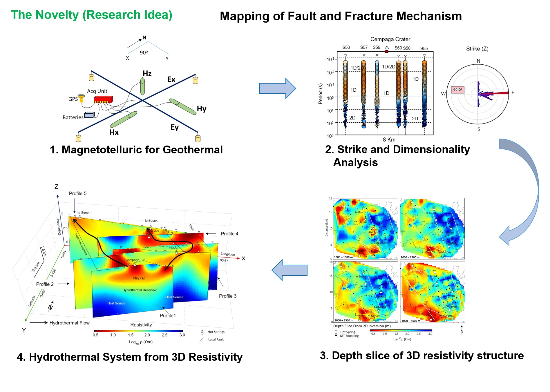
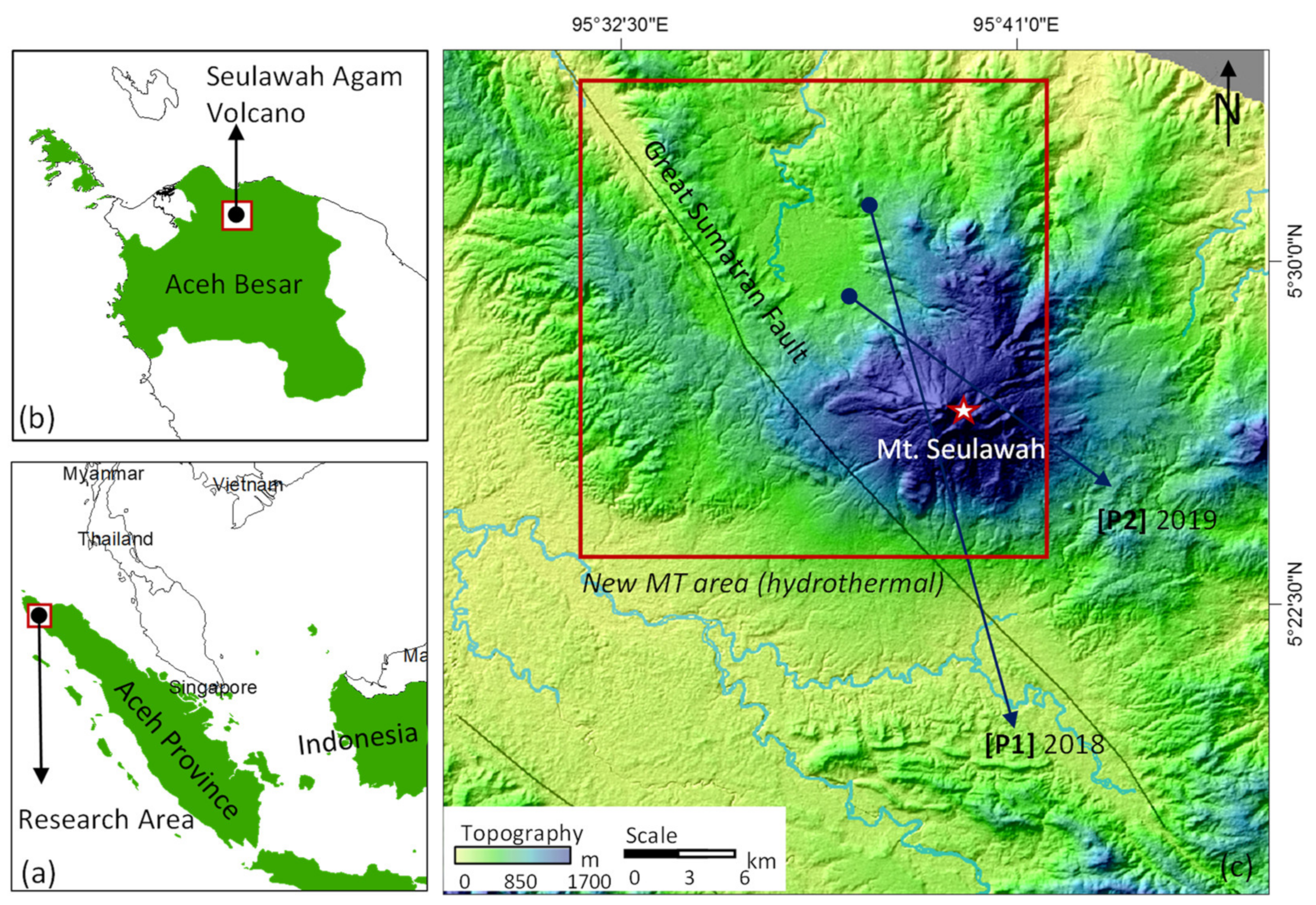
2. Seulawah Agam Geothermal Field

Mt. Seulawah Agam is a stratovolcano located in Aceh Besar District, Aceh Province, Indonesia. Currently, a plan to construct a 230-MWe geothermal power plant is underway. In general, the formation system of all volcanoes on the island of Sumatra is influenced by the Great Sumatra Fault’s (GSF) activity that stretches some 1700 km from Lampung to the Andaman Islands of India [37,38,39]. In fact, the GSF is not an intact fault block but a collection of 20 segments dispersed across the island of Sumatra [40,41], where the Seulawah Agam volcano lies close to the Seulimeum segment leading to Pulau Weh [37,41]. In addition, several local faults with an NW–SE direction were identified as the main controllers of the volcano [29,42,43] and the sites where the fluid flows above the surface, which means that the fault location is closely related to the presence of various manifestations, as shown in Figure 2.
Various geological maps [42,43] have revealed that Seulawah Agam volcano is dominated by Lam Teuba volcanic rocks consisting of andesite to dacite rocks, pumice breccias, tuff, agglomerates, and dust flows of the Pleistocene age, while during the Holocene, lahar deposits settled on the older Lam Teuba volcanic rocks. The volcano also features various other formations, including the Seulimeum, Kota Bakti, and Idi formations, which are located on the western and southern sides. Meanwhile, the volcanic activity of Seulawah Agam can be identified from various mapped surface manifestations, including one in the south that is almost adjacent to the volcanic peak, namely, the Cempaga crater, and another in the north, namely, the Heutsz crater. In addition, this section also features various hot springs, including those in the Ie Suum and Ie Jue areas. The manifestations in the Ie Jue area are characterized by the presence of warm ground, steaming ground, hot springs, fumaroles, and mud puddles, which are distributed on the northern and southern sides of the volcano. A geothermometer study demonstrated that the surface water temperature of the Ie Jue manifestation is 97.61 °C ± 0.058, while that of the Heutz crater area is 76.6 °C ± 0.08, as indicated by inductively coupled plasma (ICP) analysis [28].

3. Magnetotelluric Studies

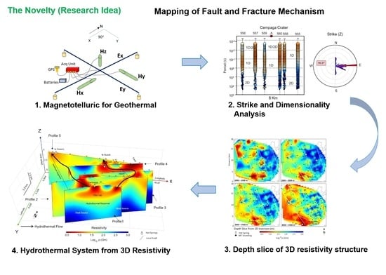
3.1. Overview of the Magnetotellurics Method

The MT method is a passive electromagnetic method that involves measuring fluctuations in the natural electric E and magnetic H fields in orthogonal directions on the earth’s surface to determine the distribution of conductivity at depths ranging from a few meters to several hundred kilometers [44,45]. The natural source of the MT field around 1 Hz is thunderstorms, while most of the signal below 1 Hz is caused by magnetospheric currents created by solar activity [46]. In the frequency domain, the measured horizontal components of the electric field E = E x E y T and the magnetic field H = H x H y T are related in terms of an impedance tensor, expressed as E = Z H , where Z is the complex number 2 × 2 of the impedance tensor, which can be mathematically expressed as follows:
Z = Z x x Z x y Z y x Z y y
The relationship between two components of the magnetic field in the horizontal direction, H x . and H y , and the vertical component H z can be written as H z = T T H , where T = T x T y is a vertical magnetic sensor known as a tipper, which is very sensitive to 3D conductivity and can provide additional information, especially regarding lateral resistivity variations [47]. This analysis can be carried out by mapping the direction of the tipper-derived induction arrow to determine the position of the concentrated conductor below the surface [48,49]. The tensor element Z i j is generally represented in the form of apparent resistivity ( ρ a   ) and phase ( φ ), which can be expressed mathematically as follows:
ρ a   = 1 μ ω Z i j ω 2 ,   and   φ = a r c t a n I m Z i j ω R e Z i j ω
To determine the model, we can formulate the point where the amplitude of the skin depth signal will decrease to 1/e of the surface current as follows [50]:
δ 503 ρ f
In addition, the Z tensor also contains information regarding the dimensions and directions. In a 1D Earth study, the impedances Z x y and Z y y (where the electric and magnetic fields are parallel) will be zero, while the off-diagonal components that combine the orthogonal electric and magnetic fields will have an equal value but opposite signs. Meanwhile, in a 2D model, the impedance components Z x x and Z y y will be equal in value but will have opposite signs, while Z x x and Z y y will have different values and opposite signs. This can be mathematically expressed as follows in Equation (4a,b):
  Z x x = Z y y = 0 Z x y = Z y y   1 D ,   and
  Z x x = Z y y Z x y Z y y   2 D
Using coordinate system rotation and distortion effect correction, Z x y can be calculated from E x and H y as well as the three field components E x , H y , H z in the electric transfer (TE) mode, while the Z y x component can be calculated from E y and H x for the transversal magnetic (TM) mode.

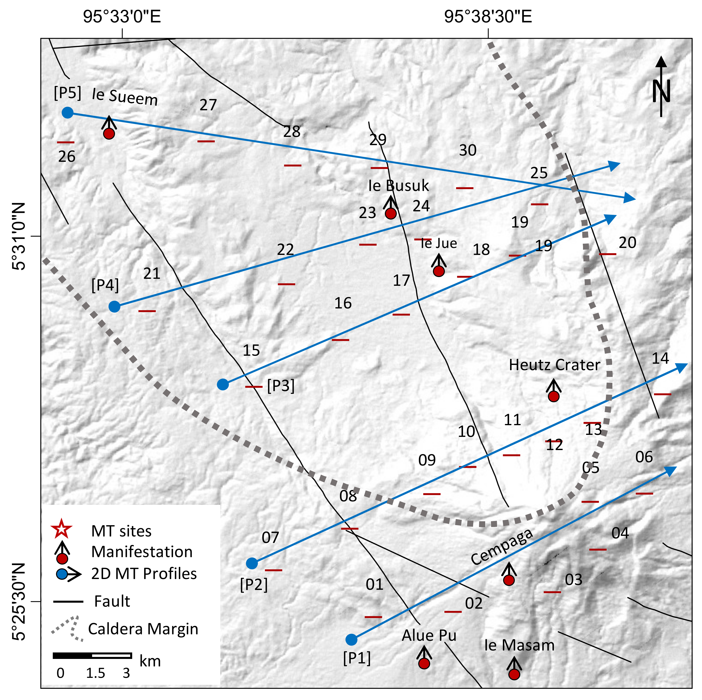
3.2. Magnetotellurics Data Acquisition

This study collected MT data from 26 sites using a Phoenix MTU-5 instrument in the broadband range (1–10 kHz). The sites’ distribution was designed to cover the entire anomaly, which is the target of Seulawah Agam volcano, starting from that of Alue Pu manifestation at the Southern part up to Ie Sueem at the Northern part of the volcano. The MT stations were placed to cover the volcanic area and cross several local faults in view of studying the entire geothermal system in Seulawah Agam. The measurements were carried out in 3D with distances between points of 500–1000 m for x and y, respectively. The entire distribution of this MT data could be divided into five profiles that intersect the faults and volcanic manifestations, as shown in Figure 3. The distances between the points have represented the covering area of the entire volcano, where several MT studies for geothermal activity used the measurement distance more than 1 km. The measurement was conducted in a regional scale, including investigation of the tectonics, where the applied distances between sites were varied between 5 to 10 km. This is similar to the volcano-tectonic mapping of the Southern Andes, Chile, that used distances between stations of ±5 km [51] and the studies on the structure of fracture in Central Tibet with the distances between stations ±10 km [52]. Meanwhile, in the small study area, the MT method was measured with the distance between sites varying from 1 to 5 km. For example, the measurement of the 3D MT at the geothermal in Southwest Iceland, in Grand Canaria Island, and Ayrobera geothermal Northeast Ethiopia with the distances between stations of ±2 km, ±4 km, and ± 1.5 km, respectively [31,32,53]. As a result, the acquired MT site distribution in this study could provide geometrical details from the hydrothermal system of the Seulawah Agam volcano. In addition, volcanoes in the subduction areas such as Indonesia are generally different from other volcanoes’ conditions from different areas, where the volcanoes are at high terrain conditions, which allows difficult on-site data collection.
The coil arrangement was created according to the standard method of MT measurement [54], where the electric field x ( E x ) is measured in the north–south direction and the y field ( E y ) in the east–west direction, with a distance between the electrodes of ±50 m. The magnetic field components H x were placed in a north-south direction, H y in an east–west direction, and H z vertically to the ground surface. In each site station, the five components of the time-varying electromagnetic field were recorded for approximately 5 h to collect the required data. In the post-processing stage, the field data was calculated using standard robust processing software (Phoenix Geophysics SSMT2000) to ensure that the data in the frequency domain was obtained in the form of apparent resistivity ( ρ a   ) and phase impedance ( φ ) for each station. Finally, the *EDI files obtained from the process can be used as input parameters for further data analysis, such as in terms of the phase tensor and the inversion process.

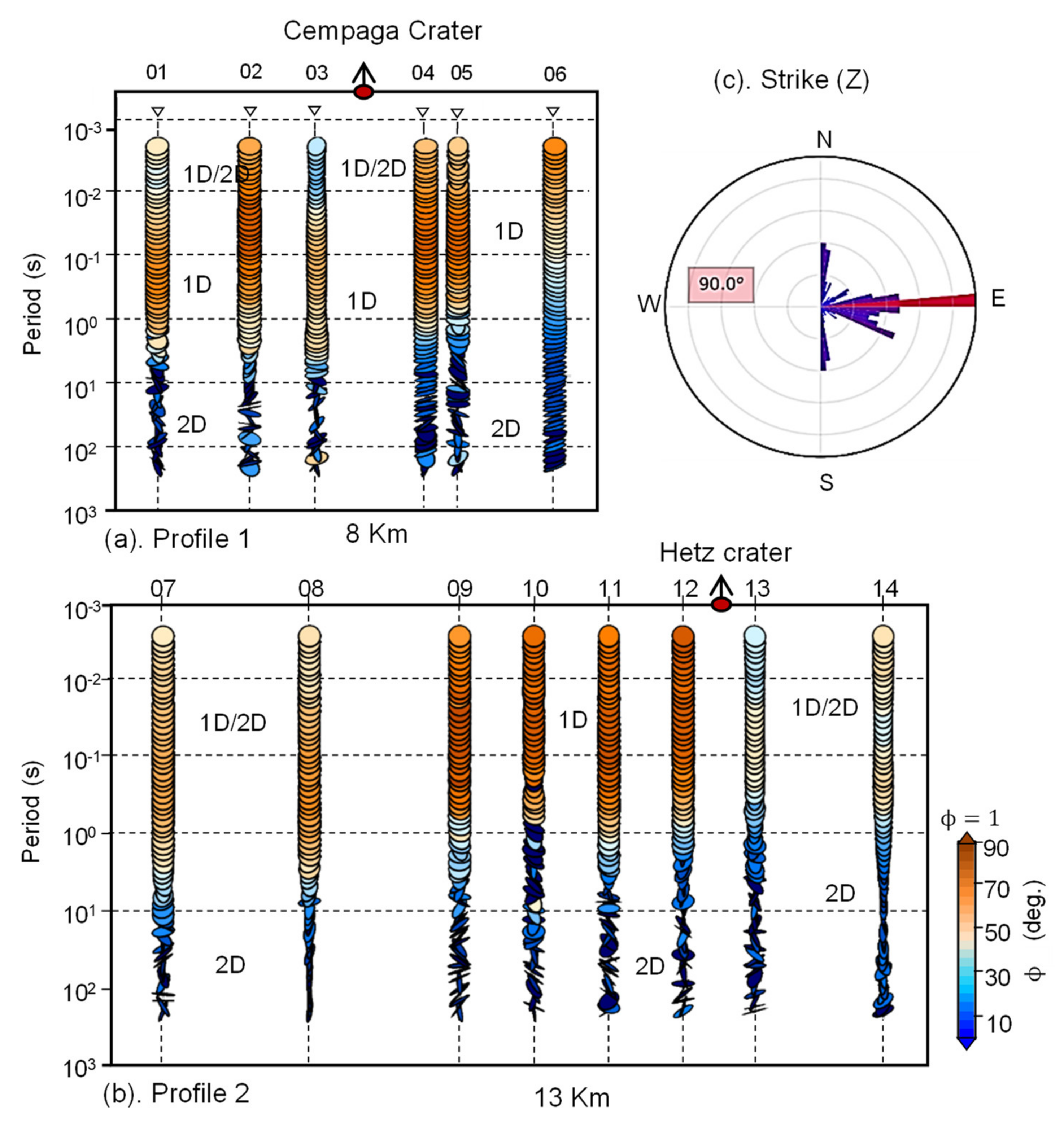
3.3. Strike and Dimensionality Analysis

In the pre-modeling stage of MT data analysis, phase tensor analysis has been widely applied to calculate the dimensions of the sub-surface anomaly structure, such that it can provide an overview of a reasonable mathematical solution [55,56]. Here, the phase data was obtained from the real and imaginary components of the impedance tensor Z = X + i Y , which is generally represented as an ellipse in terms of three values: maximum phase max (   φ m a x ) , min (   φ m i n ) , and slope angle ( β ). Mathematically, this can be described as follows:
φ = X 1 Y = R T α β   φ m a x 0 0   φ m i n   R α + β
The above equation describes the phase tensor with the parameter α as the main axis in the coordinate system. On the other hand, β is the inclination angle and has value of zero for symmetrical ellipse. Otherwise, it will describe the rotational deviation φ m a x of the symmetrical ellipse. For the 1D condition, where the ellipse is circular, the values of   φ m a x and φ m i n are equal. However, for the 2D resistivity structure (ellipse), the value of β < 3 ° is the 2D response of the impedance tensor [57]. Furthermore, the strike direction of the phase tensor can also be calculated using α β , i.e., the azimuth of the major axis [55]. We performed phase tensor analysis using Profile 1, which intersects the Cempaga crater, and Profile 2, which crosses the Heutsz crater in the SW–NE direction (Figure 3), to ensure that the appropriate inversion solution could be determined for the data, as shown in Figure 4.
In this part, we only provided tensor phase analysis toward profile 1 and 2, because they are the closest measurement points to the volcano. In addition, these two profiles cross several local fractures that become the main controller of the fluid elevation onto the surface. Additionally, both tracks also cross two craters which is the outcrop of the biggest manifestation from the volcanic activities of Seulawah Agam, with profile 1 crossing Cempaga crater and profile 2 crossing Heutz crater, so that the analysis carried out on the aforementioned profiles are capable of representing other areas in providing detailed information pertaining to the dimension of subsurface anomaly structure located at various depths. This dimensional analysis is required before the inversion [32], in which algorithms such as 1D and 2D are effective for structure mapping of the subsurface anomaly with the same dimension on the algorithm model [33]. Here, we combined the phase and ellipse data to ascertain the conductivity properties and the dimensional model of the anomaly, while we carried out the phase tensor analysis process using MTpy, a python toolbox for MT [58].
In terms of Profile 1 (Figure 4a), which intersects the area of the Cempaga crater with an area of 30,743 m2, the overall phase tensor was obtained with a value of >45° in the period of 100–10−4 s in a logarithmic scale of the six MT stations, which corresponded to the conductive anomaly generally obtained in a relatively shallow area [46]. However, at station 03, which is close to the Cempaga crater, the phase value was <45°, which is in response to the resistive anomaly below the surface. Based on the form of the phase tensor, all of the data in this period range was in the form of an ellipse, indicating that the region is dominated by 1D anomalies. Only a few places were regarded as having 2D anomalies, including the structures at the stations 03 and 01. Meanwhile, in the inner structure with a period range of 100–104 s, the tensor phase response was <45°, indicating a resistive anomaly below the surface. In addition, the phase tensor model in this period range was not in the form of an ellipse representing the dimensions in the 2D direction, which means that a 1D model solution cannot be used to predict anomalies in this period range.
In terms of Profile 2 (Figure 4b), from the measurements at eight MT stations intersecting the Heutsz crater area with an area of 23,702 m2, the phase tensor exhibited a similar trend, where, in the log 100–10−4 range, a phase tensor of >45° was obtained, indicating that conductive anomalies near the surface dominate the area. However, on the right side of the crater (site 13), a phase tensor value of 45° was obtained, showing that the anomaly at this specific location was the same as the previous station response. The obtained phase tensor model was also in the form of an ellipse, indicating that the structure of the anomaly is 1D. Therefore, the results suggest that 1D mathematical solutions can be used to predict anomalies in the area. In contrast, in the log 100–104 range, as a representative of the deep structure, a phase tensor of <45° was obtained, which indicated a response to a resistive anomaly with 2D dimensions [46,55]. The 2D regional strike in Profile 1 (Figure 4c) was estimated from the Z-invariants, the phase tensor azimuth, and the tipper strike for all periods of 90°, where the geoelectric strike analysis revealed a similar direction to the geological strike obtained from local faults found in the volcano area. The induction vectors or arrows represent the vertical magnetic field changes due to the lateral variations in electrical conductivity as a frequency function as shown in Figure 5.
Meanwhile, tipper analysis can also provide information on sub-surface structures [59], where the magnitude of the induction arrow is proportional to the intensity of the current concentration anomaly, which, in turn, is associated with the magnitude of the conductivity gradient. In contrast, the direction of the tipper arrow indicates the presence of the conductor and the distance from the resistive zone [48,60]. The tipper vector data of all measurement points were plotted in the low periods (T = 0.00515 s) to represent the near-surface area and the high periods (T = 4.65116 s) to demonstrate the conductor in the deep anomaly. In the low periods, the tipper direction indicates a large amount of noise in the near-surface area. For example, on the western side of the volcano, the tipper data points the conductor to the west, indicating the conductor’s location in the Alue PU and Ie Masam manifestations. In contrast, the northern side generally exhibited a random tipper direction focusing on the caldera margin area with manifestations such as the Heutsz crater, Ie Suum, and a number of local faults, since the conductive fluid accesses the surface via conduction and convection. On the other hand, in the high periods, all the tipper directions indicated the location of the conductor with a focus on a specific location since the tipper direction is not affected by significant noise, unlike in the area between the Heutsz and Ie Jue craters, where the conductors are likely to be in the form of heat sources. This tipper map of the tensor impedance provided information on the conductive anomaly in the near-surface area converging to the caldera margin close to the Seulawah Agam volcano.

4. Results and Discussion
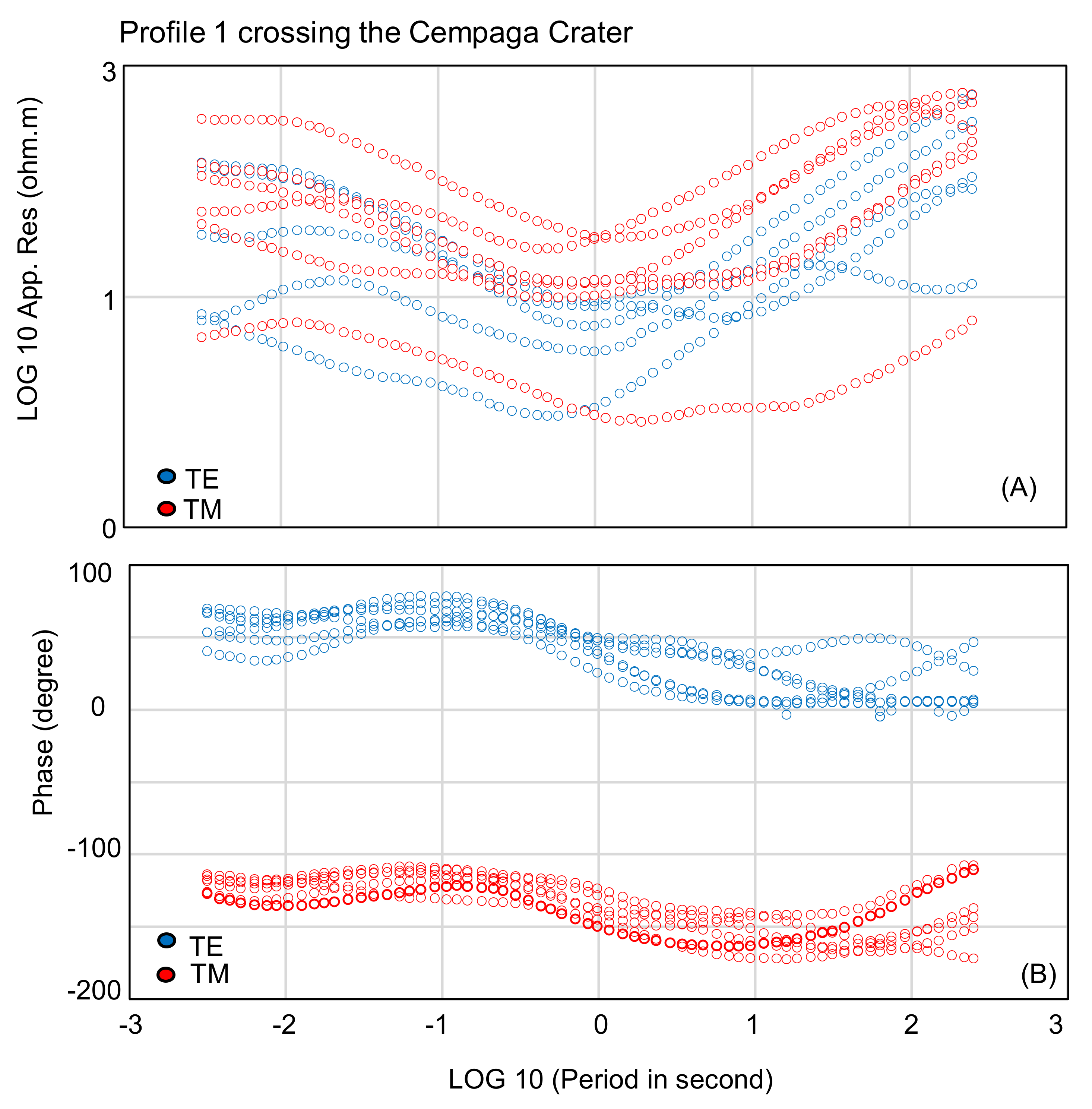
4.1. Data Response

In general, MT data in the form of apparent resistivity and phase impedance can provide an initial picture of the characteristics of the sub-surface resistivity without prior knowledge of the depth. Here, the plot of both the apparent resistivity and the phase data from Profile 1 (Figure 6), which consists of six stations cutting across the Cempaga crater in the southern part of the volcano, are presented in logarithmic scale for both electric (TE) and magnetic (TM) transfer modes, with the data first smoothed out to eliminate any noise errors caused by the measurement instruments, magnetic storms, or human error. Overall, the TE and TM data of the apparent resistivity (Figure 6A) exhibited the same characteristics but were in different phases. For example, in the log periods of 10−2.5–10−1 s, a high resistivity value was obtained, indicating the presence of a resistive anomaly at shallow depths. The same response was also obtained in the log 101–102.5 period, which was also caused by the resistive anomaly in the deep depth area.
Meanwhile, in the medium period, i.e., log 10−1 to 101 s, a low resistivity response was obtained as a response to the conductive anomaly below the surface. The difference in the response of the two modes on the MT data was due to the sensitivity to different anomalies, with the TE data being more sensitive to changes in the electric field and the TM data being more sensitive to changes in the sub-surface magnetic field. However, the overall anomaly trend indicated by the MT data was highly similar for both the TM and TE data. In addition, the resistivity curve pattern of the six stations was close to the general resistivity structure and the alteration model, which indicates geothermal potential [53]. The phase value from the MT data could also be used to determine the state of the conductor, as shown in Figure 6B. Both phase values on track 2 indicated different responses since they are in different quadrant phases, i.e., TE mode in the range of 0°–100° and TM mode in the range of 100°–200°. Generally, the phase data is plotted in the same quadrant by reducing the phase TM data by 180° [44,61]. Here, while the quadrants are different, taken as a whole, the data phase on track 2 indicated a trend response from the same anomaly. When the apparent resistivity value was high, the phase value obtained was <45°. Conversely, a phase value of >45° corresponds to the presence of conducting objects below the surface [55].

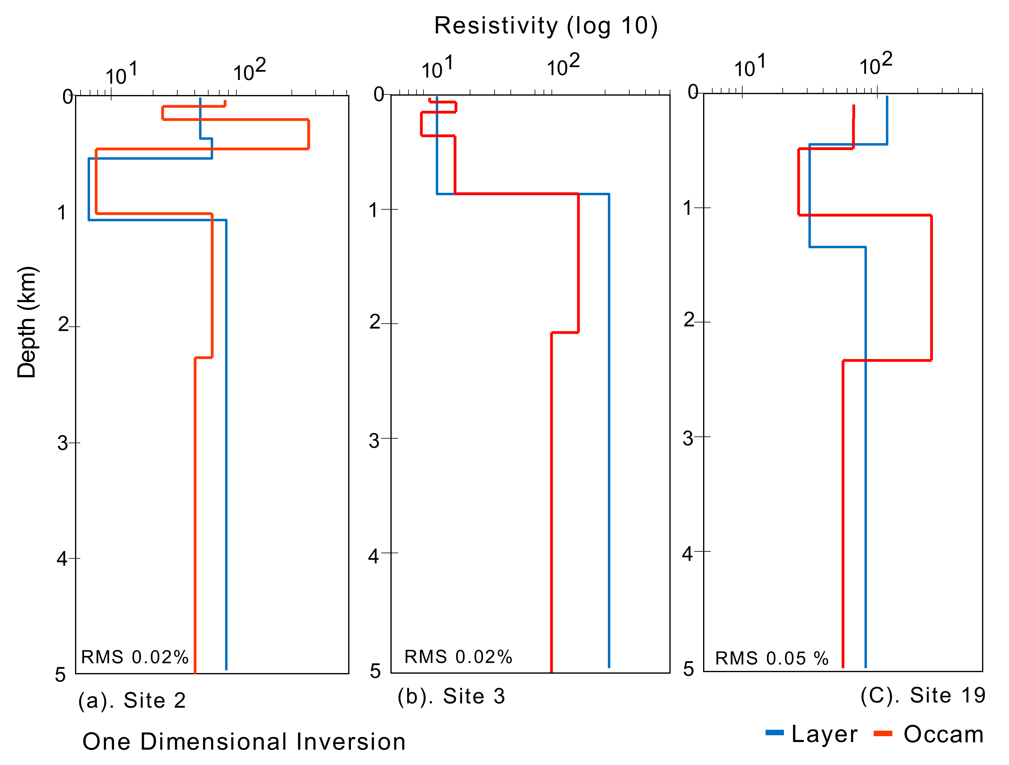
4.2. One-Dimensional Inversion

A 1D earth model was created using the Occam inversion code developed by Constable et al. [62] and Bostick [63] to produce an appropriate solution for the sub-surface 1D structure. The MT sounding curve and the 1D inversion data can provide information regarding the general structure expected from the subsequent 2D and 3D modeling. Here, we only conducted 1D inversion at three stations close to the volcanic manifestations, as shown in Figure 7. The apparent resistivity and phase data used as input parameters in the inversion process were corrected in advance, especially in terms of the high frequencies caused by a large amount of noise near the surface [64]. The 1D inversion process was carried out with the same conditions for the three MT stations. Five specific layers were used to classify the resistivity data based on a standard initial model [65], with a homogeneous half-space of 100 ohm·m. Meanwhile, the Occam model was also given five layers with a solution depth of 100–5000 m, with 10 iterations used to produce a model suitable for sub-surface conditions, as shown in Figure 7.
The data at station 02, which is close to the Cempaga crater (Figure 7a), returned 1D Occam inversion results that were similar to the resistivity layer at a depth of 5 km with an RMS of 0.02%, where a depth of 0–300 m is indicated by a moderate resistivity (60–250 ohm·m) in response to the aquifer layer near the surface. Furthermore, a depth of 300–1000 m is a conductive area (<10 ohm·m), presumed to be a layer of clay cap that prevents fluid from rising to the surface. At a 1–5 km depth, the resistivity value was moderate and equal to the aquifer layer. It was deemed to be a response to the conductive anomaly of the sub-surface reservoir and caprock. In terms of station 03, which was located near the Cempaga crater, 1D modeling results were obtained with the same model and layer response as those obtained with station 02, especially at deep depths. At the same time, they were comparatively different at shallow depths with an RMS of 0.02%. One of the factors that led to the difference in response is the distance from the measurement point to the crater location, meaning station 03 is more conductive than station 02 in shallow areas since it is closer to the crater where the fluid activity rises to the surface.
In addition, at site 19, which is located close to the Heutz crater on the northern side of the volcano, a resistivity model with an RMS of 0.5% was obtained, with the same characteristics as the Cempaga crater (site 02), especially in terms of the deep anomaly. Here, a depth of 300 m to 1 km resulted in a low resistivity value, indicating that the area is dominated by conductive rock and is deemed a clay cap layer in the form of liquid fluid that requires fractures to rise the surface. This conductive area indicates a potential geothermal zone that could be further modeled using 2D inversion. In addition, at a depth of 1–2.3 km, a high resistivity value was obtained, likely due to a hydrothermal reservoir, while at this point, a different response was obtained at a depth of 2.3–5 km, with a relatively low resistivity compared with the reservoir layer. This layer is presumed to be a heat source area where a geothermal zone is located, while it could not be identified at the other sites since 1D solutions are not sensitive to 2D anomalies. This can also be verified by phase tensor data analysis, where the layer is dominated by 2D anomalies, meaning 1D mathematical solutions are not applicable.

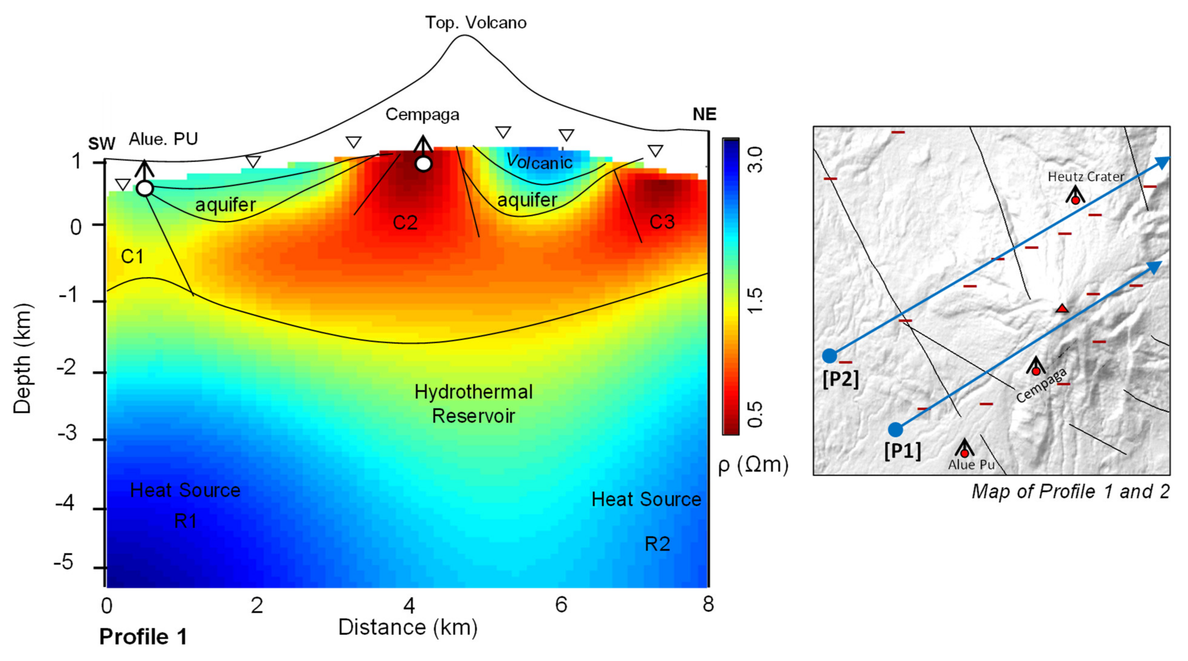
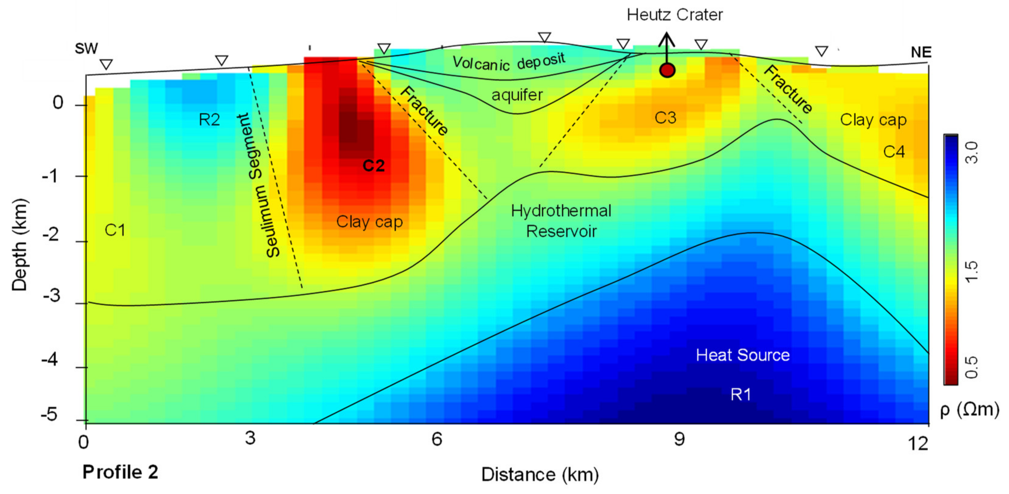
4.3. Two-Dimensional Occam Inversion

For the 2D MT inversion process for the Seulawah volcano, we used the Occam 2D inversion code developed by [66], which is based on the minimization of the following unconstrained function:
U = y m 2 + z m 2 + μ 1 W d F ) 2 X n 2
where y m 2 + z m 2 is an equation model for the roughness model for data smoothing, and μ 1 is the Lagrange value for ascertaining the minimum and maximum values. The field data will fit the calculated data, W is the diagonal weighting matrix M × M , d is the observation vector, and F m is the model response. The 2D modeling was carried out for all the MT profiles covering the local faults and volcanic manifestations. However, to explain the geothermal formation system in 2D, only two paths were necessary, i.e., Profile 1, which covers the Seulawah Agam volcano area and various manifestations, such as the Cempaga crater and Alue PU, and Profile 2, which covers the Heutsz crater on the northern side and various other local faults, as shown in Figure 8.
Based on the 2D Occam model, the resistivity value was obtained from log 0.5–3.0 ohm·m to a penetration depth of 5 km below the surface. In terms of Profile 1, there were three anomaly conductors, namely, C1, C2, and C3, whereas the anomaly resistors were identified in two locations, namely, R1 and R2. At shallow depths (<1 km), a number of conductive anomalies with a value of 10 ohm·m were obtained in response to the manifestation area, such as C1 on the western side, where there is a manifestation of Alue PU in the form of hot springs, and location C2, which includes the Cempaga crater from a distance of 2–8 km and is connected to the conductor on C3. Furthermore, the conductive anomaly from C1 to C3 was presumed to be a clay cap area that becomes a hydrothermal flow that delivers fluid to the surface. A report suggests that several volcanoes have an average temperature of the hydrothermal reservoir at 220 °C [67]. However, in [28], using geothermometer gas with the Giggenbach method, the reservoir temperature of Seulawah Agam volcano was predicted to be >225 °C. According to Houcstein [9], this suggests the volcano is suitable for power plant development. In addition, the 2D model also indicated various conductor zones connected to local faults in the measurement area, such as C1 in the S–NW direction and conductors C2 and C3 in the NW–SE direction. These faults are associated with low-resistivity anomalies that can be interpreted as channels transporting thermal energy from the heat source to shallow depths [68].
In addition, there is an accumulation of volcanic deposits on the surface area due to topographic differences with high resistivity (350 ohm·m). This anomaly can be found on the western and eastern sides, where it prevents fluid from rising to the surface, suggesting no formation of hot springs. Resistors R1 and R2, with a resistivity of >600 ohm·m, are separated by a conductor at a measurement distance of 4–6 km. These two resistors extend from the surface almost to a depth of 2 km, which is thought to be in response to the heat source area. However, one of the unique features of Seulawah Agam compared with other volcanoes is the presence of heat source areas in two locations, that is, the northern side centered around the Heutsz crater area and the southern side around the Cempaga area. Based on this information, we attempted to invert Profile 2, which only covers the Heutsz crater, as shown in Figure 9. The results indicated that four-conductor anomalies and two-resistor anomalies could be found at a depth of 1–5 km below the surface. Conductor anomaly C1 was connected to C2–C4, which is located at 0–3 km below the surface. This conductive area with a resistivity of <10 ohm·m is thought to be a clay cap layer with highly conductive characteristics that acts as a cover layer that stores heat and hot liquid in the volcanic system [69,70].
The formation process of clay cap layers in geothermal systems relates to liquids at lower temperatures or to steam condensing at shallow levels to create a highly conductive condensate layer [2]. In addition, the three conductors are separated by various other resistive anomalies in the area near the surface, ranging from 31–110 ohm·m. For example, at 3 km (R2) from the measurement profile, a volcanic deposit was deemed to exist, as was the case at 6–9 km, which is believed to be a response from volcanic deposits due to differences in the topography of the volcano. In addition, the resistive R2 anomaly is closely related to the contrast response to two local faults in the almost NW–SE direction. At this location, the fault is divided into two branches: one extending from the Ie Asam manifestation to Alue Pu, and the other the Seulimeum segment regional fault that is part of the GSF on the island of Weh Sabang [39,71].
In the manifestation area of the Heutsz crater, a low resistivity value (<10 ohm·m) was obtained in response to the conductive zone, where, on the western and eastern sides of the crater, fractures are crossing through the clay cap layer, which helps the fluid to rise to the surface, forming a hot spring with a temperature of 98 °C [28]. Liquids circulating at deeper levels tend to flow to the surface through the path with the highest permeability, such as through fracture, which provides conductive heat transfer between the heat source and the reservoir. The 2D Occam results also indicated that the reservoir layer is >2 km below the surface with a resistivity of 40–130 ohm·m, which is desirable for drilling. In addition, at 5–12 km from the measurement path, a resistive anomaly (>600 ohm·m) was identified, which was deemed to be the heat source of the Seulawah Agam geothermal zone. However, the heat source area is focused on one location only, as the second path only passes through the northern part of the volcano. This indicates that the Seulawah Agam heat source area is not centered under the top of the volcano but is located on its northern and southern sides.

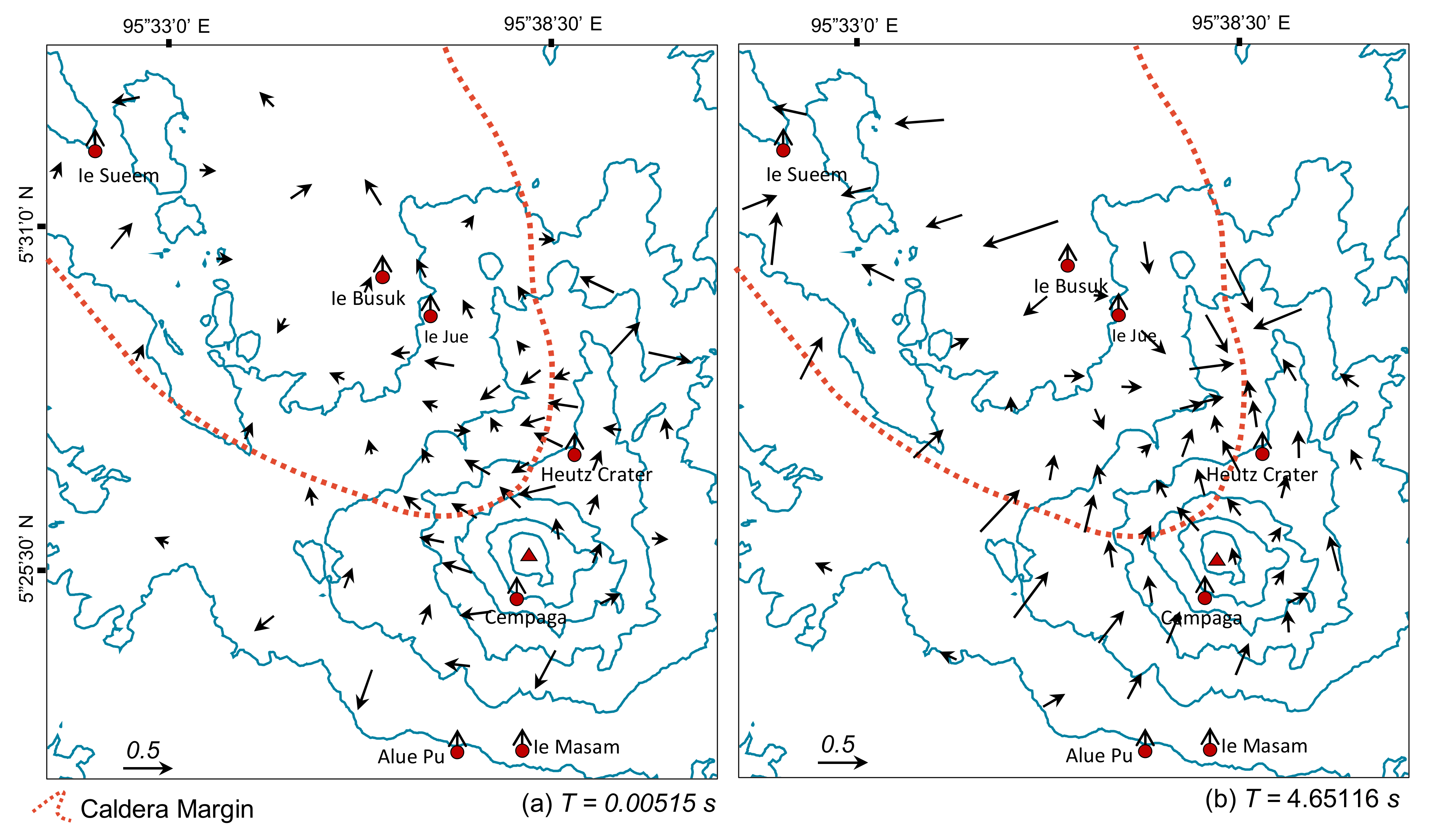
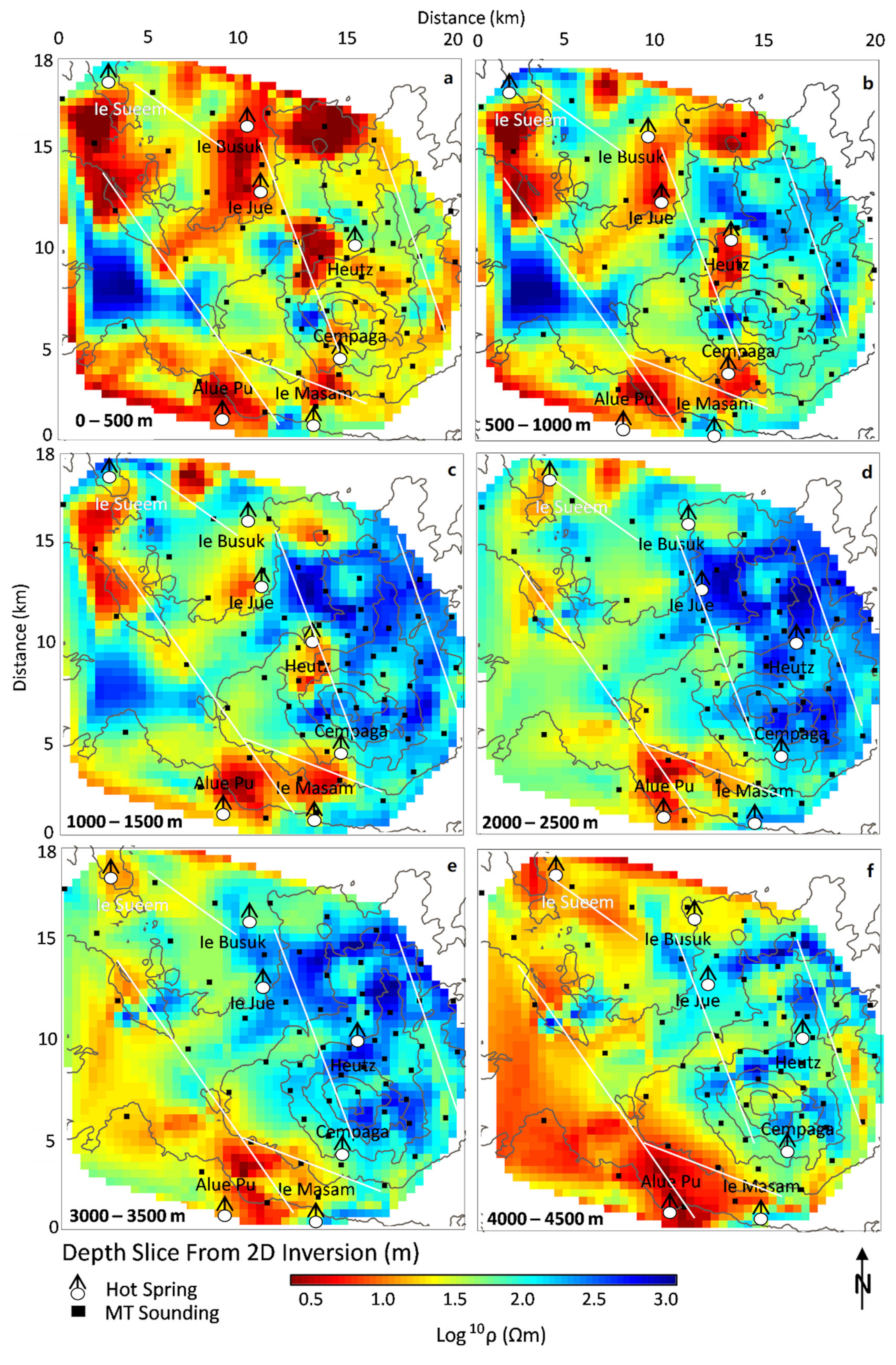
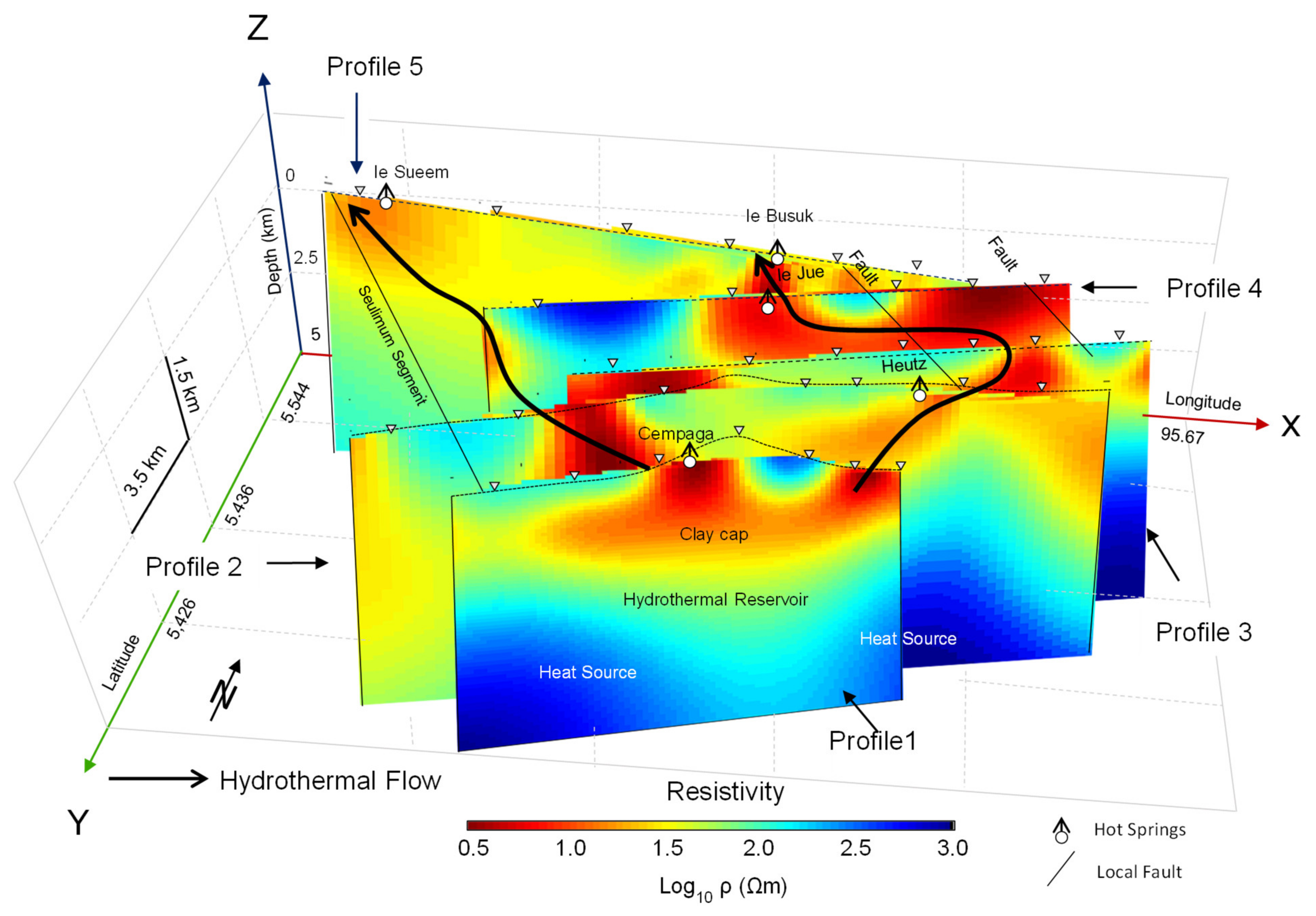
4.4. Hydrothermal System from Three-Dimensional Resistivity

The hydrothermal system of the volcano is controlled by the activity of faults and fractures where fluids pass through [72,73]. The visual representation of the 3D model was carried out by combining all of the 2D Occam inversions sliced at some depth, as shown in Figure 10. The resistivity distribution of the preferred 3D structure is now correlated to the geology of the survey area. In the near-surface area of 0–500 m in depth (Figure 10a), conductive anomalies are dominantly distributed irregularly in several locations, such as on the northwest and southeast sides, where the manifestations are generally found. Conductive anomalies can also be found around the volcano area since, in the volcanic area, there are several conductive craters, such as the Cempaga and Heutsz craters. Meanwhile, resistive anomalies are present in various locations, such as at the western and central sides, which are far removed from the manifestation locations. In addition, the contrast between conductor and resistor anomalies is closely related to the presence of various local faults in the NW–SE direction, which include the fault close to the Ie Suum manifestation, the fault from the direction of the Cempaga crater to Ie Jue, and the fault near Alue PU extending to Ie Suum, which is part of the Seulimeum Sumatra Fault segment. In terms of this area near the surface, the Occam inversion results indicated that a number of the conductors were caused by conductive pyroclastic manifestations and materials, meaning the conductive anomaly is more than the resistive one.
At a depth of 500–1000 m (Figure 10b), where the 2D cross-section revealed the depth to be a clay cap area covering the reservoir zone, the conductive anomalies are more concentrated in a number of manifestation areas, which are clearer than the previous resistivity depth. For example, in the Ie Jue and Ie Busuk manifestation areas, there is a conductive anomaly in the SW–NE direction that is presumed to be hydrothermal flow caused by local faults. A similar phenomenon can be observed in the Alue Pu, Cempaga, and Ie Masam areas, which exhibit a conductive anomaly with the same patterns as the fault direction, i.e., an almost NW–SE direction. Meanwhile, on the eastern side of the volcano, an anomaly was identified that is more resistive than the clay cap layer and the hot spring over the geothermal system. This is believed to present a response to the reservoir zone that carries fluid to the clay cap layer. At a depth of 1500–2000 m (Figure 10c), a conductive anomaly was found in various manifestations. On the northern side of the volcano, the anomaly began to separate between the manifestations and the other hot springs, while on the western side, the conductive anomaly was still connected between specific manifestations. This further demonstrates the uniqueness of Seulawah Agam, where the heat source zones lie on the northern and southern sides, as observed in the 2D Occam cross section. The same phenomenon was also evident at a depth of 2000–2500 m (Figure 10d), where the conductive anomaly was only found in the manifestation of the heat source on the southern side, namely, Alue Pu and Ie Masam, but the anomaly begins to separate, which shows the discontinuity of the fault in that area, indicating the fault’s discontinuity. In addition, at a depth of 1500–2500 m, various resistive anomalies can be found, which are widely distributed around the volcanic area. A large number of resistive anomalies beneath the highly conductive clay cap layer is generally interpreted to indicate a zone of high-temperature water circulation. Therefore, these resistive anomalies can be interpreted as forming the center of the geothermal reservoir system, which is a potential target for future development.
At large depths of 3000–3500 m (Figure 10e), there was deemed to be a heat source layer centered on the northern and southern sides of the volcano, where the presence of a number of anomalies is evidenced through the high resistivity. Meanwhile, on the central side of the volcano, there exists an anomaly with lower resistivity, which is believed to be within the hydrothermal reservoir area that limits the two heat source areas. The conductive anomaly at this depth is a response to the various local and regional faults that are the main mechanism of the Seulawah Agam volcano. A similar phenomenon can be observed at a depth of 4000–5000 m, where the identified conductors are strongly associated with faults, especially the eastern side, which is a regional fault (part of the Seulimeum segment) of the Sumatran fault [21,42]. Overall, the 3D resistivity structure data provided an understanding of the geothermal system of Seulawah Agam, where the low resistivity corresponds to the thermal conduction zone, the fault contrast, and the clay cap layers; the middle resistivity corresponds to the reservoir zone over the systems; and the high resistivity presents a response to the heat source on the northern and southern sides of the volcano.

4.5. Discussion

Magnetotelluric imaging has become a common method in investigating volcanoes worldwide [3,20,31]. The method works by utilizing the Earth’s magnetic field with a frequency of 10−4–104 Hz. In this study, we applied the MT method by 16 stations covering the volcano area to investigate the hydrothermal system of Seulawah Agam, which is an important aspect of geothermal exploration. Generally, volcanoes in Indonesia, especially Seulawah Agam, are located at high terrain conditions with an altitude of 1810 mdpl, thus there are only a few regional studies that cover the entire volcanic area. There are currently reports published, but these are limited only to certain manifestations such as Ie Suum and Ie Jue conducted by geophysics and geochemistry [28,34]. Herein, we compared the results obtained based on the 3D structure of resistivities with those obtained in previous reports. Based on the 2D structure (Figure 8 and Figure 9), along with 3D anomaly (Figure 10) of MT resistivities, the main anomalous features found in the resistivity cross-sections which indicate a geothermal system, including clay cap acquired at a depth of 1 km, a reservoir layer at 2 km, and a heat source zone at 3 to 5 km below the surface. The models we had constructed in this study are preferred for geological interpretation [42].
The GSF tectonic activity on the island of Sumatra manifests itself locally through the formation of numerous buried faults striking in the Seulawah Agam volcano in the SE–NW direction. These faults are associated with a low-resistivity anomaly that can be interpreted as a channel transporting thermal energy from a heat source to a shallow depth [35]. Therefore, a number of low-contrast anomalies with various conductors are closely related to the presence of the various local faults and fractures of Seulawah Agam. The flow zone of the volcano’s hydrothermal system is presented in Figure 11. The spatial distribution of the anomalies with high conductivity in the northern and southern areas corresponds to volcanic manifestations, where partial dissolution of the conductive material responsible for the conductive anomalies in the hot spring [74]. At deep depths, high-resistive anomalies can be found on the northern and southern sides, representing the heat source area of the Seulawah geothermal system. Based on this information, we simulated the hydrothermal flow of the volcano (as shown by the black lines in Figure 11), where there is a distribution of manifestations and direct contact with faults that are the medium for fluid transfer to the surface.
In addition, the hydrothermal model also revealed that the fault on the right does not feature any manifestations since the depth of the fault does not penetrate the clay cap layer as a fluid cover of the reservoir, thus preventing the fluid from rising to the surface. On the contrary, the other two faults penetrate the clay cap area, showing that hydrothermal displacement from the reservoir to the surface takes place and forms various manifestation areas. Geothermometer data predicted that the reservoir temperature of Seulawah Agam reaching >225 °C [28], which is in line with the thermal gradient of 50 °C/km [75]. Although the thermal gradient was close to that of regional estimation, investigating a geothermal requires magmatic depth as the heat source mobilizes the hydrothermal system. The 2D MT model of profile 1 (Figure 8) and profile 2 (Figure 9), which cross the volcano, shows resistivity anomaly with a value of >600 ohm·m. It was suspected to be a heat source zone at the 3–5 km depth, in which the anomaly is located at the west side, directing to the Alue PU manifestation, and at the east side, to the Heutz crater.
Based on the pseudo-3D resistivity, the conductive anomaly was estimated as clay cap with 1 km depth in the volcano is generally directed to tracks, the west, and the east. According to on-site observation on the west side, several manifestations were obtained were obtained from the geochemistry studies, starting from the Heutz crater at 76.6 °C, the Ie Jue crater at 97.61 °C, and the Ie Busuk crater at 47.49 °C [28]. Meanwhile, on the east side, the clay cap area flows from the Cempaga crater to Ie Suum with a temperature of 86.02 °C. The fluid obtained in the clay cap layer could flow up to the surface, forming manifestations resulting from fractures that act as access media. The fracture could be observed in the 3D resistivity structure of the MT method. This interpretation is corroborated by the Transient Electromagnetic data specifically used to map the shallow structure (< 1 km) of the volcano. Altogether, the data revealed the presence of a fault directing to the Heutz crater and Ie Jue manifestations along the clay cap conductive anomaly [21,76]. At the Ie Jue and Ie Busuk manifestations, there were also found some fractures with low resistivities, indicating the fluid movement from reservoir layer, which is in line with the magnetic data having low intensity at the fracture area, as well as high conductivity that was obtained from VLF-R method [34]. The present pseudo-3D model is a combination of 2D model inversion of several profiles, although the analytical data of the tensor phase showing that on the layer characterized by 2D and 3D anomalies. Indeed, many studies suggest that the 2D inversion response could have explained the geothermal system very well [31,32,35], especially for volcanoes located in tropical regions on high topographies. However, for better results, a full 3D inversion should be applied [31,32,35].

5. Conclusions

Seulawah Agam has been intended for a potential supply source for a geothermal power plant. In geothermal exploration, the mapping of fractures along with fluid flows is a fundamental element because it provides information about the hydrothermal system formation and the flow path connected to the reservoir wells for fluid production. In this paper, a 3D MT-based survey was conducted to study the resistivity structure associated with the hydrothermal activity and the geothermal system of the volcano. The near-surface conductive layer resulting from the Occam inversion indicated the presence of volcanic deposits that can be largely found at the top of the volcano area. Another conductive anomaly was found to be related to the presence of various manifestations on the northern side, namely, the Heutsz, Ie Jue, and Ie Busuk craters, while on the southern side, there exists a number of manifestations related to the Cempaga crater, as well as to Ie suum and Alue PU. In addition, at a depth of 1 km, a low-resistive anomaly was identified as a response to a highly conductive clay cap area that functions as a zone of high-temperature water circulation and covers the fluid rising above the surface. Meanwhile, the resistivity model revealed various fractures and faults that act as a fluid access pathway whereby surface manifestations are formed. The reservoir layer was found to be at a depth of >1.5 km, with a relatively low resistivity compared with the clay cap area. This layer is the center of the geothermal reservoir system and presents a potential drilling target for future geothermal energy development. The 3D resistivity structure also revealed that a heat source area at a depth of 3 km is present in two locations with high resistivity values, i.e., on the northern side centered on the Heutsz crater area and on the southern side centered on the Cempaga crater area, which results in the hydrothermal flow between the manifestations in the north being different from that in the south. Based on data analysis, the MT method was applied to study the geothermal system of the Seulawah Agam volcano. However, the MT data must be 3D-inverted using ModEM [76] or WSINV3DMT [45] software to produce a better model.

Author Contributions

M.Y., M.Z. and M.M. participated in the design of the study. M.Y., M.M. and M.Z. carried out the statistical analysis and helped to draft the manuscript. D.S. and M.Y. participated in the inversion data. G.S.N., N.A., R.I., D.B.D. and P.G. contributed to the geological analysis of the volcano. All authors have read and agreed to the published version of the manuscript.

Funding

This study was partly supported by Terapan Grants from the Indonesian Ministry of Research and Technology with the Number 18/UN11.2.1/PT.01.03/DRPM/2021.

Institutional Review Board Statement

Not applicable.

Informed Consent Statement

Not applicable.

Data Availability Statement

Not applicable.

Acknowledgments

We would like to thank the Energy and Mineral Resources Agency of Aceh Province for providing support regarding the geological data of Seulawah Agam. We also thank Elnusa Tbk for their contribution in MT data analysis.

Conflicts of Interest

The authors declare no conflict of interest in this paper.

References

  1. Moya, D.; Aldás, C.; Kaparaju, P. Geothermal energy: Power plant technology and direct heat applications. Renew. Sustain. Energy Rev. 2018, 94, 889–901. [Google Scholar] [CrossRef]
  2. Maithya, J.; Fujimitsu, Y. Analysis and interpretation of magnetotelluric data in characterization of geothermal resource in Eburru geothermal field, Kenya. Geothermics 2019, 81, 12–31. [Google Scholar] [CrossRef]
  3. Hacıoğlu, Ö.; Başokur, A.T.; Diner, Ç. Geothermal potential of the eastern end of the Gediz basin, western Anatolia, Turkey revealed by three-dimensional inversion of magnetotelluric data. Geothermics 2021, 91, 102040. [Google Scholar] [CrossRef]
  4. Sani, A.K.; Singh, R.M.; Amis, T.; Cavarretta, I. A review on the performance of geothermal energy pile foundation, its design process and applications. Renew. Sustain. Energy Rev. 2019, 106, 54–78. [Google Scholar] [CrossRef]
  5. Pan, S.Y.; Gao, M.; Shah, K.J.; Zheng, J.; Pei, S.L.; Chiang, P.C. Establishment of enhanced geothermal energy utilization plans: Barriers and strategies. Renew. Energy 2019, 132, 19–32. [Google Scholar] [CrossRef]
  6. Mikhailenko, A.V.; Ruban, D.A. Geo-heritage specific visibility as an important parameter in Geo-Tourism resource evaluation. Geosciences 2019, 9, 146. [Google Scholar] [CrossRef] [Green Version]
  7. Marwan; Yanis, M.; Muzakir; Nugraha, G.S. Application of QR codes as a new communication technology and interactive tourist guide in Jaboi, Sabang. In IOP Conference Series: Materials Science and Engineering; Institute of Physics Publishing: Bristol, UK, 2020; Volume 796. [Google Scholar]
  8. Seyedrahimi-Niaraq, M.; Doulati Ardejani, F.; Noorollahi, Y.; Jalili Nasrabadi, S.; Hekmatnejad, A. An unsaturated three-dimensional model of fluid flow and heat transfer in NW Sabalan geothermal reservoir. Geothermics 2021, 89, 101966. [Google Scholar] [CrossRef]
  9. Hochstein, M.P.; Sudarman, S. History of geothermal exploration in Indonesia from 1970 to 2000. Geothermics 2008, 37, 220–266. [Google Scholar] [CrossRef]
  10. Held, S.; Schill, E.; Schneider, J.; Nitschke, F.; Morata, D.; Neumann, T.; Kohl, T. Geochemical characterization of the geothermal system at Villarrica volcano, Southern Chile; Part 1: Impacts of lithology on the geothermal reservoir. Geothermics 2018, 74, 226–239. [Google Scholar] [CrossRef]
  11. Leveni, M.; Manfrida, G.; Cozzolino, R.; Mendecka, B. Energy and exergy analysis of cold and power production from the geothermal reservoir of Torre Alfina. Energy 2019, 180, 807–818. [Google Scholar] [CrossRef]
  12. Cheng, Y.; Zhang, Y.; Yu, Z.; Hu, Z. Investigation on Reservoir stimulation characteristics in hot dry rock geothermal formations of china during hydraulic fracturing. Rock Mech. Rock Eng. 2021, 54, 3817–3845. [Google Scholar] [CrossRef]
  13. Wang, G.-L.; Zhang, W.; Ma, F.; Lin, W.J.; Liang, J.Y.; Zhu, X. Overview on hydrothermal and hot dry rock researches in China. China Geol. 2018, 1, 273–285. [Google Scholar] [CrossRef]
  14. Eggertsson, G.H.; Lavallée, Y.; Kendrick, J.E.; Markússon, S.H. Improving fluid flow in geothermal reservoirs by thermal and mechanical stimulation: The case of Krafla volcano, Iceland. J. Volcanol. Geotherm. Res. 2020, 391. [Google Scholar] [CrossRef]
  15. Yanis, M.; Novari, I.; Zaini, N.; Marwan; Pembonan, A.Y.; Nizamuddin. OLI and TIRS sensor platforms for detection the geothermal prospecting in Peut Sagoe volcano, Aceh Province, Indonesia. In Proceedings of the 2020 International Conference on Electrical Engineering and Informatics (ICELTICs), Aceh, Indonesia, 27–28 October 2020; IEEE: Piscataway, NJ, USA, 2020; pp. 1–6. [Google Scholar]
  16. Mia, M.B.; Fujimitsu, Y.; Nishijima, J. Exploration of hydrothermal alteration and monitoring of thermal activity using multi-source satellite images: A case study of the recently active Kirishima volcano complex on Kyushu Island, Japan. Geothermics 2019, 79, 26–45. [Google Scholar] [CrossRef]
  17. Zaini, N.; Irwandi, I.; Abdullah, F.; Meer, F. Van Der Infrared spectroscopy characteristics of mount Sinabung volcanic materials, North Sumatra, Indonesia. In Proceedings of the 3rd International Conference on Natural and Environmental Sciences, Banda Aceh, Indonesia, 26–27 July 2019. [Google Scholar]
  18. Idroes, R.; Yusuf, M.; Alatas, M.; Subhan; Lala, A.; Muhammad; Suhendra, R.; Idroes, G.M.; Marwan. Geochemistry of sulphate spring in the Ie Jue geothermal areas at Aceh Besar district, Indonesia. In IOP Conference Series: Materials Science and Engineering; Institute of Physics Publishing: Bristol, UK, 2020. [Google Scholar]
  19. Apollaro, C.; Caracausi, A.; Paternoster, M.; Randazzo, P.; Aiuppa, A.; De Rosa, R.; Fuoco, I.; Mongelli, G.; Muto, F.; Vanni, E.; et al. Fluid geochemistry in a low-enthalpy geothermal field along a sector of southern Apennines chain (Italy). J. Geochem. Explor. 2020, 219, 106618. [Google Scholar] [CrossRef]
  20. Arzate, J.; Corbo-Camargo, F.; Carrasco-Núñez, G.; Hernández, J.; Yutsis, V. The Los Humeros (Mexico) geothermal field model deduced from new geophysical and geological data. Geothermics 2018, 71, 200–211. [Google Scholar] [CrossRef]
  21. Marwan; Yanis, M.; Idroes, R.; Ismail, N. 2D inversion and static shift of MT and TEM data for imaging the geothermal resources of Seulawah Agam Volcano, Indonesia. Int. J. GEOMATE 2019, 17. [Google Scholar] [CrossRef]
  22. Liotta, D.; Brogi, A.; Ruggieri, G.; Zucchi, M. Fossil vs. active geothermal systems: A field and laboratory method to disclose the relationships between geothermal fluid flow and geological structures at depth. Energies 2021, 14, 933. [Google Scholar] [CrossRef]
  23. Wu, C.; Hu, X.; Wang, G.; Xi, Y.; Lin, W.; Liu, S.; Yang, B.; Cai, J. Magnetotelluric imaging of the Zhangzhou Basin geothermal zone, Southeastern China. Energies 2018, 11, 2170. [Google Scholar] [CrossRef] [Green Version]
  24. Hartono, D.; Hastuti, S.H.; Halimatussadiah, A.; Saraswati, A.; Mita, A.F.; Indriani, V. Comparing the impacts of fossil and renewable energy investments in Indonesia: A simple general equilibrium analysis. Heliyon 2020, 6. [Google Scholar] [CrossRef]
  25. Nugraha, R.P.; O’Sullivan, J. A key process of natural state modeling: 3D Geological model of Jaboi Geothermal field, Nangro Aceh Darussalam, Indonesia. In Proceedings of the 7th ITB International Geothermal Workshop (IIGW2018), Bandung, Indonesia, 21–22 March 2018. [Google Scholar]
  26. Marwan; Idroes, R.; Yanis, M.; Idroes, G.M.; Syahriza, A. Low-Cost UAV based application for identify and mapping a geothermal feature in Ie Jue Manifestation, Seulawah Volcano, Indonesia. Int. J. GEOMATE 2021, 20, 135–142. [Google Scholar] [CrossRef]
  27. Zaini, N.; Yanis, M.; Marwan; Isa, M.; van der Meer, F. Assessing of land surface temperature at the Seulawah Agam volcano area using the landsat series imagery. J. Phys. Conf. Ser. 2021, 1825, 012021. [Google Scholar] [CrossRef]
  28. Idroes, R.; Yusuf, M.; Saiful, S.; Alatas, M.; Subhan, S.; Lala, A.; Muslem, M.; Suhendra, R.; Idroes, G.M.; Marwan, M.; et al. Geochemistry exploration and geothermometry application in the North Zone of Seulawah Agam, Aceh Besar District, Indonesia. Energies 2019, 12, 4442. [Google Scholar] [CrossRef] [Green Version]
  29. Ismail, N.; Yanis, M.; Idris, S.; Abdullah, F.; Hanafiah, B. Near-surface fault structures of the Seulimuem Segment based on electrical resistivity model. J. Phys. Conf. Ser. 2017, 846, 12016. [Google Scholar] [CrossRef] [Green Version]
  30. Lai, Y.M.; Chung, S.L.; Ghani, A.A.; Murtadha, S.; Lee, H.Y.; Chu, M.F. Mid-Miocene volcanic migration in the westernmost Sunda arc induced by India-Eurasia collision. Geology 2021, 49, 713–717. [Google Scholar] [CrossRef]
  31. Ledo, J.; García-Merino, M.; Larnier, H.; Slezak, K.; Piña-Varas, P.; Marcuello, A.; Queralt, P.; Pérez, N.M.; Schmincke, H.U.; Sumita, M. 3D electrical resistivity of Gran Canaria Island using magnetotelluric data. Geothermics 2021, 89. [Google Scholar] [CrossRef]
  32. Cherkose, B.A.; Saibi, H. Investigation of the Ayrobera geothermal field using 3D magnetotelluric data inversion, Afar depression, NE Ethiopia. Geothermics 2021, 94. [Google Scholar] [CrossRef]
  33. Mohan, K.; Chaudhary, P.; Kumar, G.P.; Kothyari, G.C.; Choudhary, V.; Nagar, M.; Patel, P.; Gandhi, D.; Kushwaha, D.; Rastogi, B.K. Magnetotelluric Investigations in Tuwa-Godhra Region, Gujarat (India). Pure Appl. Geophys. 2018, 175, 3569–3589. [Google Scholar] [CrossRef]
  34. Daud, Y.; Nuqramadha, W.A.; Fahmi, F.; Sesesega, R.S.; Fitrianita; Pratama, S.A.; Munandar, A. Resistivity characterization of the Arjuno-Welirang volcanic geothermal system (Indonesia) through 3-D Magnetotelluric inverse modeling. J. Asian Earth Sci. 2019, 174, 352–363. [Google Scholar] [CrossRef]
  35. Ruiz-Aguilar, D.; Tezkan, B.; Arango-Galván, C.; Romo-Jones, J.M. 3D inversion of MT data from northern Mexico for geothermal exploration using TEM data as constraints. J. Appl. Geophys. 2020, 172. [Google Scholar] [CrossRef]
  36. Marwan; Syukri, M.; Idroes, R.; Ismail, N. Deep and shallow structures of geothermal Seulawah Agam based on electromagnetic and magnetic data. Int. J. GEOMATE 2019, 16, 141–147. [Google Scholar] [CrossRef]
  37. Sieh, K.; Natawidjaja, D. Neotectonics of the Sumatran fault, Indonesia. J. Geophys. Res. Solid Earth 2000, 105, 28295–28326. [Google Scholar] [CrossRef] [Green Version]
  38. Rizal, M.; Ismail, N.; Yanis, M.; Muzakir; Surbakti, M.S. The 2D resistivity modelling on north sumatran fault structure by using magnetotelluric data. IOP Conf. Ser. Earth Environ. Sci. 2019, 364, 12036. [Google Scholar] [CrossRef]
  39. Yanis, M.; Faisal, A.; Yenny, A.; Muzakir, Z.; Abubakar, M.; Nazli, I. Continuity of great sumatran fault in the marine area revealed by 3D inversion of gravity data. J. Teknol. 2020, 83, 145–155. [Google Scholar] [CrossRef]
  40. Marwan; Asrillah; Yanis, M.; Furumoto, Y. Lithological identification of devastated area by Pidie Jaya earthquake through poisson’s ratio analysis. Int. J. GEOMATE 2019, 17, 210–216. [Google Scholar] [CrossRef]
  41. Yanis, M.; Abdullah, F.; Zaini, N.; Ismail, N. The northernmost part of the Great Sumatran Fault map and images derived from gravity anomaly. Acta Geophys. 2021, 69, 795–807. [Google Scholar] [CrossRef]
  42. Bennett, J.D.; Bridge, N.R.; Djunuddin, A.; Ghazali, S.A.; Jeffery, D.H.; Keats, W.; Rock, N.M.S.; Thompson, S.J.; Whandoyo, R. The geology of the Banda Aceh Quadrangle, Sumatra-Geological research and development centre, Bandung. Explan. Note 1981, 19. [Google Scholar]
  43. Yanis, M.; Marwan, M.; Paembonan, A.Y.; Yudhyantoro, Y.; Rusydy, I.; Idris, S.; Asrillah, A. Geophysical and geotechnical approaches in developing subsurface model for gas power plant foundation. Indian Geotech. J. 2021. [Google Scholar] [CrossRef]
  44. Siripunvaraporn, W.; Egbert, G. WSINV3DMT: Vertical magnetic field transfer function inversion and parallel implementation. Phys. Earth Planet. Inter. 2009, 173, 317–329. [Google Scholar] [CrossRef]
  45. Zhang, L.; Hao, T.; Xiao, Q.; Wang, J.; Zhou, L.; Qi, M.; Cui, X.; Cai, N. Magnetotelluric investigation of the geothermal anomaly in Hailin, Mudanjiang, northeastern China. J. Appl. Geophys. 2015, 118, 47–65. [Google Scholar] [CrossRef] [Green Version]
  46. Vozoff, K. Electromagnetic methods in applied geophysics. Geophys. Surv. 1980, 4, 9–29. [Google Scholar] [CrossRef]
  47. Simpson, F.; Bahr, K. Practical Magnetotellurics; Cambridge University Press: Cambridge, UK, 2005; Volume 9780521817, ISBN 9780511614095. [Google Scholar]
  48. Chave, A.D.; Jones, A.G. The Magnetotelluric Method: Theory and Practice; Cambridge University Press: Cambridge, UK, 2012; ISBN 9781139020138. [Google Scholar]
  49. Martí, A.; Queralt, P.; Marcuello, A.; Ledo, J.; Rodríguez-Escudero, E.; Martínez-Díaz, J.J.; Campanyà, J.; Meqbel, N. Magnetotelluric characterization of the Alhama de Murcia Fault (Eastern Betics, Spain) and study of magnetotelluric interstation impedance inversion. Earth Planets Space 2020, 72, 16. [Google Scholar] [CrossRef] [Green Version]
  50. Spies, B.R. Depth of investigation in electromagnetic sounding methods. Geophysics 1989, 54, 872–888. [Google Scholar] [CrossRef]
  51. Segovia, M.J.; Diaz, D.; Slezak, K.; Zuñiga, F. Magnetotelluric study in the Los Lagos Region (Chile) to investigate volcano-tectonic processes in the Southern Andes. Earth Planets Space 2021, 73, 5. [Google Scholar] [CrossRef]
  52. Xue, S.; Chen, Y.; Liang, H.; Li, X.; Liang, X.; Ma, X.; Lu, Z.; Bai, D.; Yan, Y. Deep electrical resistivity structure across the Gyaring Co Fault in Central Tibet revealed by magnetotelluric data and its implication. Tectonophysics 2021, 809, 228835. [Google Scholar] [CrossRef]
  53. Hersir, G.P.; Árnason, K.; Vilhjálmsson, A.M.; Saemundsson, K.; Ágústsdóttir, Þ.; Friðleifsson, G.Ó. Krýsuvík high temperature geothermal area in SW Iceland: Geological setting and 3D inversion of magnetotelluric (MT) resistivity data. J. Volcanol. Geotherm. Res. 2020, 391, 106500. [Google Scholar] [CrossRef]
  54. Zhang, L.; Unsworth, M.; Jin, S.; Wei, W.; Ye, G.; Jones, A.G.; Jing, J.; Dong, H.; Xie, C.; Le Pape, F.; et al. Structure of the Central Altyn Tagh Fault revealed by magnetotelluric data: New insights into the structure of the northern margin of the India-Asia collision. Earth Planet. Sci. Lett. 2015, 415, 67–79. [Google Scholar] [CrossRef]
  55. Caldwell, T.G.; Bibby, H.M.; Brown, C. The magnetotelluric phase tensor. Geophys. J. Int. 2004, 158, 457–469. [Google Scholar] [CrossRef] [Green Version]
  56. Chambefort, I.; Buscarlet, E.; Wallis, I.C.; Sewell, S.; Wilmarth, M. Ngatamariki Geothermal Field, New Zealand: Geology, geophysics, chemistry and conceptual model. Geothermics 2016, 59, 266–280. [Google Scholar] [CrossRef]
  57. Booker, J.R. The magnetotelluric phase tensor: A critical review. Surv. Geophys. 2014, 35, 7–40. [Google Scholar] [CrossRef]
  58. Kirkby, A.; Peacock, J.; Duan, J.; Zhang, F. Development of the MTpy software package for magnetotelluric data analysis. ASEG Ext. Abstr. 2018, 2018, 1–3. [Google Scholar] [CrossRef] [Green Version]
  59. Slezak, K.; Jozwiak, W.; Nowozynski, K.; Orynski, S.; Brasse, H. 3-D studies of MT data in the Central Polish Basin: Influence of inversion parameters, model space and transfer function selection. J. Appl. Geophys. 2019, 161, 26–36. [Google Scholar] [CrossRef]
  60. Parkinson, W.D. Directions of rapid geomagnetic fluctuations. Geophys. J. R. Astron. Soc. 1959, 2, 1–14. [Google Scholar] [CrossRef] [Green Version]
  61. Karaş, M.; Tank, S.B.; Ogawa, Y.; Oshiman, N.; Matsushima, M.; Honkura, Y. Probing the relationship between electrical conductivity and creep through upper crustal fluids along the western part of the North Anatolian Fault with three-dimensional magnetotellurics. Tectonophysics 2020, 79, 228561. [Google Scholar] [CrossRef]
  62. Constable, S.C.; Parker, R.L.; Constable, C.G. Occam’s inversion: A practical algorithm for generating smooth models from electromagnetic sounding data. Geophysics 1987, 52, 289–300. [Google Scholar] [CrossRef]
  63. Delgado-Rodríguez, O.; Campos-Enríquez, O.; Urrutia-Fucugauchi, J.; Arzate, J.A. Occam and Bostick 1-D inversion of magnetotelluric soundings in the Chicxulub Impact Crater, Yucatán, Mexico. Geofis. Int. 2001, 40, 271–283. [Google Scholar] [CrossRef]
  64. Li, G.; Liu, X.; Tang, J.; Li, J.; Ren, Z.; Chen, C. De-noising low-frequency magnetotelluric data using mathematical morphology filtering and sparse representation. J. Appl. Geophys. 2020, 172, 103919. [Google Scholar] [CrossRef]
  65. Telford, W.M.; Geldart, L.P.; Sheriff, R.E. Applied Geophysics; Cambridge University Press: Cambridge, UK, 1990; ISBN 9780521326933. [Google Scholar]
  66. Degroot-Hedlin, C.; Constable, S. Occam’s inversion to generate smooth, two-dimensional models from magnetotelluric data. Geophysics 1990, 55, 1613–1624. [Google Scholar] [CrossRef]
  67. White, A.F.; Peterson, M.L. Chemical equilibrium and mass balance relationships associated with the Long Valley hydrothermal system, California, U.S.A. J. Volcanol. Geotherm. Res. 1991, 48, 283–302. [Google Scholar] [CrossRef]
  68. Wannamaker, P.E.; Hasterok, D.P.; Doerner, W.M. Possible magmatic input to the dixie valley geothermal field, and implications for district-scale resource exploration, inferred from magnetotelluric (MT) resistivity surveying. Trans. Geotherm. Resour. Counc. 2006, 30, 471–475. [Google Scholar]
  69. Yadav, K.; Shah, M.; Sircar, A. Application of magnetotelluric (MT) study for the identification of shallow and deep aquifers in Dholera geothermal region. Groundw. Sustain. Dev. 2020, 11, 100472. [Google Scholar] [CrossRef]
  70. Gao, J.; Zhang, H.; Zhang, S.; Chen, X.; Cheng, Z.; Jia, X.; Li, S.; Fu, L.; Gao, L.; Xin, H. Three-dimensional magnetotelluric imaging of the geothermal system beneath the Gonghe Basin, Northeast Tibetan Plateau. Geothermics 2018, 76, 15–25. [Google Scholar] [CrossRef]
  71. Natawidjaja, D.H.; Triyoso, W. The Sumatran fault zone—From source to hazard. J. Earthq. Tsunami 2007, 1, 21–47. [Google Scholar] [CrossRef]
  72. Liotta, D.; Brogi, A.; Ruggieri, G.; Rimondi, V.; Zucchi, M.; Helgadóttir, H.M.; Montegrossi, G.; Friðleifsson, G.Ó. Fracture analysis, hydrothermal mineralization and fluid pathways in the Neogene Geitafell central volcano: Insights for the Krafla active geothermal system, Iceland. J. Volcanol. Geotherm. Res. 2020, 391, 106502. [Google Scholar] [CrossRef]
  73. Zucchi, M. Faults controlling geothermal fluid flow in low permeability rock volumes: An example from the exhumed geothermal system of eastern Elba Island (northern Tyrrhenian Sea, Italy). Geothermics 2020, 85, 101765. [Google Scholar] [CrossRef]
  74. Peacock, J.R.; Mangan, M.T.; McPhee, D.; Wannamaker, P.E. Three-dimensional electrical resistivity model of the hydrothermal system in Long Valley Caldera, California, from magnetotellurics. Geophys. Res. Lett. 2016, 43, 7953–7962. [Google Scholar] [CrossRef]
  75. Hurwitz, S.; Farrar, C.D.; Williams, C.F. The thermal regime in the resurgent dome of Long Valley Caldera, California: Inferences from precision temperature logs in deep wells. J. Volcanol. Geotherm. Res. 2010, 198, 233–240. [Google Scholar] [CrossRef]
  76. Lewis, A.; Hilley, G.E.; Lewicki, J.L. Integrated thermal infrared imaging and structure-from-motion photogrammetry to map apparent temperature and radiant hydrothermal heat flux at Mammoth Mountain, CA, USA. J. Volcanol. Geotherm. Res. 2015, 303, 16–24. [Google Scholar] [CrossRef]
Figure 1. (a) Map of the measurement location showing the Seulawah Agam volcano in northernmost of Aceh Province, (b) the volcano is located in Aceh Besar, 85 km from Banda Aceh, while (c) is the topography of the volcano that located in the area close to the Great Sumatran Fault (GSF). P1 is present the Profile 1 of 2D MT measurement evaluated in 2018 [36], while P2 is Profile 2 that was published in 2019 [21].
Energies 14 06091 g001
Figure 2. (A) Geological map of the Seulawah Agam volcano [42]; (B) photo documentation of the Heutsz crater emitting sulfur oxide gas in an area close to the top of volcanic with an altitude of 700 m asl; and (C) documentation of a mud pool with a temperature of 89.05 °C [28]. At the Heutz crater area, some neo-formational minerals were also found, such as sulfur, sulfatara, mudpole, and fumarole, indicating the volcanic activities of Seulawah Agam Mountain.
Energies 14 06091 g002
Figure 3. Topographic map showing the distribution of MT sites intersecting several local faults spread across the Seulawah Agam volcano. These MT stations cover the distribution of manifestations from Ie Masam to Ie Suum, which form the caldera margin area.
Energies 14 06091 g003
Figure 4. Pseudo-section showing the phase ellipses and minimum phase of the MT profile. The blue colours represent phase minimums below 45°, while the red colours represent phase minimums above 45°. (a) Profile 1 intersecting the Cempaga crater, (b) Profile 2 crossing the Heutsz crater, and (c) preferential strikes estimated from the Z-invariants, the phase tensor azimuth, and the tipper strike plotted at NW–SE (90° azimuth) from the phase tensor.
Energies 14 06091 g004
Figure 5. Tipper vector data showing the direction of the conductor at (a) a shallow depth (T = 0.00515 s) and (b) a large depth (T = 4.65116 s) below the surface. The blue lines represent the elevation contour with an interval of 300 m, while the red icons represent the manifestation area.
Energies 14 06091 g005
Figure 6. Examples of the observed MT data in Profile 1 with six stations crossing the Cempaga crater of the volcano: (A) data on apparent resistivities (ohm·m) and (B) impedance phases (degree) as a function of log10 periods (s). The red represents the TM mode, while the blue represents the TE mode.
Energies 14 06091 g006
Figure 7. The inversion results were obtained via Occam calculations at various measurement stations: (a) site 02 and (b) site 03, which are located close to the Cempaga crater and the top of the volcano, respectively; (c) site 19, which is close to the Heutz crater. The blue line is the initial layer of the model, while the red line is the result of Occam inversion with 10 iterations.
Energies 14 06091 g007
Figure 8. Resistivity model was obtained from the 2D inversion of Profile 1, which crosses the Cempaga crater. To the right is a map showing the crossing area from both profiles. Conductive areas were identified at several locations that intersect with manifestations and faults.
Energies 14 06091 g008
Figure 9. Two-dimensional resistivity model obtained from the Occam inversion on Profile 2 covers several local and regional faults and the Heutsz crater area. The conductors in this area are closely related to geothermal energy in the Seulawah Agam volcano.
Energies 14 06091 g009
Figure 10. Depth slice of 3D resistivity combined from the results of the 2D inversion model on several paths. This 3D model was sliced at several depths, (a) 0–500 m, (b) 1000 m, (c) 1500 m, (d) 2000 m, (e) 3500 m, and (f) 4500 m, in view of mapping the fractures and hydrothermal flows in the volcano. The white line represents a local fault derived from Bennett et al. [42].
Energies 14 06091 g010
Figure 11. Hydrothermal flow from pseudo-3D resistivity in the Seulawah Agam volcano. The thick black lines represent the estimated hydrothermal flow.
Energies 14 06091 g011
Publisher’s Note: MDPI stays neutral with regard to jurisdictional claims in published maps and institutional affiliations.

