Article

Lessons Learned from a Pilot Study of the Relationship Between Rainfall and Levels of 1,4-Dioxane and Metals in Water Bodies Adjacent to Superfund Sites on Long Island, New York, USA


1
Program in Public Health, Stony Brook University, Stony Brook, NY 11794, USA
2
Program in Biology, Stony Brook University, Stony Brook, NY 11794, USA
3
Stony Brook University Underrepresented Pre-Med Scholars Program (SUPREMES), Stony Brook University, Stony Brook, NY 11794, USA
4
Program in Biology, SUNY Old Westbury College, Westbury, NY 11568, USA
5
Program in Applied Mathematics, Stony Brook University, Stony Brook, NY 11794, USA
6
School of Medicine, Drexel University College of Medicine, Philadelphia, PA 19104, USA
7
West Islip High School, West Islip, NY 11795, USA
8
School of Marine and Atmospheric Sciences, Stony Brook University, Stony Brook, NY 11794, USA
9
New York State Center for Clean Water Technology, Stony Brook University, Stony Brook, NY 11794, USA
10
Department of Civil and Environmental Engineering, New Jersey Institute of Technology, Newark, NJ 07102, USA
11
Department of Chemistry, Carnegie Mellon University, Pittsburgh, PA 15213, USA
12
Department of Family, Population, and Preventive Medicine, Renaissance School of Medicine at Stony Brook University, Stony Brook, NY 11794, USA
*
Author to whom correspondence should be addressed.
Int. J. Environ. Res. Public Health 2026, 23(9), 1173; https://doi.org/10.3390/ijerph23091173
Submission received: 3 August 2026 / Revised: 29 August 2026 / Accepted: 1 September 2026 / Published: 7 September 2026

Highlights

Public health relevance—How does this work relate to a public health issue?
  • Climate-driven changes in rainfall intensity and frequency may influence contaminant mobility at Superfund sites, affecting water quality and potential human exposure.
Public health significance—Why is this work of significance to public health?
  • There is limited public health research on how heavy rainfall events impact concentrations of contaminants in water near Superfund sites.
Public health implications—What are the key implications or messages for practitioners, policy makers and/or researchers in public health?
  • Monitoring programs should account for temporal variability and seasonal rainfall when interpreting contaminant measurements near Superfund sites.
  • Further research is needed to understand how climate-driven changes in precipitation influence contaminant transport and exposure risk.

Abstract

Rainfall and groundwater fluctuations may influence the migration or dilution of contaminants from US Superfund sites. This pilot study was designed to provide empirical data on relationships between rainfall and contaminant concentrations in water near Superfund sites. Four heterogeneous Superfund sites on Long Island, New York, were selected to represent a range of contaminant profiles and hydrogeologic conditions. Baseline samples were collected in December 2022, with subsequent samples obtained following major storms through September 2023. Samples were collected on 11–24 different days across the sites and measured for 18 metals and 1,4-dioxane. Overall, we observed few consistent associations between rainfall and contaminant concentrations across sites. Two trends, however, were noted: (1) at Gowanus Canal, a surface water site, there was a negative association between rainfall and contaminant concentrations using same-day or prior-day rainfall; and (2) in effluent from a treatment well near Lawrence Aviation, negative associations were observed between prior month’s rainfall and contaminant concentrations. Rainfall appeared to dilute contaminant concentrations using different hydrogeological processes at two of the four Superfund sites in this pilot study with a small sample size and study site heterogeneity. Given the increased frequency and intensity of extreme rainfall events, it is important to continue probing links between rainfall and contaminants near Superfund sites with intensive monitoring campaigns.

1. Introduction

Climate change poses an existential threat to environmental and human health, as it drives an increase in extreme weather events including increased flooding [1]. Amolegbe et al. describes how rising temperatures, intensified precipitation, and sea-level rise (SLR) heighten flooding risks which may be of particular concern in areas with hazardous waste sites [1]. Furthermore, heavy rainfall and flooding may impact U.S. Superfund sites, which are contaminated locations designated under the Comprehensive Environmental Response, Compensation, and Liability Act (CERCLA) for long-term cleanup due to hazardous waste [2]. These locations contain hazardous contaminants that might be mobilized by heavy precipitation [3]. Approximately 60% of Superfund sites are located in regions vulnerable to climate disasters, and over 1000 are at risk from rising sea levels [4]. Flooding events may therefore enhance the transport of contaminants from these sites into surrounding ecosystems [5,6].
Hydrogeochemical theory and monitoring data suggest that dynamic rainfall variability, groundwater fluctuations, and evapotranspiration influence the migration of contaminants, including metals, organic chemicals, and radioactive substances [7,8,9]. Contaminants in soil can become mobilized by water level fluctuations which alter redox states, and by saltwater intrusion driven by SLR. For example, seasonal spring flooding appears to mobilize dissolved Pb in inundated areas [9], and groundwater table fluctuations due to rainfall have been linked to the mobility of chromium (Cr) [10]. Models suggest that 326 Superfund sites across 18.1 million hectares are vulnerable to changes in groundwater depth or transport direction due to SLR [11]. Anticipated alterations in soil biogeochemical and hydrological conditions could also affect the retention of contaminants such as arsenic (As) and other trace metals or metalloids [12,13].
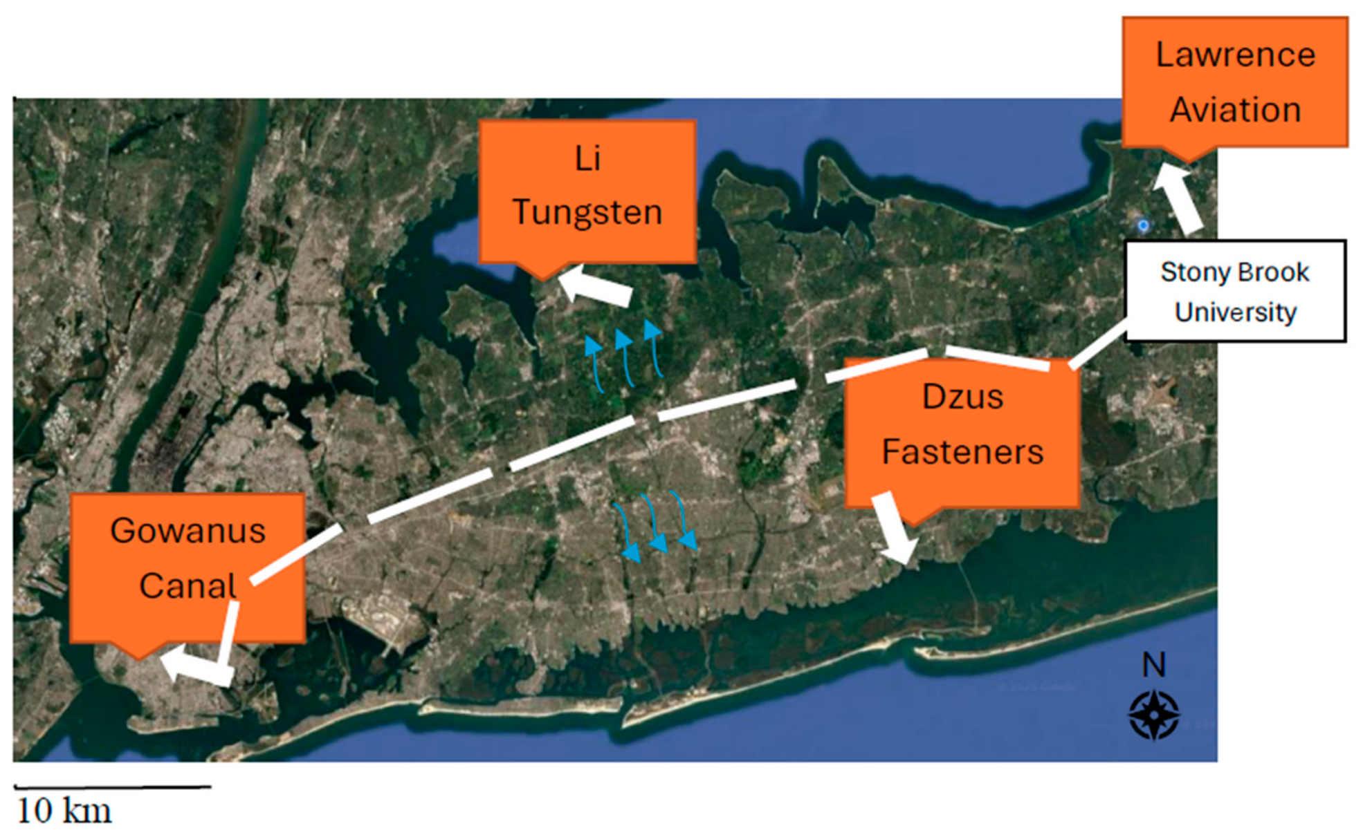
Long Island, New York, is underlain by a sequence of several sole-source aquifers composed primarily of permeable sand and gravel. Long Island is generally formed by two lines of hills of glacial moraines running along its axis. The groundwater divide generally runs along the long axis of the island from east to west (Figure 1). Groundwater flows approximately north or south from the divide curving to intersect the shoreline perpendicularly. Local groundwater seepage from the shallowest, the Upper Glacial Aquifer, is the primary source of freshwater in streams, lakes, and wetlands, and maintains the saline balance of bays and harbors, augmented by any runoff during extreme precipitation events [14].
The water table elevation can change by more than four feet over the course of a month [14]. Any changes in the hydraulic gradient would result in a temporary change in direction and rate of volume flow and in hydraulic dispersion. Because groundwater flow rates are typically less than a fraction of a meter per day, contaminants would not be displaced far before the groundwater system relaxed to its usual position and the dispersive impacts, rather than advective displacement, would dominate [14]. At coastal sites, marine flooding due to storm surge contributed to the mobility of contaminants from some sites. At a New York State Superfund site (DZUS), contaminants moved into a nearby creek after the water table rose during the storm surge from Superstorm Sandy in 2012 [15]. Storm surges greater than 5 feet have a return every few years.
Outside of the two boroughs of New York City, that occupy the western part of Long Island (Brooklyn and Queens), all the potable water is drawn via public-supply wells tapping Long Island’s aquifer system. Long Island provides an opportunity to investigate the effects of storms on contaminant transport from hazardous sites due to its 22 federal Superfund sites, dense population, and a history of heavy precipitation and hurricanes. However, it remains unclear whether rainfall primarily leads to contaminant dilution or mobilization, or whether effects might differ by site based on local geochemistry. To address this gap, samples were collected from water near four Superfund sites over the course of nine months to conduct an exploratory pilot study to evaluate whether rainfall intensity and timing were associated with changes in contaminant concentrations in surface and groundwater.

2. Materials and Methods

2.1. Site Selection

Four sites in Long Island, NY (Figure 1; Table 1), were chosen to represent a range of contaminant types, industrial histories, and hydrogeologic conditions (Figure 1). These are (1) Lawrence Aviation Industries [16] in Port Jefferson, (2) Li Tungsten [17] in Glen Cove, (3) Dzus Fasteners Co. Inc. [18] in West Islip, and (4) Gowanus Canal [19] in Brooklyn. We selected Lawrence Aviation because of its ease of access from (i.e., close proximity to) Stony Brook University and a plume running from the site toward the Long Island Sound. Li Tungsten was selected because shallow groundwater from the site discharges directly to Glen Cove Creek, which flows into the Long Island Sound, and because residual heavy metals and radionuclides remain in the shallow aquifer, making this site well-suited for testing whether rainfall influences contaminant transport to a coastal receiving water body. Dzus Fasteners was selected because it was impacted during Superstorm Sandy, inundated with seawater, and contaminants moved toward the Atlantic Ocean as water receded. Gowanus Canal was selected because it was also impacted by Superstorm Sandy with contaminants moving from the canal into surrounding neighborhoods.
Lawrence Aviation. This is a former titanium sheet manufacturing site for the aeronautics industry [16]. The site lies in a residential area at an elevation of 271 feet atop a sequence of sole-source groundwater aquifers, composed primarily of sand and gravel, over 700 feet thick. Fresh surface waters near the site are groundwater fed and include small ponds and streams. The downgradient-contaminated groundwater plume extends into a residential area where septic systems are common and contain volatile organic compounds (VOC). In situ chemical oxidation had been applied at the site and at Old Mill Creek (Supplemental Figure S1) to prevent the discharge of contaminated water. Contaminated groundwater plumes reach Long Island Sound over a distance of about 1.3 miles. Groundwater discharges naturally to Long Island Sound from streams, coastal springs, and submarine seepage. Homes with private wells impacted by groundwater contamination have been connected to public water supplies.
Li Tungsten. This is a former processing facility for ore and scrap tungsten [17]. Contaminated soil with radionuclides and heavy metals were removed; however, residual radionuclides and metals remain on-site. The Li Tungsten Superfund Site sits atop a sole-source groundwater aquifer of permeable deposits. Shallow groundwater discharges to nearby streams and ultimately to the Long Island Sound and its harbors. The area is primarily industrialized, but with some residences nearby. The shallow aquifer is not currently a source of potable water, and there are no drinking water wells in the vicinity of the site. People living near the site are supplied with potable, public water.
Dzus Fasteners Co. Inc. This site was active from 1937 to 2015 as a manufacturing site for metal and spring operations [18]. Metal plating and anodizing wastes such as oils, heavy metals, and salts were deposited into leaching pools on-site that evidently leached into the underlying soil and groundwater. Both surface water runoff and groundwater which flows 3 m below the site, feed Willetts Creek which drains into a man-made lake.
Gowanus Canal. The Gowanus Canal is a tidally influenced, dead-end channel that opens to New York Harbor [19]. Fresh surface water enters the canal from combined sewer outflows and stormwater discharges. The canal sits in fill material from its construction and subsequent industrialization. The fill overlies buried layers of sand and marsh deposits. Groundwater in the fill and alluvial/marsh deposits discharges to the canal. The sole-source aquifer below the alluvial/marsh deposits is composed primarily of sand and gravel but is not used as a potable water supply in this part of Brooklyn. Public water is supplied via underground aqueducts from upstate. This 100-foot-wide, 1.8-mile-long canal empties into New York Harbor and was historically used for transportation and manufacturing. The Gowanus Canal is one of the nation’s most contaminated water bodies with more than a dozen contaminants, including polycyclic aromatic hydrocarbons (PAHs), polychlorinated biphenyls (PCBs), and heavy metals (Hg, Pb, Cu).

2.2. Sampling and Laboratory Procedures

Baseline samples were collected in December 2022 at each site. Subsequent samples were obtained following major storms through September 2023. A storm-prediction framework was employed to identify potential heavy rainfall events for deploying sampling. In particular, from December 2022 to September 2023, every other day the team analyzed operational forecasts from the local National Weather Service office [20] at 3-day to 5-day lead times. If forecasted daily rainfall accumulations were above 0.7 inches (~18 mm), the sampling team was alerted of a potential storm event and recommended to sample before, during and after the event. This precipitation threshold was selected as it represents the upper 5% of daily precipitation on average (i.e., approximately the top 18 days of rainfall each year) for the period of 2001–2020. This threshold is based on the analysis of three different observational precipitation datasets for Long Island, NY, as documented in [21]. When storm events were forecasted to result in a daily accumulated rainfall of over 2 inches (~50 mm), representing the average annual maximum daily precipitation event for the region, the sampling team was further encouraged to sample. For example, see Supplemental Figure S5.
Based on team availability and storm event timing, samples were collected on 24 different days near Lawrence Aviation, 15 days near Li Tungsten, 11 days near Dzus Fasteners, and 16 days from Gowanus Canal. Field staff consisted of volunteers and were not available to sample on all days. Lawrence Aviation was closest to Stony Brook and had the highest number of samples; Dzus was sampled by students in a high school environmental science class and had the lowest number of samples. The other sites were sampled by students volunteering for the project who happened to live near the sites. For 1,4-dioxane, 250 mL polypropylene bottles were used to collect water, and samples were collected in duplicate; the mean of the two samples is reported. For metals analysis, water was collected in a 15 mL clear polypropylene bottle indicated for trace metals analysis. Field blanks were collected at 10% of sampling events. All samples were chilled during transport and stored in the lab refrigerator at 4 °C until extraction, within 28 days as recommended by EPA Method 522 [22].

2.3. Metals Measurements

Elemental analysis was performed using an Agilent 7900 Inductively Coupled Plasma—Mass Spectrometry system (ICP-MS) equipped with a collision cell operated in helium mode. Data acquisition, calibration, quantitative analysis, semiquantitative analysis, and data processing were performed using the Agilent MassHunter software. Samples were analyzed for 18 heavy metals: beryllium (Be), manganese (Mn), cobalt (Co), zinc (Zn), arsenic (As), selenium (Se), strontium (Sr), molybdenum (Mo), cadmium (Cd), tin (Sn), antimony (Sb), cesium (Cs), barium (Ba), platinum (Pt), mercury (Hg), thallium (Tl), lead (Pb) and uranium (U). Samples were analyzed without filtration unless visible particulate matter was present. Two samples containing visible particles were filtered through 0.2 µm polyethersulfone (PES) membrane filters before analysis.
Be, Mn, Co, Zn, As, Se, Cd, Sb, Ba, Tl, and Pb were determined quantitatively using multi-point external calibration. For Be, Mn, Co, Zn, As, Cd, Sb, Ba, Tl, and Pb, the calibration sequence comprised eight active concentration levels: 1, 4, 8, 9.99, 19.96, 39.84, 99.01, and 196.08 µg/L. Se was present at approximately fivefold higher concentrations in the multielement calibration standards, corresponding to a calibration range of approximately 5–980 µg/L. Calibration blanks were analyzed at the beginning of each quantitative analytical sequence, and additional blanks were included throughout the sample batches to monitor background contamination and potential carryover. Internal standards (Sc-45, Ge-72, In-115, Bi-209) were added to all standards, blanks, and samples to correct for instrumental drift and matrix effects. Method blanks were analyzed periodically throughout the analytical sequence to ensure data quality. Sample concentrations were determined from the calibration curves and reported after applying the appropriate dilution factors.
Seven additional elements—Sr, Mo, Sn, Cs, Pt, Hg, and U—were analyzed semi-quantitatively because analyte-specific multi-point calibration standards were not available. A SemiQuant standard (SQStd; nominally 9.99 µg/L for the reference elements) was analyzed to correct the instrumental response and establish the SemiQuant response relationship across the mass range. Element concentrations were estimated using semi-quantitative calibration algorithm and should be considered approximate values intended for screening purposes only (within ±20–30%). Instrumental repeatability was evaluated from replicate ICP-MS measurements and featured a mean relative standard deviation (RSD) of 14.3 ± 9.28%. Analyte-specific method detection limits (MDLs) are reported in Table 2.

2.4. 1,4-Dioxane Measurements

Samples were stored at 4 °C until extraction by solid-phase extraction (SPE). Briefly, 200 mL of each water sample was spiked with 1,4-dioxane-d8 as a surrogate standard and extracted following U.S. EPA Method 522. SPE cartridges (Restek, Cat. No. 26032) were conditioned sequentially with dichloromethane (DCM), methanol, and ultrapure water. Samples were then loaded onto the cartridges under vacuum at a flow rate of approximately one drop per second. Analytes were eluted using DCM containing tetrahydrofuran-d8 as an internal standard. 1,4-dioxane was analyzed using an Agilent 7890 gas chromatograph coupled to a 5975-mass spectrometer (GC/MS). Separation was achieved using a fused-silica capillary column (Agilent J&W CP-Select 624 CB (Santa Clara, CA, USA), 30 m × 0.25 mm i.d., 1.4 µm film thickness). The mass spectrometer was operated in selective ion monitoring (SIM) mode. A 1 µL aliquot of the extract was injected for analysis. The GC inlet temperature was maintained at 200 °C, and helium was used as the carrier gas at a constant flow rate of 1 mL min−1. The GC oven temperature program ramped from 30 °C to 200 °C. The MS transfer line, ion source, and quadrupole temperatures were each set to 150 °C. Data acquisition and analysis were performed using the Agilent ChemStation software version C.01.10. The average surrogate recovery for the analyzed samples was 68.8 ± 8.8%.

2.5. Rainfall Measures

To quantify the actual rainfall amounts on the day of sampling, prior day, past week, and past month, data were obtained from Community Collaborative Rain, Hail and Snow Network (CoCoRaHS) which is routinely used by the National Weather Service including the local Forecast Office. CoCoRaHS is a network of volunteers who document precipitation amount and type using a standardized gauge across all fifty U.S. states with support from the National Oceanic and Atmospheric Administration and the National Science Foundation [21]. For our analysis here, we locate the CoCoRaHS nearest to the sampling site: Port Jefferson, NY (station: NY-SF-100), Glen Cove Creek, Glen Cove, NY (station: NY-NS-42), Willetts Creek, West Islip, NY (station: NY-SF-73), and Gowanus Canal, Brooklyn, NY (station: NY-KN-25). Note that there are differences between forecasted precipitation amounts days in advance and the measured amount of actual rainfall. For more details, see the Supplementary Materials.

2.6. Statistical Analysis

Simple linear regressions were conducted (SAS v9.4) to examine the associations between rainfall variables (daily, prior day, past week, and past month) and contaminant concentrations at each site.

3. Results

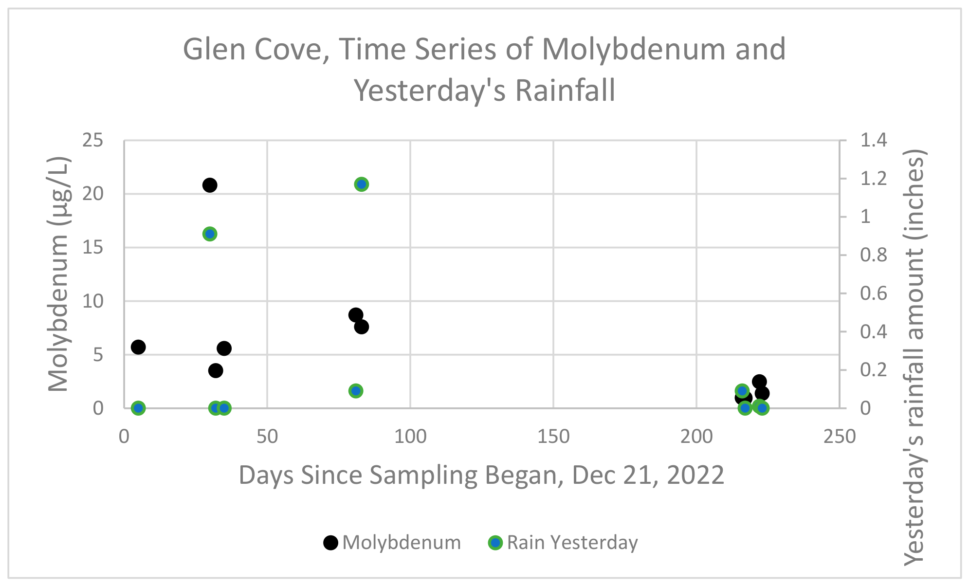
The minimum, maximum, and mean levels of the metals and 1,4-dioxane measurements from all samples are reported in Table 2. As is typical for environmental samples, Sr, Ba, and Zn had consistently higher levels than the other metals. Cs was elevated to above 2000 µg/L in two samples from Lawrence Aviation and Willetts’s Creek, but most samples were <1 µg/L. Most metals had high rates of detection but Be and Pt were typically below detection level. Levels of 1,4-dioxane were generally between 0.5 and 1 µg/L. An example of the time trends of rainfall and contaminants can be seen in Figure 2 which depicts molybdenum (Mo) and yesterday’s rainfall at Li Tungsten in Glen Cove.
Overall, we observed few consistent associations in linear regression analyses between rainfall and contaminant concentrations. These analyses did not reveal many significant associations at each site and used four different measures of rainfall (Table 3). Given that we conducted multiple statistical tests (n = 304; 19 contaminants 4 × measures of rainfall × 4 sites), we would expect to see approximately 15 significant associations at p = 0.05 by chance alone, and we observed 15. Therefore, results with low p-values need to be interpreted cautiously.
There were two trends in Table 3 that we believe merit some consideration.

3.1. Gowanus Canal

For rainfall occurring on the same day as sample collection, there was a negative association between rainfall amounts and contaminant concentration in surface water at the Gowanus site. Co, Cs, and U showed statistically significant negative associations, and fourteen of the nineteen contaminants had a negative β coefficient. Similar trends were observed for rainfall that occurred one day before sampling, where 15 of the 19 β coefficients were negative. These relationships were not observed when considering the previous week or month’s rainfall.

3.2. Lawrence Aviation Industries

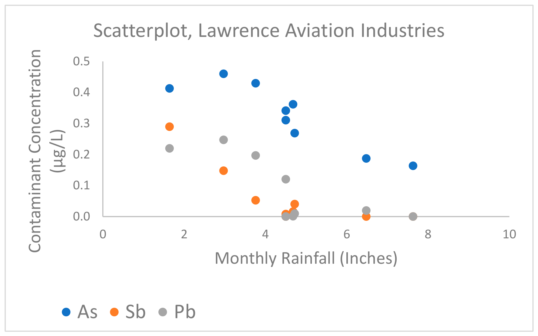
At the Lawrence Aviation site, samples were collected from an outflow pipe, following groundwater treatment of a shallow well. Negative associations were consistently observed between rainfall and contaminant concentrations for monthly rainfall totals. Three metals (As, Sb, and Pb) showed significant negative associations with rainfall over the prior month (Figure 3), and 15 of the 19 contaminants had negative β coefficients. There were similar, but weaker patterns for daily and weekly rainfall: a larger percentage of negative β coefficients were also noted (68–74%).

3.3. Other Sites

No consistent trends were observed in samples collected from Willetts Creek (Dzus Fasteners site) or Glen Cove Creek (Li Tungsten site). The sampling location for the Dzus Fasteners site is about 100 m downstream from the source. This may limit the sensitivity of our sampling approach. Glen Cove Creek is a tidal system, and tidal mixing may alter potential rainfall-related trends.

4. Discussion

Recent reviews have summarized evidence showing that flooding events can move large amounts of material from hazardous waste sites, including US Superfund sites, and that material often contains contaminants found on those sites, including metals, organics, and radioactive contaminants [5,6,13]. However, there are far fewer studies of contaminant mobility when the sites do not flood. This pilot study was designed to provide early data to test the hypothesis that rainfall causes changes in the concentrations of contaminants in water bodies near Superfund sites. A priori we wondered whether rainfall would dilute the concentrations in the water bodies, or if it would result in the release of contaminants from the soil reservoirs. We predicted the relationships may vary depending on the specific sites and the redox chemistry in the soil and water bodies near the sites [9,10]; for this reason, we selected four different types of Superfund sites for this study.
We observed some evidence for a negative correlation between rainfall and contaminant concentrations at two sites although the hydrogeological processes are likely to be distinct. At Gowanus Canal, samples were collected directly from surface water; the negative associations for same-day and prior-day rainfall, likely reflect dilution effects of surface water during rainfall events, consistent with the response expected in a surface water body that receives direct stormwater inputs.
At the Lawrence Aviation site, the negative trends are consistent with a dilution effect, although the negative association was strongest with the past month’s rainfall which may reflect the lag time required for infiltrating rainfall to dilute the shallow aquifer before reaching the treatment outflow. The Lawrence Aviation extraction and treatment system discharges an estimated 500 gallons (approximately 2000 L) of treated groundwater daily into Old Mill Creek [16], establishing the substantial water volumes involved. Because of a mix of clay, sandy, and silty soil overlaying in this region of Long Island, estimates of vertical and horizontal groundwater flow conductivity vary widely [14], but the negative association between rainfall and contaminant concentrations was also observed, albeit weaker, for same-day or prior-day rainfall. Given the proximity of the sampling location to residential septic systems and the range of contaminants observed, we believe this suggests dilution of contaminants coming from the Superfund site as well as residential septic systems [23].
This pilot study presents some of the first data characterizing relationships between rainfall and contaminants in water bodies near Superfund sites. Even though the number of samples is relatively small, these early data chart the path for several possible next steps. First, we recommend sampling directly from a shallow well beneath a Superfund site, along with detailed information on the estimated time lag from rainfall to infiltration of the well. Our data was limited by sampling occurring adjacent to the site, but not directly on the site. Second, we also recommend a study of the redox characteristics of the groundwater–soil interface, and measures of groundwater level, flow velocity, and conductivity to aid with the interpretation of the role of redox conditions in influencing mobility of contaminants [24]. Third, if possible, sampling from wells along a transect, starting at the most contaminated part of the Superfund site, should also help clarify the dynamics of contaminants in response to rainfall. Fourth, a major challenge to such studies is the need to implement a rapid field sampling response to precipitation events. Considerable planning and resources are needed to overcome these challenges, and to help fill the information gap on the links between contaminant movement and climate-driven events.
There are several important limitations in this pilot study. We were only able to collect a small number of samples per site. Each site also showcased distinct hydrogeological processes hindering comparability across the sites. Our volunteer-based deployment led to irregular temporal coverage in sampling. In addition, sampling occurred adjacent to, rather than directly at, the sites. These limitations affect our ability to determine the relative impacts of mobilization vs. dilution of contaminants in relation to rainfall. We are also limited by our focus on sites within a single geographic region.

5. Conclusions

These pilot data suggest the possibility of dilution of contaminants near some Superfund sites after heavy rainfall events. Given the increased frequency and intensity of storm events, it is important to continue to probe the links between rainfall and movement of contaminants in groundwater that might impact human exposure and health effects near old industrial waste sites. Future studies should include more Superfund sites across different geographic regions and hydrogeologic settings; increased sampling frequency, when possible; and rapid response for sampling around intense storms to better understand how changing precipitation patterns influence contaminant mobility and potential human exposure risks. In addition, we recommend sampling from multiple wells along a transect at a single Superfund site, to better clarify the dynamics of contaminants in response to rainfall.

Supplementary Materials

The following supporting information can be downloaded at: https://www.mdpi.com/article/10.3390/ijerph23091173/s1, Figure S1: Lawrence Aviation Site; Figure S2: Li Tungsten Site; Figure S3: Dzus Fasteners Superfund Site; Figure S4: Gowanus Canal; Figure S5: Example Newsletter for Sampling Prediction.

Author Contributions

Conceptualization, L.F.S., R.K., A.K.V., C.A.M., C.J.G., K.A.R., J.R.M.; methodology, L.F.S., B.H., R.K., A.K.V., C.A.M., K.A.R., J.R.M.; formal analysis, S.G.F., W.C.-R., J.C., X.Y., S.Y., A.K.V., C.A.M., K.A.R., J.R.M.; writing—original draft preparation, S.G.F., J.A., S.J., J.R.M.; writing—review and editing, W.C.-R., L.F.S., J.C., D.E.B., B.H., R.K., A.K.V., C.A.M., H.J.B., C.J.G., K.A.R., J.R.M.; supervision, K.A.R., J.R.M.; project administration, J.R.M.; funding acquisition, R.K., A.K.V., C.A.M., C.J.G., K.A.R., J.R.M. All authors have read and agreed to the published version of the manuscript.

Funding

This research was funded by Stony Brook University, Office of the Provost, Pilot Award for Climate Change Research.

Institutional Review Board Statement

Not applicable.

Informed Consent Statement

Not applicable.

Data Availability Statement

The original data presented in this study are included in the Supplementary Material. Further inquiries can be directed to the corresponding author.

Acknowledgments

Thank you to the Huntington Breast Cancer Action Coalition and Maxwell Bergman for supporting sampling efforts in Glen Cove, NY, during summer 2023. We also thank Adrienne Popescu for collecting samples from Glen Cove Creek associated with the Li Tungsten site.

Conflicts of Interest

All authors declared that there are no conflicts of interest.

References

  1. Amolegbe, S.M.; Lopez, A.R.; Velasco, M.L.; Carlin, D.J.; Heacock, M.L.; Henry, H.F.; Trottier, B.A.; Suk, W.A. Adapting to Climate Change: Leveraging Systems-Focused Multidisciplinary Research to Promote Resilience. Int. J. Environ. Res. Public Health 2022, 19, 14674. [Google Scholar] [CrossRef] [Scilit] [PubMed]
  2. U.S. Environmental Protection Agency. What Is Superfund? 2025. Available online: https://www.epa.gov/superfund/what-superfund (accessed on 26 March 2026).
  3. Summers, K.; Lamper, A.; Buck, K. National Hazards Vulnerability and the Remediation, Restoration and Revitalization of Contaminated Sites—1. Superfund. Environ. Manag. 2021, 67, 1029–1042. [Google Scholar] [CrossRef] [Scilit] [PubMed]
  4. Dougherty, J. Past, Present, and Future: Superfund, Climate Change, and Environmental Justice. Master’s Thesis, Tufts University, Medford, MA, USA, 2024. [Google Scholar]
  5. Crawford, S.E.; Brinkmann, M.; Ouellet, J.D.; Lehmkuhl, F.; Reicherter, K.; Schwarzbauer, J.; Bellanova, P.; Letmathe, P.; Blank, L.M.; Weber, R.; et al. Remobilization of Pollutants during Extreme Flood Events Poses Severe Risks to Human and Environmental Health. J. Hazard. Mater. 2022, 421, 126691. [Google Scholar] [CrossRef] [Scilit] [PubMed]
  6. Förstner, U.; Hollert, H.; Brinkmann, M.; Eichbaum, K.; Weber, R.; Salomons, W. Dioxin in the Elbe River Basin: Policy and Science under the Water Framework Directive 2000–2015 and toward 2021. Environ. Sci. Eur. 2016, 28, 9. [Google Scholar] [CrossRef] [Scilit] [PubMed]
  7. Grifoll, J.; Cohen, Y. Contaminant Migration in the Unsaturated Soil Zone: The Effect of Rainfall and Evapotranspiration. J. Contam. Hydrol. 1996, 23, 185–211. [Google Scholar] [CrossRef] [Scilit]
  8. Libera, A.; De Barros, F.P.J.; Faybishenko, B.; Eddy-Dilek, C.; Denham, M.; Lipnikov, K.; Moulton, D.; Maco, B.; Wainwright, H. Climate Change Impact on Residual Contaminants under Sustainable Remediation. J. Contam. Hydrol. 2019, 226, 103518. [Google Scholar] [CrossRef] [Scilit] [PubMed]
  9. Wade, A.M.; Eckley, C.S.; Noerpel, M.; Goetz, J.; Leptich, D.; Prestbo, K.; Van De Riet, D.; Sluka, S.; Wilkin, R.; Luxton, T.P. Mobilization of Porewater Pb and Zn in Response to Seasonal Wetting and Drying within Contaminated Floodplains. Sci. Total Environ. 2025, 958, 178053. [Google Scholar] [CrossRef] [Scilit] [PubMed]
  10. Wei, Y.; Xu, X.; Zhao, L.; Chen, X.; Qiu, H.; Gao, B.; Cao, X. Migration and Transformation of Chromium in Unsaturated Soil during Groundwater Table Fluctuations Induced by Rainfall. J. Hazard. Mater. 2021, 416, 126229. [Google Scholar] [CrossRef] [Scilit] [PubMed]
  11. Hill, K.; Hirschfeld, D.; Lindquist, C.; Cook, F.; Warner, S. Rising Coastal Groundwater as a Result of Sea-Level Rise Will Influence Contaminated Coastal Sites and Underground Infrastructure. Earths Future 2023, 11, e2023EF003825. [Google Scholar] [CrossRef] [Scilit]
  12. Izaditame, F.; LeMonte, J.J.; Siebecker, M.G.; Yu, X.; Fischel, M.; Tappero, R.; Sparks, D.L. Sea−level Rise and Arsenic−rich Soils: A Toxic Relationship. J. Hazard. Mater. 2024, 472, 134528. [Google Scholar] [CrossRef] [Scilit] [PubMed]
  13. Ponting, J.; Kelly, T.J.; Verhoef, A.; Watts, M.J.; Sizmur, T. The Impact of Increased Flooding Occurrence on the Mobility of Potentially Toxic Elements in Floodplain Soil—A Review. Sci. Total Environ. 2021, 754, 142040. [Google Scholar] [CrossRef] [Scilit] [PubMed]
  14. Schubert, C.E. Ground-Water Flow Paths and Traveltime to Three Small Embayments Within the Peconic Estuary, Eastern Suffolk County, New York; US Department of the Interior, US Geological Survey: Reston, VA, USA, 1999. [Google Scholar]
  15. Bakatsias, D.E.; Kaur, J.; Parlapall, T.; Soares, L.F.; Venkatesan, A.K.; Karimi, R.; Reed, K.A.; Meliker, J.R. Impact of Rainfall, Snowpack and Storms on Contaminant Levels in Groundwater beneath Two U.S. Superfund Sites in New York. J. Environ. Expo. Assess. 2025, 4, 39. [Google Scholar] [CrossRef] [Scilit]
  16. United States Environmental Protection Agency Record of Decision. Lawrence Aviation Industries, Inc. Superfund Site, Port Jefferson Station, Suffolk County, New York; United States Environmental Protection Agency: Washington, DC, USA, 2006; p. 57. [Google Scholar]
  17. United States Environmental Protection Agency Record of Decision Amendment. Li Tungsten Superfund Site, Glen Cove, Nassau County, New York; Environmental Protection Agency: New York, NY, USA, 2016. [Google Scholar]
  18. New York State Department of Environmental Conservation Record of Decision. Dzus Fastener Co., Inc. Operable Unit 03—Willetts Creek Wetland Areas, West Islip, Suffolk County, New York (Site No. 152033); New York State Department of Environmental Conservation: Albany, NY, USA, 2017. [Google Scholar]
  19. United States Environmental Protection Agency. Record of Decision: Gowanus Canal Superfund Site, Brooklyn, Kings County, New York; United States Environmental Protection Agency: New York, NY, USA, 2013; p. 96. [Google Scholar]
  20. National Oceanic and Atmospheric Administration. Climate and Weather Information; National Weather Service: Silver Spring, MD, USA, 2026; Available online: https://dex.cocorahs.org/ (accessed on 26 March 2026).
  21. Reed, A.T.; Stansfield, A.M.; Reed, K.A. Characterizing Long Island’s Extreme Precipitation and Its Relationship to Tropical Cyclones. Atmosphere 2022, 13, 1070. [Google Scholar] [CrossRef] [Scilit]
  22. Munch, J.W.; Paul, G. Grimmet Method 522—Determination of 1,4-Dioxane in Drinking Water by Solid Phase Extraction (SPE) and Gas Chromatography Mass Spectrometry (GC/MS) with Selected Ion Monitoring (SIM); Environmental Protection Agency: New York, NY, USA, 2008. [Google Scholar]
  23. Lee, C.-S.; Asato, C.; Wang, M.; Mao, X.; Gobler, C.J.; Venkatesan, A.K. Removal of 1,4-Dioxane during on-Site Wastewater Treatment Using Nitrogen Removing Biofilters. Sci. Total Environ. 2021, 771, 144806. [Google Scholar] [CrossRef] [Scilit] [PubMed]
  24. Meliker, J.R.; Slotnick, M.J.; Avruskin, G.A.; Haack, S.K.; Nriagu, J.O. Influence of Groundwater Recharge and Well Characteristics on Dissolved Arsenic Concentrations in Southeastern Michigan Groundwater. Environ. Geochem. Health 2009, 31, 147–157. [Google Scholar] [CrossRef] [Scilit] [PubMed]
Figure 1. Location of four selected Superfund Sites on Long Island, New York. The white, dashed line shows the approximate location of the groundwater divide based on the elevation of the water table. Groundwater flows approximately north or south away from the divide (blue arrows) curving to intersect the local shoreline perpendicularly. White arrows show the local direction of groundwater flow at each study site.
Ijerph 23 01173 g001
Figure 2. Time series depicting the relationship between groundwater concentrations of Mo and yesterday’s rainfall at Li Tungsten in Glen Cove, NY.
Ijerph 23 01173 g002
Figure 3. Scatterplot showing the relationship between groundwater concentrations of As, Sb, and Pb and monthly rainfall at Lawrence Aviation Industries in Port Jefferson, NY.
Ijerph 23 01173 g003
Table 1. Sampling strategy at each site, December 2022 to September 2023.
Superfund SiteSampling SiteNo. of Days of Sampling
Lawrence Aviation Industries (Port Jefferson, NY, USA)Groundwater is extracted and treated with five extraction wells, air stripping, and two liquid-phase granulated activated-carbon unit filtration. The treated effluent is discharged to Old Mill Creek, and water samples were collected directly from the treated outflow discharge source, prior to entering the creek.24
Li Tungsten (Glen Cove Creek, Glen Cove, NY, USA)Samples were collected near the creek’s bulkhead, where groundwater flows into Glen Cove Creek and is discharged (Supplemental Figure S2).15
Dzus Fasteners Co. Inc. (Willetts Creek, West Islip, NY, USA)Groundwater flows 3 m below the site and emerges as Willetts Creek. Water samples from Willetts Creek were collected approximately 100 m south of the site in collaboration with West Islip High School students (Supplemental Figure S3).11
Gowanus Canal (Brooklyn, NY, USA)Surface water samples were obtained from a bridge using a sampling cup attached to a fishing rod (Supplemental Figure S4). 16
Table 2. Descriptive statistics of contaminant levels (µg/L) in water from 4 Superfund sites on Long Island, NY, 2022–2023 (N = 66).
ContaminantMethod Detection Limit (MDL)MedianMinimumMaximum% Detect
Be0.010.040.020.1814%
Mn0.011.420.0123187%
Co0.020.130.020.8288%
Zn0.0920.620.3113193%
As0.090.410.056.7591%
Se0.050.410.0510.354%
Sr*118.850.16403096%
Mo*0.800.0111893%
Cd0.010.050.013.4679%
Sn*2.680.0316972%
Sb0.010.190.011.3678%
Cs*0.120.01572090%
Ba0.0132.490.8616195%
Pt*0.010.010.2114%
Hg*0.970.206.7772%
Tl0.010.030.010.9776%
Pb0.010.090.011.6583%
U*0.100.012.6394%
1,4-dioxane0.040.040.041.1880%
* Analytes measured semi-quantitatively.
Table 3. Associations between contaminants and rainfall at four Superfund sites on Long Island, New York.
ContaminantToday’s RainfallYesterday’s RainfallLast Week’s RainfallLast Month’s Rainfall
βp-Valueβp-Valueβp-Valueβp-Value
Glen Cove Creek, Li Tungsten
Be−0.150.93−0.700.751.230.381.250.57
Mn2.620.75−6.570.56−0.090.99−8.380.42
Co−1.460.80−4.620.51−0.420.93−1.730.83
Zn2.020.90−13.120.55−6.870.64−7.950.30
As0.0260.993.000.444.60.043.830.19
Se−0.200.50−0.600.130.070.620.120.60
Sr210.60.62−921.10.07117.50.75−17.40.97
Mo−0.950.779.710.011.370.67−0.830.83
Cd−0.0860.470.020.910.020.870.030.84
Sn−11.640.75−14.110.77−8.230.84−5.630.93
Sb0.0620.780.590.030.050.80−0.130.58
Cs0.0090.71−0.060.03−0.0040.89−0.010.72
Ba−7.210.43−5.670.68−14.430.05−2.850.77
Pt−0.0010.72−0.0020.60−0.0010.79--
Hg0.470.38−0.480.550.520.520.360.60
Tl−4.420.70−1.980.908.510.419.540.45
Pb0.0450.360.060.420.0520.150.030.53
U−0.0870.820.020.970.0590.89−0.040.94
1,4-dioxane−0.0810.600.240.240.0850.55−0.040.85
Gowanus Canal
Be−0.010.36−0.020.27−0.0080.21−0.0020.77
Mn−3.310.293.220.510.270.91.020.68
Co−0.120.03−0.060.50−0.050.2−0.010.81
Zn0.170.973.860.531.600.540.420.89
As0.100.44−0.090.670.060.50.010.95
Se−0.430.60−0.710.58−0.440.41−0.340.59
Sr−616.00.07−390.95−199.010.41−85.520.75
Mo−1.400.07−0.570.65−0.300.580.050.93
Cd−0.0060.74−0.010.64−0.0030.780.0010.96
Sn−3.880.304.050.49−0.960.711.710.56
Sb0.070.10−0.120.03−0.0110.80−0.0060.82
Cs−0.080.02−0.040.55−0.0320.210.010.83
Ba1.810.38−3.320.290.970.50−0.040.97
Pt−0.00030.99−0.010.730.00160.900.020.24
Hg−0.360.65−1.060.28−0.680.240.270.59
Tl−0.050.51−0.090.44−0.0530.28−0.040.51
Pb−0.080.550.170.380.100.220.100.30
U−0.690.01−0.190.67−0.190.34−0.010.95
1,4-dioxane0.100.35−0.130.320.0200.790.020.50
Lawrence Aviation Industries
Be−0.0120.490.010.63−0.0040.72−0.0050.71
Mn0.0890.54−0.200.20−0.0560.45−0.020.39
Co0.0150.35−0.010.630.0030.740.0060.32
Zn−7.520.213.990.55−2.50.42−5.870.14
As−0.0740.020.0020.97−0.0370.03−0.050.00
Se−0.250.07−0.040.78−0.110.12−0.040.65
Sr−0.170.99−17.730.184.300.561.910.84
Mo−6.740.60−9.310.43−7.070.210.030.41
Cd−0.00410.580.0020.81−0.00260.49−0.0050.3
Sn11.580.60−6.810.72−16.260.10−19.320.11
Sb−0.0440.51−0.070.30−0.0510.12−0.0440.01
Cs184.30.52−194.00.44−192.020.15−234.90.12
Ba−1.620.71−0.370.94−0.550.813.660.13
Pt0.00010.980.0030.360.00070.68−0.0010.73
Hg1.570.33−1.10.32−1.120.08−1.990.06
Tl−0.0120.700.030.360.00150.92−0.020.39
Pb−0.0170.61−0.010.77−0.0220.20−0.050.02
U−0.0150.31−0.010.64−0.0150.02−0.010.06
1,4-dioxane−0.0630.250.010.930.00590.83−0.010.73
Willet’s Creek, Dzus Fasteners
Be--------
Mn14.790.87−22.70.64−28.30.30−14.670.62
Co0.0120.720.020.270.0020.830.010.41
Zn−9.700.83−24.50.31−17.70.20−20.10.15
As−0.00031.00−0.040.50−0.0350.24−0.020.60
Se−0.0640.580.080.180.0260.480.040.26
Sr20.510.6328.480.2811.780.5112.780.42
Mo−0.0950.570.0040.970.0970.150.050.41
Cd0.670.60−0.070.92−0.370.42−0.090.85
Sn−7.160.65−7.50.440.090.99−2.120.73
Sb0.0150.73−0.030.21−0.0200.18−0.010.43
Cs−1094.80.65−203.80.89−685.620.49−46.60.96
Ba−23.90.60−9.570.70−0.530.97−3.500.81
Pt--------
Hg−0.440.57−0.830.05−0.230.47−0.250.26
Tl−0.0120.78−0.0010.970.00730.600.0030.83
Pb−0.0190.730.040.210.00750.680.010.54
U−0.0260.550.010.640.0110.560.010.64
1,4-dioxane0.100.41−0.050.45−0.0170.68−0.010.68
Note: For ease of visualization, associations with p < 0.05 are shown in bold.
Disclaimer/Publisher’s Note: The statements, opinions and data contained in all publications are solely those of the individual author(s) and contributor(s) and not of MDPI and/or the editor(s). MDPI and/or the editor(s) disclaim responsibility for any injury to people or property resulting from any ideas, methods, instructions or products referred to in the content.