
A Methodology of Workshops to Explore Mutual Assistance Activities for Earthquake Disaster Mitigation


Abstract
1. Introduction
1.1. Background and Objective
1.2. Previous Studies
- (a)
- The features that are difficult to cross, such as rivers, railroad tracks, and wide trunk roads were not considered for evaluating mutual assistance map.
- (b)
- The building and the disaster situation (fire spread and rubble generation) were not constructed using a grid cell model, and the evacuation route was not constructed using a network model. For this, precise evaluation is difficult.
- (c)
- The results of the fire spread/road blockage model are changed by each simulation. This made it impossible to perform a fixed simulation of the disaster situation.
2. Materials and Methods
2.1. Examination of the Required Tool
- (a)
- First, local governments or experts evaluate the vulnerability to earthquakes at the city level, and identify the areas that need improvement.
- (b)
- Next, the local government approaches the neighborhood association to improve the issues.
- (c)
- After consensus building, concrete examination to improve the vulnerability of the area is explored by the residents and local government.
- i.
- Quantitatively evaluate and analyze mutual assistance capability by visual representation.
- ii.
- Promote an understanding of the importance of mutual assistance among residents.
- iii.
- Support the examination of community-based activities, considering mutual assistance.
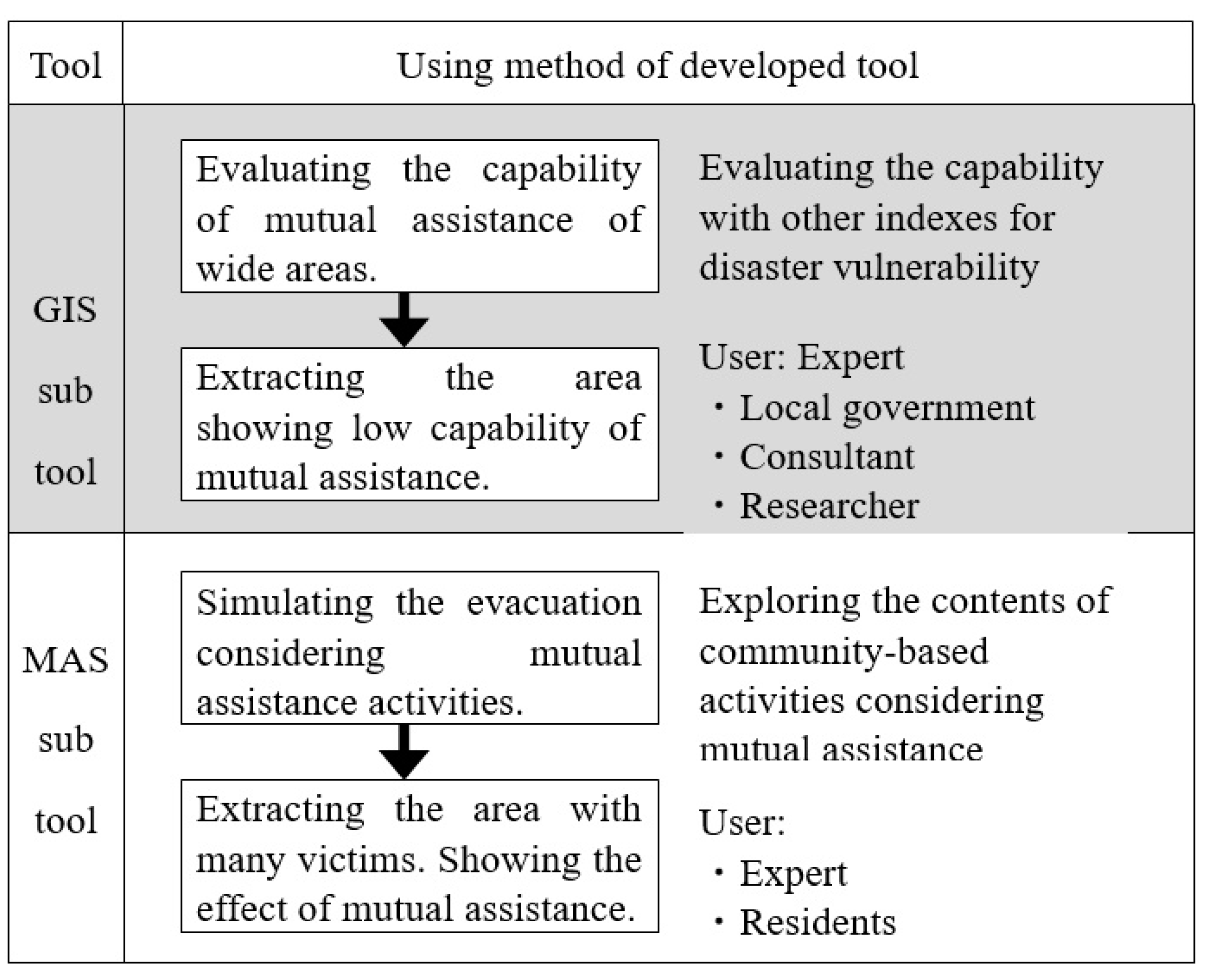
2.2. Structure of the Tool
2.3. GIS Sub-Tool
2.3.1. Evaluation Method
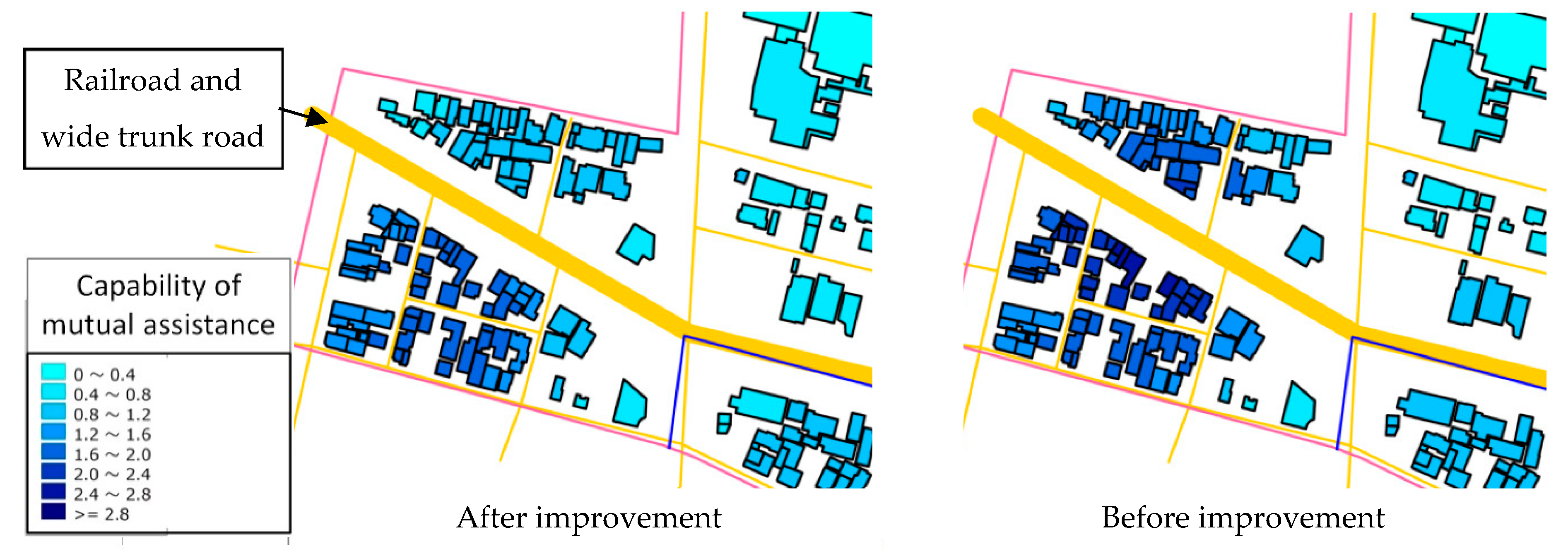
2.3.2. The Features That Are Difficult to Cross
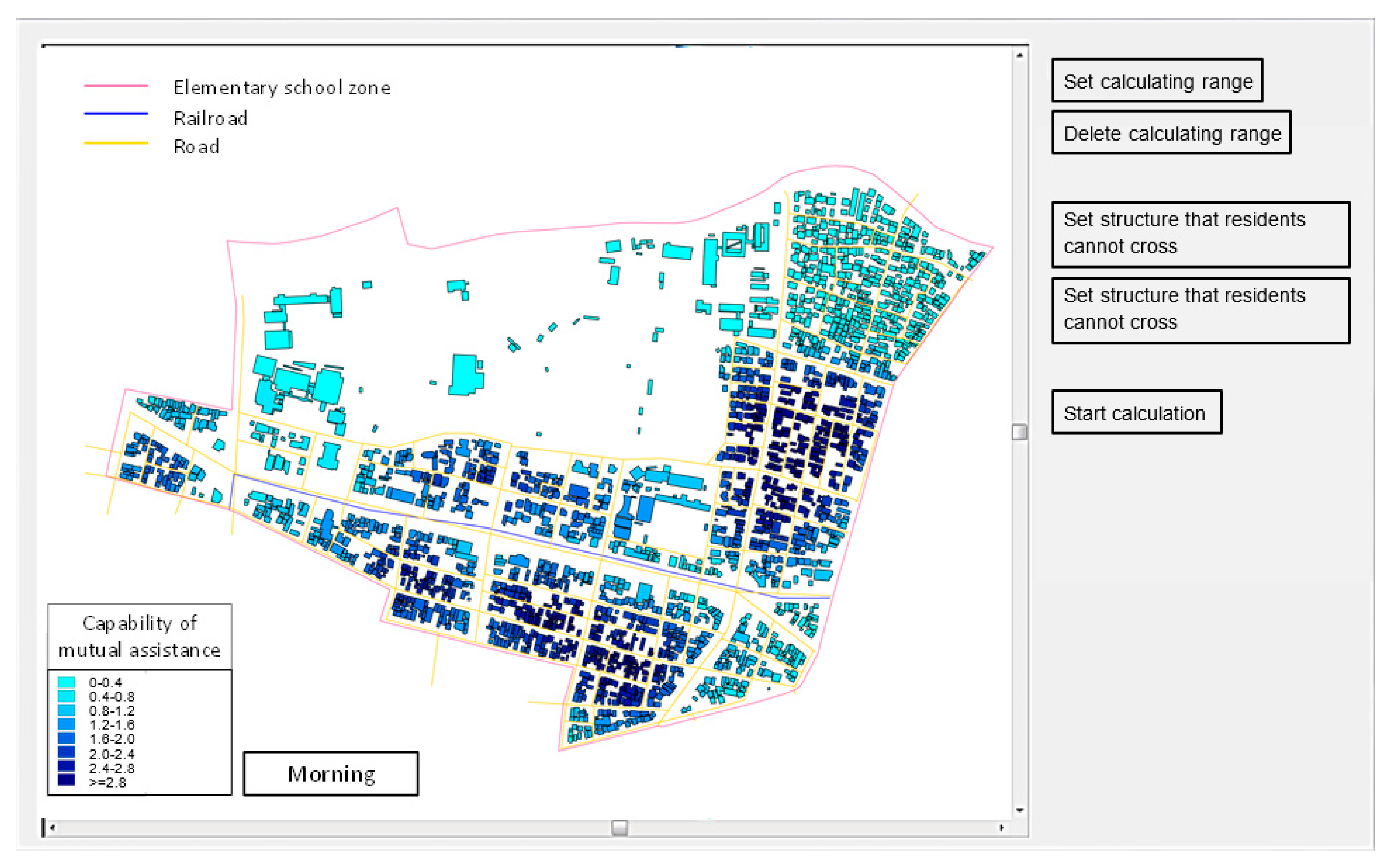
2.3.3. Using an Interface Method
2.4. MAS Sub-Tool
2.4.1. Agent
2.4.2. Structure of Simulator
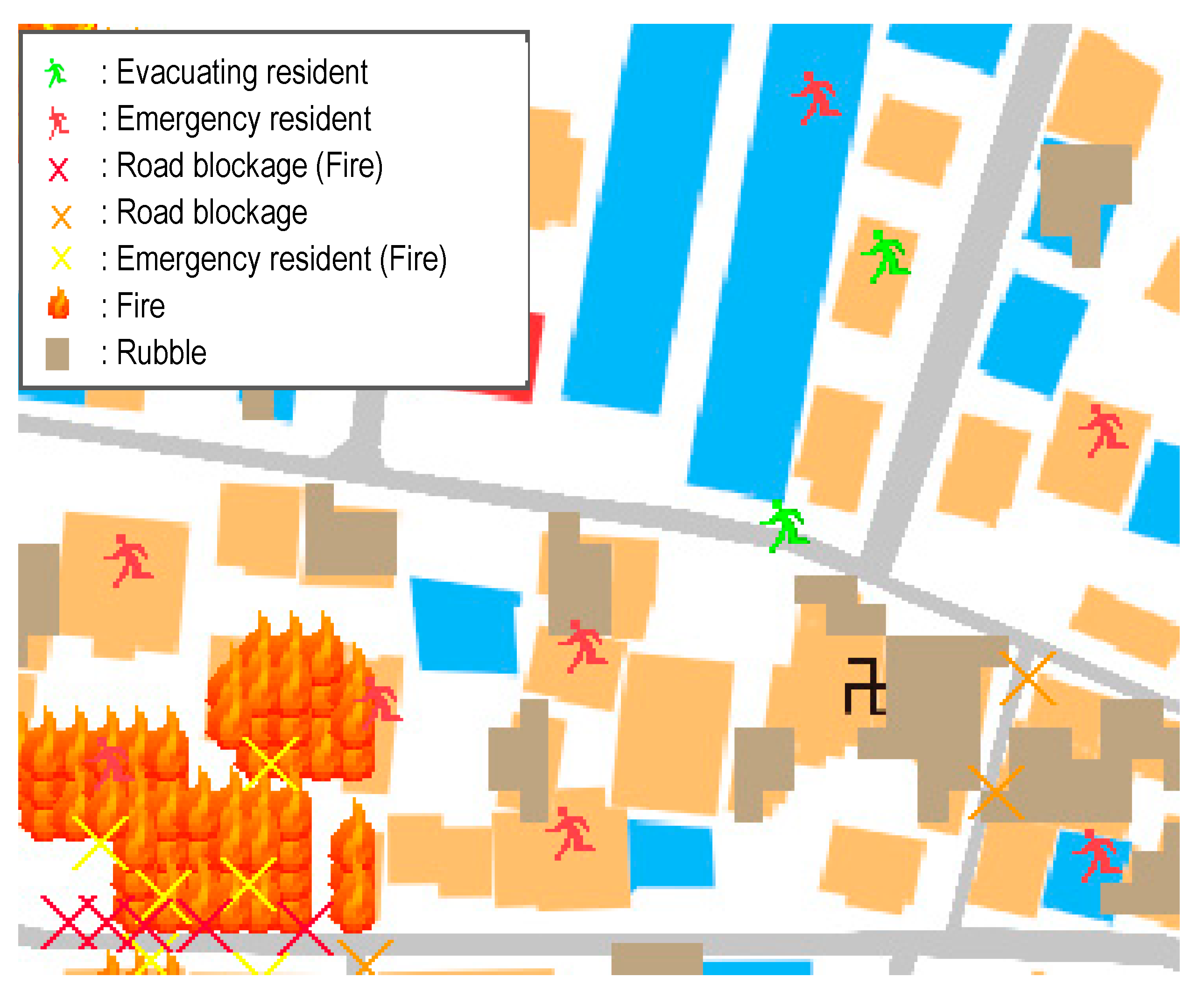
2.4.3. Road Blockage Model
2.4.4. Fire Spread Model
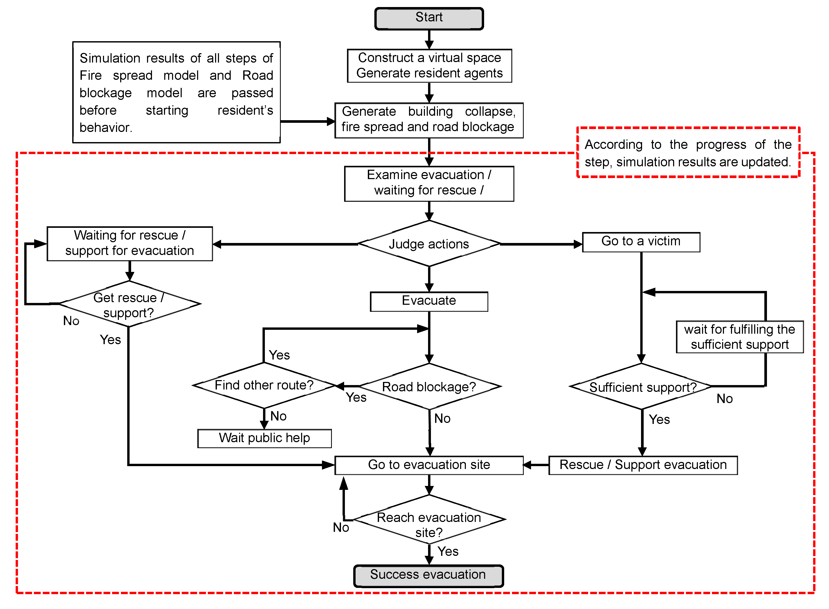
2.4.5. Behavior of Resident Agent
- (1)
- Evacuation: each resident agent evacuated from each building to the designated evacuation site. In this model, senior children in elementary school (10 and older) were able to evacuate alone. Children less than 10 years old evacuated with his/her parent.
- (2)
- Waiting rescue: the resident agent who was buried under a collapsed building would wait for help. The resident agent who was in a burning building had no support from other resident agents, because in the real world, it is difficult for residents to rescue someone who delays escaping from a fire.
- (3)
- Rescue victims: when resident agents discovered a victim in need of help within the perception range (the range that residents can find a person who requires mutual assistance) during evacuation, they took part in the rescue activity. However, resident agents with children less than 10 years of age were given priority in evacuation. When the total expected value of resident agents participating in rescue activities exceeded 1, they could rescue a victim. When the total expected value was not greater than 1 after a lapse of 5 min from earthquake generation, the resident agent gave up rescue and restarted evacuation.
- (4)
- Those in need of evacuation support: the residents who could not evacuate individually, such as elderly people and disabled people, waited for other residents’ help.
- (5)
- Those supporting evacuation: When resident agents discovered a resident in need of evacuation support within the perception range, they provided evacuation support. However, resident agents with children less than 10 years of age were given priority.
- (6)
- Awaiting public support: in the following three situations, resident agents could evacuate, even when performing mutual assistance activities. Therefore, when residents are in the following situations, they should wait on support from public institutions, such as the local fire or rescue teams: (1) a resident agent in a burning building; (2) a resident agent who cannot be rescued by another in situations where the total expected value is not greater than 1; (3) a resident agent who cannot reach the designated evacuation site due to road blockage.
2.4.6. Improvement of the Structure
2.4.7. Simulation Flow
2.4.8. Interface
- (1)
- Evacuation start time: the time from earthquake generation to starting evacuation.
- (2)
- Perception range: the range of residents’ capability to discover individuals who require mutual assistance.
- (3)
- Evacuation speed: the walking speed of a resident in evacuation.
- (4)
- Ratio of resident agents who require evacuation assistance: the ratio of resident agents who require evacuation assistance for each age group.
- (5)
- Mutual assistance setting for children aged 10 to 15: whether or not the setting item performs mutual assistance for children aged 10 to 15 years.
- (6)
- Road blockage setting: item to be set to select whether the road is closed by an earthquake or fire.
2.5. Examination of the Method to Explore a CDMP
3. Results
3.1. Demonstration for Evaluating Revised Tool
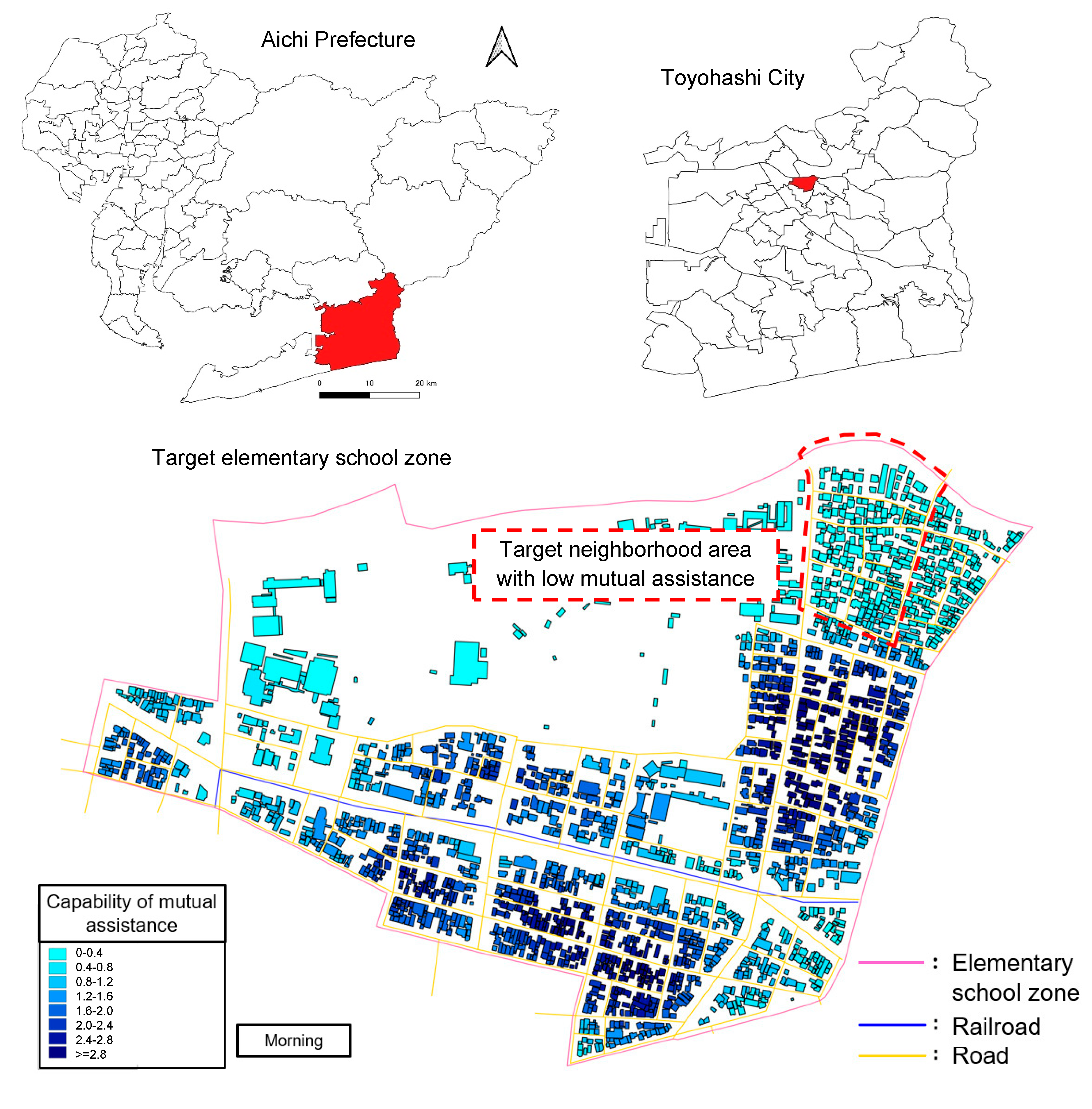
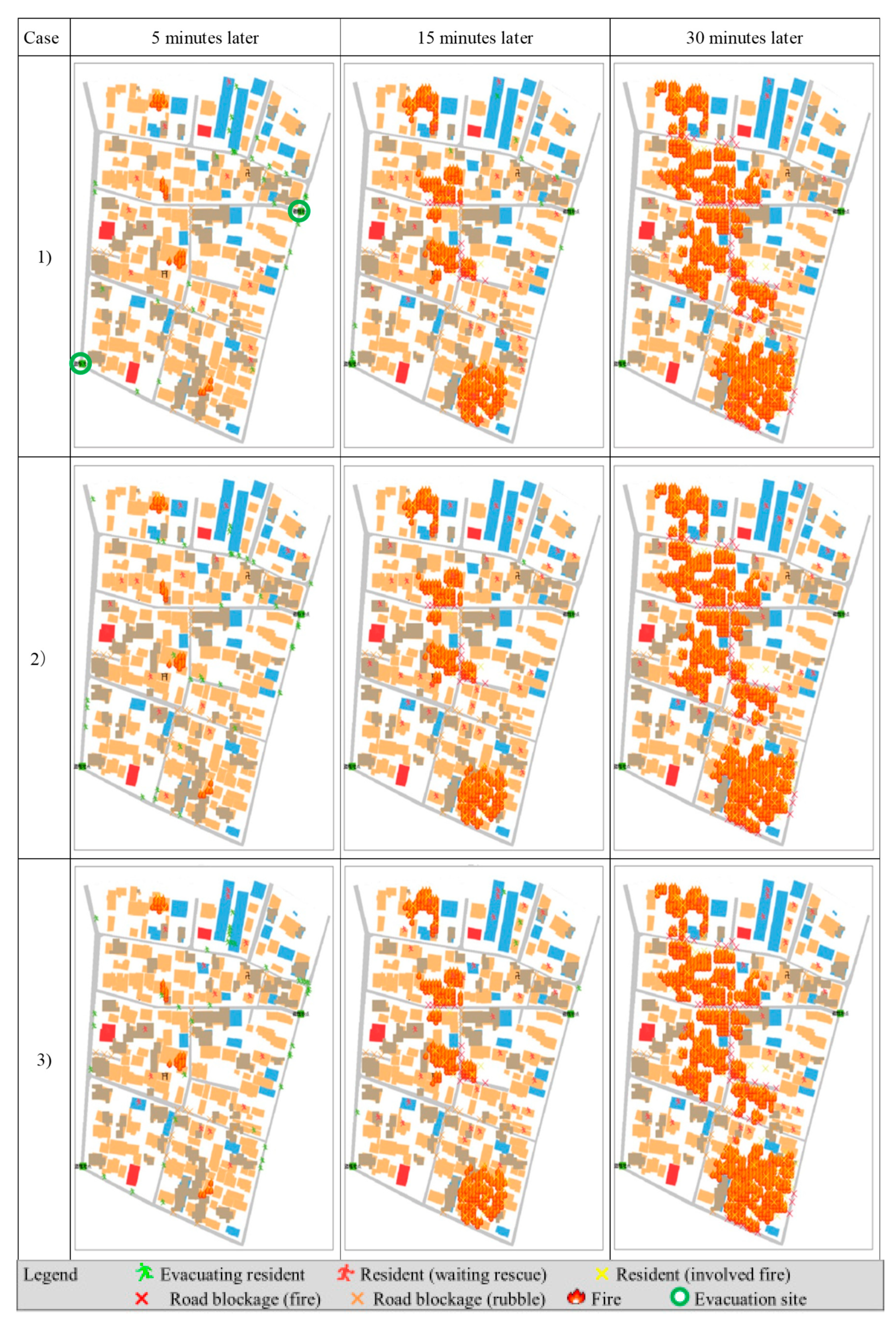
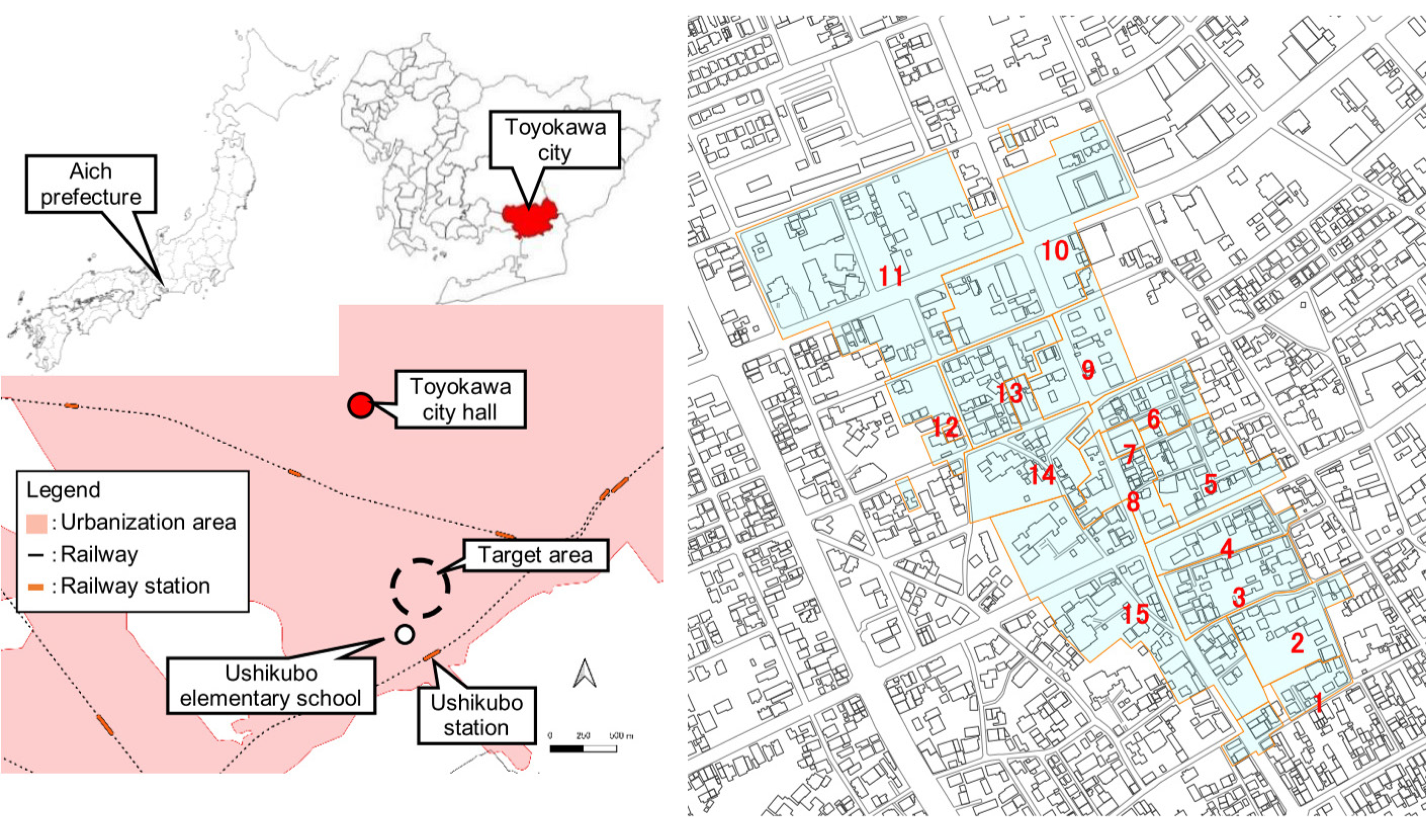
3.1.1. Target Area and Parameters
3.1.2. Data for Evaluating the Revised Tool
3.1.3. Analysis of the Results
3.1.4. Evaluation of the Tool
3.2. Evaluating the Method to Explore a CDMP
3.2.1. Outline of the Target Area
3.2.2. Pre-Study Workshop
- Using a GIS sub-tool—there is no problem making it.
- In regards to the MAS sub-tool, the simulation result seems to include privacy information. Due to the concerns, obtaining consensus among residents of the neighborhood association is necessary before using it.
3.2.3. Questionnaire for Data Collection
3.2.4. Examination of the Draft of CDMP
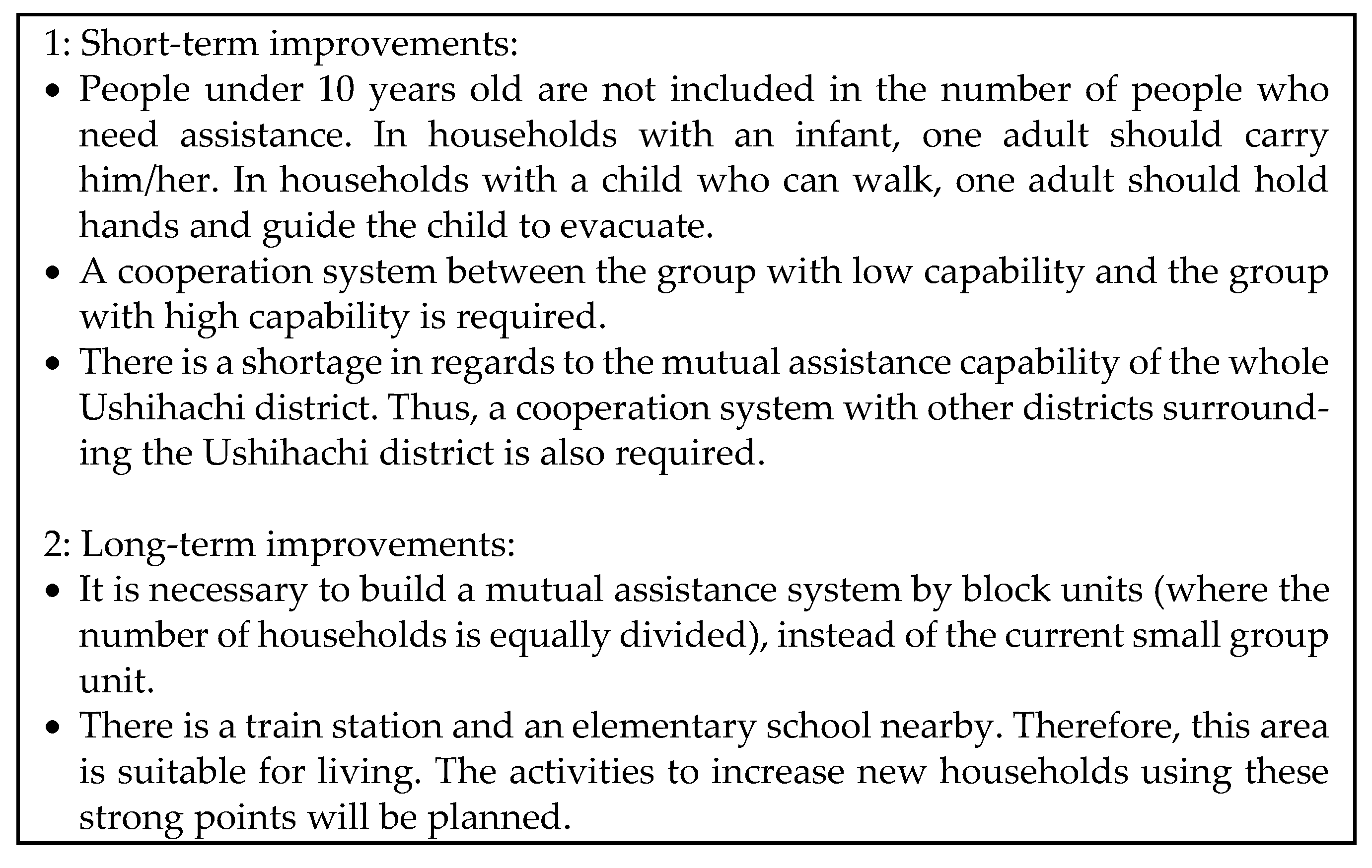
- The definition of the person who needs help seems to be too wide. For example, people under 10 years old should exempt from the number of people who need assistance. If it is an infant, it can be carried by one adult. If the individual is older than an infant who can walk, then one adult can hold hands with the individual and guide him/her to evacuate.
- Many young households do not belong to the neighborhood association. If they participate in the association’s activity, it will lead to the improvement of mutual assistance capability.
- There are points of consideration to explore concerning the support method used for the individual in need of help. One is the high aging rate of the whole district. The other is that the number of households, by the small group unit, is largely different.
- It is necessary to build a mutual assistance system by block unit (where the number of households is equally divided), instead of the current small group unit.
- A cooperation system between the group with low capability and the group with high capability is required.
- There is a shortage concerning the mutual assistance capabilities of the whole Ushihachi district. Thus, a cooperation system with other districts surrounding the Ushihachi district is also required.
3.2.5. Revision of the Draft of CDMP
4. Discussion
Questionnaire Survey to Residents
5. Conclusions
Author Contributions
Funding
Institutional Review Board Statement
Informed Consent Statement
Conflicts of Interest
References
- Cabinet Office, Government of Japan. Survey Report about Mutual Assistance Activities of Great East Japan Earthquake. 2013. Available online: http://www.bousai.go.jp/kaigirep/kentokai/hisaishashien2/pdf/dai2kai/sankou8.pdf (accessed on 20 February 2020).
- Disaster Countermeasures Basic Act. 2016. Available online: https://www.jda.or.jp/dentist/disaster/pdf/Disaster_Countermeasures.pdf (accessed on 20 February 2021).
- The Japan Society of Community Disaster Management Plan. 2014. Available online: https://gakkai.chiku-bousai.jp/english.html (accessed on 20 February 2021).
- Cabinet Office, Government of Japan. Community Disaster Management Plan for Everyone 2014. Available online: http://www.bousai.go.jp/kyoiku/chikubousai/ (accessed on 10 January 2021).
- Karashima, K.; Ohgai, A. An Evacuation Simulator for Exploring Mutual Assistance Activities in Neighborhood Communities for Earthquake Disaster Mitigation. Int. Rev. Spat. Plan. Sustain. Dev. 2018, 6, 18–31. [Google Scholar] [CrossRef]
- Karashima, K.; Ohgai, A.; Mukudai, T. A Tool to Explore Community-based Activities Considering Mutual Assis-tance for Earthquake Disaster Mitigation Using a Multi-agent System and GIS. In Proceedings of the 13th International Conference on Design and Decision Support Systems in Architecture and Urban Planning, Eindhoven, The Netherlands, 27–28 June 2016. [Google Scholar]
- Yoshii, H. Social impacts of earthquake prediction in Greece. Tectonophysics 1993, 224, 251–255. [Google Scholar] [CrossRef]
- Lazaridou-Varotsos, M.S. Earthquake Prediction by Seismic Electric Signals; Springer International Publishing: Berlin/Heidelberg, Germany, 2013. [Google Scholar]
- Kawata, Y. Prediction of Loss of Human Lives Due to Catastrophic Earthquake Disaster. Jpn. Soc. Nat. Disaster Sci. 1997, 16, 3–13. [Google Scholar]
- Akiyama, Y.; Ogawa, Y. An Evaluation Method for the Capability of Initial Response to Huge Earthquakes and a Proposal for the Policy of Disaster Mitigation in Japan. 2013. Available online: https://www.mlit.go.jp/common/000998389.pdf (accessed on 20 February 2021).
- Ogawa, Y.; Akiyama, Y.; Kanasugi, H.; Sengoku, H.; Shibasaki, R. Evaluating the Damage of Great Earthquakes in Aggregate Units Based on Detailed Population Distribution for Each Time Frame. In Proceedings of the CUPUM 2015, Cambridge, MA, USA, 7–10 July 2015; pp. 1–18. [Google Scholar]
- D’Orazio, M.; Spalazzi, L.; Quagliarini, E.; Bernardini, G. Agent-based model for earthquake pedestrians’ evacuation in urban outdoor scenarios: Behavioural patterns definition and evacuation paths choice. Saf. Sci. 2014, 62, 450–465. [Google Scholar] [CrossRef]
- Wagner, N.; Agrawal, V. An agent-based simulation system for concert venue crowd evacuation modeling in the presence of a fire disaster. Expert Syst. Appl. 2014, 41, 2807–2815. [Google Scholar] [CrossRef]
- Takabatake, T.; Shibayama, T.; Esteban, M.; Ishii, H.; Hamano, G. Simulated tsunami evacuation behavior of local residents and visitors in Kamakura, Japan. Int. J. Disaster Risk Reduct. 2017, 23, 1–14. [Google Scholar] [CrossRef]
- Wang, H.; Mostafizi, A.; Cramer, L.A.; Cox, D.T.; Park, H. An agent-based model of a multimodal near-field tsunami evacuation: Decision-making and life safety. Transp. Res. Part C Emerg. Technol. 2016, 64, 86–100. [Google Scholar] [CrossRef]
- Mostafizi, A.; Wang, H.; Cox, D.; Dong, S. An agent-based vertical evacuation model for a near-field tsunami: Choice behavior, logical shelter locations, and life safety. Int. J. Disaster Risk Reduct. 2019, 34, 467–479. [Google Scholar] [CrossRef]
- Osaragi, T.; Oki, T. Wide-Area Evacuation Simulation Incorporating Rescue and Firefighting by Local Residents. J. Disaster Res. 2017, 12, 296–310. [Google Scholar] [CrossRef]
- Oki, T.; Osaragi, T. Effects of rescue activities by local residents considering property damage and wide-area. In Proceedings of the 13th International Conference on Design and Decision Support Systems in Architecture and Urban Planning, Eindhoven, The Netherlands, 27–28 June 2016. [Google Scholar]
- Oki, T.; Osaragi, T. Simulation analysis of wide-area evacuation in densely built-up wooden residential areas after a large earthquake incorporating rescue activities by local residents. J. Arch. Plan. 2016, 81, 1345–1353. [Google Scholar] [CrossRef]
- Inaba, Y. Social Capital -What we have learned from Disasters and the Importance of Social Capital Surveys for Community Disaster Management Plans-. J. Jpn. Soc. Community Disaster Manag. Plan 2017, 8, 3–11. (In Japanese) [Google Scholar]
- Technical Committee on Densely Built-Up Residential Development. In Safety Community Planning Guide-Book; Sohjusha: Tokyo, Japan, 2008. (In Japanese)
- Tokyo Fire Department. Tokyo Metropolitan Government 16th Fire Prevention Council Report Elucidation of Disaster Crisis Factors and Countermeasures of Firefighting in Densely Populated Area at the Time of Earthquake; Tokyo Fire Department: Tokyo, Japan, 2005. (In Japanese)
- The Council for Disaster Mitigation of Toyohashi City. The Survey for Damage Prediction of Nankai trough Earthquake in Toyohashi City. 2014. Available online: https://www.city.toyohashi.lg.jp/16584.htm (accessed on 7 December 2020).
- Gohnai, Y.; Ohgai, A.; Ikaruga, S.; Kato, T.; Hitaka, K.; Murakami, M.; Watanabe, K. An evaluation method for emergency response activities during earthquakes in Japanese local cities: A tool for supporting community-based planning disaster mitigation. In Proceedings of the 10th International Conference in Computers in Urban Planning and Urban Management, Iguassu, Brazil, 11–13 July 2007. [Google Scholar]
- Ohgai, A.; Gohnai, Y.; Watanabe, K. Cellular automata modeling of fire spread in built-up areas—A tool to aid community-based planning for disaster mitigation. Comput. Environ. Urban Syst. 2007, 31, 441–460. [Google Scholar] [CrossRef]
- Japan Assosiation for Fire Science and Engineering. Handbook for Fire Science and Engineering; Kyoritsu Publisher: Tokyo, Japan, 1997. [Google Scholar]
- Ishido, S.; Nakane, H. Introduction of Residential Environment; Kagaku-Dojin: Tokyo, Japan, 1995. (In Japanese) [Google Scholar]
- Ministry of Health, Labour and Welfare (MHLW). Annual Health, Labour, and Welfare Report; MHLW: Tokyo, Japan, 2014. (In Japanese)
- Salas, J.; Yepes, V. Enhancing Sustainability and Resilience through Multi-Level Infrastructure Planning. Int. J. Environ. Res. Public Health 2020, 17, 962. [Google Scholar] [CrossRef] [PubMed]


| Age | Men’s Strength | Women’s Strength | Executing Rate | Men’s activity RATE | Women’s Activity Rate | Men’s Expected Value | Women’s Expected Value |
|---|---|---|---|---|---|---|---|
| 10 | 1 | 0.85 | 0.228 | 0.76 | 0.24 | 0.1733 | 0.0465 |
| 20 | 1 | 0.76 | 0.228 | 0.76 | 0.24 | 0.1733 | 0.0416 |
| 30 | 0.96 | 0.76 | 0.229 | 0.72 | 0.28 | 0.1583 | 0.0487 |
| 40 | 0.93 | 0.73 | 0.298 | 0.72 | 0.28 | 0.1995 | 0.0609 |
| 50 | 0.9 | 0.72 | 0.228 | 0.63 | 0.37 | 0.1293 | 0.0607 |
| 60 | 0.84 | 0.7 | 0.191 | 0.74 | 0.26 | 0.1187 | 0.0348 |
| 70- | 0.78 | 0.65 | 0.129 | 0.75 | 0.25 | 0.0755 | 0.021 |
| Step | Role of the Tools | Effect | Target |
|---|---|---|---|
| Step 1: pre-study workshop. Understanding the necessity for making CDMP. | A: Understanding the area with low capability. B: Understanding effect of mutual assistance activities. |
| Tool user: university consultant municipality Participants: residents |
| Step 2: questionnaire survey. Collecting the data for calculating the mutual assistance capability | A: Evaluating mutual assistance capability. |
| Tool user: university consultant municipality |
| Step 3: Workshop. Understanding capability in the current condition, of the target area, and exploring improvement. | A: Understanding the area with low capability. B: Understanding the place—of the household—with the residents who cannot receive help from neighbors. |
| Tool user: university consultant municipality. Participants: residents. |
| Step 4: Workshop. Exploring the countermeasures to reduce the residents who cannot receive help from neighbors. | A and B: Understanding the effect of the improvement. |
| Same as Step 3. |
| Parameters | Case 1 | Case 2 | Case 3 |
|---|---|---|---|
| Presence or absence of mutual assistance | presence | Absence | presence |
| Change in time | morning | morning | evening |
| Wind speed | 5 m/s | same | same |
| Wind direction | northwest | same | same |
| Evacuation speed [26] | 1.5 m/s | same | 1.0 m/s |
| Perception range [27] (*) | 15 m (5 cells) | 0 m (0 cell) | 9 m (3cells) |
| Ratio of residents who could not evacuate [28] (**) | 60–69: 0.1 70 & over: 0.2 other: 0.05 | same | same |
| Road obstruction by rubble (***) | passable | same | same |
| Road obstruction by fire | impassable | same | same |
| Agent can be out of the building at the time of the fire | no | same | same |
| Case | (a) Number of Residents | (b) (*) Total Number of Successful Evacuations | (c) Evacuation Success Rate (%) | (d) Number of People Requiring Mutual Assistance | (e) Total People Receiving Mutual Assistance | (f) Mutual Assistance Success Rate (%) |
|---|---|---|---|---|---|---|
| (1) | 398 | 2917 | 73.25 | 1085 | 148 | 13.58 |
| (2) | 398 | 2787 | 70.05 | 1105 | 0 | 0.00 |
| (3) | 301 | 2172 | 72.16 | 802 | 44 | 5.36 |
| 1 | 2 | 3 | 4 | 5 | 6 | 7 | 8 | 9 | 10 | Total | Average | |
|---|---|---|---|---|---|---|---|---|---|---|---|---|
| A | 293 | 296 | 287 | 290 | 289 | 295 | 293 | 296 | 291 | 287 | 2917 | 291.7 |
| B | 258 | 304 | 289 | 306 | 321 | 313 | 271 | 297 | 261 | 295 | 2915 | 291.5 |
| First Hearing-Based Survey: A | |
| Date | 18 January 2016 |
| Participants | Disaster mitigation division staff of Toyohashi City Urban planning division staff of Toyokawa City |
| Items |
|
| Second Hearing-Based Survey: B | |
| Date | 19 January 2017 |
| Participants | Fire department staff of Kobe City |
| Items |
|
| Evaluation | Comments |
|---|---|
| Usability | GIS sub-tool
|
MAS sub-tool
| |
| Validity | GIS sub-tool
|
MAS sub-tool
| |
| Issues |
|
| Q1: Number of persons in your household and the constitution. |
| Q2: Are there any persons who cannot evacuate and need someone’s help in your household? |
| Q3: Do you have enough persons to support him/her in your household? (If you answer “No” at Q2, please skip this.) |
| Q4: Are there any persons who cannot evacuate and need someone’s help in your neighborhood (exclude your household)? |
| Q5: Are there any persons who can support the person mentioned above (Q4) in your household? (If you answer “No” at Q4, please skip this.) |
| Q6: Which distance can you support the person mentioned at Q4? |
| Q7: If possible, could you mark your house in the below map? |
| Q8: Could you tell us any opinion about the answers mentioned above, if you feel? |
| Items | The Number of Small Groups | Total | ||||||||||||||
|---|---|---|---|---|---|---|---|---|---|---|---|---|---|---|---|---|
| 1 | 2 | 3 | 4 | 5 | 6 | 7 | 8 | 9 | 10 | 11 | 12 | 13 | 14 | 15 | ||
| (1): People who need assistance | 6 | 2 | 6 | 1 | 1 | 3 | 2 | 0 | 3 | 5 | 6 | 5 | 2 | 3 | 2 | 47 |
| (2): Pople under 10 years old | 0 | 0 | 2 | 0 | 0 | 1 | 2 | 0 | 0 | 1 | 3 | 2 | 0 | 1 | 2 | 14 |
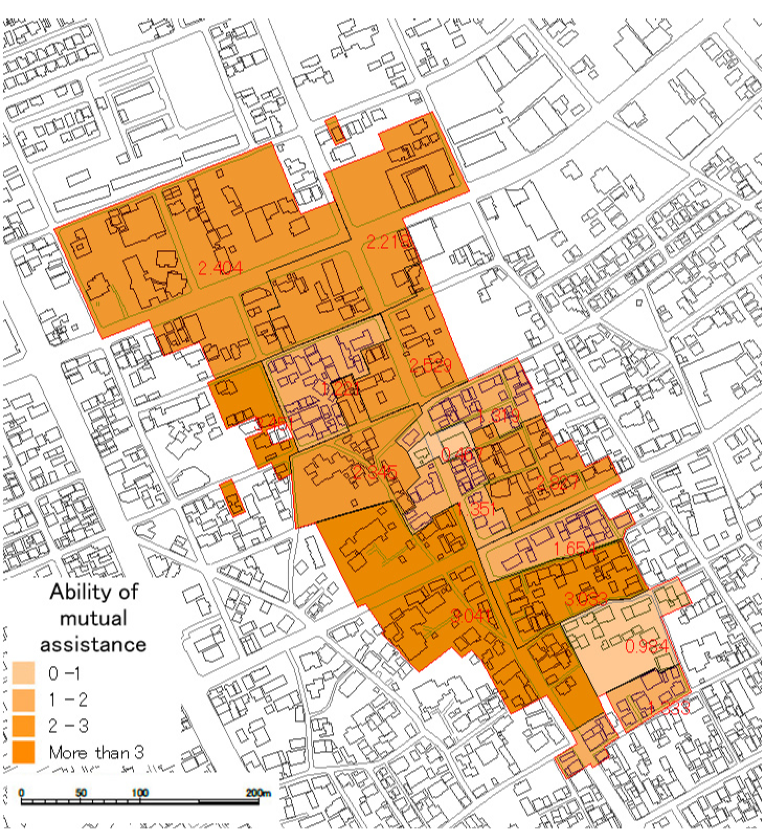
| (3): Ability of mutual assistance | 1.3327 | 0.9839 | 3.0331 | 1.6542 | 2.8272 | 1.3194 | 0.4674 | 1.3514 | 2.5286 | 2.2181 | 2.4041 | 3.451 | 1.2214 | 2.3447 | 3.0414 | 30.179 |
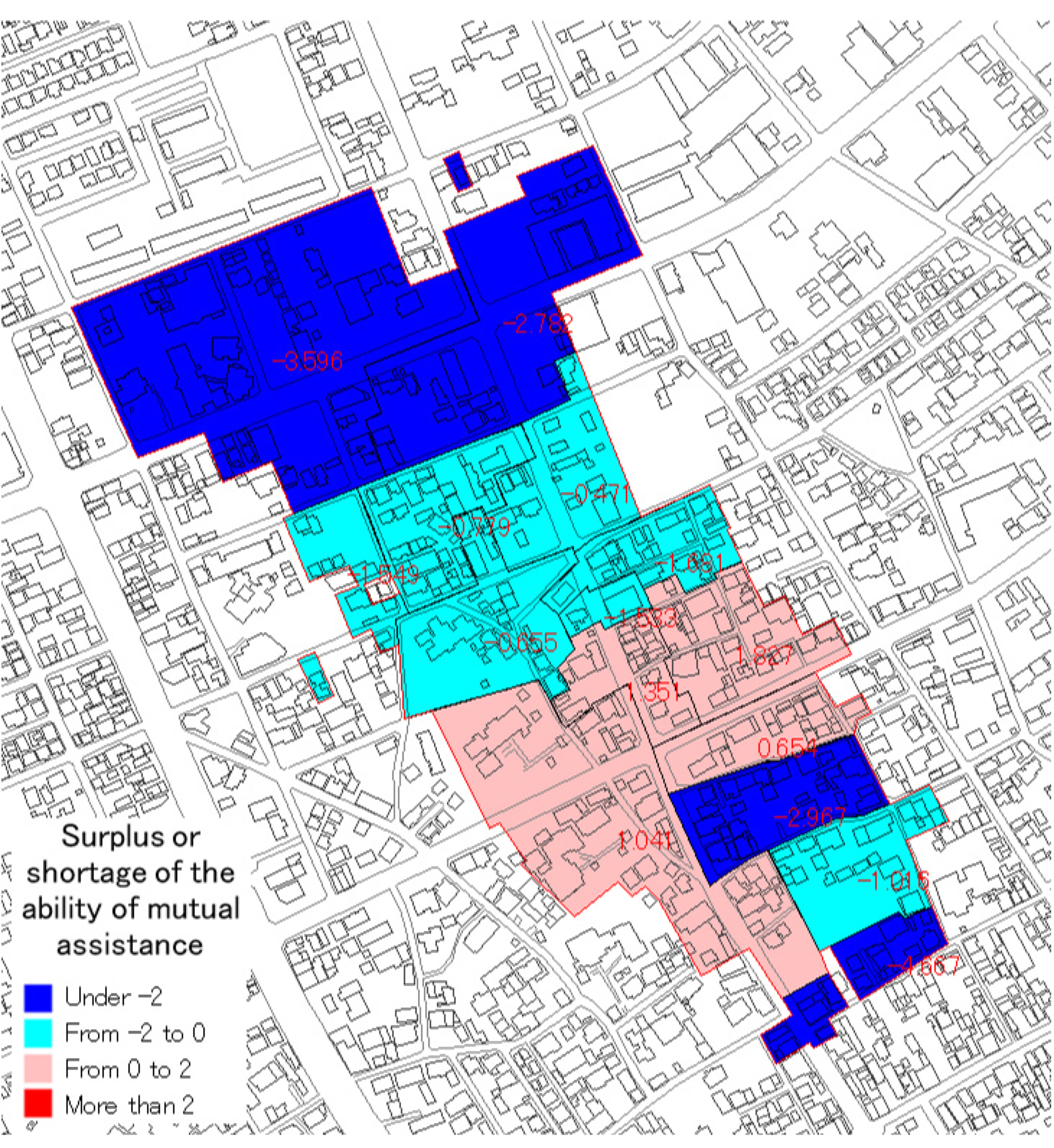
| (4): Surplus or shortage by (3) – (1) | −4.6673 | −1.0161 | −2.9669 | 0.6542 | 1.8272 | −1.6806 | −1.5326 | 1.3514 | −0.4714 | −2.7819 | −3.5959 | −1.549 | −0.7786 | −0.6553 | 1.0414 | −16.821 |
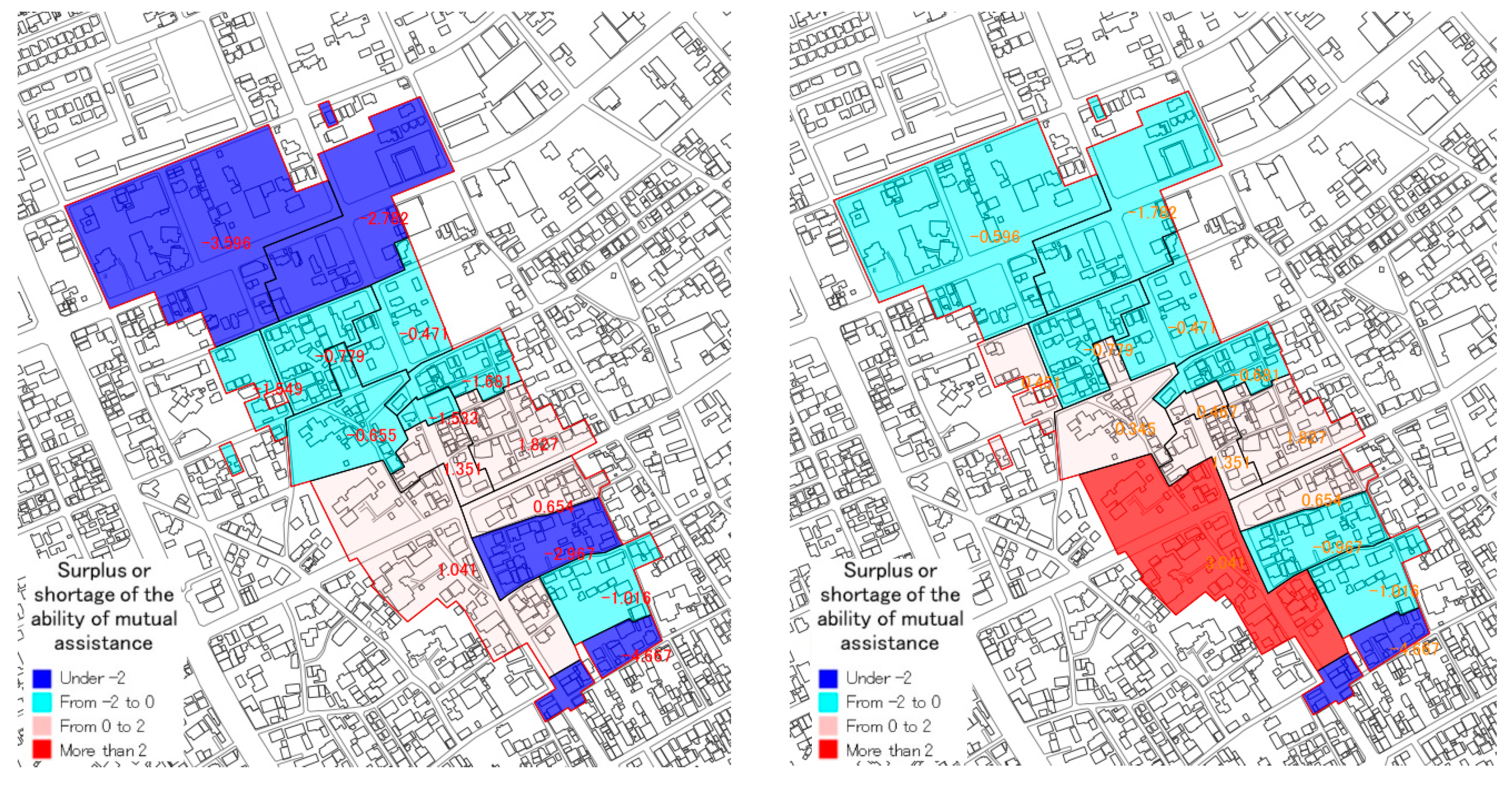
| (5): Surplus or shortage by (3) – (2) | −4.6673 | −1.0161 | −0.9669 | 0.6542 | 1.8272 | −0.6806 | 0.4674 | 1.3514 | −0.4714 | −1.7819 | −0.5959 | 0.451 | −0.7786 | 0.3447 | 3.0414 | −2.8214 |
| Date | Items |
|---|---|
| First survey 20 January, 2018 | For grasping the effect of the tools to promote the awareness of mutual assistance. Participants: 17 members |
| Second survey 20 March, 2019 | For grasping the effect of the mutual assistance map to promote detailed planning. Participants: 14 members |
| Q | Question Items | 1 | 2 | 3 | 4 | Total | |
|---|---|---|---|---|---|---|---|
| 1st | 1 | Do you think it is easy to understand mutual assistance capability by using the mutual assistance map? | 6 (35%) | 11 (65%) | 0 (0%) | 0 (0%) | 17 |
| 2 | Do you think it is easy to understand the area with high or low human damage by using the evacuation simulator? | 3 (18%) | 14 (82%) | 0 (0%) | 0 (0%) | 17 | |
| 3 | Do you think that the two tools are useful in promoting the exploration of the contents of mutual assistance activities? | 4 (24%) | 13 (76%) | 0 (0%) | 0 (0%) | 17 | |
| 4 | Do you think that the two tools are useful for enhancing the awareness of the necessity of mutual assistance activities? | 6 (35%) | 11 (65%) | 0 (0%) | 0 (0%) | 17 | |
| 5 | Free description | - | - | - | - | - | |
| - | - | - | - | - | ||
| 2nd | 1 | Do you think that understanding the person who needs someone’s support is useful for enhancing mutual assistance capability? | 6 (43%) | 8 (57%) | 0 (0%) | 0 (0%) | 14 |
| 2 | Do you think that the exploration of support contents for the person who needs someone’s support is useful for enhancing mutual assistance capability? | 5 (36%) | 7 (50%) | 2 (14%) | 0 (0%) | 14 | |
| 3 | Do you think that the mutual assistance map is useful for grasping mutual assistance capability? | 5 (36%) | 7 (50%) | 2 (14%) | 0 (0%) | 14 | |
| 4 | Do you think that the mutual assistance map is useful for the exploration of support contents for the person who needs someone’s support? | 4 (29%) | 8 (57%) | 2 (14%) | 0 (0%) | 14 | |
| 5 | Do you think that the exploration method of the district disaster mitigation plan is useful for promoting mutual assistance capability? | 3 (22%) | 9 (64%) | 2 (14%) | 0 (0%) | 14 |
Publisher’s Note: MDPI stays neutral with regard to jurisdictional claims in published maps and institutional affiliations. |
© 2021 by the authors. Licensee MDPI, Basel, Switzerland. This article is an open access article distributed under the terms and conditions of the Creative Commons Attribution (CC BY) license (https://creativecommons.org/licenses/by/4.0/).
Share and Cite
Karashima, K.; Ohgai, A. A Methodology of Workshops to Explore Mutual Assistance Activities for Earthquake Disaster Mitigation. Int. J. Environ. Res. Public Health 2021, 18, 3814. https://doi.org/10.3390/ijerph18073814
Karashima K, Ohgai A. A Methodology of Workshops to Explore Mutual Assistance Activities for Earthquake Disaster Mitigation. International Journal of Environmental Research and Public Health. 2021; 18(7):3814. https://doi.org/10.3390/ijerph18073814
Chicago/Turabian StyleKarashima, Kazuki, and Akira Ohgai. 2021. "A Methodology of Workshops to Explore Mutual Assistance Activities for Earthquake Disaster Mitigation" International Journal of Environmental Research and Public Health 18, no. 7: 3814. https://doi.org/10.3390/ijerph18073814
APA StyleKarashima, K., & Ohgai, A. (2021). A Methodology of Workshops to Explore Mutual Assistance Activities for Earthquake Disaster Mitigation. International Journal of Environmental Research and Public Health, 18(7), 3814. https://doi.org/10.3390/ijerph18073814