Estimating the Spatial Distribution of Soil Properties Using Environmental Variables at a Catchment Scale in the Loess Hilly Area, China

Abstract
1. Introduction
2. Materials and Methods
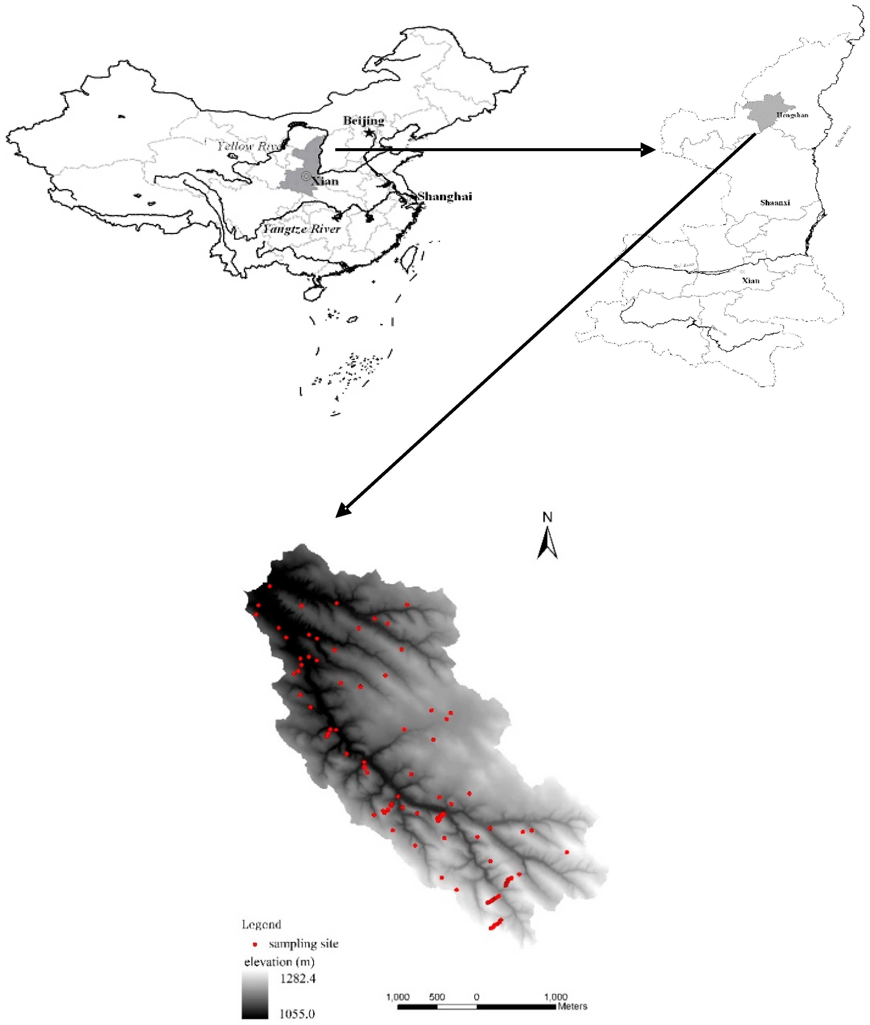
2.1. Study Area
2.2. Current Land Use Mapping
2.3. Soil Sampling and Measurements
2.4. Topographic Attributes
2.5. Statistical Analysis
3. Results and Discussion
3.1. Descriptive Statistics of Soil Properties
3.2. Effects of Land Use on Soil Properties
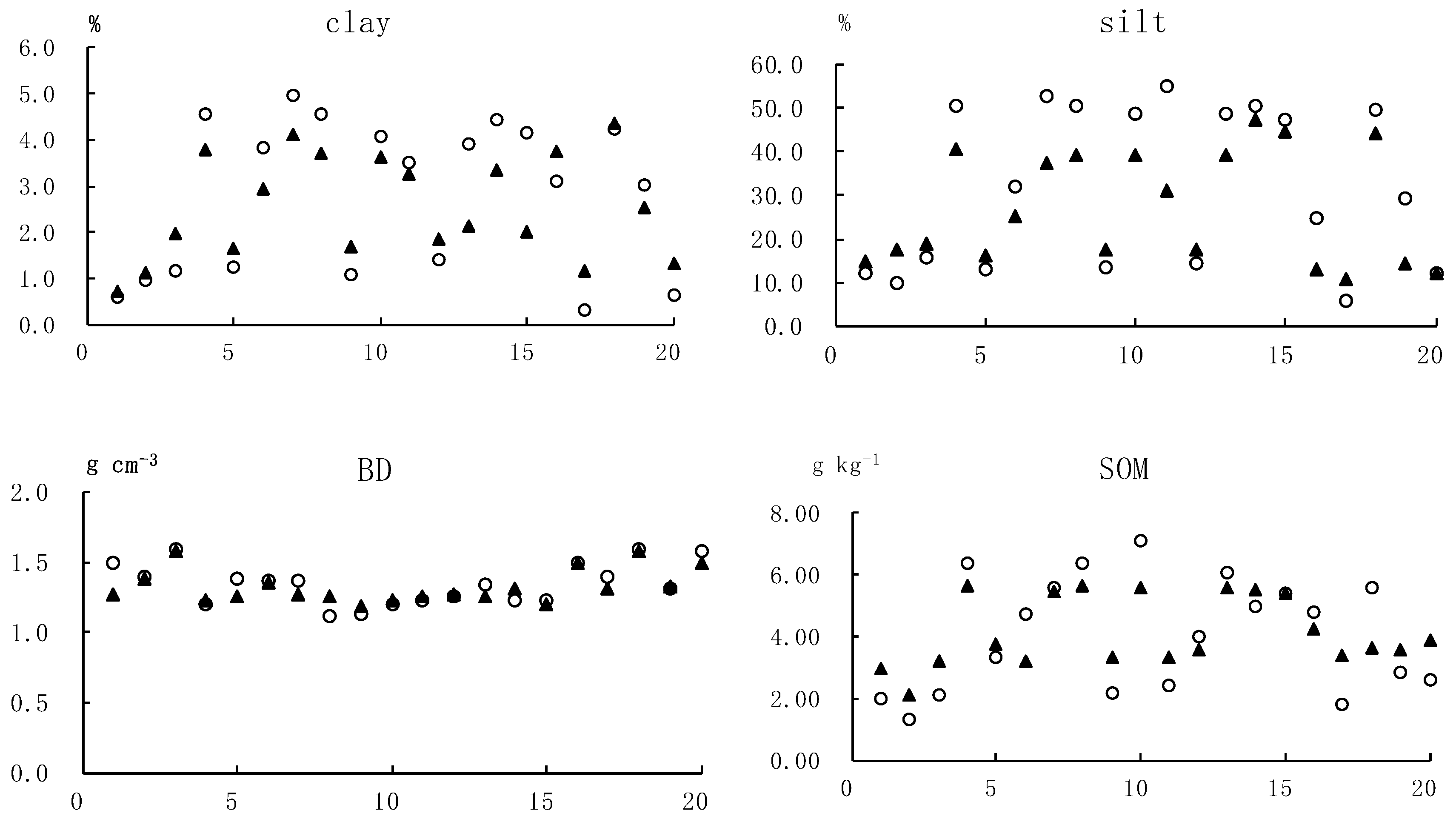
3.3. Soil Properties Associated with Landscape Position
3.4. Relationship between Soil Properties and Terrain Attributes and Key Environmental Variables in Impacting Spatial Distribution of Soil Properties
4. Conclusions
Author Contributions
Funding
Acknowledgments
Conflicts of Interest
References
- Jiang, Y.F.; Sun, K.; Guo, X.; Ye, Y.C.; Rao, L.; Li, W.F. Prediction of Spatial Distribution of Soil Properties Based on Environmental Factors and Neighbor Information. Res. Environ. Sci. 2017, 30, 1059–1068. [Google Scholar]
- Lian, G.; Guo, X.D.; Fu, B.J.; Hu, C. Prediction of the spatial distribution of soil properties based on environmental correlation and geostatistics. Trans. Chin. Soc. Agric. Eng. 2009, 25, 134–135. [Google Scholar]
- Moore, I.D.; Gessler, P.E.; Nielsen, G.A. Soil attribute prediction using terrain analysis. Soil Sci. Soc. Am. J. 1993, 57, 443–452. [Google Scholar] [CrossRef]
- Burrough, P.A. Soil variability: A late 20th century view. Soils Fertil. 1993, 56, 529–562. [Google Scholar]
- Park, S.J.; Vlek, P.L.G. Environmental correlation of three-dimensional soil spatial variability: A comparison of three adaptive techniques. Geoderma 2002, 109, 117–140. [Google Scholar] [CrossRef]
- Benning, T.L.; Seastedt, T.R. Landscape-level interactions between topoedaphic features and nitrogen limitation in tallgrass prairie. Landsc. Ecol. 1995, 10, 337–348. [Google Scholar] [CrossRef]
- Schimel, D.S.; Kittel, T.G.F.; Knapp, A.K. Physiological interactions along resource gradients in tallgrass prairie. Ecology 1991, 72, 672–684. [Google Scholar] [CrossRef]
- Townsend, A.R.; Vitousek, P.M.; Trumbore, S.E. Soil organic matter dynamics along gradients in temperature and land use on the island of Hawaii. Ecology 1995, 76, 721–733. [Google Scholar] [CrossRef]
- Kosmas, C.; Gerontidis, S.; Marathianou, M. The effect of land use change on soils and vegetation over various lithological formations on Lesvos (Greece). Catena 2000, 40, 51–68. [Google Scholar] [CrossRef]
- Kosmas, C.; Danalatos, N.; Moustakas, N. The impacts of parent material and landscape position on drought and biomass production of wheat under semi-arid conditions. Soil Technol. 1993, 6, 337–349. [Google Scholar] [CrossRef]
- Bertin, T.; Martín, J.A.R.; John, C.W.; Keith, S.; Andrew, S.; Jerome, T. Landscape approach to assess key soil functional properties in the highlands of Cameroon: Repercussions of spatial relationships for land management interventions. J. Geochem. Explor. 2017, 178, 35–44. [Google Scholar]
- Young, W.J.; Marston, F.M.; Davis, J.R. Nutrient exports and land use in Australian catchments. J. Environ. Manag. 1996, 47, 165–183. [Google Scholar] [CrossRef]
- Wang, J.; Fu, B.J.; Qiu, Y. Soil nutrients in relation to land use and landscape position in the semi-arid small catchment on the loess plateau in China. J. Arid Environ. 2001, 48, 537–550. [Google Scholar] [CrossRef]
- Fu, B.J.; Ma, K.M.; Zhou, H.F. The effect of land use structure on the distribution of soil nutrients in the hilly area of the loess plateau, China. Chin. Sci. Bull. 1999, 44, 732–736. [Google Scholar] [CrossRef]
- Hontoria, C.R.D.J.; Saa, A. Relationships between soil organic carbon and site characteristics in Peninsular Spain. Soil Sci. Soc. Am. J. 1999, 63, 614–621. [Google Scholar] [CrossRef]
- Iqbal, J.; Thomasson, J.A.; Jenkins, J.N.; Owens, P.R.; Whisler, F.D. Spatial variability analysis of soil physical properties of alluvial soils. Soil Sci. Soc. Am. J. 2005, 69, 1338–1350. [Google Scholar] [CrossRef]
- Nanos, N.; Martín, J.A.R. Multiscale analysis of heavy metal contents in soils: Spatial variability in the Duero river basin (Spain). Geoderma 2012, 189–190, 554–562. [Google Scholar] [CrossRef]
- Lizarraga, H.S.; Lai, C.G. Effects of spatial variability of soil properties on the seismic response of an embankment dam. Soil Dyn. Earthq. Eng. 2014, 64, 113–128. [Google Scholar] [CrossRef]
- Fu, B.J.; Chen, L.D.; Ma, K.M. The relationships between land use and soil conditions in the hilly area of the loess plateau in northern Shaanxi, China. Catena 2000, 39, 69–78. [Google Scholar] [CrossRef]
- Thomas, M.L.; Lal, R.; Logan, T. Land use and management effects on nonpoint loading from Miamian soil. Soil Sci. Soc. Am. J. 1992, 56, 1871–1875. [Google Scholar] [CrossRef]
- Batjes, N.H. Total carbon and nitrogen in the soils of the world. Eur. J. Soil Sci. 2014, 65, 10–21. [Google Scholar] [CrossRef]
- Martin, M.P.; Orton, T.G.; Lacarce, E.; Meersmans, J.; Saby, N.P.A.; Paroissien, J.B.; Jolivet, C.; Boulonne, L.; Arrouays, D. Evaluation of modelling approaches for predicting the spatial distribution of soil organic carbon stocks at the national scale. Geoderma 2014, 223–225, 97–107. [Google Scholar] [CrossRef]
- Kalivas, D.P.; Triantakonstantis, D.P.; Kollias, V.J. Spatial prediction of two soil properties using topographic information. Glob. Nest 2002, 14, 41–49. [Google Scholar]
- Florinsky, I.V.; Eilers, R.G.; Manning, G.R. Prediction of soil properties by digital terrain modeling. Environ. Model. Softw. 2002, 17, 295–311. [Google Scholar] [CrossRef]
- Chen, L.D.; Wang, J.; Fu, B.J.; Qiu, Y. Land use change in a small catchment of northern Loess Plateau, China. Agric. Ecosyst. Environ. 2001, 86, 163–172. [Google Scholar] [CrossRef]
- Zhao, G.; Mu, X.; Wen, Z.; Wang, F.; Gao, P. Soil erosion, conservation, and eco-environment changes in the Loess Plateau of China. Land Degrad. Dev. 2013, 24, 499–510. [Google Scholar] [CrossRef]
- Qiu, Y.; Fu, B.J.; Wang, J. Soil moisture variation in relation to topography and land use in a hillslope catchment of the Loess Plateau, China. J. Hydrol. 2001, 240, 243–263. [Google Scholar] [CrossRef]
- Guo, S.L.; Liu, W.Z.; Shi, Z.Y. Soil nutrients distribution and its relation to landform and vegetation at small watershed in semiarid area. Agric. Res. Arid Areas 2003, 21, 40–43. [Google Scholar]
- Jia, Y.P.; Duan, J.N. Spatial distribution characteristics of the carbonate carbon content in soil in a small watershed in the gully region of the Loess Plateau. Arid Land Geogr. 2004, 27, 166–170. [Google Scholar]
- Wang, J.L.; Lü, Y.H.; Zeng, Y.; Zhao, Z.J.; Zhang, L.W.; Fu, B.J. Spatial heterogeneous response of land use and landscape functions to ecological restoration: The case of the Chinese loess hilly region. Environ. Earth Sci. 2014, 72, 2683–2696. [Google Scholar] [CrossRef]
- Odumo, B.; Carbonell, G.; Angeyo, H.; Patel, J.; Torrijos, M.; Martín, J.R. Impact of gold mining associated with mercury contamination in soil, biota sediments and tailings in Kenya. Environ. Sci. Pollut. Res. 2014, 21, 12426–12435. [Google Scholar] [CrossRef] [PubMed]
- Martín, J.A.R.; Gutiérrez, C.; Escuer, M.; González, M.T.G.; Herrera, R.C.; Águila, N. Effect of mine tailing on the spatial variability of soil nematodes from lead pollution in La Union (Spain). Sci. Total Environ. 2014, 473–474, 518–529. [Google Scholar] [CrossRef] [PubMed]
- Stutter, M.I.; Lumsdon, D.G.; Billett, M.F.; Low, D.; Deeks, L.K. Spatial variability in properties affecting organic horizon carbon storage in upland soils. Soil Sci. Soc. Am. J. 2009, 73, 1724–1732. [Google Scholar] [CrossRef]
- Glendell, M.; Granger, S.J.; Bol, R.; Brazier, R.E. Quantifying the spatial variability of soil physical and chemical properties in relation to mitigation of diffuse water pollution. Geoderma 2014, 214–215, 25–41. [Google Scholar] [CrossRef]
- Martín, J.A.R.; Álvaro-Fuentes, J.; Gonzalo, J.; Gil, C.; Miras, J.J.R.; Corbí, J.M.G.; Boluda, R. Assessment of the soil organic carbon stock in Spain. Geoderma 2016, 264 Pt A, 117–125. [Google Scholar]
- McKenzie, N.J.; Austin, M.P. A quantitative Australian approach to medium and small scale surveys based on soil stratigraphy and environmental correlation. Geoderma 1993, 57, 329–355. [Google Scholar] [CrossRef]
- McKenzie, N.J.; Ryan, P.J. Spatial prediction of soil properties using environmental correlation. Geoderma 1999, 89, 67–94. [Google Scholar] [CrossRef]
- McBratney, A.B.; Field, D.J.; Koch, A. The dimensions of soil security. Geoderma 2014, 213, 203–210. [Google Scholar] [CrossRef]
- Kerry, R.; Oliver, M.A.; Frogbrook, Z.L. Sampling precision agriculture. In Geostatistical Applications for Precision Agriculture; Springer: Cham, The Netherlands, 2010; pp. 35–63. [Google Scholar]
- Forkuor, G.; Hounkpatin, O.K.L.; Welp, G.; Thiel, M. High Resolution Mapping of Soil Properties Using Remote Sensing Variables in South-Western Burkina Faso: A Comparison of Machine Learning and Multiple Linear Regression Models. PLoS ONE 2017, 12, e0170478. [Google Scholar] [CrossRef]
- Brubaker, S.C.; Jones, A.J.; Lewis, D.T.; Frank, K. Soil properties associated with landscape positions. Soil Sci. Soc. Am. J. 1993, 57, 235–239. [Google Scholar] [CrossRef]
- Liu, G.S.; Jiang, N.H.; Zhang, L.D. Soil Physical and Chemical Analysis and Description of Soil Profiles; Standard Press of China: Beijing, China, 1996; pp. 48–56. [Google Scholar]
- Bourennane, H.; King, D.; Chery, P. Improving the kriging of a soil variables using slope gradient as external drift. Eur. J. Soil Sci. 1996, 47, 473–483. [Google Scholar] [CrossRef]
- King, D.; Bourennane, H.; Isambert, M. Relationships of the presence of a non-calcareous clay-loam horizon to DEM attributes in a gently sloping area. Geoderma 1999, 89, 95–111. [Google Scholar] [CrossRef]
- Hengl, T.; Heuvelink, G.B.M.; Stein, A. A generic framework for spatial prediction of soil variables based on regression-kriging. Geoderma 2004, 120, 75–93. [Google Scholar] [CrossRef]
- Tang, K. Characteristics and perspectives on scientific discipline of soil erosion and soil and water conservation in China. Res. Soil Water Conserv. 1999, 6, 2–7. [Google Scholar]
- Zheng, J.; Wu, R.; Zhai, L. Distribution of soil fertility in Zhifang gully watershed of the loess hilly region. Bull. Soil Water Conserv. 1996, 16, 26–30. [Google Scholar]
- Lian, G.; Guo, X.D.; Fu, B.J. Farmer’s perception and response towards grain-for-green program and eco-environment based on participatory rural appraisal. Acta Ecol. Sin. 2005, 25, 1741–1747. [Google Scholar]
- Chen, H.; Zhang, S. Nitrogen and phosphorus movement from loess tillage under modeling the rainfall-runoff erosion process. Sci. Geogr. Sin. 1991, 11, 142–148. [Google Scholar]
- Fu, B.J.; Chen, L.D. Agricultural landscape spatial analysis in the semi-arid hill area of the Loess Plateau, China. J. Arid Environ. 2000, 44, 291–303. [Google Scholar] [CrossRef]
- Wang, J.; Fu, B.J.; Qiu, Y. The effects of land use and its patterns on soil properties in a small catchment of the Loess Plateau. J. Environ. Sci. 2003, 15, 263–266. [Google Scholar]
- Malo, D.D.; Worcester, B.K.; Cassel, D.K. Soil-landscape relationships in a closed drainage system. Soil Sci. Soc. Am. J. 1974, 38, 813–818. [Google Scholar] [CrossRef]
- Lowery, B.; Swan, J.; Schumacher, T. Physical properties of selected soil by erosion class. J. Soil Water Conserv. 1995, 50, 306–311. [Google Scholar]
- Verchot, L.V.; Franklin, E.C.; Gilliam, J.W. Nitrogen cycling in piedmont vegetated filter zones: Surface soil processes. J. Environ. Qual. 1997, 26, 337–347. [Google Scholar] [CrossRef]
- Miller, P.M.; Singer, M.J.; Nielsen, D.R. Spatial variability of wheat yield and soil properties on complex hills. Soil Sci. Soc. Am. J. 1988, 52, 1133–1141. [Google Scholar] [CrossRef]
- Burt, T.P.; Butcher, D.P. Topographic controls of soil moisture distribution. J. Soil Sci. 1985, 36, 469–486. [Google Scholar] [CrossRef]
- Nyberg, L. Spatial variability of soil water content in the covered catchment of Gardsjon, Sweden. Hydrol. Process. 1996, 10, 89–103. [Google Scholar] [CrossRef]


| Soil Properties 1 | Clay (%) | Silt (%) | BD (g cm−3) | SOM (g kg−1) | TN (g kg−1) | TP (g kg−1) |
|---|---|---|---|---|---|---|
| Mean | 3.50 | 40.16 | 1.26 | 4.47 | 0.36 | 0.85 |
| Median | 3.96 | 47.47 | 1.27 | 4.63 | 0.36 | 0.78 |
| Minimum | 0.25 | 3.79 | 1.12 | 1.30 | 0.11 | 0.37 |
| Maximum | 10.70 | 76.26 | 1.42 | 9.24 | 0.87 | 1.50 |
| Range | 10.46 | 72.48 | 0.31 | 7.94 | 0.76 | 1.13 |
| Standard deviation | 1.71 | 16.34 | 0.08 | 1.69 | −0.13 | 0.26 |
| Coefficient of variation (%) | 48.90 | 40.69 | 6.33 | 37.86 | 37.26 | 30 |
| One-Sample K-S Test | 1.49 | 1.86 | 0.62 | 0.66 | 0.49 | 1.24 |
| Soil Properties 1 | clay | silt | BD | SOM | TN | TP |
|---|---|---|---|---|---|---|
| clay | ||||||
| silt | 0.92 ** | |||||
| BD | −0.60 ** | −0.70 ** | ||||
| SOM | 0.58 ** | 0.58 ** | −0.31 ** | |||
| TN | 0.75 ** | 0.63 ** | −0.38 ** | 0.86 ** | ||
| TP | 0.14 | 0.17 | −0.19 | 0.20 | 0.09 |
| Land Use 2 | Soil Properties 1 | |||||
|---|---|---|---|---|---|---|
| Clay (%) | Silt (%) | BD (g cm−3) | SOM (g kg−1) | TN (g kg−1) | TP (g kg−1) | |
| SFL | 3.32 ac | 39.50 ac | 1.23 a | 4.17 ab | 0.33 a | 0.77 a |
| TFL | 3.24 bc | 39.47 bc | 1.29 a | 4.97 abc | 0.35 ab | 1.30 b |
| CDL | 9.56 d | 67.81 d | 1.27 a | 7.53 c | 0.81 c | 0.88 ab |
| WL | 2.46 ab | 30.01 ab | 1.26 a | 3.77 b | 0.31 a | 0.88 a |
| SL | 1.22 b | 15.72 b | 1.30 a | 1.55 d | 0.13 d | 0.61 a |
| GL | 3.79 c | 43.97 c | 1.29 a | 4.88 a | 0.39 b | 0.87 a |
| F value | 12.61 *** | 4.66 *** | 2.22 | 5.23 *** | 12.10 *** | 3.37 ** |
| Landscape Position 3 | Soil Properties 1 | |||||
|---|---|---|---|---|---|---|
| clay (%) | silt (%) | BD (g cm−3) | SOM (g kg−1) | TN (g kg−1) | TP (g kg−1) | |
| CT | 3.00 a | 34.64 | 1.34 a | 4.59 ab | 0.36 ab | 0.08 |
| US | 3.70 ab | 43.76 | 1.24 b | 4.57 ab | 0.37 ab | 0.90 |
| MS | 3.85 ab | 44.15 | 1.22 b | 4.72 ab | 0.38 ab | 0.81 |
| LS | 3.14 a | 37.93 | 1.25 b | 3.82 a | 0.31 a | −0.85 |
| FV | 5.31 b | 46.19 | 1.27 ab | 5.64 b | 0.49 b | 0.88 |
| F value | 1.89 * | 0.93 | 1.42 * | 1.31 * | 1.82 * | 2.86 |
| Soil Properties 1 | H | β | cosα | sinα | Kv | Kh | CTI | SPI | STI |
|---|---|---|---|---|---|---|---|---|---|
| clay | −0.17 | 0.28 * | 0.24 * | −0.01 | −0.11 | 0.27 * | −0.42 ** | −0.09 | −0.15 |
| silt | −0.07 | 0.32 ** | 0.21 | −0.09 | −0.07 | 0.32 ** | −0.52 ** | −0.15 | −0.20 |
| BD | 0.13 | −0.34 ** | −0.12 | 0.10 | −0.01 | −0.10 | 0.43 ** | −0.09 | −0.02 |
| SOM | 0.03 | −0.10 | 0.07 | 0.04 | −0.12 | 0.12 | −0.23 * | −0.31 ** | −0.29 ** |
| TN | −0.10 | −0.02 | 0.20 | 0.11 | −0.09 | 0.11 | −0.22 | −0.21 | −0.23 * |
| TP | 0.09 | −0.17 * | −0.10 | 0.06 | 0.12 | −0.12 | 0.06 | 0.15 | 0.05 |
| Dependent Variables | clay | silt | BD 1 | SOM | TN | TP |
|---|---|---|---|---|---|---|
| Constant | 5.87 | 74.65 | 1.15 | 0.71 | 0.05 | 830.70 |
| Independent variables | ||||||
| H | ||||||
| β | ||||||
| cosα | 0.41 (5) 4 | |||||
| sinα | −0.59 (4) | −4.81 (4) | ||||
| Kv | −0.01 (2) | |||||
| Kh | ||||||
| CTI | −0.49 (2) | −6.39 (1) | 0.02 (1) | |||
| SPI | −0.04 (3) | −0.002 (3) | ||||
| STI | ||||||
| SFL 2 | ||||||
| TFL | 469.44 (1) | |||||
| CDL | 7.10 (1) | 37.99 (2) | 0.39 (2) | 0.05 (1) | ||
| WL | ||||||
| SL | −0.22 (1) | −0.02 (2) | ||||
| GL | 0.92 (3) | 9.26 (3) | 0.08 (4) | 0.006 (4) | ||
| Model | ||||||
| Sum of squares | 139.94 | 9137.78 | 0.11 | 0.75 | 0.007 | 635,358.1 |
| Df | 5 | 4 | 2 | 4 | 4 | 1 |
| Mean square | 27.99 | 2284.45 | 0.06 | 0.19 | 0.002 | 635,358.1 |
| F-ratio | 23.82 | 14.74 | 14.03 | 9.42 | 18.91 | 11.05 |
| p-Value | 0.000 | 0.000 | 0.000 | 0.000 | 0.000 | 0.001 |
| Residual | ||||||
| Sum of squares | 83.42 | 11,156.65 | 0.17 | 1.43 | 0.007 | 4,314,257 |
| Df | 85 | 86 | 88 | 86 | 86 | 89 |
| Mean square | 1.18 | 154.95 | 0.004 | 0.02 | 2 | 57,523.42 |
| R2 | 0.63 | 0.45 | 0.40 | 0.34 | 0.51 | 0.13 |
| Standard error | 1.08 | 12.45 | 0.06 | 0.14 | 0.009 | 239.84 |
| Validation | ||||||
| MPE | −0.15 | 0.58 | 0.009 | −0.04 | −0.008 | −343.18 |
| RMSPE | 1.97 | 2.32 | 0.13 | 0.17 | 0.02 | 354.54 |
© 2019 by the authors. Licensee MDPI, Basel, Switzerland. This article is an open access article distributed under the terms and conditions of the Creative Commons Attribution (CC BY) license (http://creativecommons.org/licenses/by/4.0/).
Share and Cite
Hu, C.; Wright, A.L.; Lian, G. Estimating the Spatial Distribution of Soil Properties Using Environmental Variables at a Catchment Scale in the Loess Hilly Area, China. Int. J. Environ. Res. Public Health 2019, 16, 491. https://doi.org/10.3390/ijerph16030491
Hu C, Wright AL, Lian G. Estimating the Spatial Distribution of Soil Properties Using Environmental Variables at a Catchment Scale in the Loess Hilly Area, China. International Journal of Environmental Research and Public Health. 2019; 16(3):491. https://doi.org/10.3390/ijerph16030491
Chicago/Turabian StyleHu, Chenxia, Alan L Wright, and Gang Lian. 2019. "Estimating the Spatial Distribution of Soil Properties Using Environmental Variables at a Catchment Scale in the Loess Hilly Area, China" International Journal of Environmental Research and Public Health 16, no. 3: 491. https://doi.org/10.3390/ijerph16030491
APA StyleHu, C., Wright, A. L., & Lian, G. (2019). Estimating the Spatial Distribution of Soil Properties Using Environmental Variables at a Catchment Scale in the Loess Hilly Area, China. International Journal of Environmental Research and Public Health, 16(3), 491. https://doi.org/10.3390/ijerph16030491