Water Productivity Evaluation under Multi-GCM Projections of Climate Change in Oases of the Heihe River Basin, Northwest China


Abstract
1. Introduction
2. Materials and Methods
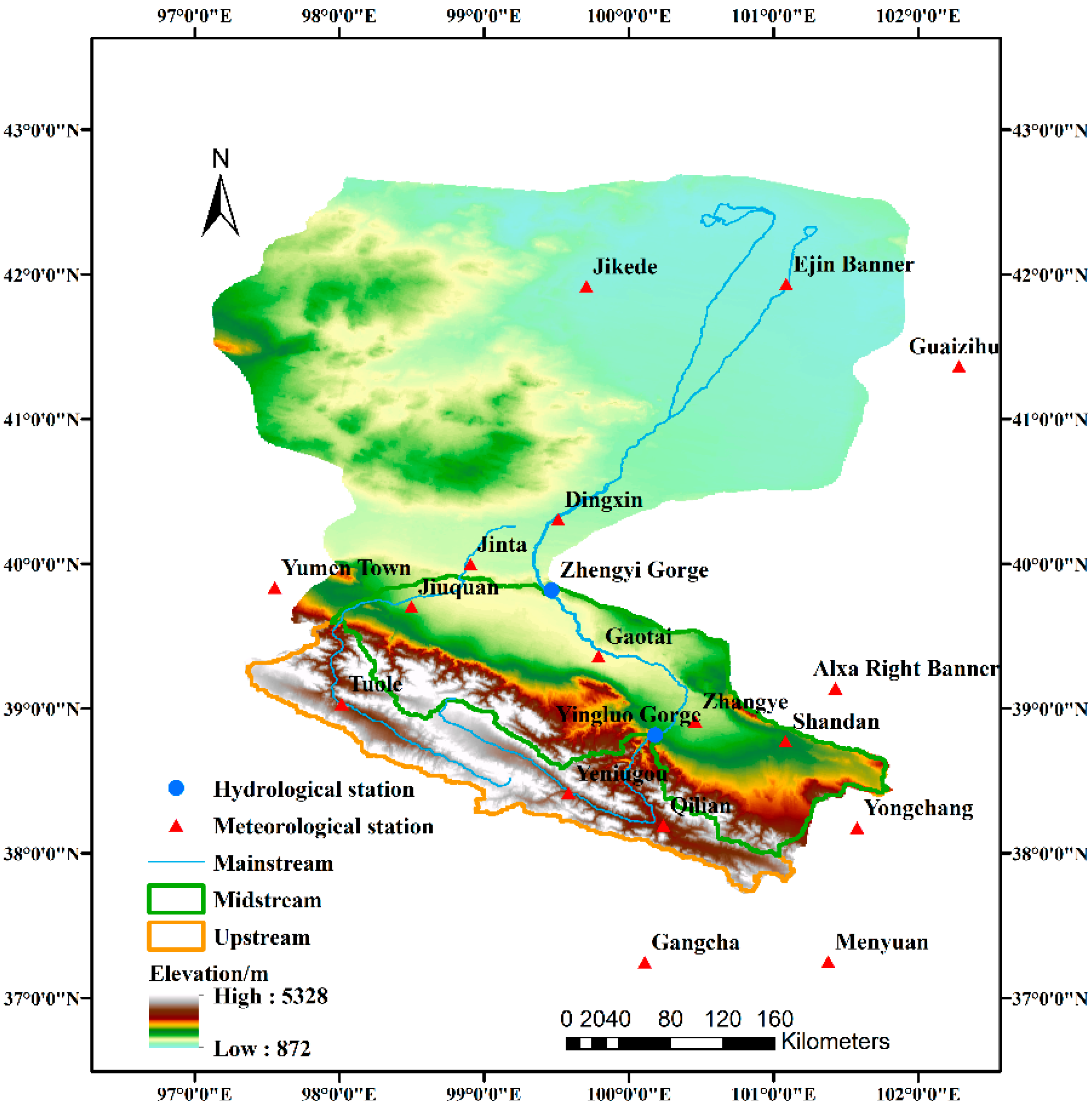
2.1. Study Region
2.2. Data
2.3. Methods
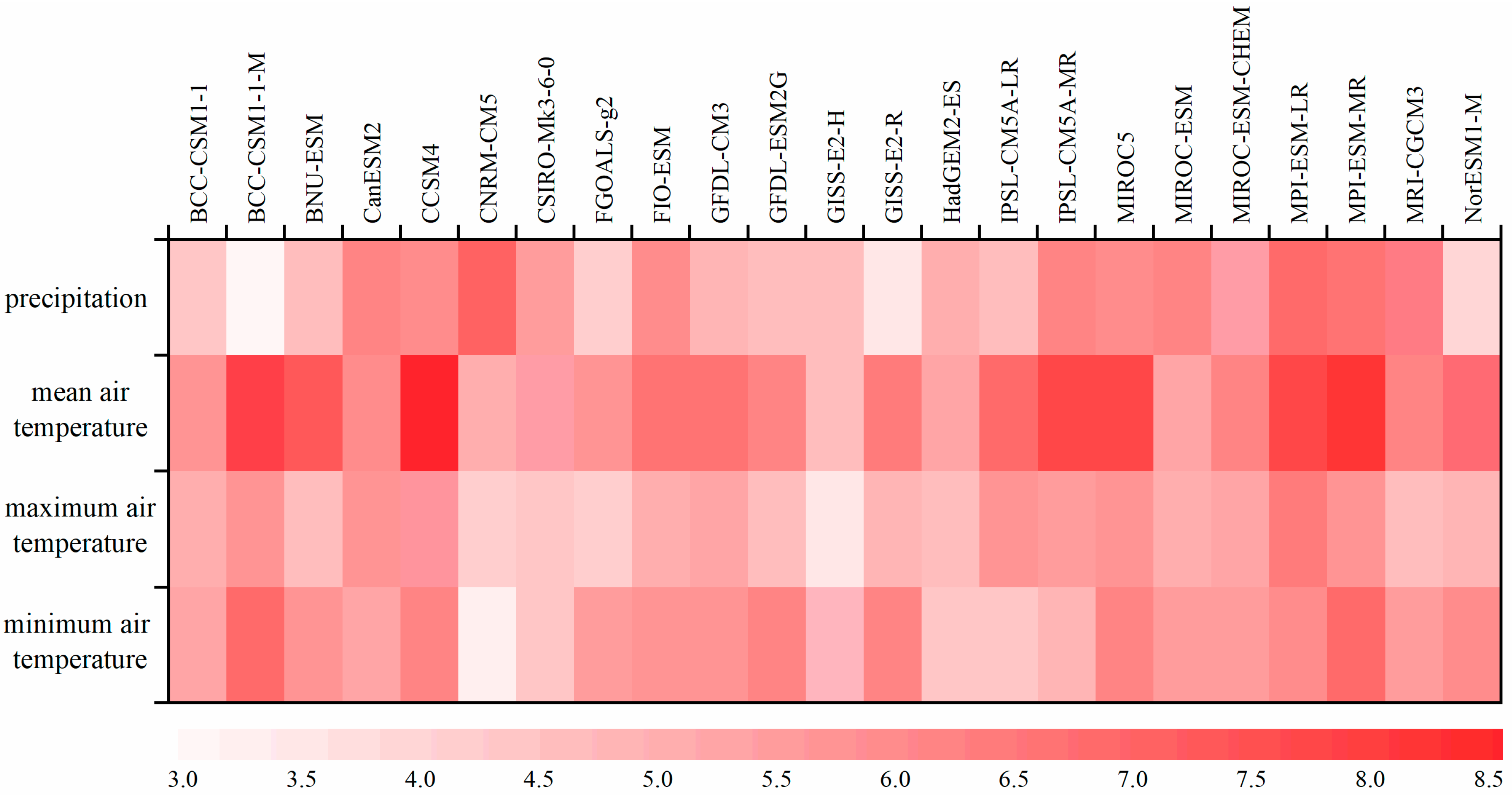
2.3.1. Multi-GCM Performance Evaluation
2.3.2. The SWAP-EPIC Model
2.3.3. Statistical Downscaling for Climate Change Scenarios
3. Results and Discussion
3.1. Multi-GCM Performance Evaluation
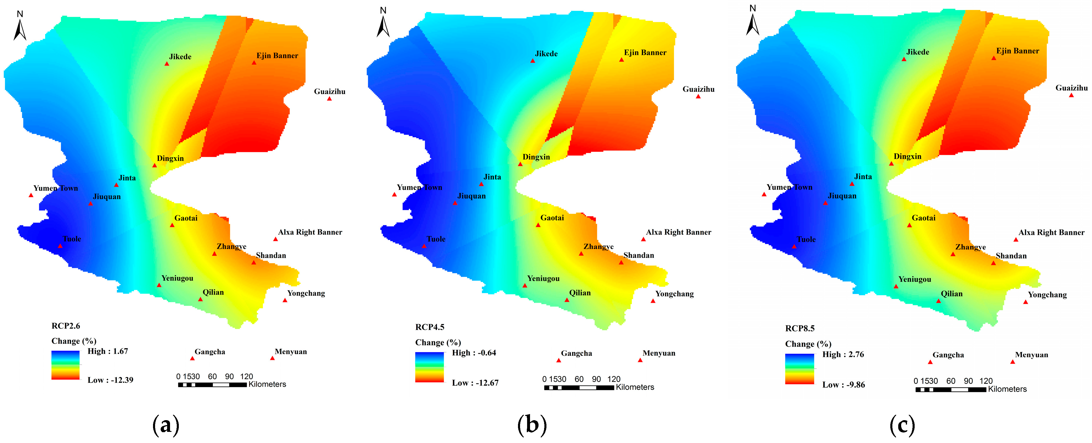
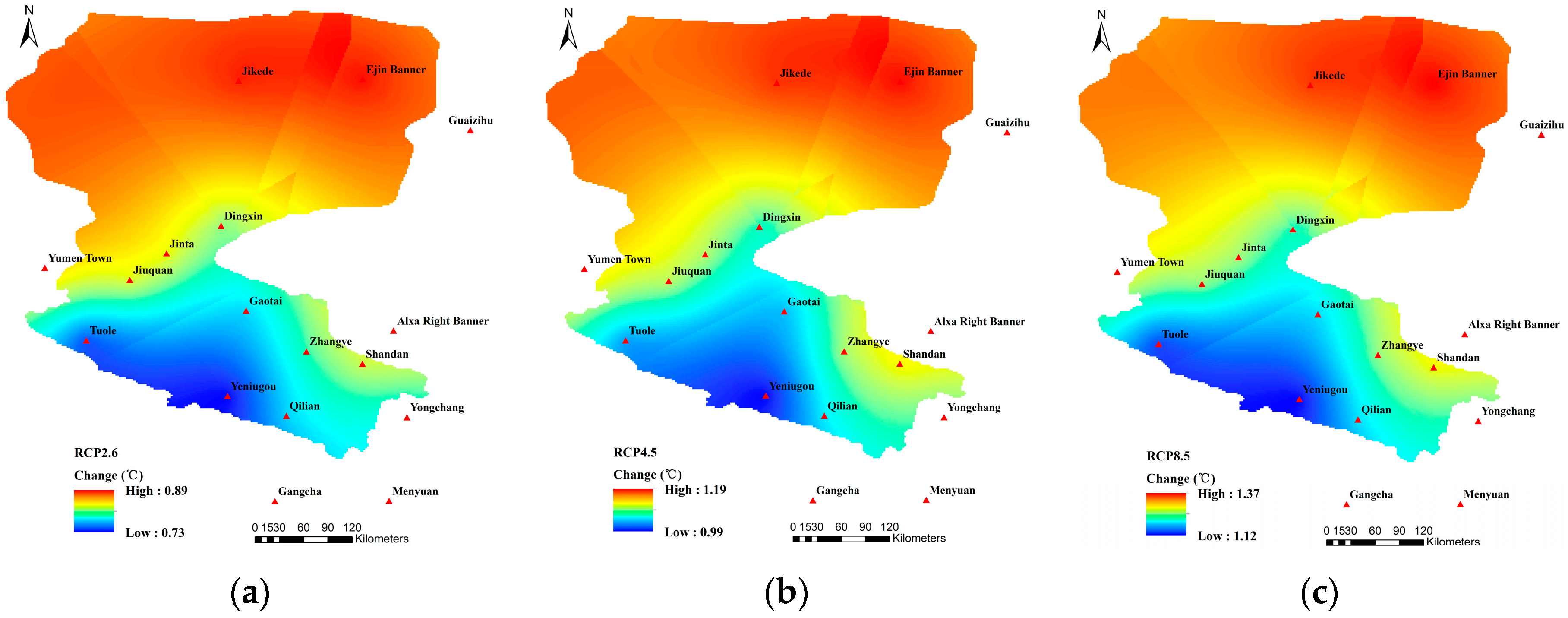
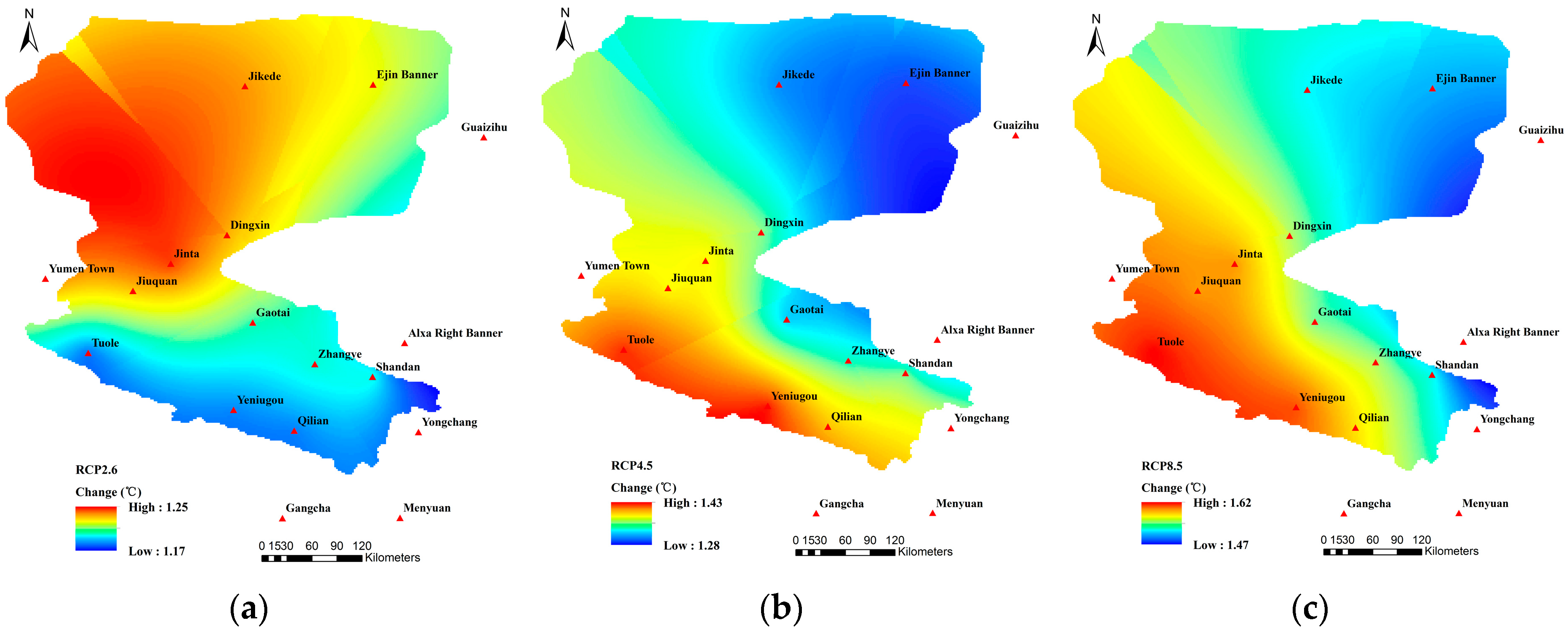
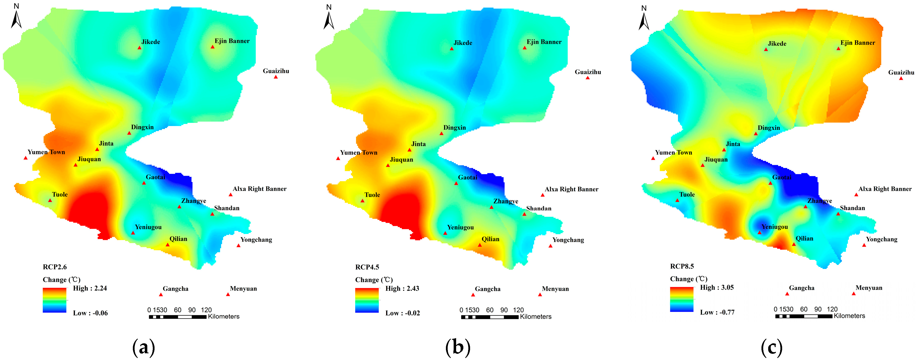
3.2. Multi-GCM Projections of Climate Change
3.3. Preparation for SWAP-EPIC
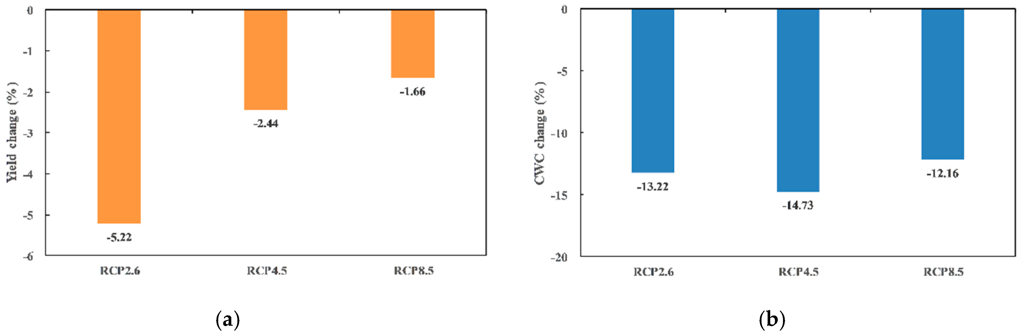
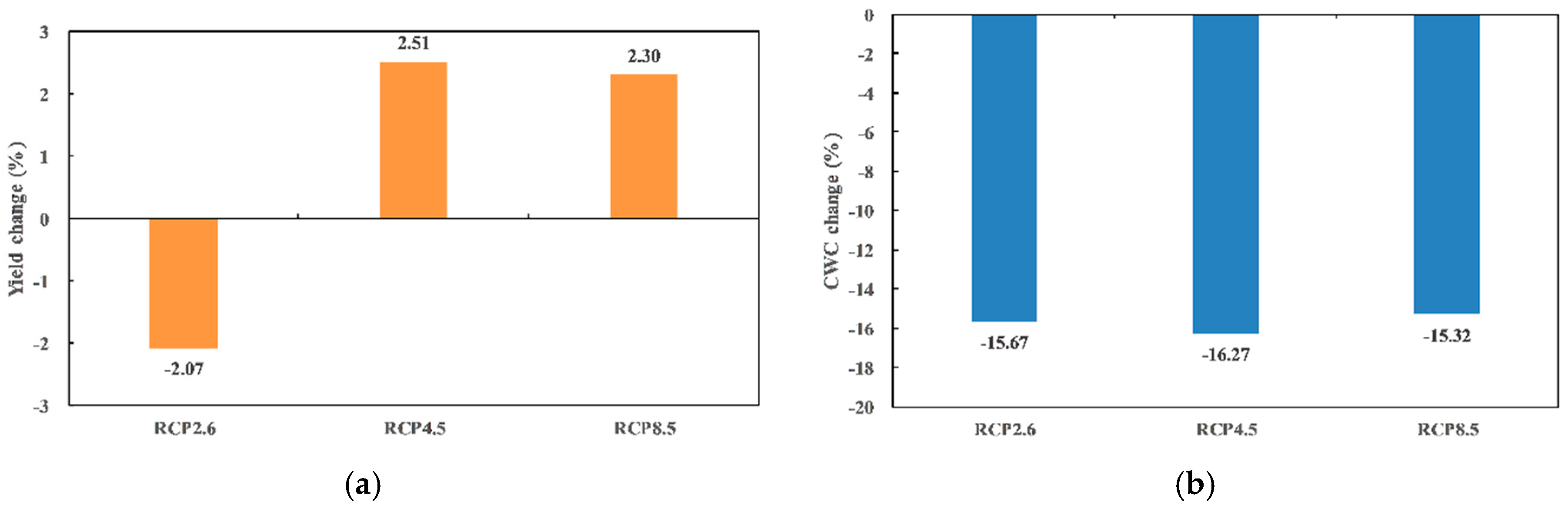
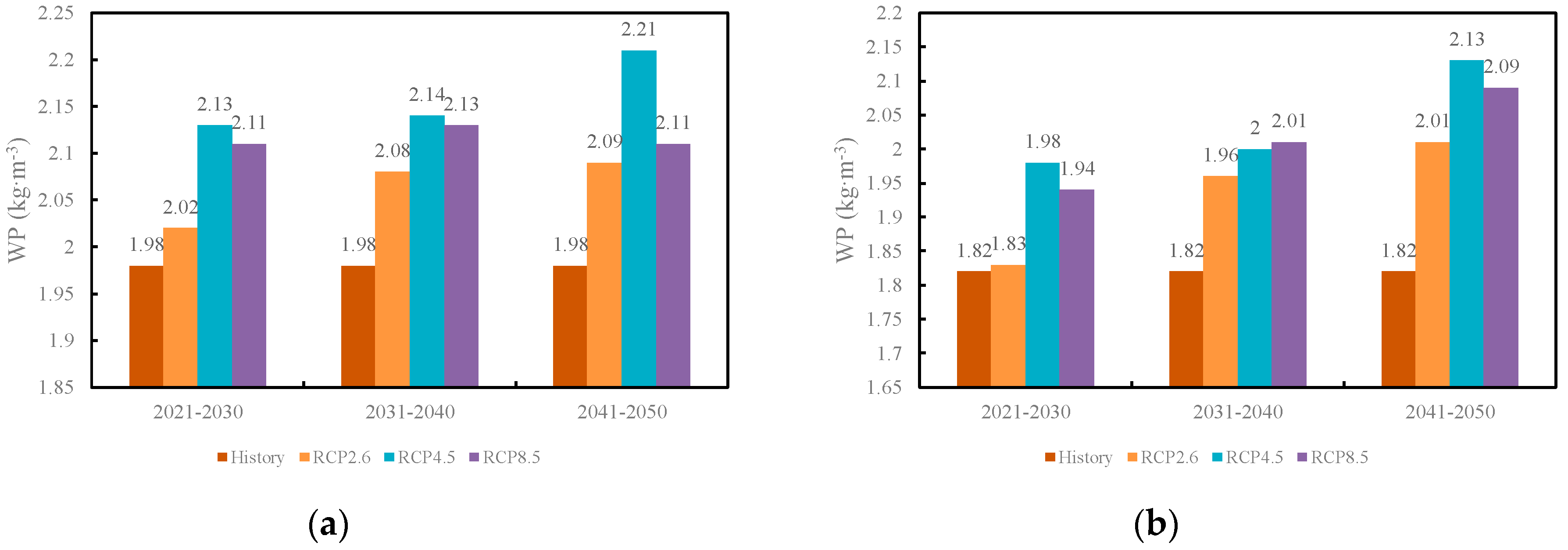
3.4. Water Productivity Evaluation
4. Conclusions
Author Contributions
Funding
Acknowledgments
Conflicts of Interest
References
- Intergovernmental Panel on Climate Change. Climate Change 2013–The Physical Science Basis: Working Group I Contribution to the Fifth Assessment Report of the Intergovernmental Panel on Climate Change; Cambridge University Press: Cambridge, UK, 2014. [Google Scholar]
- Zuo, H.C.; Lv, S.H.; Hu, Y.J. Variation trend of yearly mean air temperature and precipitation in China in the last 50 years. Plateau Meteorol. 2004, 23, 238–244. [Google Scholar]
- Wang, F. Future Hydrological Variations of RCP-Based Scenarios for the Heihe River Basin. M.S. Thesis, China Agricultural University, Beijing, China, June 2016. [Google Scholar]
- Chen, H.; Xu, C.Y.; Guo, S.L. Comparison and evaluation of multiple GCMs, statistical downscaling and hydrological models in the study of climate change impacts on runoff. J. Hydrol. 2012, 36–45, 434–435. [Google Scholar] [CrossRef]
- Hu, Y.; Maskey, S.; Uhlenbrook, S. Downscaling daily precipitation over the Yellow River source region in China: A comparison of three statistical downscaling methods. Theor. Appl. Climatol. 2013, 112, 447–460. [Google Scholar] [CrossRef]
- Wilby, R.L.; Hay, L.E.; Leavesley, G.H. A comparison of downscaled and raw GCM output: Implications for climate change scenarios in the San Juan River basin, Colorado. J. Hydrol. 1999, 225, 67–91. [Google Scholar] [CrossRef]
- Wilby, R.L.; Dawson, C.W.; Barrow, E.M. SDSM-A decision support tool for the assessment of regional climate change impacts. Environ. Model. Softw. 2002, 17, 145–157. [Google Scholar] [CrossRef]
- Wilby, R.L.; Tomlinson, O.J.; Dawson, C.W. Multisite Simulation of Precipitation by Conditional Resampling. Clim. Res. 2003, 23, 183–194. [Google Scholar] [CrossRef]
- Fan, L.J.; Fu, C.B.; Chen, D.L. Estimation of local temperature change scenarios in North China using statistical downscaling method. Chin. J. Atmos. Sci. 2007, 31, 887–897. [Google Scholar]
- Dai, H.H.; Yang, H.B.; Hu, Q.F. Prediction of climate change over Shule River basin based on a statistical downscaling method. Hydro-Sci. Eng. 2015, 5, 46–53. [Google Scholar]
- Hao, L.N.; Su, X.L.; Wang, N. Future spatial and temporal changes of temperature and precipitation in Hexi corridor based on SDSM. J. Northwest A&F Univ. 2015, 43, 219–228. [Google Scholar]
- Chen, J.; Brissette, F.P.; Annie, P.; Leconte, R. Overall uncertainty study of the hydrological impacts of climate change for a Canadian watershed. Water Resour. Res. 2011, 47, 1–16. [Google Scholar] [CrossRef]
- Elguindi, N.; Grundstein, A.; Feddema, J.J. Assessment of CMIP5 global model simulations and climate change projections for the 21st century using a modified Thornthwaite climate classification. Clim. Chang. 2014, 122, 523–538. [Google Scholar] [CrossRef]
- Wang, R.T.; Cheng, Q.Y.; Liu, L.; Yan, C.R.; Huang, G.H. Multi-Model Projections of Climate Change in Different RCP Scenarios in an Arid Inland Region, Northwest China. Water 2019, 11, 347. [Google Scholar] [CrossRef]
- Zhao, W.Z.; Liu, B.; Zhang, Z.H. Water requirements of maize in the middle Heihe River basin. China. Agric. Water Manag. 2010, 97, 215–223. [Google Scholar] [CrossRef]
- Shi, M.J.; Wang, L.; Wang, X.J. A study on changes and driving factors of agricultural water supply and demand in Zhangye after water reallocation of the Heihe River. Res. Sci. 2011, 33, 1489–1497. [Google Scholar]
- Jiang, Y.; Xu, X.; Huang, Q.Z.; Huo, Z.L.; Huang, G.H. Assessment of irrigation performance and water productivity in irrigated areas of the middle Heihe River basin using a distributed agro-hydrological model. Agric. Water Manag. 2015, 147, 67–81. [Google Scholar] [CrossRef]
- Wu, X.J.; Zhou, J.; Wang, H.J.; Li, Y.; Zhong, B. Evaluation of irrigation water use efficiency using remote sensing in the middle reach of the Heihe river, in the semiarid Northwestern China. Hydrol. Process. 2015, 29, 2243–2257. [Google Scholar] [CrossRef]
- Wen, X.H.; Wu, Y.Q.; Lee, L.J.E.; Su, J.P.; Wu, J. Groundwater flow modeling in the Zhangye Basin, Northwestern China. Environ. Geol. 2007, 53, 77–84. [Google Scholar] [CrossRef]
- Zhou, J.; Hu, B.X.; Cheng, G.D.; Wang, G.X.; Li, X. Development of a three-dimensional watershed modelling system for water cycle in the middle part of the Heihe rivershed, in the west of China. Hydrol. Process. 2001, 25, 1964–1978. [Google Scholar] [CrossRef]
- Hu, X.L.; Lu, L.; Li, X.; Wang, J.H.; Guo, M. Land Use/Cover change in the middle reaches of the Heihe River Basin over 2000–2011 and its implications for sustainable water resource management. PLoS ONE 2015, 10, e128960. [Google Scholar] [CrossRef] [PubMed]
- Cheng, G.D.; Li, X.; Zhao, W.Z.; Xu, Z.M.; Feng, Q.; Xiao, S.C.; Xiao, H.L. Integrated study of the water-ecosystem-economy in the Heihe River Basin. Natl. Sci. Rev. 2014, 1, 413–428. [Google Scholar] [CrossRef]
- Kang, Y.H.; Khan, S.; Ma, X.Y. Climate change impacts on crop yield, crop water productivity and food security—A review. Prog. Nat. Sci. 2009, 19, 1665–1674. [Google Scholar] [CrossRef]
- Cao, L.; Deng, Z.Y.; Dou, Y.X.; Yang, X.L. Influence of climate warming on corn output in Hexi corridor oasis irrigation area and its countermeasure research. Acta Bot. Boreal.–Occident. Sin. 2008, 28, 1043–1048. [Google Scholar]
- Zhao, Y.F.; Zhang, B.; Zhang, Y.N.; Wang, Q.; He, X.Q.; Yin, H.X. Impacts of climate change on agriculture production in the Heihe river basin in recent 50 years. J. Arid Land Resour. Environ. 2012, 26, 130–136. [Google Scholar]
- Zhang, J.T.; Ren, W.; An, P.L.; Pan, Z.H.; Wang, L.W.; Dong, Z.Q.; He, D.; Yang, J.; Pan, S.F.; Tian, H.Q. Responses of Crop Water Use Efficiency to Climate Change and Agronomic Measures in the Semiarid Area of Northern China. PLoS ONE 2015, 10, e0137409. [Google Scholar] [CrossRef] [PubMed]
- Xu, X.; Jiang, Y.; Liu, M.H.; Huang, Q.Z.; Huang, G.H. Modeling and assessing agro-hydrological processes and irrigation water saving in the middle Heihe River basin. Agric. Water Manag. 2019, 211, 152–164. [Google Scholar] [CrossRef]
- Wang, H.J.; Chen, Y.N.; Chen, Z.S. Spatial distribution and temporal trends of mean precipitation and extremes in the arid region, northwest of China, during 1960–2010. Hydrol. Process. 2013, 27, 1807–1818. [Google Scholar] [CrossRef]
- Shang, S.S.; Lian, L.S.; Ma, T.; Han, T. Spatiotemporal variation of temperature and precipitation in northwest China in recent 54 years. Arid Zone Res. 2018, 35, 68–76. [Google Scholar]
- Xiao, G.J.; Zhang, Q.; Li, Y.; Wang, R.Y.; Yao, Y.B.; Zhao, H.; Bai, H.Z. Impact of temperature increase on the yield of winter wheat at low and high altitudes in semiarid northwestern China. Agric. Water Manag. 2010, 97, 1360–1364. [Google Scholar] [CrossRef]
- Wang, H.J.; Chen, Y.N.; Li, W.H. Hydrological extreme variability in the headwater of Tarim River: Links with atmospheric teleconnection and regional climate. Stoch. Environ. Res. Risk Assess. 2014, 28, 443–453. [Google Scholar] [CrossRef]
- Jiang, Y. Simulation of Aro-Hydrological Processes and Assessment of Water Productivity in Irrigated Areas of the Middle Heihe River Basin. M.S. Thesis, China Agricultural University, Beijing, China, June 2013. [Google Scholar]
- Zhang, B.; Ding, W.H.; Meng, B. Impacts of land use changes on groundwater resources in arid area-Case study of middle reaches of Heihe River. Arid Land Geogr. 2005, 28, 764–769. [Google Scholar]
- Zhang, A.J.; Zheng, C.M.; Yao, Y.Y. Analysis of streamflow variations in the Heihe River Basin, northwest China: Trends, abrupt changes, driving factors and ecological influences. J. Hydrol. Reg. Study 2015, 3, 106–124. [Google Scholar] [CrossRef]
- Zhang, L.; Nan, Z.T.; Yu, W.J.; Ge, Y.C. Modeling Land-Use and Land-Cover Change and Hydrological Responses under Consistent Climate Change Scenarios in the Heihe River Basin, China. Water Resour. Manag. 2015, 29, 4701–4717. [Google Scholar] [CrossRef]
- Wu, F.; Zhan, J.Y.; Wang, Z.; Zhang, Q. Streamflow variation due to glacier melting and climate change in upstream Heihe River Basin, Northwest China. Phys. Chem. Earth 2015, 11–19, 79–82. [Google Scholar] [CrossRef]
- Guo, Q.L.; Yang, Y.S.; Chang, X.S.; Chen, Z.H. Annual variation of Heihe River runoff during 1957–2008. Prog. Geogr. 2011, 30, 550–556. [Google Scholar]
- Shen, Y.Y. Study of Numeric Simulative Model of Groundwater in Heihe River Basin and Its Implementation in Water Scheduling Management. M.S. Thesis, Jilin University, Jilin, China, June 2006. [Google Scholar]
- Zang, C.F.; Liu, J.G. Spatial and temporal pattern difference of blue-green water flows in typical reference years in the Heihe River Basin, northwestern China. J. Beijing Forest. Univ. 2013, 35, 1–10. [Google Scholar]
- Wang, S.W.; Luo, Y.; Wen, X.Y.; Huang, J.B. New Generation of Scenarios of Greenhouse Gas Emission. Adv. Clim. Chang. Res. 2012, 8, 305–307. [Google Scholar]
- Van Vuuren, D.P.; Edmonds, J.; Kainuma, M.; Riahi, K.; Thomson, A.; Hibbard, K.; Hurtt, G.C.; Kram, T.; Krey, V.; Lamarque, J.F.; et al. The representative concentration pathways: An overview. Clim. Chang. 2011, 109, 5–31. [Google Scholar] [CrossRef]
- Fu, G.B.; Liu, Z.F.; Charles, S.P.; Xu, Z.X.; Yao, Z.J. A score-based method for assessing the performance of GCMs: A case study of southeastern Australia. J. Geophys. Res.-Atmos. 2013, 118, 4154–4167. [Google Scholar] [CrossRef]
- Liu, W.F.; Xu, Z.X.; Li, F.P.; Liu, X.C.; Li, X.P. Performance of different General Circulation Models (GCMs) in the basins of Southeastern China. J. Subtrop. Resour. Environ. 2011, 6, 13–23. [Google Scholar]
- Rosenberg, E.A.; Keys, P.W.; Booth, D.B.; Harley, D.; Burkey, J.; Steinemann, A.C.; Lettenmaier, D.P. Precipitation extremes and the impacts of climate change on stormwater infrastructure in Washington State. Clim. Chang. 2010, 102, 319–349. [Google Scholar] [CrossRef]
- Kroes, J.G.; van Dam, J.C. Reference Manual SWAP Version 3.03. Alterra-Report 773; Alterra, Green World Research: Wageningen, The Netherlands, 2003; ISSN 1566-7197. [Google Scholar]
- Williams, J.R.; Jones, C.A.; Kiniry, J.R.; Spanel, D.A. The EPIC crop growth model. Trans. ASAE 1989, 32, 497–511. [Google Scholar] [CrossRef]
- van Genuchten, M.T. A closed-form equation for predicting the hydraulic conductivity of unsaturated soils. Soil Sci. Soc. Am. J. 1980, 44, 892–898. [Google Scholar] [CrossRef]
- Mualem, Y. A new model for predicting the hydraulic conductivity of unsaturated porous media. Water Resour. Res. 1976, 12, 513–522. [Google Scholar] [CrossRef]
- Monteith, J.L. Evaporation and environment. Symp. Soc. Exp. Biol. 1965, 19, 205–234. [Google Scholar]
- Xu, X.; Huang, G.H.; Sun, C.; Pereira, L.S.; Ramos, T.B.; Huang, Q.Z.; Hao, Y.Y. Assessing the effects of water table depth on water use, soil salinity and wheat yield: Searching for a target depth for irrigated areas in the upper Yellow River basin. Agric. Water Manag. 2013, 125, 46–60. [Google Scholar] [CrossRef]
- Guo, Z.Z. Evaluation of Water Productivity in Irrigated Areas of the Middle Heihe River Basin under Climate Change. M.S. Thesis, China Agricultural University, Beijing, China, June 2017. [Google Scholar]
- Allen, R.G.; Pereira, L.S.; Raes, D.; Smith, M. FAO Irrigation and Drainage Paper 56: Crop Evapotranspiration (Guidelines for Computing Crop Water Requirements); Food and Agriculture Organization of the United Nation: Rome, Italy, 1998. [Google Scholar]
- Hargreaves, G.H.; Richard, G.A. History and evaluation of Hargreaves evapotranspiration equation. J. Irrig. Drain. Eng. 2003, 129, 53–63. [Google Scholar] [CrossRef]
- Liu, J.G.; Wiliams, J.R.; Zehnder, A.J.B.; Yang, H. GEPIC-modelling wheat yield and crop water productivity with high resolution on a global scale. Agric. Syst. 2007, 94, 478–493. [Google Scholar] [CrossRef]
- Xu, X.; Sun, C.; Neng, F.T.; Fu, J.; Huang, G.H. AHC: An integrated numerical model for simulating agroecosystem processes-Model description and application. Ecol. Model. 2018, 390, 23–39. [Google Scholar] [CrossRef]
- Pereira, L.S.; Cordery, I.; Iacovides, I. Improved indicators of water use performance and productivity for sustainable water conservation and saving. Agric. Water Manag. 2012, 108, 39–51. [Google Scholar] [CrossRef]
- Geerts, S.; Raes, D. Deficit irrigation as an on-farm strategy to maximize crop water productivity in dry areas. Agric. Water Manag. 2009, 96, 1275–1284. [Google Scholar] [CrossRef]
- Playan, E.; Mateos, L. Modernization and optimization of irrigation systems to increase water productivity. Agric. Water Manag. 2006, 80, 100–116. [Google Scholar] [CrossRef]
- Molden, D.; Oweis, T.; Steduto, P.; Bindraban, P.; Hanjra, M.A.; Kijne, J. Improving agricultural water productivity: Between optimism and caution. Agric. Water Manag. 2010, 97, 528–535. [Google Scholar] [CrossRef]
- Steduto, P.; Albrizio, R. Resource use efficiency of field-grown sunflower, sorghum, wheat and chickpea II. Water use efficiency and comparison with radiation use efficiency. Agric. For. Meteorol. 2005, 130, 269–281. [Google Scholar] [CrossRef]


| Statistics of Climate Variables | Methods | Weights |
|---|---|---|
| Mean | Relative Error (%) | 1.0 |
| Standard deviation | Relative Error (%) | 1.0 |
| Temporal variation | NRMSE | 1.0 |
| Monthly distribution (Annual cycle) | Correlation Coefficient | 1.0 |
| Spatial distribution | Correlation Coefficient | 1.0 |
| Trend and its magnitude | Mann-Kendall test Z | 0.5 |
| Mann-Kendall test β | 0.5 | |
| Space-time variability | EOF 1 | 0.5 |
| EOF 2 | 0.5 | |
| Probability density functions (PDFs) | BS | 0.5 |
| Sscore | 0.5 |
| Change | RCP2.6 | RCP4.5 | RCP8.5 |
|---|---|---|---|
| Precipitation/% | −4.57 | −5.22 | −2.40 |
| Tmean/°C | 0.84 | 1.14 | 1.28 |
| Tmax/°C | 1.23 | 1.35 | 1.55 |
| Tmin/°C | 1.08 | 1.18 | 1.68 |
| Time | RCP2.6 | RCP4.5 | RCP8.5 |
|---|---|---|---|
| 2012–2015 | 12,806 | 12,806 | 12,806 |
| 2021–2030 | 11,431 | 12,204 | 12,108 |
| 2031–2040 | 12,106 | 11,924 | 12,398 |
| 2041–2050 | 12,876 | 13,352 | 13,275 |
| Time | RCP2.6 | RCP4.5 | RCP8.5 |
|---|---|---|---|
| 2012–2015 | 677.7 | 677.7 | 677.7 |
| 2021–2030 | 565.3 | 573.1 | 573.4 |
| 2031–2040 | 582.8 | 556.4 | 582.1 |
| 2041–2050 | 616.2 | 604.2 | 630.4 |
| Time | RCP2.6 | RCP4.5 | RCP8.5 |
|---|---|---|---|
| 2012–2015 | 11,504 | 11,504 | 11,504 |
| 2021–2030 | 10,148 | 11,141 | 10,642 |
| 2031–2040 | 11,275 | 11,196 | 11,522 |
| 2041–2050 | 121,073 | 12,727 | 12,818 |
| Time | RCP2.6 | RCP4.5 | RCP8.5 |
|---|---|---|---|
| 2012–2015 | 686.3 | 686.3 | 686.3 |
| 2021–2030 | 553.2 | 562.1 | 548.4 |
| 2031–2040 | 575.3 | 559.5 | 572.9 |
| 2041–2050 | 601.2 | 596.6 | 614.7 |
© 2019 by the authors. Licensee MDPI, Basel, Switzerland. This article is an open access article distributed under the terms and conditions of the Creative Commons Attribution (CC BY) license (http://creativecommons.org/licenses/by/4.0/).
Share and Cite
Liu, L.; Guo, Z.; Huang, G.; Wang, R. Water Productivity Evaluation under Multi-GCM Projections of Climate Change in Oases of the Heihe River Basin, Northwest China. Int. J. Environ. Res. Public Health 2019, 16, 1706. https://doi.org/10.3390/ijerph16101706
Liu L, Guo Z, Huang G, Wang R. Water Productivity Evaluation under Multi-GCM Projections of Climate Change in Oases of the Heihe River Basin, Northwest China. International Journal of Environmental Research and Public Health. 2019; 16(10):1706. https://doi.org/10.3390/ijerph16101706
Chicago/Turabian StyleLiu, Liu, Zezhong Guo, Guanhua Huang, and Ruotong Wang. 2019. "Water Productivity Evaluation under Multi-GCM Projections of Climate Change in Oases of the Heihe River Basin, Northwest China" International Journal of Environmental Research and Public Health 16, no. 10: 1706. https://doi.org/10.3390/ijerph16101706
APA StyleLiu, L., Guo, Z., Huang, G., & Wang, R. (2019). Water Productivity Evaluation under Multi-GCM Projections of Climate Change in Oases of the Heihe River Basin, Northwest China. International Journal of Environmental Research and Public Health, 16(10), 1706. https://doi.org/10.3390/ijerph16101706