Article

Optimal Operation of Nashe Hydropower Reservoir under Land Use Land Cover Change in Blue Nile River Basin

by
Megersa Kebede Leta
1,2,*,
Tamene Adugna Demissie
2 and
Jens Tränckner
1
1
Faculty of Agriculture and Environmental Sciences, University of Rostock, Satower Str. 48, 18051 Rostock, Germany
2
Faculty of Civil and Environmental Engineering, Jimma Institute of Technology, Jimma University, Jimma 378, Ethiopia
*
Author to whom correspondence should be addressed.
Water 2022, 14(10), 1606; https://doi.org/10.3390/w14101606
Submission received: 9 April 2022 / Revised: 11 May 2022 / Accepted: 16 May 2022 / Published: 17 May 2022

Abstract

:
Changes in LULC (land use land cover), which significantly influence the spatial and temporal distribution of hydrological processes and water resources in general, have a substantial impact on hydropower generation. The utilization of an optimization approach in order to analyze the operation of reservoirs is an important concern in the planning and management of water resources. The SWAT (Soil and Water Assessment Tool) and the HEC-ResPRM (Hydrologic Engineering Center reservoir evaluation system Prescriptive Reservoir Model) were combined to model and optimize the Nashe hydropower reservoir operation in the Blue Nile River Basin (BNRB). The stream flow into the reservoir was determined using the SWAT model, considering the current and future impacts of LULC changes. The HEC-ResPRM model has been utilized in order to generate the optimal hydropower reservoir operation by using the results of the SWAT calibrated and validated stream flow as input data. This study proposes a method for integrating the HEC-ResPRM and SWAT models to examine the effects of historical and future land use land cover change on the watershed’s hydrological processes and reservoir operation. Therefore, the study aimed to investigate the current and future optimal reservoir operation scenarios for water resources management concerning hydropower generation under the effect of LULC changes. The results reveal that both the 2035 and 2050 LULC change scenarios show the increased operation of hydropower reservoirs with increasing reservoir inflows, releases, storage, and reservoir elevation in the future. The effects of LULC change on the study area’s hydrological components reveal an increase in surface runoff until 2035, and its decrease from 2035 to 2050. The average annual reservoir storage and elevation in the 2050 LULC scenario increased by 7.25% and 2.27%, respectively, when compared to the current optimized scenario. Therefore, changes in LULC have a significant effect on hydropower development by changing the total annual and monthly reservoir inflow volumes and their seasonal distribution. Reservoir operating rule curves have been commonly implemented in the operation of hydropower reservoirs, since they help operators to make essential, optimal decisions with available stream flow. Moreover, the generated future reservoir rule curves can be utilized as a reference for the long-term prediction of hydropower generation capacity, and assist concerned authorities in the successful operation of the reservoir under the impact of LULC changes.

1. Introduction

Reservoirs are the most critical infrastructure components for integrating management and development of water resources through impounding water and controlling stream flow [1,2]. The management of water resources has become a primary issue in today’s fast-developing world, and the global economy’s development is hampered by the continuous increase in water demand and the limited supply of water resources [3]. The most common reservoir purposes that regulate water resources through changing natural stream flow include flood control, hydropower production, irrigation, water supply, recreation, navigation, and fisheries [4,5,6,7]. Due to a lack of optimal operation policies, the majority of reservoirs are unable to serve their intended purposes, even though they are designed to serve a variety of purposes [8]. Furthermore, reservoir development aims to alleviate regional problems of water scarcity via re-distribution of water resources with temporal variability and spatial heterogeneity [9].
The operation of a reservoir is very challenging for water resource planners and managers; it involves numerous, intricately linked variables, such as storage, power production, hydrological, environmental, institutional, political, as well as the uncertainty of reservoir inflow and stochastic fluctuation of water demands [10,11,12,13]. Historical and future LULC changes will alter the pattern, intensity, and frequency of rainfall events, influencing regional and global stream flows and water resource reliability, which may cause significant challenges for reservoir management [14,15,16,17]. Therefore, changes in LULC have a significant impact on the distribution and timing of water changes, which affect a variety of water resource operations and managements, including the operation rule curves in addition to the capacity of basins to generate hydropower [14,18,19].
Land Change Modeler (LCM) has been using to predict future LULC, and estimate historical and future LULC changes. As a result, in each given watershed, estimating and predicting stream flow and hydropower generation in the face of changing LULC is crucial for effective water management and decision-making. Consequently, the effects of LULC changes on hydrological processes must be considered in the management and planning of water resources so that measures can be made to adapt future LULC scenarios [20,21]. Various hydrological simulation models are currently being used to simulate and predict the effects of LULC change on hydrological processes, such as the following: Hydrologic Simulation Program-FORTRAN (HSPF), MIKE-system Hydrologic European (MIKE-SHE), Soil and Water Integrated Model (SWIM), Distributed Hydrology Soil Vegetation Model (DHSVM), Soil and Water Assessment Tool (SWAT), Dynamic Watershed Simulation Model (DWSM), and Hydrologic Engineering Center Hydrologic Modeling System (HEC–HMS) [14,15,22,23]. For any hydrological response evaluation and stream flow predictions, it is essential to select the proper model.
The significant factors considered in selecting the appropriate model to achieve the objectives of the study are the following: the ability to simulate hydrological components, efficiency, long-term temporal scaling, flexibility, continuous-time modeling, ease of utility, performance demonstrated through numerous validation studies using readily available data, model complexity, ability to simulate for small to large scale watersheds, freely available, and widely used modeling for assessing the impacts of LULC changes on water resources [23,24,25,26]. Based on the criteria outlined here and after a thorough literature review, the SWAT model was selected for analyzing and predicting the stream flow. The hydrological SWAT model is widely used to model and analyze the stream flow simulations that were affected by the uncertainties of LULC changes into the reservoir [24,27,28,29]. Similarly, various model reviews found that the SWAT can model the desired hydrological processes in more detail than many other watershed models, and can better replicate stream flow than other hydrological models [22].
In reservoir system analysis, the basic modeling approaches utilized to provide quantitative information that can improve operational water management are descriptive simulation, prescriptive optimization, and hybrid models [30]. Optimization algorithms have been used to solve water resource management problems, and to find the best rule curves, optimize the storage and release by minimizing total penalty functions at designated locations throughout the water resource network [31,32]. The descriptive simulation models describe reservoir system performance under a given set of control actions [30,33]. Simulation models simulate decisions of reservoir operations in predefined logical rules, resulting in good reservoir operation but with an inability to optimize the solution [34]. Therefore, recently, a combination of optimization and simulation models (hybrid models) has been applied to reservoir operation in order to address these problems [35,36].
According to Fayaed et al. [12], a review of optimization and simulation models used in resolving essential concerns in reservoir systems emphasized that reservoir optimization is the most crucial element. Reservoir operation rule curves are the utmost popular tool used to determine the rate of water release and storage, by considering the interests of the reservoir stakeholders, inflows, stored water volume, release capacity, current reservoir level, water demands, and downstream constraints [20]. Therefore, developing a rule curve is one type of proper management system frequently used for reservoir operation [37]. In order to achieve the best potential system performance in reservoir operation, decisions on releases and storage must be made over, time while taking into account the variations [7,35,38].
A combination of simulation and optimization models, the Hydrologic Engineering Centre Reservoir Evaluation System Perspective Reservoir Model (HEC-ResPRM) of the US Army Corps of Engineers, was utilized in this study for reservoir optimization. The HEC-ResPRM prescriptive reservoir model is a network flow, monthly based optimization model that determines the optimal releases and storage for multi-reservoir systems over time by minimizing the total penalties in the system [39,40]. In this study, the HEC-ResPRM model was selected above the other optimization models, since it integrates simulation and optimization modeling, and overcomes the limitations of traditional optimization techniques. According to Faber and Harou [41], the HEC-ResPRM was applied to optimize multi-objective reservoir systems in the Mississippi Headwaters. Prasanchum and Kangrang [16] investigated the effect of land use change in the future using the Soil and Water Assessment Tool (SWAT) hydrologic model to assess the future inflow, and the GA optimization algorithm, as one of the popular algorithms due to its random search capability and near-global optimal values, to optimize the reservoir operation rules.
There are a few studies in East Africa that look at the impact of land use land cover change on hydropower production [42]. However, the studies conducted are primarily focused on the effects of the LULC change on past and predicted hydropower generation. The findings suggest that yearly hydropower generation capacity will increase significantly [42,43]. In developing countries, rapid economic development can result in LULC changes within a watershed reservoir [44]. Ethiopia, like many other developing countries, has been grappling with fundamental environmental problems such as LULC change, soil erosion, and water resource degradation, and these are very serious in the highland parts of the country [14]. The main source of renewable energy in developing countries, particularly in sub-Saharan countries, is affected by LULC changes and their associated impacts. Hydropower is the most widely used renewable energy source in many African power systems [45]. The African population and energy demands are increasing rapidly; the hydropower plants and their share of electricity production are developing gradually. Ethiopia has a potential energy source in the country, with plenty of water and a suitable topographical aspect for the establishment of hydropower projects.
The Blue Nile River Basin is one of Ethiopia’s twelve major river basins. The Nashe watershed is a tributary of the Blue Nile River Basin and the upper watershed of the Grand Ethiopian Renaissance Dam (GERD), Africa’s largest dam, which is located near the border with Sudan. It began operation since February 2022. The goal of the Ethiopian government with the construction of the GERD is to increase the power generation capacity of the country without affecting its downstream users. Similarly, the GERD was expected to help with meeting the increasing domestic electricity demand, exporting electricity to neighboring countries for regional integration, in addition to economic benefits and fisheries growth.
The Blue Nile River Basin is politically significant, since it is a transboundary basin shared by Ethiopia, Sudan, and Egypt. The Blue Nile River Basin is one of the international river basins with the potential for water conflicts between riparian countries [46]. In order to address the growing demand for energy and economic growth, each of the basin countries is developing water resource projects unilaterally [47,48]. McCartney and Menker Girma [49] argue that unilateral management restricts the potential benefits from transboundary water resources, which can be expanded beyond shared water system management. Consequently, one feature of the conflicts in the Blue Nile River Basin is that downstream countries have a high dependency on the water generated from upstream countries.
The effects of the GERD on downstream users have been investigated in different studies. For example, Arjoon et al. [50] developed a hydro-economic model based on the Stochastic Dual Dynamic Programming (SDDP) model in order to examine the positive and negative effects of the GERD on Sudan and Egypt. The findings revealed that the GERD would provide significant irrigation and hydropower benefits for Egypt, Sudan, and Ethiopia under cooperative management. Similarly, according to the findings, the GERD would also have a key role in decreasing hydrological uncertainty during low flow periods. However, according to research by Jeuland et al. [48], non-cooperative management reduces Egypt’s total flow compared to cooperative management. Furthermore, the study by Mulat and Moges [51] estimates a 12% and 7% decline in electricity generation from the High Aswan Dam (HAD) during filling and after the GERD is operational, respectively.
A high level of cooperation, especially during reservoir filling, may help Sudan and Egypt minimize negative consequences. In general, a basin-wide cooperative agreement can help to manage the risks to downstream users. The Blue Nile River Basin has a tremendous hydropower production potential that can be fully realized through cooperative water resource development and management. Effective management strategies are becoming more critical as Ethiopia’s River Basins become increasingly stressed. Therefore, it is crucial to assess the reservoir operation of the Nashe hydropower reservoir based on historical and predicted LULC changes.
The performance of the HEC-ResPRM in combination with the SWAT model for the LULC pattern was not assessed previously over this watershed study nor in Ethiopia, as far as the authors are aware. Similarly, no study has been conducted on this watershed in order to determine the extent of historical and future land use land cover change effects on the watershed’s hydrological processes and reservoir operation. In fact, one of the previous studies investigated the performance of optimization algorithms (HEC-ResPRM) on the Tekeze Reservoir in the Eastern Nile, taking into consideration climate change scenarios [39,40]. Thus, this research presents a novel method for combining the HEC-ResPRM model with the SWAT model in order to assess the effects of historical and future land use land cover change on the watershed’s hydrological processes and reservoir operation. As a result, a hybrid methodology is provided in this study as a simulation-optimization framework to investigate the Nashe reservoir operation under various LULC change scenarios.
Therefore, this study was carried out to investigate the impact of individual LULC changes on reservoir operation, as LULC changes in the study watershed are now increasing at an astonishing rate [52]. Furthermore, assessing the perspectives of individual land use land cover changes in hydrological components is critical for long-term water and land resource management. The aims of the study are as follows: (1) to assess the impact of historical and future LULC change on reservoir inflow using Soil and Water Assessment Tool (SWAT); (2) to assess the hydropower generation of Nashe reservoir operation considering the LULC change; and (3), to develop new reservoir operation guide curves for the Nashe hydropower reservoir system in order to increase yearly energy production under the LULC change, using the optimization-simulation model.

2. Materials and Methods

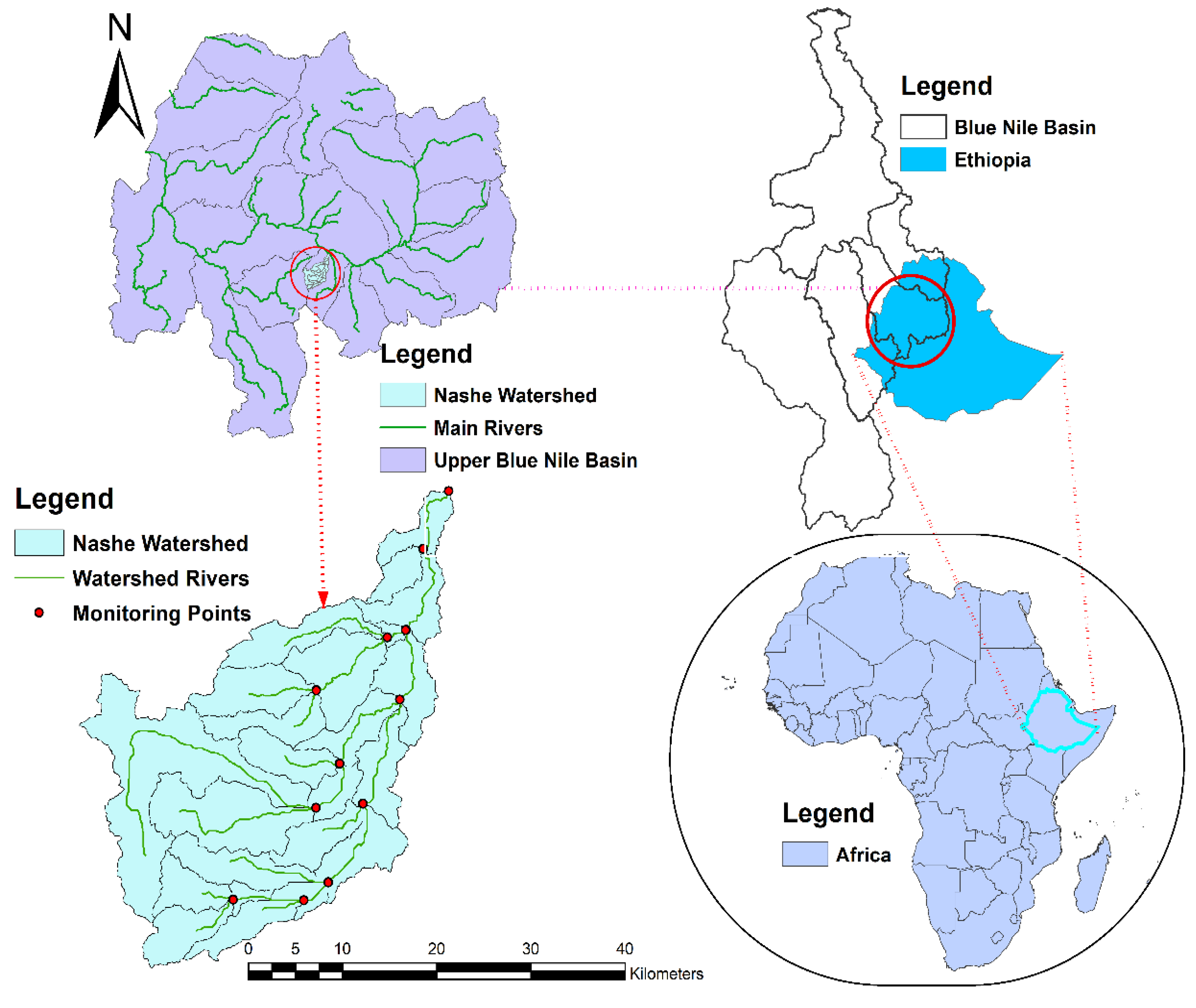
2.1. Description of the Study Watershed

The Nashe River originates from a long and wide river valley in the high mountainous area of Ethiopia. The land relief is up-down, with a low ridge separating the Nashe River from the adjacent river basins. The Nashe dam site is located in the central Ethiopian highlands, about 300 km northwest of the capital of Ethiopia, Addis Ababa, on the Nashe River (Figure 1). The Nashe River basin is located on the plateau, with an average altitude of 2200 m. The watershed plateau is characterized by a hilly topography interspersed with high mountain ranges, volcanic cones, and deep gorges. The Nashe River has a sharp drop of about 600 m at the Nashe cliff, forming a fall and torrents. The river basin has a sub-tropical climate with distinct dry and wet seasons. The Nashe hydropower plant, which has a reservoir located on the left side bank of the Blue Nile River Basin, is the principal tributary, and is mainly utilized for electricity generation for the country. The Nashe dam was developed by building a homogeneous earth-fill dam across the Nashe River, with a height of 38 m, crest length of 1000 m, and a crest elevation of 2235 m. The total water storage capacity of the reservoir is 448 million cubic meters (MCM), of which 85 MCM is dead storage and 363 MCM is live storage.
The watershed is geographically found between 9°35′ to 9°52′ N latitudes and 37°00′ to 37°20′ E longitudes. The purpose of the Nashe reservoir is primarily for hydropower production, with a total installed capacity of 97 MW in two 48.5 MW Pelton turbines installed at an elevation of 1614 masl (meters above sea level) at the surface powerhouse. The project is aimed to irrigate 6000 ha of land area downstream of the watershed for sugar cane cultivation. The annual mean temperature and rainfall of the watershed are 22 °C and range from 1200 mm to 1600 mm, respectively. Agricultural land and Haplic Alisols are the dominant LULC and soil types of the watershed, respectively.

2.2. Input Data Sets

2.2.1. Hydrological and Meteorological Data

In order to achieve the research goal, it is critical to have relevant and appropriate data before the simulation and optimization of any model [53]. The historical, current, and future hydrological data corresponding to LULC change scenarios have been investigated. The observed stream flow data of the watershed was used for comparison with the simulation results. The SWAT2012 hydrological model was used to examine the historical and future stream flow of the watershed, considering LULC changes. The necessary input data used for the SWAT model to simulate the stream flow of the watershed were DEM (Digital Elevation Model), weather data (rainfall, temperature, wind speed, relative humidity, and solar radiation), land use land cover data, soil data, and observed stream flow data.
The results of these hydrological simulations are instead used as input into an optimization model that determines the optimal reservoir operations given a time series of reservoir inflows. The reservoir’s stream flow prediction has been carried out by changing LULC maps, while the remaining model parameters from the calibrated model and other SWAT inputs remain constant. The observed historical stream flow data, soil, and DEM of the Nashe watershed were collected from the Ministry of Water, Irrigation, and Energy, Ethiopia. The weather data was obtained from the Meteorological Service Agency, Ethiopia.

2.2.2. Reservoir Data

The following data is typically required when using the HEC-ResPRM model to perform the reservoir operation: elevation-area-storage curve, historical reservoir storage and water surface level, reservoir outlet capacities, outflow-energy generation relationship, power production, background map of the watershed, and flow time series. The calibrated and validated SWAT model was used to estimate reservoir inflow data for the Nashe watershed [24]. The background map is helpful for setting up the model and visualizing its spatial layout, whereas the physical data is utilized to develop model constraints and allow the model to calculate penalties.
Therefore, the inflow data were first configured in the HEC-DSS (Hydrologic Engineering Center- Data Storage System) for efficient storage and retrieval of scientific input and output time series data. The historical flow time series data was collected from the Ministry of Water, Irrigation, and Energy of Ethiopia. The background map of the study area was extracted by importing the geo-referenced GIS data map of the watershed area using ArcGIS. The other required reservoir data were collected from the Ethiopian Electric Power Corporation.

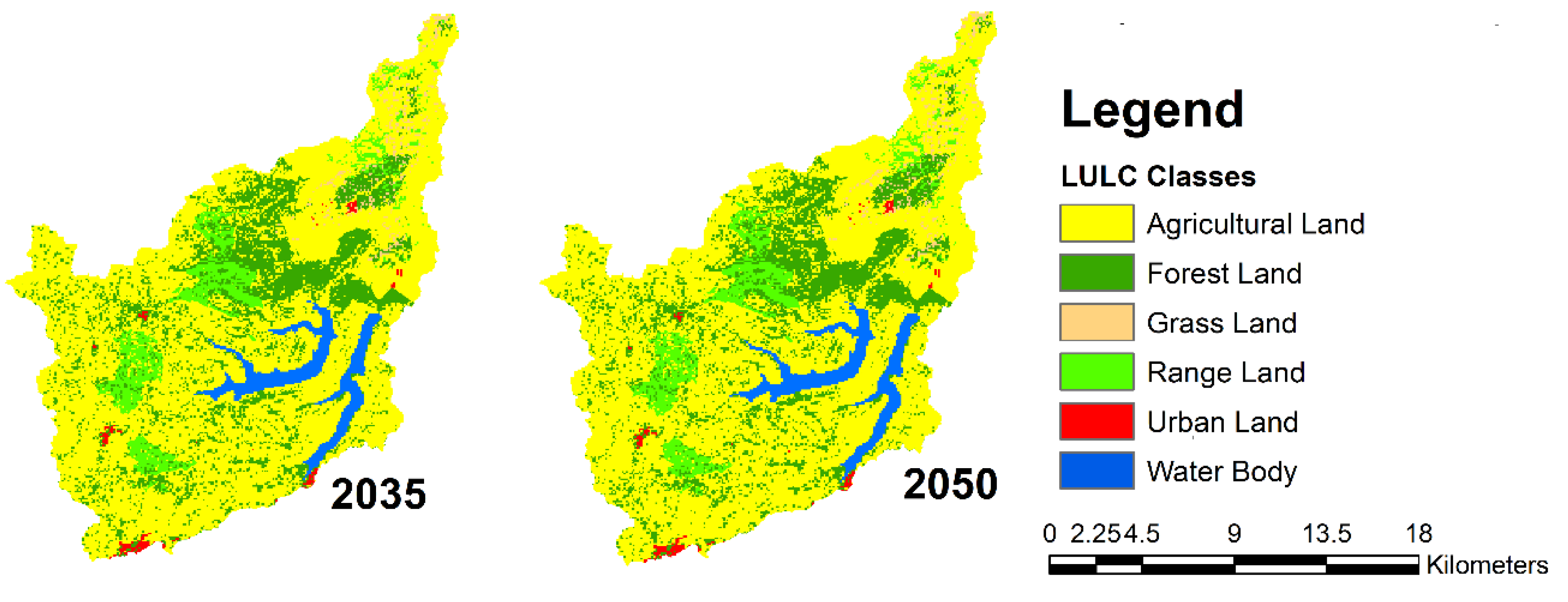
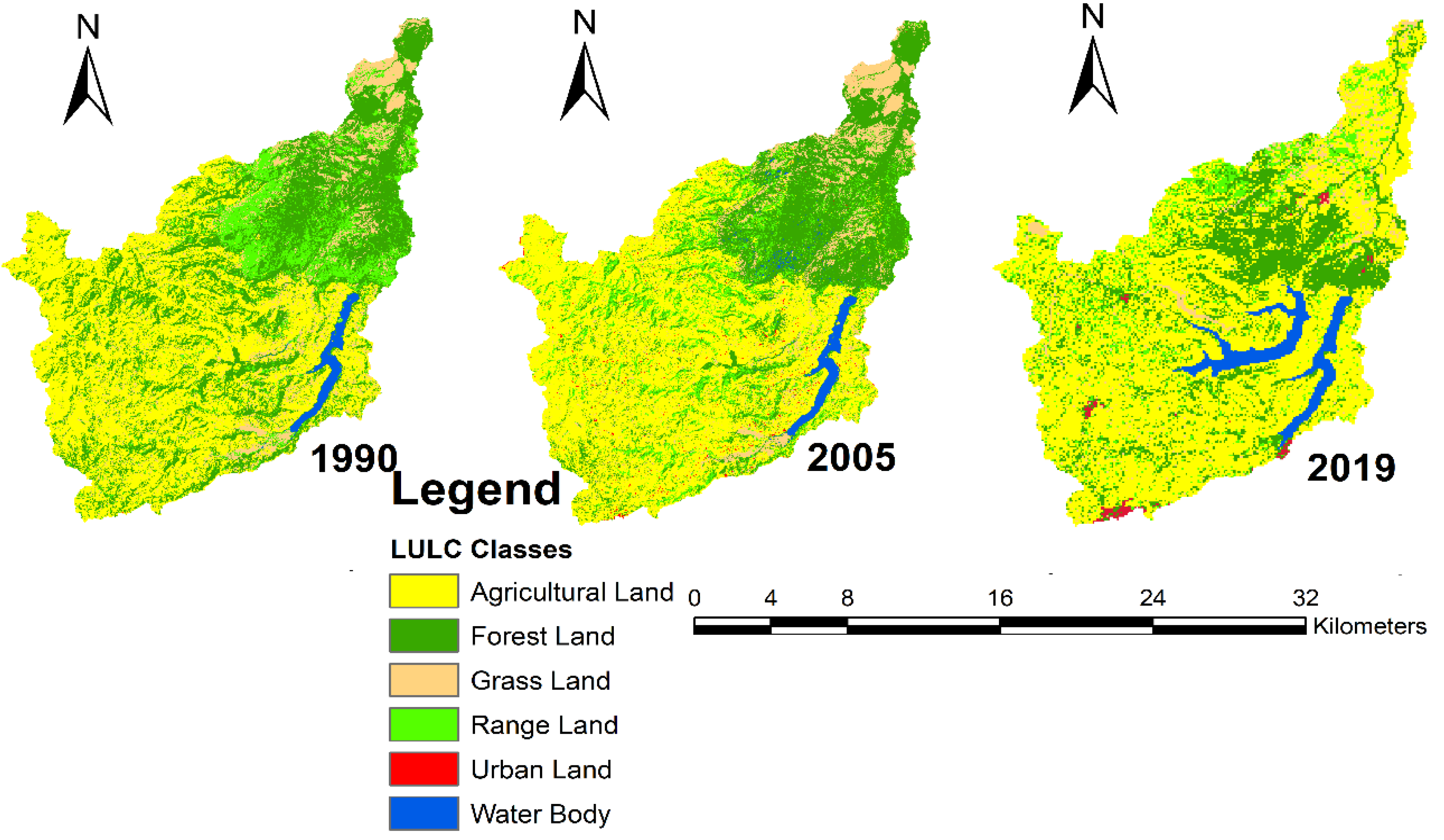
2.3. Land Use Land Cover Change Scenarios

Changes in land use land cover affect a catchment’s hydrological cycle through altering rainfall, evaporation, and runoff. The impact of LUCC on surface runoff has been related to land use types. The LULC types are one of the SWAT model’s input parameters. One of the most important factors influencing surface runoff generation is LULC change within a watershed [24,29,54]. In order to investigate the spatiotemporal dynamics of LULC and to predict future LULC change in the Nashe watershed, an integrated method that includes remote sensing, GIS, and a Multi-Layer Perceptron Neural Network-based Cellular Automata-Markov Chain model was employed by Leta et al. [14]. The historical LULC maps developed from Landsat images for the years 1990, 2005, and 2019 (Figure 2) were utilized as the base map and imported into the TerrSet model’s Land Change Modeler (LCM) interface to develop the future LULC maps and change scenarios for the years 2035 and 2050 [14] (Figure 3).
The potential LULC change in the watershed was examined using the LCM TerrSet software [14,55]. According to Leta et al. [14], the accuracy of the classified map was compared to ground truth data, and the model was validated for the predicted LULC by simulating the recent LULC map of 2019. The percentage changes of the historical and future LULC change were conducted by [14] and adopted in this study. Based on available land use maps, LCM is extensively used to simulate the projection of LULC changes between two periods. The comprehensive framework of the study is depicted in Figure 4.
The LULC results between 1990 and 2050 revealed a significant change. From 2035 to 2050, agricultural lands, urban areas, and water bodies were predicted to increase continuously. However, compared to the result of the previous change, the rate of agricultural land expansion is lower. This might be due to the limited area of land available for the agricultural land expansion. Furthermore, the distances from urban areas and water bodies could also be another possible reason.
The LULC types of the study watershed include agricultural land, forest land, grass land, range land, water body, and urban areas. Essentially, transition potential maps were developed and processed, after which the data were linked from the current time LULC map to the predicted time. The SWAT model was used to examine the existing and future stream flow of the reservoir using current and future LULC maps as inputs.

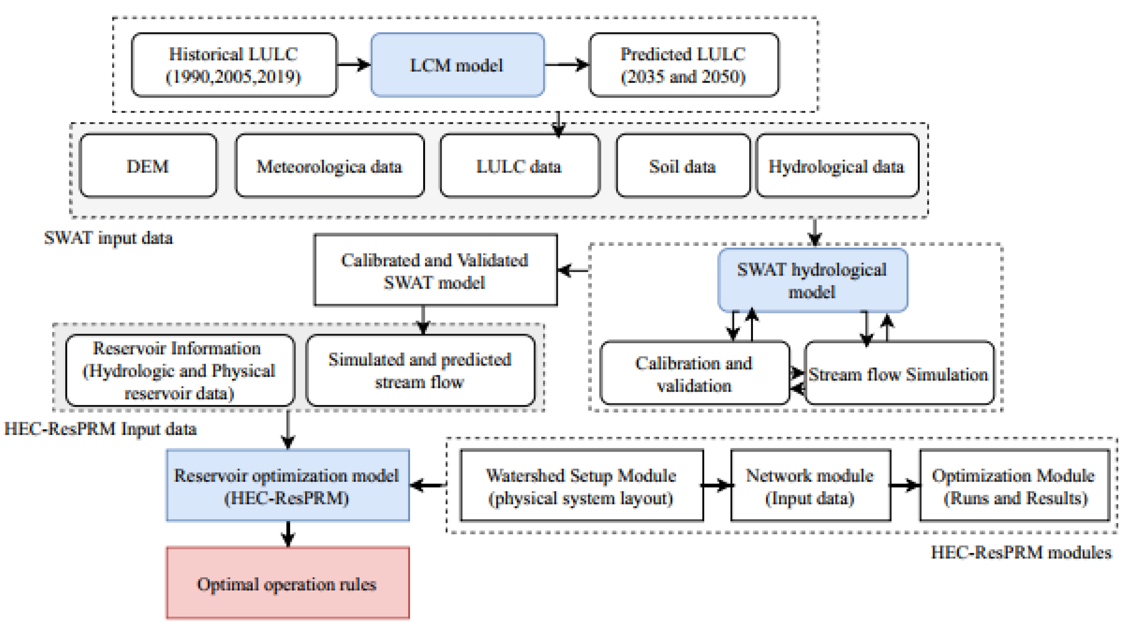
2.4. Model Development

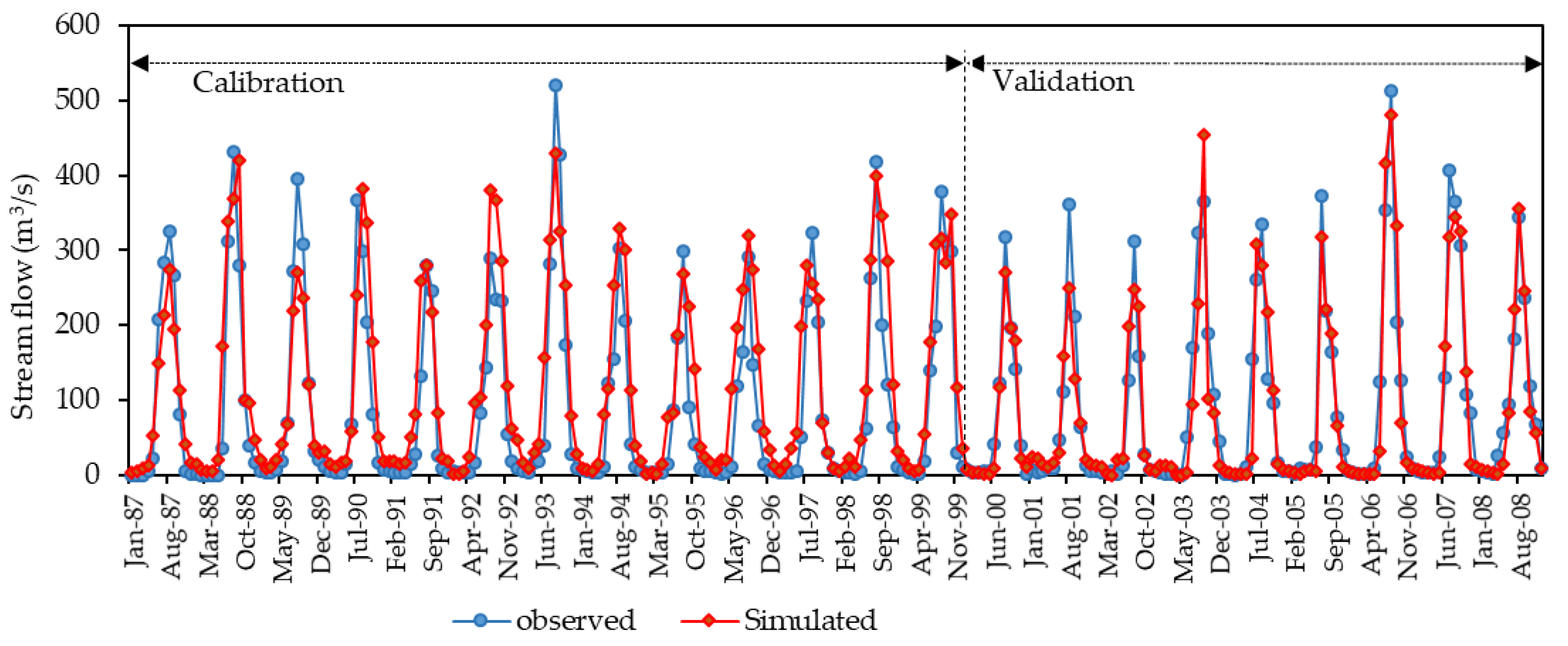
2.4.1. SWAT Hydrological Model

The Soil and Water Assessment Tool is a hydrological model that has been used for investigation of hydrological processes, reservoir operation, assessing the impact of LULC change, climate change on water resources, and for evaluating the effects of land management practices at the level of a watershed that operates over a daily period of time [24,54,56,57]. Precipitation, evapotranspiration, surface runoff, peak runoff, percolation, lateral flows, transmission losses, and ground water flows are the primary components required in the surface and ground water hydrology assessed by the SWAT. In order to simulate the future inflow projections and analyze the LULC change impact on the stream flow utilized as an input for reservoir operation, this study applied the SWAT hydrological model.
It is crucial to consider the impact of different parameters on how much the model simulates the hydrological processes in a watershed. The method of identifying the most substantial parameters for the model is by using sensitivity analysis. The sensitive parameters should be identified in order to improve the hydrological model’s calibration. The most sensitive parameters identified by Leta et al. [24] were adopted in this study. The SWAT splits the watershed into hydrologic response units (HRUs) based on topography, each of which has homogeneous land use, soil properties, slope, and estimates the relative effects of soil and LULC changes within each hydrologic response unit (HRU) [24,54].
The flow in each HRU is further simulated according to the hydrologic cycle equation Equation (1). The watershed of the Nashe has been divided into 23 sub-basins and 321 hydrological response units. The sensitivity analysis, model calibration, and validation were conducted to adjust and confirm the parameters in order to optimize the agreement between the observed and simulated stream flow of the Nashe watershed. In order to assess the goodness of the SWAT hydrological model in the Nashe watershed, the coefficients of determination (R2), Nash–Sutcliffe efficiency (NSE), and percent bias (PBIAS) were implemented. Detailed information about model input, sensitivity analysis, calibration, validation, and model performance assessment has been given by Leta et al. [24].
SWt = SWo + i = 1 n ( Rday QSurf Ea Wseep Qgw )
where SWt: final soil water content (mm H2O); SWo: initial water content (mm H2O); Rday: precipitation on day i (mm H2O); Qsurf: surface runoff on day i (mm H2O); Ea: evapotranspiration on day i (mm H2O); Wseep: water entering the vadose zone from the soil profile on day i (mm H2O); Qgw: return flow on day i (mm H2O); and t: time (days).

2.4.2. HEC-ResPRM Model Description and Setup

The HEC-ResPRM, a hybrid reservoir system optimization operation developed by Hydrologic US Army Corps of Engineering Centers, has been implemented to support planners, operators, and managers with reservoir operation planning and decision making. The reservoir system is modeled as a network of nodes and arcs by the network flow programming algorithm developed in HEC-ResPRM. The HEC-ResPRM modeling platform was developed to facilitate the joint development and use of simulation and optimization models in reservoir system planning and management, by coupling the HEC-PRM (Hydrologic Engineering Center-Prescriptive Reservoir Model) in graphical user interfaces (GUIs) shared with HEC-Res (common interface to both HEC-ResSIM and HEC-ResPRM) [58].
The HEC-ResPRM model stores and retrieves input and output time series data using HEC-DSS. The system is characterized as a network of nodes (reservoirs and junctions) and conveyance links with gain/loss coefficients. The optimization problem represented by a network flow system implemented in the HEC-ResPRM model with costs associated with the flow can be described as follows:
Minimize :   k n C k Q k
Subject   to :   Q k a k Q k = 0   ( For   all   nodes )
L k Q k U k   ( For   all   arcs )
where n is the total number of network arcs; Ck is unit cost, weighting factor for flow along arc k; Qk is flow along arc k; ak is multiplier (gain) for arc k; Lk is lower bound on flow along the arc k; and Uk is upper bound on flow along the arc k.
The arcs represent the outflow and inflow links in the reservoir system, whereas the node represents a river and reservoir, or channel junctions in this case. Equation (2) depicts the objective function of the flow network optimization model, which minimizes the cost of the flow network. Equation (3) represents model constraints and the continuity equation at each node of the flow network. Equation (4) represents the model constraint, and the maximum and minimum flow constraints at each arc.
The reservoir simulation model is based on the water balance for tracking the movement of water through a reservoir-stream system [59], which fluctuates from time to time. The HEC-ResPRM model allows modelers to create penalty functions that reflect system objectives by relating storage or flow with cost or benefit that derive the solution to the optimization problem. Penalty functions combine a penalty (cost) or reward (negative penalty) with the designated levels of storage or flow. The penalty functions characterize the relative economic, social, environmental, and political penalties linked to the failure to achieve operational goals (storage, pool level, and power production). As a result of unavailable cost data, making penalty functions that reflect costs is a complex economic activity in this study. Therefore, the two categories of penalty functions expressed in the Nashe watershed are storage and flow.
In this study, the constraint values for reservoirs are the lower and upper bounds of reservoir storage. Penalty functions for hydropower releases and storage were established when the inflow time series was specified and reservoir constraints were added. Consequently, as long as the volume of the reservoirs is between the MFL (maximum flood level) and the MOL (minimum operating level), the cost of storage will be zero; if these values are exceeded or not reached, then penalties are applied in the Nashe watershed. The penalties applied in this study were done by changing the shape or magnitude of penalty curves, and by changing the initial and ending reservoir storage volumes.

2.5. Reservoir Optimization Operation

An effective reservoir operation requires policies that optimize releases from the reservoir or storage volume in order to achieve the desired objectives, such as maximizing power generation or minimizing operation costs. The reservoir’s water yield is determined by the stream flow flowing into the reservoir in each time period, since the model’s principle is predicated on water balance [59]. Mostly, throughout the process of water balance determination, the storage capacity must be determined first, then the water release can be computed using the standard operating rule curves. The rule curves consist of lower and upper limits to guide the release to different water demand target levels.
The power generation requirement can be expressed in various hydropower rules as a relationship between storage and seasons; it can also be directly expressed as an external time series in some circumstances. If the available water is greater than the upper rule curve level, water is discharged from the reservoir into the downstream river; if it is below the lower rule curve, a reduction in supply is required to maintain the water level at the conservation zone. The management of the reservoir for maximum efficiency using basic tools to release water following reservoir rule curves for which LULC change relationships has been studied [60], including improved reservoir rule curves that are appropriate for the dynamics of the hydrological environment in the future [61].
Therefore, the available water in the reservoir should be managed between the upper and lower rule curve levels. The Nashe hydropower reservoir has three major water management zones, which are the inactive (dead storage) zone, the conservation zone, and the flood control zone. In this study, the two boundary rule curves (upper and lower) are used to define the operational zones of the Nashe reservoir that yield greater energy generation. Basically, three types of rule curves, the lower rule curve, upper rule curve, and operating rule curve, were developed and used in operating a reservoir. The operation of the Nashe hydropower reservoir was investigated in this study under three LULC scenarios (2019, 2035, and 2050). Optimization was attempted using alternative options for the three scenarios in order to establish the dynamic features of the reservoir and to determine the optimal solution that could generate maximum energy.

3. Results and Discussion

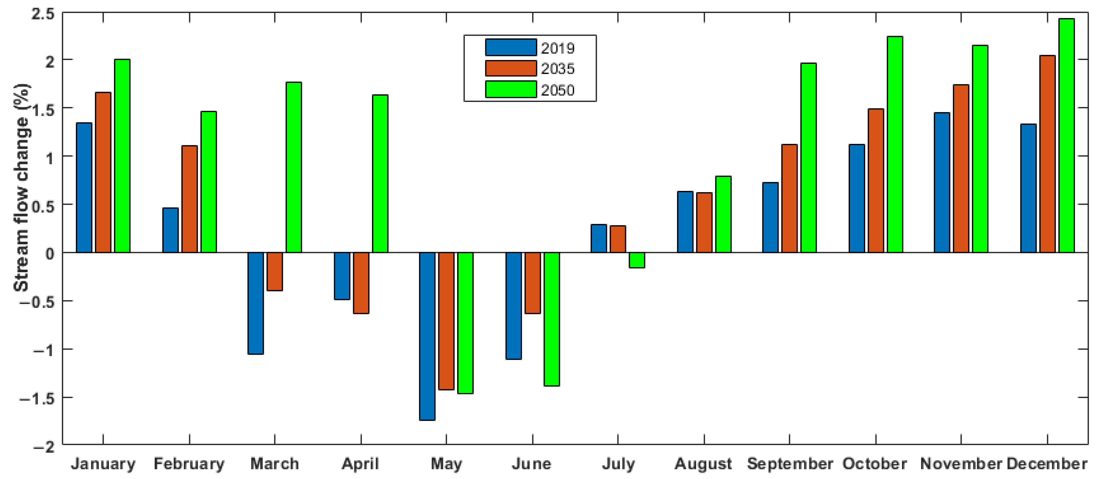
3.1. Reservoir Inflow under Land Use Land Cover Change

Land use land cover change has an impact on stream flow, which is a critical hydrological response used in water resource management planning and environmental assessments [62]. The influences of LULC change on annual, seasonal, and monthly stream flow were investigated with regard to the baseline period of 1990, and to 2005 for the current (2019) and future (2035 and 2050) LULC changes. Multiple land use transitions in the watershed were projected using the Land Change Modeler integrated TerrSet model [14]. The stream flow corresponding to the individual LULC variations was simulated using the SWAT hydrological model. The SWAT model was calibrated and validated from 1987 to 1999, and from 2000 to 2008, respectively, on a monthly basis.
The model result shows a strong correlation between the simulated and observed stream flows for the calibration and validation periods, as depicted in Figure 5. A detailed investigation of SWAT model performance utilizing graphical and statistical evaluation was presented by [24]. The study conducted by Leta et al. [24] on the hydrological responses of the watershed to historical and future LULC changes of the Nashe watershed, proved the efficacy of the SWAT model to simulate stream flow under varying time periods of LULC changes. The calibrated and validated SWAT model was simulated using inputs of the soil data, DEM, weather data, and projected LULC data, in order to simulate future reservoir inflow. As a result, the future reservoir inflow variation as a function of LULC change was projected using the calibrated SWAT model.
The average annual changes of stream flow show 1.15%, 1.36%, and 1.62% in 2019, 2035, and 2050, respectively, with respect to the historical (2005) simulated stream flow. Consequently, the results indicate that the average annual future stream flow into the reservoir shows an increasing trend for all time periods. The trend of increment and decline depend upon the rate of LULC changes. Mostly, the stream flow slightly decreased in the short rainy season, and showed an increasing trend for the other seasons in the watershed. In particular, during the high rainfall season between June and September, the stream flow accounts for more than 70% of the total, whereas it is below 10% in the short rainfall season.
Figure 6 depicts the average monthly percentage change of current and predicted hydropower reservoir inflow patterns under LULC change impacts. The results are in agreement with the results of the study conducted by Sajikumar and Remya [63] on the impact of land use land cover change on inflow characteristics. The average monthly stream flow change shows a maximum increase of 2.43% in 2050, and a maximum decrease of 1.74% in 2019. The trend of monthly stream flow shows that, individually, there was an increasing trend from August to February, and a decreasing tendency from March to July.

3.2. Reservoir Operation

In this study, the operation of the hydropower reservoir of the Nashe was performed under current and future trends. The foremost purpose of the Nashe hydropower reservoir construction on the Nashe River was to generate hydropower energy, which will help to substantially meet the energy requirements of the country. Furthermore, the dam produces a managed flow throughout the year, in contrast to the fluctuating seasonal flows that existed prior to dam construction. This has resulted in significant potential for downstream irrigation operations, which would improve the performance of downstream activities that were not investigated in this study as a result of unavailable diversion structure data. Operational decisions have to be made in order to reasonably balance the effects on the storage capacity and water releases between reservoirs and users throughout the time periods that further affect power generation.
The HEC-ResPRM optimization operation model used the SWAT model’s simulated stream flow to determine the storage, elevation (pool level), and hydropower generation of the reservoir system. The optimization model was employed under current conditions (2012–2019) after the Nashe hydropower reservoir was constructed to assess the performance of the reservoir operating model in the future. The comparison between the current optimized and actual values of the Nashe hydropower reservoir operation is presented with respect to the dynamics of current flows, elevation, storage, and power production. According to the results, the optimized hydropower reservoir operation (storage and pool level) values exhibited an increase when compared to the current actual reservoir operation status (Figure 7 and Figure 8).
The aim of performance measures is to provide a mechanism to compare the effectiveness of the reservoir system in accomplishing specific objectives quantitatively for different operating plans. In addition to the current reservoir operation, optimization strategies for the sole purpose of hydropower generation are frequently used in the area of water resources management [18]. The average annual optimized reservoir power storage and reservoir pool level increased by 10.58 MCM and 3.12 m, respectively. Figure 9 shows the associated optimal hydropower generation compared to the actual hydropower output. As can be seen, optimized operation performs better. Since the total volume passing the turbines is generally the same in both operation scenarios, the add-on for power supply is mainly generated by an increased storage level, and with that, an increased water head.

3.3. Hydropower Generation under Land Use Land Cover Changes

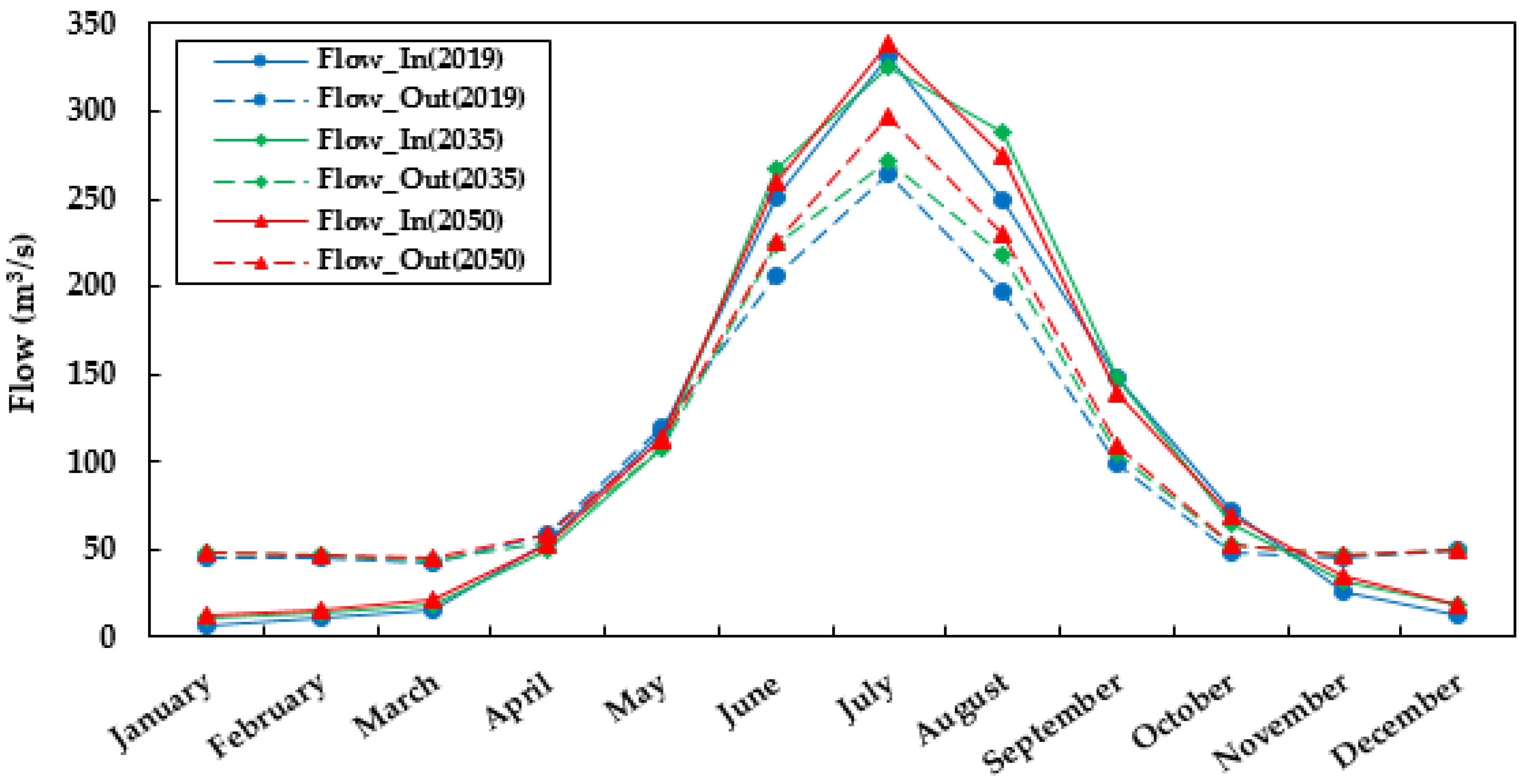
3.3.1. Reservoir Inflow and Outflow

The average simulated total inflows to the study hydropower reservoir show an increasing trend, as per the inflow prediction model under all LULC change scenarios. Inflows are also a limiting factor for mean hydropower. Releases (outflows) are used for the watershed optimization model to determine reservoir storage, water levels, and power generation. Similarly, the releases from the reservoir are utilized to assess the objective function for reservoir optimization, and depend on the water availability in the reservoir, prevailing users, and projected reservoir inflow. The surplus water release and water shortage, as well as the average annual shortage, were determined using the released water from the reservoir.
The optimization model was applied for the Nashe hydropower reservoir in order to generate the monthly optimal releases to meet the target demand of the watershed under LULC scenarios for the time periods of 2019, 2035, and 2050. In order to avoid the significant penalties associated with high releases, the model optimizes hydropower release using pre-release before high inflows. The HEC-ResPRM has knowledge of all inflows throughout the network. Thus, the reservoir release decisions are based on specified storage zones defined by elevation, and on a set of rules that specify the aims and constraints governing releases when the storage level falls within each zone. Therefore, the increased inflow in the development scenarios resulted in an accordingly adapted water release.
Correspondingly, the increased reservoir inflow also increases the reservoir outflow in all future periods, producing more energy from hydropower. According to Kangrang et al. [28], excess water release while increasing stream flow to produce more energy was demonstrated on active future rule curves for multipurpose reservoir operation under the effect of land use changes. As depicted in Figure 10, the results of optimal reservoir operation, including inflows and reservoir release, were compared to those of the current period. The volume of reservoir inflow begins to increase in May, and reaches its maximum in July, but afterward begins to decrease significantly from October, following the decline of rainfall. In addition to variations in mean monthly inflows and outflows, seasonal and annual distributions of inflows and outflows have also been investigated.
The increased outflow in the Nashe watershed will increase the inflow to the Grand Ethiopian Renaissance Dam. Thus, the downstream users also benefited from the increased stream flow in the future. Zhang et al. [64] found similar results following analysis of the inter-annual and decades scale stream flow variations of the GERD. Reservoir development, according to [9], intends to relieve regional water scarcity problems through the redistribution of water resources with temporal variability and spatial heterogeneity. Besides greater net benefits with increasing storage in Ethiopia, floods and droughts will be reduced, and the hydrological uncertainties will be nullified, particularly during low flow periods.
During the season of rain, the water volume flowing into the reservoir is typically at its maximum, making it difficult to control the excessive outflow. Similarly, as depicted in Figure 10, average outflow values were also highest during the wet season, mostly in June, July, August, while decreasing in the other seasons. The high runoff season of the study area begins mostly in June and ends in September. From November to April, it is the only base flow that flows into the reservoir. Similarly, during this time period, the outflow exceeds the inflow. From the results, it was observed that the average maximum monthly reservoir inflow ranges between 320 m3/s and 350 m3/s in 2019, 2035, and 2050.
The average monthly optimal reservoir inflow and releases (outflow) in the 2050 LULC change scenario are greater than the other scenarios in all time periods. Generally, plentiful rainfall in the wet season increased both the Nashe reservoir inflow and outflow. During the short rainy season, the difference between the inflows and outflows was minimal, especially in April and May. According to Guo et al. [15], future land use land cover changes will almost definitely continue to alter stream flow patterns, posing considerable reservoir management challenges.

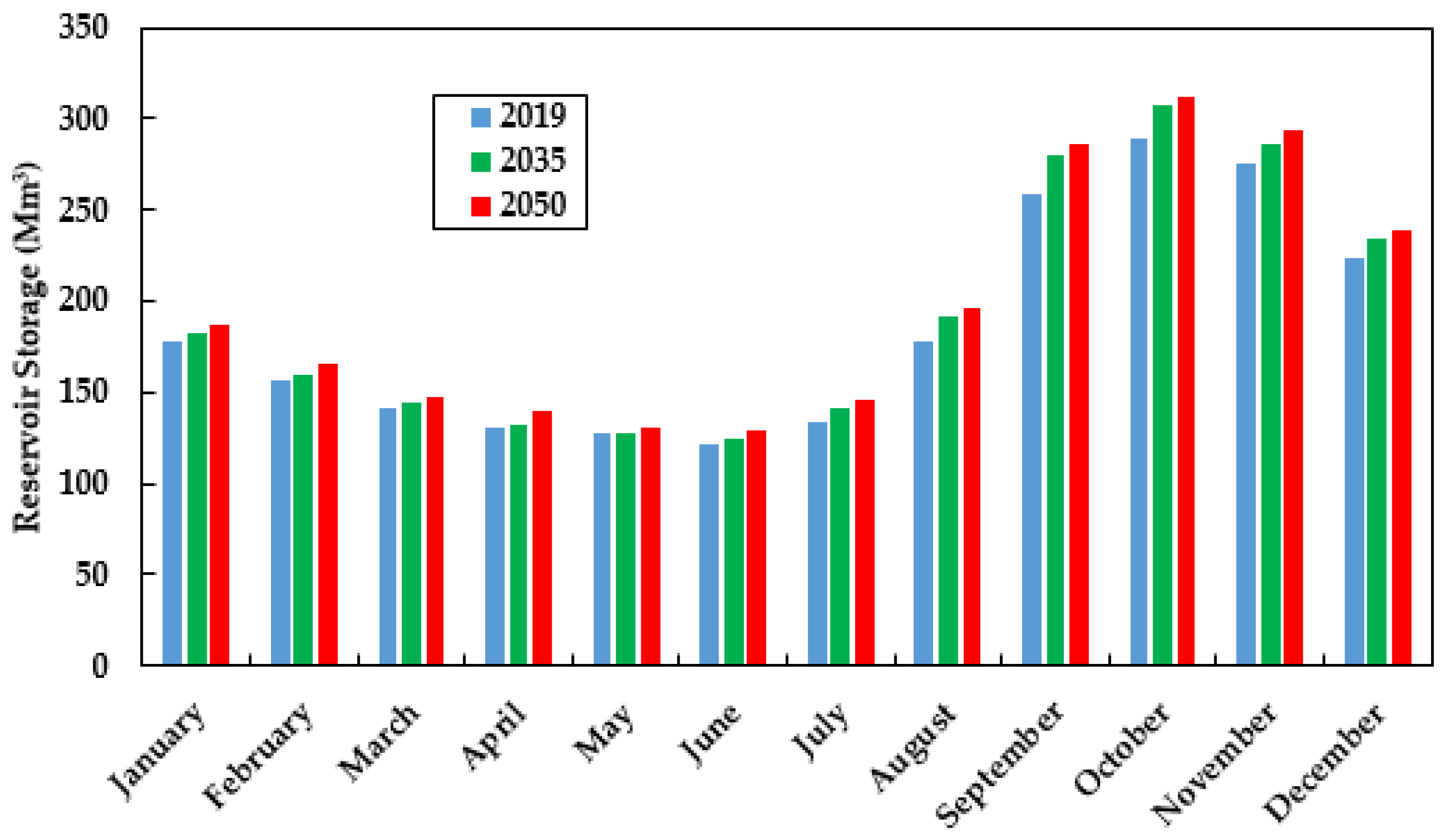
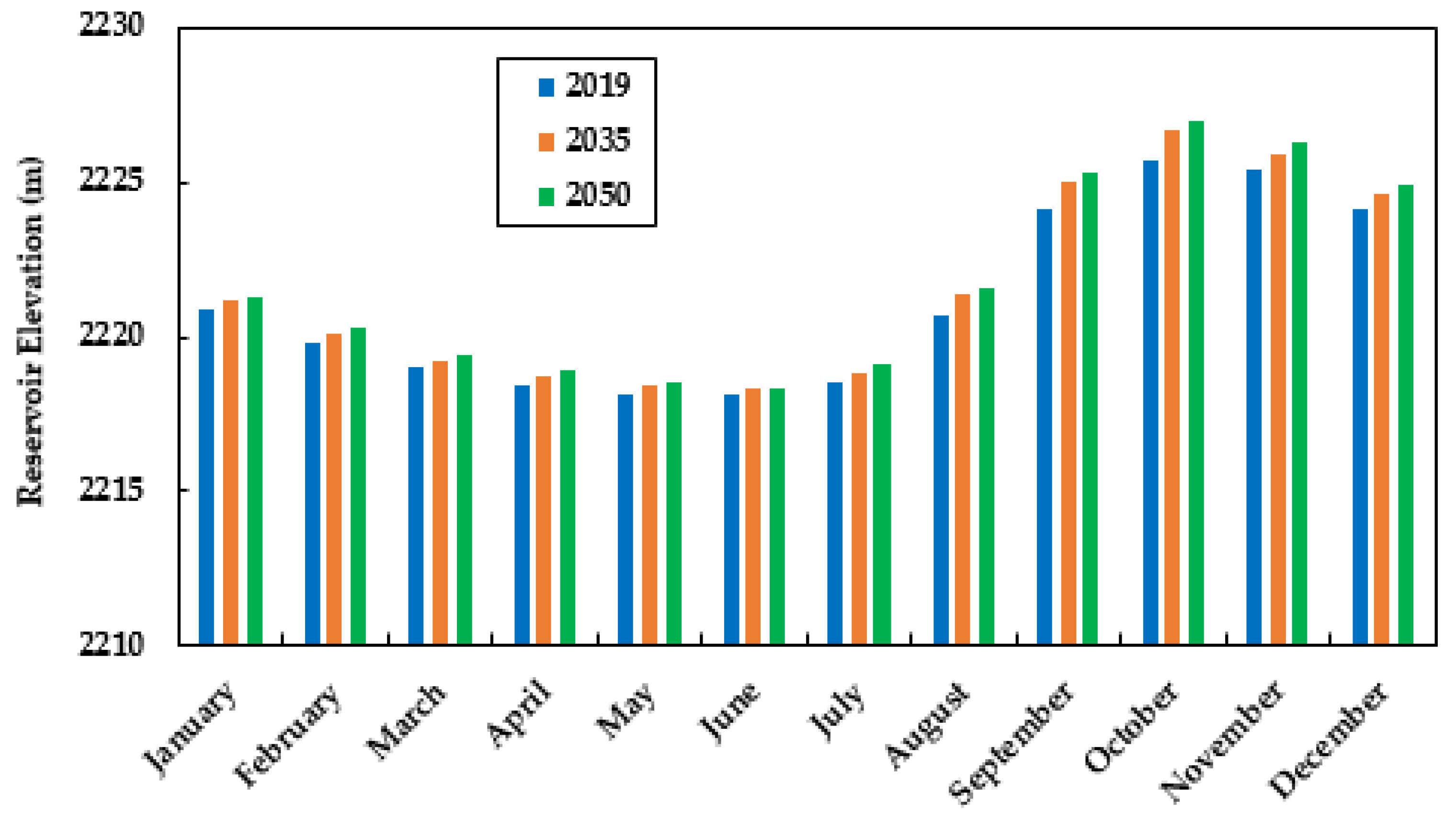
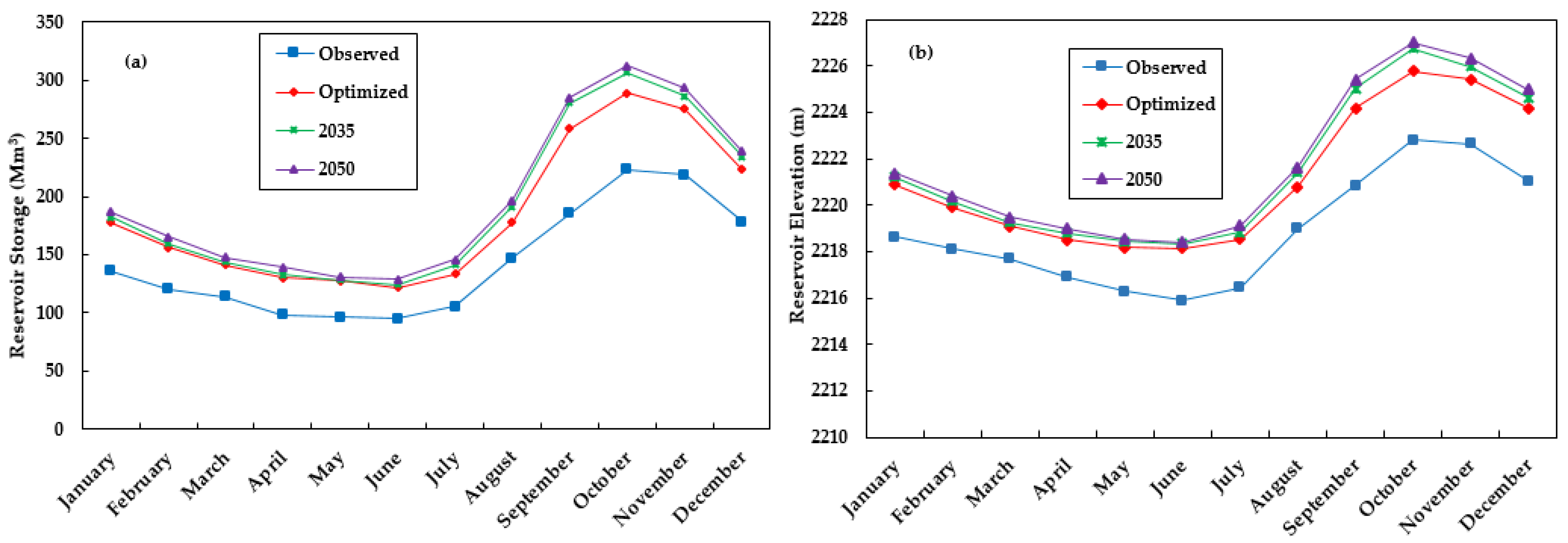
3.3.2. Reservoir Storage and Elevation

The desired storage, which was determined by applying the HEC-ResPRM model for hydropower generation, is a variable in the reservoir operation optimization model. The storage capacity of a reservoir varies, depending on inflow and outflow variations. However, the increment of reservoir inflow is the main factor for increasing reservoir storage. Therefore, the specified reservoir storage for the various operating strategies was achieved using the three time period (2019, 2035, and 2050) optimization scenarios. The reservoir optimization model results revealed a significant increase in predicted mean annual hydropower reservoir storage under the 2035 and 2050 LULC change scenarios of the Nashe watershed. Reservoir storage varies with inflow and outflow. The maximum average monthly optimum reservoir storage shows 289 million cubic meter (Mm3) in 2019, 307 Mm3 in 2035, and 313 Mm3 in 2050 (Figure 11).
The optimum reservoir storage occurred between September to December, with peak storage in October. The optimized future storage volumes for the reservoir within scenarios are greater than the current actual and optimized reservoir operations. However, most of the average storage volumes are close to the optimized current reservoir storage operation, especially during dry and short rainy seasons. Likewise, the storage volumes for the 2035 LULC scenario’s maximum volume are more comparable to the 2050 future scenario operation. According to [65,66] investigations, the optimum reservoir storage obtained by using the optimization algorithm for the reservoir should be better than the currently used operational storage for optimizing annual hydropower production. Figure 11 illustrates the average monthly reservoir storage results derived by the HEC-ResPRM optimization model for operations in 2019, 2035, and 2050.
In order to generate more head and hence more energy, the first scenario requires greater amounts of water storage within the reservoir relative to the second scenario. Furthermore, the findings depicted that the reservoir storage declined from the middle of February, and reached a minimum storage level in June. During this month, it helps to release more water volume in order to prepare for the next main rainy season. However, the simulation process determines the reservoir at each time step and the resulting downstream flows by considering the reservoir storage balance equation while keeping the system in balance. In conclusion, based on the results of the optimization model approach, power storage generation could be optimized, and should not result in significant water shortages in most of the years (Figure 11 and Figure 12).
Nevertheless, it is recommended to further decrease the spill of water during the wet season to avoid shortages of water in the following year. Therefore, the results show that the maximum reservoir storage in scenarios is more than the historical projected operations. This finding is in agreement with Lu et al. [1], Azizipour et al. [4], and He et al. [67] in their indications for the optimal levels of release and optimal volumes of storage in different parts of the world. The impacts of the change in LULC on the Nashe hydropower reservoir operation through the use of optimization models reveal a positive impact on the reservoir storage and its pool level. The major features of the reservoir pool define the volume of storage and the surface area at each level.
The Nashe hydropower reservoir pool level contains the relationship of the elevation-storage-area curve. The average monthly maximum and minimum reservoir levels for the future vary between 2226.76 m and 2227.01 m, and 2218.34 m and 2218.40 m, respectively, for the 2035 and 2050 LULC change scenarios, respectively. The results of reservoir elevation between operations in 2019, 2035, and 2050 were compared and are illustrated in Figure 12. From the results, it was observed that the optimized pool level is greater than the current optimal reservoir levels of the Nashe hydropower reservoir. This significant elevation difference will allow more water to be stored during the rainy season for energy production during the dry season.
Similar to reservoir storage, the reservoir pool level remains at a high level every year from September to December. However, the reservoir reaches a maximum level in October, near the end of the rainy season. In general, the findings show that the reservoir system has appropriate storage distributions and water allocations for the entire period. Hydropower generation is a priority when available water is above average and increased hydropower generation is required [6]. The reservoir authority and policymakers could use the various possible operational storage and elevation rules to assist them in developing efficient and long-term guidelines for several competing issues.

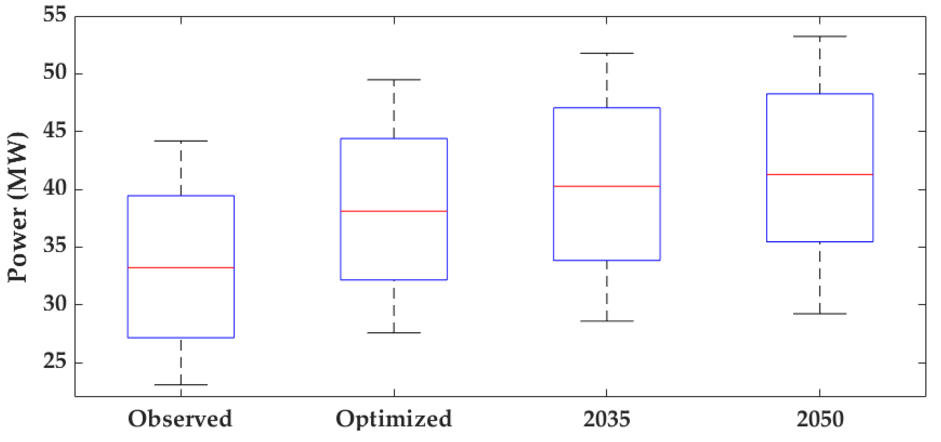
3.3.3. Reservoir Power Generation

The change in the hydropower generation caused by the LULC changes in the future scenarios (2035 and 2050) was explored by utilizing the current LULC scenario (2019) as a point of comparison. The optimization operation model employed the future stream flow data simulated by the SWAT hydrological model, and observed power production as input to develop the Nashe reservoir future power generation. The average annual power generation from the Nashe reservoir under different LULC time period scenarios (currently optimized and future), including the actual operation of the reservoir, is depicted in Figure 13. Therefore, Figure 13 shows that 2050 reservoir operation leads to improved power generation compared to the observed, optimized, 2019, and 2035 scenarios.
These findings propose that the outcomes of the future scenario optimization model are the most promising for increasing energy development. However, the fluctuations in power generation over time suggest that LULC changes have an impact on reservoir performance for energy production. Furthermore, the average annual energy production utilizing the HEC-ResPRM model for the 2035 and 2050 time periods is higher than that for the current actual and optimized energy generation of the reservoir. In comparison to the reservoir’s optimal operation in 2019; the average hydropower generation increased by 4.83%, and 8.32% for 2035 and 2050, respectively. As a result, when compared to earlier periods, this indicates a gradually increasing trend. Generally, there are no significant variations between the scenarios in terms of hydropower potential generation.
The results of the hydropower generation are consistent with the results of the stream flow simulation. The trend of average annual stream flow and hydropower generation show an increment in each of the future LULC time period scenarios due to the close relationship between hydropower generation and stream flow. Optimal hydropower occurs mostly during the rainy season under all scenarios, as a result of the increased inflow and water release. Between October and April, reservoir inflow decreases, resulting in a significant reduction in hydropower generation. In contrast, the increment of inflow from May to September contributes to a high pre-water level.
In all scenarios, the months of October to January, considered as dry months for the watershed, are projected to have a considerable increase in hydropower generation. Additionally, the peak value of hydropower generation is detected mostly in the wet season, especially in July, with minimum power generation happening in January. Similarly, the reason for a significant increment in inflow during the rainy period is that it encourages water impoundment, resulting in higher power output. Consequently, when the reservoir accumulates a high amount of water during the wet season, a high water level can be reached in the dry season, providing a larger water head for hydropower generation. Generally, reservoir management is expected to be affected by changes in the spatial and temporal availability of water at reservoir locations [68].

3.4. Optimal Operating Rule Curves

The operating rules for the reservoir system under this investigation were derived from the time series for reservoir storage and pool level generated by the optimization model during the entire period. It is necessary to obtain an appropriate guideline for effective reservoir storage and release balance, taking into consideration the project’s objectives for reservoir operation. Rule curves could be expressed in a number of ways, including water surface elevation or storage volume with respect to time of the year. The HEC-ResPRM optimization model was utilized to operate the current and future reservoir rule curves of the Nashe hydropower reservoir. Reservoir operation rule curves are the most frequent techniques used to determine the pace at which water is released and stored depending on currently existing information, such as the current status of storage volume and forecasted inflow [20]. The optimization results for the storage volume (Figure 14a) and pool level (Figure 14b) indicate that the 2035 and 2050 future scenarios rule curves are slightly higher than the current curves.
Figure 14 shows the optimal rule curves for the 2035 and 2050 scenarios in comparison to the existing rule curves. The rule curve features are based on the quantity of the inflow, which is ascribed to rainfall patterns and reservoir operation in proportion to monthly energy requirements. The power rule curves of the future scenarios also follow similar tendencies, but are higher compared to current optimized and efficient rule curves, with uneven power distribution from month to month. The 2050 LULC scenario rule curve shows the highest average power storage, reservoir level, power production, and total energy. According to [65,66], the optimal operating rules for reservoirs should be better than the current random operational rules using an optimization algorithm for annual hydropower production.
The reservoir operation focuses on the upper rule curves throughout the rainy season, since the volume of water flowing into the reservoir is very high, and is necessary to control the excess release reservoir operation focuses on the lower rule curves in the event of lower-than-average rainfall, resulting in low flow. The reservoir always wants to release more water than that entering the pool when the reservoir’s pool elevation is above the guide curve in flood control, and releases less water than that entering the pool when below the guide curve in conservation. In addition, the reservoir will be able to withstand the excessive volume of water that might finally lead to a flood, since it has more space to reserve excess amounts of water without an overflow situation.
Therefore, rule curves are crucial in order to control the effects of flash floods through dams. As a result, these curves can be suggested to be guidelines for reservoir operation, ensuring that all water demands are satisfied on a monthly basis. In general, all demands are satisfied as long as the reservoir’s current water levels and storage fall between the upper and lower rule curves. The water level in the Nashe reservoir is generally in the conservation zone, which is a safe zone for power generation, and reduces risks to dam safety and other structures. Therefore, the curves show the desired storage levels in the reservoir during the operation of reservoirs to satisfy the demands of hydropower production, environmental release, and flood protection.
The model’s optimized rule curve indicates that the reservoir’s maximum water level is about 2227.01 masl (Figure 14b), while the full reservoir level is 2230 masl. The study by Prasanchum and Kangrang [16] proved that the new rule curves can be helpful when connected to the simulation model, and this could prevent water shortages in the future. Generally, in the Nashe watershed, decisions based on reservoir operating rule curves are critical to achieving seasonally and annually balanced water release, as well as protecting reservoir downstream areas from flooding.

4. Conclusions

In this study, the LULC changes from the Land Change Modeler, which represent the current and future prediction scenarios, were assessed in order to determine the base and future inflows into the Nashe hydropower reservoir. As a result, the calibrated and validated SWAT model was utilized to generate LULC change-driven stream flow, which was then used as an input for modeling optimal reservoir operation. The reservoir optimization model has been utilized to develop optimal hydropower reservoir operation policies (storage and releases) for the Nashe hydropower reservoir, using a combination of the SWAT and the HEC-ResPRM optimization algorithm; this was implemented in order to meet the target storage and maximize reservoir capacity to generate hydropower under current and future LULC conditions. The following conclusions were reached as a result of the study’s key contributions:
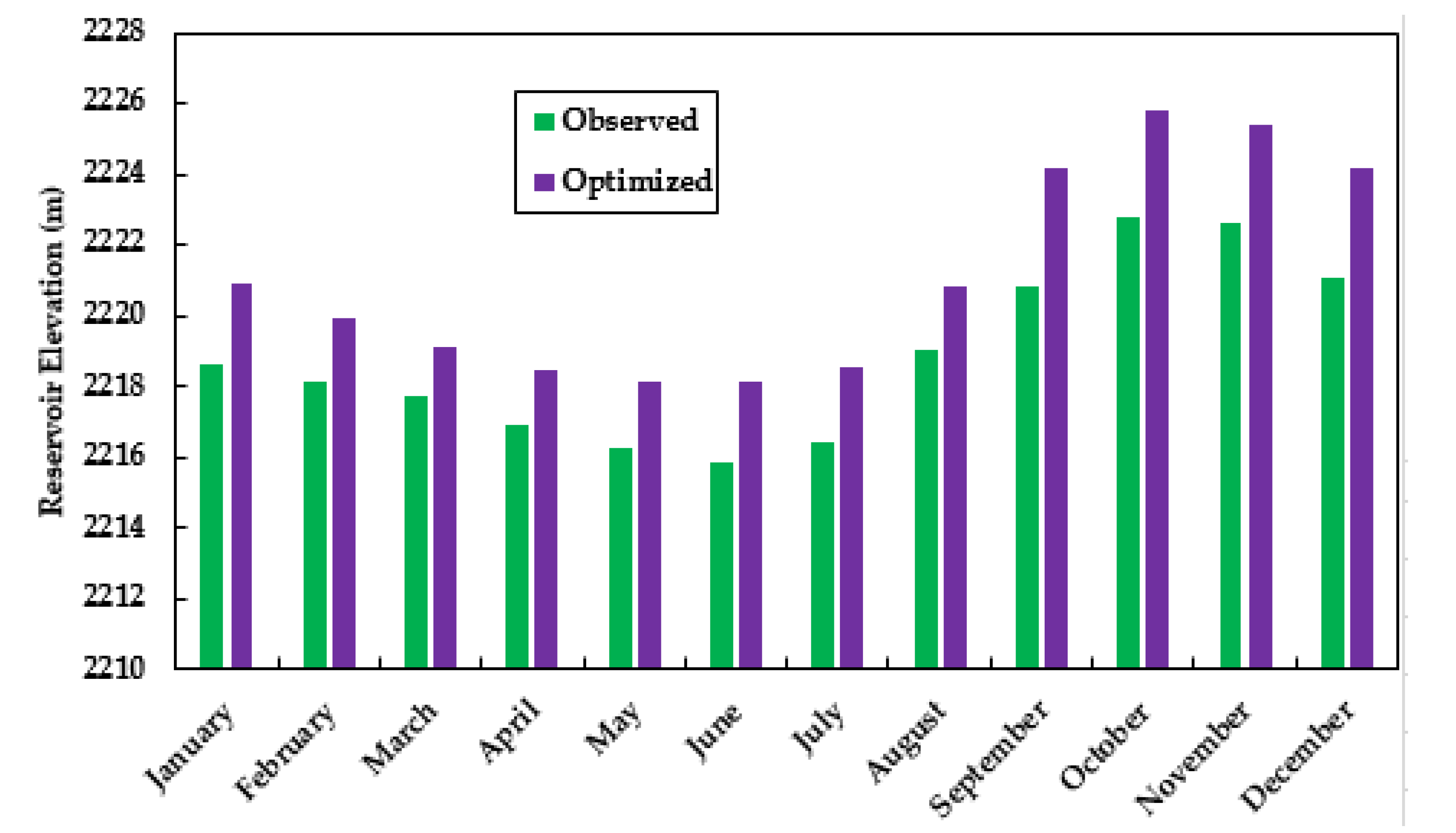
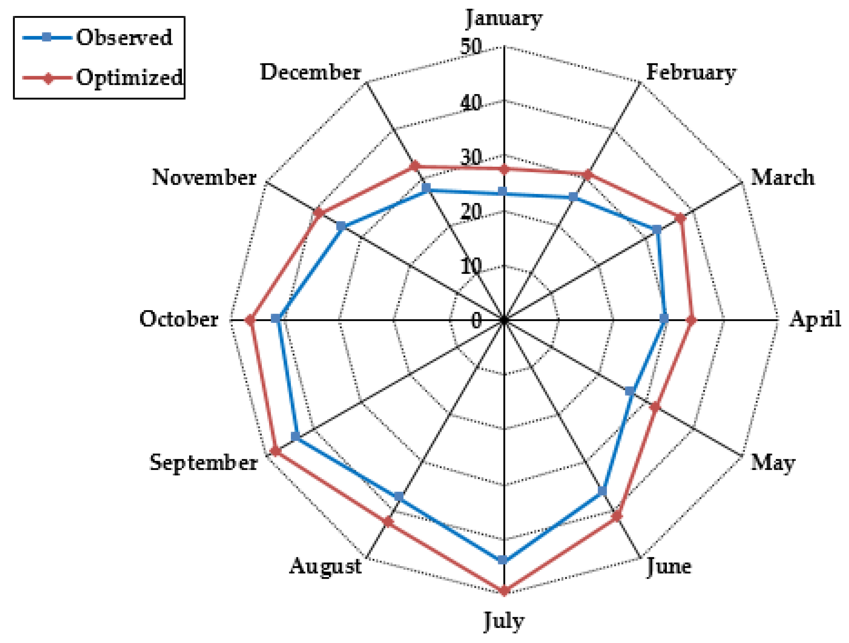
The estimated optimal reservoir operations for all scenarios have distinct values but follow similar tendencies. This indicates that the seasonal hydropower generation is affected by stream flow, and that the future inflow from the reservoir area is substantially more susceptible to future LULC changes. The optimal rule curves that were developed perform significantly better under future inflow scenarios compared to current rule curves, which allow the reservoir to be more effective and appropriate in terms of water release and storage for future scenarios to generate more energy.
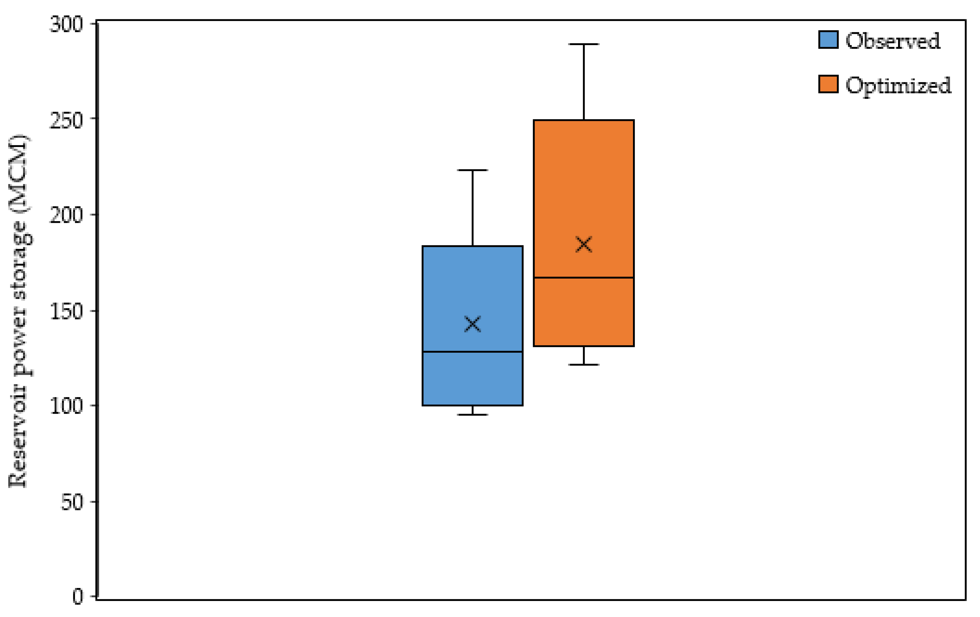
The optimal solution could maintain a higher level of water in the reservoir, and the optimized policy may increase hydropower generation during the wet season, while also increasing the possibility of water accessibility during the following dry season.
The possibility of improved water resource utilization in the future, particularly with vigorous operating rules that consider optimization and uncertainty, can be utilized as a guide for the future operation of hydropower planning. The development of appropriate reservoir operating rules is critical for planning and management, particularly from the perspective of LULC change.
The findings are intended to provide information to policymakers, water resource managers, and other interested stakeholders so that future development in the Nashe watershed of the Blue Nile River Basin can be more effective.
Furthermore, the findings suggest that the methodology utilized in this research can be used to evaluate and optimize current systems, as well as emphasize the importance of using predicted land use land cover change as an assessment tool for reservoir management in the future.
Generally, changes in LULC have an impact on the quantity of water available for energy generation in hydropower reservoirs. Land use land cover changes can cause soil deterioration (silting), which can affect both the watershed and the reservoir level as a result of sediment transport, and thus exacerbate the negative effects of climate change.
As a result, it is essential to perform studies that take into account a variety of variables in order to produce accurate scenarios for the future availability of water resources for hydropower generation, and to define regulations for flexible reservoir operation.

Author Contributions

Conceptualization, M.K.L., T.A.D. and J.T.; development of the work methodology, M.K.L.; software, M.K.L.; validation, M.K.L., T.A.D. and J.T.; formal analysis, M.K.L.; investigation, M.K.L.; data curation, M.K.L.; writing original draft preparation, M.K.L.; writing review and editing, M.K.L., T.A.D. and J.T.; visualization, M.K.L.; supervision of the manuscript T.A.D. and J.T. All authors have read and agreed to the published version of the manuscript.

Funding

This research was part of the DAAD-EECBP Home Grown PhD Scholarship Program under (EECBP Homegrown PhD Program-2019).

Institutional Review Board Statement

Not applicable.

Informed Consent Statement

Not applicable.

Data Availability Statement

The authors can provide the data used in this study upon reasonable request.

Acknowledgments

The first author is grateful for the German Academic Exchange Service (DAAD) for providing a scholarship during the study. The authors would like to express their gratitude to the University of Rostock for financing the publication under the Open Access Publication funding program.

Conflicts of Interest

The authors declare no conflict of interest.

References

  1. Lu, B.; Li, K.; Zhang, H.; Wang, W.; Gu, H. Study on the optimal hydropower generation of Zhelin reservoir. J. Hydro-Environ. Res. 2013, 7, 270–278. [Google Scholar] [CrossRef]
  2. Yazdi, J.; Moridi, A. Interactive Reservoir-Watershed Modeling Framework for Integrated Water Quality Management. Water Resour. Manag. 2017, 31, 2105–2125. [Google Scholar] [CrossRef]
  3. Xu, M.; Li, C.; Wang, X.; Cai, Y.; Yue, W. Optimal water utilization and allocation in industrial sectors based on water footprint accounting in Dalian City, China. J. Clean. Prod. 2018, 176, 1283–1291. [Google Scholar] [CrossRef]
  4. Azizipour, M.; Ghalenoei, V.; Afshar, M.H.; Solis, S.S. Optimal Operation of Hydropower Reservoir Systems Using Weed Optimization Algorithm. Water Resour. Manag. 2016, 30, 3995–4009. [Google Scholar] [CrossRef]
  5. Birhanu, K.; Alamirew, T.; Dinka, M.O.; Ayalew, S.; Aklog, D. Optimizing Reservoir Operation Policy Using Chance Constraint Nonlinear Programming for Koga Irrigation Dam, Ethiopia. Water Resour. Manag. 2014, 28, 4957–4970. [Google Scholar] [CrossRef]
  6. Yang, T.; Gao, X.; Sellars, S.L.; Sorooshian, S. Improving the multi-objective evolutionary optimization algorithm for hydropower reservoir operations in the California Oroville-Thermalito complex. Environ. Model Softw. 2015, 69, 262–279. [Google Scholar] [CrossRef] [Green Version]
  7. Chou, F.N.-F.; Wu, C.-W. Stage-wise optimizing operating rules for flood control in a multi-purpose reservoir. J. Hydrol. 2015, 521, 245–260. [Google Scholar] [CrossRef]
  8. Daniel, A. Water Use and Operation Analysis of Water Resource Systems in Omo Gibe River Basin. Master’s Thesis, Addis Ababa University, Addis Ababa, Ethiopia, May 2011. [Google Scholar]
  9. Soleimani, S.; Bozorg-Haddad, O.; Loáiciga, H.A. Reservoir Operation Rules with Uncertainties in Reservoir Inflow and Agricultural Demand Derived with Stochastic Dynamic Programming. J. Irrig. Drain. Eng. 2016, 142, 04016046. [Google Scholar] [CrossRef] [Green Version]
  10. Feng, M.; Liu, P.; Guo, S.; Gui, Z.; Zhang, X.; Zhang, W.; Xiong, L. Identifying changing patterns of reservoir operating rules under various inflow alteration scenarios. Adv. Water Resour. 2017, 104, 23–36. [Google Scholar] [CrossRef]
  11. Sangiorgio, M.; Guariso, G. NN-Based Implicit Stochastic Optimization of Multi-Reservoir Systems Management. Water 2018, 10, 303. [Google Scholar] [CrossRef] [Green Version]
  12. Fayaed, S.S.; El-Shafie, A.; Jaafar, O. Reservoir-system simulation and optimization techniques. Stoch. Hydrol. Hydraul. 2013, 27, 1751–1772. [Google Scholar] [CrossRef]
  13. Zhou, J.; Jia, B.; Chen, X.; Qin, H.; He, Z.; Liu, G. Identifying Efficient Operating Rules for Hydropower Reservoirs Using System Dynamics Approach—A Case Study of Three Gorges Reservoir, China. Water 2019, 11, 2448. [Google Scholar] [CrossRef] [Green Version]
  14. Leta, M.; Demissie, T.; Tränckner, J. Modeling and Prediction of Land Use Land Cover Change Dynamics Based on Land Change Modeler (LCM) in Nashe Watershed, Upper Blue Nile Basin, Ethiopia. Sustainability 2021, 13, 3740. [Google Scholar] [CrossRef]
  15. Guo, Y.; Fang, G.; Xu, Y.-P.; Tian, X.; Xie, J. Responses of hydropower generation and sustainability to changes in reservoir policy, climate and land use under uncertainty: A case study of Xinanjiang Reservoir in China. J. Clean. Prod. 2020, 281, 124609. [Google Scholar] [CrossRef]
  16. Prasanchum, H.; Kangrang, A. Optimal reservoir rule curves under climatic and land use changes for Lampao Dam using Genetic Algorithm. KSCE J. Civ. Eng. 2017, 22, 351–364. [Google Scholar] [CrossRef]
  17. Asadieh, B.; Afshar, A. Optimization of Water-Supply and Hydropower Reservoir Operation Using the Charged System Search Algorithm. Hydrology 2019, 6, 5. [Google Scholar] [CrossRef] [Green Version]
  18. Fan, J.-L.; Hu, J.-W.; Zhang, X.; Kong, L.-S.; Li, F.; Mi, Z. Impacts of climate change on hydropower generation in China. Math. Comput. Simul. 2018, 167, 4–18. [Google Scholar] [CrossRef]
  19. Paliwal, V.; Ghare, A.D.; Mirajkar, A.B.; Bokde, N.D.; Lorenzo, A.E.F. Computer Modeling for the Operation Optimization of Mula Reservoir, Upper Godavari Basin, India, Using the Jaya Algorithm. Sustainability 2019, 12, 84. [Google Scholar] [CrossRef] [Green Version]
  20. Zhang, J.; Liu, P.; Wang, H.; Lei, X.; Zhou, Y. A Bayesian model averaging method for the derivation of reservoir operating rules. J. Hydrol. 2015, 528, 276–285. [Google Scholar] [CrossRef]
  21. Zuo, D.; Xu, Z.; Yao, W.; Jin, S.; Xiao, P.; Ran, D. Assessing the effects of changes in land use and climate on runoff and sediment yields from a watershed in the Loess Plateau of China. Sci. Total Environ. 2016, 544, 238–250. [Google Scholar] [CrossRef]
  22. Waseem, M.; Kachholz, F.; Tränckner, J. Suitability of common models to estimate hydrology and diffuse water pollution in North-eastern German lowland catchments with intensive agricultural land use. Front. Agric. Sci. Eng. 2018, 5, 420–431. [Google Scholar] [CrossRef] [Green Version]
  23. Kumari, N.; Srivastava, A.; Sahoo, B.; Raghuwanshi, N.S.; Bretreger, D. Identification of Suitable Hydrological Models for Streamflow Assessment in the Kangsabati River Basin, India, by Using Different Model Selection Scores. Nonrenew. Resour. 2021, 30, 4187–4205. [Google Scholar] [CrossRef]
  24. Leta, M.K.; Demissie, T.A.; Tränckner, J. Hydrological Responses of Watershed to Historical and Future Land Use Land Cover Change Dynamics of Nashe Watershed, Ethiopia. Water 2021, 13, 2372. [Google Scholar] [CrossRef]
  25. Zhang, L.; Meng, X.; Wang, H.; Yang, M. Simulated Runoff and Sediment Yield Responses to Land-Use Change Using the SWAT Model in Northeast China. Water 2019, 11, 915. [Google Scholar] [CrossRef] [Green Version]
  26. Anand, J.; Gosain, A.K.; Khosa, R. Optimisation of Multipurpose Reservoir Operation by Coupling Soil and Water Assessment Tool (SWAT) and Genetic Algorithm for Optimal Operating Policy (Case Study: Ganga River Basin). Sustainability 2018, 10, 1660. [Google Scholar] [CrossRef] [Green Version]
  27. Megersa, K.; Ankit, C.; Tamene, A. Stream Flow and Land Use Land Cover Change in Finchaa Hydropower, Blue Nile Basin, Ethiopia. Int. J. Civil. Struct. Environ. Infrastruct. Eng. Res. Dev. 2017, 7, 1–12. [Google Scholar] [CrossRef]
  28. Kangrang, A.; Prasanchum, H.; Hormwichian, R. Active future rule curves for multi-purpose reservoir operation on the impact of climate and land use changes. J. Hydro-Environ. Res. 2019, 24, 1–13. [Google Scholar] [CrossRef]
  29. Lin, B.; Chen, X.; Yao, H.; Chen, Y.; Liu, M.; Gao, L.; James, A. Analyses of landuse change impacts on catchment runoff using different time indicators based on SWAT model. Ecol. Indic. 2015, 58, 55–63. [Google Scholar] [CrossRef]
  30. Labadie, J.W. Optimal Operation of Multireservoir Systems: State-of-the-Art Review. J. Water Resour. Plan. Manag. 2004, 130, 93–111. [Google Scholar] [CrossRef]
  31. Rozos, E. An assessment of the operational freeware management tools for multi-reservoir systems. Water Supply 2018, 19, 995–1007. [Google Scholar] [CrossRef]
  32. Choi, Y.; Lee, E.; Ji, J.; Ahn, J.; Kim, T.; Yi, J. Development and Evaluation of the Hydropower Reservoir Rule Curve for a Sustainable Water Supply. Sustainability 2020, 12, 9641. [Google Scholar] [CrossRef]
  33. Ozkaya, A.; Zerberg, Y. Water storage change assessment in the Seyhan Reservoir (Turkey) using HEC-ResSim model. Arab. J. Geosci. 2021, 14, 1–12. [Google Scholar] [CrossRef]
  34. Zeng, X.; Hu, T.; Guo, X.; Li, X. Water Transfer Triggering Mechanism for Multi-Reservoir Operation in Inter-Basin Water Transfer-Supply Project. Water Resour. Manag. 2014, 28, 1293–1308. [Google Scholar] [CrossRef]
  35. Chou, F.N.-F.; Linh, N.T.T.; Wu, C.-W. Optimizing the Management Strategies of a Multi-Purpose Multi-Reservoir System in Vietnam. Water 2020, 12, 938. [Google Scholar] [CrossRef] [Green Version]
  36. Ehteram, M.; Koting, S.B.; Afan, H.A.; Mohd, N.S.; Malek, M.A.; Ahmed, A.N.; El-Shafie, A.H.; Onn, C.C.; Lai, S.H.; El-Shafie, A. New Evolutionary Algorithm for Optimizing Hydropower Generation Considering Multireservoir Systems. Appl. Sci. 2019, 9, 2280. [Google Scholar] [CrossRef] [Green Version]
  37. Nourani, V.; Rouzegari, N.; Molajou, A.; Hosseini, B.A. An integrated simulation-optimization framework to optimize the reservoir operation adapted to climate change scenarios. J. Hydrol. 2020, 587, 125018. [Google Scholar] [CrossRef]
  38. Nandalal, K.D.W.; Bogardi, J.J. Dynamic programming based operation of reservoirs: Applicability and limits. Dyn. Program Based Oper. Reserv. Appl. Limits 2013, 31, 1–130. [Google Scholar]
  39. Ashrafi, S.; Ashrafi, S.; Moazami, S. Developing Self-adaptive Melody Search Algorithm for Optimal Operation of Multi-reservoir Systems. J. Hydraul. Struct. 2017, 3, 35–48. [Google Scholar]
  40. Abera, F.F.; Asfaw, D.H.; Engida, A.N.; Melesse, A.M. Optimal Operation of Hydropower Reservoirs under Climate Change: The Case of Tekeze Reservoir, Eastern Nile. Water 2018, 10, 273. [Google Scholar] [CrossRef] [Green Version]
  41. Faber, B.A.; Harou, J.J. Multi-objective optimization of reservoir systems using HEC-ResPRM. Restoring Our Nat Habitat. In Proceedings of the 2007 World Environmental and Water Resources Congress, Tampa, FL, USA, 15–19 May 2007; pp. 1–14. [Google Scholar]
  42. Khare, D.; Patra, D.; Mondal, A.; Kundu, S. Impact of landuse/land cover change on run-off in the catchment of a hydro power project. Appl. Water Sci. 2015, 7, 787–800. [Google Scholar] [CrossRef]
  43. Bahati, H.K.; Ogenrwoth, A.; Sempewo, J.I. Quantifying the potential impacts of land-use and climate change on hydropower reliability of Muzizi hydropower plant, Uganda. J. Water Clim. Chang. 2021, 12, 2526–2554. [Google Scholar] [CrossRef]
  44. Nguyen, A.; Cochrane, T.; Pahlow, M. A Framework to Assess the Reliability of a Multipurpose Reservoir under Uncertainty in Land Use. Water 2021, 13, 287. [Google Scholar] [CrossRef]
  45. Falchetta, G.; Kasamba, C.; Parkinson, S.C. Monitoring hydropower reliability in Malawi with satellite data and machine learning. Environ. Res. Lett. 2019, 15, 014011. [Google Scholar] [CrossRef]
  46. Samaan, M.M. The Win-Win-Win Scenario in the Blue Nile’s Hydropolitical Game: Application on the Grand Ethiopian Renaissance Dam; GESIS-Leibniz-Institut für Sozialwissenschaften: Mannheim, Germany, 2014. [Google Scholar]
  47. Goor, Q.; Halleux, C.; Mohamed, Y.; Tilmant, A. Optimal operation of a multipurpose multireservoir system in the Eastern Nile River Basin. Hydrol. Earth Syst. Sci. 2010, 14, 1895–1908. [Google Scholar] [CrossRef] [Green Version]
  48. Jeuland, M.; Wu, X.; Whittington, D. Infrastructure development and the economics of cooperation in the Eastern Nile. Water Int. 2017, 42, 121–141. [Google Scholar] [CrossRef]
  49. McCartney, M.P.; Girma, M.M. Evaluating the downstream implications of planned water resource development in the Ethiopian portion of the Blue Nile River. Water Int. 2012, 37, 362–379. [Google Scholar] [CrossRef]
  50. Arjoon, D.; Mohamed, Y.; Goor, Q.; Tilmant, A. Hydro-economic risk assessment in the eastern Nile River basin. Water Resour. Econ. 2014, 8, 16–31. [Google Scholar] [CrossRef]
  51. Mulat, A.G.; Moges, S.A. Assessment of the Impact of the Grand Ethiopian Renaissance Dam on the Performance of the High Aswan Dam. J. Water Resour. Prot. 2014, 6, 583–598. [Google Scholar] [CrossRef] [Green Version]
  52. Yesuph, A.Y.; Dagnew, A.B. Land use/cover spatiotemporal dynamics, driving forces and implications at the Beshillo catchment of the Blue Nile Basin, North Eastern Highlands of Ethiopia. Environ. Syst. Res. 2019, 8, 21. [Google Scholar] [CrossRef] [Green Version]
  53. Fang, H.; Bin, H.T.S.; Zeng, X.; Wu, F.Y. Simulation-optimization model of reservoir operation based on target storage curves. Water Sci. Eng. 2014, 7, 433–445. [Google Scholar]
  54. Megersa, K.L.; Tamene, A.D.; Sifan, A.K. Impacts of Land Use Land Cover Change on Sediment Yield and Stream Flow. Int. J. Sci. Technol. 2017, 6, 763–781. [Google Scholar]
  55. Ansari, A.; Golabi, M.H. Prediction of spatial land use changes based on LCM in a GIS environment for Desert Wetlands—A case study: Meighan Wetland, Iran. Int. Soil Water Conserv. Res. 2018, 7, 64–70. [Google Scholar] [CrossRef]
  56. Buakhao, W.; Kangrang, A. DEM Resolution Impact on the Estimation of the Physical Characteristics of Watersheds by Using SWAT. Adv. Civ. Eng. 2016, 2016, 8180158. [Google Scholar] [CrossRef] [Green Version]
  57. Liu, Y.; Wang, W.; Hu, Y.; Cui, W. Improving the Distributed Hydrological Model Performance in Upper Huai River Basin: Using Streamflow Observations to Update the Basin States via the Ensemble Kalman Filter. Adv. Meteorol. 2016, 2016, 1–14. [Google Scholar] [CrossRef] [Green Version]
  58. USACE. HEC-ResPRM Prescriptive Reservoir Model-Quick Start Guide; U.S. Army Corps of Engineers, Institute for Water Resources, Hydrologic Engineering Center: Davis, CA, USA, 2011. [Google Scholar]
  59. Zhao, T.; Zhao, J. Optimizing Operation of Water Supply Reservoir: The Role of Constraints. Math. Probl. Eng. 2014, 2014, 853186. [Google Scholar] [CrossRef]
  60. Jothityangkoon, C.; Hirunteeyakul, C.; Boonrawd, K.; Sivapalan, M. Assessing the impact of climate and land use changes on extreme floods in a large tropical catchment. J. Hydrol. 2013, 490, 88–105. [Google Scholar] [CrossRef]
  61. Zhou, Y.; Guo, S. Incorporating ecological requirement into multipurpose reservoir operating rule curves for adaptation to climate change. J. Hydrol. 2013, 498, 153–164. [Google Scholar] [CrossRef] [Green Version]
  62. Srivastava, A.; Kumari, N.; Maza, M. Hydrological Response to Agricultural Land Use Heterogeneity Using Variable Infiltration Capacity Model. Water Resour. Manag. 2020, 34, 3779–3794. [Google Scholar] [CrossRef]
  63. Sajikumar, N.; Remya, R. Impact of land cover and land use change on runoff characteristics. J. Environ. Manag. 2015, 161, 460–468. [Google Scholar] [CrossRef]
  64. Zhang, Y.; Erkyihum, S.T.; Block, P. Filling the GERD: Evaluating hydroclimatic variability and impoundment strategies for Blue Nile riparian countries. Water Int. 2016, 41, 593–610. [Google Scholar] [CrossRef]
  65. Wu, Y.; Chen, J. Estimating irrigation water demand using an improved method and optimizing reservoir operation for water supply and hydropower generation: A case study of the Xinfengjiang reservoir in southern China. Agric. Water Manag. 2013, 116, 110–121. [Google Scholar] [CrossRef]
  66. Loucks, D.P.; van Eelco, B. Water resource systems planning and analysis-An Introduction to Methods, Models, and Applications. Adv. Water Resour. 2016, 4, 146. [Google Scholar]
  67. He, Y.; Xu, Q.; Yang, S.; Liao, L. Reservoir flood control operation based on chaotic particle swarm optimization algorithm. Appl. Math. Model. 2014, 38, 4480–4492. [Google Scholar] [CrossRef]
  68. Gu, W.; Shao, D.; Tan, X.; Shu, C.; Wu, Z. Simulation and Optimization of Multi-Reservoir Operation in Inter-Basin Water Transfer System. Water Resour. Manag. 2017, 31, 3401–3412. [Google Scholar] [CrossRef]
Figure 1. Map of the study area.
Water 14 01606 g001
Figure 2. Current and historical land use land cover of the Nashe watershed.
Water 14 01606 g002
Figure 3. Predicted land use land cover of the Nashe watershed.
Water 14 01606 g003
Figure 4. Framework of simulation-optimization model for reservoir operation.
Water 14 01606 g004
Figure 5. Observed and simulated average monthly stream flow of the Nashe watershed.
Water 14 01606 g005
Figure 6. Average monthly stream flow change under land use land cover scenarios.
Water 14 01606 g006
Figure 7. Average monthly current observed and optimized power storage of the Nashe reservoir.
Water 14 01606 g007
Figure 8. Average monthly current observed and optimized elevation of the Nashe reservoir.
Water 14 01606 g008
Figure 9. Average monthly current observed and optimized power generated of the Nashe reservoir.
Water 14 01606 g009
Figure 10. Average monthly reservoir inflow and optimized outflow under LULC changes.
Water 14 01606 g010
Figure 11. Average monthly current optimized and future reservoir storage of Nashe reservoir.
Water 14 01606 g011
Figure 12. Average monthly current optimized and future reservoir elevation of the Nashe reservoir.
Water 14 01606 g012
Figure 13. Boxplots of monthly hydropower generation of the Nashe watershed under different scenarios.
Water 14 01606 g013
Figure 14. Nashe reservoir mean monthly power storage (a) and pool level (b) rule curves for current and future time periods.
Water 14 01606 g014
Publisher’s Note: MDPI stays neutral with regard to jurisdictional claims in published maps and institutional affiliations.

