1. Introduction
Indoor localization has gained significant attention in recent years due to its wide range of applications in navigation, healthcare monitoring, emergency response and robotics [
1]. Existing methods primarily depend on WiFi and Bluetooth, necessitating dense infrastructure, or on LiDAR and camera-based sensors, which require well-lit, feature-rich environments. These methods can achieve high accuracy but are costly, difficult to scale in real-world deployments [
2,
3], power-hungry and may interfere with human activity or raise privacy concerns [
4,
5,
6,
7]. A promising alternative is Inertial Measurement Units (IMUs). They are widely available on smartphones, require no line-of-sight, operate reliably across diverse environments and are both energy and computation-efficient.
Traditional inertial localization methods are typically divided into two categories: Strapdown Inertial Navigation Systems (SINS) and step-based approaches. SINS employ physics-based models to estimate device orientation and integrate linear acceleration to infer position [
8]. Step-based methods exploit the periodic structure of human gait, relying on hand-crafted features or biomechanical models to approximate pedestrian motion through step detection, heading estimation and step length modeling [
9,
10]. While conceptually straightforward, these methods are highly susceptible to drift due to the accumulation of integration errors over time. Nonetheless, achieving accurate localization using only IMUs remains fundamentally challenging because of uncertainties in measurement and process, including unmodeled dynamics, sensor biases and the lack of absolute references, e.g., GPS.
In recent years, deep learning models have shown significant potential in mitigating drift in inertial positioning problems [
11]. For instance, the Robust IMU Double Integration (RIDI) framework adopts a two-stage pipeline, employing a Support Vector Machine (SVM) to estimate device orientation and a Support Vector Regressor (SVR) to predict velocity vectors in the device frame [
12]. Similarly, the Inertial Odometry Network (IONet), a Bidirectional Long Short-Term Memory (LSTM) model, addresses drift by estimating changes in velocity magnitude and direction from accelerometer and gyroscope data, thereby eliminating one level of integration and reducing cumulative error [
13]. Extending this line of work, Robust Neural Inertial Navigation (RoNIN) introduces a robust velocity loss function. It investigates multiple network architectures, including LSTM, Temporal Convolutional Network (TCN) and ResNet, to more accurately capture ground-plane motion [
14]. Nevertheless, unmodeled uncertainties can limit the model’s performance and accumulate errors, leading to trajectory drift.
Tight Learned Inertial Odometry (TLIO) pushes the boundaries of the field by utilizing a ResNet18 model and integrating it with a stochastic-cloning Extended Kalman Filter (EKF). This approach enables the simultaneous estimation of position, orientation, and sensor biases [
15]. Similarly, Inertial Deep Orientation-Estimation and Localization (IDOL) combines LSTM with an EKF, enabling the model to learn velocity changes while using the filter to potentially rectify inaccurate orientation estimates [
16]. Complementing this, Robust Neural Inertial Navigation Aided Visual-Inertial Odometry (RNIN-VIO) tightly couples an EKF-based VIO with a ResNet–LSTM that regresses displacements and their covariance to maintain robustness in weak-texture and motion-blurred scenes [
17]. However, these methods modeled uncertainty by imposing a Gaussian distribution rather than providing calibrated prediction intervals. Although prior data-driven methods have achieved promising results, they lack explicit mechanisms to enforce spatial feasibility, often producing trajectories that intersect with obstacles, thus compromising realism and limiting practical deployment.
Despite these advances, existing inertial localization methods still suffer from inevitable drift over time. This limitation motivates exploring auxiliary information, such as map-based constraints, to provide absolute references for correcting drift and improving localization accuracy. Particle filters are widely known for integrating positional estimates with environmental constraints [
18]. These filters propagate multiple hypotheses of location based on odometry, retaining or discarding particles based on their consistency with the map and sensor observations. While they are effective in practical applications [
19,
20], particle filters are highly sensitive to odometry noise, leading to premature removal of valid hypotheses. To address this issue, ref. [
21] introduced learnable map embeddings that adaptively reweight particle distributions, enhancing robustness against noisy motion estimates. Yet, this method cannot propagate map consistency violations back into the feature learning process, hence limiting further improvements in localization accuracy.
The lack of an accurate inertial localization model that explicitly incorporates the spatial constraints and uncertainty bounds into position estimation motivates the design of an end-to-end localization framework to address these limitations. In this work, we introduce UMLoc, an Uncertainty-aware Map-constrained inertial Localization framework that aims to generate spatially feasible trajectories with quantified bounds. Thus, it elevates the task from unconstrained inertial tracking to map-compliant localization with probabilistic guarantees. The proposed architecture consists of two main components: (1) a quantile regression module based on an LSTM network, which estimates prediction intervals for velocity uncertainty; and (2) a Conditional Generative Adversarial Network (CGAN) with a cross-attention mechanism, which unifies quantile-derived uncertainty and distance-based map feasibility for trajectory generation. The key innovation lies in its structured conditioning via a cross-attention mechanism. It enables the model to simultaneously generate spatially consistent pedestrian positions within a global reference frame while providing a confidence measure that is both robust and interpretable. To achieve our objectives, curriculum learning is used to optimize the multitasking framework, starting with an adapted pinball loss to obtain predictive bounds. Then, an adversarial loss and a supervised trajectory loss with a map-compliance penalty are used to train the CGAN for map-compliant trajectory prediction. The proposed UMLoc is extensively evaluated across three datasets, our own dataset and two publicly available datasets. Furthermore, UMLoc is compared against strong baselines, including RoNIN-TCN, RoNIN Bi-LSTM [
14] and RNIN [
17], demonstrating superior accuracy, robustness and generalization. The main contributions of this work are as follows:
We introduce an LSTM-based quantile prediction module that estimates prediction intervals for velocity, which are integrated to form a positional bound for position estimates.
We design a CGAN with a cross-attention mechanism to generate trajectories that are consistent with both the learned uncertainty bounds and a 2D environmental map, thereby ensuring map-compliant localization.
We couple these two modules into a novel end-to-end learning framework for inertial localization that: (1) Effectively propagates IMU uncertainty through to the final trajectories; (2) Yields reliable, drift-reduced position predictions.
Beyond these technical contributions, we also establish an indoor localization benchmark dataset consisting of synchronized IMU data, ground-truth poses and floor plan maps.
This paper is organized as follows:
Section 2 describes the formulation of the localization problem.
Section 3 introduces the proposed UMLoc with its data preparation and training process. Then, the inertial localization results and the ablation study are presented in
Section 4. Finally, concluding remarks on the proposed methods are presented in
Section 5.
2. Problem Description
We formulate the inertial localization problem as a learning task. It exploits IMU data from a handheld device (e.g., a smartphone) and a corresponding 2D map of the environment to predict the pedestrian’s position. Let denote IMU measurements from the initial time to the current time t, where each vector at time contains three-axis linear acceleration and three-axis angular velocity .
The goal is to estimate the corresponding sequence of positions within a time window while accounting for drift and spatial constraints. To facilitate this, we define the velocity sequence as , where each velocity vector represents motion in the 2D plane. The corresponding position at time is denoted by , lying in a global 2D coordinate frame that is aligned with the environmental map . We assume that the vertical position remains constant and that the map is known a priori. To address the problem, we decompose the localization task into two interconnected sub-tasks.
2.1. Uncertainty Estimation via Quantile Regression
Let
denote a random variable representing the ground-truth velocity at time
t. For each time step
t, the probability that
falls within the conditional lower and upper quantiles, given IMU observation
, is defined as
where the inequality in (
1) is applied element-wise, and
represent the conditional lower and upper quantiles of
conditioned on the initial velocity
and IMU data
, with
denoting the tail probability. These quantiles define the prediction interval at confidence level
, expressed as
.
To estimate these quantiles, we train a quantile regression network:
where
denotes a quantile regression network parameterized by
, trained using the adapted pinball loss described in
Section 3.2. The predicted quantiles define a prediction interval
such that
. These quantiles capture both model uncertainty and intrinsic data variability, serving as constraints for subsequent trajectory generation. By providing statistically grounded uncertainty margins, the learned bounds improve the reliability and robustness of inertial localization.
2.2. Map-Constrained Trajectory Generation
A generative neural network model is designed to generate realistic velocity trajectories by sampling from the learned distribution
:
where
is the condition,
represents IMU features from the initial time to current time
t and
encodes the environmental map. The prediction interval
and
act as quantile-based quantified uncertainty bounds that guide trajectory generation. Subsequently, multihead cross-attention is employed to fuse the IMU dynamics and distance-based map feasibility.
3. Uncertainty-Aware Map-Constrained Inertial Localization
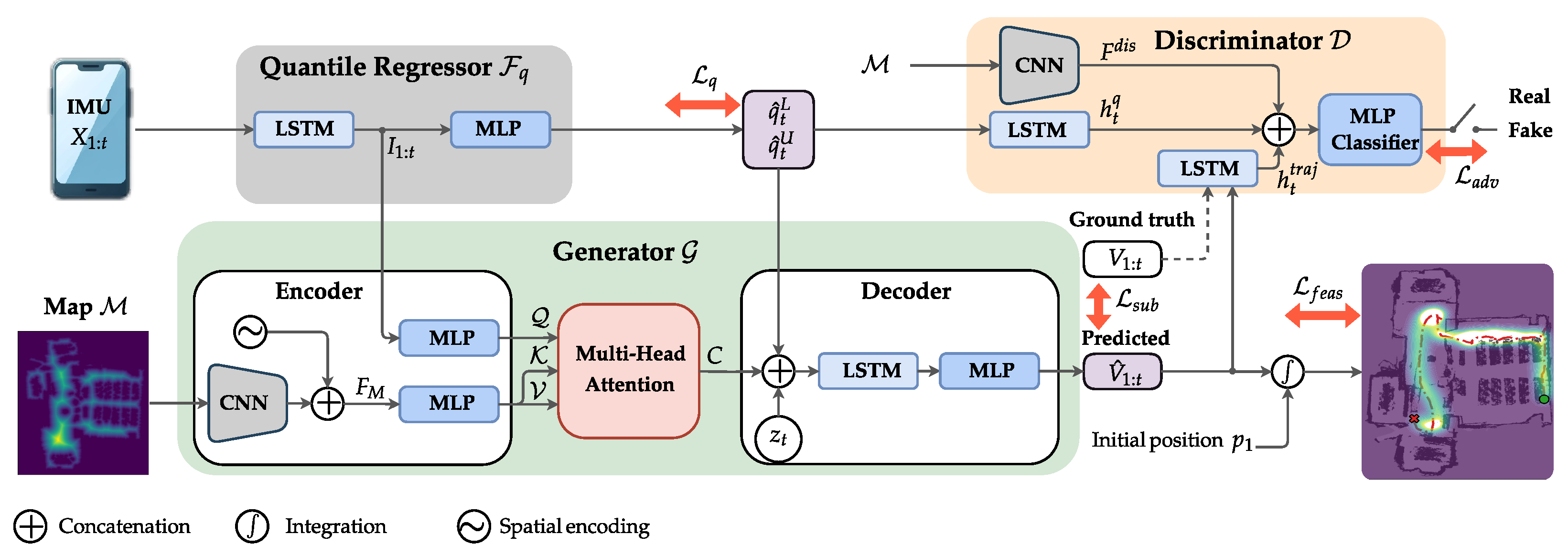
UMLoc is a two-stage framework that (1) estimates predictive uncertainty bounds using an LSTM-based quantile regression module and (2) generates spatially feasible velocity trajectories via a CGAN conditioned on an environmental map.
Figure 1 illustrates the end-to-end pipeline of the proposed UMLoc framework.
We begin by introducing the quantile prediction module, followed by the map-constrained CGAN, which employs a cross-attention mechanism to generate trajectories consistent with both the predicted uncertainty intervals and the environmental map. We then describe the data-collection process used for training and present the progressive training curriculum designed to optimize the model end-to-end.
3.1. LSTM-Based Quantile Regression Module
Localization drift primarily stems from propagated modeling uncertainties, IMU sensor biases and variability in human motion patterns. Instead of relying on deterministic velocity estimates, as in prior work [
13,
14,
16], we employed a quantile regression approach to estimate prediction intervals, providing interpretable measures of uncertainty.
Formally, given an IMU sequence
, the quantile regression module computes the lower and upper quantiles,
and
, of the ground-truth
. It is conditioned on the initial velocity
and the IMU data
, at each time
t. To compute these quantiles, the module is trained using an adapted pinball loss. The loss extends the classic formulation [
22] by the cumulative sum of the predicted velocity quantiles to estimate positional displacement over the interval
:
where
T is the trajectory length, and
.
In inertial navigation, positions are obtained by integrating velocities; thus, the dominant failure mode is drift, where small systematic velocity errors accumulate over time. To align the training objective with this property, we apply the pinball loss to the cumulative velocity residuals. Therefore, minimizing (
4) encourages the predicted quantiles to provide calibrated bounds not only on instantaneous velocity but also on the integrated displacement, which directly governs long-horizon position error.
We stacked two layers of unidirectional LSTM layers with 64 units each to extract sequential features
. The resulting features are passed through two linear layers with shared weights of size
, producing four scalar outputs at each time step. These scalars correspond to the predicted lower and upper quantiles for the two velocity components,
and
. Together, these components constitute the quantile regressor
shown in
Figure 1. In this work, we experimented with different values of
, corresponding to
prediction intervals, respectively. The resulting interval
serves as an uncertainty-aware constraint, which conditions the trajectory generation module in the second stage of UMLoc.
3.2. Conditional Generative Adversarial Network (CGAN)
The CGAN module consists of two components: a generator network
and a discriminator network
, as illustrated in
Figure 1. The generator
learns to produce realistic velocity trajectories by sampling from the learned distribution
as in (
3). The discriminator
learns to classify real and generated velocity trajectories. The overall CGAN objective integrates an adversarial loss and a supervised estimation loss with a map feasibility penalty to jointly improve localization accuracy, spatial feasibility and drift resilience.
The generator
architecture is shown in
Figure 1 and consists of a CNN–attention encoder and an LSTM-based decoder. The encoder processes the 2D environmental map
to generate a feature map. We encode this map using a lightweight CNN consisting of two blocks (32 and 64 channels) of Convolution, batch normalization and Rectified Linear Unit (ReLU), each followed by
max-pooling. Then a depthwise
convolution and a final
pointwise convolution that projects features to the context feature dimension. Then, it is augmented by the 2D coordinates (spatial encoding) to provide spatial awareness as
.
The feature map
is reshaped into a sequence of
tokens and linearly projected by the MLP to obtain the keys and values
. In parallel, the temporal IMU features
are projected to the same attention dimension
d via an MLP to form the temporal queries
. Then, we apply multi-head cross-attention with
heads, where each head attends from the temporal queries to the spatial tokens. The head outputs are concatenated and projected to produce the fused context sequence
as follows:
where
,
,
and
are learnable projection matrices. The resulting context vector aggregates map information relevant to the current IMU state, allowing the model to selectively emphasize spatial regions (e.g., high-clearance corridors vs. near-obstacle areas) when generating the trajectory.
Overall, this design grounds the IMU sequence in the environment’s spatial context while enforcing feasibility constraints that prevent information leakage from invalid areas. To introduce controlled stochasticity and enhance diversity, the cross-attention context vector
at time step
t is concatenated with latent Gaussian noise
∼
. At each step, we form the decoder input by concatenating the cross-attention context
, the latent Gaussian noise and embedded uncertainty bounds
. The decoder is a recurrent predictor parametrized by
comprising a single-layer LSTM with 64 units. The LSTM hidden state is then mapped through a linear layer to generate the velocity estimate
conditioned on the predicted quantiles
and cross-attention context vector, ensuring that the generated trajectories remain within the learned quantile-based uncertainty bounds as follows:
Thus, the positions follow discrete integration: , where is the sampling period which corresponds to in our experiments.
To differentiate between real velocity trajectory
and generated trajectory
, the discriminator
is conditioned on
. We used 2 LSTM encoders with 32 units to process the trajectory and the corresponding quantile bounds, respectively, and use their final hidden states, denoted by
and
. In addition, a CNN extracts a feature vector
from the 2D map
. The MLP classifier then takes the concatenation of these features and hidden states to distinguish between real and generated velocity trajectories.
where
denotes the discriminator’s predicted label, indicating whether the selected trajectory sample corresponds to a ground truth (real) or generated (fake) data.
Empirically, adding
to
reduced stability and did not improve the framework’s performance. The discriminator
is trained to minimize the following adversarial loss
:
We train the generator to encourage the production of trajectories with low final displacement error (FDE). Specifically, we generate
samples and select the trajectory with the lowest FDE. The generator
is optimized with a composite weighted objective that combines adversarial loss and a supervised velocity and position loss with a map feasibility penalty,
, where
Here, penalizes trajectories that are close to or intersect with obstacles in the map. This penalty uses a safety margin, , which is applied when the trajectories are within distance of any obstacles. is chosen empirically to be . The supervised loss enforces supervision, with chosen to balance the velocity and position contribution. The weights are empirically chosen to balance each learning task and stabilize training, with and linearly ramped over training iterations i to gradually enforce spatial feasibility .
3.3. Data Preparation for Training and Evaluation
Each data sample comprises 6-DoF IMU readings collected from an Android smartphone (Samsung Galaxy S23 Ultra, Vietnam) placed in the pedestrian’s pants pocket. It consists of 3-axis linear accelerations and 3-axis angular velocities, in addition to ground-truth position data and a 2D map generated using the SLAM API of the Stereolabs (Paris, France) ZED 2i camera system, which is fixed to the pedestrian’s chest. The IMU measurements are reported in the device body frame
, which changes dynamically as the device moves. In contrast, both the ground-truth positions and the 2D map are represented in a fixed global frame
. It is defined by a right-handed
z-up coordinate system with the
z-axis aligned with the gravity. Hence, the Android Game Rotation Vector (GRV) [
23] is used to estimate the smartphone’s orientation
in quaternion form. It is then applied to transform the IMU measurement
from the body frame
to the global frame
:
where
denotes the quaternion conjugate of
.
During training, both IMU data and ground-truth velocities are randomly rotated by an angle
on the horizontal plane [
14]. This augmentation compels the model to learn heading-invariant motion patterns such as steps, turns and lateral movements. As a result, the trajectory direction naturally emerges from successive velocity predictions, leading to better generalization at inference. During testing, the GRV is used to estimate the smartphone’s orientation to ensure that the
z-axis of the output frame remains aligned with gravity.
In addition, a 2D map is constructed as a binary occupancy grid , where static structures such as walls, doors and offices are represented as obstacles. Hence, takes the value 1 if cell is free and 0 otherwise. To enable differentiability and capture rich spatial context, a Euclidean distance transform is applied to the occupancy grid, producing a smoothed representation. In , each cell stores the shortest Euclidean distance to the nearest obstacle.
The resulting distance values are converted to metric units using the map resolution r (in meters per pixel), yielding the final map representation . This continuous map-aware encoding promotes numerical stability, embeds spatial proximity to obstacles and supports gradient-based learning.
3.4. Training Process
We adopted a curriculum-based learning strategy to meet our objectives of predictive bounds, feasible trajectory generation and reduced drift in inertial localization. The training is conducted in three successive phases to stabilize adversarial learning and propagate uncertainty from quantile bounds into the map-conditioned generator.
First, the quantile module was pretrained for 150 epochs by minimizing . Next, CGAN was trained for 50,000 iterations to generate global velocity sequences, while optimizing with the quantile module frozen, starting with a warm-up supervised learning to minimize . After that, we annealed the adversarial term to shape realistic and multimodal motion once predictions were reasonable. Then, we ramped the feasibility loss to enforce map compliance. Finally, both modules were fine-tuned jointly in an end-to-end manner.
We implemented the proposed model using PyTorch
and ran it on an NVIDIA RTX 2080 Ti GPU (12 GB). In this work, we tuned the hyperparameters using optuna [
24] for hyperparameter optimization. For training, the Adam optimizer was used, with learning rates of
for the quantile module, generator and discriminator, respectively. We used the two-time-scale update rule [
25], training the discriminator with a larger learning rate and multiple updates per generator step, which empirically stabilizes CGAN training and improves convergence. A batch size of 16 and a window of size 120, corresponding to
, is employed to train the proposed model. A scheduler is used to adjust the learning rate of the quantile module, reducing it by a factor of
if the validation loss does not decrease for 15 epochs.
The end-to-end model required approximately 14 h of training. Regarding the inference time, UMLoc requires an average of per full trajectory. For streaming operations, the average latency is per prediction window, using CGAN samples per instance. It corresponds to an effective inference rate of approximately 200 Hz, which supports real-time deployment at 60–100 Hz (i.e., – budget per step), providing a –× computational margin, given access to the 2D map.
5. Conclusions
In this paper, we propose UMLoc, a novel localization framework that integrates an LSTM-based quantile-regression module with a map-conditioned CGAN to reduce drift and provide explicit prediction intervals. Through comprehensive experiments across our dataset and benchmark datasets, UMLoc consistently outperforms state-of-the-art approaches. The results demonstrate substantial improvements in accuracy, robustness and generalization capabilities. This work opens new avenues for researchers to explore more sophisticated integration techniques, extend the concept to various sensor modalities and address real-world localization challenges.
Future research directions include extending UMLoc to three-dimensional localization and addressing deployment challenges in real-world indoor navigation (i.e., shopping malls, airports, office buildings, hospitals and industrial facilities) and robotic applications.