MURM-A*: An Improved A* Within Comprehensive Path-Planning Scheme for Cellular-Connected Multi-UAVs Based on Radio Map and Complex Network

Abstract
1. Introduction
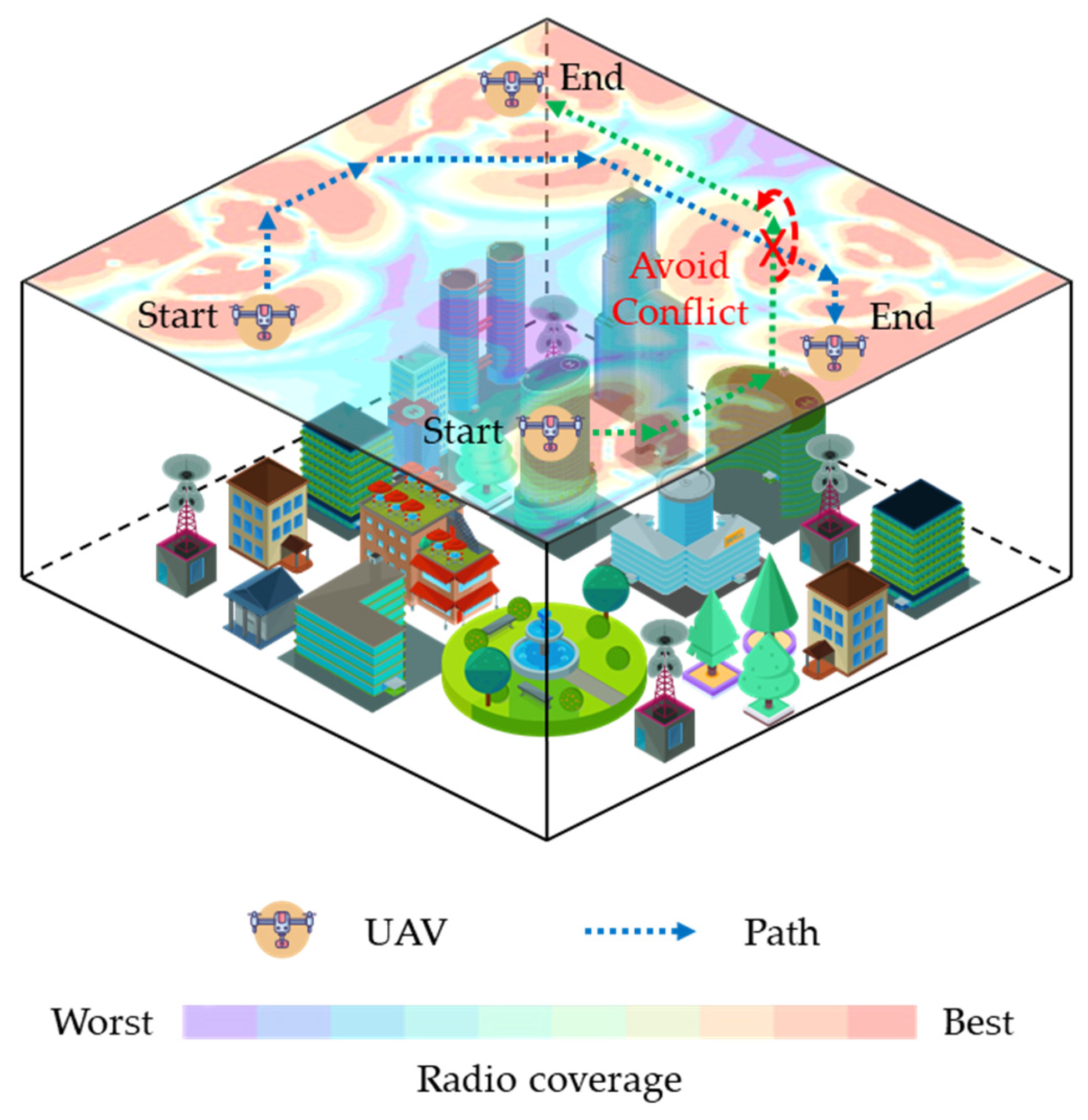
- Construction of an integrated path-planning model: Based on the environmental map and radio map from the specific scenario, we construct an innovative path-planning model using a complex network. This model provides algorithms with a clean, environment map-agnostic representation, featuring extensibility and short construction time. In simulations, the model construction time was substantially reduced compared to a DRL approach (approximately 2 s vs. 60 h).
- Proposal of MURM-A* algorithm: Building on the path-planning model and traditional A*, we propose MURM-A*. By incorporating directional, obstacle, and multi-UAV conflict constraints into an optimized node expansion strategy, the algorithm plans optimal paths that strictly adhere to all specified constraints. Simulation results demonstrate the achievement of 0 obstacle collisions, 0 excessive turning angles, and 0 multi-UAV conflicts.
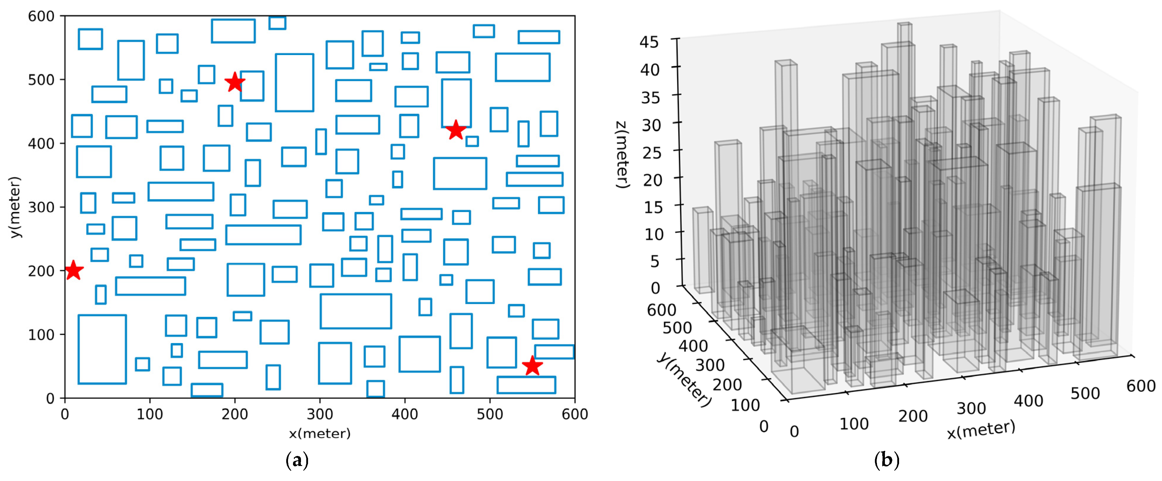
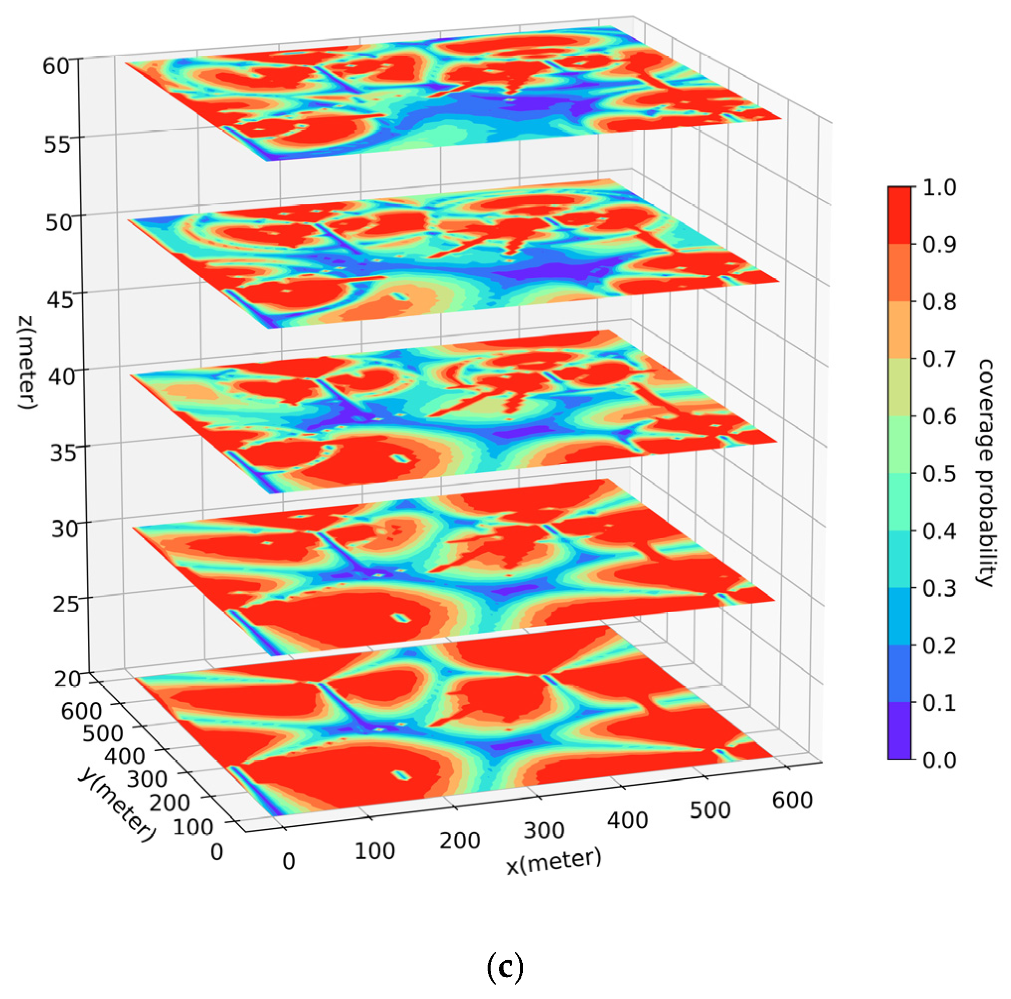
- Comprehensive Simulation Verification: We designed comparative simulation experiments within a generated 3D dense urban model along with a corresponding radio map. The results indicate that compared to the DRL approach, the proposed scheme marginally increased the flight time (around 6%) while significantly reducing the outage duration (around 43%). The results validate the effectiveness and superiority of the proposed algorithm within the path-planning model under multiple constraints.
2. Related Work
2.1. Cellular-Connected UAV Path Planning
2.2. Multi-UAV Path Planning
2.3. Common Issues
- Narrow Optimization Objectives: The existing path-planning schemes often consider only the single factor of minimizing the path length from start to end. Consequently, performance comparison experiments focus predominantly on the path length metric, neglecting to integrate critical constraints such as network coverage, obstacle avoidance, and UAV flight dynamics.
- Unrealistic Simulation Environments: The simulated environments are frequently simplistic, featuring building layouts that are either overly regular or excessively sparse, resulting in a significant discrepancy from real-world conditions.
- Oversimplified Action and Cost Modeling: The partitioning of the action space is frequently too crude, and the assignment of weights to paths relies excessively on idealized states. This approach lacks integration with real-world environmental factors, causing the model formulation to deviate from the actual research problem.
- Neglect of the Path-Planning Model: Research commonly lacks in-depth discussion of the path-planning model itself. The primary focus on proposing a new algorithm leads to the neglect of rigorous processing of environmental map data. Algorithms are typically designed for and directly applied to a given map, or permitted to alter map data. This blurs the responsibility boundary between the algorithm and the map, creating the illusion that traditional or improved algorithms can interfere with the map.
- Over-Reliance on Specific Map: A common technical bottleneck is that the algorithms excessively rely on a single, specific map that must conveniently supply all required data in the correct format. Such an approach overlooks practical scenarios where multiple map sources exist and the data they provide may not directly meet the requirement. Consequently, algorithms may fail to accurately interpret environmental information in real-world settings, limiting their extensibility.
3. Problem Formulation
3.1. Radio Map Model
3.2. Problem Definition
- (1)
- Minimize the total travel time T;
- (2)
- Minimize the likelihood of communication interruptions, as reflected by the outage probability
4. Methodology
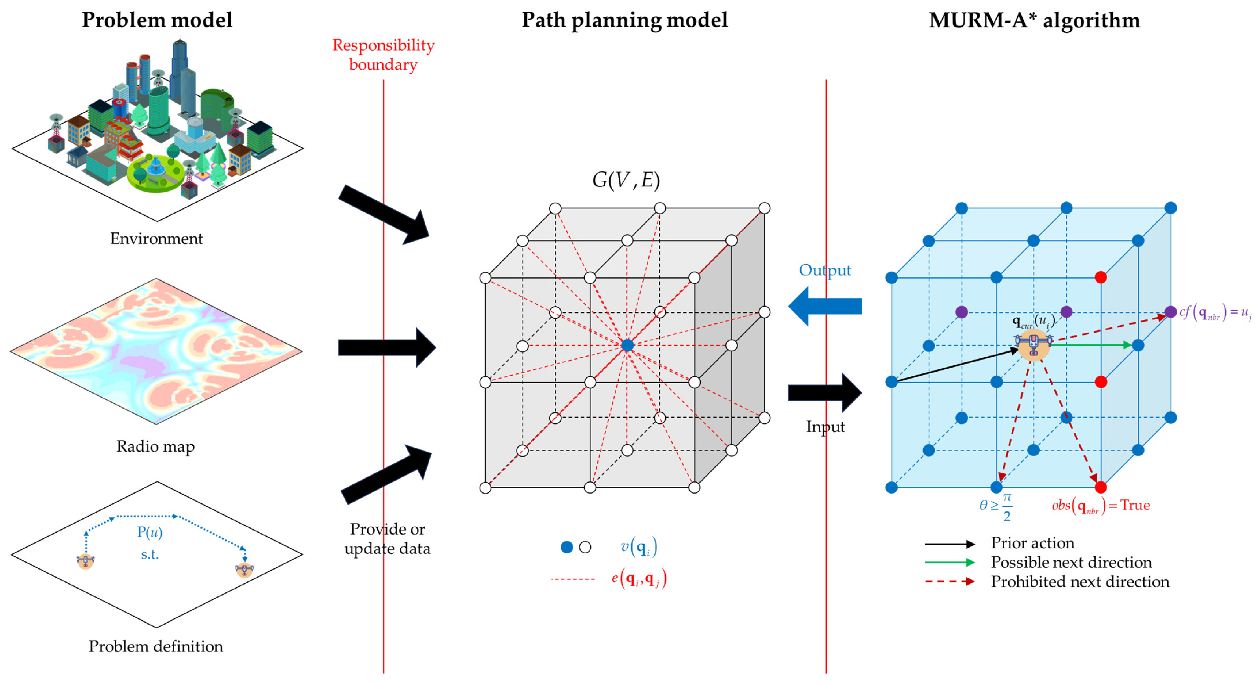
4.1. Comprehensive Scheme Architecture
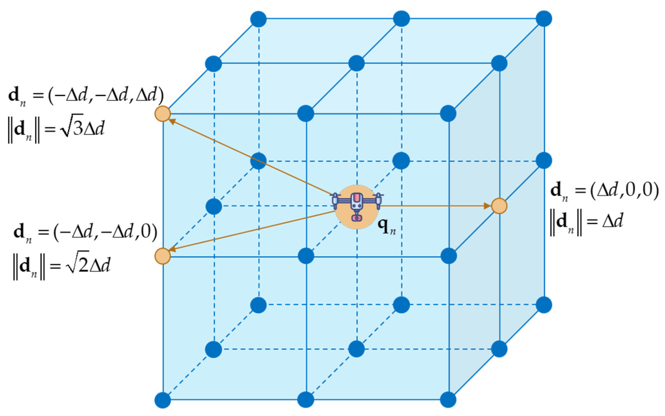
4.2. Path-Planning Model
4.3. MURM-A* Algorithm
- (1)
- Obstacle Avoidance
- (2)
- UAV maneuverability Constraints
- (3)
- Multi-UAV Path Conflict Constraints
| Algorithm 1. MURM-A* |
| Input: Navigation model G, starting point , destination point . |
| Begin |
| Calculate based on Formula (11), , . |
| OPEN.push([, , , ]) |
| While |
| If // The destination is reached. |
| Return |
| End If |
| If |
| If or |
| Continue // Avoid overriding of parent of starting node or visiting bad path. |
| End if |
| Else |
| CLOSE.add() |
| End if |
| // Set the parent node. |
| For each neighbor node of // Expand nodes. |
| If |
| Continue // Skip the node in the obstacle. |
| End if |
| If or |
| Continue // Skip the node if the path conflicts with other UAVs. |
| End if |
| Calculate turning angle based on Formulas (12)–(14). |
| If |
| Continue // Skip the node when the turning angle is excessive. |
| End if |
| Calculate based on Formula (11). |
| If has been set and |
| Continue // Skip the node when a more optimal path to it is already found. |
| End if |
| Set , calculate and update , . |
| OPEN.push([, , , ]) |
| End for |
| End while |
| Return // Indicating that no path is found. |
| Output: Return result (Path set or ) |
4.4. Systematic Analysis
4.4.1. Extensibility Analysis
- (a)
- Direct application of algorithms to environmental maps creates a dependency on specific map formats and precision levels. In practice, environmental data often originates from multiple maps whose precision may not align with the granularity required for path planning, and the information they provide is not always directly usable by algorithms. Even minor variations in map format, precision, or semantics can render algorithms incapable of interpreting the data or retrieving necessary information from alternative maps, leading to a significant degradation in performance. In contrast, the proposed path-planning model extracts and transforms relevant information from various maps into a problem-specific representation. This approach eliminates the need for strict adherence to original map data formats and precision, better preserves the integrity of map data, and provides algorithms with a more robust environment for pathfinding.
- (b)
- Real-world environmental maps are not necessarily static; factors within the environment may change, resulting in different environmental states. The path-planning model is grounded in graph theory and does not rely on memorizing specific states. Instead, it depends on an explicit, structured representation of spatial topology and optimization objectives. Consequently, when confronted with changes in environmental conditions, the model itself does not require reconstruction, nor do the core algorithms need modification. Simply updating the model data (e.g., attributes of nodes/edges) enables the algorithms to adapt swiftly to the new state.
4.4.2. Applicability Analysis
- Input: Environmental map, Radio map
- (1)
- Construct a graph
- (2)
- According to the problem model, for each position , add a node to V. Obtain the value from the radio map and store it in the “outage” attribute of . Determine whether lies within a building area from the environmental map using a custom-defined rule, and set the “obstacle” attribute based on the result. Initialize
- (3)
- Following the action set , add all directed edge to E, where the cost value is computed by Formula (9). Initialize
- Output: Path-planning model
- (1)
- Prior to mission start, a UAV submit a request (containing the algorithmic input) and enter the path planning request queue.
- (2)
- Following the queue order, the pathfinding process for each UAV is handled according to the MURM-A* algorithm workflow shown in Table 2.
- (3)
- Once a path is obtained, the UAV u commences the mission and notifies the path-planning model to mark the occupancy according to Equation (16). If no path is found, the UAV enters a waiting state and re-enter the request queue.
- (4)
- After UAV u reaches its destination, it notifies the path-planning model to release the occupancy.
4.4.3. Sensitivity Analysis
- (1)
- Environmental Map and Radio Map: The problem generally requires the granularity of the environmental map and the radio map to be of the form (the environmental map may be continuous). The sampling scale for constructing the radio map tends to grow approximately as , thereby raising the measurement and computational costs of sampling.
- (2)
- Path Planning Model: The computational effort required for modeling increases roughly as
- (3)
- Pathfinding Algorithm: As the search space expands, the computational growth does not exceed (the worst case approximates ). Furthermore, excess route refinement may lead to overly frequent turning by the UAV.
- (4)
- Amount of UAVs: Owing to the sequential nature of the planning process, when the number of UAVs increases, the overall path-planning complexity in the worst case can grow approximately as . An excessive number of UAVs may also cause UAVs with lower priority to frequently fail in finding a path or experience a sharp degradation in path quality.
- (a)
- Determine reasonably based on factors such as UAV maneuverability, the scale of the UAV fleet, environmental map precision, and available computational resources, while ensuring the equivalence relationship described in Section 3.2 holds.
- (b)
- Sample and generate the radio map according to the precision defined by . Construct the path-planning model with the granularity of
4.4.4. Limitations Analysis
- (a)
- Static Scenario and Discrete Space: The comprehensive scheme primarily performs planning in a static discrete space based on a radio map and a known environment. This requires the radio environment to remain quasi-static over a sufficiently long period, where the radio map errors are confined to small-scale fading. Furthermore, the current formulation for deployment does not account for dynamic elements such as emergent obstacles, temporary no-fly zones, or time-varying radio conditions, and the A* algorithm still faces considerable challenges in dynamic path planning.
- (b)
- Constant Velocity and Neglected Energy Consumption: The scheme assumes UAVs fly at a constant speed and does not explicitly account for energy consumption. In practical deployment, it may be difficult for a UAV to follow a strictly constant speed due to motion inertia, and the obtained optimal path does not guarantee minimal energy expenditure.
- (c)
- Low Level of Cooperation: The scheme primarily targets priority-based, independent task path-planning scenarios. When an excessive number of UAVs submit simultaneous requests or when tasks require tight cooperation, sequential planning may reduce global solution efficiency, and the quality of the global solution depends heavily on the priority ordering.
- (d)
- Stringent Constraint Mechanism: To guarantee absolute safety and feasibility, the scheme completely avoids obstacles, prevents excessively sharp turns, and resolves multi-UAV conflicts by restricting node expansion during pathfinding. However, this approach presupposes that both the scenario setup and the granularity selection () are reasonable. This makes the practice deployment should carefully configure the scenario and problem requirements. Otherwise, low-priority UAVs may frequently fail to find a feasible path. Regardless, it is acknowledged that in practical applications, prioritizing UAV safety is often a more common and critical concern than guaranteeing a feasible path always exists from the perspective of the algorithm.
5. Evaluation
5.1. Evaluation Setup
- (1)
- MURM-A*. The improved A*-based algorithm proposed in this paper, with the principle described in Section 4.3. It will perform pathfinding based on the path-planning model.
- (2)
- PPM-A*. The traditional A* algorithm is incorporated into the path-planning model from Section 4.2 for pathfinding.
- (3)
- EM-A*. The benchmark method is the choice adopted by most of the research. It represents the theoretically optimal solution when traditional A* or MURM-A* performs pathfinding in the environmental map rather than in the path-planning model.
- (4)
- D3QN. A state-of-the-art algorithm in the field of DRL [52]. It employs a Markov Decision Process for exploratory training in discrete space, and its training reward mechanism is similar in form to the objective of this research problem. It is designed only for a single UAV.
- (5)
- SURM-A*. Compared to MURM-A*, it only considers the constraints of the single UAV itself.
5.2. Evaluation Result
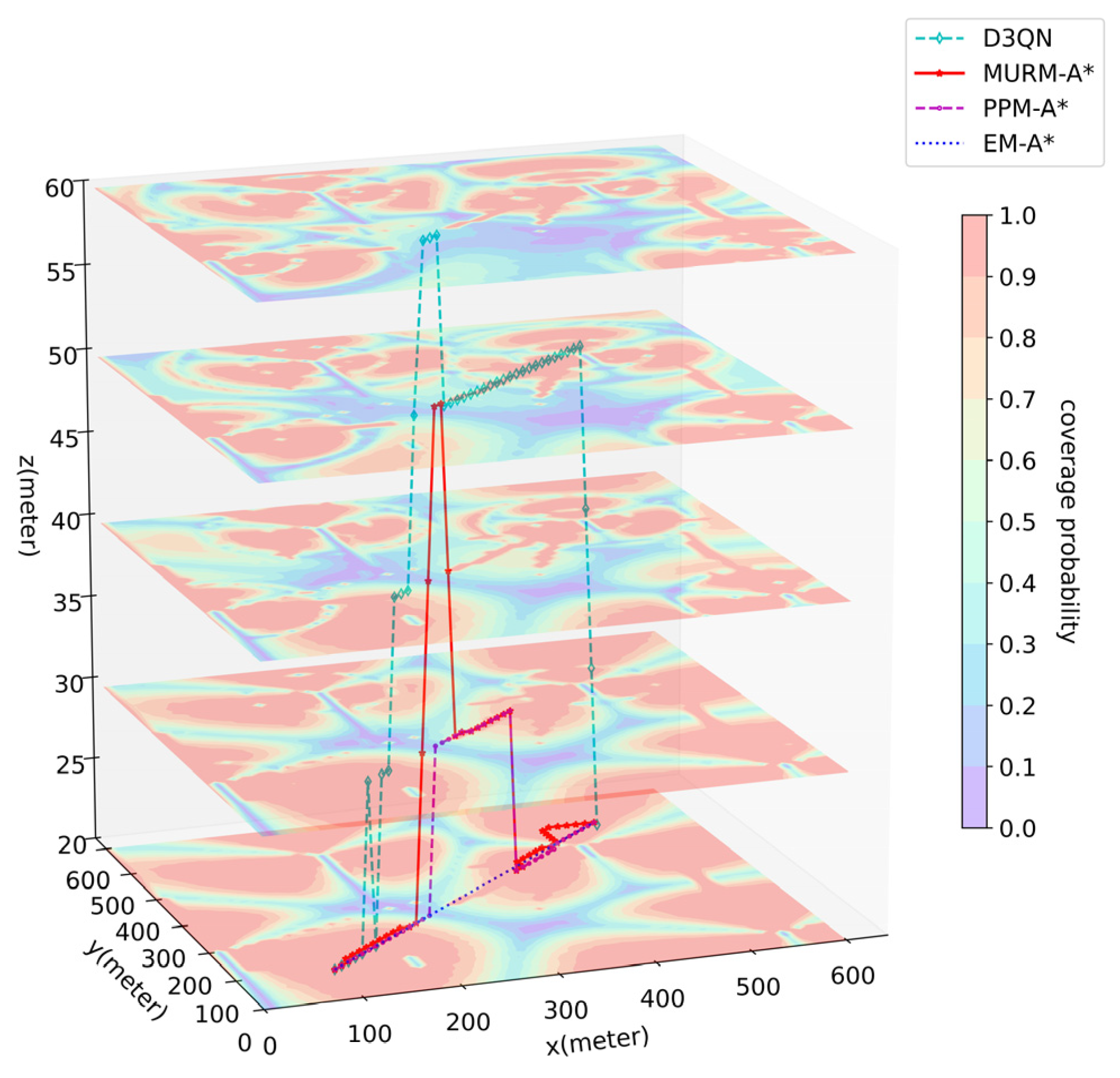
- EM-A* disregards environmental and communication constraints, plans the geometrically shortest path (flight time 56.56 s), while exhibiting a high outage duration (average 6.67 s) and a large number of collisions (average 8 times).
- PPM-A* validates the effectiveness of the path-planning model in incorporating communication constraints. Nevertheless, due to the lack of a constraint-handling mechanism, it results in an average of 6.20 obstacle collisions and 0.65 excessive turns.
- D3QN feasibly achieves the shortest flight time (average 59.42 s) but incurs the longest radio outage (average 8.90 s). Moreover, the model training (approximately 60 h) and pathfinding time (average 239.65 s) substantially exceed those of the other methods.
- MURM-A* guarantees 0 obstacle collisions and 0 excessive turns. Compared with D3QN, it increases flight time (around 6%) while reducing outage duration (around 43%). The modeling time remains extremely short (around 2 s).
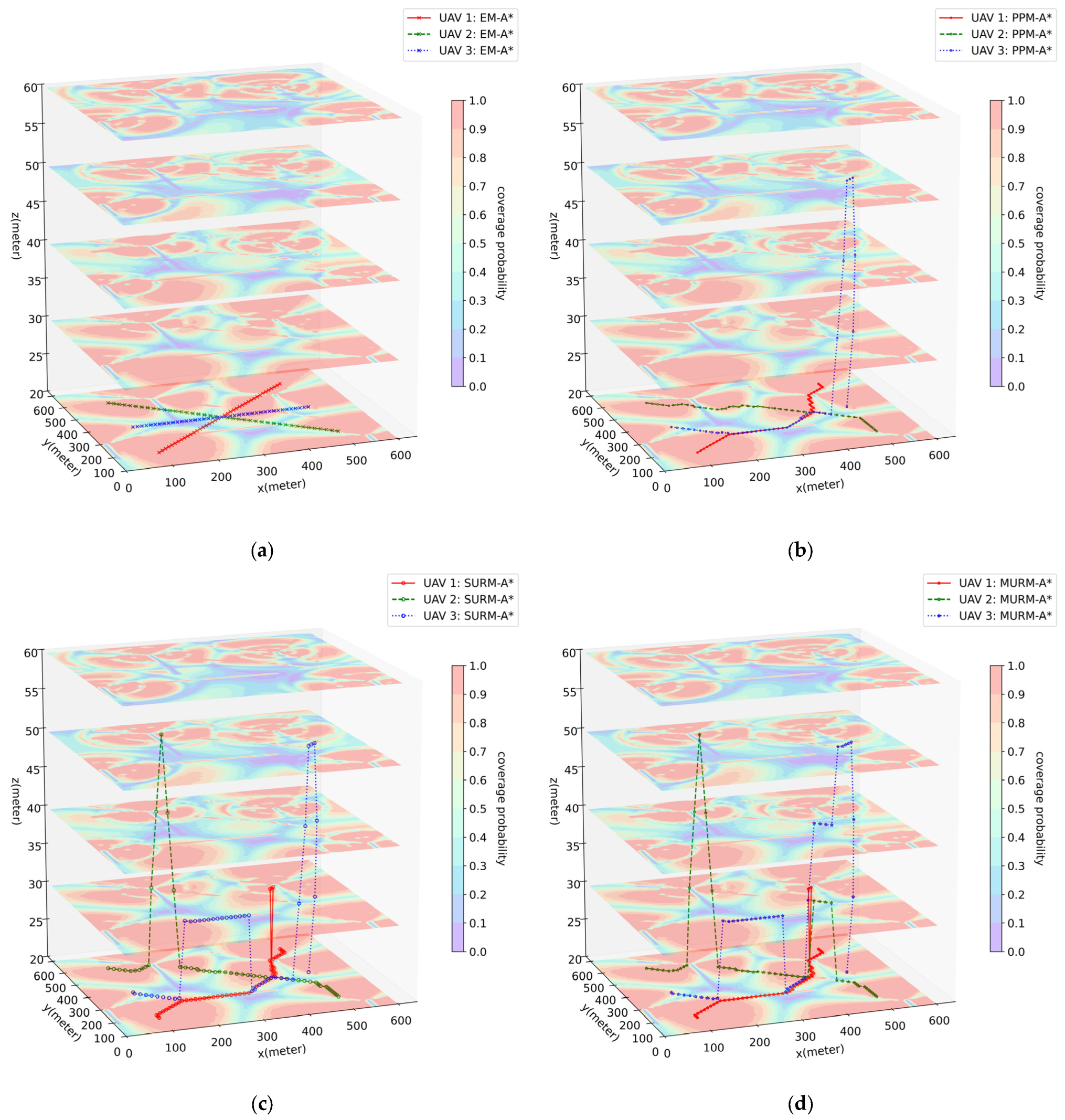
- EM-A* again produces the shortest flight times, yet outage durations are considerably higher (especially for UAV 2 and UAV 3, averaging 15.62 s and 17.64 s, respectively).
- PPM-A* shows improved outage performance, yet frequent obstacle collisions (average 5.49 times) and severe path conflicts (average 10.16 times) persist.
- SURM-A* inherits the communication performance of PPM-A* while achieving 0 collisions and 0 excessive turns. However, it still suffers from a high number of path conflicts (average 7.88 times).
- MURM-A* maintains 0 collisions and 0 excessive turns, reduces path conflicts to 0, and achieves outage durations comparable to those of SURM-A*.
- Model construction times for all algorithms remain on the order of seconds (about 2 s). Due to the additional constraints, MURM-A* exhibits a slight increase in pathfinding time, which is still confined to the millisecond range.
6. Conclusions
- Real-time Replanning in Dynamic Environments: Leveraging the adaptable nature of the path-planning model, future work could focus on incorporating real-time sensor data to dynamically update node/edge attributes, introducing a temporal dimension into occupancy representations, and designing incremental replanning algorithms (e.g., D* Lite) with low computational complexity. This would enable UAVs to respond online to environmental changes and adjust their paths in real time.
- Integrated Optimization Considering Energy Consumption: A viable approach involves assigning energy cost attributes to all edges based on a kinematic analysis of motion in different directions. However, establishing a precise and universally applicable energy consumption model is challenging due to variations in UAV maneuverability and environmental conditions. Integrating such a model as a key constraint or optimization objective into the existing complex-network-based planning framework remains a complex challenge.
- Multi-UAV Cooperative Path Planning for Collaborative Tasks: Advancing the path-planning model for cooperative scenarios typically requires redefining nodes from single-agent states to partial or global joint states. Algorithms would then need to evolve beyond mere conflict prevention. They must actively account for the spatiotemporal coupling of UAV trajectories, develop cooperative strategies for task allocation, and optimize communication network topology to achieve true swarm intelligence and maximize collaborative efficiency.
Author Contributions
Funding
Institutional Review Board Statement
Informed Consent Statement
Data Availability Statement
Conflicts of Interest
References
- Zeng, Y.; Lyu, J.; Zhang, R. Cellular-Connected UAV: Potential, Challenges, and Promising Technologies. IEEE Wirel. Commun. 2019, 26, 120–127. [Google Scholar]
- An, S.; Yu, R. Review on Complex Network Theory Research. Comput. Syst. Appl. 2020, 29, 26–31. [Google Scholar]
- Cai, Y.; Zhang, E.; Qi, Y.; Lu, L. A Review of Research on the Application of Deep Reinforcement Learning in Unmanned Aerial Vehicle Resource Allocation and Trajectory Planning. In Proceedings of the 2022 4th International Conference on Machine Learning, Big Data and Business Intelligence (MLBDBI), Shanghai, China, 28–30 October 2022; pp. 238–241. [Google Scholar]
- Li, K.; Ni, W.; Tovar, E.; Guizani, M. Deep Reinforcement Learning for Real-Time Trajectory Planning in UAV Networks. In Proceedings of the 2020 International Wireless Communications and Mobile Computing (IWCMC), Limassol, Cyprus, 15–19 June 2020; pp. 958–963. [Google Scholar]
- Betalo, M.L.; Leng, S.; Abishu, H.N.; Seid, A.M.; Fakirah, M.; Erbad, A.; Guizani, M. Multi-Agent DRL-Based Energy Harvesting for Freshness of Data in UAV-Assisted Wireless Sensor Networks. IEEE Trans. Netw. Serv. Manag. 2024, 21, 6527–6541. [Google Scholar] [CrossRef]
- Betalo, M.L.; Leng, S.; Mohammed Seid, A.; Nahom Abishu, H.; Erbad, A.; Bai, X. Dynamic Charging and Path Planning for UAV-Powered Rechargeable WSNs Using Multi-Agent Deep Reinforcement Learning. IEEE Trans. Autom. Sci. Eng. 2025, 22, 15610–15626. [Google Scholar] [CrossRef]
- Chen, D.; Wen, J.; Xi, M.; Xiao, S.; Yang, J. Unmanned Aerial Vehicle Path Planning Based on Improved DDQN Algorithm. In Proceedings of the 2024 IEEE International Symposium on Broadband Multimedia Systems and Broadcasting (BMSB), Toronto, ON, Canada, 19–21 June 2024; pp. 1–6. [Google Scholar]
- Kong, F.; Wang, Q.; Gao, S.; Yu, H. B-APFDQN: A UAV Path Planning Algorithm Based on Deep Q-Network and Artificial Potential Field. IEEE Access 2023, 11, 44051–44064. [Google Scholar] [CrossRef]
- Bulut, E.; Guevenc, I. Trajectory Optimization for Cellular-Connected UAVs with Disconnectivity Constraint. In Proceedings of the 2018 IEEE International Conference on Communications Workshops (ICC Workshops), Kansas City, MO, USA, 20–24 May 2018; pp. 1–6. [Google Scholar]
- Challita, U.; Ferdowsi, A.; Chen, M.; Saad, W. Machine Learning for Wireless Connectivity and Security of Cellular-Connected UAVs. IEEE Wirel. Commun. 2019, 26, 28–35. [Google Scholar] [CrossRef]
- Esrafilian, O.; Gangula, R.; Gesbert, D. 3D-Map Assisted UAV Trajectory Design Under Cellular Connectivity Constraints. In Proceedings of the ICC 2020—2020 IEEE International Conference on Communications (ICC), Dublin, Ireland, 7–11 June 2020; pp. 1–6. [Google Scholar]
- Lee, W.; Jeon, Y.; Kim, T.; Kim, Y.-I. Deep Reinforcement Learning for UAV Trajectory Design Considering Mobile Ground Users. Sensors 2021, 21, 8239. [Google Scholar] [CrossRef]
- Zeng, Y.; Xu, X.; Jin, S.; Zhang, R. Simultaneous Navigation and Radio Mapping for Cellular-Connected UAV with Deep Reinforcement Learning. IEEE Trans. Wirel. Commun. 2021, 20, 4205–4220. [Google Scholar] [CrossRef]
- Hao, Q.; Huang, H.; Zhao, H.; Tan, Y.; Zhu, C. Online Path Planning of Cellular-Connected UAVs Based on Radio Map Reconstruction. Mob. Commun. 2023, 47, 8–14. [Google Scholar]
- Liu, X.; Zhong, W.; Wang, X.; Duan, H.; Fan, Z.; Jin, H.; Huang, Y.; Lin, Z. Deep Reinforcement Learning-Based 3D Trajectory Planning for Cellular Connected UAV. Drones 2024, 8, 199. [Google Scholar] [CrossRef]
- Liu, X.; Zhou, L.; Zhang, X.; Tan, X.; Wei, J. A 3D REM-Guided UAV Path Planning Method under Communication Connectivity Constraints. Wirel. Commun. Mob. Comput. 2022, 2022, 7410708. [Google Scholar] [CrossRef]
- He, Z.; Zhao, L. The Comparison of Four UAV Path Planning Algorithms Based on Geometry Search Algorithm. In Proceedings of the 2017 9th International Conference on Intelligent Human-Machine Systems and Cybernetics (IHMSC), Hangzhou, China, 26–27 August 2017; Volume 2, pp. 33–36. [Google Scholar]
- Zammit, C.; Van Kampen, E.J. Comparison Between A* and RRT Algorithms for 3D UAV Path Planning. Unmanned Syst. 2022, 10, 129–146. [Google Scholar] [CrossRef]
- Ju, C.; Luo, Q.; Yan, X. Path Planning Using an Improved A-Star Algorithm. In Proceedings of the 2020 11th International Conference on Prognostics and System Health Management (PHM-2020), Jinan, China, 23–25 October 2020; pp. 23–26. [Google Scholar]
- Chen, F.; Xu, X. Three-Dimensional Path Planning of UAV Based on Improved A* Algorithm. In Proceedings of the 2025 7th International Conference on Information Science, Electrical and Automation Engineering (ISEAE), Harbin, China, 18–20 April 2025; pp. 1337–1341. [Google Scholar]
- Zhang, W.; Li, J.; Yu, W.; Ding, P.; Wang, J.; Zhang, X. Algorithm for UAV Path Planning in High Obstacle Density Environments: RFA-Star. Front. Plant Sci. 2024, 15, 1391628. [Google Scholar] [CrossRef] [PubMed]
- Bai, X.; Jiang, H.; Cui, J.; Lu, K.; Chen, P.; Zhang, M. UAV Path Planning Based on Improved A∗ and DWA Algorithms. Int. J. Aerosp. Eng. 2021, 2021, 4511252. [Google Scholar] [CrossRef]
- Liu, B.; Lyu, Y. A 3D UAV Path Planning Model Based on Improved A* Algorithm and DEM Data. J. Phys. Conf. Ser. 2023, 2580, 012043. [Google Scholar] [CrossRef]
- Gu, Z.; Liu, Y.; Sun, W.; Yue, G.; Sun, S. UAV Dynamic Route Planning Algorithm Based on RRT. Comput. Sci. 2023, 50, 65–69. [Google Scholar]
- Zhao, Y.; Liu, K.; Lu, G.; Hu, Y.; Yuan, S. Path Planning of UAV Delivery Based on Improved APF-RRT* Algorithm. J. Phys. Conf. Ser. 2020, 1624, 042004. [Google Scholar] [CrossRef]
- Guo, Y.; Liu, X.; Liu, X.; Yang, Y.; Zhang, W. FC-RRT*: An Improved Path Planning Algorithm for UAV in 3D Complex Environment. ISPRS Int. J. Geo-Inf. 2022, 11, 112. [Google Scholar] [CrossRef]
- Zheng, Y.; Li, A.; Chen, Z.; Wang, Y.; Yang, X.; Im, S.-K. MPN-RRT*: A New Method in 3D Urban Path Planning for UAV Integrating Deep Learning and Sampling Optimization. Sensors 2025, 25, 4142. [Google Scholar] [CrossRef]
- Konatowski, S.; Pawłowski, P. Ant Colony Optimization Algorithm for UAV Path Planning. In Proceedings of the 2018 14th International Conference on Advanced Trends in Radioelectronics, Telecommunications and Computer Engineering (TCSET), Lviv-Slavske, Ukraine, 20–24 February 2018; pp. 177–182. [Google Scholar]
- Guan, Y.; Gao, M.; Bai, Y. Double-Ant Colony Based UAV Path Planning Algorithm. In Proceedings of the 2019 11th International Conference on Machine Learning and Computing (ICMLC), Zhuhai, China, 22–24 February 2019; pp. 258–262. [Google Scholar]
- Zhang, S.; Zeng, Y.; Zhang, R. Cellular-Enabled UAV Communication: A Connectivity-Constrained Trajectory Optimization Perspective. IEEE Trans. Commun. 2019, 67, 2580–2604. [Google Scholar] [CrossRef]
- Yang, D.; Dan, Q.; Xiao, L.; Liu, C.; Cuthbert, L. An Efficient Trajectory Planning for Cellular-Connected UAV under the Connectivity Constraint. China Commun. 2021, 18, 136–151. [Google Scholar] [CrossRef]
- Chen, Y.; Yang, D.; Xiao, L.; Wu, F.; Xu, Y. Optimal Trajectory Design for Unmanned Aerial Vehicle Cargo Pickup and Delivery System Based on Radio Map. IEEE Trans. Veh. Technol. 2024, 73, 11706–11718. [Google Scholar] [CrossRef]
- Carrese, S.; D’Andreagiovanni, F.; Nardin, A.; Giacchetti, T.; Zamberlan, L. Seek & Beautify: Integrating UAVs in the Optimal Beautification of e-Scooter Sharing Fleets. In Proceedings of the 2021 7th International Conference on Models and Technologies for Intelligent Transportation Systems (MT-ITS), Heraklion, Greece, 16–17 June 2021; pp. 1–6. [Google Scholar]
- Chu, H.; Yi, J.; Yang, F. Chaos Particle Swarm Optimization Enhancement Algorithm for UAV Safe Path Planning. Appl. Sci. 2022, 12, 8977. [Google Scholar] [CrossRef]
- Sharon, G.; Stern, R.; Felner, A.; Sturtevant, N.R. Conflict-Based Search for Optimal Multi-Agent Pathfinding. Artif. Intell. 2015, 219, 40–66. [Google Scholar] [CrossRef]
- Guo, Y.; Liu, X.; Jiang, W.; Zhang, W. Collision-Free 4D Dynamic Path Planning for Multiple UAVs Based on Dynamic Priority RRT* and Artificial Potential Field. Drones 2023, 7, 180. [Google Scholar] [CrossRef]
- Lin, J.; Ye, F.; Yu, Q.; Xing, J.; Quan, Z.; Sheng, C. Research on Multi-UAVs Route Planning Based on the Integration of Improved Elastic Band and A-Star Algorithm. In Proceedings of the 2022 IEEE International Conference on Unmanned Systems (ICUS), Guangzhou, China, 28–30 October 2022; pp. 1575–1580. [Google Scholar]
- Du, Y. Multi-UAV Search and Rescue with Enhanced A∗ Algorithm Path Planning in 3D Environment. Int. J. Aerosp. Eng. 2023, 2023, 8614117. [Google Scholar] [CrossRef]
- Wu, W.; Li, M.; Yang, Y. Research on Multi UAV Path Planning Based on Deep Reinforcement Learning. In Proceedings of the 2025 WRC Symposium on Advanced Robotics and Automation (WRC SARA), Beijing, China, 10 August 2025; pp. 338–343. [Google Scholar]
- Westheider, J.; Rückin, J.; Popović, M. Multi-UAV Adaptive Path Planning Using Deep Reinforcement Learning. In Proceedings of the 2023 IEEE/RSJ International Conference on Intelligent Robots and Systems (IROS), Detroit, MI, USA, 1–5 October 2023; pp. 649–656. [Google Scholar]
- Chen, J.; Wang, Z.; Li, Z.; Shen, J.; Chen, P. Multi-UAV Coverage Path Planning Based on Q-Learning. IEEE Sens. J. 2025, 25, 30444–30454. [Google Scholar] [CrossRef]
- Wang, S.; Li, B.; Zhu, X.; Temuer, C. Improved A* and DWA Based Dynamic Trajectory Planning Algorithm for Multi-UAVs Formation. In Proceedings of the 2023 42nd Chinese Control Conference (CCC), Tianjin, China, 24–26 July 2023; pp. 1767–1772. [Google Scholar]
- Wang, Z.; Gong, H.; Nie, M.; Liu, X. Research on Multi-UAV Cooperative Dynamic Path Planning Algorithm Based on Conflict Search. Drones 2024, 8, 274. [Google Scholar] [CrossRef]
- Xu, Y.; Wei, Y.; Wang, D.; Jiang, K.; Deng, H. Multi-UAV Path Planning in GPS and Communication Denial Environment. Sensors 2023, 23, 2997. [Google Scholar] [CrossRef]
- Luo, Q.; Luan, T.H.; Shi, W.; Fan, P. Deep Reinforcement Learning Based Computation Offloading and Trajectory Planning for Multi-UAV Cooperative Target Search. IEEE J. Sel. Areas Commun. 2023, 41, 504–520. [Google Scholar] [CrossRef]
- Okumura, Y. Field Strength and Its Variability in VHF and UHF Land-Mobile Radio Service. Rev. Electr. Commun. Lab. 1968, 16, 825–873. [Google Scholar]
- Hata, M. Empirical Formula for Propagation Loss in Land Mobile Radio Services. IEEE Trans. Veh. Technol. 1980, 29, 317–325. [Google Scholar] [CrossRef]
- Cichon, D.J.; Kürner, T. Digital Mobile Radio Towards Future Generation Systems: Cost 231 Final Report. In European Cooperation in the Field of Scientific and Technical Research—Action 231; Technical Report; European Cooperation in Science and Technology (COST): Brussels, Belgium, 1993. [Google Scholar]
- Phillips, C.; Sicker, D.; Grunwald, D. Bounding the Error of Path Loss Models. In Proceedings of the 2011 IEEE International Symposium on Dynamic Spectrum Access Networks (DySPAN), Aachen, Germany, 3–6 May 2011; pp. 71–82. [Google Scholar]
- Hu, Y.; Zhang, R. A Spatiotemporal Approach for Secure Crowdsourced Radio Environment Map Construction. IEEE/ACM Trans. Netw. 2020, 28, 1790–1803. [Google Scholar] [CrossRef]
- Wang, X.; Wang, X.; Mao, S.; Zhang, J.; Periaswamy, S.C.G.; Patton, J. Indoor Radio Map Construction and Localization with Deep Gaussian Processes. IEEE Internet Things J. 2020, 7, 11238–11249. [Google Scholar] [CrossRef]
- Xie, H.; Yang, D.; Xiao, L.; Lyu, J. Connectivity-Aware 3D UAV Path Design with Deep Reinforcement Learning. IEEE Trans. Veh. Technol. 2021, 70, 13022–13034. [Google Scholar] [CrossRef]



| Element | Description |
|---|---|
| t | Measurement time. |
| Measurement location at time t. | |
| Connected cell, the cell where radio communication is currently conducted with the UAV at location . | |
| The small-scale fading in communication between the UAV and the cell m. Can be seen as a small random variable. | |
| The instantaneous signal power measured by the UAV from the cell m at position , containing factors of large-scale fading. |
| Comparison Dimension | Proposed Scheme | Radio-Map-Assisted DRL [13,16] | Graph-Based Multi-Agent Framework [36,43] |
|---|---|---|---|
| Map Input | Environmental map (format-agnostic), radio map | Only a single specific map integrating all information | Only a single specific map matching the format required by the algorithm |
| Static/Dynamic | Leans towards static | Either static [13] or dynamic [16] | Static planning with dynamic correction |
| Action Space | Discrete actions | Discrete [13] or continuous [16] actions (depending on DRL framework) | Discrete [43] or continuous [36] actions (depending on adopted algorithm) |
| Stored Attributes | Recognized and transformed environmental information (obstacles, radio), conflict identifiers, and costs based on problem objectives | Neuron values (e.g., Q-values) in a neural network | Hierarchical storage including cost layer, conflict resolution layer, etc. (no environmental information directly stored) |
| Planning Paradigm | Priority-based sequential planning | Determined by the DRL framework (e.g., Q-learning) | Centralized parallel planning |
| Constraint Handling | Restricts node expansion to fully adhere to constraints | Guides agents to obey constraints via a reward function | Plans without constraints initially, followed by conflict detection and explicit constraints resolution |
| Extensibility | High: No reconstruction needed for environmental changes (only attribute updates required); adaptable to more complex environments by modifying attribute structures | Low: Trained models often exhibit poor generalization, necessitating retraining when encountering environmental changes | Low: Requires reconstruction of the cost layer when environmental changes occur |
| Optimality and Feasibility | Provides an absolute-feasibility-guaranteed optimal solution for each individual agent. Does not consider global optimality. Overly restrictive constraints may lead to no solution | Typically seeks neuron-value-optimal solutions; performance depends on training quality | Typically guarantees global optimal solutions, but does not ensure feasibility under mandatory constraints, potentially rendering the global optimum invalid |
| Modeling and Pathfinding Time | Short modeling time, short pathfinding time | Extremely high training cost (long duration, large sample scale) | Short modeling time, while pathfinding time can be long due to conflict resolution mechanisms |
| Practical Deployment Suitability | Current form suitable for static/slowly changing environments with priority-based, independent task path planning (e.g., urban inspection, logistics delivery). Simple and reliable deployment | Suitable for complex environments requiring online adaptation to unknown radio dynamics. Demands high-fidelity simulation-to-real transfer | Suitable for static/slowly changing environments with cooperative path planning (e.g., warehouse logistics, UAV swarms). Requires strict hardware and radio communication quality |
| Parameter | Value |
|---|---|
| Urban area range D | 600 m |
| Maximum height of buildings | 45 m |
| Aerial area of low altitude | 20~60 m |
| UAV flight speed | 10 m/s |
| Action space granularity | 10 m |
| Environment parameter | 0.1 |
| Environment parameter | 50 |
| UAV1 | (100, 100, 20) | (500, 500, 20) |
| UAV2 | (100, 500, 20) | (500, 100, 20) |
| UAV3 | (100, 300, 20) | (500, 300, 20) |
| Method | Average Flight Time (s) | Average Outage Time (s) | Average Obstacle Collisions | Average Excessive Turns | Average Modeling Time (s) | Average Pathfinding Time (s) |
|---|---|---|---|---|---|---|
| EM-A* | 56.56 | 6.67 | 8.00 | 0.00 | Not applicable | 0.01 |
| PPM-A* | 57.79 | 5.10 | 6.20 | 0.65 | 2.44 | 0.14 |
| D3QN | 59.42 | 8.90 | 0.00 | 0.00 | 222,230.96 | 239.65 |
| MURM-A* | 63.16 | 5.04 | 0.00 | 0.00 | 2.44 | 0.22 |
| Method | UAV | Average Flight Time (s) | Average Outage Time (s) | Average Obstacle Collisions | Average Excessive Turns | Average Path Conflicts | Average Modeling Time (s) | Average Pathfinding Time (s) |
|---|---|---|---|---|---|---|---|---|
| EM-A* | UAV1 | 56.56 | 8.88 | 6.88 | 0.00 | 1.00 | Not applicable | 0.01 |
| UAV2 | 56.56 | 15.62 | 5.97 | 0.00 | 0.01 | |||
| UAV3 | 40.00 | 17.64 | 7.10 | 0.00 | 0.01 | |||
| PPM-A* | UAV1 | 66.61 | 5.54 | 6.93 | 0.63 | 10.16 | 2.41 | 0.08 |
| UAV2 | 72.59 | 6.63 | 5.05 | 1.45 | 0.14 | |||
| UAV3 | 63.53 | 6.38 | 4.50 | 1.95 | 0.11 | |||
| SURM-A* | UAV1 | 68.77 | 5.65 | 0.00 | 0.00 | 7.88 | 2.52 | 0.16 |
| UAV2 | 73.55 | 6.71 | 0.00 | 0.00 | 0.23 | |||
| UAV3 | 64.98 | 6.76 | 0.00 | 0.00 | 0.23 | |||
| MURM-A* | UAV1 | 69.41 | 5.58 | 0.00 | 0.00 | 0.00 | 2.58 | 0.28 |
| UAV2 | 75.16 | 6.82 | 0.00 | 0.00 | 0.38 | |||
| UAV3 | 65.45 | 6.96 | 0.00 | 0.00 | 0.29 |
Disclaimer/Publisher’s Note: The statements, opinions and data contained in all publications are solely those of the individual author(s) and contributor(s) and not of MDPI and/or the editor(s). MDPI and/or the editor(s) disclaim responsibility for any injury to people or property resulting from any ideas, methods, instructions or products referred to in the content. |
© 2026 by the authors. Licensee MDPI, Basel, Switzerland. This article is an open access article distributed under the terms and conditions of the Creative Commons Attribution (CC BY) license.
Share and Cite
Chai, Y.; He, Q.; Wang, Y.; Yang, X.; Im, S.-K. MURM-A*: An Improved A* Within Comprehensive Path-Planning Scheme for Cellular-Connected Multi-UAVs Based on Radio Map and Complex Network. Sensors 2026, 26, 965. https://doi.org/10.3390/s26030965
Chai Y, He Q, Wang Y, Yang X, Im S-K. MURM-A*: An Improved A* Within Comprehensive Path-Planning Scheme for Cellular-Connected Multi-UAVs Based on Radio Map and Complex Network. Sensors. 2026; 26(3):965. https://doi.org/10.3390/s26030965
Chicago/Turabian StyleChai, Yanming, Qibin He, Yapeng Wang, Xu Yang, and Sio-Kei Im. 2026. "MURM-A*: An Improved A* Within Comprehensive Path-Planning Scheme for Cellular-Connected Multi-UAVs Based on Radio Map and Complex Network" Sensors 26, no. 3: 965. https://doi.org/10.3390/s26030965
APA StyleChai, Y., He, Q., Wang, Y., Yang, X., & Im, S.-K. (2026). MURM-A*: An Improved A* Within Comprehensive Path-Planning Scheme for Cellular-Connected Multi-UAVs Based on Radio Map and Complex Network. Sensors, 26(3), 965. https://doi.org/10.3390/s26030965