


A Rapid Deployment Method for Real-Time Water Surface Elevation Measurement

Abstract
1. Introduction
2. Materials and Methods
2.1. Principle of Binocular Vision
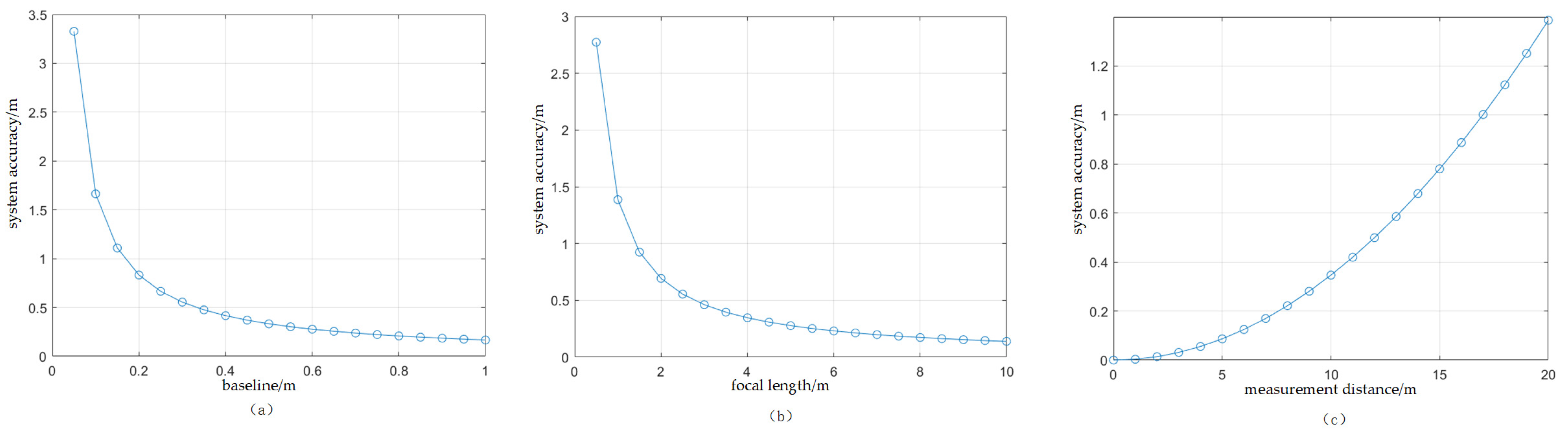
2.2. Measurement Accuracy Analysis of Binocular System
2.3. Parallax Map Acquisition Methods
2.3.1. Calculation of Consideration
2.3.2. Cost Aggregation
2.3.3. Parallax Calculation and Optimization
2.4. Methods for Obtaining Water Level Values
- (1)
- Three randomly selected non-collinear points from the water surface 3D point cloud coordinate dataset are used to determine preliminary planar model , where, , , , are the coefficients of the model;
- (2)
- The distance of every other data point to this plane is calculated according to Equation (13); threshold is set. If , then denotes the interior point and the number of interior points is denoted as ;where is an indicator function that takes the value 1 when condition holds and 0 otherwise and is the total number of data in the dataset, and is the total number of data in dataset ;
- (3)
- According to Equation (14), if the number of interior points of the current model exceeds the previous maximum number of interior points , then the optimal model parameters are updated to ;
- (4)
- The above steps are repeated until a preset number of iterations (1000) is reached, and the model with the highest number of interior points is selected as the final result.
3. Results
3.1. Measuring Range of Binocular System
3.2. Camera Parameter Calibration
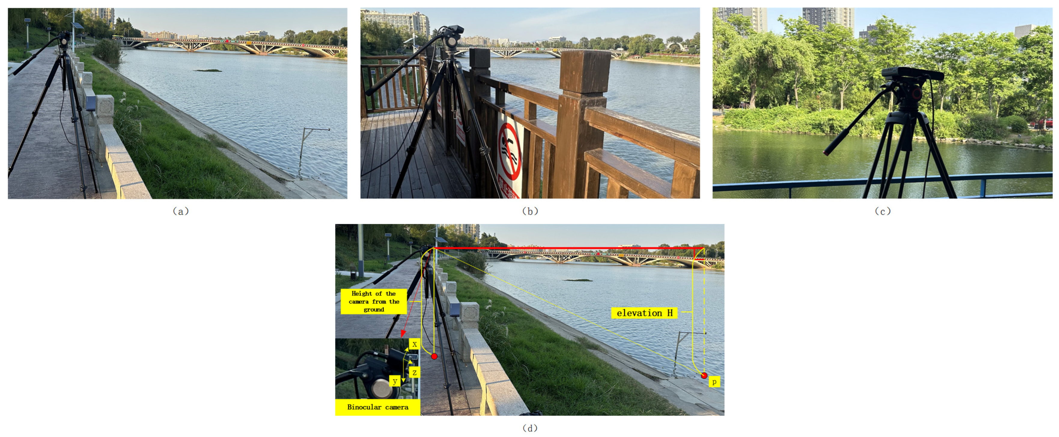
3.3. Experimental Setup
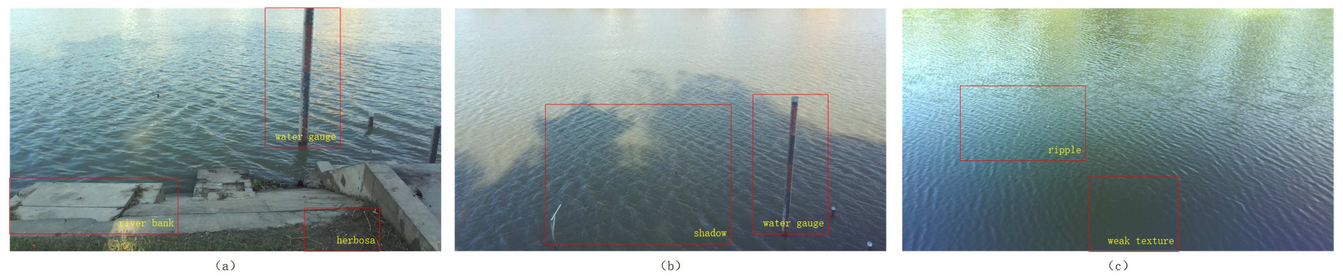
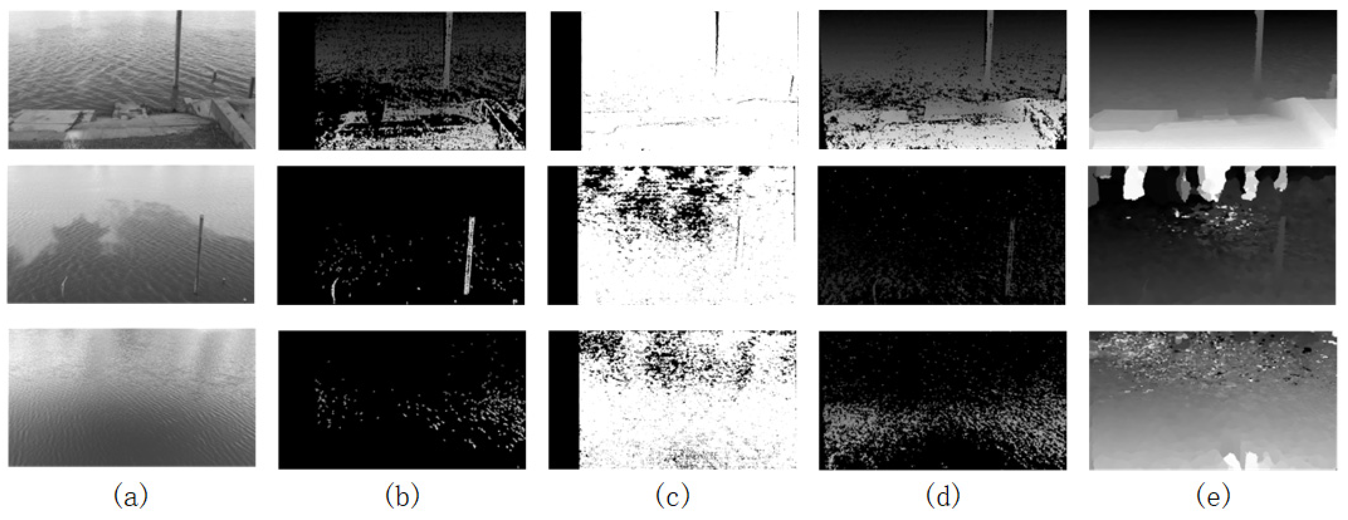
3.4. Water Surface Parallax Map Results
3.5. Elevation Measurement Results
4. Discussion
5. Conclusions
Funding
Institutional Review Board Statement
Informed Consent Statement
Data Availability Statement
Conflicts of Interest
References
- Liu, J.; Bao, Z.; Liu, C.; Wang, G.; Liu, Y.; Wang, J.; Guan, X. Change law and cause analysis of water resources and water consumption in China in past 20 years. Hydro-Sci. Eng. 2019, 41, 31–41. [Google Scholar]
- Huang, J.; Zhang, Y.; Bing, H.; Peng, J.; Dong, F.; Gao, J.; Arhonditsis, G.B. Characterizing the river water quality in China: Recent progress and on-going challenges. Water Res. 2021, 201, 117309. [Google Scholar] [CrossRef] [Scilit]
- Loizou, K.; Koutroulis, E. Water level sensing: State of the art review and performance evaluation of a low-cost measurement system. Measurement 2016, 89, 204–214. [Google Scholar] [CrossRef] [Scilit]
- Djalilov, A.; Sobirov, E.; Nazarov, O.; Urolov, S.; Gayipov, I. Study on automatic water level detection process using ultrasonic sensor. IOP Conf. Ser. Earth Environ. Sci. 2023, 1142, 012020. [Google Scholar] [CrossRef] [Scilit]
- Masoudimoghaddam, M.; Yazdi, J.; Shahsavandi, M. A low-cost ultrasonic sensor for online monitoring of water levels in rivers and channels. Flow Meas. Instrum. 2025, 102, 102777. [Google Scholar] [CrossRef] [Scilit]
- Liao, A.; Liu, J.; Zhang, J.; Jiang, G.; Zheng, J.; Wang, N. Intercomparison of high-accuracy water level gauges in the scale of small experimental catchment. Adv. Water Sci. 2019, 30, 337–347. [Google Scholar]
- Ogasawara, T.; Ashida, K.; Karasawa, K.; Fujita, Y.; Sakai, M. Development and Application Examples of General-Purpose/Small Water Level Gauges. In Proceedings of the 2024 IEEE 13th Global Conference on Consumer Electronics (GCCE), Kitakyushu, Japan, 29 October–1 November 2024; pp. 684–688. [Google Scholar]
- Liu, Y.; Wang, H.; Lei, X. Real-time forecasting of river water level in urban based on radar rainfall: A case study in Fuzhou City. J. Hydrol. 2021, 603, 126820. [Google Scholar] [CrossRef] [Scilit]
- Dhote, P.R.; Agarwal, A.; Singhal, G.; Calmant, S.; Thakur, P.K.; Oubanas, H.; Paris, A.; Singh, R.P. River Water Level and Water Surface Slope Measurement From Spaceborne Radar and LiDAR Altimetry: Evaluation and Implications for Hydrological Studies in the Ganga River. IEEE J. Sel. Top. Appl. Earth Obs. Remote Sens. 2024, 17, 7825–7840. [Google Scholar] [CrossRef] [Scilit]
- Frappart, F.; Blarel, F.; Fayad, I.; Bergé-Nguyen, M.; Crétaux, J.-F.; Shu, S.; Schregenberger, J.; Baghdadi, N. Evaluation of the Performances of Radar and Lidar Altimetry Missions for Water Level Retrievals in Mountainous Environment: The Case of the Swiss Lakes. Remote Sens. 2021, 13, 2196. [Google Scholar] [CrossRef] [Scilit]
- Jan, F.; Min-Allah, N.; Düştegör, D. IoT based smart water quality monitoring: Recent techniques, trends and challenges for domestic applications. Water 2021, 13, 1729. [Google Scholar] [CrossRef] [Scilit]
- Kuo, L.-C.; Tai, C.-C. Robust image-based water-level estimation using single-camera monitoring. IEEE Trans. Instrum. Meas. 2022, 71, 3161691. [Google Scholar] [CrossRef] [Scilit]
- Sun, H.; Wu, G.; Wang, X.; Zhang, T.; Zhang, P.; Chen, W.; Zhu, Q. Research on a Measurement Method for the Ocean Wave Field Based on Stereo Vision. Appl. Sci. 2022, 12, 7447. [Google Scholar] [CrossRef] [Scilit]
- Li, D.; Xiao, L.; Wei, H.; Li, J.; Liu, M. Spatial-temporal measurement of waves in laboratory based on binocular stereo vision and image processing. Coast. Eng. 2022, 177, 104200. [Google Scholar] [CrossRef] [Scilit]
- Liu, C.; Bao, H.; Lan, H.; Yan, C.; Li, C.; Liu, S. Failure evaluation and control factor analysis of slope block instability along traffic corridor in Southeastern Tibet. J. Mt. Sci. 2024, 21, 1830–1848. [Google Scholar] [CrossRef] [Scilit]
- Bao, H.; Rao, Z.; Lan, H.; Yan, C.; Liu, C.; Liu, S. Discrete element modeling method for anisotropic mechanical behavior of biotite quartz schist based on mineral identification technology. Bull. Eng. Geol. Environ. 2025, 84, 28. [Google Scholar] [CrossRef] [Scilit]
- Lu, Y.; Liu, W.; Zhang, Y.; Li, J.; Luo, W.; Zhang, Y.; Xing, H.; Zhang, L. An error analysis and optimization method for combined measurement with binocular vision. Chin. J. Aeronaut. 2021, 34, 282–292. [Google Scholar] [CrossRef] [Scilit]
- Rahim, R.; Ahmar, A.S.; Ardyanti, A.P.; Nofriansyah, D. Visual Approach of Searching Process using Boyer-Moore Algorithm. J. Phys. Conf. Ser. 2017, 930, 012001. [Google Scholar] [CrossRef] [Scilit]
- Hirschmuller, H. Stereo processing by semiglobal matching and mutual information. IEEE Trans. Pattern Anal. Mach. Intell. 2007, 30, 328–341. [Google Scholar] [CrossRef] [Scilit]
- Hou, Y.; Liu, C.; An, B.; Liu, Y. Stereo matching algorithm based on improved Census transform and texture filtering. Optik 2021, 249, 168186. [Google Scholar] [CrossRef] [Scilit]
- Yang, L.; Li, Y.; Li, X.; Meng, Z.; Luo, H. Efficient plane extraction using normal estimation and RANSAC from 3D point cloud. Comput. Stand. Interfaces 2022, 82, 103608. [Google Scholar] [CrossRef] [Scilit]
- Chen, H.; Liang, M.; Liu, W.; Wang, W.; Liu, P.X. An approach to boundary detection for 3D point clouds based on DBSCAN clustering. Pattern Recognit. 2022, 124, 108431. [Google Scholar] [CrossRef] [Scilit]
- Lee, S.; Lim, H.; Myung, H. Patchwork++: Fast and robust ground segmentation solving partial under-segmentation using 3D point cloud. In Proceedings of the 2022 IEEE/RSJ International Conference on Intelligent Robots and Systems (IROS), Kyoto, Japan, 23–27 October 2022; pp. 13276–13283. [Google Scholar]
- Fotsing, C.; Menadjou, N.; Bobda, C. Iterative closest point for accurate plane detection in unorganized point clouds. Autom. Constr. 2021, 125, 103610. [Google Scholar] [CrossRef] [Scilit]
- Mayer, N.; Ilg, E.; Hausser, P.; Fischer, P.; Cremers, D.; Dosovitskiy, A.; Brox, T. A large dataset to train convolutional networks for disparity, optical flow, and scene flow estimation. In Proceedings of the IEEE Conference on Computer Vision and Pattern Recognition, Las Vegas, NV, USA, 27–30 June 2016; pp. 4040–4048. [Google Scholar]
- Geiger, A.; Lenz, P.; Stiller, C.; Urtasun, R. Vision meets robotics: The kitti dataset. Int. J. Robot. Res. 2013, 32, 1231–1237. [Google Scholar] [CrossRef] [Scilit]
- Bao, W.; Wang, W.; Xu, Y.; Guo, Y.; Hong, S.; Zhang, X. InStereo2K: A large real dataset for stereo matching in indoor scenes. Sci. China Inf. Sci. 2020, 63, 212101. [Google Scholar] [CrossRef] [Scilit]
- Scharstein, D.; Hirschmuller, H.; Kiajima, Y.; Krathwohi, G.; Nesic, N.; Wang, X.; Westling, P. High-resolution stereo datasets with subpixel-accurate ground truth. In Proceedings of the Pattern Recognition: 36th German Conference, GCPR 2014, Münster, Germany, 2–5 September 2014; Proceedings 36. pp. 31–42. [Google Scholar] [CrossRef] [Scilit]
- Zheng, J.; Peng, W.; Wang, Y.; Zhai, B. Accelerated RANSAC for accurate image registration in aerial video surveillance. IEEE Access 2021, 9, 36775–36790. [Google Scholar] [CrossRef] [Scilit]
- Xiang, L.; Ding, Y.; Wei, Z.; Zhang, H.; Li, Z. Research on the detection method of tunnel surface flatness based on point cloud data. Symmetry 2021, 13, 2239. [Google Scholar] [CrossRef] [Scilit]
- Shi, P.; Yan, S.; Xiao, Y.; Liu, X.; Zhang, Y.; Li, J. RANSAC back to SOTA: A two-stage consensus filtering for real-time 3D registration. IEEE Robot. Autom. Lett. 2024, 9, 11881–11888. [Google Scholar] [CrossRef] [Scilit]
- Hartley, R.; Zisserman, A. Multiple View Geometry in Computer Vision; Cambridge University Press: Cambridge, UK, 2003. [Google Scholar]
- Abdelsalam, A.; Mansour, M.; Porras, J.; Happonen, A. Depth accuracy analysis of the ZED 2i Stereo Camera in an indoor Environment. Robot. Auton. Syst. 2024, 179, 104753. [Google Scholar] [CrossRef] [Scilit]
- Zhang, Z. A flexible new technique for camera calibration. IEEE Trans. Pattern Anal. Mach. Intell. 2000, 22, 1330–1334. [Google Scholar] [CrossRef] [Scilit]

| Specifications | ZED 2i |
|---|---|
| Resolution | 2208 × 1242, 1920 × 1080, 1280 × 720, 662 × 376 |
| Capture rate | up to100 FPS |
| Focal Length | 4 mm |
| Field of View | 72° |
| Baseline | 120 mm |
| Depth Range | 1.5–35 m |
| Depth Accuracy | <2% up to 10 m, <7% up to 30 m |
| Polarizing Filters | yes |
| internal reference matrix | |
| rotation matrix | |
| translation vector |
| Scenes | A | B | C | D | Measured Elevation Values (m) |
|---|---|---|---|---|---|
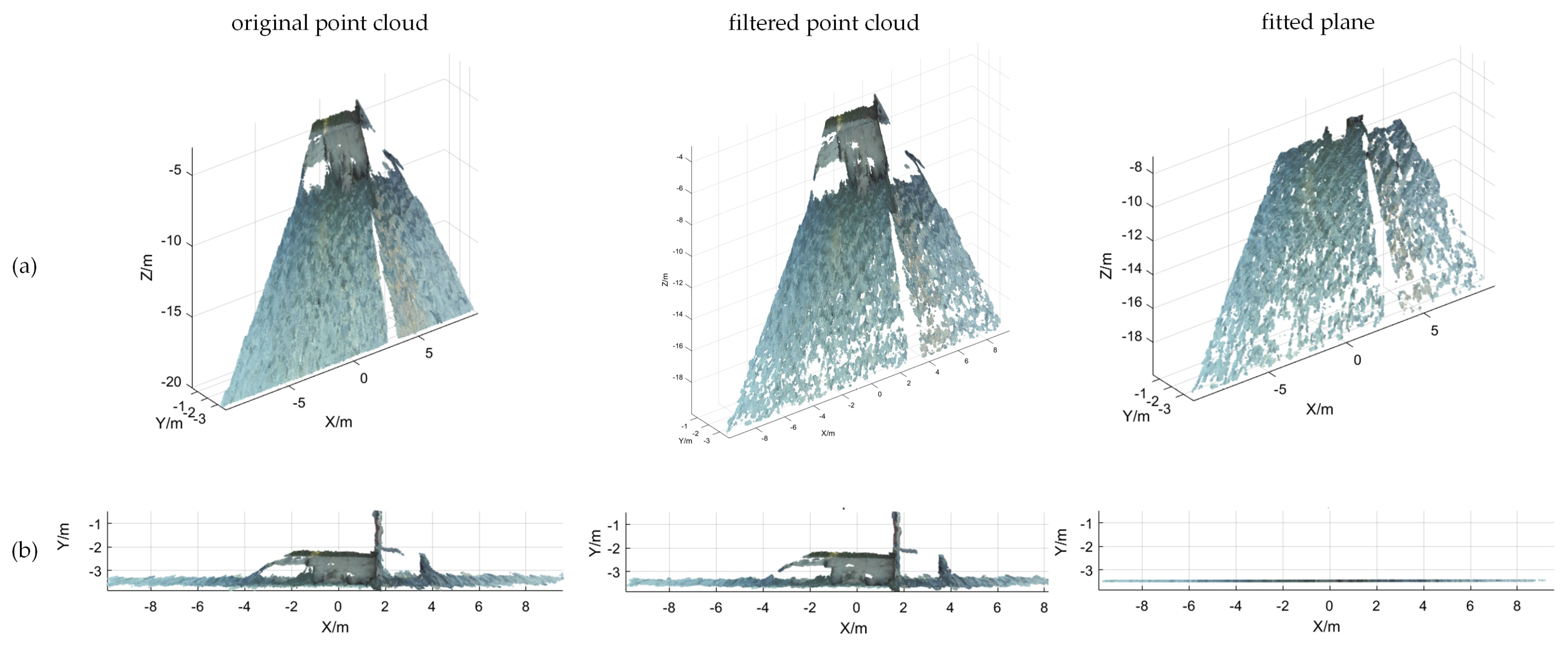
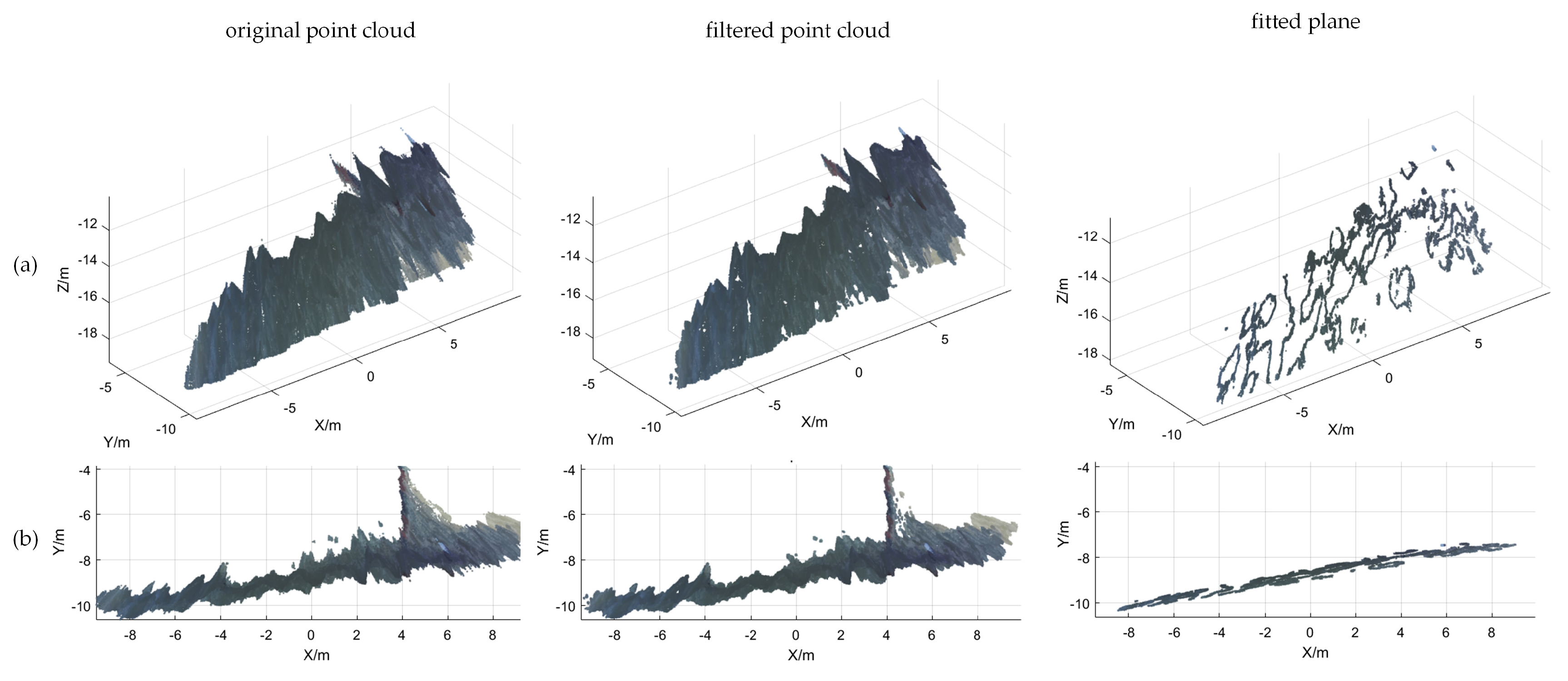
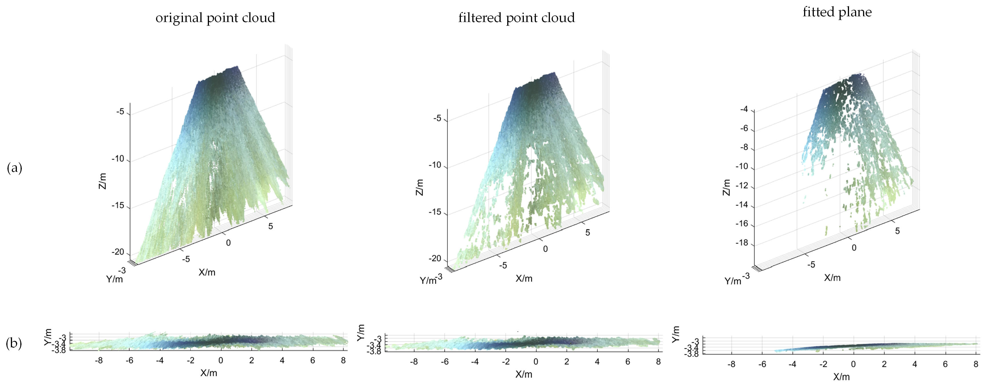
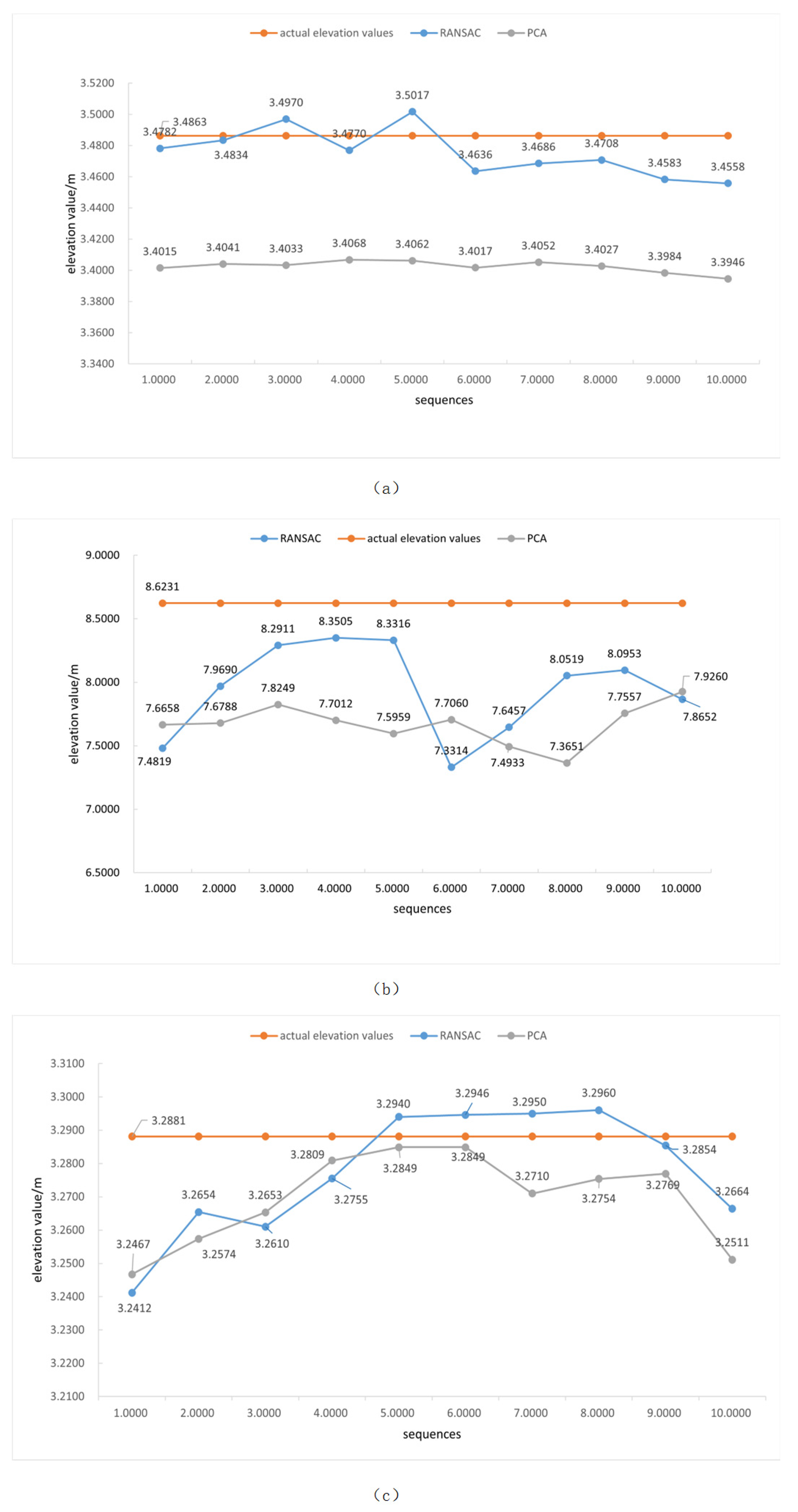
| (a) | −0.001 | 1.001 | −0.014 | 3.479 | 3.4770 |
| (b) | 0.163 | 0.980 | −0.062 | 7.810 | 7.8069 |
| (c) | 0.002 | 1.001 | −0.011 | 3.276 | 3.2755 |
| Sequences | 1 | 2 | 3 | 4 | 5 | 6 | 7 | 8 | 9 | 10 | Average Mean |
|---|---|---|---|---|---|---|---|---|---|---|---|
| scenario (a)/s | |||||||||||
| BM | 4.583 | 4.627 | 4.597 | 4.704 | 4.859 | 4.545 | 4.264 | 4.265 | 4.399 | 4.684 | 4.553 |
| SGM | 38.582 | 41.203 | 38.010 | 40.756 | 37.771 | 56.155 | 40.186 | 39.415 | 36.775 | 38.665 | 40.752 |
| SGBM | 82.279 | 82.338 | 81.857 | 82.422 | 81.148 | 84.002 | 81.323 | 80.090 | 81.394 | 85.244 | 82.210 |
| this paper | 32.218 | 32.345 | 37.678 | 31.987 | 35.432 | 38.123 | 33.789 | 36.543 | 32.001 | 34.872 | 34.499 |
| scenario (b)/s | |||||||||||
| BM | 5.281 | 5.428 | 5.548 | 5.184 | 5.608 | 5.452 | 5.351 | 5.490 | 5.352 | 5.325 | 5.402 |
| SGM | 45.493 | 40.038 | 41.108 | 40.400 | 40.592 | 37.655 | 38.925 | 39.009 | 40.018 | 41.040 | 40.428 |
| SGBM | 85.641 | 84.568 | 84.116 | 83.670 | 84.923 | 108.230 | 83.089 | 83.747 | 83.941 | 83.704 | 86.563 |
| this paper | 35.123 | 34.765 | 37.321 | 38.210 | 35.123 | 39.543 | 40.652 | 39.543 | 32.876 | 40.256 | 37.341 |
| scenario (c)/s | |||||||||||
| BM | 4.545 | 4.327 | 4.499 | 4.596 | 4.778 | 5.655 | 5.568 | 5.331 | 5.691 | 5.342 | 5.033 |
| SGM | 40.389 | 38.805 | 41.099 | 40.525 | 54.763 | 35.984 | 38.762 | 39.505 | 39.650 | 40.216 | 40.970 |
| SGBM | 83.005 | 82.080 | 81.732 | 81.807 | 82.659 | 83.280 | 85.576 | 85.494 | 81.786 | 85.492 | 83.291 |
| this paper | 35.126 | 36.789 | 37.169 | 37.522 | 33.610 | 34.358 | 37.572 | 36.969 | 35.163 | 36.882 | 36.116 |
Disclaimer/Publisher’s Note: The statements, opinions and data contained in all publications are solely those of the individual author(s) and contributor(s) and not of MDPI and/or the editor(s). MDPI and/or the editor(s) disclaim responsibility for any injury to people or property resulting from any ideas, methods, instructions or products referred to in the content. |
© 2025 by the author. Licensee MDPI, Basel, Switzerland. This article is an open access article distributed under the terms and conditions of the Creative Commons Attribution (CC BY) license (https://creativecommons.org/licenses/by/4.0/).
Share and Cite
Jiang, Y. A Rapid Deployment Method for Real-Time Water Surface Elevation Measurement. Sensors 2025, 25, 1850. https://doi.org/10.3390/s25061850
Jiang Y. A Rapid Deployment Method for Real-Time Water Surface Elevation Measurement. Sensors. 2025; 25(6):1850. https://doi.org/10.3390/s25061850
Chicago/Turabian StyleJiang, Yun. 2025. "A Rapid Deployment Method for Real-Time Water Surface Elevation Measurement" Sensors 25, no. 6: 1850. https://doi.org/10.3390/s25061850
APA StyleJiang, Y. (2025). A Rapid Deployment Method for Real-Time Water Surface Elevation Measurement. Sensors, 25(6), 1850. https://doi.org/10.3390/s25061850

