
Precise Positioning in Nitrogen Fertility Sensing in Maize (Zea mays L.)

Abstract
1. Introduction
2. Materials and Methods
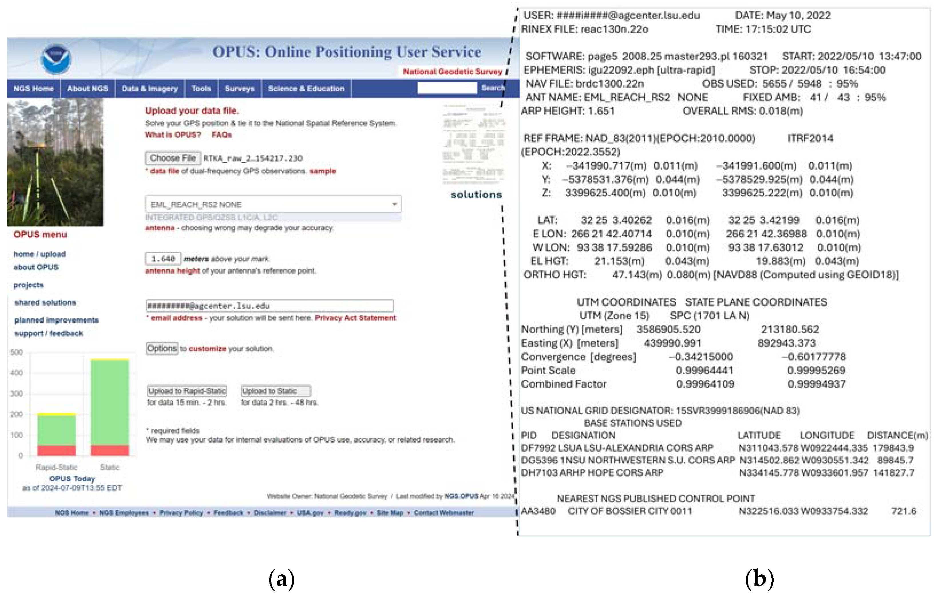
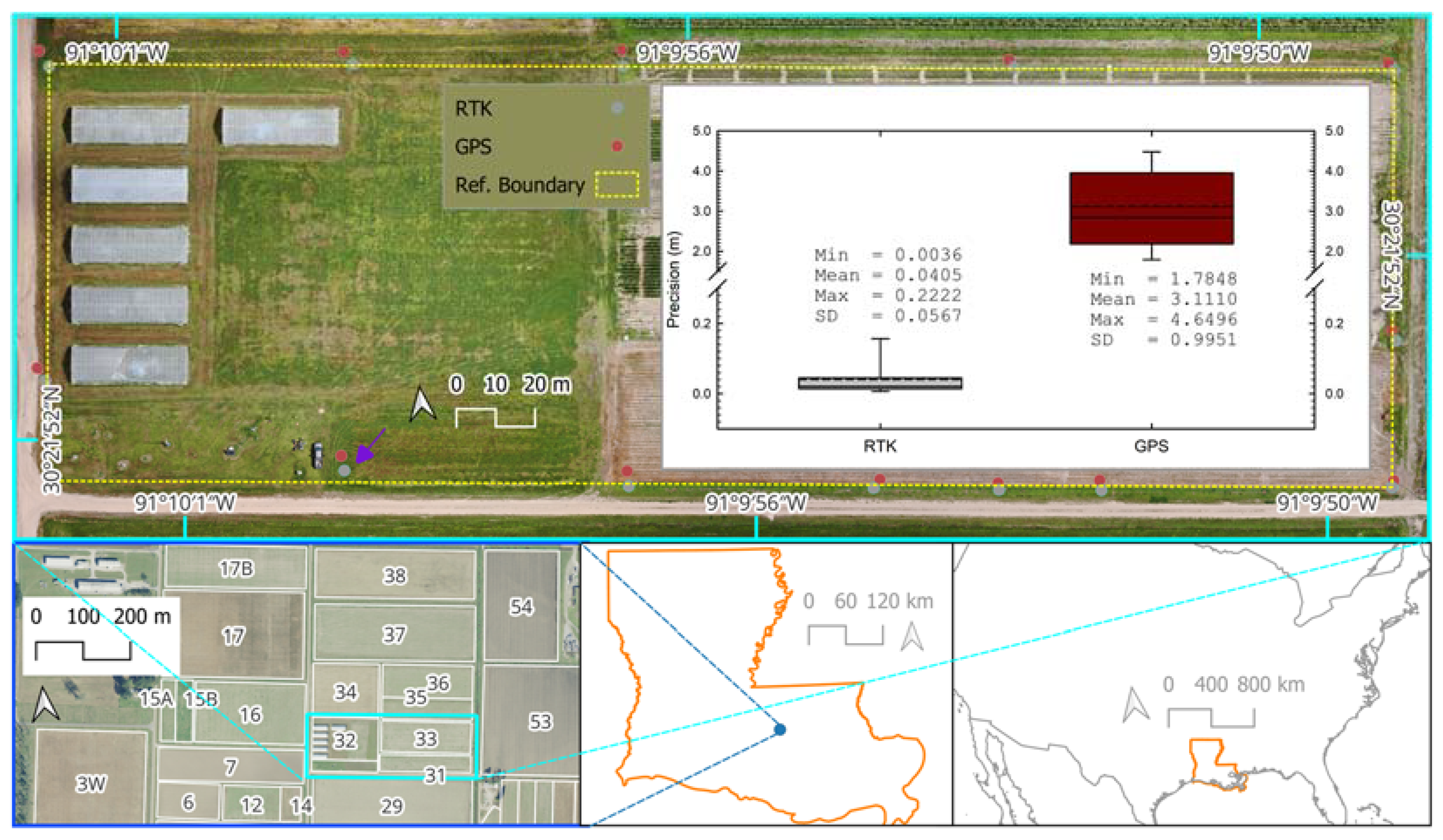
2.1. Comparative Analysis of Position Precision of RTK versus Non-Augmented GPS
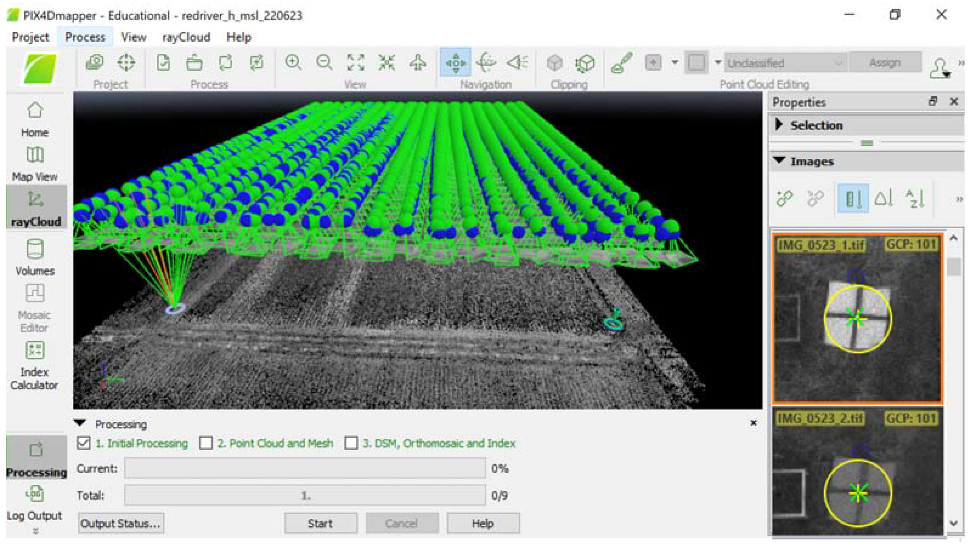
2.2. RTK-GCP Merit Evaluation in UAV Photogrammetry
3. Results
4. Discussion
5. Conclusions
Funding
Institutional Review Board Statement
Informed Consent Statement
Data Availability Statement
Acknowledgments
Conflicts of Interest
References
- Kaplan, E.D.; Hegarthy, C.J. Understanding GPS/GNSS Principles (GNSS Technology and Applications Series), 3rd ed.; Artech House Inc.: Norwood, MA, USA, 2007. [Google Scholar]
- Eissfeller, B.; Ameres, G.; Kropp, V.; Sanroma, D. Performance of GPS, GLONASS, and Galileo. In Photogrammetric Week 2017; Wichmann-Verlag: Heiderberg, Germany, 2017. [Google Scholar]
- Feng, Y.; Wang, J. GPS RTK performance characteristics and analysis. J. Glob. Position. Syst. 2008, 7, 1–8. [Google Scholar] [CrossRef]
- Coyne, P.I.; Casey, S.J.; Milliken, G.A. Comparison of Differentially Corrected GPS Sources for Support of Site-Specific Management in Agriculture; Precision Agriculture Research; Special Publication; Kansas State University Agricultural Experiment Station and Cooperative Extension Service: Manhattan, KS, USA, 2020. [Google Scholar]
- Pini, M.; Marucco, G.; Falco, G.; Nicola, M.; De Wilde, W. Experimental testbed and methodology for the assessment of RTK GNSS receivers used in precision agriculture. IEEE Access 2020, 8, 14690–14703. [Google Scholar] [CrossRef]
- Taylor, R.K.; Kochenower, R.; Arnall, D.B.; Godsey CSolie, J. Driving Accuracy for Strip Tillage in Oklahoma; Paper No. 083546; ASABE: St Joseph, MI, USA, 2008. [Google Scholar]
- Bergtold, J.S.; Raper RL Schwab, E.B. The economic benefit of improving the proximity of tillage and planting operations in cotton production with automatic steering. Appl. Eng. Agric. 2009, 25, 33–143. [Google Scholar] [CrossRef]
- Sun, H.; Slaughter, D.C.; Ruiz, M.P.; Gliever, C.; Upadhyaya, S.K.; Smith, R.F. RTK GPS mapping of transplanted row crops. Comput. Electron. Agric. 2010, 71, 32–37. [Google Scholar] [CrossRef]
- Zhang, K.; Okazawa, H.; Hayashi, K.; Hayashi, T.; Fiwa, L.; Maske, S. Optimization of ground control point distribution for Unmanned Aerial Vehicle photogrammetry for inaccessible fields. Sustainability 2022, 14, 9505. [Google Scholar] [CrossRef]
- Grayson, B.; Penna, N.T.; Mills, J.P.; Grant, D.S. GPS precise point position for UAV photogrammetry. Photogramm. Rec. 2018, 33, 427–447. [Google Scholar] [CrossRef]
- Ackermann, F. Practical experience with GPS supported aerial triangulation. Photogramm. Rec. 1994, 14, 861–874. [Google Scholar] [CrossRef]
- Soler, T.; Wang, G. Interpreting OPUS-static results accurately. J. Surv. Eng. 2016, 142, 05016003. [Google Scholar] [CrossRef]
- GDAL/OGR Contributors. GDAL/OGR Geospatial Data Abstraction Software Library. Open Source Geospatial Foundation. 2023. Available online: https://zenodo.org/records/12545688 (accessed on 29 October 2023).
- QGIS Development Team. QGIS Geographic Information System. Open Source Geospatial Foundation. 2009. Available online: http://qgis.org (accessed on 29 October 2023).
- Barnes, E.M.; Clarke, T.R.; Richards, S.E.; Colaizzi, P.D.; Haberland, J.; Kostrzewski, M.; Waller, P.; Choi, C.; Riley, E.; Thompson, T.; et al. Coincident detection of crop water stress, nitrogen status and canopy density using ground based multispectral data. In Proceedings of the Fifth International Conference on Precision Agriculture, Bloomington, MN, USA, 16–19 July 2000. [Google Scholar]
- Li, W.; Nue, Z.; Chen, H.; Li, D.; Wu, M.; Zhao, W. Remote estimation of canopy height and aboveground biomass of maize using high-resolution stereo images from a low-cost unmanned aerial vehicle system. Ecol. Indic. 2016, 64, 637–648. [Google Scholar] [CrossRef]
- Torino, M.S.; Ortiz, B.V.; Fulton, J.P.; Balkcom, K.S.; Wood, C.W. Evaluation of vegetation indices for early assessment of corn status and yield potential in the Southeastern United States. Agron. J. 2014, 106, 1389–1401. [Google Scholar] [CrossRef]
- Kim, H.; Hyun, C.-U.; Park, H.-D.; Cha, J. Image mapping accuracy evaluation using UAV with standalone, differential (RTK), and PPP GNSS positioning techniques in an abandoned mine site. Sensors 2023, 23, 5858. [Google Scholar] [CrossRef] [PubMed]
- Keshavarzi, H.; Lee, C.; Johnson, M.; Abbott, D.; Ni, W.; Campbell, M. Validation of Real-Time Kinematic (RTK) devices on sheep to detect grazing movement leaders and social networks in Merino Ewes. Sensors 2021, 21, 924. [Google Scholar] [CrossRef] [PubMed]
- Janos, D.; Kuras, P.; Ortyl, L. Evaluation of low-cost RTK GNSS receiver in motion under demanding conditions. Measurement 2022, 201, 111647. [Google Scholar] [CrossRef]
- Osco, L.P.; Mercato Junior, J.; Ramos, A.P.M.; Furuya, D.E.G.; Santana, D.C.; Teodoro, L.P.R.; Gonçalves, W.N.; Baio, F.H.R.; Pistori, H.; da Silva Junior, C.A.; et al. Leaf nitrogen concentration and plant height prediction for maize using UAV-based multispectral imagery and machine learning techniques. Remote Sens. 2020, 12, 3237. [Google Scholar] [CrossRef]
- Burns, B.W.; Green, V.S.; Hashem, A.A.; Massey, J.H.; Shew, A.M.; Adviento-Borbe, M.A.A.; Milad, M. Determining nitrogen deficiencies for maize using various remote sensing indices. Precis. Agric. 2022, 23, 791–811. [Google Scholar] [CrossRef]
- Heineman, P.; Schmidhalter, U. Spectral assessments of N-related maize traits: Evaluating and defining agronomic relevant detection limits. Field Crops Res. 2022, 289, 108710. [Google Scholar] [CrossRef]
- Pipatsitee, P.; Tisarum, R.; Taota, K.; Samphumphuang, T.; Eiumnoh, A.; Singh, H.P.; Cha-um, S. Effectiveness of vegetation indices and UAV-multispectral imageries in assessing the response of hybrid maize (Zea mays L.) to water deficit stress under field environment. Environ. Monit. Assess. 2023, 195, 128. [Google Scholar] [CrossRef] [PubMed]
- Feizolahpour, F.; Besharat, S.; Feizizadeh BBakhtiar Feizizadeh Rezaverdinejad, V.; Hessari, B. An integrative data-driven approach for monitoring corn biomass under irrigation water and nitrogen levels based on UAV-based imagery. Environ. Monit. Assess. 2023, 195, 1081. [Google Scholar] [CrossRef] [PubMed]


| Case | RTK | GPS | Geographic Location | ||||
|---|---|---|---|---|---|---|---|
| x (cm) | y (cm) | xy (cm) | x (cm) | y (cm) | xy (cm) | ||
| This study | 5.92 | 3.32 | 4.05 | 115.74 | 304.19 | 311.11 | Bossier parish, LA, USA |
| Reference study 1 [18] | 6.03 | 5.17 | 8.70 | 146.17 | 54.10 | 164.10 | Gyeongsangnam-do, Republic of Korea |
| Reference study 2 [19] | * | * | 10.00 | * | * | * | Marsfield, New South Wales, Australia |
| Reference study 3 [20] | 1.94 | 2.40 | * | * | * | * | Henryk Jordan Park, Krakow, Poland |
Disclaimer/Publisher’s Note: The statements, opinions and data contained in all publications are solely those of the individual author(s) and contributor(s) and not of MDPI and/or the editor(s). MDPI and/or the editor(s) disclaim responsibility for any injury to people or property resulting from any ideas, methods, instructions or products referred to in the content. |
© 2024 by the author. Licensee MDPI, Basel, Switzerland. This article is an open access article distributed under the terms and conditions of the Creative Commons Attribution (CC BY) license (https://creativecommons.org/licenses/by/4.0/).
Share and Cite
Setiyono, T. Precise Positioning in Nitrogen Fertility Sensing in Maize (Zea mays L.). Sensors 2024, 24, 5322. https://doi.org/10.3390/s24165322
Setiyono T. Precise Positioning in Nitrogen Fertility Sensing in Maize (Zea mays L.). Sensors. 2024; 24(16):5322. https://doi.org/10.3390/s24165322
Chicago/Turabian StyleSetiyono, Tri. 2024. "Precise Positioning in Nitrogen Fertility Sensing in Maize (Zea mays L.)" Sensors 24, no. 16: 5322. https://doi.org/10.3390/s24165322
APA StyleSetiyono, T. (2024). Precise Positioning in Nitrogen Fertility Sensing in Maize (Zea mays L.). Sensors, 24(16), 5322. https://doi.org/10.3390/s24165322