
Present-Day Crustal Velocity Field in Ecuador from cGPS Position Time Series


Abstract
1. Introduction
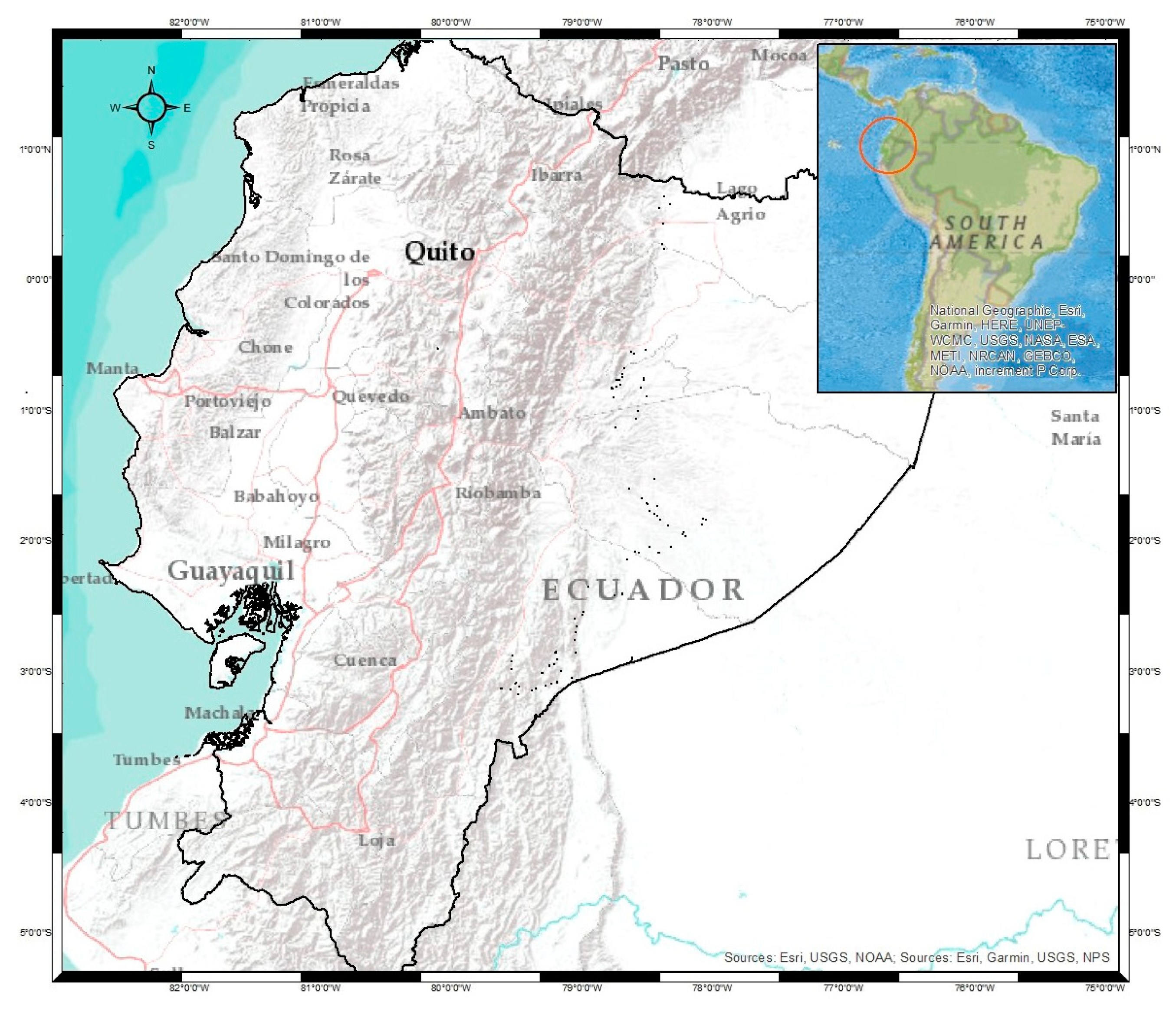
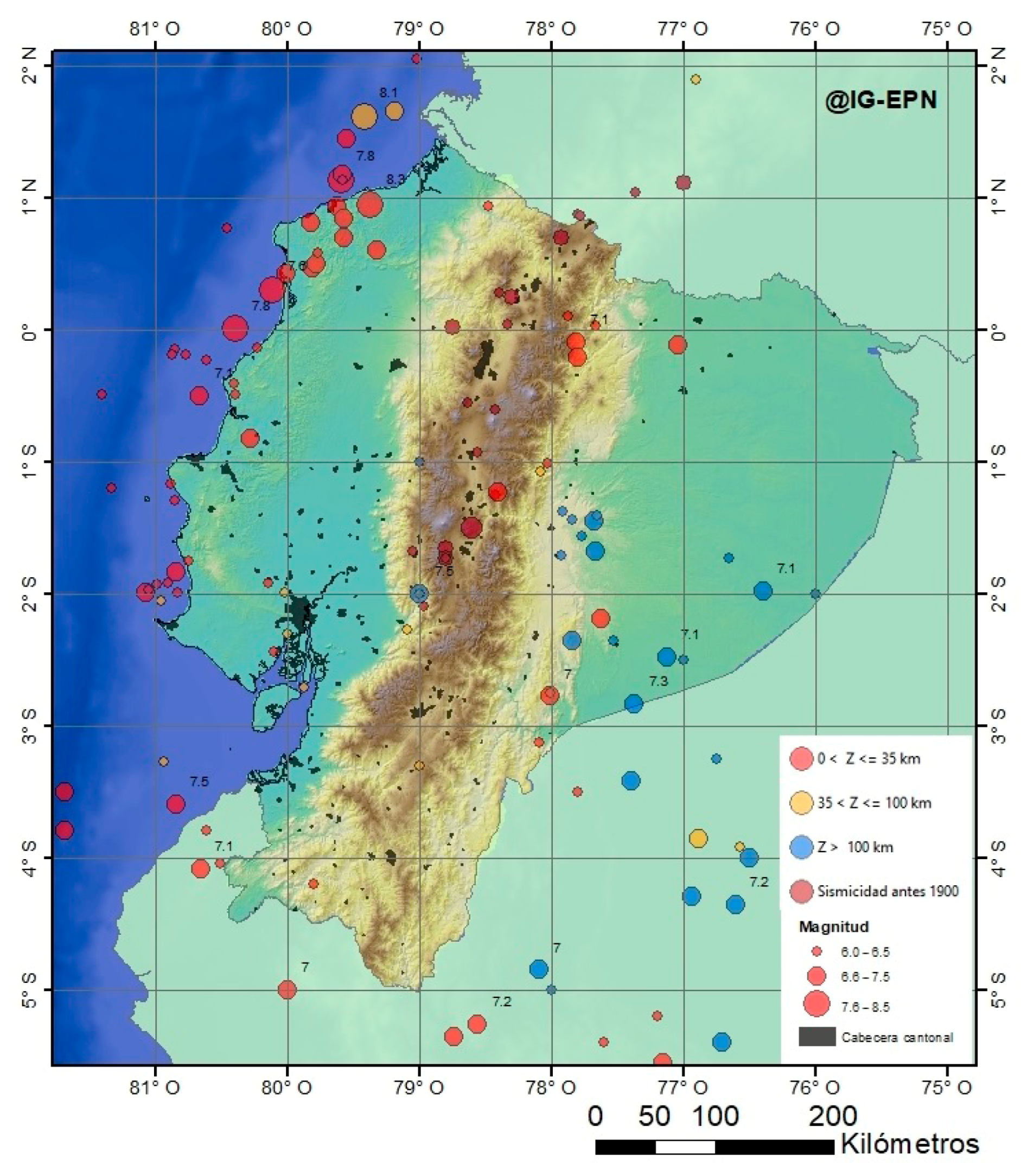
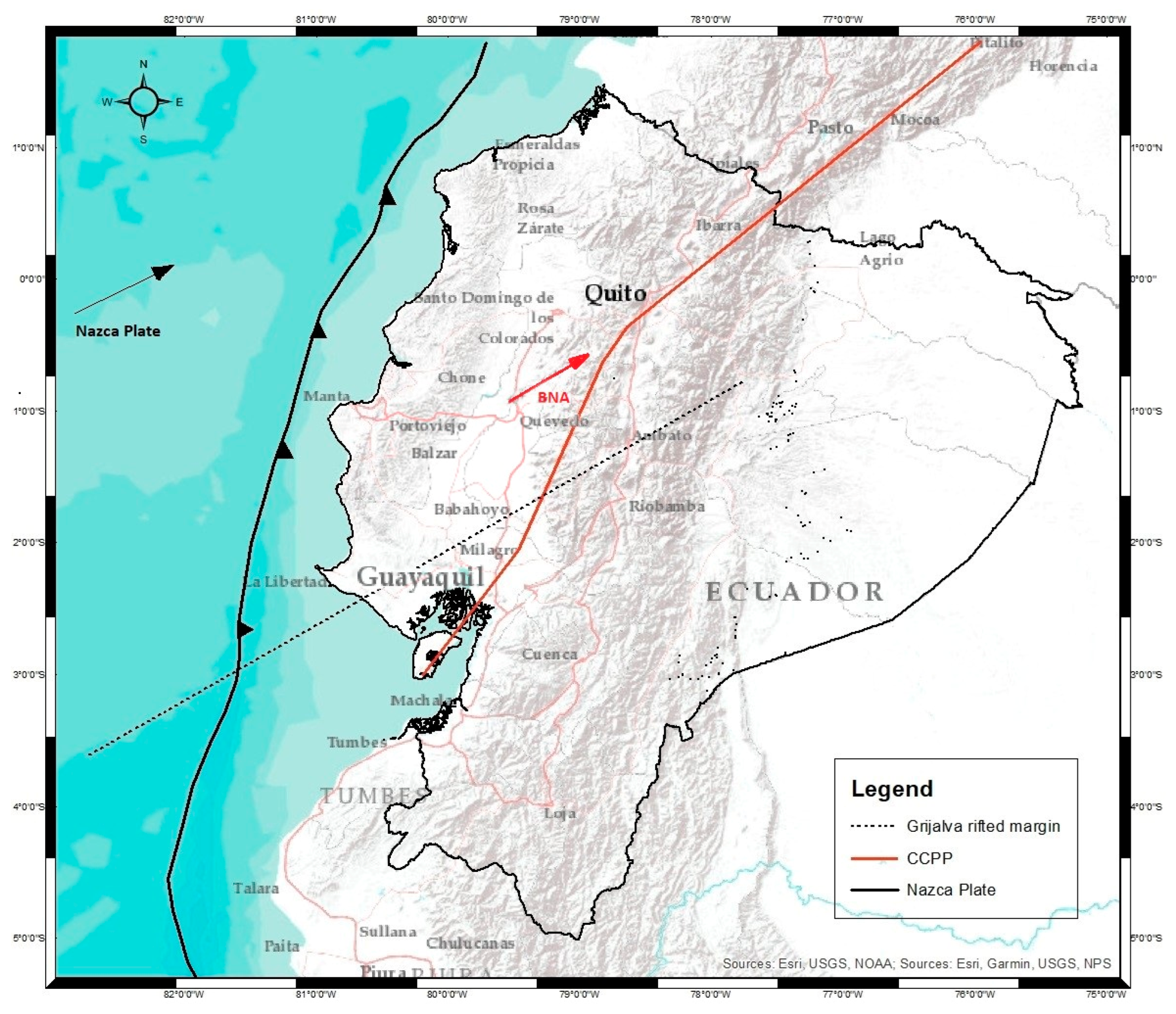
2. Tectonic Setting
3. Methodology
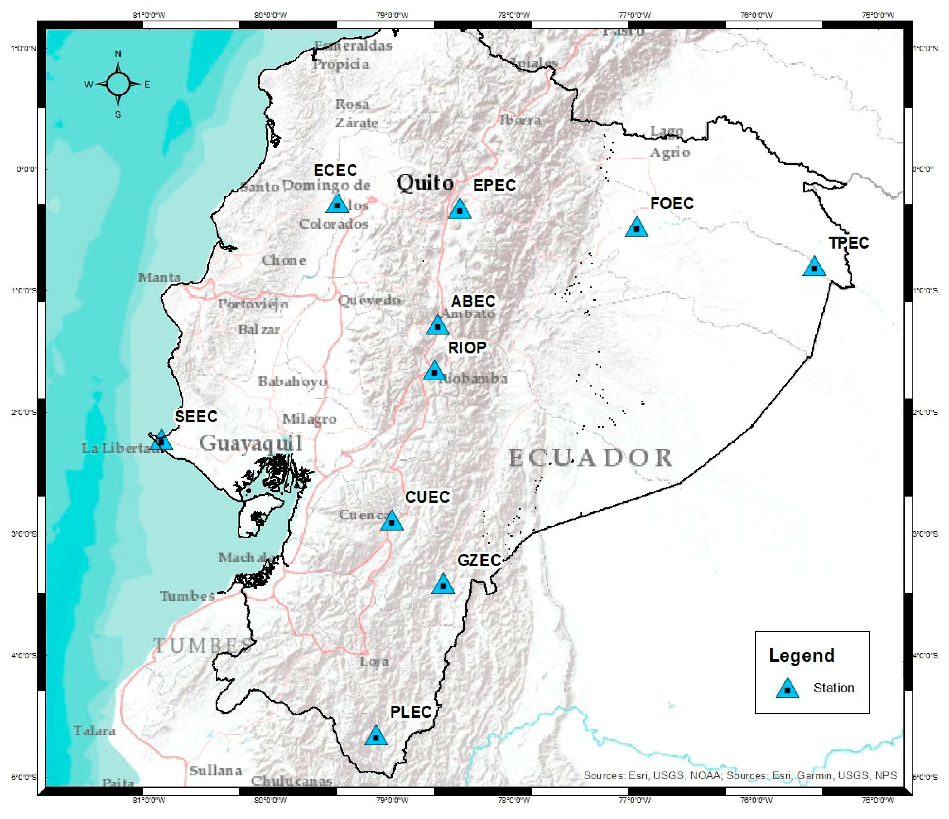
3.1. GNSS Data Processing
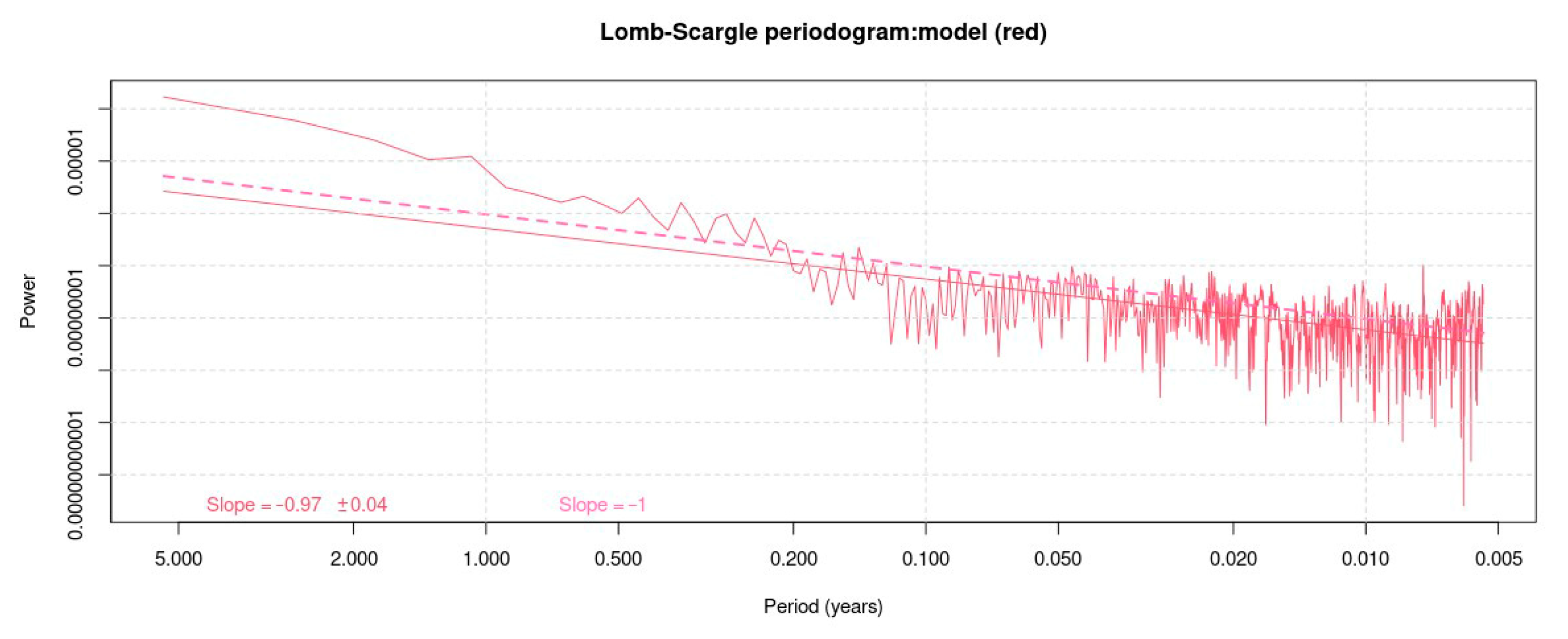
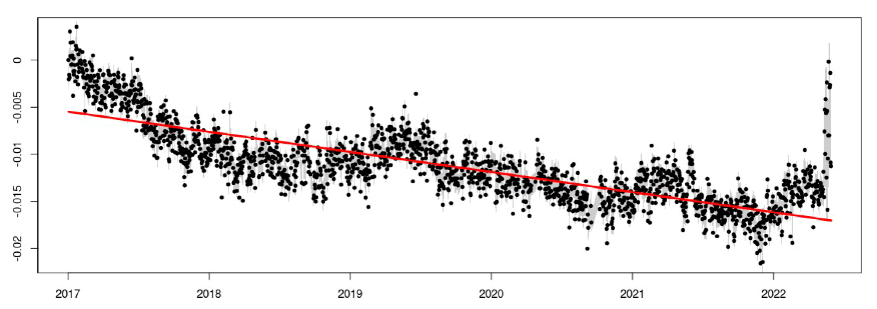
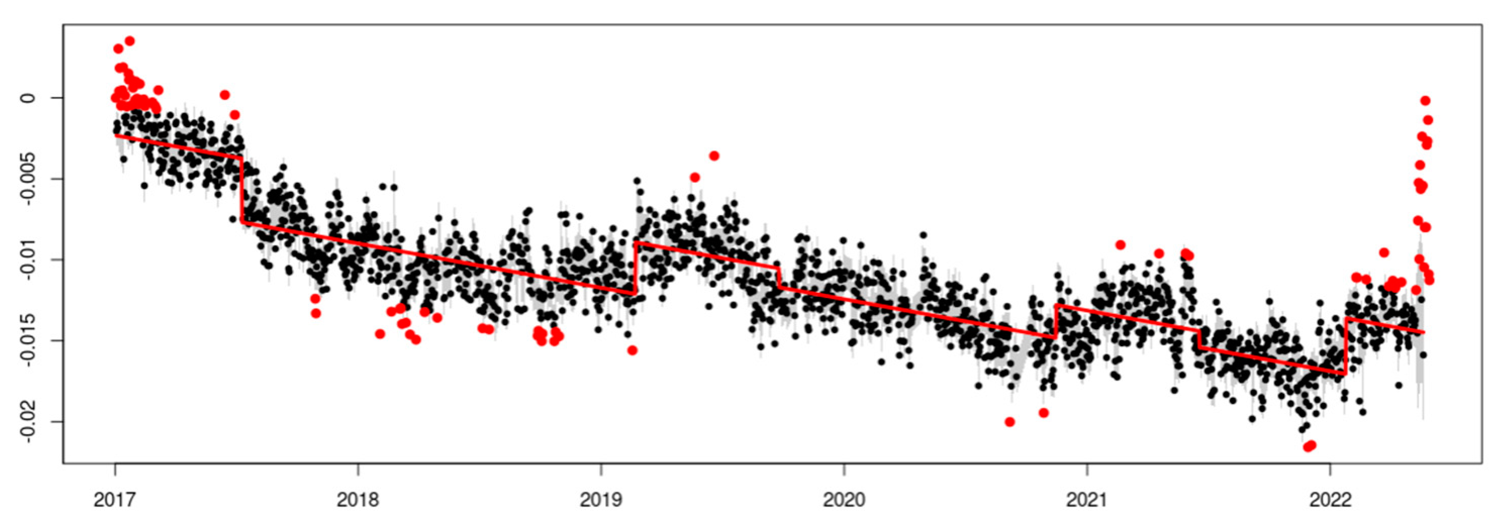
3.2. GPS Position Time Series
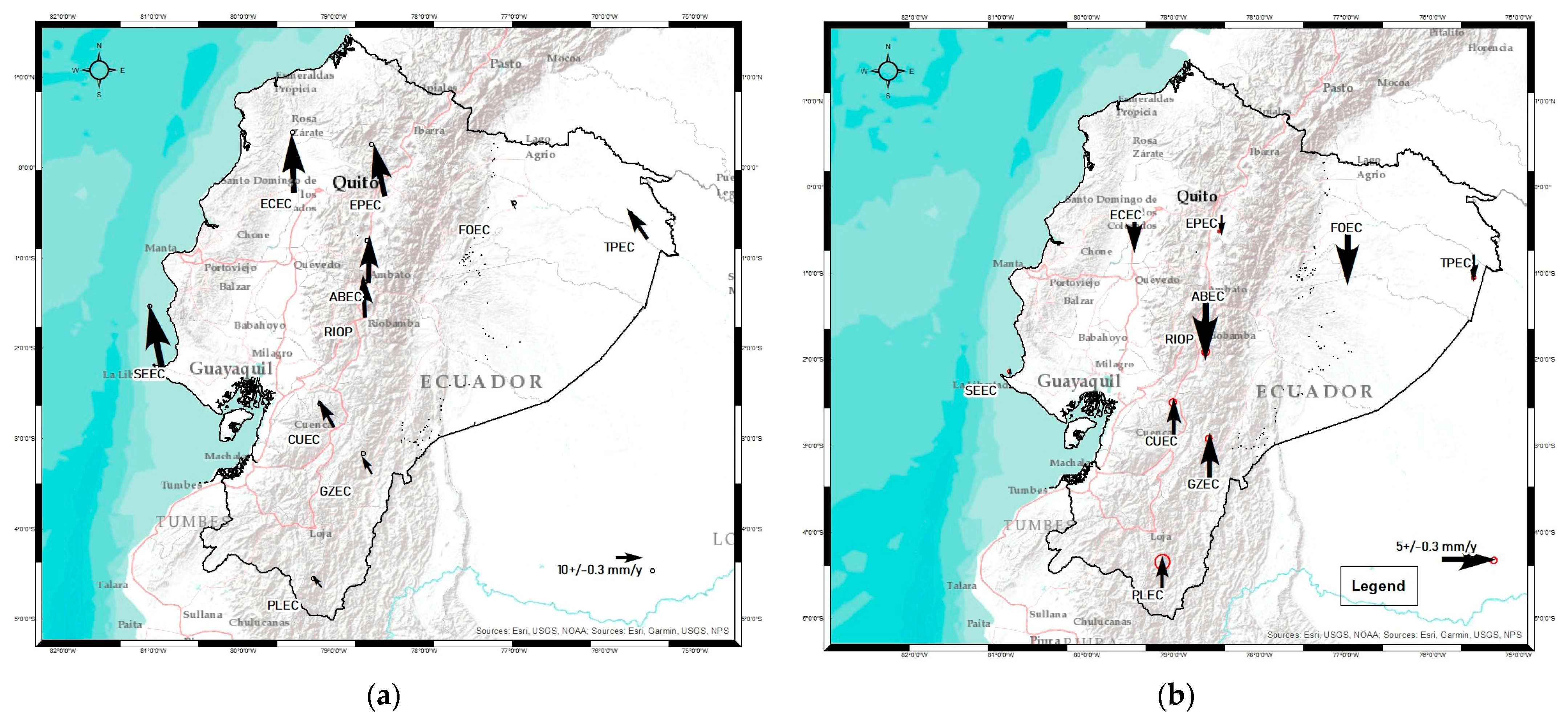
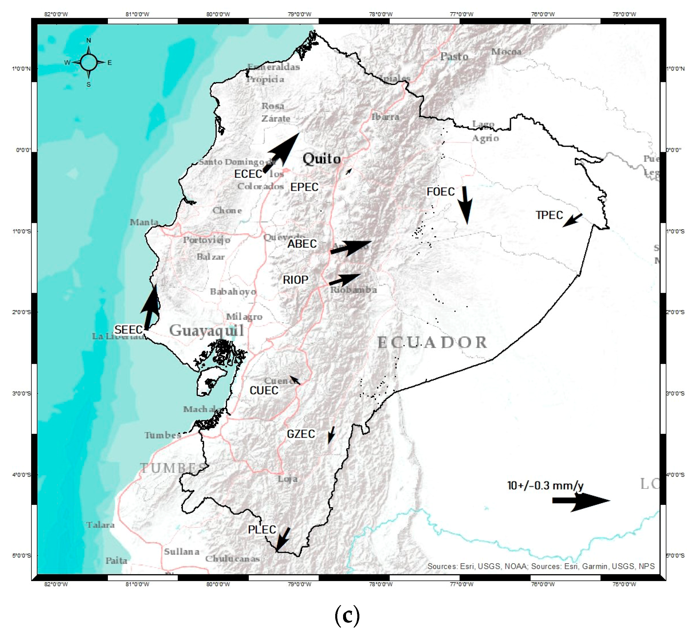
4. Results and Discussion
5. Conclusions
Author Contributions
Funding
Institutional Review Board Statement
Informed Consent Statement
Data Availability Statement
Conflicts of Interest
References
- McClusky, S.; Balassanian, S.; Barka, A.; Demir, C.; Ergintav, S.; Georgiev, I.; Gurkan, O.; Hamburger, M.; Hurst, K.; Kahle, H.; et al. Global Positioning System constraints on plate kinematics and dynamics in the eastern Mediterranean and Caucasus. J. Geophys. Res. Solid Earth 2000, 105, 5695–5719. [Google Scholar] [CrossRef]
- Müller, M.; Geiger, A.; Kahle, H.-G.; Veis, G.; Billiris, H.; Paradissis, D.; Felekis, S. Velocity and deformation fields in the North Aegean domain, Greece, and implications for fault kinematics, derived from GPS data 1993–2009. Tectonophysics 2013, 598, 34–49. [Google Scholar] [CrossRef]
- Luna, M. Contribución a la Definición de un Modelo de Velocidades de la Corteza Terrestre Para Ecuador a Partir de Datos GNSS; Universidad Politécnica de Madrid: Madrid, Spain, 2017. [Google Scholar]
- Quishpe, R.; Tabera, H.; Bernal, I. Geometria de la Placa de Nazca en el Borde Occidental de Sudamerica a Partir de las Tendencias Medias de Sismicidad; Boletin de la Sociedad Geologica dl Perú: Lima, Peru, 2003; pp. 93–110. [Google Scholar]
- Drewes, H. Differential Coordinate Changes (Velocities) vs. Coordinate Differences (Epoch Coordinates) for Realising the Time Dependency of the ITRF. 2017. Available online: https://www.sirgas.org/fileadmin/docs/Boletines/2017_Drewes_Differential_coordinate_changes_vs_coordinate_differences_for_ITRF_IAG_Kobe.pdf (accessed on 2 September 2022).
- Gil, A.J.; Galindo-Zaldívar, J.; de Galdeano, C.S.; Borque, M.J.; Sánchez-Alzola, A.; Martinez-Martos, M.; Alfaro, P. The Padul normal fault activity constrained by GPS data: Brittle extension orthogonal to folding in the central Betic Cordillera. Tectonophysics 2017, 713, 64–71. [Google Scholar] [CrossRef]
- Sánchez-Alzola, A.; Martí, J.; García-Yeguas, A.; Gil, A.J. Subsidence and current strain patterns on Tenerife Island (Canary Archipelago, Spain) derived from continuous GNSS time series (2008–2015). J. Volcanol. Geotherm. Res. 2016, 327, 240–248. [Google Scholar] [CrossRef]
- Sboras, S.; Lazos, I.; Mouzakiotis, E.; Karastathis, V.; Pavlides, S.; Chatzipetros, A. Fault modeling, seismic sequence evolution and stress transfer scenarios for the 20 July 2017 (M W 6.6) Kos–Gökova Gulf earthquake, SE Aegean. Acta Geophys. 2020, 68, 1245–1261. [Google Scholar] [CrossRef]
- Gutscher, M.A.; Spakman, W.; Bijwaard, H.; Engdahl, E.R. Geodynamics of flat subduction: Seismicity and tomographic constraints from the Andean margin. Tectonics 2000, 19, 814–833. [Google Scholar] [CrossRef]
- Chunga, K.; Pazmiño, N.; Martillo, C.; Quiñonez, M.; Huaman, F. Estimación de máximos niveles de sismicidad para el Litoral Ecuatoriano a través de la integración de datos geológicos y sismo-tectónicos. Rev. Científica Y Tecnológica UPSE 2013, 1, 1–13. [Google Scholar] [CrossRef]
- Tamay, J.; Galindo-Zaldivar, J.; Soto, J.; Gil, A.J. Gnss constraints to active tectonic deformations of the south american continental margin in Ecuador. Sensors 2021, 21, 4003. [Google Scholar] [CrossRef]
- Bethoux, N.; Segovia, M.; Alvarez, V.; Collot, J.-Y.; Charvis, P.; Gailler, A.; Monfret, T. Seismological study of the central Ecuadorian margin: Evidence of upper plate deformation. J. S. Am. Earth Sci. 2011, 31, 139–152. [Google Scholar] [CrossRef]
- Martillo, C.; Pazmiño, A.; Chunga, K.; Resl, R. Descripción morfológica de la plataforma continental del Ecuador y análisis comparativo con la plataforma jurídica mediante la aplicación de sistemas de información geográfica. Acta Ocean. 2021, 16, 109–118. [Google Scholar] [CrossRef]
- Instituto Geofísico del Ecuador-Escuela Politécnica Nacional, Catalogos Sísmicos. Available online: https://www.igepn.edu.ec/catalogos-sismicos (accessed on 2 September 2022).
- Yepes, H.; Audin, L.; Alvarado, A.; Beauval, C.; Aguilar, J.; Font, Y.; Cotton, F. A new view for the geodynamics of Ecuador: Implication in seismogenic source definition and seismic hazard assessment. Tectonics 2016, 35, 1249–1279. [Google Scholar] [CrossRef]
- Łyszkowicz, A.; Pelc-Mieczkowska, R.; Bernatowicz, A.; Savchuk, S. First Results of Time Series Analysis of the Permanent GNSS Observations at Polish EPN Stations Using GipsyX Software. Artif. Satell. 2021, 56, 101–118. [Google Scholar] [CrossRef]
- Oficina de Informacion Diplomatica del Ecuador, República del Ecuador Ficha País. 2021. Available online: https://www.exteriores.gob.es/Documents/FichasPais/ECUADOR_FICHAPAIS.pdf (accessed on 2 September 2022).
- Savchuk, S.; Khoptar, A. Analysis of the Tropospheric Delay Estimates in Software Package—Gipsyx Based on Multi-Gnss Observations. 2018. Available online: http://zgt.com.ua/wp-content/uploads/2019/04/13.pdf (accessed on 2 September 2022).
- Luna, M.P.; Staller, A.; Toulkeridis, T.; Parra, H. Methodological approach for the estimation of a new velocity model for continental Ecuador. Open Geosci. 2017, 9, 719–734. [Google Scholar] [CrossRef]
- IGS. IGS Site Guidelines. Organization. 2015, pp. 1–9. Available online: https://igs.org/news/rt-guidelines-now-available/s (accessed on 2 September 2022).
- Bertiger, W.; Bar-Sever, Y.; Dorsey, A.; Haines, B.; Harvey, N.; Hemberger, D.; Heflin, M.; Lu, W.; Miller, M.; Moore, A.W.; et al. GipsyX/RTGx, a new tool set for space geodetic operations and research. Adv. Sp. Res. 2020, 66, 469–489. [Google Scholar] [CrossRef]
- Borque, M.J.; Sánchez-Alzola, A.; Martin-Rojas, I.; Alfaro, P.; Molina, S.; Rosa-Cintas, S.; Rodríguez-Caderot, G.; Lacy, C.; García-Armenteros, J.A.; Avilés, M.; et al. How Much Nubia-Eurasia Convergence Is Accommodated by the NE End of the Eastern Betic Shear Zone (SE Spain)? Constraints From GPS Velocities. Tectonics 2019, 38, 1824–1839. [Google Scholar] [CrossRef]
- Petit, G.; Luzum, B. IERS Conventions (2010). J. Geod. 2010, 77, 585–678. [Google Scholar] [CrossRef]
- Drewe, H.; Sanchez, L. Curso de Sistemas de Referencia. 2011. Available online: https://d1wqtxts1xzle7.cloudfront.net/34116028/Curso_Sistemas_Refrencia_Drewes_Sanchez_Santiago_Chile_sep_2011_1-with-cover-page-v2.pdf?Expires=1656755538&Signature=b-DpdxCeKMe~nW7emKwOiew9ue5w56MVUc~wNBHeMKQVQiVtz7sb9n4qvRkP1E8IZAzFGUWUmnBf-7Ye91DEBc3y8o (accessed on 2 September 2022).
- Amiri-Simkooei, A.R.; Tiberius, C.C.J.M.; Teunissen, P.J.G. Assessment of noise in GPS coordinate time series: Methodology and results. J. Geophys. Res. Solid Earth 2007, 112, 1–19. [Google Scholar] [CrossRef]
- Lahtinen, S.; Jivall, L.; Häkli, P.; Kall, T.; Kollo, K.; Kosenko, K.; Galinauskas, K.; Prizginiene, D.; Tangen, O.; Weber, M.; et al. Densification of the ITRF2014 position and velocity solution in the Nordic and Baltic countries. GPS Solut. 2019, 23, 95. [Google Scholar] [CrossRef]
- Wdowinski, S.; Zhang, J.; Fang, P. Southern California Permanent GPS Geodetic Array: Spatial filtering of daily positions for estimating coseismic and postseismic displacements induced by the 1992 Landers earthquake. J. Geophys. Res. 1997, 102, 57–70. [Google Scholar] [CrossRef]
- Prochniewicz, D.; Kudrys, J.; Maciuk, K. Noises in Double-Differenced GNSS Observations. Energies 2022, 15, 1668. [Google Scholar] [CrossRef]
- Santamaría-Gómez, A. SARI: Interactive GNSS position time series analysis software. GPS Solut. 2019, 23, 52. [Google Scholar] [CrossRef]
- Hackl, M.; Malservisi, R.; Hugentobler, U.; Wonnacott, R. Estimation of velocity uncertainties from GPS time series: Examples from the analysis of the South African TrigNet network. J. Geophys. Res. Solid Earth 2011, 116, 1–12. [Google Scholar] [CrossRef]
- Agnew, D.C. The time-domain behavior of power-law noises. Geophys. Res. Lett. 1992, 19, 333–336. [Google Scholar] [CrossRef]
- Kaczmarek, A.; Kontny, B. Identification of the noise model in the time series of GNSS stations coordinates using wavelet analysis. Remote Sens. 2018, 10, 1611. [Google Scholar] [CrossRef]
- Altamimi, Z.; Métivier, L.; Rebischung, P.; Rouby, H.; Collilieux, X. ITRF2014 plate motion model. Geophys. J. Int. 2017, 209, 1906–1912. [Google Scholar] [CrossRef]
- Cisneros, D.; Nocquet, J.-M. Actualización Preliminar del Sistema Nacional de Referencia Espacial-SIRGAS-Ecuador, Posterior al Terremoto de Pedernales 7.8 Mw, 16 de abril de 2016. Rev. Geofis. 2017, 67, 41–79. Available online: https://www.revistasipgh.org/index.php/regeofi/article/view/161 (accessed on 2 September 2022).
- Sánchez, L.; Drewes, H. Crustal deformation and surface kinematics after the 2010 earthquakes in Latin America. J. Geodyn. 2016, 102, 1–23. [Google Scholar] [CrossRef]


| Stations Analyzed | |||||
|---|---|---|---|---|---|
| Station | Years | Years Range | Antenna/Receptor | ||
| Receiver Changes | Antenna Changes | Start Date | |||
| ABEC | 6 | 2017–2022 | 2 | 1 | January 2017 |
| CUEC | 6 | 2017–2022 | 0 | 0 | January 2017 |
| ECEC | 6 | 2017–2022 | 0 | 0 | January 2017 |
| EPEC | 6 | 2017–2022 | 0 | 0 | January 2017 |
| FOEC | 6 | 2017–2022 | 2 | 2 | January 2017 |
| PLEC | 6 | 2017–2022 | 1 | 1 | October 2017 |
| RIOP | 6 | 2017–2022 | 0 | 0 | January 2017 |
| SEEC | 6 | 2017–2022 | 0 | 0 | January 2017 |
| STEC | 4 | 2019–2022 | 0 | 0 | April 2019 |
| TPEC | 5 | 2018–2022 | 0 | 0 | January 2018 |
| Geodetic Coordinates (deg.) | Velocity (mm/year) | Uncertainty (mm/year) | Residual Velocity (mm/year) | |||||||
|---|---|---|---|---|---|---|---|---|---|---|
| Station | Lat. (N) | Long. (E) | ve | vn | vup | σe | σn | σup | ve | vn |
| ABEC | −1.268 | −78.627 | 0.23 | 11.19 | −5.58 | 0.06 | 0.10 | 0.32 | 4.36 | 1.21 |
| CUEC | −2.883 | −79.003 | −5.12 | 8.87 | 2.51 | 0.18 | 0.03 | 0.14 | −1.50 | 1.27 |
| ECEC | −0.272 | −79.452 | −0.66 | 13.68 | −4.29 | 0.11 | 0.09 | 0.07 | 3.49 | 3.86 |
| EPEC | −0.315 | −78.446 | −2.37 | 11.24 | −0.83 | 0.13 | 0.06 | 0.12 | 1.18 | 1.27 |
| FOEC | −0.463 | −76.990 | −3.43 | 6.33 | −5.60 | 0.08 | 0.21 | 0.22 | 0.36 | −4.03 |
| GZEC | −3.401 | −78.581 | −4.30 | 7.57 | 4.71 | 0.17 | 0.11 | 0.20 | −0.74 | −2.42 |
| PLEC | −4.651 | −79.132 | −5.31 | 6.34 | 1.87 | 0.23 | 0.08 | 0.38 | −1.63 | −3.01 |
| RIOP | −1.651 | −78.651 | −0.57 | 11.05 | 0.51 | 0.05 | 0.09 | 0.35 | 3.40 | 1.11 |
| SEEC | −2.220 | −80.904 | −2.95 | 14.49 | 0.35 | 0.13 | 0.12 | 0.32 | 1.04 | 4.90 |
| TPEC | −0.790 | −75.527 | −6.01 | 8.93 | −1.03 | 0.12 | 0.21 | 0.53 | −2.13 | −1.46 |
| Last Study (mm/year) | This Study (mm/year) | Difference (mm/year) | |||||||||
|---|---|---|---|---|---|---|---|---|---|---|---|
| ve | vn | vup | Time | ve | vn | vup | Time | e | n | up | |
| CUEC | −0.26 | 7.96 | 1.6 | 2008–2014 | −5.12 | 8.87 | 2.51 | 2017–2022 | 4.86 | −0.91 | −0.91 |
| ECEC | 12.32 | 14.5 | −8.95 | 2012–2014 | −0.66 | 13.68 | −4.29 | 2017–2022 | 12.98 | 0.82 | −4.66 |
| EPEC | 5.01 | 8.31 | −3.16 | 2013–2014 | −2.37 | 11.24 | −0.83 | 2017–2022 | 7.38 | −2.93 | −2.33 |
| GZEC | −0.24 | 6.33 | 1.59 | 2012–2014 | −4.30 | 7.57 | 4.71 | 2017–2022 | 4.06 | −1.24 | −3.12 |
| RIOP | 1.63 | 6.92 | 0.69 | 2008–2014 | −0.57 | 11.05 | 0.51 | 2017–2022 | 2.20 | −4.13 | 0.18 |
| SEEC | 9.85 | 13.14 | −1.18 | 2012–2014 | −2.95 | 14.49 | 0.35 | 2017–2022 | 12.80 | −1.35 | −1.53 |
Disclaimer/Publisher’s Note: The statements, opinions and data contained in all publications are solely those of the individual author(s) and contributor(s) and not of MDPI and/or the editor(s). MDPI and/or the editor(s) disclaim responsibility for any injury to people or property resulting from any ideas, methods, instructions or products referred to in the content. |
© 2023 by the authors. Licensee MDPI, Basel, Switzerland. This article is an open access article distributed under the terms and conditions of the Creative Commons Attribution (CC BY) license (https://creativecommons.org/licenses/by/4.0/).
Share and Cite
Arias-Gallegos, A.; Borque-Arancón, M.J.; Gil-Cruz, A.J. Present-Day Crustal Velocity Field in Ecuador from cGPS Position Time Series. Sensors 2023, 23, 3301. https://doi.org/10.3390/s23063301
Arias-Gallegos A, Borque-Arancón MJ, Gil-Cruz AJ. Present-Day Crustal Velocity Field in Ecuador from cGPS Position Time Series. Sensors. 2023; 23(6):3301. https://doi.org/10.3390/s23063301
Chicago/Turabian StyleArias-Gallegos, Alejandro, Mᵃ Jesús Borque-Arancón, and Antonio J. Gil-Cruz. 2023. "Present-Day Crustal Velocity Field in Ecuador from cGPS Position Time Series" Sensors 23, no. 6: 3301. https://doi.org/10.3390/s23063301
APA StyleArias-Gallegos, A., Borque-Arancón, M. J., & Gil-Cruz, A. J. (2023). Present-Day Crustal Velocity Field in Ecuador from cGPS Position Time Series. Sensors, 23(6), 3301. https://doi.org/10.3390/s23063301