Monitoring Land Degradation Dynamics to Support Landscape Restoration Actions in Remote Areas of the Mediterranean Basin (Murcia Region, Spain)
Abstract
:1. Introduction
2. Stepping into a New Decade of Monitoring Ecosystem Restoration Camps
2.1. A New Envisioning for the Indicator 16—Above Ground Carbon Capture
2.2. Google Earth Engine Applied to Land Monitoring Framework
3. Materials and Methods
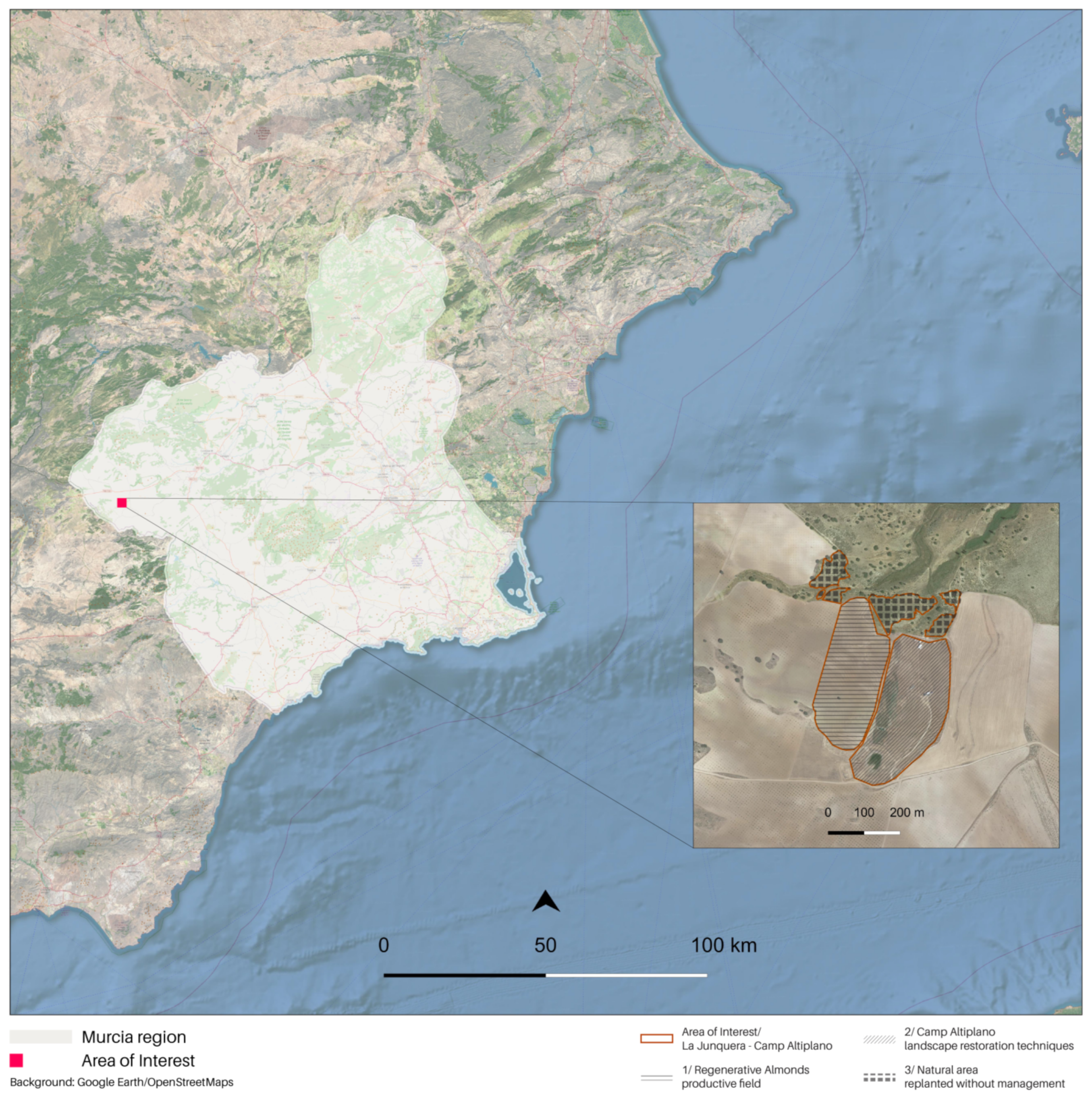
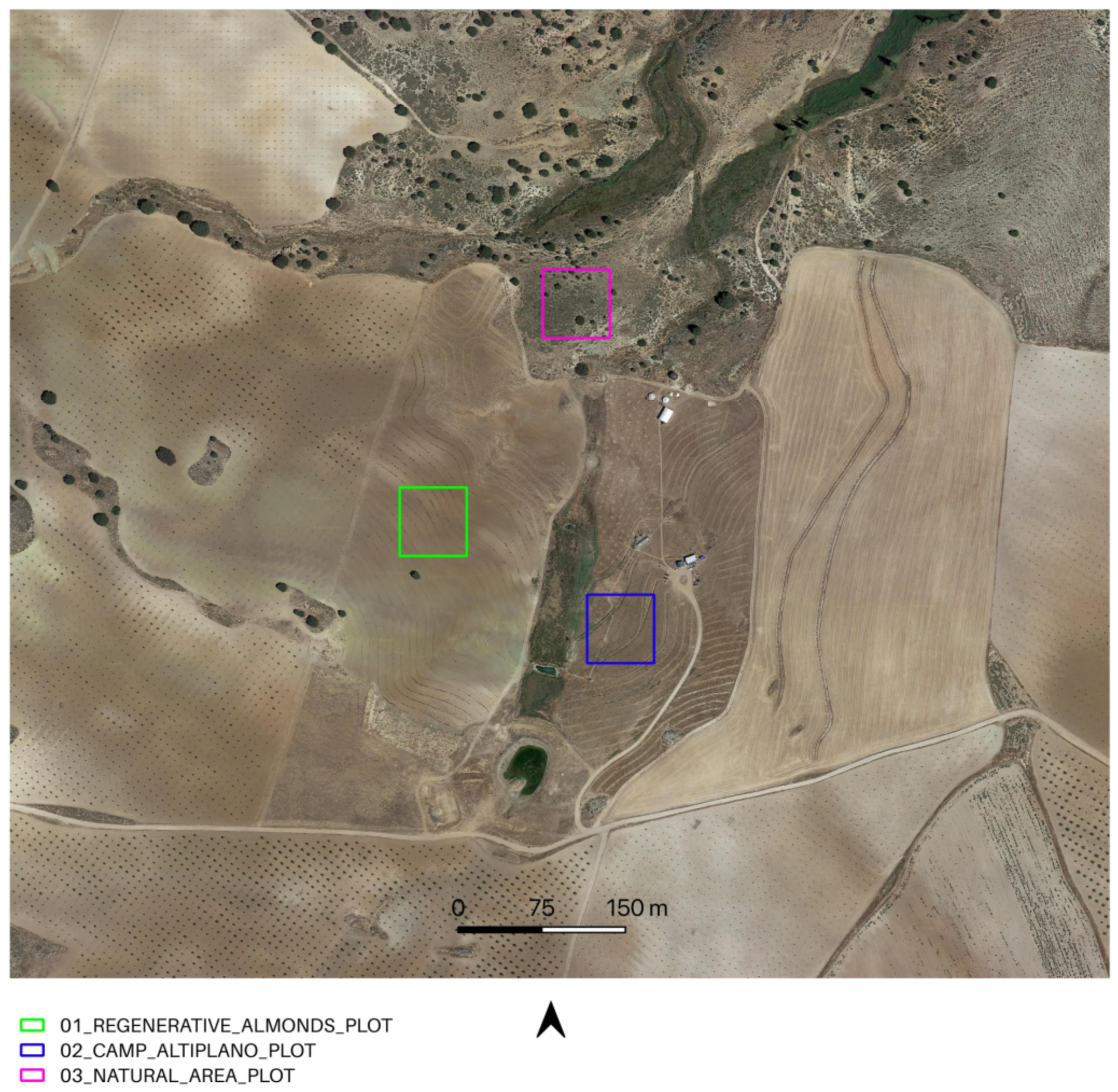
3.1. Land Restoration Actions Monitoring—The Area of Interest
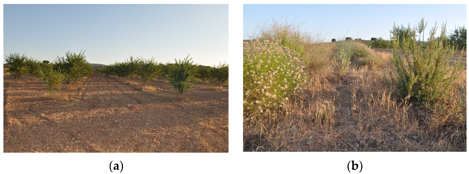
3.1.1. La Junquera—Regenerative Almonds, Productive Field
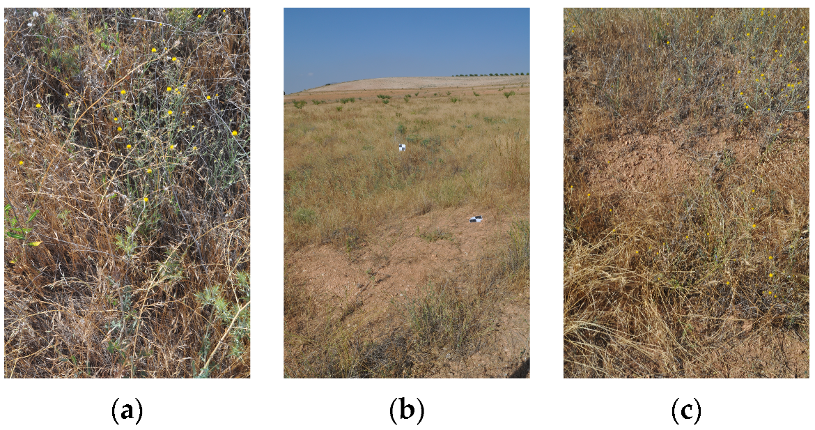
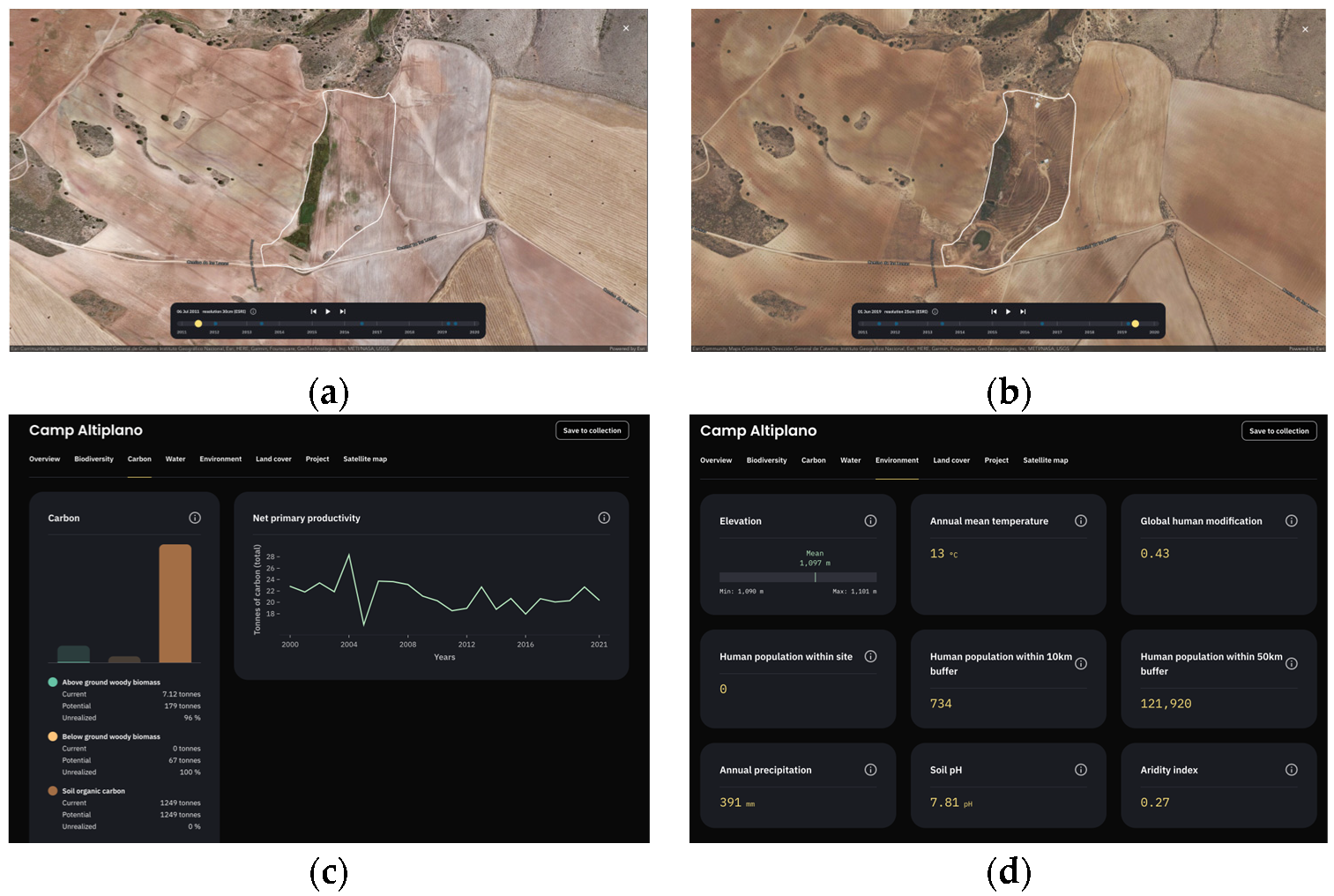
3.1.2. Camp Altiplano—Landscape Restoration Technique, Riparian Zone and Forest Garden
3.1.3. Camp Altiplano—Landscape Restoration Technique, Swales, and Natural Corridors
3.2. Data Collection and Methodology
3.2.1. First Part of the rGEE Code—MODIS/Terra-MOD13Q1 NDVI
3.2.2. Second Part of the rGEE Code—COPERNICUS/S2_S
3.2.3. Third Part of the rGEE Code—Sample COPERNICUS/S2_SR SOS-EOS and WS NDVI
4. Results
4.1. Analysis of the NDVI Phenological Profiles of the AOI—MODIS/006/MOD13Q1 NDVI (First Part of the rGEE Code)
4.2. Analysis of the NDVI SOS-EOS and WS Time Intervals—COPERNICUS/S2_SR (Second part of the rGEE Code)
- Inizio modulo
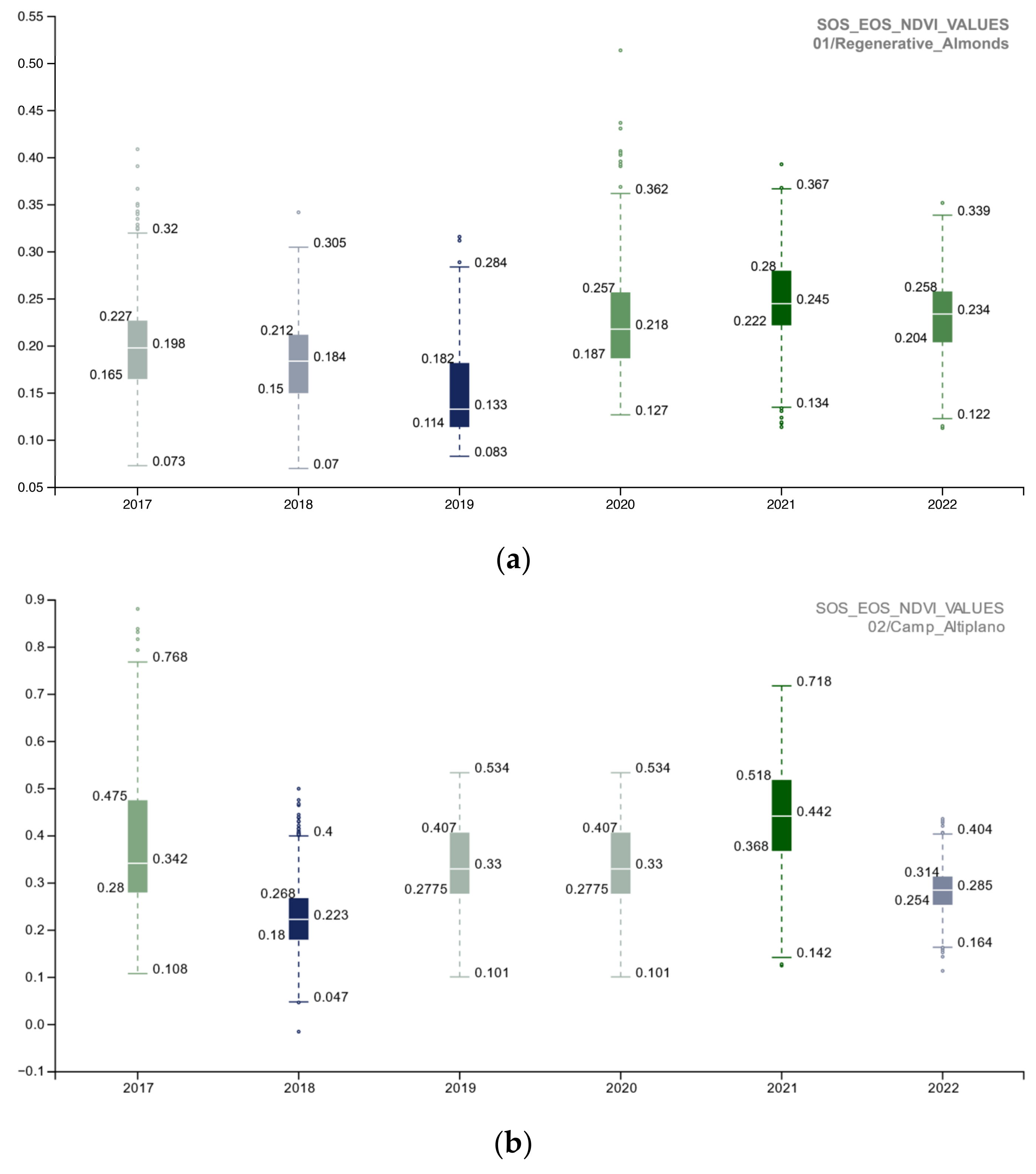
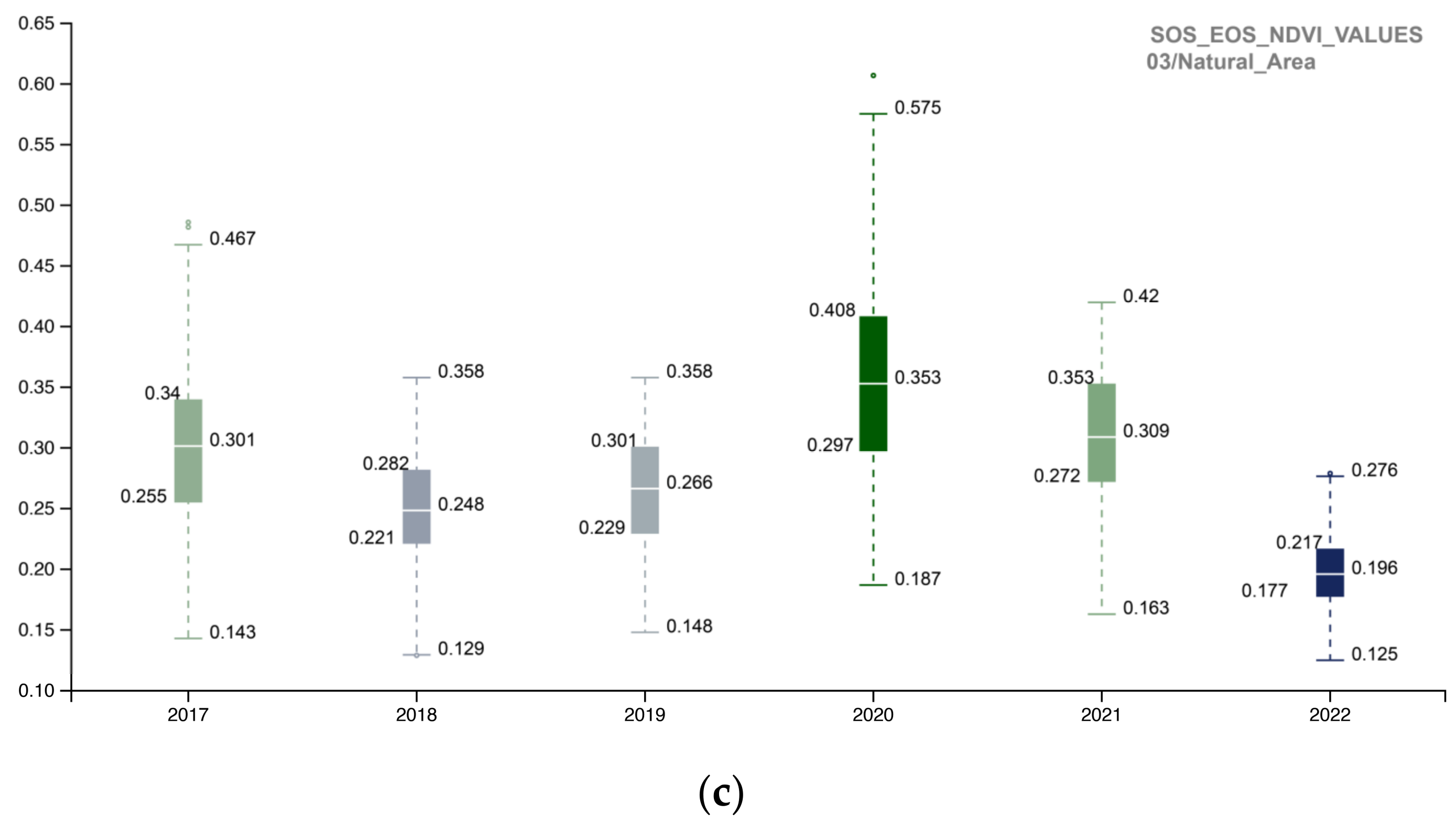
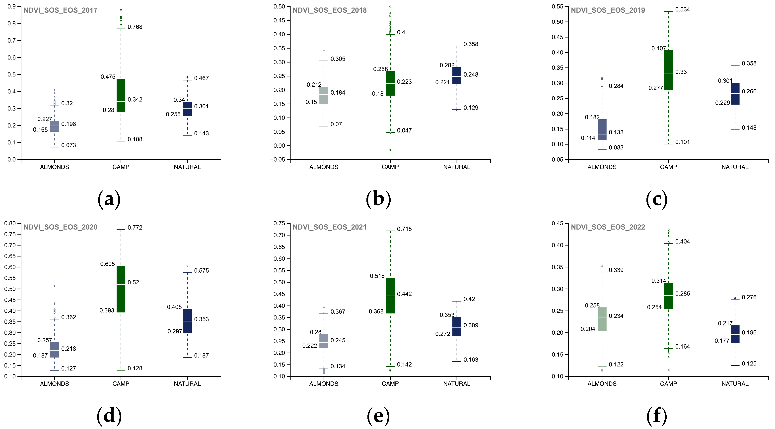
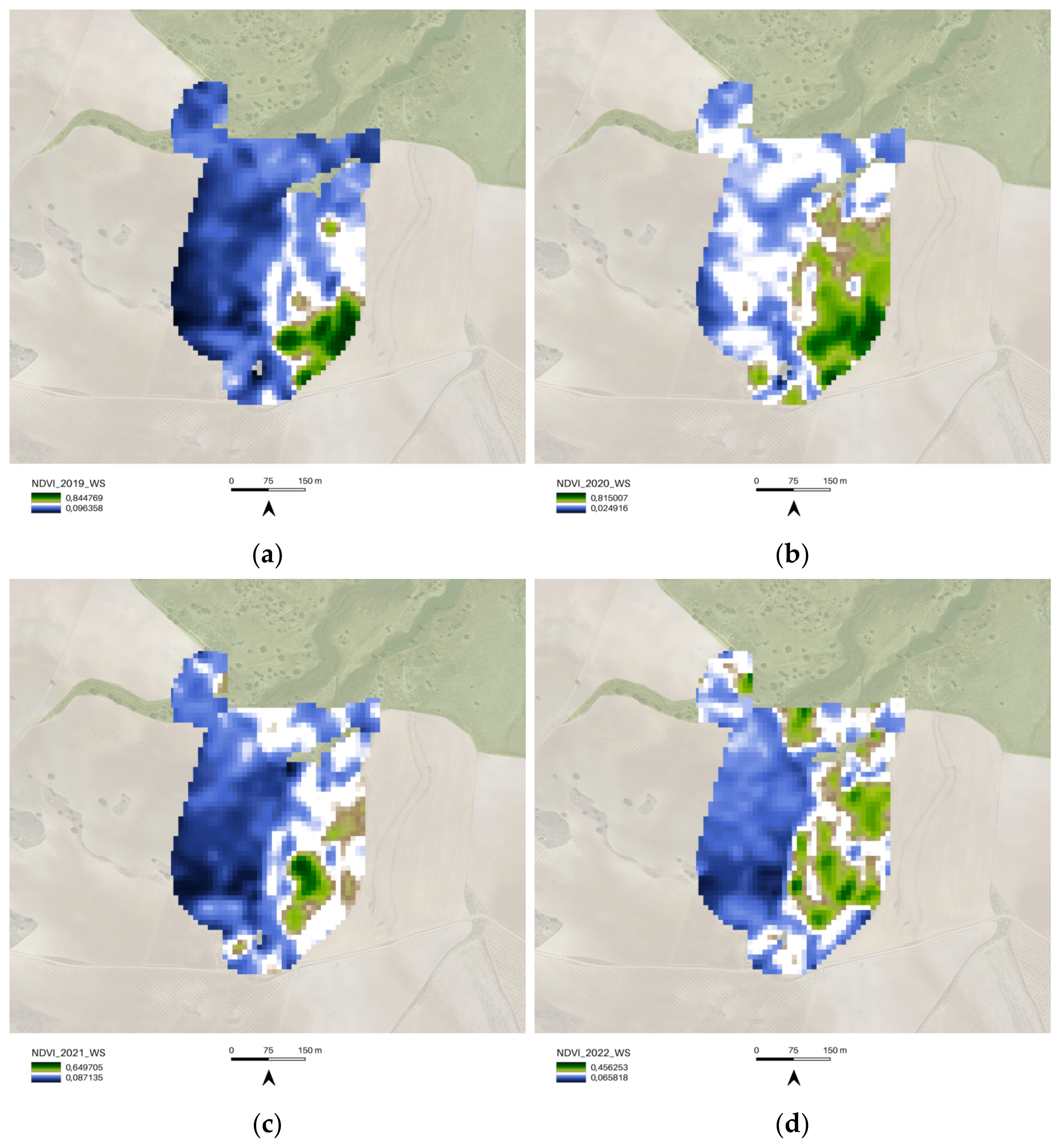
4.3. Phenological Activity of the Plot Areas from the COPERNICUS/S2_SR NDVI (Third Part of the rGEE Code)
5. Discussion
5.1. Considerations of the Methodological Approach
- Fine modulo
5.2. Considerations on the Role of Cloud Computing Platforms (GEE)
5.3. Future Integration of the Results into Restor Platform
6. Conclusions
Author Contributions
Funding
Institutional Review Board Statement
Informed Consent Statement
Data Availability Statement
Acknowledgments
Conflicts of Interest
References
- Cherlet, M.; Hutchinson, C.; Reynolds, J.; Hill, J.; Sommer, S.; Von Maltitz, G. World Atlas of Desertification; Publication Office of the European Union: Luxembourg, 2018; Available online: https://data.europa.eu/doi/10.2760/9205 (accessed on 5 November 2022).
- Prăvălie, R. Exploring the multiple land degradation pathways across the planet. Earth-Sci. Rev. 2021, 220, 103689. [Google Scholar] [CrossRef]
- Prăvălie, R. Drylands extent and environmental issues. A global approach. Earth-Sci. Rev. 2016, 161, 259–278. [Google Scholar] [CrossRef]
- Convention to Combat Desertification (UNCCD) COP 8. Available online: https://www.unccd.int/sites/default/files/sessions/documents/ICCD_COP8_16/16eng.pdf (accessed on 5 November 2022).
- Sustainable Development Goal 15-Life on Land. Available online: https://sdgs.un.org/goals/goal15 (accessed on 4 February 2023).
- COP 21. Available online: https://unfccc.int/event/cop-21 (accessed on 5 November 2022).
- Land Degradation Neutrality (LDN). Available online: https://www.unccd.int/land-and-life/land-degradation-neutrality/overview#:~:text=Land%20Degradation%20Neutrality%20(LDN)%20has,and%20spatial%20scales%20and%20ecosystems (accessed on 5 November 2022).
- Convention to Combat Desertification (UNCCD) COP 13. Available online: https://www.unccd.int/official-documents/cop-13-ordos-china-2017 (accessed on 5 November 2022).
- Ecosystem Restoration Camps. Available online: https://ecosystemrestorationcamps.org/ (accessed on 5 November 2022).
- Convention to Combat Desertification (UNCCD) COP 15. Available online: https://www.unccd.int/official-documents/cop-15-abidjan-cote-divoire-2022 (accessed on 5 November 2022).
- Soil Framework. Available online: https://ecosystemrestorationcamps.org/wp-content/uploads/2022/05/Soil-Framework_v2.0_2022.pdf (accessed on 1 November 2022).
- Aybar, C.; Wu, Q.; Bautista, L.; Yali, R.; Barja, A. rgee: An R package for interacting with Google Earth Engine. J. Open Source Softw. 2020, 5, 2272. [Google Scholar] [CrossRef]
- Gorelick, N.; Hancher, M.; Dixon, M.; Ilyushchenko, S.; Thau, D.; Moore, R. Google Earth Engine: Planetary-scale geospatial analysis for everyone. Remote Sens. Environ. 2017, 202, 18–27. [Google Scholar] [CrossRef]
- Mutanga, O.; Kumar, L. Google earth engine applications. Remote Sens. 2019, 11, 591. [Google Scholar] [CrossRef] [Green Version]
- Tamiminia, H.; Salehi, B.; Mahdianpari, M.; Quackenbush, L.; Adeli, S.; Brisco, B. Google Earth Engine for geo-big data applications: A meta-analysis and systematic review. ISPRS J. Photogramm. Remote Sens. 2020, 164, 152–170. [Google Scholar] [CrossRef]
- Stefanidis, S.; Alexandridis, V.; Mallinis, G. A cloud-based mapping approach for assessing spatiotemporal changes in erosion dynamics due to biotic and abiotic disturbances in a Mediterranean Peri-Urban forest. Catena 2022, 218, 106564. [Google Scholar] [CrossRef]
- Gemitzi, A.; Koutsias, N. A Google Earth Engine code to estimate properties of vegetation phenology in fire affected areas—A case study in North Evia wildfire event on August 2021. Remote Sens. Appl. Soc. Environ. 2022, 26, 100720. [Google Scholar] [CrossRef]
- Maresma, Á.; Ariza, M.; Martínez, E.; Lloveras, J.; Martínez-Casasnovas, J.A. Martínez-Casasnovas. Analysis of vegetation indices to determine nitrogen application and yield prediction in maize (Zea mays L.) from a standard UAV service. Remote Sens. 2016, 8, 973. [Google Scholar] [CrossRef] [Green Version]
- Crego, R.D.; Masolele, M.M.; Connette, G.; Stabach, J.A. Enhancing animal movement analyses: Spatiotemporal matching of animal positions with remotely sensed data using google earth engine and R. Remote Sens. 2021, 13, 4154. [Google Scholar] [CrossRef]
- Hazaymeh, K.; Sahwan, W.; Al Shogoor, S.; Schütt, B. A Remote Sensing-Based Analysis of the Impact of Syrian Crisis on Agricultural Land Abandonment in Yarmouk River Basin. Sensors 2022, 22, 3931. [Google Scholar] [CrossRef]
- Bey, A.; Jetimane, J.; Lisboa, S.N.; Ribeiro, N.; Sitoe, A.; Meyfroidt, P. Mapping smallholder and large-scale cropland dynamics with a flexible classification system and pixel-based composites in an emerging frontier of Mozambique. Remote Sens. Environ. 2020, 239, 111611. [Google Scholar] [CrossRef]
- Elnashar, A.; Zeng, H.; Wu, B.; Gebremicael, T.G.; Marie, K. Assessment of environmentally sensitive areas to desertification in the Blue Nile Basin driven by the MEDALUS-GEE framework. Sci. Total Environ. 2022, 815, 152925. [Google Scholar] [CrossRef]
- Giuliani, G.; Mazzetti, P.; Santoro, M.; Nativi, S.; Van Bemmelen, J.; Colangeli, G.; Lehmann, A. Knowledge generation using satellite earth observations to support sustainable development goals (SDG): A use case on Land degradation. Int. J. Appl. Earth Obs. Geoinf. 2020, 88, 102068. [Google Scholar] [CrossRef]
- Percival Alfred, Y. The Keyline plan. Keyline Plan 1954. Available online: http://yeomansplow.com.au/8-yeomans-keyline-systems-explained/ (accessed on 5 November 2022).
- Rouse, J.W.; Haas, R.H.; Schell, J.A.; Deering, D.W. Monitoring vegetation systems in the Great Plains with ERTS. NASA Spec. Publ. 1974, 351, 309. [Google Scholar]
- Tucker, C.J. Red and photographic infrared linear combinations for monitoring vegetation. Remote Sens. Environ. 1979, 8, 127–150. [Google Scholar] [CrossRef] [Green Version]
- El-Gammal, M.I.; Ali, R.R.; Samra, R.A. NDVI threshold classification for detecting vegetation cover in Damietta governorate, Egypt. J. Am. Sci. 2014, 10, 108–113. [Google Scholar]
- Hein, L.; de Ridder, N.; Hiernaux, P.; Leemans, R.; de Wit, A.; Schaepman, M. Desertification in the Sahel: Towards better accounting for ecosystem dynamics in the interpretation of remote sensing images. J. Arid. Environ. 2011, 75, 1164–1172. [Google Scholar] [CrossRef]
- D’Odorico, P.; Bhattachan, A.; Davis, K.F.; Ravi, S.; Runyan, C.W. Global desertification: Drivers and feedbacks. Adv. Water Resour. 2013, 51, 326–344. [Google Scholar] [CrossRef]
- Masoudi, M. Risk Assessment of Vegetation Degradation Using GIS; Jomo Kenyatta University of Agriculture and Technology: Juja, Kenya, 2018; Available online: http://hdl.handle.net/123456789/4101 (accessed on 5 November 2022).
- Masoudi, M.; Amiri, E. A new model for hazard evaluation of vegetation degradation using DPSIR framework, a case study: Sadra Region, Iran. Pol. J. Ecol. 2015, 63, 1–9. [Google Scholar] [CrossRef]
- D’Emilio, M.; Coluzzi, R.; Macchiato, M.; Imbrenda, V.; Ragosta, M.; Sabia, S.; Simoniello, T. Satellite data and soil magnetic susceptibility measurements for heavy metals monitoring: Findings from Agri Valley (Southern Italy). Environ. Earth Sci. 2018, 77, 1–7. [Google Scholar] [CrossRef]
- Liu, R.; Xiao, L.; Liu, Z.; Dai, J. Quantifying the relative impacts of climate and human activities on vegetation changes at the regional scale. Ecol. Indic. 2018, 93, 91–99. [Google Scholar] [CrossRef]
- Sulla-Menashe, D.; E Woodcock, C.; A Friedl, M. Canadian boreal forest greening and browning trends: An analysis of biogeographic patterns and the relative roles of disturbance versus climate drivers. Environ. Res. Lett. 2018, 13, 014007. [Google Scholar] [CrossRef]
- Kundu, A.; Patel, N.R.; Saha, S.K.; Dutta, D. Desertification in western Rajasthan (India): An assessment using remote sensing derived rain-use efficiency and residual trend methods. Nat. Hazards 2017, 86, 297–313. [Google Scholar] [CrossRef]
- Forkel, M.; Carvalhais, N.; Verbesselt, J.; Mahecha, M.D.; Neigh, C.S.R.; Reichstein, M. Trend change detection in NDVI time series: Effects of inter-annual variability and methodology. Remote Sens. 2013, 5, 2113–2144. [Google Scholar] [CrossRef] [Green Version]
- Karlsen, S.R.; Tolvanen, A.; Kubin, E.; Poikolainen, J.; H⊘Gda, K.A.; Johansen, B.; Danks, F.S.; Aspholm, P.; Wielgolaski, F.E.; Makarova, O. MODIS-NDVI-based mapping of the length of the growing season in northern Fennoscandia. Int. J. Appl. Earth Obs. Geoinf. 2008, 10, 253–266. [Google Scholar] [CrossRef]
- Huete, A.; Didan, K.; Miura, T.; Rodriguez, E.P.; Gao, X.; Ferreira, L.G. Overview of the radiometric and biophysical performance of the MODIS vegetation indices. Remote Sens. Environ. 2002, 83, 195–213. [Google Scholar] [CrossRef]
- Phan, T.N.; Kuch, V.; Lehnert, L.W. Land cover classification using Google Earth Engine and random forest classifier—The role of image composition. Remote Sens. 2020, 12, 2411. [Google Scholar] [CrossRef]
- Jin, Z.; Azzari, G.; You, C.; Di Tommaso, S.; Aston, S.; Burke, M.; Lobell, D.B. Smallholder maize area and yield mapping at national scales with Google Earth Engine. Remote Sens. Environ. 2019, 228, 115–128. [Google Scholar] [CrossRef]
- Gabriele, M.; Brumana, R.; Previtali, M.; Cazzani, A. A combined GIS and remote sensing approach for monitoring climate change-related land degradation to support landscape preservation and planning tools: The Basilicata case study. Appl. Geomat. 2022, 26, 1–36. [Google Scholar] [CrossRef]
- Restor. Available online: https://restor.eco (accessed on 1 November 2022).
- Kim, H.W.; Hwang, K.; Mu, Q.; Lee, S.O.; Choi, M. Validation of MODIS 16 global terrestrial evapotranspiration products in various climates and land cover types in Asia. KSCE J. Civ. Eng. 2012, 16, 229–238. [Google Scholar] [CrossRef]





| Class | Number of Images | Number of Properties | Number of Pixels * | Approximate Size * |
|---|---|---|---|---|
| ee$ImageCollection | 479 | 30 | 41,362,608 | 11.64 TB |
| ID | System: Time_Start | System: Time_End | Number of Bands | Bands Names | Number of Properties | Number of Pixels * | Approximate size * |
|---|---|---|---|---|---|---|---|
| MODIS/006/MOD13Q1/2002_01_01 | 2002-01-01 | 2002-01-17 | 1 | NDVI | 6 | 86,352 | 24.88 GB |
| EPSG (SRID) | Proj4string | Geotransform | Nominal Scale (Meters) | Dimensions | Number ofPixels | Data Type | Approximate size * |
|---|---|---|---|---|---|---|---|
| MODIS Sinusoidal (SR-ORG:6974) | +proj = sinu + lon_0 = 0 +x_0 = 0 + y_0 = 0 + datum = WGS84 +units = m + no_defs | 231,656358263958 0-20015109,353988 0-231,656358263958 10007554,676994 | 231.6564 | 86,352 | 3,350,730 | INT | 24.88 GB |
| Shapefile | Geometry type | Dimension | Bounding box | Projected CRS |
|---|---|---|---|---|
| AOI.shp | POLYGON | XY | xmin: 572808,9 ymin: 4201485 xmax: 572869 ymax: 4201546 | WGS 84/UTM zone 30N |
| Shapefile | Geometry Type | Dimension | Bounding Box | Projected CRS |
|---|---|---|---|---|
| 01_Regenerative_Almonds.shp | POLYGON | XY | 572741,9224055021768436, 4201252,2837546644732356: 572955,4333709812490270, 4201676,1378671433776617 | WGS 84/UTM zone 30N |
| 02_Camp_Altiplano.shp | POLYGON | XY | 572844,5275248248362914, 4201154,5185987595468760: 573123,6144079214427620, 4201574,1868807338178158 | WGS 84/UTM zone 30N |
| 03_Natural_area.shp | POLYGON | XY | 572733,6076018153689802, 4201567,7970581464469433: 573152,8252753842389211, 421807,0266833500936627 | WGS 84/UTM zone 30N |
| Class | Number of Images | Number of Properties | Number of Pixels * | Approximate Size * |
|---|---|---|---|---|
| ee$ImageCollection | 3 | 23 | 231,200,370 | 127.90 GB |
| ID | System: Time_Start | System: Time_End | Number of Bands | Bands Names | Number of Properties | Number of Pixels * | Approximate Size * |
|---|---|---|---|---|---|---|---|
| COPERNICUS/S2_SR/20170409T105651_20170409T110529_T30SWH | 2017-04-09 11:05:29 | 2017-04-09 11:05:29 | 23 | B1 B2 B3 B4 B5 B6 B7 B8 B8A B9 B11 B12 AOT WVP SCL TCI_R TCI_G TCI_B MSK_CLDPRB MSK_SNWPRB QA10 QA20 QA60 | 82 | 77,066,790 | 42.63 GB |
| EPSG (SRID) | Proj4string | Geotransform | Nominal Scale (Meters) | Dimensions | Number of Pixels | Data type | Approximate size * |
|---|---|---|---|---|---|---|---|
| WGS 84/UTM zone 30N (EPSG: 32630) | +proj = utm + zone = 30 + datum = WGS84 + units = m + no_defs | 60 0 499980 0-60 4300020 | 60 | 1831 1830 | 3,350,730 | INT | 1.85 GB |
| Class | Number of Images | Number of Properties | Number of Pixels * | Approximate Size * |
|---|---|---|---|---|
| ee$ImageCollection | 14 | 23 | 794,911,740 | 351.49 GB |
| ID | System: Time_Start | System: Time_End | Number of Bands | Bands Names | Number of Properties | Number of Pixels * | Approximate size * |
|---|---|---|---|---|---|---|---|
| COPERNICUS/S2_SR/20211201T105421_20211201T105655_T30SWH | 2021-12-01 11:00:35 | 2021-12-01 11:00:35 | 23 | B1 B2 B3 B4 B5 B6 B7 B8 B8A B9 B11 B12 AOT WVP SCL TCI_R TCI_G TCI_B MSK_CLDPRB MSK_SNWPRB QA10 QA20 QA60 | 81 | 56,779,410 | 25.11 GB |
| EPSG (SRID) | Proj4string | Geotransform | Nominal Scale (Meters) | Dimensions | Number of Pixels | Data Type | APPROXIMATE Size * |
|---|---|---|---|---|---|---|---|
| WGS 84/UTM zone 30N (EPSG: 32630) | +proj = utm + zone = 30 + datum = WGS84 + units = m + no_defs | 60 0 499980 0-60 4300020 | 60 | 1349 1830 | 2,468,670 | INT | 1.09 GB |
| Year | COPERNICUS/S2_SR SOS Filter Date | COPERNICUS/S2_SR EOS Filter Date |
|---|---|---|
| 2017 | 2017-03-01 | 2017-03-01 |
| 2018 | 2018-03-01 | 2018-05-31 |
| 2019 | 2019-03-01 | 2019-05-31 |
| 2020 | 2020-03-01 | 2020-05-31 |
| 2021 | 2021-03-01 | 2021-05-31 |
| 2022 | 2022-03-01 | 2022-05-31 |
| Year | COPERNICUS/S2_SR WS start Filter Date | COPERNICUS/S2_SR WS end Filter Date |
|---|---|---|
| 2019 | 2018-12-01 | 2019-03-01 |
| 2020 | 2019-12-01 | 2020-03-01 |
| 2021 | 2020-12-01 | 2021-03-01 |
| 2022 | 2021-12-01 | 2022-03-01 |
| Shapefile | Geometry Type | Dimension | Bounding Box | Projected CRS | Feature Count |
|---|---|---|---|---|---|
| 01_REGENERATIVE_ALMONDS_PLOT.shp | POLYGON | XY | 572801,1651063224999234, 4201413,9108924288302660: 572869,0225870141293854, 4201546,0453444486483932 | WGS 84/UTM zone 30N | 1 |
| 02_CAMP_ALTIPLANO_PLOT.shp | POLYGON | XY | 572928,8496651893947273, 4201317,7795310029760003: 573029,3255905595142394, 4201384,1732937581837177 | WGS 84/UTM zone 30N | 1 |
| 03_NATURAL_AREA_PLOT.shp | POLYGON | XY | 572929,5905389715917408, 4201609,3690982637926936: 572989,6686835289001465, 4201670,7823126995936036 | WGS 84/UTM zone 30N | 1 |
Disclaimer/Publisher’s Note: The statements, opinions and data contained in all publications are solely those of the individual author(s) and contributor(s) and not of MDPI and/or the editor(s). MDPI and/or the editor(s) disclaim responsibility for any injury to people or property resulting from any ideas, methods, instructions or products referred to in the content. |
© 2023 by the authors. Licensee MDPI, Basel, Switzerland. This article is an open access article distributed under the terms and conditions of the Creative Commons Attribution (CC BY) license (https://creativecommons.org/licenses/by/4.0/).
Share and Cite
Gabriele, M.; Brumana, R. Monitoring Land Degradation Dynamics to Support Landscape Restoration Actions in Remote Areas of the Mediterranean Basin (Murcia Region, Spain). Sensors 2023, 23, 2947. https://doi.org/10.3390/s23062947
Gabriele M, Brumana R. Monitoring Land Degradation Dynamics to Support Landscape Restoration Actions in Remote Areas of the Mediterranean Basin (Murcia Region, Spain). Sensors. 2023; 23(6):2947. https://doi.org/10.3390/s23062947
Chicago/Turabian StyleGabriele, Marzia, and Raffaella Brumana. 2023. "Monitoring Land Degradation Dynamics to Support Landscape Restoration Actions in Remote Areas of the Mediterranean Basin (Murcia Region, Spain)" Sensors 23, no. 6: 2947. https://doi.org/10.3390/s23062947
APA StyleGabriele, M., & Brumana, R. (2023). Monitoring Land Degradation Dynamics to Support Landscape Restoration Actions in Remote Areas of the Mediterranean Basin (Murcia Region, Spain). Sensors, 23(6), 2947. https://doi.org/10.3390/s23062947


