
Research on Classification of Open-Pit Mineral Exploiting Information Based on OOB RFE Feature Optimization


Abstract
:1. Introduction
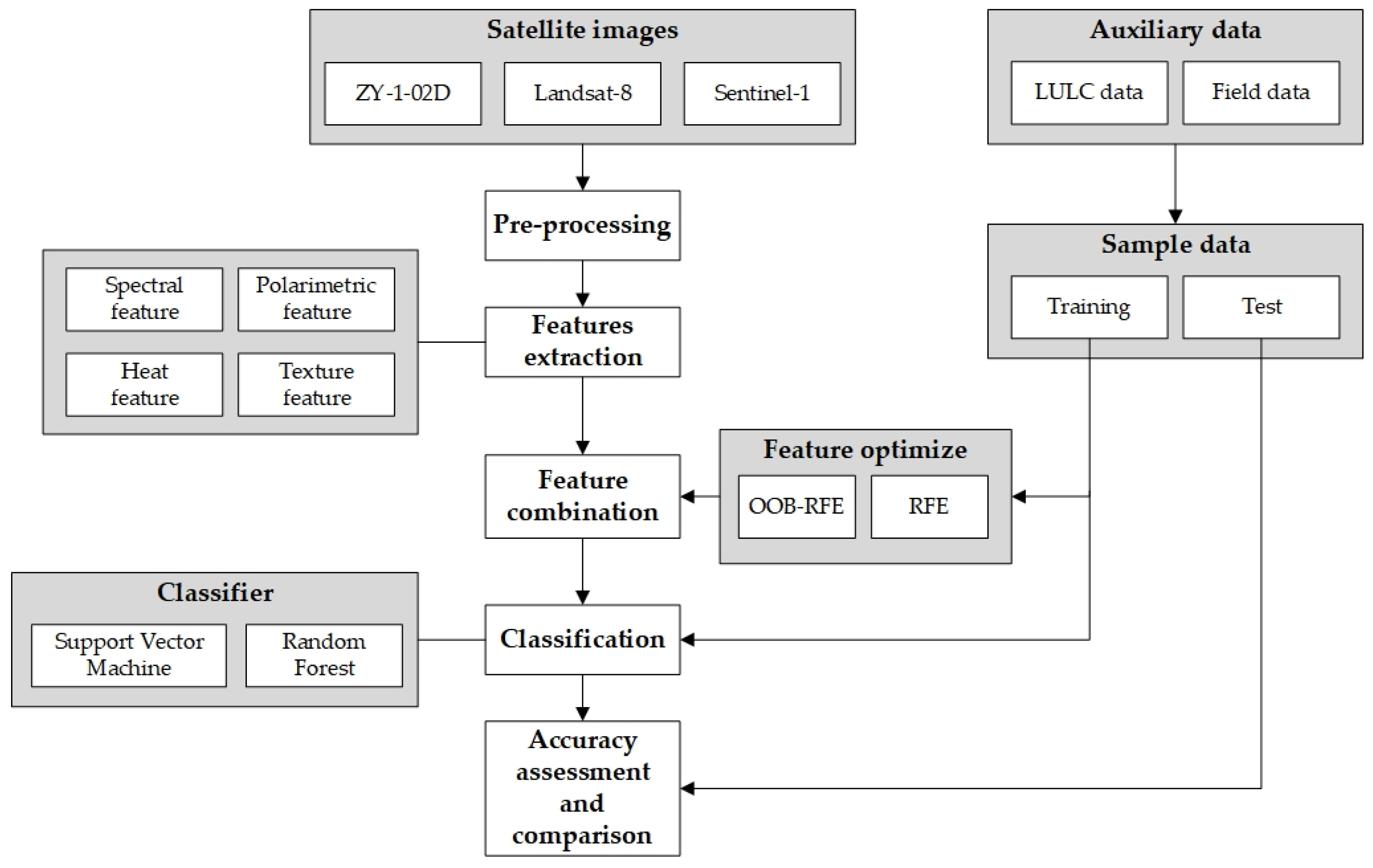
2. Materials and Methods
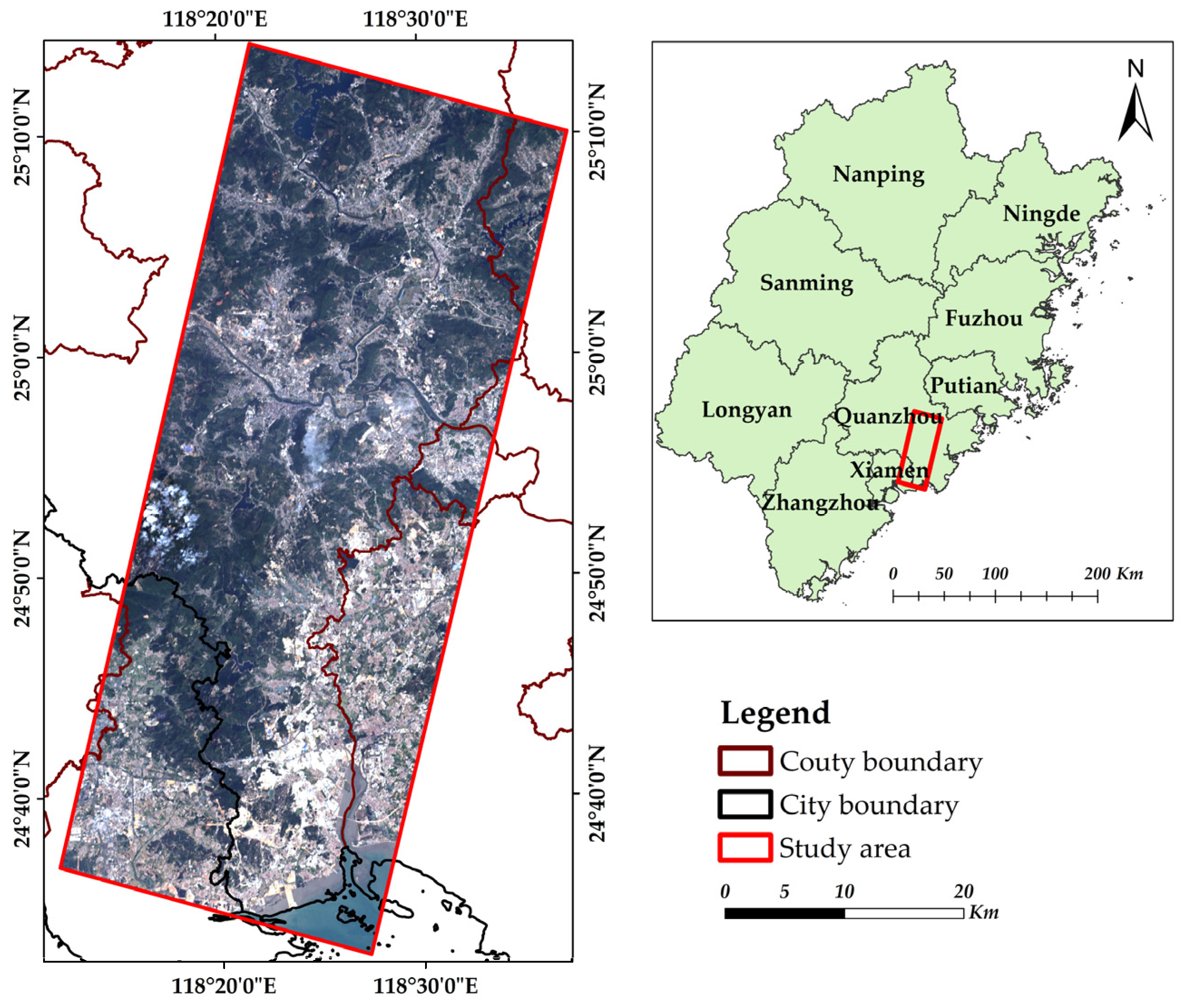
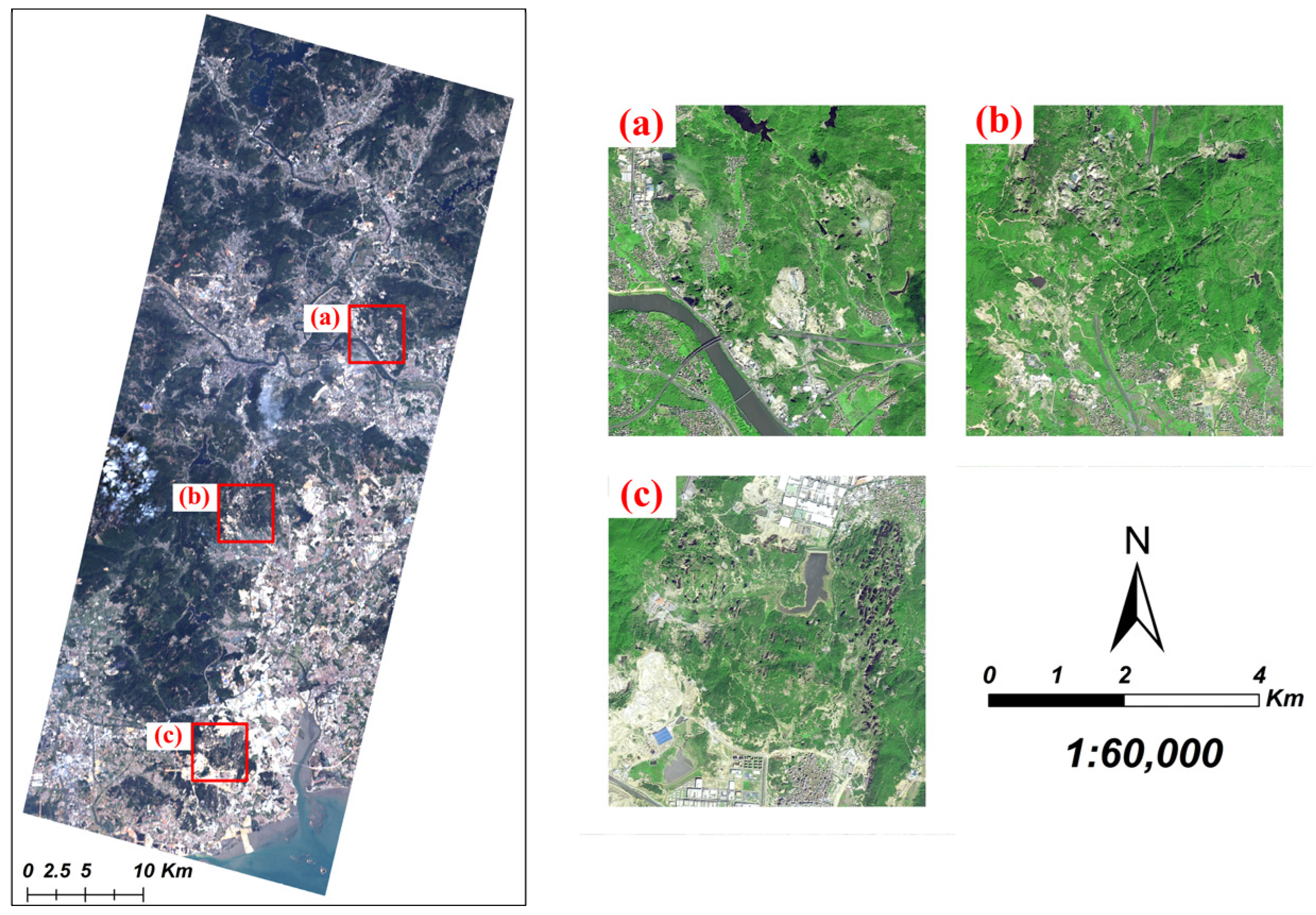
2.1. Study Area
2.2. Data and Preprocessing
2.2.1. Satellite Images
2.2.2. Auxiliary Data
2.2.3. Classification Types
2.2.4. Data Preprocessing
3. Methods
3.1. Feature Extraction
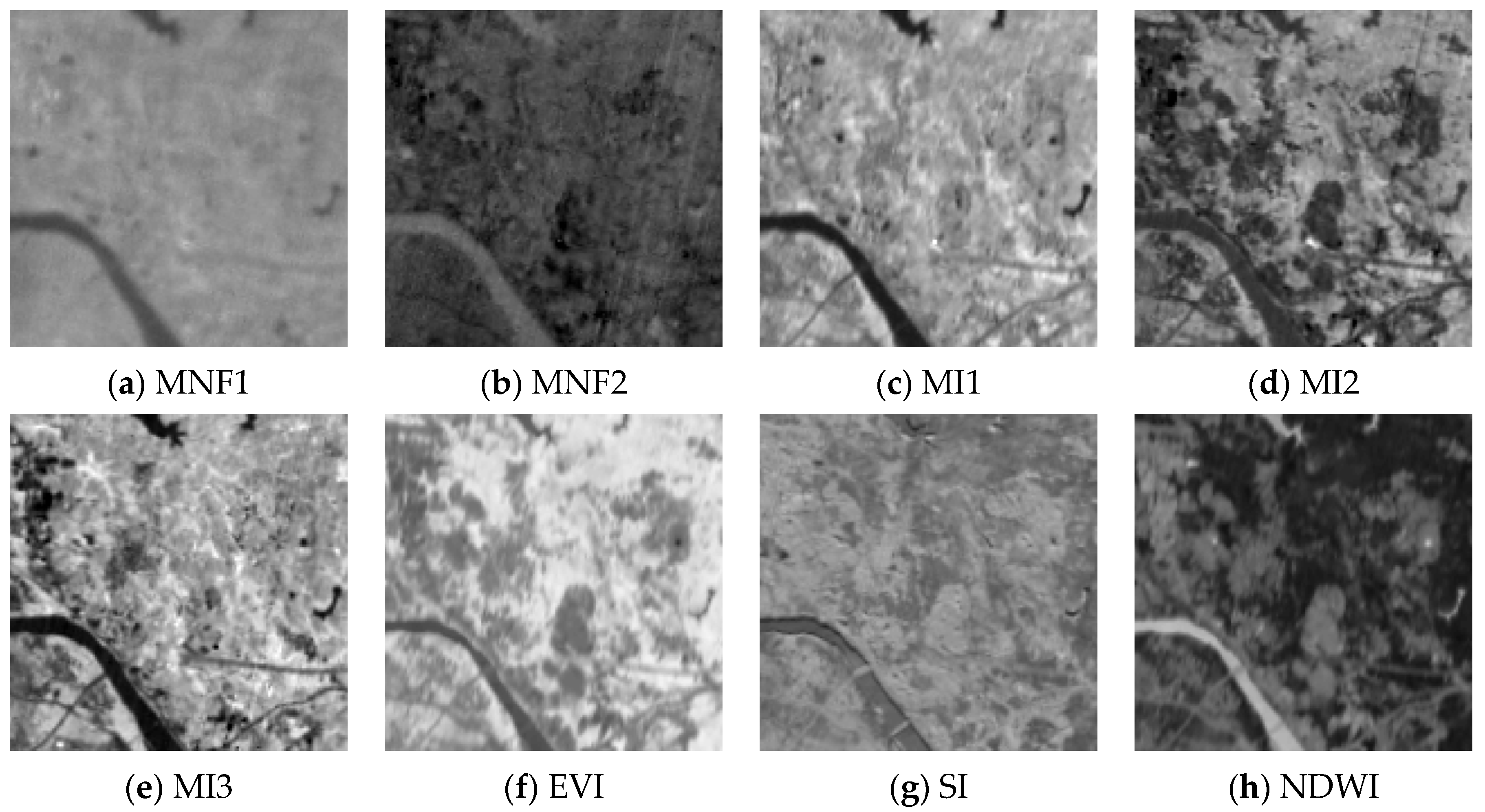
3.1.1. Spectral Feature
Minimum Noise Fraction
Band and Index Feature
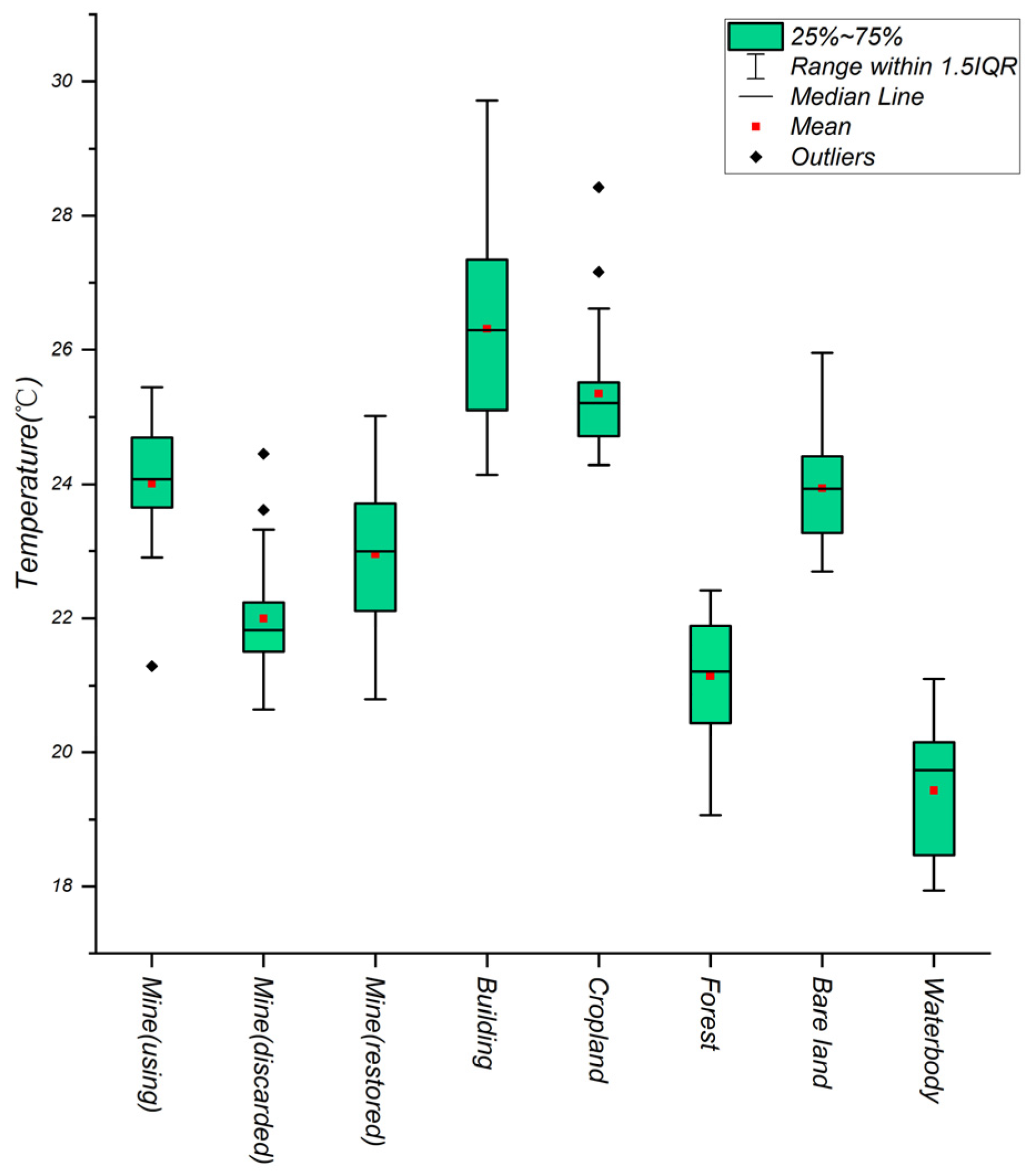
3.1.2. Heat Feature
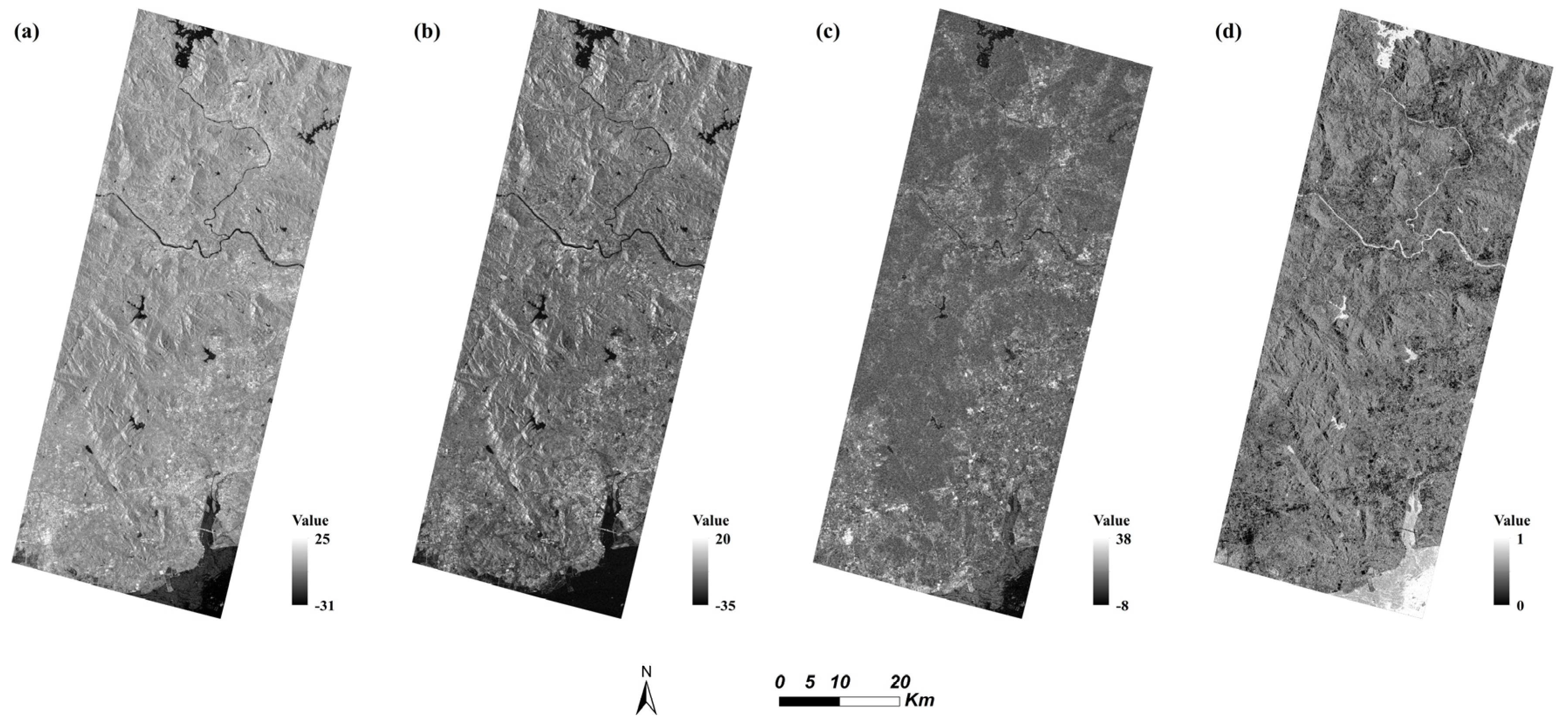
3.1.3. Polarimetric Feature
3.1.4. Texture Feature
3.2. Feature Optimization
3.2.1. Recursive Feature Elimination
- (1)
- Pick an initial feature dataset N with n features and choose a base model for RFE;
- (2)
- Generate feature subset by removing the features with lowest score based on calculation of base model;
- (3)
- Basing on base model, deviation of subset can be testified through cross validation;
- (4)
- Repeat step (2), (3), until the last feature was left over. After comparing every output, the feature subset with smallest deviation can be considered as the optimal feature set.
3.2.2. OOB RFE
- (1)
- Starting with an initial feature dataset N with n features, this study constructs a regression tree using subsets extracted by bootstrap random sampling and gathers the OOB data to form a test sample
- (2)
- According to certain criteria, the optimal branch was chosen from regression tree, which allows the maximum growth of each decision tree
- (3)
- After integrating the regression tree in (1) to build a random forest regression model, we can calculate OOB score and obtain feature importance based on OOB error
- (4)
- According to the principle of backward iteration, we can delete the feature with the smallest feature importance
- (5)
- The whole process (1)–(4) has been repeated over and over until one feature left. After data output, we select the number of features that generates the largest OOB score as the optimal feature number, and select variables based on the feature importance ranking to form the optimal feature combination.
3.3. Feature Combination Scheme
3.4. Classification Algorithm and Samples
3.5. Accuracy Assessment
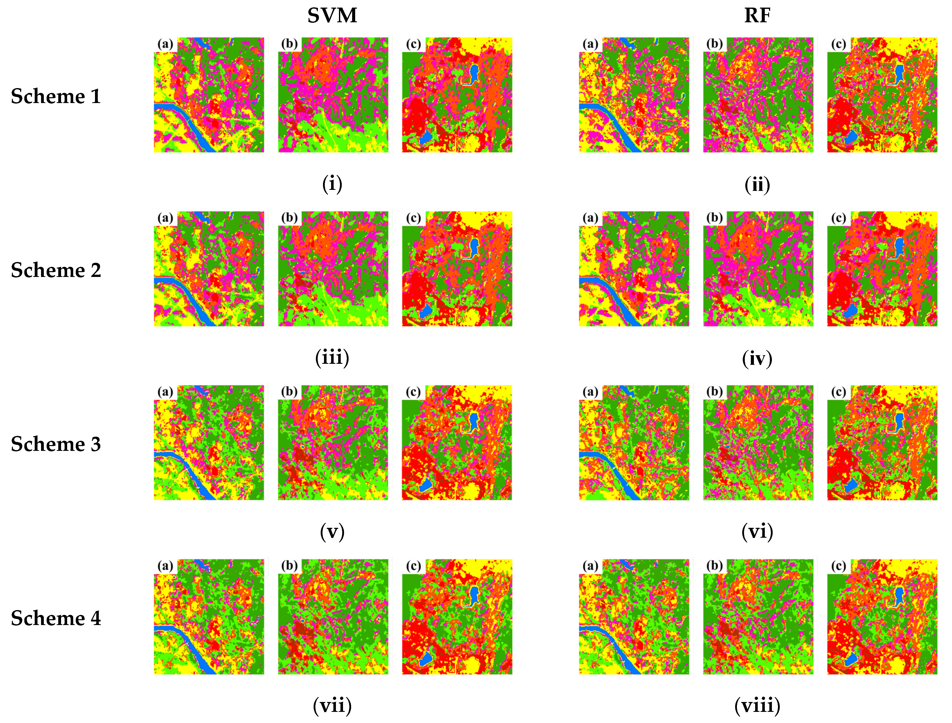
4. Results
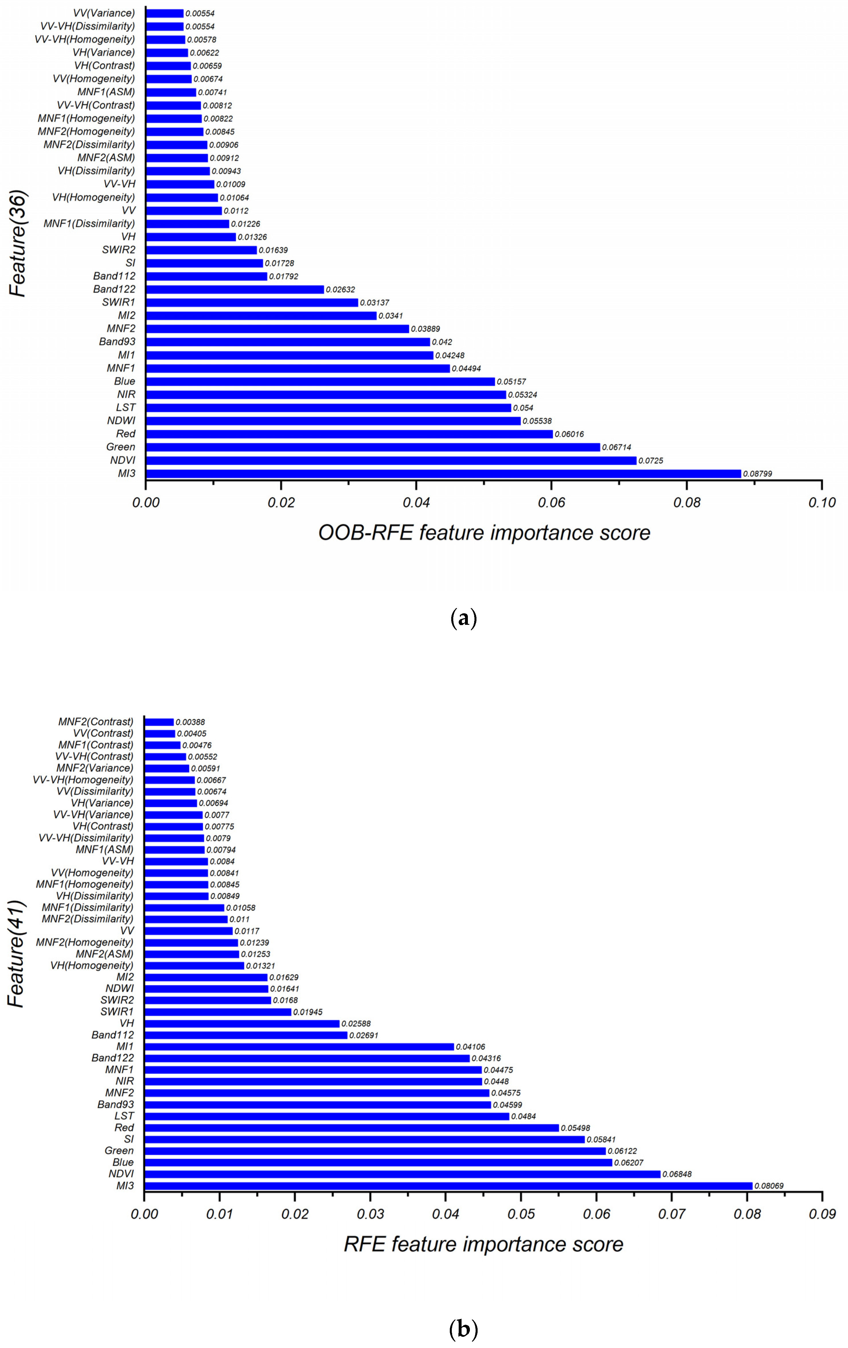
4.1. Optimized Results and Feature Importance
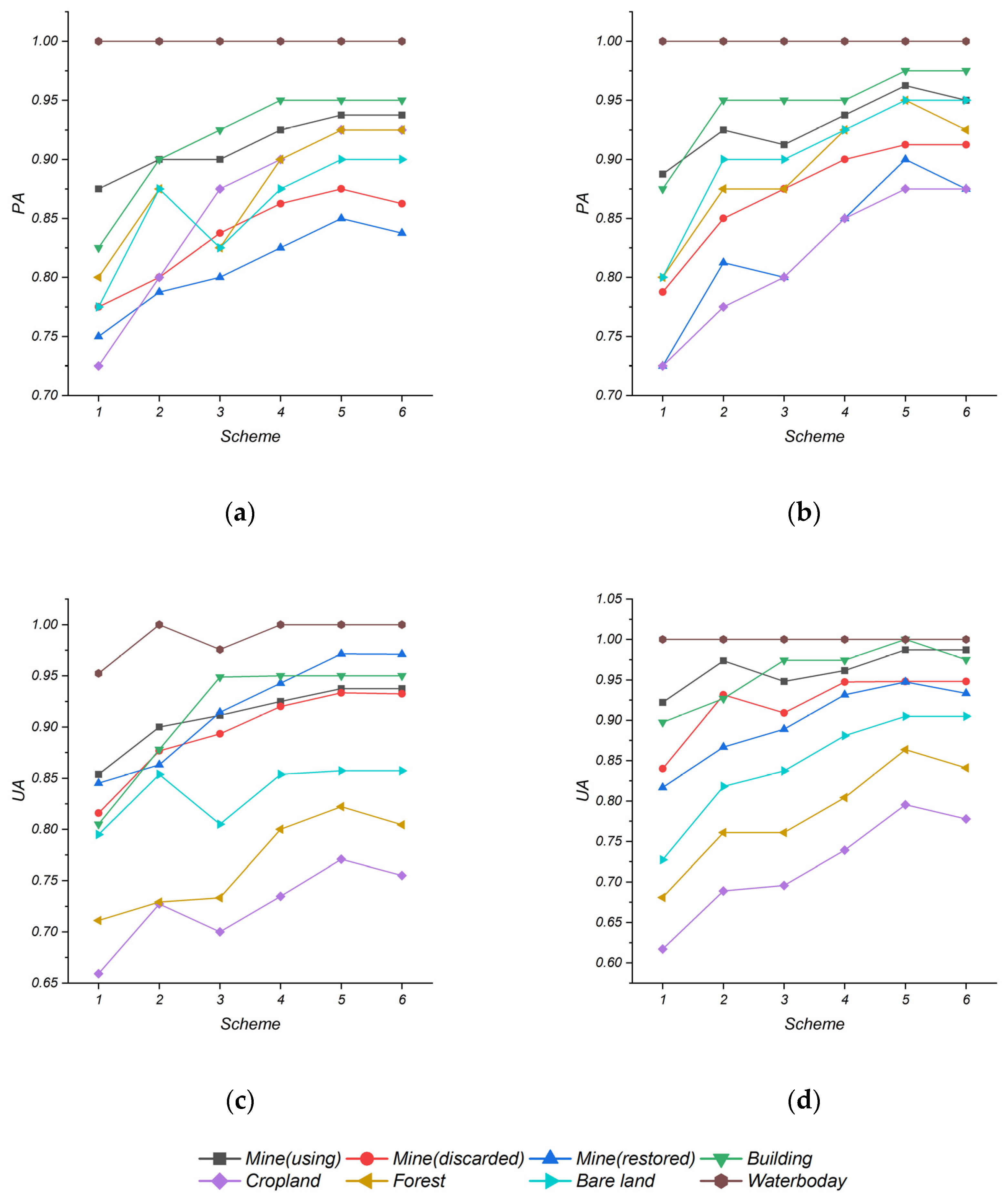
4.2. Accuracy Assessment and Comparison
5. Discussion
6. Conclusions
- In this study, using the traditional RFE algorithm and the OOB RFE method to perform dimensional reduction and feature optimization, we decided the number of features included in optimal combination should be 41 and 36, respectively. It was shown that the average OA of these two classification increase 1.365 and 2.05%, respectively. Also, it was noteworthy that the classification based on OOB RFE method had top performance, as it gained the highest average OA 92.39%. Comparing with traditional RFE method, OOB RFE method could reduce more data redundancy and enhance model generalization ability, so it could make a balance between feature dimension and classification accuracy of mineral exploiting information. In addition, compared with SVM, RF, average OA, of which rises 1.78%, could more accurately distinguish the land boundary of mineral exploiting information and get stronger robustness.
- Among the importance gained by two feature optimization, specifically for the mineral exploiting information in our study, spectral features based on ZY-1-02D showed the highest importance, while features like MI3 and NDVI rank in the second place; and LST gained from Landsat-8 successively ranked in sixth and seventh in two different methods; besides, the importance of other polarization features, like VV, VH from Sentinel-1 got a middle position in our ranking; However, the texture feature had the lowest importance as it ranks 20th among all features.
Author Contributions
Funding
Acknowledgments
Conflicts of Interest
References
- Dai, X.; Li, Z.; Lin, S.; Xu, W. Assessment and zoning of eco-environmental sensitivity for a typical developing province in China. Stoch. Environ. Res. Risk Assess. 2012, 26, 1095–1107. [Google Scholar] [CrossRef]
- Yang, Z.; Li, W.; Li, X.; Wang, Q.; He, J. Assessment of eco-geo-environment quality using multivariate data: A case study in a coal mining area of Western China. Ecol. Indic. 2019, 107, 105651. [Google Scholar] [CrossRef]
- Song, W.; Song, W.; Gu, H.; Li, F. Progress in the remote sensing monitoring of the ecological environment in mining areas. Int. J. Environ. Res. Public Health 2020, 17, 1846. [Google Scholar] [CrossRef] [PubMed] [Green Version]
- Li, Q.; Zhang, W.; Wang, D. Current status, challenges and policy recommendations regarding the sustainable development of mining areas in China. J. Resour. Ecol. 2014, 5, 42–52. [Google Scholar]
- Hinzman, L.D.; Bettez, N.D.; Bolton, W.R.; Chapin, F.S.; Dyurgerov, M.B.; Fastie, C.L.; Griffith, B.; Hollister, R.D.; Hope, A.; Huntington, H.P.; et al. Evidence and implications of recent climate change in northern Alaska and other arctic regions. Clim. Chang. 2005, 72, 251–298. [Google Scholar] [CrossRef]
- Otterman, J.; Lowman, P.D.; Salomonson, V.V. Surveying earth resources by remote sensing from satellites. Geophys. Surv. 1976, 2, 431–467. [Google Scholar] [CrossRef]
- Yang, J.; Nie, H.; Jing, Q. Preliminary analysis of mine geo-environment status and existing problems in China. Remote Sens. Land Resour. 2017, 2, 1–7. [Google Scholar]
- De Lucia Lobo, F.; Souza-Filho, P.W.M.; De Moraes Novo, E.M.L.; Menino Carlos, F.; Faria Barbosa, C.C. Mapping mining areas in the Brazilian amazon using MSI/Sentinel-2 imagery (2017). Remote Sens. 2018, 10, 1178. [Google Scholar] [CrossRef] [Green Version]
- Xie, L.; Wu, W.; Huang, X.; Ou, P.; Lin, Z.; Wang, Z.; Song, Y.; Lang, T.; Huangfu, W.; Zhang, Y.; et al. Mining and restoration monitoring of rare earth element (REE) exploitation by new remote sensing indicators in southern Jiangxi, China. Remote Sens. 2020, 12, 3558. [Google Scholar] [CrossRef]
- Hengkai, L.; Feng, X.; Qin, L. Remote sensing monitoring of land damage and restoration in rare earth mining areas in 6 counties in southern Jiangxi based on multisource sequential images. J. Environ. Manag. 2020, 267, 110653. [Google Scholar] [CrossRef]
- Song, L.; Liu, S.; Yu, M.; Mao, Y.; Wu, L. A classification method based on the combination of visible, Near-Infrared and thermal infrared spectrum for coal and gangue distinguishment. Guang Pu Xue Yu Guang Pu Fen Xi/Guang Pu 2017, 37, 416–422. [Google Scholar] [PubMed]
- Chen, W.; Li, X.; He, H.; Wang, L. A review of Fine-Scale land use and land cover classification in Open-Pit mining areas by remote sensing techniques. Remote Sens. 2018, 10, 15. [Google Scholar] [CrossRef] [Green Version]
- Du, P.; Yuan, L.; Xia, J.; He, J. Fusion and classification of Beijing-1 small satellite remote sensing image for land cover monitoring in mining area. Chin. Geogr. Sci. 2011, 21, 656–665. [Google Scholar] [CrossRef]
- Maxwell, A.E.; Warner, T.A.; Strager, M.P.; Pal, M. Combining rapid eye satellite imagery and lidar for mapping of mining and mine reclamation. Photogramm. Eng. Remote Sens. 2014, 80, 179–189. [Google Scholar] [CrossRef]
- Lajeunesse Connette, K.J.; Connette, G.; Bernd, A.; Phyo, P.; Aung, K.H.; Tun, Y.L.; Thein, Z.M.; Horning, N.; Leimgruber, P.; Songer, M.; et al. Assessment of mining extent and expansion in myanmar based on Freely-Available satellite imagery. Remote Sens. 2016, 8, 912. [Google Scholar] [CrossRef] [Green Version]
- Song, X.; He, G.; Zhang, Z.; Long, T.; Peng, Y.; Wang, Z. Visual attention model based mining area recognition on massive high-resolution remote sensing images. Clust. Comput. 2015, 18, 541–548. [Google Scholar] [CrossRef]
- Bu, X.; Bu, L.; Wu, W.; Chang, S. Feasibility Research of PolSAR Data on Mine Remote Sensing Monitoring. Geomat. Spat. Inf. Technol. 2016, 39, 46–50. [Google Scholar]
- Fu, P.; Weng, Q. A time series analysis of urbanization induced land use and land cover change and its impact on land surface temperature with Landsat imagery. Remote Sens. Environ. 2016, 175, 205–214. [Google Scholar] [CrossRef]
- Estoque, R.C.; Murayama, Y. Monitoring surface urban heat island formation in a tropical mountain city using Landsat data (1987-2015). ISPRS J. Photogramm. Remote Sens. 2017, 133, 18–29. [Google Scholar] [CrossRef]
- Hu, J.; Ghamisi, P.; Schmitt, A.; Zhu, X.X. Object based fusion of polarimetric SAR and hyperspectral imaging for land use classification. In Proceedings of the 8th Workshop on Hyperspectral Image and Signal Processing: Evolution in Remote Sensing (WHISPERS), Los Angeles, CA, USA, 21–24 August 2016. [Google Scholar]
- Chen, Y.; Tian, S. Comparison of pixel- and object-based image analysis for tea plantation mapping using hyperspectral Gaofen-5 and synthetic aperture radar data. J. Appl. Remote Sens. 2020, 14, 044516. [Google Scholar] [CrossRef]
- Wang, X.; Guo, Y.; He, J.; Du, L. Fusion of HJ1B and ALOS PALSAR data for land cover classification using machine learning methods. Int. J. Appl. Earth Obs. Geoinf. 2016, 52, 192–203. [Google Scholar] [CrossRef]
- Dubeau, P.; King, D.J.; Unbushe, D.G.; Rebelo, L. Mapping the Dabus Wetlands, Ethiopia, using random forest classification of landsat, PALSAR and topographic data. Remote Sens. 2017, 9, 1056. [Google Scholar] [CrossRef] [Green Version]
- Eisavi, V.; Homayouni, S.; Yazdi, A.M.; Alimohammadi, A. Land cover mapping based on random forest classification of multitemporal spectral and thermal images. Environ. Monit. Assess. 2015, 187, 291. [Google Scholar] [CrossRef] [PubMed]
- Lin, X.; Li, C.; Zhang, Y.; Su, B.; Fan, M.; Wei, H. Selecting feature subsets based on SVM-RFE and the overlapping ratio with applications in bioinformatics. Molecules 2018, 23, 52. [Google Scholar] [CrossRef] [Green Version]
- Zhou, X.; Wen, H.; Zhang, Y.; Xu, J.; Zhang, W. Landslide susceptibility mapping using hybrid random forest with GeoDetector and RFE for factor optimization. Geosci. Front. 2021, 12, 101211. [Google Scholar] [CrossRef]
- Liu, H.; Zhang, Y. Selection of Landsat8 Image Classification Bands Based on MLC-RFE. J. Indian Soc. Remote Sens. 2019, 47, 439–446. [Google Scholar] [CrossRef]
- Liu, H.; An, H. Preliminary tests on the performance of MLC-RFE and SVM-RFE in Lansat-8 image classification. Arab. J. Geosci. 2020, 13, 130. [Google Scholar] [CrossRef]
- Demircioğlu, A. Measuring the bias of incorrect application of feature selection when using cross-validation in radiomics. Insights Imaging 2021, 12, 172. [Google Scholar] [CrossRef]
- Chen, B.; Huang, B.; Xu, B. Multi-source remotely sensed data fusion for improving land cover classification. ISPRS J. Photogramm. Remote Sens. 2017, 124, 27–39. [Google Scholar] [CrossRef]
- Rapinel, S.; Hubert-Moy, L.; Clément, B. Combined use of LiDAR data and multispectral earth observation imagery for wetland habitat mapping. Int. J. Appl. Earth Obs. Geoinf. 2015, 37, 56–64. [Google Scholar] [CrossRef]
- Zhou, Y.; Liu, Y.; Tian, S. Water Transparency Retrieval Based on Hyperspectral Data of ZY-1-02D Satellite. Spacecr. Eng. 2020, 29, 155–161. [Google Scholar]
- Alam, S.M.R.; Hossain, M.S. A Rule-Based classification method for mapping saltmarsh Land-Cover in South-Eastern Bangladesh from landsat-8 OLI. Can. J. Remote Sens. 2021, 47, 356–380. [Google Scholar] [CrossRef]
- Dostálová, A. European Wide Forest Classification Based on Sentinel-1 Data. Remote Sens. 2021, 13, 337. [Google Scholar] [CrossRef]
- Bhardwaj, K.; Patra, S. An unsupervised technique for optimal feature selection in attribute profiles for spectral_spatial classification of hyperspectral images. ISPRS J. Photogramm. Remote Sens. 2018, 138, 139–150. [Google Scholar] [CrossRef]
- Gao, L.; Zhao, B.; Jia, X.; Liao, W.; Zhang, B. Optimized kernel minimum noise fraction transformation for hyperspectral image classification. Remote Sens. 2017, 9, 548. [Google Scholar] [CrossRef] [Green Version]
- Liu, Y.; Xiao, C.C. Water extraction on the hyperspectral images of gaofen-5 satellite using spectral indices. Int. Arch. Photogramm. Remote Sens. Spat. Inf. Sci. 2020, 43, 441–446. [Google Scholar] [CrossRef]
- Nepita-Villanueva, M.R.; Berlanga-Robles, C.A.; Ruiz-Luna, A.; Morales Barcenas, J.H. Spatio-temporal mangrove canopy variation (2001-2016) assessed using the MODIS enhanced vegetation index (EVI). J. Coast. Conserv. 2019, 23, 589–597. [Google Scholar] [CrossRef]
- Xu, H.; Wang, Y.; Guan, H.; Shi, T.; Hu, X. Detecting ecological changes with a remote sensing based ecological index (RSEI) produced time series and change vector analysis. Remote Sens. 2019, 11, 2345. [Google Scholar] [CrossRef] [Green Version]
- Malik, M.S.; Shukla, J.P.; Mishra, S. Relationship of LST, NDBI and NDVI using landsat-8 data in Kandaihimmat watershed, Hoshangabad, India. Indian J. Geo Mar. Sci. 2019, 48, 25–31. [Google Scholar]
- Chejarla, V.; Maheshuni, P.; Mandla, V. Quantification of LST and CO2 levels using Landsat-8 thermal bands on urban environment. Geocarto Int. 2016, 31, 913–926. [Google Scholar] [CrossRef]
- Garcia-Santos, V.; Cuxart, J.; Martinez-Villagrasa, D.; Jimenez, M.A.; Simo, G. Comparison of three methods for estimating land surface temperature from landsat 8-TIRS sensor data. Remote Sens. 2018, 10, 1450. [Google Scholar] [CrossRef] [Green Version]
- Chen, Y.J.; Tian, S.F. Feature-Level fusion between gaofen-5 and Sentinel-1A data for tea plantation mapping. Forests 2020, 11, 1357. [Google Scholar] [CrossRef]
- Fu, B.; Wang, Y.; Campbell, A.; Li, Y.; Zhang, B.; Yin, S.; Xing, Z.; Jin, X. Comparison of object-based and pixel-based Random Forest algorithm for wetland vegetation mapping using high spatial resolution GF-1 and SAR data. Ecol. Indic. 2017, 73, 105–117. [Google Scholar] [CrossRef]
- Lacombe, T.; Favrelière, H.; Pillet, M. Modal features for image texture classification. Pattern Recogn. Lett. 2020, 135, 249–255. [Google Scholar] [CrossRef]
- Chen, Q.; Meng, Z.; Liu, X.; Jin, Q.; Su, R. Decision variants for the automatic determination of optimal feature subset in RF-RFE. Genes 2018, 9, 301. [Google Scholar] [CrossRef] [Green Version]
- Chang, W.; Ji, X.; Wang, L.; Liu, H.; Zhang, Y.; Chen, B.; Zhou, S. A Machine-Learning method of predicting vital capacity plateau value for ventilatory pump failure based on data mining. Healthcare 2021, 9, 1306. [Google Scholar] [CrossRef]
- Liang, J.; Zheng, Z.; Xia, S.; Zhang, X.; Tang, Y. Crop recognition and evaluationusing red edge features of GF-6 satellite. Yaogan Xuebao/J. Remote Sens. 2020, 24, 1168–1179. [Google Scholar]
- Shim, M.; Lee, S.; Hwang, H. Inflated prediction accuracy of neuropsychiatric biomarkers caused by data leakage in feature selection. Sci. Rep. 2021, 11, 7980. [Google Scholar] [CrossRef]
- Cawley, G.C.; Talbot, N.L.C. On over-fitting in model selection and subsequent selection bias in performance evaluation. J. Mach. Learn. Res. 2010, 11, 2079–2107. [Google Scholar]
- Khan, Z.; Gul, N.; Faiz, N.; Gul, A.; Adler, W.; Lausen, B. Optimal Trees Selection for Classification via Out-of-Bag Assessment and Sub-Bagging. IEEE Access 2021, 9, 28591–28607. [Google Scholar] [CrossRef]
- Li, H.; Wang, L.; Xiao, S. Random forest classification of land use in hilly and mountaineous areas of southern China using multi-source remote sensing data. Nongye Gongcheng Xuebao/Trans. Chin. Soc. Agric. Eng. 2021, 37, 244–251. [Google Scholar]
- Huang, C.; Zhang, C.; Liu, Q.; Li, H.; Yang, X.; Liu, G. Multi-Feature classification of optical and SAR remote sensing images for typical tropical plantation species. Sci. Silvae Sin. 2021, 57, 80–91. [Google Scholar]
- Wang, F.; Zhou, K.; Wang, M.; Wang, Q. The impact analysis of land features to JL1-3B nighttime light data at parcel level: Illustrated by the case of Changchun, China. Sensors 2020, 20, 5447. [Google Scholar] [CrossRef] [PubMed]
- Yao, R.; Li, J.; Hui, M.; Bai, L.; Wu, Q. Feature selection based on random forest for partial discharges characteristic set. IEEE Access 2020, 8, 159151–159161. [Google Scholar] [CrossRef]
- Shao, Y.; Lunetta, R.S. Comparison of support vector machine, neural network, and CART algorithms for the land-cover classification using limited training data points. ISPRS J. Photogramm. Remote Sens. 2012, 70, 78–87. [Google Scholar] [CrossRef]
- Liu, X.; Li, Y. Research on Classification Method of Medium Resolution Remote Sensing Image Based on Machine Learning. Spat. Data Intell. 2021, 12753, 164–173. [Google Scholar]
- Liu, X.; Song, W.; Yu, J.; Zhang, X.; Zhao, L.; Wang, A. Remote sensing image classification algorithm based on texture feature and extreme learning machine. Comput. Mater. Contin. 2020, 65, 1385–1395. [Google Scholar] [CrossRef]
- Wan, Y.; Li, C.; Zhao, X.; Liu, B. Optical remote sensing image classification and evaluation based on SVM. J. Geomat. 2018, 43, 74–77. [Google Scholar]
- Kimes, D.S.; Manry, M.T.; Nelson, R.F.; Fung, A.K. Review Article: Attributes of neural networks for extracting continuous vegetation variables from optical and radar measurements. Int. J. Remote Sens. 1998, 19, 2639–2663. [Google Scholar] [CrossRef]
- Sheykhmousa, M.; Mahdianpari, M.; Ghanbari, H.; Mohammadimanesh, F.; Ghamisi, P.; Homayouni, S. Support vector machine versus random forest for remote sensing image classification: A Meta-Analysis and systematic review. IEEE J. Sel. Top. Appl. Earth Obs. Remote Sens. 2020, 13, 6308–6325. [Google Scholar] [CrossRef]
- Amoakoh, A.O.; Aplin, P.; Awuah, K.T.; Delgado-Fernandez, I.; Moses, C.; Alonso, C.P.; Kankam, S.; Mensah, J.C. Testing the contribution of Multi-Source remote sensing features for random forest classification of the greater amanzule tropical peatland. Sensors 2021, 21, 3399. [Google Scholar] [CrossRef] [PubMed]
- Tavares, P.A.; Beltrão, N.E.S.; Guimarães, U.S.; Teodoro, A.C. Integration of sentinel-1 and sentinel-2 for classification and LULC mapping in the urban area of Belém, eastern Brazilian Amazon. Sensors 2019, 19, 1140. [Google Scholar] [CrossRef] [PubMed] [Green Version]
- Nascimento, F.S.; Gastauer, M.; Souza-Filho, P.W.M.; Nascimento, W.R.; Santos, D.C.; Costa, M.F. Land cover changes in Open-Cast mining complexes based on High-Resolution remote sensing data. Remote Sens. 2020, 12, 611. [Google Scholar] [CrossRef] [Green Version]
- Bao, N.; Li, W.; Gu, X.; Liu, Y. Biomass estimation for semiarid vegetation and mine rehabilitation using worldview-3 and sentinel-1 SAR imagery. Remote Sens. 2019, 11, 2855. [Google Scholar] [CrossRef] [Green Version]


| Data | ZY-1-02D | Landsat-8 | Sentinel-1 |
|---|---|---|---|
| Spatial resolution (m) | 30 | Operational land imager: 30 (Panchromatic band: 15) Thermal infrared Sensor: 100 | Ground Range Detected (GRD): 20 × 22 |
| Bands information | Visible~near infrared (0.40–1.04 µm): 76 bands Short wave infrared (1.00–2.50 µm): 90 bands | Visible~Short wave infrared (0.40–2.29 µm): 9 bands (include 1 panchromatic band) Thermal infrared (10.6–12.51 µm): 2 bands | Dual VV + VH polarization * |
| Acquisition date | 16 March 2020 | 16 March 2020 | 17 March 2020 |
| Cloud cover | 3% | 1.3% | - |
| Band Feature | Related Bands’ Wavelength of ZY-1-02D (nm) | Landsat-8 OLI Wavelength Width (µm) |
|---|---|---|
| Blue | 455, 464, 473, 481, 490, 499, 507 | 0.45–0.51 |
| Green | 533, 542, 550, 559, 567, 576, 585 | 0.53–0.59 |
| Red | 645, 653, 662, 670 | 0.64–0.67 |
| NIR | 851, 859, 868, 876 | 0.85–0.88 |
| SWIR1 | 1576, 1593, 1610, 1627, 1644 | 1.57–1.65 |
| SWIR2 | 2115, 2132, 2148, 2165, 2182, 2199, 2216, 2233, 2249, 2266, 2283 | 2.11–2.29 |
| Index Name | Calculation Formula |
|---|---|
| Enhanced Vegetation Index (EVI) | |
| Soil Index (SI) | |
| Normalized Difference Water Index (NDWI) |
| Scheme | Layers |
|---|---|
| 1 | ZY-1-02D: 2 MNF, 15 band-index features, 10 textures. |
| 2 | Scheme 1, Landsat-8: 1 LST. |
| 3 | Scheme 1, Sentinel-1: 4 Polarimetric features, 20 textures. |
| 4 | Intersection of Scheme 2 and Scheme 3. |
| 5 | OOB RFE combination based on Scheme 4. |
| 6 | RFE combination based on Scheme 4. |
| Support Vector Machine (SVM) | Kernel Type | Gamma | Penalty Parameter | Pyramid Levels | ||||
| Radial basis function | 1/Nvar * | 100 | 0 | |||||
| Random Forest (RF) | Number of Trees | Number of Features | Impurity function | Min Node Samples | Min Impurity | |||
| 100 | Square Root | Gini coefficient | 1 | 0 | ||||
| NO. | Types | Quantities of Samples | ||
|---|---|---|---|---|
| Training | Test | |||
| 1 | Mines | Using | 120 | 80 |
| 2 | Discarded | 120 | 80 | |
| 3 | Restored | 120 | 80 | |
| 4 | Buildings | 60 | 40 | |
| 5 | Croplands | 60 | 40 | |
| 6 | Forests | 60 | 40 | |
| 7 | Bare lands | 60 | 40 | |
| 8 | Water bodies | 60 | 40 | |
| SVM | RF | |||
|---|---|---|---|---|
| OA | Kappa | OA | Kappa | |
| Scheme 1 | 81.14% | 0.781 | 81.82% | 0.789 |
| Scheme 2 | 85.68% | 0.834 | 87.95% | 0.860 |
| Scheme 3 | 86.59% | 0.844 | 88.18% | 0.863 |
| Scheme 4 | 89.55% | 0.878 | 91.14% | 0.897 |
| Scheme 5 | 91.14% | 0.897 | 93.64% | 0.926 |
| Scheme 6 | 90.68% | 0.892 | 92.73% | 0.915 |
Publisher’s Note: MDPI stays neutral with regard to jurisdictional claims in published maps and institutional affiliations. |
© 2022 by the authors. Licensee MDPI, Basel, Switzerland. This article is an open access article distributed under the terms and conditions of the Creative Commons Attribution (CC BY) license (https://creativecommons.org/licenses/by/4.0/).
Share and Cite
Zhou, Y.; Tian, S.; Chen, J.; Liu, Y.; Li, C. Research on Classification of Open-Pit Mineral Exploiting Information Based on OOB RFE Feature Optimization. Sensors 2022, 22, 1948. https://doi.org/10.3390/s22051948
Zhou Y, Tian S, Chen J, Liu Y, Li C. Research on Classification of Open-Pit Mineral Exploiting Information Based on OOB RFE Feature Optimization. Sensors. 2022; 22(5):1948. https://doi.org/10.3390/s22051948
Chicago/Turabian StyleZhou, Yi, Shufang Tian, Jianping Chen, Yao Liu, and Chaozhu Li. 2022. "Research on Classification of Open-Pit Mineral Exploiting Information Based on OOB RFE Feature Optimization" Sensors 22, no. 5: 1948. https://doi.org/10.3390/s22051948
APA StyleZhou, Y., Tian, S., Chen, J., Liu, Y., & Li, C. (2022). Research on Classification of Open-Pit Mineral Exploiting Information Based on OOB RFE Feature Optimization. Sensors, 22(5), 1948. https://doi.org/10.3390/s22051948