
Evaluation of Static Autonomous GNSS Positioning Accuracy Using Single-, Dual-, and Tri-Frequency Smartphones in Forest Canopy Environments


Abstract
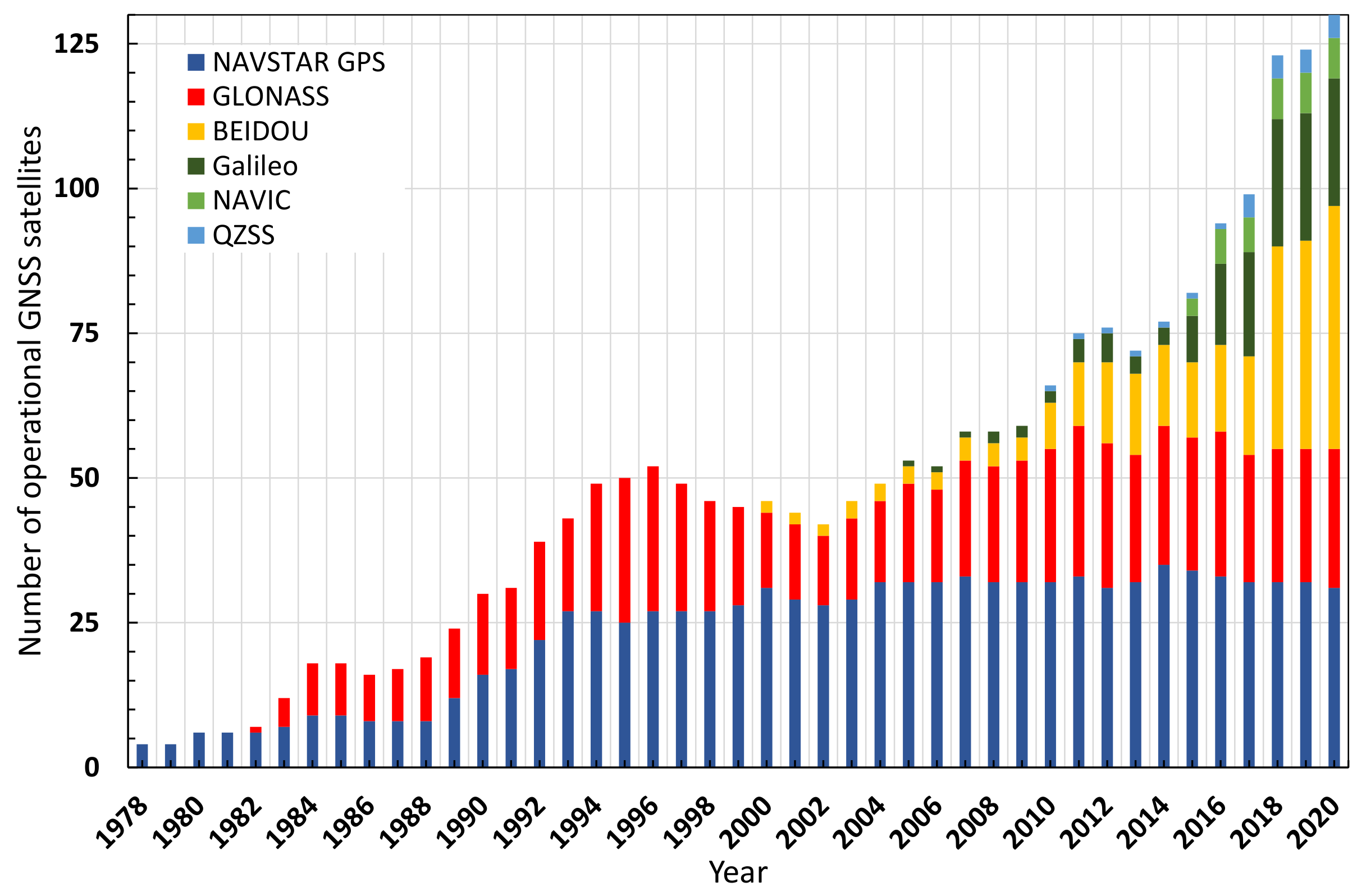
:1. Introduction
2. Materials and Methods
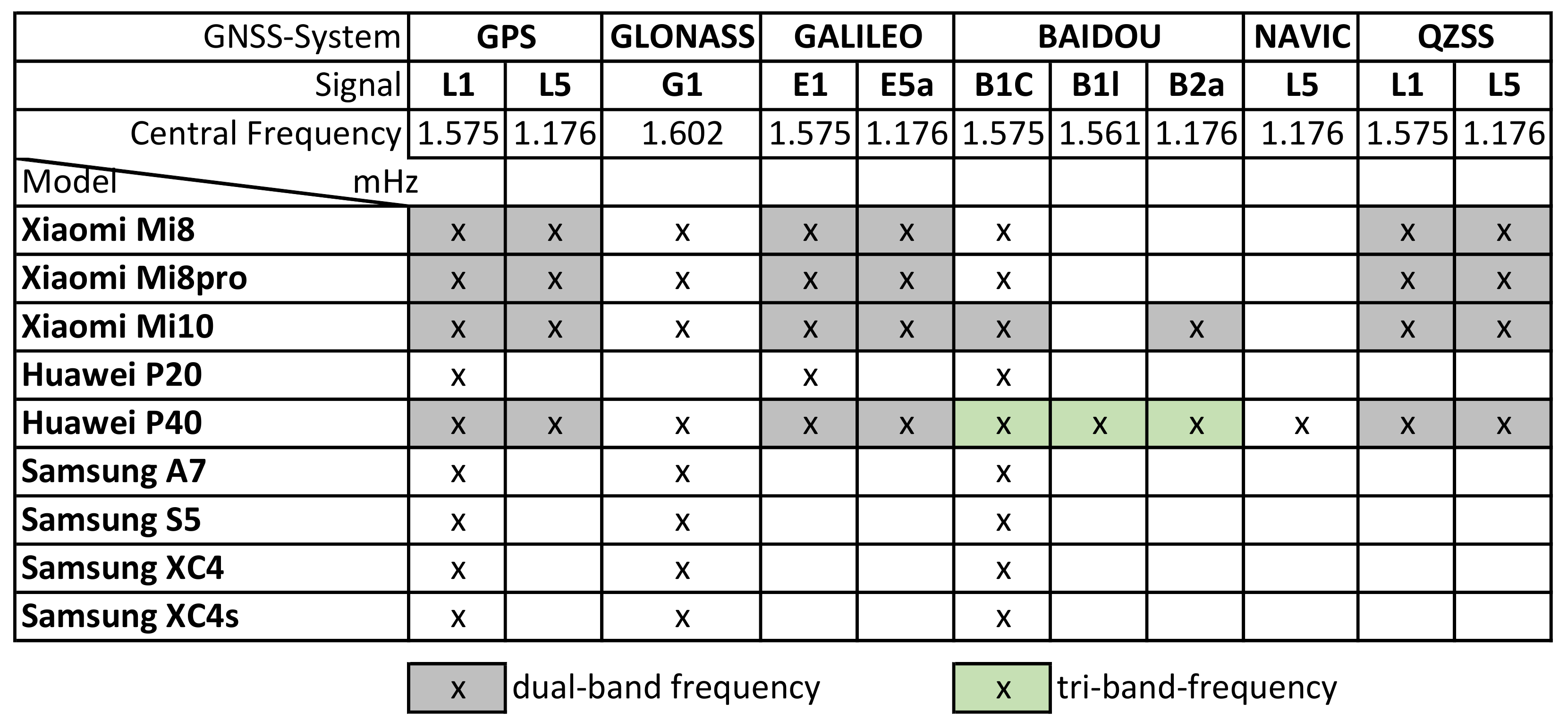
2.1. Study Design and Examined Smartphones
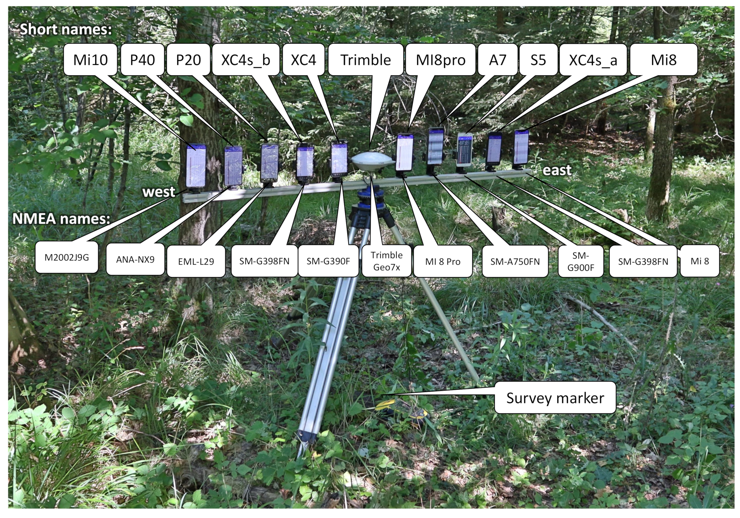
2.2. Experimental Setting
2.3. Data Capturing and Processing Software
- The data from the app ’GPStest’ were stored in the GNSSlog in a text file format on the smartphone. In addition to the header’s metadata, this also contains the navigation message data, raw GNSS measurements data, location fix data, and NMEA data.
- The data were subsequently read out asynchronously from the individual smartphones and stored in a file system.
- NMEA data were used to analyse the measured position and satellite data. The app used, ’GPStest’, stores all data in a joint log file containing NMEA data, metadata, navigation data, RAW data, and others. Using a parser, ’GNSS2NMEA’, programmed by the author in Python, the “correct” NMEA data were extracted from the GNSS log file, verified, and saved as a pure NMEA text file. This process was performed for each mobile phone and each recording separately with a batch process.
- The NMEA data were parsed and written into an MYSQL database. For this purpose, a Python program, ’NMEA2DB’, and database schema created by the author [16,21] were adapted and used to extract the relevant positioning and satellite data from the NMEA file. Some challenges were the different NMEA interpretations, the different NMEA 0183 versions (v2.3; v4.10; v4.11) of the smartphone manufacturers, and the NMEA standard’s different dialects. In particular, the handling of the standard with the different satellite systems and the multi-frequency data was very different. The parser was elaborately and explicitly adapted to the different smartphone models and their NMEA characteristics. The following NMEA 0183 datasets were analysed and the data were stored: (a) RMC: Recommended Minimum Sentence C; (b) GGA: Global Positioning System Fix Data; (c) GNS: GNSS fixed data; (d) GST: GNSS Pseudorange Error Statistics; (e) GSV: Satellites in view); and (f) GSA: GPS DOP and active satellites.The parsing process steps were as follows:
- (a)
- Automatic identification of the smartphone types/names. If the type/name was identical (i.e., Samsung XCOVER 4s a and b), this step was manually completed.
- (b)
- Extraction of all information from the relevant NMEA sentences.
- (c)
- Generation of SQL statements of the parsed data.
- (d)
- Execution of the SQL statements to transfer the satellite and position information into a MYSQL GNSS database [16].
- The position data and the satellite data were separately stored in two different tables (‘pos’ and ‘sat’) that are clearly linked in a one-to-many relationship using measurement-GUID, a receiver (e.g., smartphone), and a UTC timestamp. The tables were fully indexed and query-optimised.
2.4. Data Analysis
3. Results
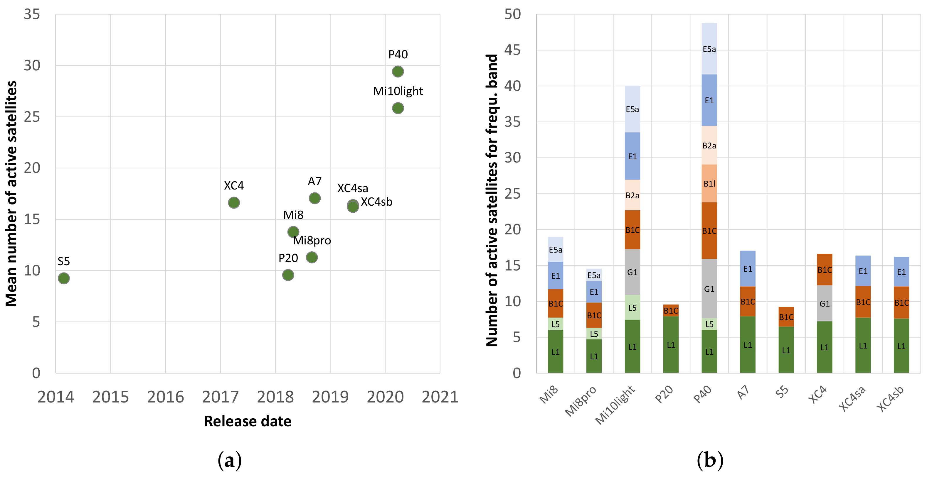
3.1. Different Signal Reception
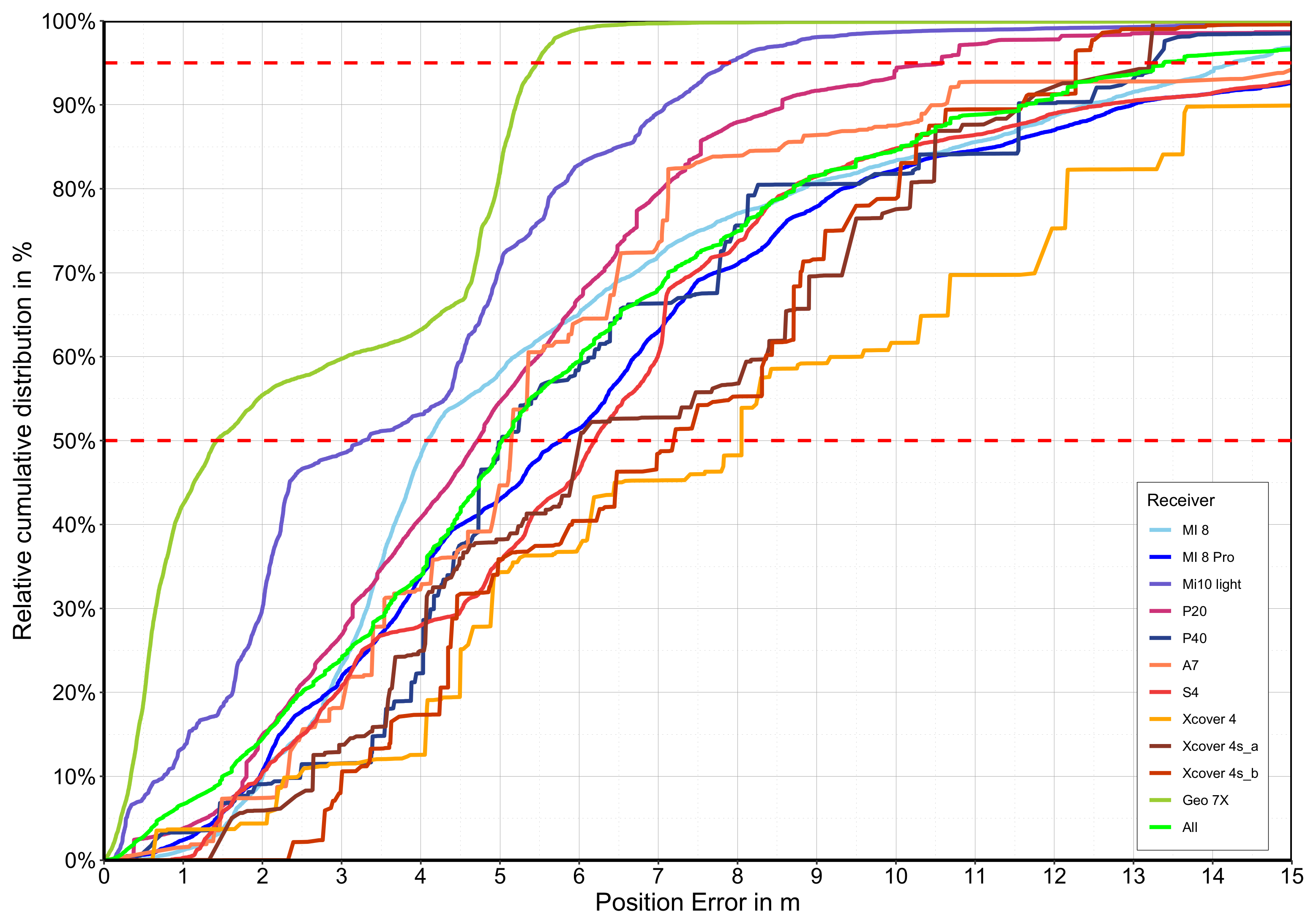
3.2. Static Accuracy
4. Discussion
5. Conclusions
Funding
Institutional Review Board Statement
Informed Consent Statement
Data Availability Statement
Conflicts of Interest
References
- GSM&GPS in the Same Package from Benefon—AfterDawn. Available online: https://www.afterdawn.com/news/article.cfm/1999/10/13/gsm_gps_in_the_same_package_from_benefon (accessed on 15 December 2019).
- Homepage Zum Neuen UMTS-Handy Siemens SXG75. Available online: http://www.sxg75.com/startseite/ (accessed on 5 April 2021).
- Going Mobile—Find a Galileo-Enabled Device to Use Today. Available online: https://www.usegalileo.eu/DE/inner.html#data=smartphone (accessed on 5 April 2021).
- The Smartphone Revolution. In GPS World. Available online: https://www.gpsworld.com/wirelesssmartphone-revolution-9183 (accessed on 15 December 2019).
- Number of Smartphones Sold to End Users Worldwide from 2007 to 2020. Available online: https://www.statista.com/statistics/263437/global-smartphone-sales-to-end-users-since-2007/ (accessed on 5 April 2021).
- Bettinger, P.; Merry, K.; Bayat, M.; Tomaštík, J. GNSS Use in Forestry—A multi-national survey from Iran, Slovakia and southern USA. Comput. Electron. Agric. 2019, 158, 369–383. [Google Scholar] [CrossRef]
- Hernández-Stefanoni, J.L.; Reyes-Palomeque, G.; Castillo-Santiago, M.A.; George-Chacon, S.P.; Huechacona-Ruiz, A.H.; Tun-Dzul, F.; Rondon-Rivera, D.; Dupuy, J.M. Effects of Sample Plot Size and GPS Location Errors on Aboveground Biomass Estimates from LiDAR in Tropical Dry Forests. Remote Sens. 2018, 10, 1586. [Google Scholar] [CrossRef] [Green Version]
- Feng, T.; Chen, S.; Feng, Z.; Shen, C.; Tian, Y. Effects of Canopy and Multi-Epoch Observations on Single-Point Positioning Errors of a GNSS in Coniferous and Broadleaved Forests. Remote Sens. 2021, 13, 2325. [Google Scholar] [CrossRef]
- Fauzi, M.; Idris, N.; Yahya, M.; Din, A.; Idris, N.; Lau, A.; Ishak, M. Tropical Forest Tree Positioning Accuracy: A Comparison of Low Cost GNSS-enabled devices. Int. J. Geoinform. 2016, 12, 59–66. [Google Scholar]
- Kitahara, F.; Mizoue, N.; Kajisa, T.; Murakami, T.; Yoshida, S. Positional Accuracy of National Forest Inventory Plots in Japan. J. For. Plan. 2010, 15, 73–79. [Google Scholar] [CrossRef]
- Lindroos, O.; Ringdahl, O.; LaHera, P.; Hohnloser, P.; Hellström, T. Estimating the Position of the Harvester Head—A Key Step towards the Precision Forestry of the Future? Croat. J. For. Eng. 2015, 36, 147–164. [Google Scholar]
- Olivera, A.; Visser, R. Development of forest-yield maps generated from Global Navigation Satellite System (GNSS)-enabled harvester StanForD files: Preliminary concepts. N. Z. J. For. Sci. 2016, 46. [Google Scholar] [CrossRef] [Green Version]
- Zimbelman, E.G.; Keefe, R.F. Real-time positioning in logging: Effects of forest stand characteristics, topography, and line-of-sight obstructions on GNSS-RF transponder accuracy and radio signal propagation. PLoS ONE 2018, 13, e0191017. [Google Scholar] [CrossRef]
- Purfürst, F.; Erler, J.; Grüger, H.; Heberer, A.; Schmidt, A.; Wehner, T. Hochgenaue Positionsbestimmung von Forstmaschinen. Forst Tech. 2007, 19, 12–16. (In German) [Google Scholar]
- Purfürst, F.T.; Schreiber, J.; Böhme, I.; Erler, J. Befahrungsdokumentation eines Harvesters—Ein praktischer Genauigkeitsversuch (Driving documentation of a harvester—A practical accuracy test). AFZ Der Wald 2011, 66, 22–26. (In German) [Google Scholar]
- Purfürst, T. Befahrung von Waldböden: Ursache, Wirkung, Lokalisation, Digitale Dokumentation und Datenmanagement (Driving on Forest Soils: Cause, Effect, Localisation, Digital Documentation and Data Management). Habilitation Thesis, Technische Universität Dresden, Dresden, Germany, 2019; 434p. (In German). [Google Scholar]
- Kaartinen, H.; Hyyppä, J.; Vastaranta, M.; Kukko, A.; Jaakkola, A.; Yu, X.; Pyörälä, J.; Liang, X.; Liu, J.; Wang, Y.; et al. Accuracy of Kinematic Positioning Using Global Satellite Navigation Systems under Forest Canopies. Forests 2015, 6, 3218–3236. [Google Scholar] [CrossRef]
- Frost, M.; Hölldorfer, B.; Müller, M.; Purfürst, T. Digitale Infrastruktur mit NavLog bei den BaySF (Digital infrastructure with NavLog at Bavarian State Forest Enterprise). AFZ Der Wald 2015, 70, 13–15. (In German) [Google Scholar]
- Athanassiadis, D.; Bergström, D.; Hellström, T.; Lindroos, O.; Nordfjell, T.; Ringdahl, O. Path Tracking for Autonomous Forwarders in Forest Terrain; Stellenbosch University: Stellenbosch, South Africa, 2010; ISBN 978-0-7972-1324-1. [Google Scholar]
- Müller, F.; Jaeger, D.; Hanewinkel, M. Digitization in wood supply—A review on how Industry 4.0 will change the forest value chain. Comput. Electron. Agric. 2019, 162, 206–218. [Google Scholar] [CrossRef]
- Purfürst, T. GNSS im Wald: Grundlagenuntersuchungen (GNSS under Forest Canopy: Basic Research), 1st ed.; AV Akademikerverlag: Saarbrücken, Germany, 2013; 224p, (In German). ISBN 3639471156. [Google Scholar]
- Fei, Y.; Xueqi, H.; Lidan, X.; Yongrui, W. Construction and Accuracy Analysis of a BDS/GPS-Integrated Positioning Algorithm for Forests. Croat. J. For. Eng. 2021, 42. [Google Scholar] [CrossRef]
- Blum, R.; Bischof, R.; Sauter, U.; Foeller, J. Tests of reception of the combination of GPS and GLONASS signals under and above forest canopy in the Black Forest, Germany, using choke ring antennas. Int. J. For. Eng. 2016, 27, 2–14. [Google Scholar] [CrossRef]
- Hasegawa, H.; Yoshimura, T. Estimation of GPS positional accuracy under different forest conditions using signal interruption probability. J. For. Res. 2007, 12, 32–36. [Google Scholar] [CrossRef]
- Hasegawa, H.; Yoshimura, T. Application of dual-frequency GPS receivers for static surveying under tree canopies. J. For. Res. 2003, 8, 103–110. [Google Scholar] [CrossRef]
- Weaver, S.A.; Ucar, Z.; Bettinger, P.; Merry, K. How a GNSS Receiver Is Held May Affect Static Horizontal Position Accuracy. PLoS ONE 2015, 10, e0124696. [Google Scholar] [CrossRef] [Green Version]
- Ransom, M.; Rhynold, J.; Bettinger, P. Performance of Mapping-Grade GPS Receivers in Southeastern Forest Conditions. Rev. Undergrad. Res. Agric. Life Sci. 2010, 5, 2. [Google Scholar]
- Ordóñez Galán, C.; Rodríguez Pérez, J.; García Cortés, S.; Bernardo Sánchez, A. Analysis of the influence of forestry environments on the accuracy of GPS measurements by means of recurrent neural networks. Math. Comput. Model. 2013, 57, 2016–2023. [Google Scholar] [CrossRef]
- Iordache, E.; Mihalila, M. Evaluation of GPS performance in Romanian Mountain Forests. RevCAD J. Geod. Cadastre 2010, 10, 194–200. [Google Scholar]
- Rodriguez-Perez, J.; Alvarez, M.; Sanz, E.; Gavela, A. Comparison of GPS Receiver Accuracy and Precision in Forest Environments. In Practical Recomondations Regarding Methods and Receiver Selection. In Proceedings of the GNSS Processing and Applications, XXIII FIG Congress, Munich, Germany, 10 October 2006. [Google Scholar]
- Rodriiguez-Perez, J.R.; Alvarez, M.F.; Sanz-Ablanedo, E. Assessment of Low-Cost GPS Receiver Accuracy and Precision in Forest Environments. J. Surv. Eng. 2007, 133, 159–167. [Google Scholar] [CrossRef] [Green Version]
- Danskin, S.; Bettinger, P.; Jordan, T.; Cieszewski, C. A comparision of GPS performance in a sourthern hardwood forest: Exploring low-cost solutions for forestry applications. South. J. Appl. For. 2009, 33, 9–16. [Google Scholar] [CrossRef] [Green Version]
- Sawaguchi, I.; Seitoh, Y.; Tatsukawa, S. A study of the effects of stems and canopies on the signal to noise ration of GPS signals. J. For. Res. 2005, 10, 395–401. [Google Scholar] [CrossRef]
- Sawaguchi, i.; Nemoto, Y.; Tatsukawa, S. Effects of moisture in wood materials on the SNR of GPS signals. J. For. Res. 2009, 14, 63–72. [Google Scholar] [CrossRef]
- Ramm, K.; Schieger, V. Low-Cost GPS-Empfänger für Anwendungen im Forstbereich. Baufachinformationen 2004, 66, 178–184. [Google Scholar]
- Bettinger, P.; Fei, S. One Year’s Experience with a Recreation-Grade GPS Receiver. MCFNS 2010, 2, 153–160. [Google Scholar]
- Koh, S.; Sarabandi, K. Polarimetric Channel Characterization of Foliage for Performance Assessment of GPS Receivers Under Tree Canopies. IEEE Trans. Antennas Propag. 2002, 50, 713–726. [Google Scholar]
- Uzodinma, V.N.; Nwafor, U. Degradation of GNSS Accuracy by Multipath and Tree Canopy Distortions in a School Environment: A Recent Study. Chall. Issues Environ. Earth Sci. 2021, 4, 68–77. [Google Scholar] [CrossRef]
- Falkenried, L. Positionierung im Wald mithilfe von Satelliten (Positioning in the forest with the help of satellites). AFZ-Der Wald 2004, 23, 1240–1241. (In German) [Google Scholar]
- Sigrist, P.; Coppin, P.; Hermy, M. Impact of forest canopy on quality and accuracy of GPS measurements. Int. J. Remote Sens. 1999, 20, 3595–3610. [Google Scholar] [CrossRef]
- Bastos, A.S.; Hasegawa, H. Behavior of GPS Signal Interruption Probability under Tree Canopies in Different Forest Conditions. Eur. J. Remote Sens. 2013, 46, 613–622. [Google Scholar] [CrossRef]
- Danskin, S.; Bettinger, P.; Jordan, T. Multipath Mitigation under Forest Canopies: A Choke Ring Antenna Solution. For. Sci. 2009, 55, 109–116. [Google Scholar] [CrossRef]
- Gogoi, N.; Minetto, A.; Linty, N.; Dovis, F. A Controlled-Environment Quality Assessment of Android GNSS Raw Measurements. Electronics 2019, 8, 5. [Google Scholar] [CrossRef] [Green Version]
- Robustelli, U.; Baiocchi, V.; Pugliano, G. Assessment of Dual Frequency GNSS Observations from a Xiaomi Mi 8 Android Smartphone and Positioning Performance Analysis. Electronics 2019, 8, 91. [Google Scholar] [CrossRef] [Green Version]
- Brach, M.; Stereńczak, K.; Bolibok, L.; Łukasz, K.; Krok, G.; Laszkowski, M. Impacts of forest spatial structure on variation of the multipath phenomenon of navigation satellite signals. Folia For. Pol. 2019, 61, 3–21. [Google Scholar] [CrossRef] [Green Version]
- Akbulut, R.; Ucar, Z.; Bettinger, P.; Merry, K.; Obata, S. Effects of forest thinning on static horizontal positions collected with a mapping-grade GNSS receiver. Math. Comput. For. Nat. Resour. Sci. MCFNS 2017, 9, 14–21. [Google Scholar]
- Bi, J.; Zhen, J.; Guo, Y. Positioning accuracy analysis of GPS and A-GPS for Android mobile phone. Bull. Surv. Mapp. 2016, 7, 10–13. [Google Scholar]
- Li, G.; Geng, J. Characteristics of raw multi-GNSS measurement error from Google Android smart devices. GPS Solut. 2019, 24, 90. [Google Scholar] [CrossRef]
- Zangenehnejad, F.; Gao, Y. GNSS smartphones positioning: Advances, challenges, opportunities, and future perspectives. Satell. Navig. 2021, 2, 24. [Google Scholar] [CrossRef]
- Brach, M. Rapid Static Positioning Using a Four System GNSS Receivers in the Forest Environment. Forests 2022, 13, 45. [Google Scholar] [CrossRef]
- Wu, Q.; Sun, M.; Zhou, C.; Zhang, P. Precise Point Positioning Using Dual-Frequency GNSS Observations on Smartphone. Sensors 2019, 19, 2189. [Google Scholar] [CrossRef] [PubMed] [Green Version]
- Dabove, P.; Di Pietra, V. Single-Baseline RTK Positioning Using Dual-Frequency GNSS Receivers Inside Smartphones. Sensors 2019, 19, 4302. [Google Scholar] [CrossRef] [PubMed] [Green Version]
- Elmezayen, A.; El-Rabbany, A. Precise Point Positioning Using World’s First Dual-Frequency GPS/GALILEO Smartphone. Sensors 2019, 19, 2593. [Google Scholar] [CrossRef] [Green Version]
- Pesyna, K.M.; Heath, R.W.; Humphreys, T.E. Centimeter Positioning with a Smartphone-Quality GNSS Antenna. In Proceedings of the ION GNSS Conference, Tampa, FL, USA, 8–12 September 2014. [Google Scholar]
- Paziewski, J.; Fortunato, M.; Mazzoni, A.; Odolinski, R. An analysis of multi-GNSS observations tracked by recent Android smartphones and smartphone-only relative positioning results. Measurement 2021, 175, 109162. [Google Scholar] [CrossRef]
- Yong, C.Z.; Odolinski, R.; Zaminpardaz, S.; Moore, M.; Rubinov, E.; Er, J.; Denham, M. Instantaneous, Dual-Frequency, Multi-GNSS Precise RTK Positioning Using Google Pixel 4 and Samsung Galaxy S20 Smartphones for Zero and Short Baselines. Sensors 2021, 21, 8318. [Google Scholar] [CrossRef]
- Uradziński, M.; Bakuła, M. Assessment of Static Positioning Accuracy Using Low-Cost Smartphone GPS Devices for Geodetic Survey Points’ Determination and Monitoring. Appl. Sci. 2020, 10, 5308. [Google Scholar] [CrossRef]
- Hesselbarth, A.; Wanninger, L. GNSS-Messungen mit Smartphones–Analyse der Beobachtungsdaten und cm-Genaue Positionsbestimmung (GNSS Measurements with Smartphones—Observation Analysis and cm-accurate Positioning). ZFV Z. Geodasie Geoinf. Landmanag. 2021, 3, 189–197. (In German) [Google Scholar] [CrossRef]
- Wanninger, L.; Hesselbarth, A. GNSS code and carrier phase observations of a Huawei P30 smartphone: Quality assessment and centimeter-accurate positioning. GPS Solut. 2020, 24, 64. [Google Scholar] [CrossRef] [Green Version]
- Heßelbarth, A. Statische und Kinematische GNSS-Auswertung Mittels Precise Point Positioning (PPP) (Static and Kinematic GNSS Evaluation Using Precise Point Positioning (PPP)). Ph.D. Thesis, University of Technology Dresden, Dresden, Germany, 2011. (In German). [Google Scholar]
- Valbuena, R.; Moauro, F.; Rodriguez-Perez, J.; Manzanera, J.A. Accuracy and precision of GPS receivers under forest canopies in a mountainous environment. Span. J. Agric. Res. 2010, 8, 1047–1057. [Google Scholar] [CrossRef]
- Indian Regional Navigation Satellite System. Available online: https://en.wikipedia.org/w/index.php?title=Indian_Regional_Navigation_Satellite_System&oldid=966705987 (accessed on 14 January 2021).
- Quasi-Zenith Satellite System. Available online: https://en.wikipedia.org/w/index.php?title=Quasi-Zenith_Satellite_System&oldid=957326726 (accessed on 14 January 2021).
- List of GLONASS Satellites. Available online: https://en.wikipedia.org/w/index.php?title=List_of_GLONASS_satellites&oldid=967043328 (accessed on 14 January 2021).
- List of GPS Satellites. Available online: https://en.wikipedia.org/w/index.php?title=List_of_GPS_satellites&oldid=967531019 (accessed on 14 January 2021).
- List of BeiDou Satellites. Available online: https://en.wikipedia.org/w/index.php?title=List_of_BeiDou_satellites&oldid=967572056 (accessed on 14 January 2021).
- Beidou. Beidou Satellite Navigation System. Available online: http://www.beidou.gov.cn/ (accessed on 14 January 2021).
- Constellation Information|European GNSS Service Centre. Available online: https://www.gsc-europa.eu/system-service-status/constellation-information (accessed on 14 January 2021).
- GLONASS Onstellation Status. Available online: https://www.glonass-iac.ru/en/GLONASS/index.php (accessed on 14 January 2021).
- Tomaštík, J.; Varga, M. Practical applicability of processing static, short-observation-time raw GNSS measurements provided by a smartphone under tree vegetation. Measurement 2021, 178, 109397. [Google Scholar] [CrossRef]
- Tomaštík, J.; Chudá, J.; Tunák, D.; Chudý, F.; Kardoš, M. Advances in smartphone positioning in forests: Dual-frequency receivers and raw GNSS data. Forestry 2020, 94, 292–310. [Google Scholar] [CrossRef]
- BCM47755—Third-Generation GNSS Location Hub with Dual Frequency Support. Available online: https://www.broadcom.com/products/wireless/gnss-gps-socs/bcm47755 (accessed on 22 December 2019).
- XiaomiMI8. Available online: https://www.gsmarena.com/xiaomi_mi_8-9065.php (accessed on 22 December 2019).
- Guo, L.; Wang, F.; Sang, J.; Lin, X.; Gong, X.; Zhang, W. Characteristics Analysis of Raw Multi-GNSS Measurement from Xiaomi Mi 8 and Positioning Performance Improvement with L5/E5 Frequency in an Urban Environment. Remote Sens. 2020, 12, 744. [Google Scholar] [CrossRef] [Green Version]
- Fortunato, M.; Ravanelli, M.; Mazzoni, A. Real-Time Geophysical Applications with Android GNSS Raw Measurements. Remote Sens. 2019, 11, 2113. [Google Scholar] [CrossRef] [Green Version]
- Chen, B.; Gao, C.; Liu, Y.; Sun, P. Real-time Precise Point Positioning with a Xiaomi MI 8 Android Smartphone. Sensors 2019, 19, 2835. [Google Scholar] [CrossRef] [Green Version]
- Massarweh, L.; Darugna, F.; Psychas, D.; Bruno, J. Statistical Investigation of Android GNSS Data: Case Study Using Xiaomi Mi 8 Dual-Frequency Raw Measurements. In Proceedings of the 32nd International Technical Meeting of the Satellite Division of The Institute of Navigation (ION GNSS+ 2019), Miami, FL, USA, 16–20 September 2019; pp. 3847–3861. [Google Scholar] [CrossRef]
- Magalhães, A.; Bastos, L.; Maia, D.; Gonçalves, J.A. Relative Positioning in Remote Areas Using a GNSS Dual Frequency Smartphone. Sensors 2021, 21, 8354. [Google Scholar] [CrossRef]
- Massarweh, L.; Fortunato, M.; Gioia, C. Assessment of Real-time Multipath Detection with Android Raw GNSS Measurements by Using a Xiaomi Mi 8 Smartphone. In Proceedings of the 2020 IEEE/ION Position, Location and Navigation Symposium (PLANS), Portland, OR, USA, 20–23 April 2020; pp. 1111–1122. [Google Scholar] [CrossRef]
- BCM47765—Second Generation Dual-Frequency GNSS Chip. Available online: https://www.broadcom.com/products/wireless/gnss-gps-socs/bcm47765 (accessed on 5 April 2021).
- Broadcom’s Second-Generation Dual-Frequency GNSS Uses New L5 Signals. Available online: https://www.gpsworld.com/broadcoms-second-generation-dual-frequency-gnss-uses-l5-signals/ (accessed on 2 February 2021).
- Shinghal, G. Analysis and Conditioning of Gnss Measurements from Smartphones for Precise Point Positioning in Realistic Environments. Master’s Thesis, York University Toronto, Toronto, ON, USA, 2020. [Google Scholar]
- epey Mobile Phone. Available online: https://www.epey.co.uk/phone (accessed on 27 December 2021).
- Using GNSS Raw Measurements on Android Devices—Towards Better Location Performance in Mass Market Applications (White Paper); Publications Office of the European Union: Luxembourg. 2018. Available online: https://www.gsa.europa.eu/system/files/reports/gnss_raw_measurement_web_0.pdf (accessed on 19 January 2022).
- Gpstest. Available online: https://github.com/barbeau/gpstest (accessed on 27 December 2020).
- Holm, S. A Simple Sequentially Rejective Multiple Test Procedure. Scand. J. Stat. 1979, 6, 65–70. [Google Scholar]
- Robustelli, U.; Paziewski, J.; Pugliano, G. Observation Quality Assessment and Performance of GNSS Standalone Positioning with Code Pseudoranges of Dual-Frequency Android Smartphones. Sensors 2021, 21, 2125. [Google Scholar] [CrossRef]
- Heßelbarth, A.; Wanninger, L. Towards centimeter accurate positioning with smartphones. In Proceedings of the 2020 European Navigation Conference (ENC), Dresden, Germany, 23–24 November 2020; pp. 1–8. [Google Scholar] [CrossRef]
- Tomaštík, J.; Saloň, Š.; Piroh, R. Horizontal accuracy and applicability of smartphone GNSS positioning in forests. For. Int. J. For. Res. 2016, 90, 187–198. [Google Scholar] [CrossRef] [Green Version]
- Braasch, M. Überprüfung der Lagegenauigkeit und der Empfangsbedingungen für Echtzeitkorrigierte GPS Messungen unter Benutzung der BEACON Signale. Master’s Thesis, Hochschule für Forstwirtschaft Rottenburg, Rottenburg am Neckar, Germany, 2006. [Google Scholar]
- Engels, F. Anforderungen an ein GPS-Gerät beim Einsatz im forstlichen Versuchswesen (Requirements for a GPS Device When Used in Forestry Experiments). AFZ-Der Wald 2001, 56, 513–516. (In German) [Google Scholar]
- Næsset, E.; Gjevestad, J. Performance of GPS Precise Point Positioning Under Conifer Forest Canopies. Photogramm. Eng. Remote Sens. 2008, 74, 661–668. [Google Scholar] [CrossRef]
- Holley, B.; Yawn, M. Accuracies of Various GPS Antennas under Forested Conditions. In Proceedings of the 5th Southern Forestry and Natural Resources GIS Conference, Asheville, NC, USA, 12–14 June 2006; Warnell School of Forestry and Natural Resources, University of Georgia: Athens, GA, USA, 2006. [Google Scholar]
- Anderson, H.; Clarkin, T.; Witerberger, K.; Strunk, J. An accuracy assessment of positions obtained using survey-grade global positioning system receivers across a range of forest conditions within the Tanana Valley of Interior Alaska. West. J. Appl. For. 2009, 24, 128–133. [Google Scholar] [CrossRef] [Green Version]
- Yoshimura, T.; Hasegawa, H. Comparing the precision and accuracy of GPS positioning in forested areas. J. For. Res. 2003, 8, 147–152. [Google Scholar] [CrossRef]
- Schwalbe, E.; Maas, H.G.; Roscher, M.; Wagner, S. Profile based sub-pixel-classification of hemispherical images for solar radiation analysis in forest ecosystems. Int. Arch. Photogram. Remote Sens. Spat. Inf. Sci. 2006, 36, P7. [Google Scholar]
- Szot, T.; Specht, C.; Specht, M.; Dabrowski, P.S. Comparative analysis of positioning accuracy of Samsung Galaxy smartphones in stationary measurements. PLoS ONE 2019, 14, e0215562. [Google Scholar] [CrossRef]
- Francesco, D.; Wübbena, J.; Akira, I.; Wübbena, T.; Wübbena, G. RTK and PPP-RTK using smartphones: From short-baseline to long-baseline applications. In Proceedings of the 32nd international technical meeting of the satellite division of the Institute of Navigation. ION GNSS, Miami, FL, USA, 16–20 September 2019; pp. 3932–3945. [Google Scholar]


| ID | Manufact. | Type | Model | NF | RY/HY/P/API |
|---|---|---|---|---|---|
| Mi8 | Xiaomi | Mi 8 | Mi 8 | 2 | 2018/2018/10/29 |
| Mi8pro | Xiaomi | Mi 8 Pro | MI 8 Pro | 2 | 2018/2018/10/29 |
| Mi10 | Xiaomi | Mi 10 light | M2002J9G | 2 | 2020/2019/10/29 |
| P20 | Huawei | P20 | EML-L29 | 1 | 2018/2016/10/29 |
| P40 | Huawei | P40 | ANA-NX9 | 3 | 2020/2018/10/29 |
| S5 | Samsung | S5 | SM-G900F | 1 | 2014/2013/6/23 |
| A7 | Samsung | A7 | SM-A750FN | 1 | 2018/2016/10/29 |
| XC4 | Samsung | Xcover 4 | SM-G390F | 1 | 2017/2015/9/28 |
| XC4s_a | Samsung | Xcover 4s | SM-G398FN | 1 | 2019/2016/10/29 |
| XC4s_b | Samsung | Xcover 4s | SM-G398FN | 1 | 2019/2016/10/29 |
| Trimble | Trimble | Geo7x | TrimbleGeo7x | 2 |
| ID | Latitute | Longtitute | SP ID | FS | Conditions and Main Obstacle for Reception |
|---|---|---|---|---|---|
| 1 | 48.0651990 | 11.5655060 | 7935 0188 | B | Beech dominated mixed forest, 13 m to forest road, closed dense canopy, trees > 15 m |
| 2 | 48.0502484 | 11.4392006 | 7934 0040 | B | Beech dominated mixed forest, 6 m to forest road, closed canopy with crown gaps towards the road, trees > 12 m |
| 3 | 48.0499501 | 11.4425390 | 7934 0041 | B | Beech dominated mixed forest, 10 m to forest road, closed canopy, trees > 15 m |
| 4 | 47.9962202 | 7.7610121 | 8012 031 | BW | Beech dominated deciduous forest, closed canopy, trees > 20 m |
| 5 | 48.0378690 | 7.9720488 | 7913 163 00 | BW | Fir dominated mixed forest, northeast slope, closed canopy, trees > 30 m |
| 6 | 48.0269512 | 7.9535119 | 7913 134 00 | BW | Beech dominated mixed forest, closed canopy, trees > 25 m |
| 7 | 47.8880590 | 8.1546365 | 8114 034 | BW | Spruce, pure stand, medium dense canopy, trees > 25 m, natural rejuvenation > 4 m |
| 8 | 47.8885525 | 8.1558580 | 8114 034 01 | BW | Spruce, windthrow area with large open sky areas, trees > 25 m |
| 9 | 47.8907364 | 8.1619936 | 8114 269 | BW | Spruce, pure stand, 6 m to forest road, closed canopy with crown gaps towards the road, trees > 25 m |
| 10 | 47.9650230 | 7.8463260 | 8013 025 | BW | Beech dominated mixed forest, northward slope, closed canopy, trees > 25 m |
| 11 | 50.6989621 | 13.1634072 | 5244000100 | S | Spruce, pure stand, hilltop, canopy with greater gaps, trees > 20 |
| 12 | 50.6971547 | 13.1657759 | 5244000101 | S | Spruce, pure stand, 2 m to forest road, closed, very dense canopy, crown gaps towards the road, trees > 12 m |
| 13 | 50.7170483 | 13.1437748 | 5244002201 | S | Beech dominated mixed forest, closed canopy with small gaps, trees > 20 m |
| 14 | 50.6900370 | 13.1400410 | 5344006100 | S | Spruce, pure stand, 4 m to forest road, closed canopy, crown gaps towards the road, trees > 25 m, |
| 15 | 50.7026740 | 13.1225790 | 5244001201 | S | Spruce, pure stand, 5 m to forest road, closed canopy with crown gaps towards the road, trees > 25 m |
| Smartphone | GPS | GLONASS | BAIDOU | GALILEO | Sum | |||||
|---|---|---|---|---|---|---|---|---|---|---|
| L1 | L5 | G1 | B1C | B1l | B2a | E1 | E5a | Sat’s | FBands | |
| Xiaomi MI 8 | 6.0 | 1.8 | 4.0 | 3.8 | 3.5 | 13.8 | 19.0 | |||
| Xiaomi MI 8 Pro | 4.7 | 1.6 | 3.5 | 3.0 | 1.7 | 11.3 | 14.6 | |||
| Xiaomi Mi10 light | 7.5 | 3.4 | 6.4 | 5.4 | 4.3 | 6.6 | 6.5 | 25.8 | 40.0 | |
| Huawei P20 | 7.9 | 1.6 | 9.6 | 9.6 | ||||||
| Huawei P40 | 6.1 | 1.6 | 8.3 | 7.9 | 5.3 | 5.4 | 7.2 | 7.1 | 29.4 | 48.8 |
| Samsung A7 | 7.9 | 4.2 | 5.0 | 17.1 | 17.1 | |||||
| Samsung S5 | 6.5 | 2.8 | 9.2 | 9.2 | ||||||
| Samsung Xcover 4 | 7.2 | 5.0 | 4.4 | 16.6 | 16.6 | |||||
| Samsung Xcover 4s A | 7.7 | 4.4 | 4.3 | 16.4 | 16.4 | |||||
| Samsung Xcover 4s B | 7.6 | 4.5 | 4.1 | 16.2 | 16.2 | |||||
| Receivers | MF | SD | CEP | CEP | CEP | CEP | CEP | DRMS | 2DRMS | n | |
|---|---|---|---|---|---|---|---|---|---|---|---|
| (m) | (m) | (m) | (m) | (m) | (m) | (m) | (m) | (m) | |||
| Geo 7X | Yes | 2.49 | 2.11 | 0.57 | 1.42 | 4.76 | 5.46 | 6.97 | 3.26 | 6.52 | 12,096 |
| P20 | No | 5.22 | 4.54 | 2.82 | 4.72 | 6.67 | 10.58 | 37.64 | 6.92 | 13.83 | 12,270 |
| P40 | Yes | 6.28 | 3.58 | 4.03 | 5.03 | 7.97 | 13.38 | 16.00 | 7.22 | 14.45 | 12,645 |
| MI 8 | Yes | 5.85 | 4.19 | 3.11 | 4.08 | 7.52 | 14.27 | 22.53 | 7.20 | 14.39 | 9492 |
| MI 8 Pro | Yes | 6.75 | 5.26 | 3.34 | 5.77 | 8.51 | 16.34 | 30.46 | 8.55 | 17.10 | 11,780 |
| Mi10 light | Yes | 3.73 | 2.62 | 1.79 | 3.28 | 5.39 | 7.89 | 16.10 | 4.56 | 9.13 | 12,627 |
| Xcover 4 | No | 10.44 | 10.19 | 4.50 | 8.05 | 11.97 | 41.99 | 47.25 | 14.59 | 29.17 | 12,333 |
| Xcover 4s_a | No | 6.90 | 3.48 | 4.06 | 6.02 | 9.49 | 13.25 | 13.25 | 7.73 | 15.46 | 12,224 |
| Xcover 4s_b | No | 7.20 | 3.44 | 4.34 | 7.22 | 9.22 | 12.27 | 19.72 | 7.98 | 15.96 | 12,254 |
| A7 | No | 5.86 | 3.70 | 3.40 | 5.17 | 7.06 | 15.80 | 17.74 | 6.94 | 13.87 | 11,691 |
| S5 | No | 6.73 | 4.41 | 3.26 | 6.20 | 8.14 | 16.72 | 22.55 | 8.05 | 16.09 | 11,926 |
| MultiF No | No | 7.07 | 5.77 | 3.75 | 6.02 | 8.79 | 13.64 | 41.99 | 9.13 | 18.25 | 72,698 |
| MultiF Yes | Yes | 5.62 | 4.16 | 2.79 | 4.73 | 7.32 | 13.38 | 24.04 | 6.99 | 13.98 | 46,544 |
| All | 6.14 | 5.17 | 3.08 | 5.03 | 8.03 | 13.38 | 41.99 | 8.03 | 16.05 | 131,338 |
| Geo 7X | Mi 8 | MI 8P | MI 10 | P20 | P40 | A7 | S5 | XC4sa | XC4sb | |
|---|---|---|---|---|---|---|---|---|---|---|
| Xiaomi Mi 8 | 0.00 | |||||||||
| Xiaomi Mi 8 Pro | 0.00 | 0.00 | ||||||||
| Xiaomi Mi 10 light | 0.00 | 0.00 | 0.00 | |||||||
| Huawei P20 | 0.00 | 0.00 | 0.00 | 0.00 | ||||||
| Huawei P40 | 0.00 | 0.00 | 0.88 | 0.00 | 0.00 | |||||
| Samsung A7 | 0.00 | 0.00 | 0.00 | 0.00 | 0.00 | 0.00 | ||||
| Samsung S5 | 0.00 | 0.00 | 0.00 | 0.00 | 0.00 | 0.00 | 0.00 | |||
| Samsung Xcover 4s_a | 0.00 | 0.00 | 0.00 | 0.00 | 0.00 | 0.00 | 0.00 | 0.00 | ||
| Samsung Xcover 4s_b | 0.00 | 0.00 | 0.00 | 0.00 | 0.00 | 0.00 | 0.00 | 0.00 | 0.00 | |
| Samsung Xcover 4 | 0.00 | 0.00 | 0.00 | 0.00 | 0.00 | 0.00 | 0.00 | 0.00 | 0.00 | 0.00 |
Publisher’s Note: MDPI stays neutral with regard to jurisdictional claims in published maps and institutional affiliations. |
© 2022 by the author. Licensee MDPI, Basel, Switzerland. This article is an open access article distributed under the terms and conditions of the Creative Commons Attribution (CC BY) license (https://creativecommons.org/licenses/by/4.0/).
Share and Cite
Purfürst, T. Evaluation of Static Autonomous GNSS Positioning Accuracy Using Single-, Dual-, and Tri-Frequency Smartphones in Forest Canopy Environments. Sensors 2022, 22, 1289. https://doi.org/10.3390/s22031289
Purfürst T. Evaluation of Static Autonomous GNSS Positioning Accuracy Using Single-, Dual-, and Tri-Frequency Smartphones in Forest Canopy Environments. Sensors. 2022; 22(3):1289. https://doi.org/10.3390/s22031289
Chicago/Turabian StylePurfürst, Thomas. 2022. "Evaluation of Static Autonomous GNSS Positioning Accuracy Using Single-, Dual-, and Tri-Frequency Smartphones in Forest Canopy Environments" Sensors 22, no. 3: 1289. https://doi.org/10.3390/s22031289
APA StylePurfürst, T. (2022). Evaluation of Static Autonomous GNSS Positioning Accuracy Using Single-, Dual-, and Tri-Frequency Smartphones in Forest Canopy Environments. Sensors, 22(3), 1289. https://doi.org/10.3390/s22031289