AgriLogger: A New Wireless Sensor for Monitoring Agrometeorological Data in Areas Lacking Communication Networks †
Abstract
1. Introduction
2. Material and Methods
2.1. AgriLogger Structure
2.2. AgriLogger Composition
2.3. Unmanned Aerial System: Drone
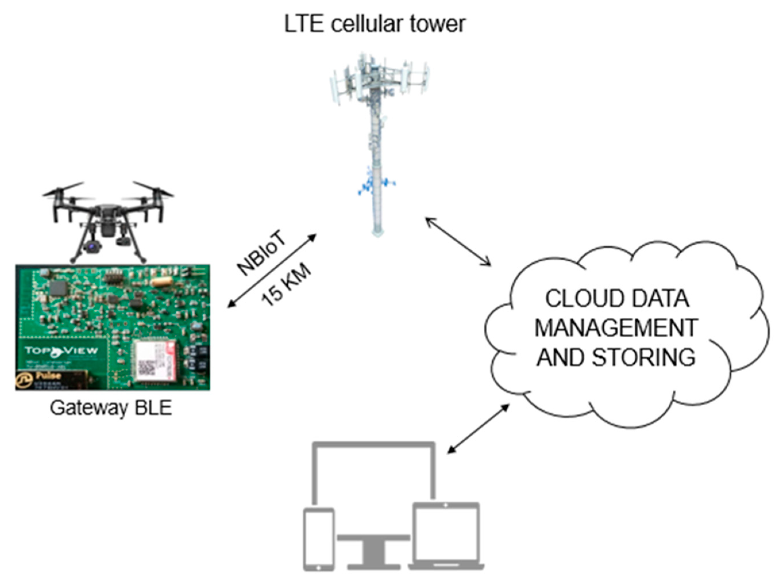
2.4. Gateway BLE
2.5. Field Test of AgriLogger on a Vineyard
3. Results and Discussion
3.1. Battery Endurance
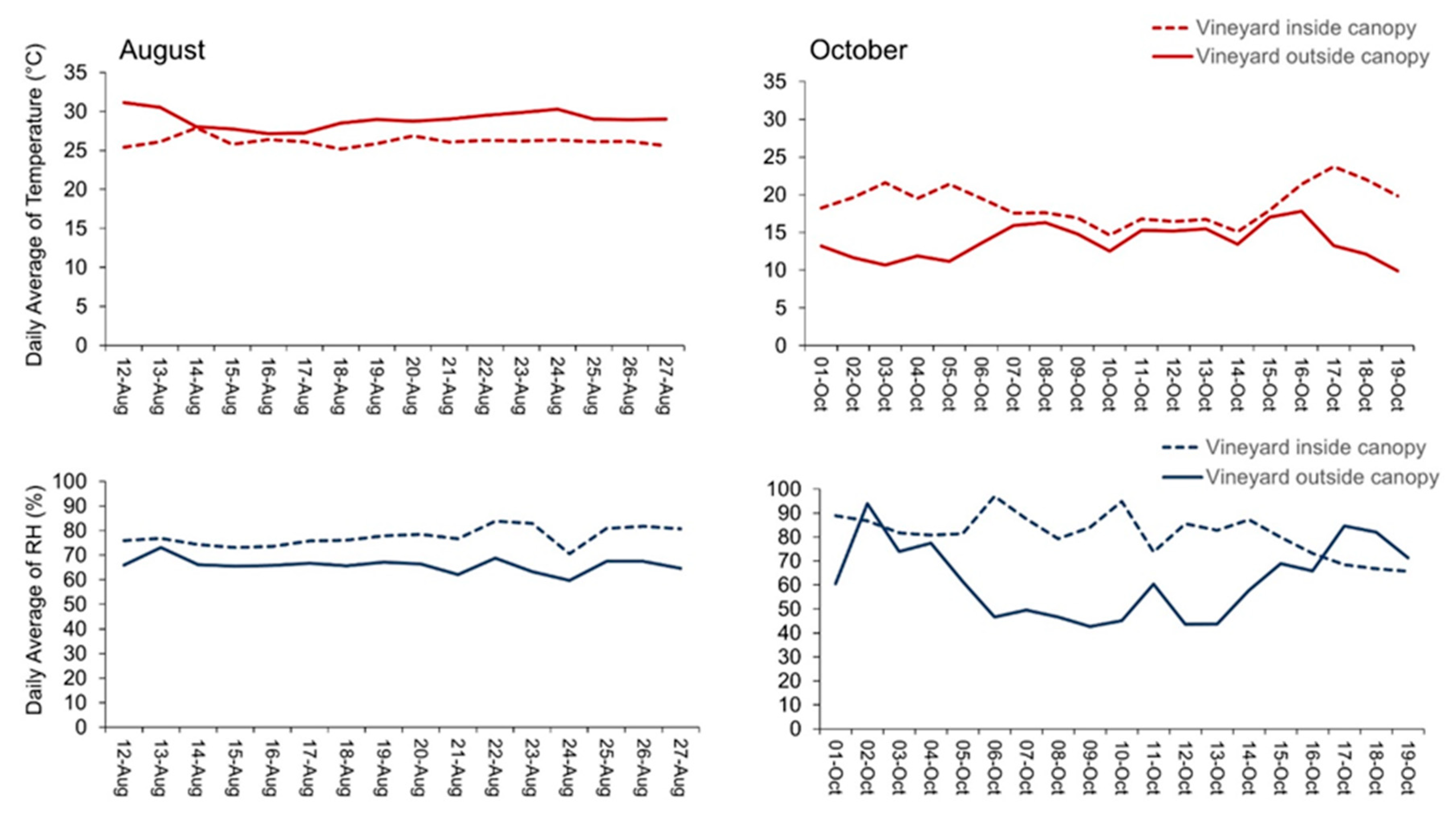
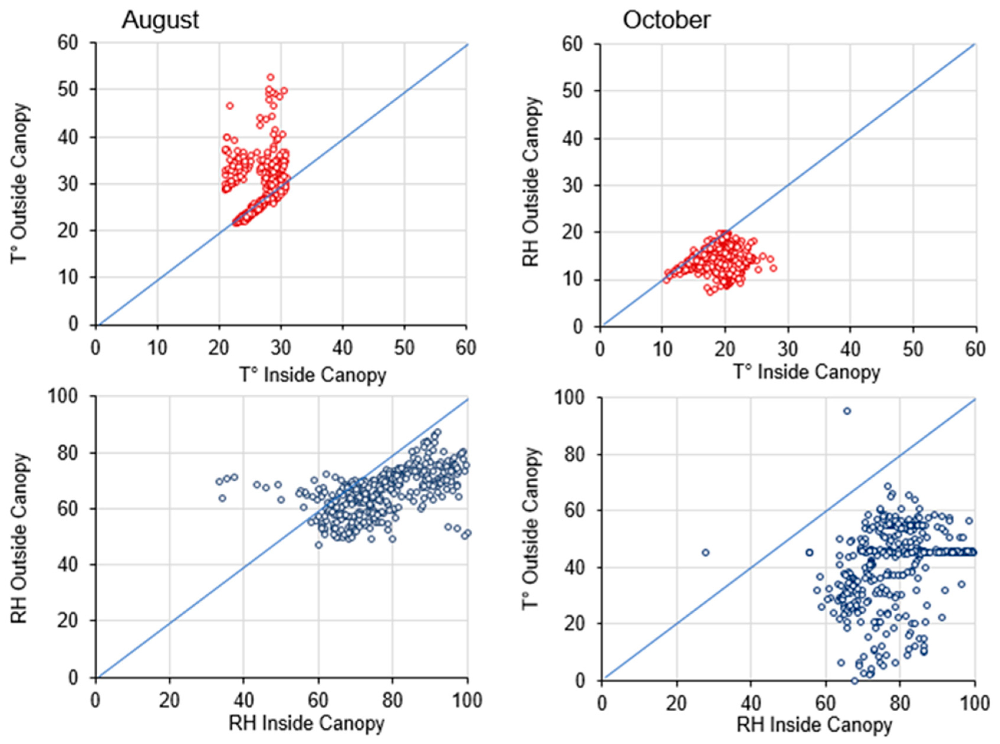
3.2. Field Test
4. Conclusions
Author Contributions
Funding
Conflicts of Interest
References
- Swain, K.C.; Jayasuriya, H.P.W.; Salokhe, V.M. Suitability of low-altitude remote sensing images for estimating nitrogen treatment variations in rice cropping for precision agriculture adoption. J. Appl. Remote Sens. 2007, 1, 013547. [Google Scholar] [CrossRef]
- Zhang, C.; Kovacs, J.M. The application of small unmanned aerial systems for precision agriculture: A review. Precis. Agric. 2012, 13, 693–712. [Google Scholar] [CrossRef]
- Lobell, D.B.; Schlenker, W.; Costa-Roberts, J. Climate trends and global crop production since 1980. Science 2011, 333, 616–620. [Google Scholar] [CrossRef]
- Gebbers, R.; Adamchuk, V.I. Precision Agriculture and Food Security. Science 2010, 327, 828–831. [Google Scholar] [CrossRef]
- Shibusawa, S. Precision Farming and Terra-mechanics. In Proceedings of the Fifth ISTVS Asia-Pacific Regional Conference, Seoul, Korea, 20–22 October 1998; pp. 20–22. [Google Scholar]
- Whelan, B.M.; McBratney, A.B.; Boydell, B.C. The Impact of Precision Agriculture. In Proceedings of the ABARE Outlook Conference, ‘The Future of Cropping in NW NSW’, Moree, UK, 15 July 1997; p. 5. [Google Scholar]
- Zhang, N.; Wang, M.; Wang, N. Precision agriculture—Worldwide overview. Comput. Electron. Agric. 2002, 36, 113–132. [Google Scholar] [CrossRef]
- Jannoura, R.; Brinkmann, K.; Uteau, D.; Bruns, C.; Joergensen, R.G. Monitoring of crop biomass using true colour aerial photographs taken from a remote controlled hexacopter. Biosyst. Eng. 2015, 129, 341–351. [Google Scholar] [CrossRef]
- Sugiura, R.; Noguchi, N.; Ishii, K. Remote—Sensing technology for vegetation monitoring using an unmanned helicopter. Biosyst. Eng. 2005, 90, 369–379. [Google Scholar] [CrossRef]
- Di Francesco, M.; Das, S.K.; Anastasi, G. Data collection in wireless sensor networks with mobile elements: A survey. ACM Trans. Sens. Netw. 2011, 8, 7. [Google Scholar] [CrossRef]
- Zhan, C.; Zeng, Y.; Zhang, R. Energy-efficient data collection in UAV enabled wireless sensor network. IEEE Wirel. Commun. Lett. 2017, 7, 328–331. [Google Scholar] [CrossRef]
- Simelli, I.; Tsagaris, A. The Use of Unmanned Aerial Systems (UAS) in Agriculture. In Proceedings of the 7th International Conference on Information and Communication Technologies in Agriculture, Food and Environment, Kavala, Greece, 17–20 September 2015. [Google Scholar]
- Stafford, J.V. Implementing precision agriculture in the 21st century. J. Agric. Eng. Res. 2000, 76, 267–275. [Google Scholar] [CrossRef]
- Price, P. Spreading the PA Message; Ground Cover, Issue 51 Grains Research and Development Corporation: Canberra, ACT, Australia, 2004. [Google Scholar]
- Robertson, M.; Carberry, P.; Brennan, L. The economic benefits of precision agriculture: Cast studies from Australia grain farms. Crop Pasture Sci. 2007, 60, 2012. [Google Scholar]
- Atzori, L.; Iera, A.; Morabito, G. The Internet of Things: A survey. Comput. Netw. 2010, 54, 2787–2805. [Google Scholar] [CrossRef]
- Gubbi, J.; Buyya, R.; Marusic, S. Palaniswami. Internet of Things (IoT): A vision, architectural elements, and future directions. Future Gener. Comput. Syst. 2013, 29, 1645–1660. [Google Scholar] [CrossRef]
- Kim, Y.; Evans, R.G.; Iversen, W.M. Remote sensing and control of an irrigation system using a distributed wireless sensor network. IEEE Trans. Instrum. Meas. 2008, 57, 1379–1387. [Google Scholar]
- Hernández, J.D.; Barrientos, J.; del Cerro, J.; Barrientos, A.; Sanz, D. Moisture measurement in crops using spherical robots. Ind. Robot Int. J. 2013, 40, 59–66. [Google Scholar] [CrossRef]
- Reiser, D.; Paraforos, D.S.; Khan, M.T.; Griepentrog, H.W.; Vázquez Arellano, M. Autonomous field navigation, data acquisition and node location in wireless sensor networks. Precis. Agric. 2017, 1, 1–14. [Google Scholar] [CrossRef]
- Wan, Y.; Schwaninger, H.; He, P.; Wang, Y. Comparison of resistance to powdery mildew and downy mildew in Chinese wild grapes. Vitis 2007, 46, 132–136. [Google Scholar]
- Geiger, R.; Aron, R.H.; Todhunter, P. The Climate Near the Ground; Rowman & Littlefield: Lanham, MD, USA, 2009; 623p. [Google Scholar]
- Hunziker, U.; Brang, P. Microsite patterns of conifer seedling establishment and growth in a mixed stand in the southern Alps. For. Ecol. Manag. 2005, 210, 67–79. [Google Scholar] [CrossRef]
- Mitscherlich, G. Wald, Wachstum und Umwelt: Waldklima und Wasserhaushalt [Forest Climate and Water Relations]; Sauerländer: Frankfurt am Main, Germany, 1981; Volume 2, 402p. [Google Scholar]
- Renaud, V.; Innes, J.L.; Dobbertin, M.; Rebetez, M. Comparison between open-site and below-canopy climatic conditions in Switzerland for different types of forests over 10 years (1998–2007). Theor. Appl. Clim. 2011, 105, 119–127. [Google Scholar] [CrossRef]
- Flemming, G. Wald—Wetter—Klima: Einführung in die Forstmeteorologie [Forest—Weather—Climate: An Introduction to Forest Meteorology]; Deutscher Landwirtschaftsverlag: Berlin, Germany, 1982. [Google Scholar]
- Shuttleworth, W.J.; Gash, J.H.C.; Lloyd, C.R.; Moore, C.J.; Roberts, J.; Filho, A.O.M.; Fisch, G.; Filho, S.V.P.; Ribeiro, M.N.G.; Molion, L.C.B.; et al. Daily variations of temperature and humidity within and above Amazonian forest. Weather 1985, 40, 102–108. [Google Scholar] [CrossRef]
- Miranda, R.A.C.; Milde, L.C.E.; Bichara, A.L.; Cornell, S. Daily characterisation of air temperature and relative humidity profiles in a cocoa plantation. Pesq. Agropec. Bras. 1994, 29, 345–353. [Google Scholar]
- Von Arx, G.; Dobbertin, M.; Rebetez, M. Spatio-temporal effects of forest canopy on understory microclimate in a long-term experiment in Switzerland. Agric. Meteorol. 2012, 167, 144–155. [Google Scholar] [CrossRef]
- Petr, J. Weather and Yield; Dev Crop Sci. N. 20; Elsevier: Amsterdam, The Netherlands, 1991; p. 288. [Google Scholar]
- Fageria, N.K. Maximizing Crop Yields; Marcel Dekker: New York, NY, USA, 1992. [Google Scholar]
- Hoogenboom, G. Contribution of agrometeorology to the simulation of crop production and its applications. Agric. For. Meteorol. 2000, 103, 137–157. [Google Scholar] [CrossRef]
- Bunting, A.H. Time, phenology and the yields of crops. Weather 1975, 30, 312–325. [Google Scholar] [CrossRef]
- Stigter, C.J. Microclimate Management and Manipulation in Traditional Farming; CAgM Report No. 25, WMO/TD-No. 228; World Meteorological Organization: Geneva, Switzerland, 1988; p. 20. [Google Scholar]
- Stigter, C.J.; Karing, P.H.; Stigter, C.J.; Chen, W.; Wilken, G.C. Application of Microclimate Management and Manipulation Techniques in Low External Input Agriculture; CAgM Report No. 43, WMO/TD-No. 499; World Meteorological Organization: Geneva, Switzerland, 1992; p. 192. [Google Scholar]
- Olufayo, A.A.; Stigter, C.J.; Baldy, C. On needs and deeds in agrometeorology in tropical Africa. Agric. For. Meteorol. 1998, 92, 227–240. [Google Scholar] [CrossRef]
- Hodges, T. (Ed.) Predicting Crop Phenology; CRC Press: Boca Raton, FL, USA, 1991. [Google Scholar]
- Rezník, T.; Lukas, V.; Charvát, K.; Charvát, K., Jr.; Krivánek, Z.; Kepka, M.; Herman, L.; Rezníková, H. Disaster Risk Reduction in Agriculture through Geospatial (Big) Data Processing. Int. J. Geo-Inf. 2017, 6, 238. [Google Scholar]

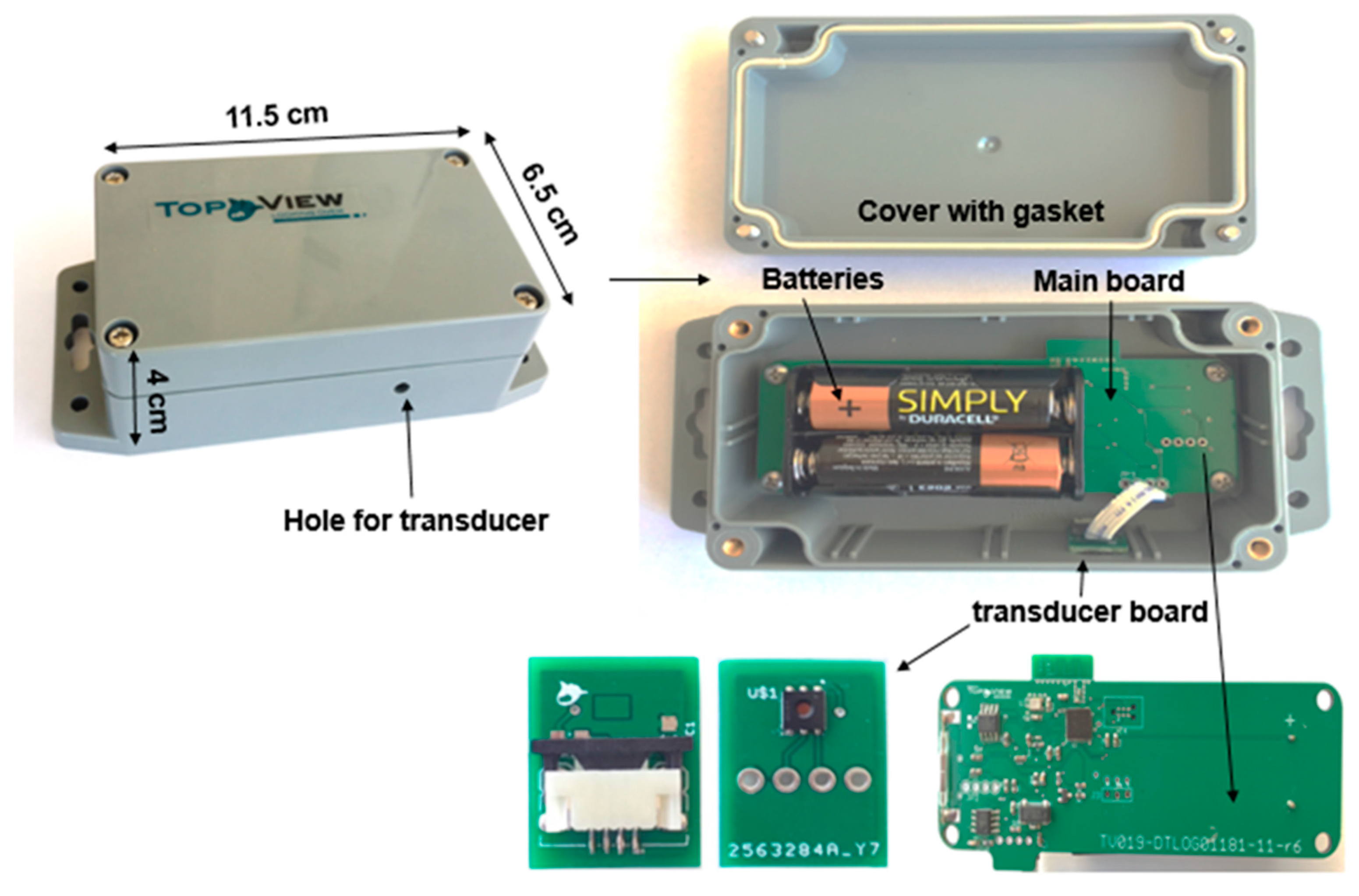
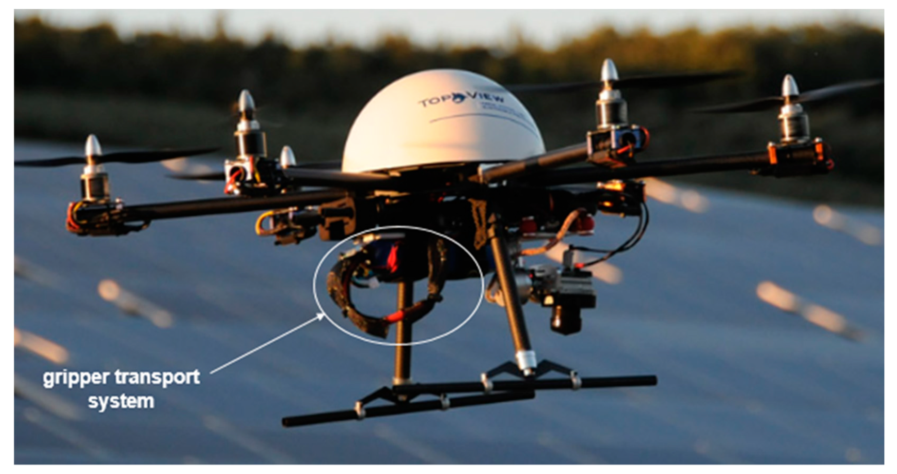
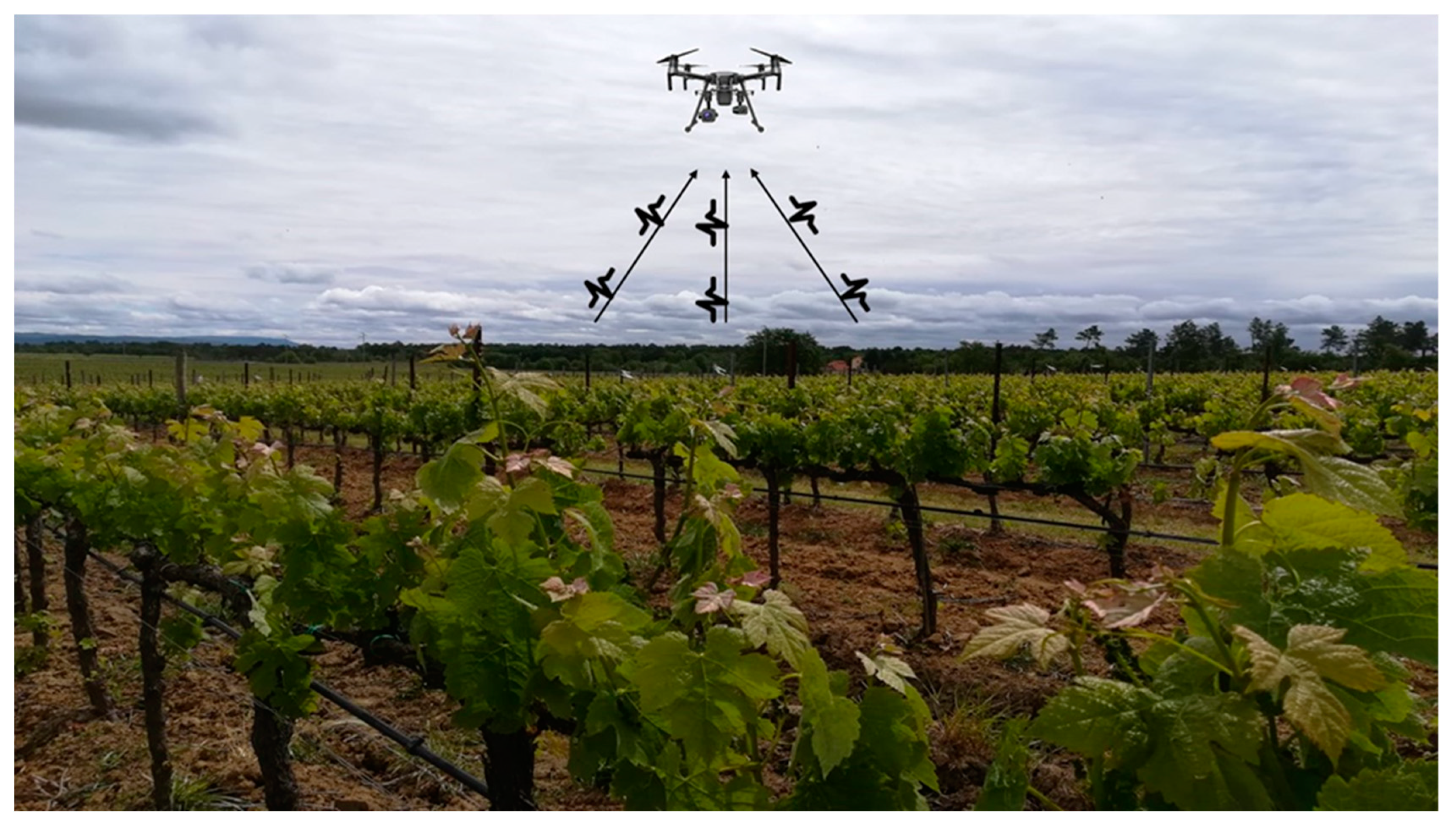
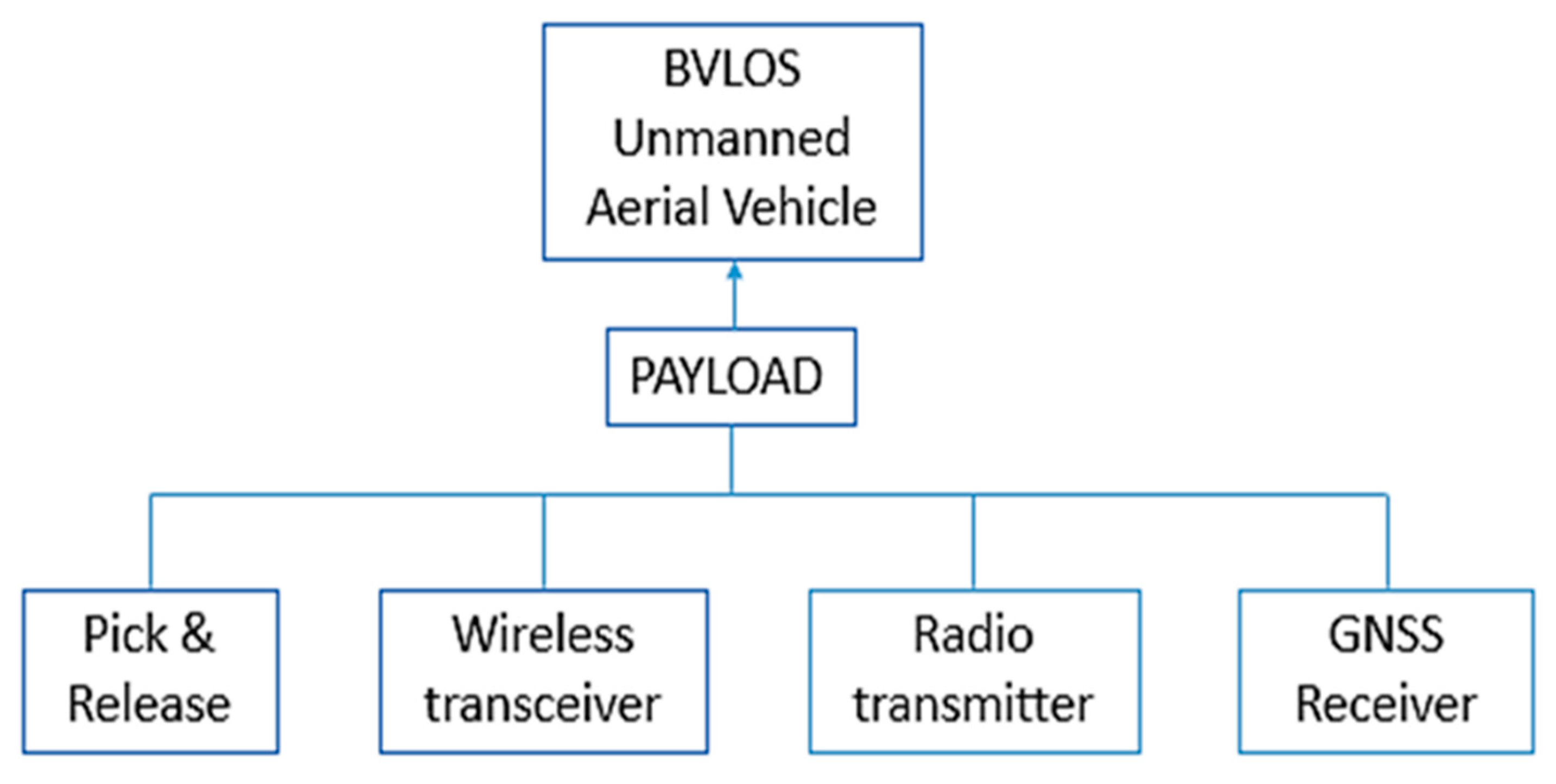

| AA Duracell Plus Battery Specification | ||
|---|---|---|
| Parameter | Value | Conditions |
| Voltage | 1.5 V | 1A load |
| Capacity | 2.000 mAh | 10 m A load |
| Self-Discharge | 0.5% Per month | 20 °C |
| Device Elements | Operating Mode | ||
|---|---|---|---|
| Sleep | Upload | Sampling | |
| Microcomputer | 2.3 μA | 7.8 mA | 2.0 mA |
| Data logger | 0.1 μA | 400 μA | 400 μA |
| Real-time clock | 1.2 μA | 1.2 μA | 400 μA |
| Wake-up circuit | 0.8 μA | 0.8 μA | 0.8 μA |
| Power module | 0.0 μA | 100 μA | 0.0 μA |
| Transducer module | 60 nA | 150 μA | 150 μA |
| Cumulative current | 4.5 μA | 9.65 mA | 2.95 mA |
| Setup Values | ||
|---|---|---|
| Parameter | Value | Notes |
| Sampling time interval | 1 h | - |
| Sample collection time | 2 s | Average value of 10 samples |
| Upload time interval | 168 h | 1 week |
| Upload duration | 10 s | 9600 baud |
| Overall consumption | 1.04 mAh | In one week |
© 2020 by the authors. Licensee MDPI, Basel, Switzerland. This article is an open access article distributed under the terms and conditions of the Creative Commons Attribution (CC BY) license (http://creativecommons.org/licenses/by/4.0/).
Share and Cite
Idbella, M.; Iadaresta, M.; Gagliarde, G.; Mennella, A.; Mazzoleni, S.; Bonanomi, G. AgriLogger: A New Wireless Sensor for Monitoring Agrometeorological Data in Areas Lacking Communication Networks. Sensors 2020, 20, 1589. https://doi.org/10.3390/s20061589
Idbella M, Iadaresta M, Gagliarde G, Mennella A, Mazzoleni S, Bonanomi G. AgriLogger: A New Wireless Sensor for Monitoring Agrometeorological Data in Areas Lacking Communication Networks. Sensors. 2020; 20(6):1589. https://doi.org/10.3390/s20061589
Chicago/Turabian StyleIdbella, Mohamed, Mariano Iadaresta, Graziano Gagliarde, Alberto Mennella, Stefano Mazzoleni, and Giuliano Bonanomi. 2020. "AgriLogger: A New Wireless Sensor for Monitoring Agrometeorological Data in Areas Lacking Communication Networks" Sensors 20, no. 6: 1589. https://doi.org/10.3390/s20061589
APA StyleIdbella, M., Iadaresta, M., Gagliarde, G., Mennella, A., Mazzoleni, S., & Bonanomi, G. (2020). AgriLogger: A New Wireless Sensor for Monitoring Agrometeorological Data in Areas Lacking Communication Networks. Sensors, 20(6), 1589. https://doi.org/10.3390/s20061589


