Extrinsic LiDAR/Ground Calibration Method Using 3D Geometrical Plane-Based Estimation
Abstract
1. Introduction
1.1. Overview
1.2. Related Works
1.3. Proposed Method
2. LiDAR/Ground Geometrical Impact Modeling
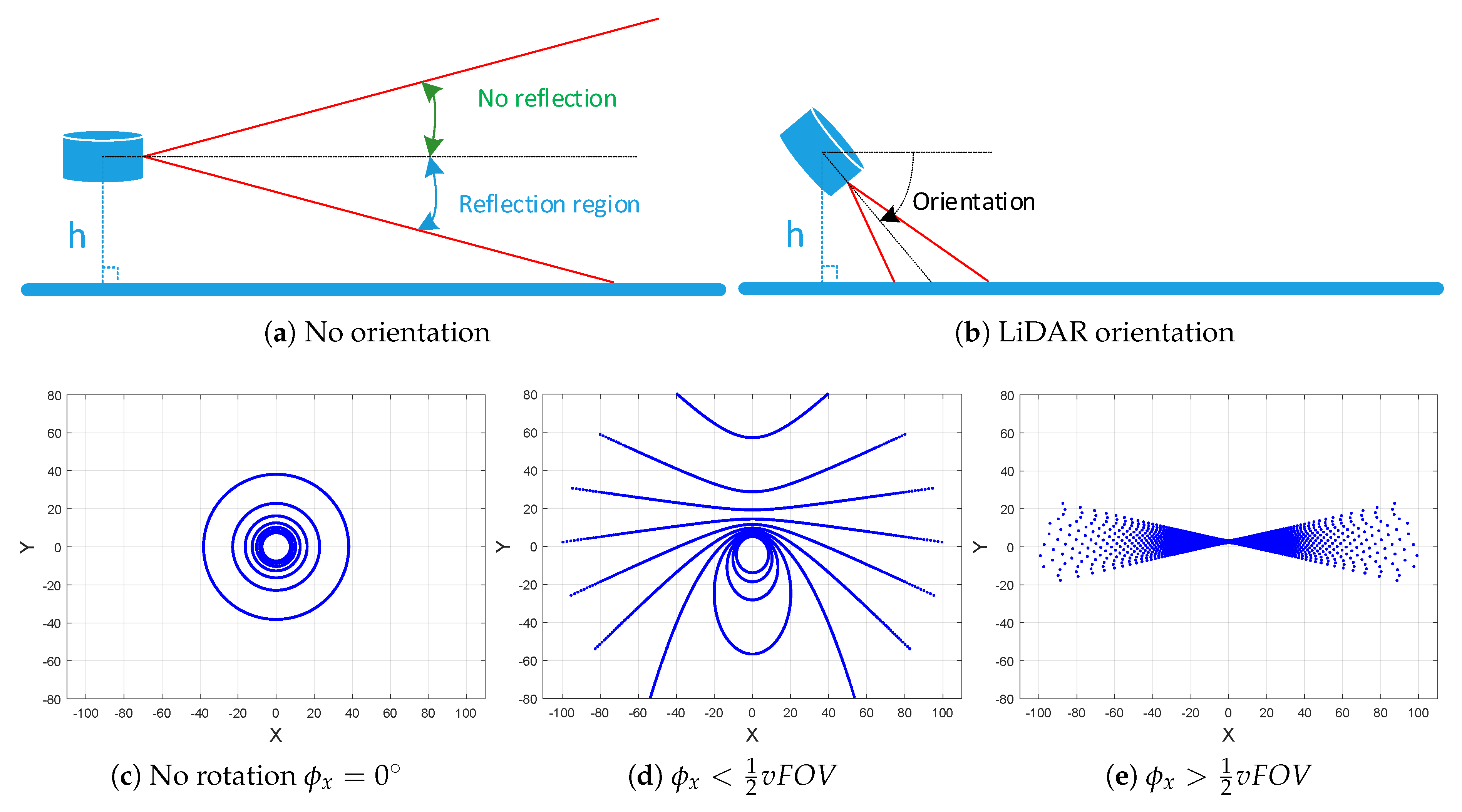
- Practical orientation concept: The LiDAR laser beams are supposed to be rotated and the ground’s real plane is a fixed horizontal plane, as shown in Figure 1b.
- Scientific orientation concept: The LiDAR laser beams are supposed to be fixed and the virtual horizontal ground surface must be rotated by the LiDAR’s inverse orientation in the practical concept, to get the real oblique ground plane in LiDAR frame, as shown in Figure 1c.
2.1. Extrinsic Parameters vs. Practical Concept
- Goal: The plane-based extrinsic calibration needs large sparsity area to improve the plane estimation, which requires high altitude and low orientation angles.
- Constraint: The stated finality of road surface object detection needs high density points to improve the capability of defect coverage points, which requires low altitude and high orientation angles.
2.2. LiDAR Laser Beams and Oblique Ground Surface Intersection
2.3. Error Modeling in Polar and Cartesian Coordinates
3. LiDAR/Ground Extrinsic Calibration Method
3.1. Fitting Plane
3.2. Rotation about Axis
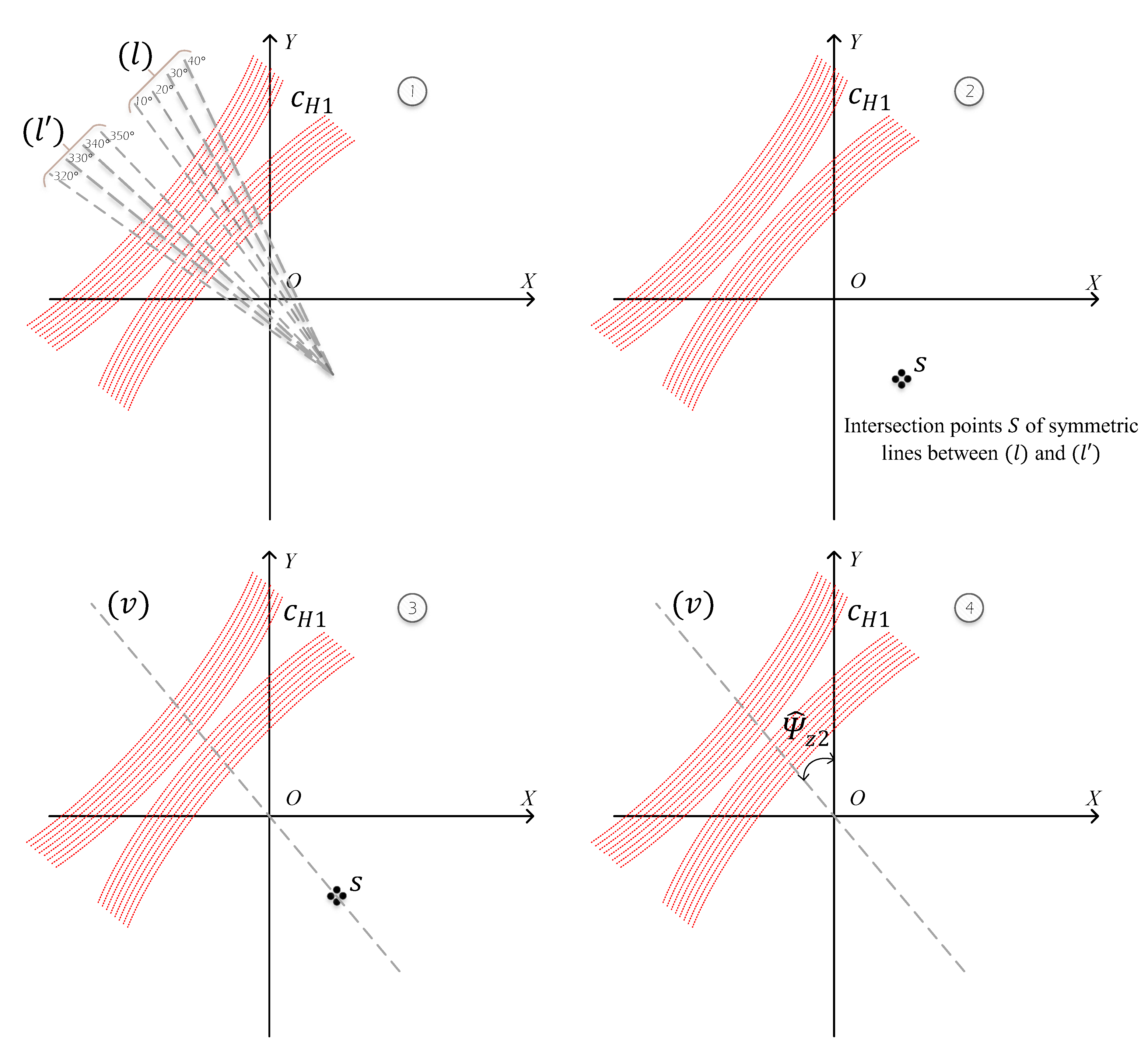
3.3. Yaw Angle Estimation
| Algorithm 1: Least Squares Conic Algorithm. |
| Input: x,y,z,, of the distributed points Output:
|
3.4. Height Estimation
3.5. Extrinsic Parameters Optimization
4. Experimental Results
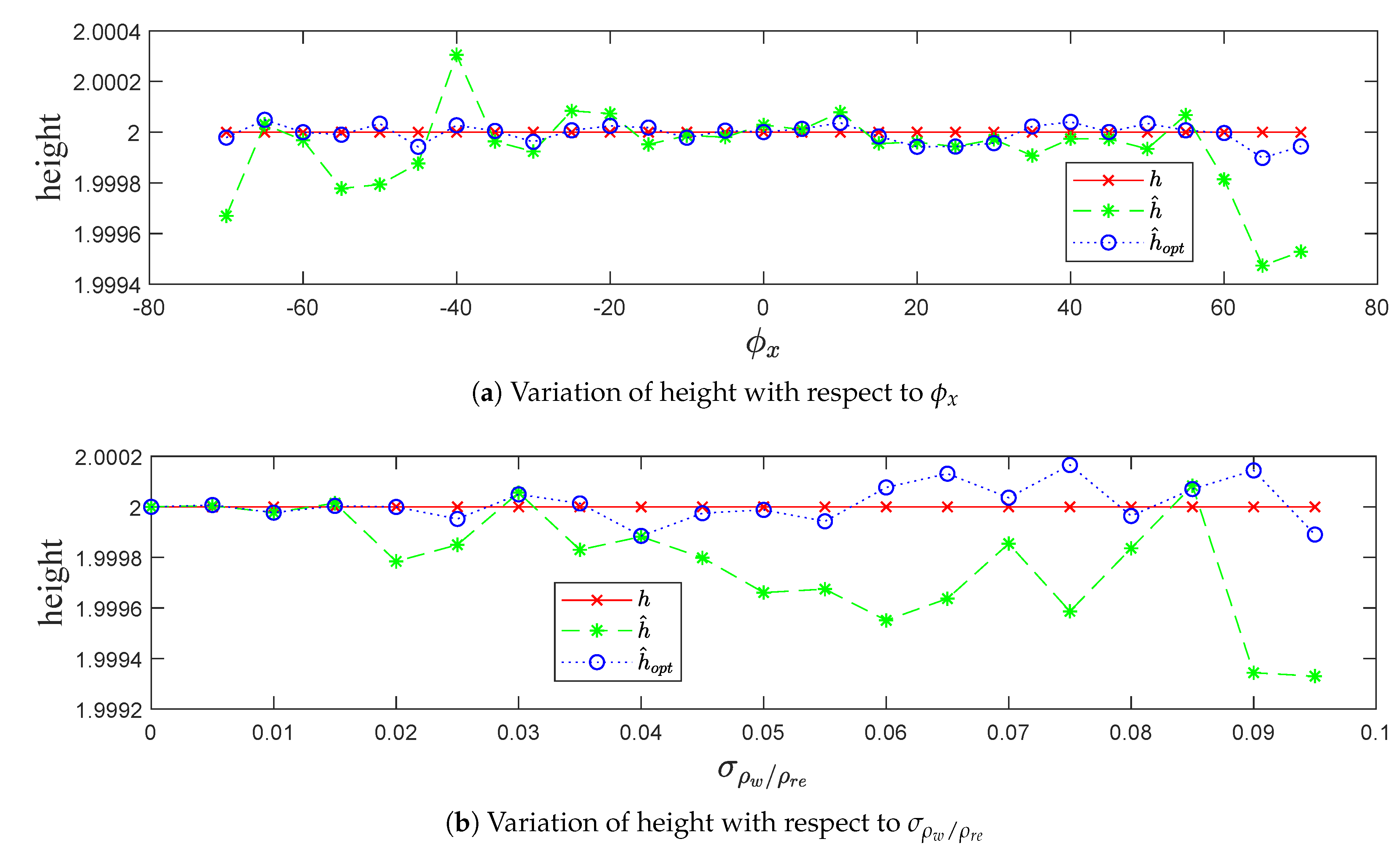
- The real height h, estimated height , and the optimized height .
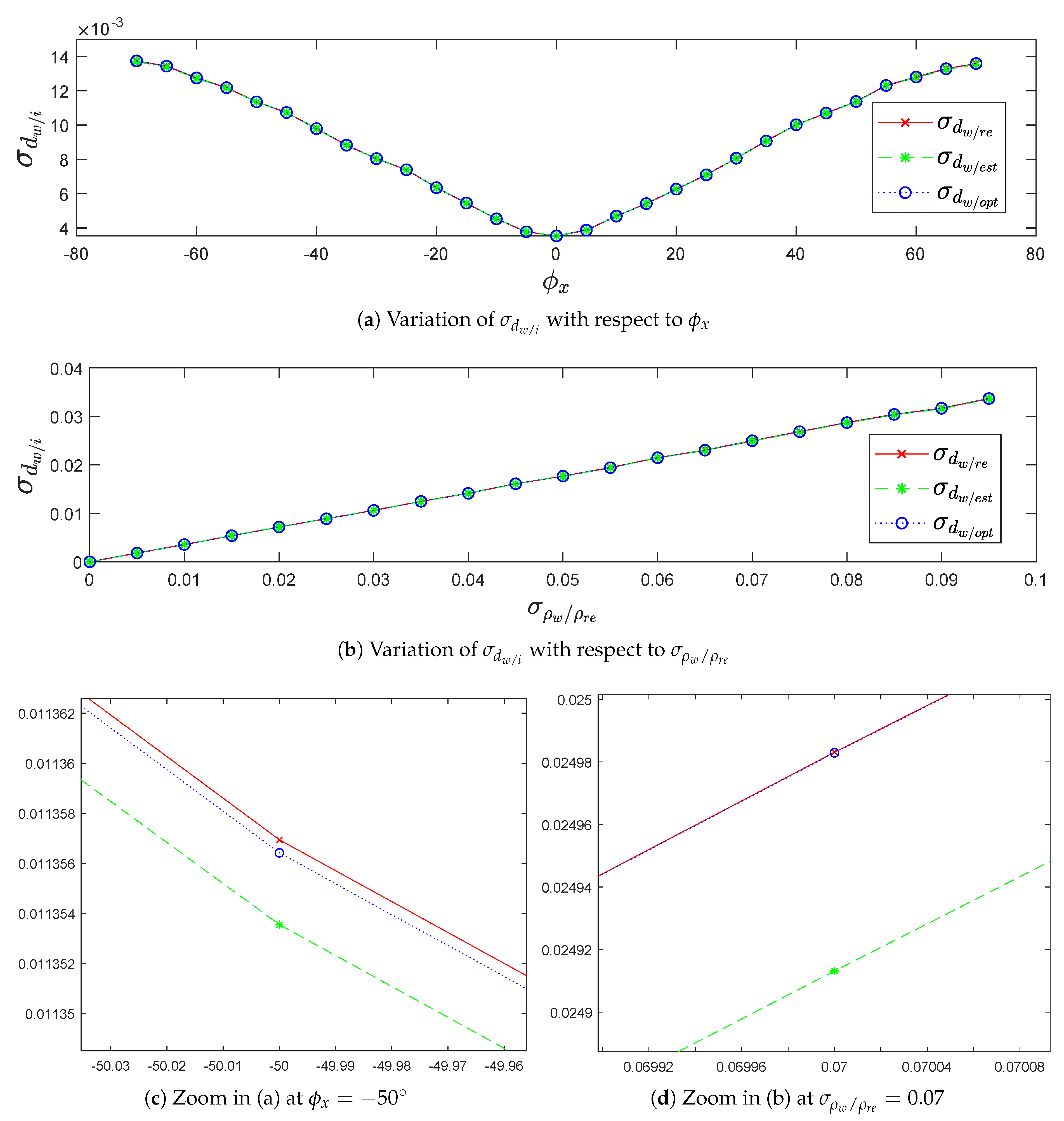
- The standard deviation of the noisy points orthogonal Euclidean distance with respect to the real plane , the estimated plane and the optimized plane .where are the Cartesian coordinates of the noisy points , are the coefficient parameters of the planes, , and N is the number of impact points.
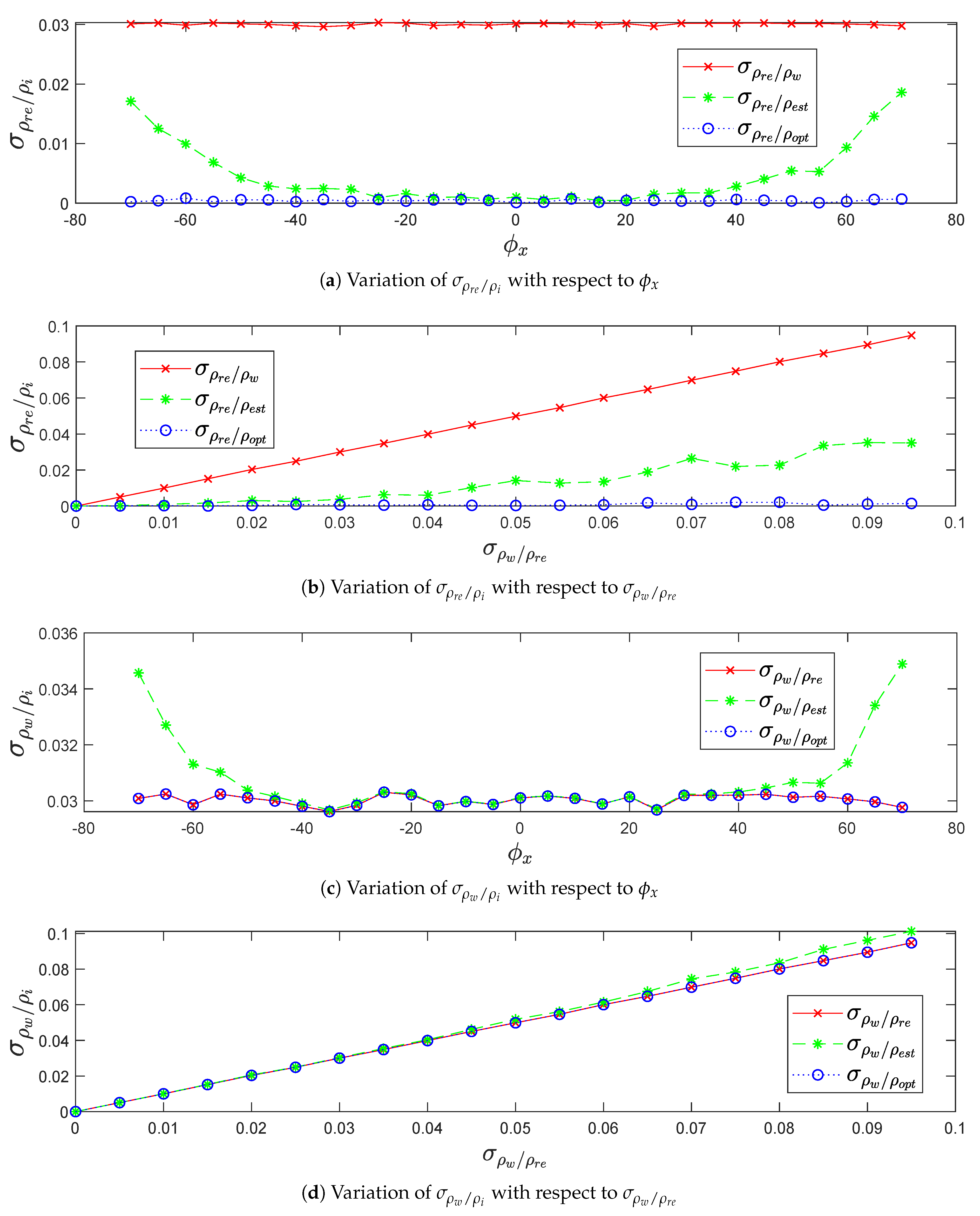
- The standard deviation of the real points range difference with respect to the noisy points , the estimated points , and the optimized points .where and N is the number of impact points.
- The standard deviation of the noisy points range difference with respect to the real points , the estimated points , and the optimized points .where and N is the number of impact points.
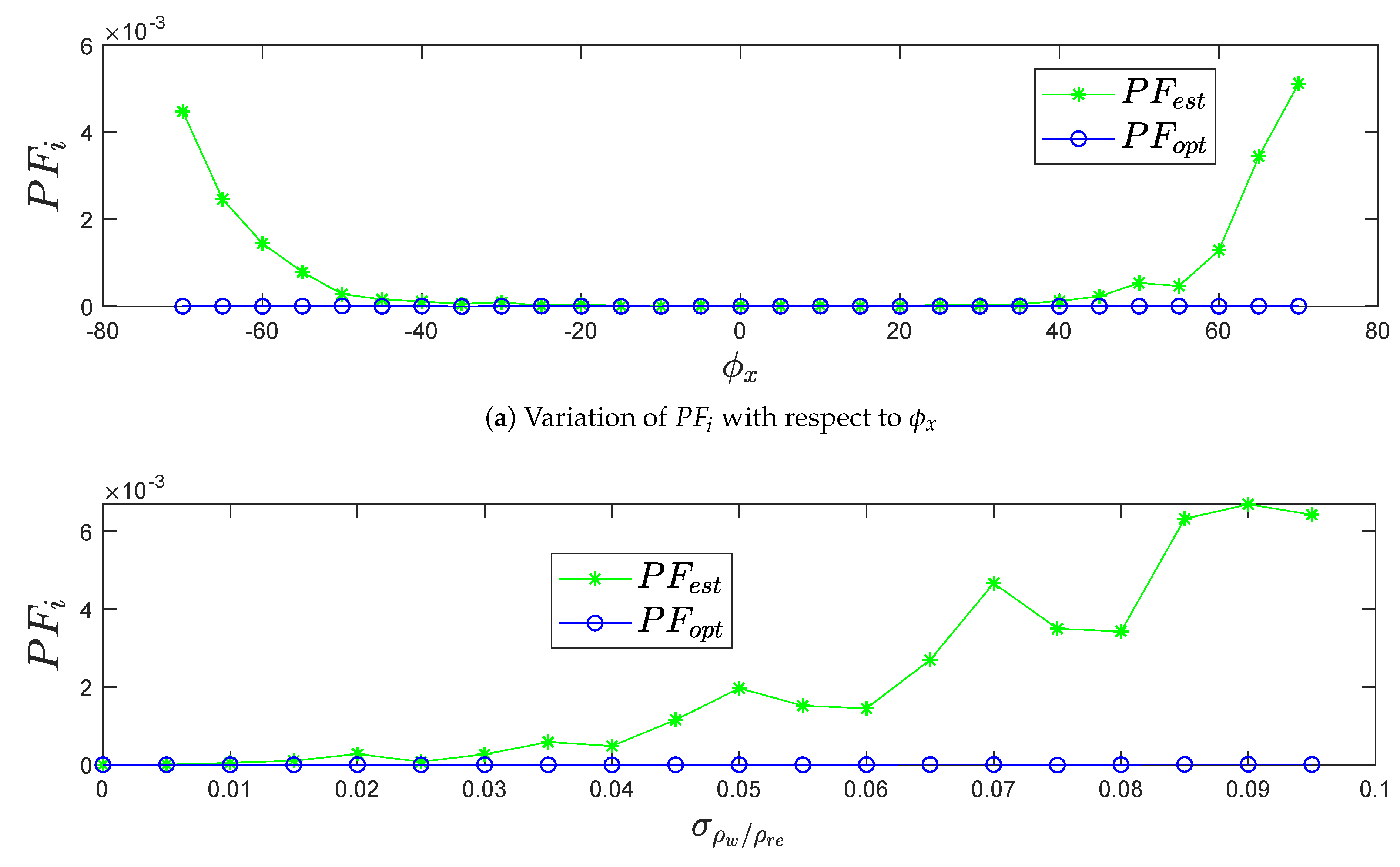
- The gain in performance that describes the range accuracy enhancement obtained from the Levenberg–Marquardt optimization algorithm which is defined as:where is the LiDAR range accuracy and .
4.1. Simulation Data Results
- In term of precision, the real height , roll angle , yaw angle , and LiDAR range accuracy , with respect to the variation of pitch angle .
- In term of robustness, the real height , pitch angle , roll angle , and yaw angle , with respect to the variation of .
4.1.1. Standard Deviation in Terms of Precision and Robustness
4.1.2. Standard Deviation and in Terms of Precision and Robustness
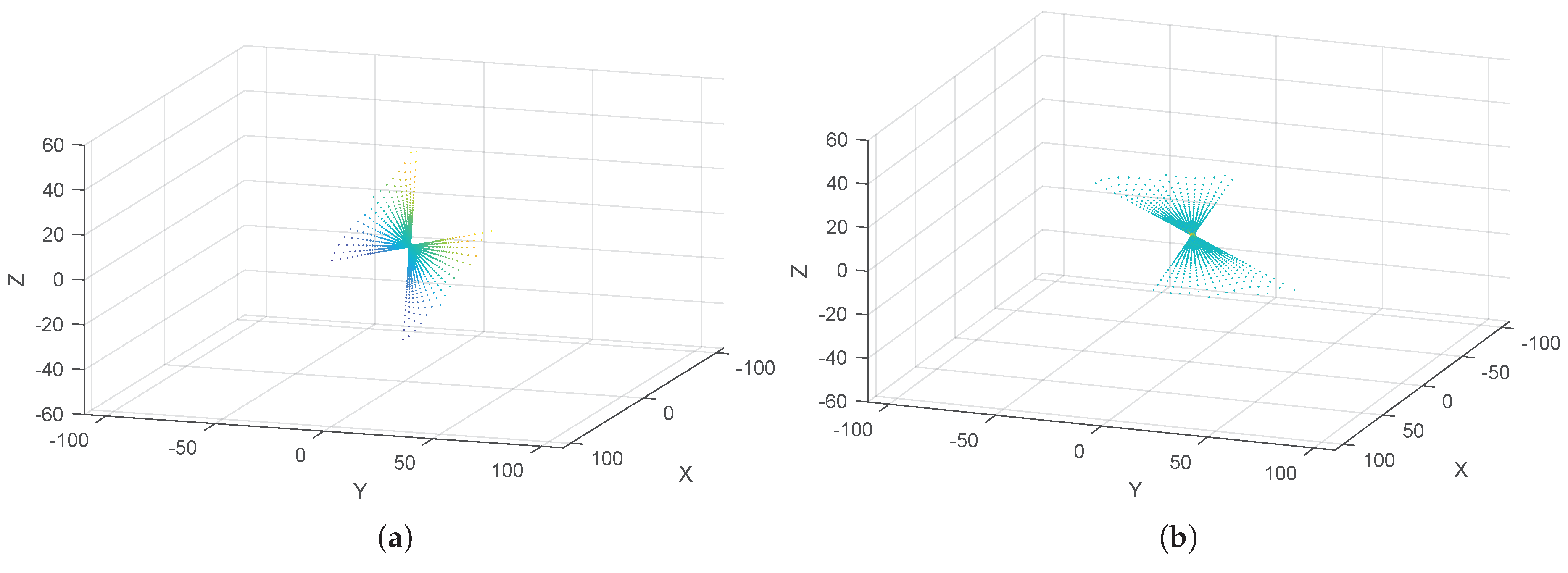
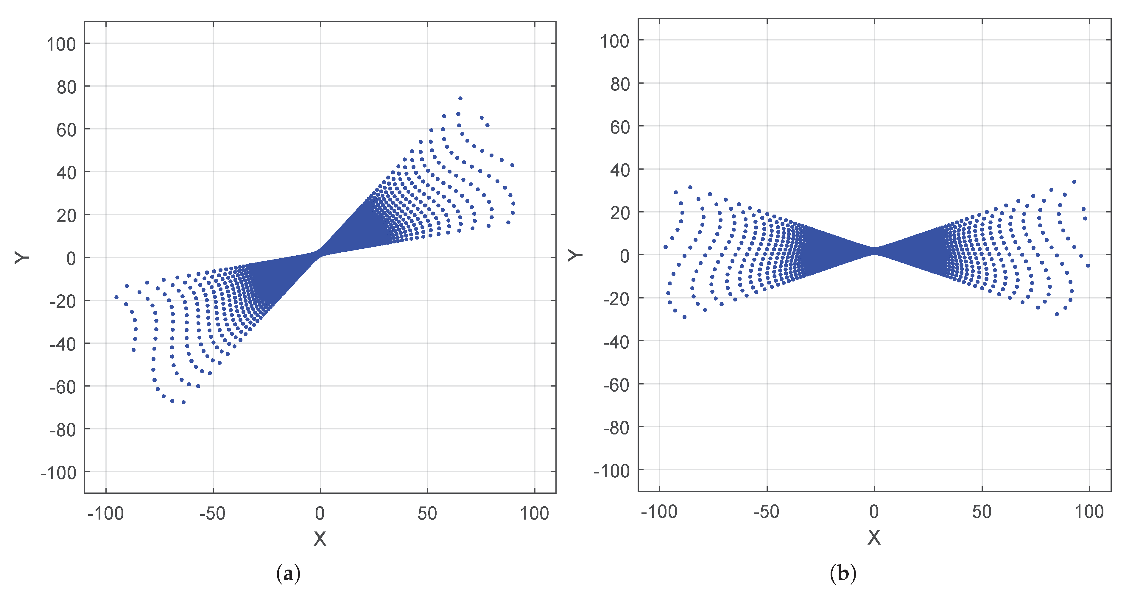
- The increase of pitch angle on positive and negative sides decreases the sparsity of impact points on the ground. This leads to decrease the precision of plane fitting estimation, as shown in Figure 8a,c.
- The increase of LiDAR range accuracy decreases the precision of plane fitting estimation, as shown in Figure 8b,d.
4.1.3. Height Recovering in Terms of Precision and Robustness
4.1.4. Performance Gain in Terms of Precision and Robustness
4.2. Real Data Results
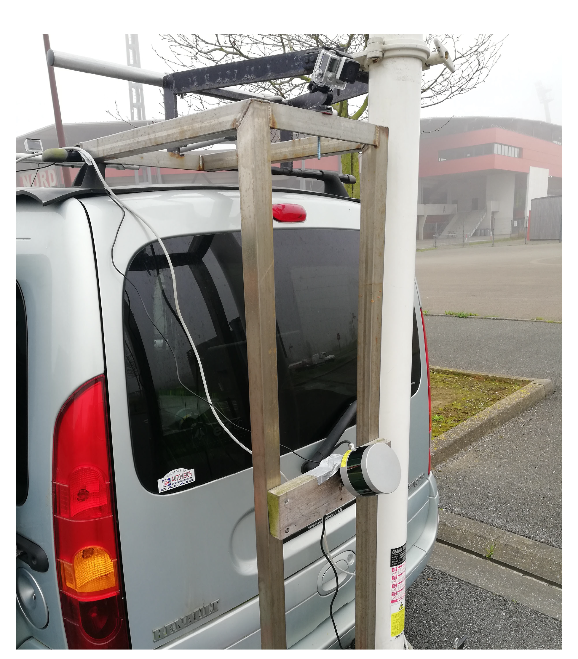
- Acquisition 1: The vehicle was at rest on the road.
- Acquisition 2: The vehicle was moving at a slow speed on the road.
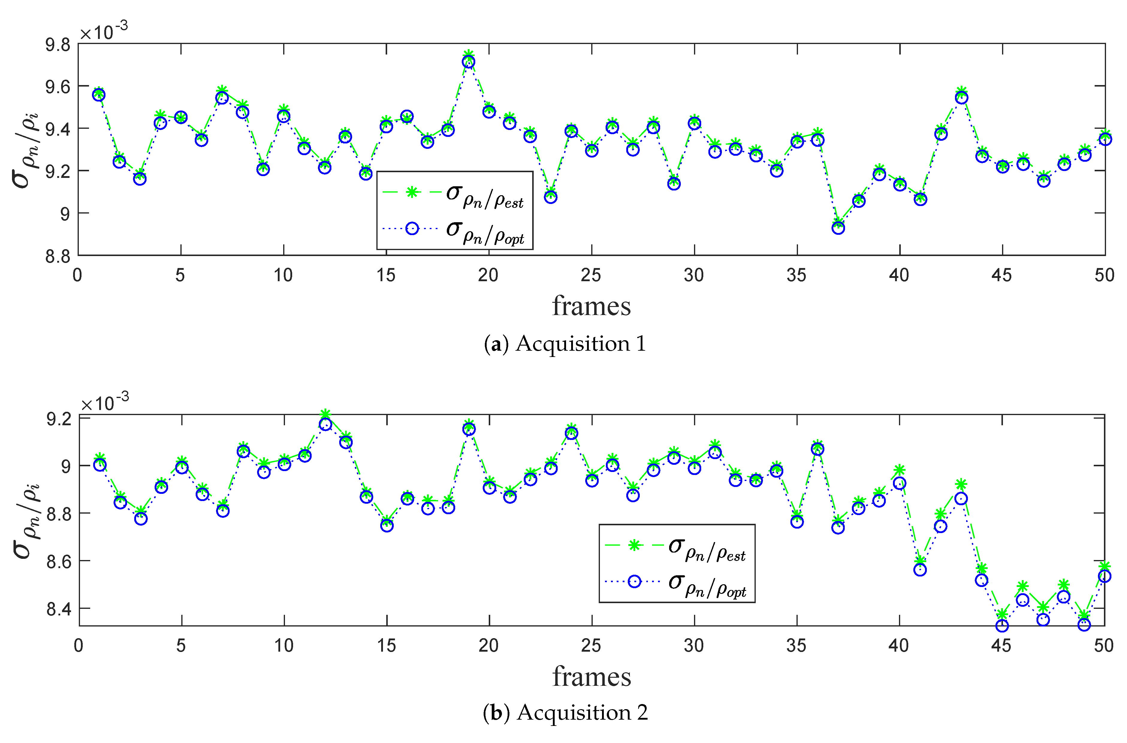
Standard Deviation per LiDAR Frames
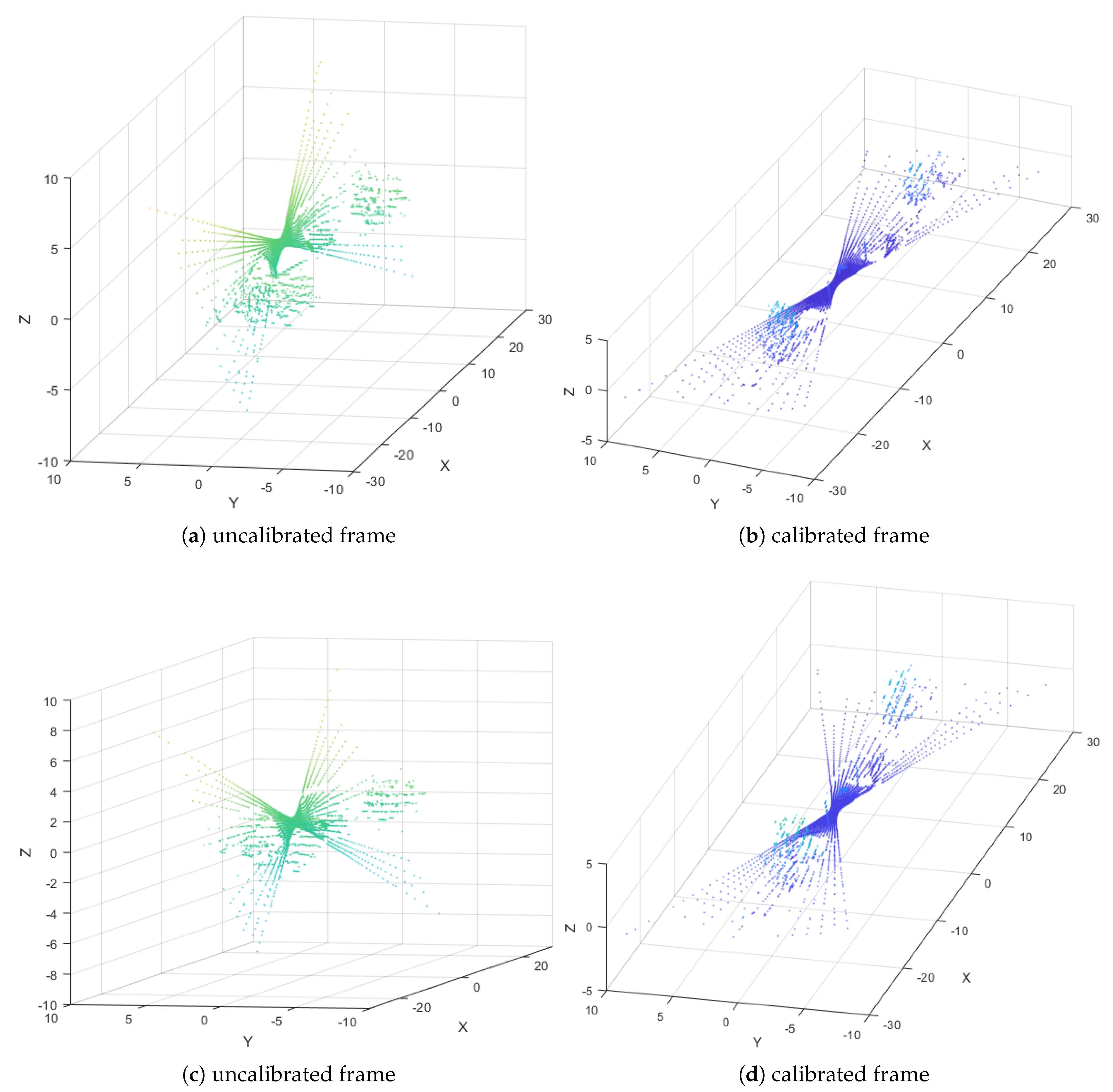
4.3. Results Discussion
5. Conclusions
Author Contributions
Funding
Conflicts of Interest
References
- Coenen, T.B.; Golroo, A. A review on automated pavement distress detection methods. Cogent Eng. 2017, 4, 1374822. [Google Scholar] [CrossRef]
- Fortin, B.; Lherbier, R.; Noyer, J. A Model-Based Joint Detection and Tracking Approach for Multi-Vehicle Tracking With Lidar Sensor. IEEE Trans. Intell. Transp. Syst. 2015, 16, 1883–1895. [Google Scholar] [CrossRef]
- Lenac, K.; Kitanov, A.; Cupec, R.; PetroviÄ, I. Fast planar surface 3D SLAM using LIDAR. Robot. Auton. Syst. 2017, 92, 197–220. [Google Scholar] [CrossRef]
- Liang, X.; Chen, H.; Li, Y.; Liu, Y. Visual laser-SLAM in large-scale indoor environments. In Proceedings of the 2016 IEEE International Conference on Robotics and Biomimetics (ROBIO), Qingdao, China, 3–7 December 2016; pp. 19–24. [Google Scholar] [CrossRef]
- Fernandes, R.; Premebida, C.; Peixoto, P.; Wolf, D.; Nunes, U. Road Detection Using High Resolution LIDAR. In Proceedings of the IEEE Vehicle Power and Propulsion Conference (VPPC), 27–30 October 2014; pp. 1–6. [Google Scholar] [CrossRef]
- Zhang, W. LIDAR-based road and road-edge detection. In Proceedings of the 2010 IEEE Intelligent Vehicles Symposium, La Jolla, CA, USA, 21–24 June 2010; pp. 845–848. [Google Scholar] [CrossRef]
- Yutong, Y.; Liming, F.; Bijun, L. Object detection and tracking using multi-layer laser for autonomous urban driving. In Proceedings of the 2016 IEEE 19th International Conference on Intelligent Transportation Systems (ITSC), Janeiro, Brazil, 1–4 November 2016; pp. 259–264. [Google Scholar] [CrossRef]
- Li, Q.; Zhang, L.; Mao, Q.; Zou, Q.; Zhang, P.; Feng, S.; Ochieng, W. Motion Field Estimation for a Dynamic Scene Using a 3D LiDAR. Sensors 2014, 14, 16672–16691. [Google Scholar] [CrossRef] [PubMed]
- Cho, M. A Study on the Obstacle Recognition for Autonomous Driving RC Car Using LiDAR and Thermal Infrared Camera. In Proceedings of the 2019 Eleventh International Conference on Ubiquitous and Future Networks (ICUFN), Zagreb, Croatia, 2–5 July 2019; pp. 544–546. [Google Scholar] [CrossRef]
- Nagashima, T.; Nagasaki, T.; Matsubara, H. Object Recognition Method Commonly Usable for LIDARs With Different Vertical Resolution. In Proceedings of the 2018 IEEE 7th Global Conference on Consumer Electronics (GCCE), Nara, Japan, 9–12 October 2018; pp. 751–753. [Google Scholar] [CrossRef]
- Yang, S.; Fan, Y. 3D Building Scene Reconstruction Based on 3D LiDAR Point Cloud. In Proceedings of the 2017 IEEE International Conference on Consumer Electronics—Taiwan (ICCE-TW), Ilan, Taiwan, 20–22 May 2019; pp. 127–128. [Google Scholar] [CrossRef]
- Qi, J.; Gastellu-Etchegorry, J.P.; Yin, T. Reconstruction of 3D Forest Mock-Ups from Airborne LiDAR Data for Multispectral Image Simulation Using DART Model. In Proceedings of the IGARSS 2018—2018 IEEE International Geoscience and Remote Sensing Symposium, Valencia, Spain, 22–27 July 2018; pp. 3975–3978. [Google Scholar] [CrossRef]
- Clifton, W.E.; Steele, B.; Nelson, G.; Truscott, A.; Itzler, M.; Entwistle, M. Medium altitude airborne Geiger-mode mapping LIDAR system. In Laser Radar Technology and Applications XX; and Atmospheric Propagation XII; Turner, M.D., Kamerman, G.W., Thomas, L.M.W., Spillar, E.J., Eds.; International Society for Optics and Photonics, SPIE: Bellingham, DC, USA, 2015; Volume 9465, pp. 39–46. [Google Scholar] [CrossRef]
- Behringer, R.; Sundareswaran, S.; Gregory, B.; Elsley, R.; Addison, B.; Guthmiller, W.; Daily, R.; Bevly, D. The DARPA grand challenge - development of an autonomous vehicle. IEEE Intell. Veh. Symp. 2004, 2004, 226–231. [Google Scholar] [CrossRef]
- Owechko, Y.; Medasani, S.; Korah, T. Automatic recognition of diverse 3-D objects and analysis of large urban scenes using ground and aerial LIDAR sensors. In Proceedings of the CLEO/QELS: 2010 Laser Science to Photonic Applications, San Jose, CA, USA, 16–21 May 2010; pp. 1–2. [Google Scholar] [CrossRef]
- Thrun, S. Winning the DARPA Grand Challenge. In Machine Learning: ECML 2006; Fürnkranz, J., Scheffer, T., Spiliopoulou, M., Eds.; Springer: Berlin/Heidelberg, Germany, 2006; p. 4. [Google Scholar]
- Buehler, M.; Iagnemma, K.; Singh, S. Special issue on the 2007 DARPA Urban Challenge, Part II. J. Field Robot. 2008, 25, 567–568. [Google Scholar] [CrossRef]
- Muhammad, N.; Lacroix, S. Calibration of a rotating multi-beam lidar. In Proceedings of the 2010 IEEE/RSJ International Conference on Intelligent Robots and Systems, Taipei, Taiwan, 18–22 October 2010; pp. 5648–5653. [Google Scholar] [CrossRef]
- Glennie, C.; Lichti, D.D. Static Calibration and Analysis of the Velodyne HDL-64E S2 for High Accuracy Mobile Scanning. Remote Sens. 2010, 2, 1610–1624. [Google Scholar] [CrossRef]
- Glennie, C.; Kusari, A.; Facchin, A. Calibration and stability analysis of the VLP-16 laser scanner. ISPRS Int. Arch. Photogramm. Remote. Sens. Spat. Inf. Sci. 2016, XL-3/W4, 55–60. [Google Scholar] [CrossRef]
- Zeng, Y.; Yu, H.; Dai, H.; Song, S.; Lin, M.; Sun, B.; Jiang, W.; Meng, M.Q.H. An Improved Calibration Method for a Rotating 2D LIDAR System. Sensors 2018, 18. [Google Scholar] [CrossRef] [PubMed]
- Kurnianggoro, L.; Dung, H.V.; Jo, K.H. Calibration of a 2D Laser Scanner System and Rotating Platform using a Point-Plane Constraint. Comput. Sci. Inf. Syst. 2015, 12, 307–322. [Google Scholar] [CrossRef]
- Atanacio-Jiménez, G.; González-Barbosa, J.; Hurtado-Ramos, J.; Ornelas-Rodríguez, F.; Jiménez-Hernández, H.; García-Ramirez, T.; González-Barbosa, R. LIDAR velodyne HDL-64E calibration using pattern planes. Int. J. Adv. Robot. Syst. 2011, 8, 59. [Google Scholar] [CrossRef]
- Levinson, J.; Thrun, S. Unsupervised calibration for multi-beam lasers. In Experimental Robotics; Springer: Berlin/Heidelberg, Germany, 2014; pp. 179–193. [Google Scholar]
- Zaiter, M.A.; Lherbier, R.; Faour, G.; Bazzi, O.; Noyer, J.C. 3D LiDAR Extrinsic Calibration Method using Ground Plane Model Estimation. In Proceedings of the IEEE 8th International Conference on Connected Vehicles and Expo (ICCVE), Graz, Austria, 4–8 November 2019. [Google Scholar]
- Taubin, G. 3D Rotations. IEEE Comput. Graph. Appl. 2011, 31, 84–89. [Google Scholar] [CrossRef] [PubMed]
- Duc-Hung, L.; Cong-Kha, P.; Trang, N.T.T.; Tu, B.T. Parameter extraction and optimization using Levenberg-Marquardt algorithm. In Proceedings of the Fourth International Conference on Communications and Electronics (ICCE), Hue, Vietnam, 1–3 August 2012; pp. 434–437. [Google Scholar] [CrossRef]


| Features | VLP-16 |
|---|---|
| Laser beams | 16 |
| Horizontal FOV | |
| Vertical FOV | |
| Azimuth angular resolution | |
| Elevation angular resolution | |
| Maximum range accuracy |
© 2020 by the authors. Licensee MDPI, Basel, Switzerland. This article is an open access article distributed under the terms and conditions of the Creative Commons Attribution (CC BY) license (http://creativecommons.org/licenses/by/4.0/).
Share and Cite
Zaiter, M.A.; Lherbier, R.; Faour, G.; Bazzi, O.; Noyer, J.-C. Extrinsic LiDAR/Ground Calibration Method Using 3D Geometrical Plane-Based Estimation. Sensors 2020, 20, 2841. https://doi.org/10.3390/s20102841
Zaiter MA, Lherbier R, Faour G, Bazzi O, Noyer J-C. Extrinsic LiDAR/Ground Calibration Method Using 3D Geometrical Plane-Based Estimation. Sensors. 2020; 20(10):2841. https://doi.org/10.3390/s20102841
Chicago/Turabian StyleZaiter, Mohammad Ali, Régis Lherbier, Ghaleb Faour, Oussama Bazzi, and Jean-Charles Noyer. 2020. "Extrinsic LiDAR/Ground Calibration Method Using 3D Geometrical Plane-Based Estimation" Sensors 20, no. 10: 2841. https://doi.org/10.3390/s20102841
APA StyleZaiter, M. A., Lherbier, R., Faour, G., Bazzi, O., & Noyer, J.-C. (2020). Extrinsic LiDAR/Ground Calibration Method Using 3D Geometrical Plane-Based Estimation. Sensors, 20(10), 2841. https://doi.org/10.3390/s20102841


