Evaluation of Atmospheric Effects on Interferograms Using DEM Errors of Fixed Ground Points

Abstract
1. Introduction
2. Data and Study Site
2.1. Data
2.1.1. TerraSAR-X/TanDEM-X
2.1.2. Panchromatic Remote Sensing Instrument for Stereo Mapping DEM
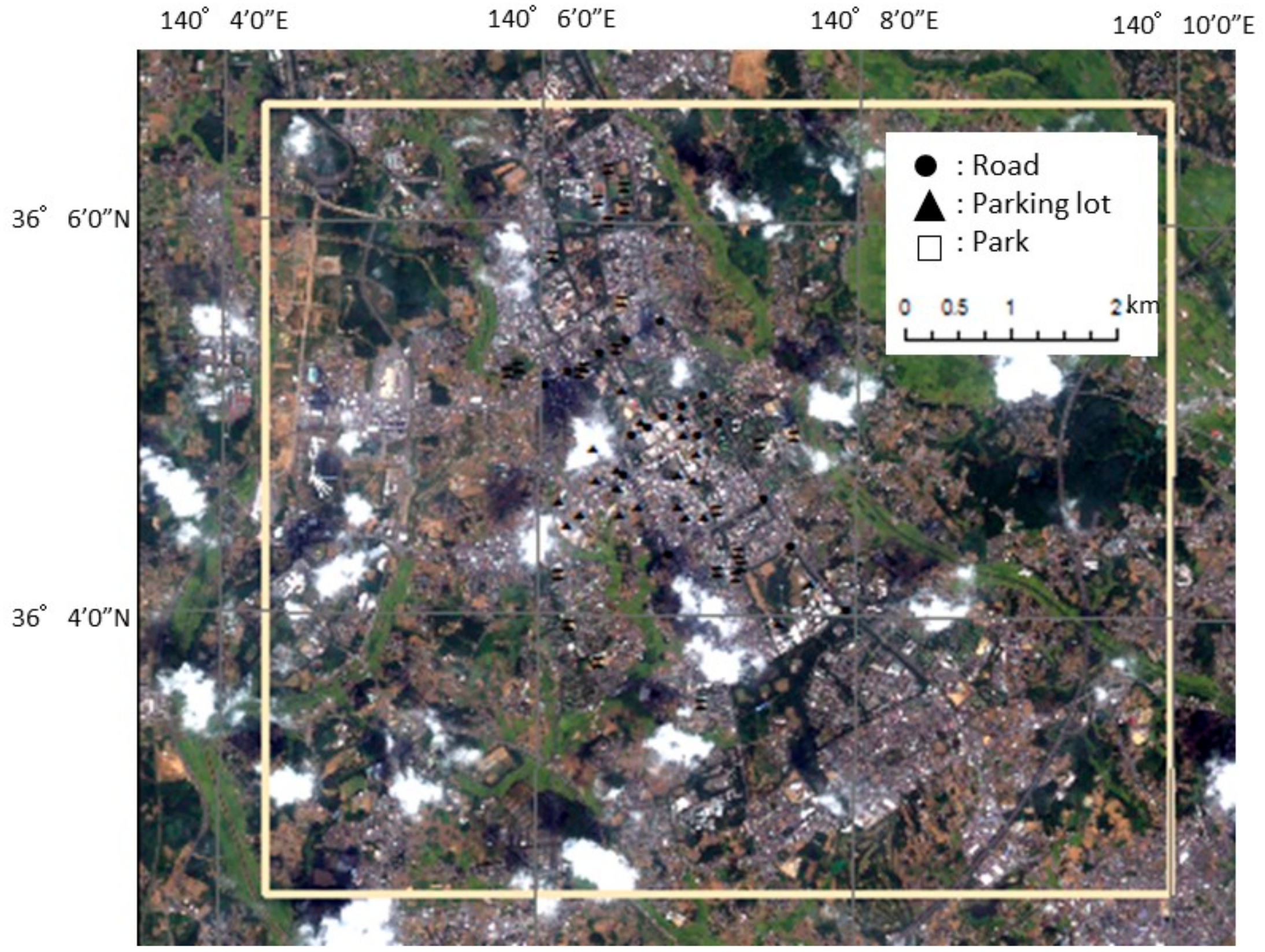
2.2. Study Site and Validation Points
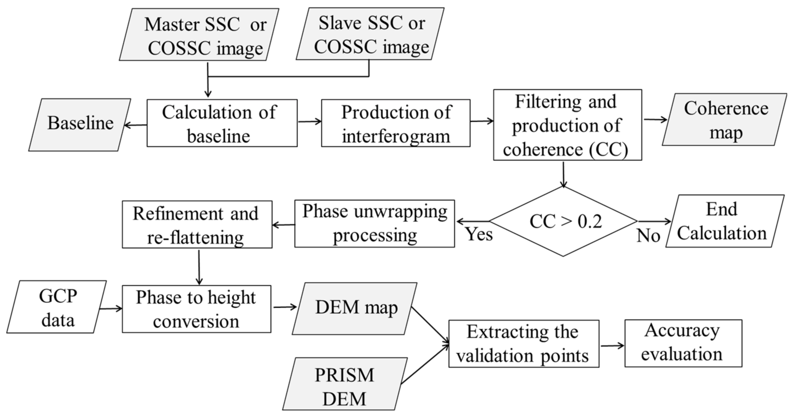
3. Method
4. Results
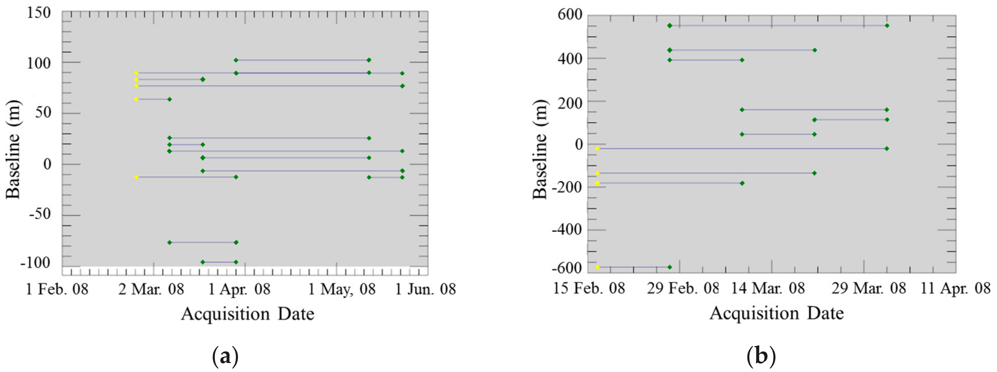
4.1. Baseline of Image Pairs
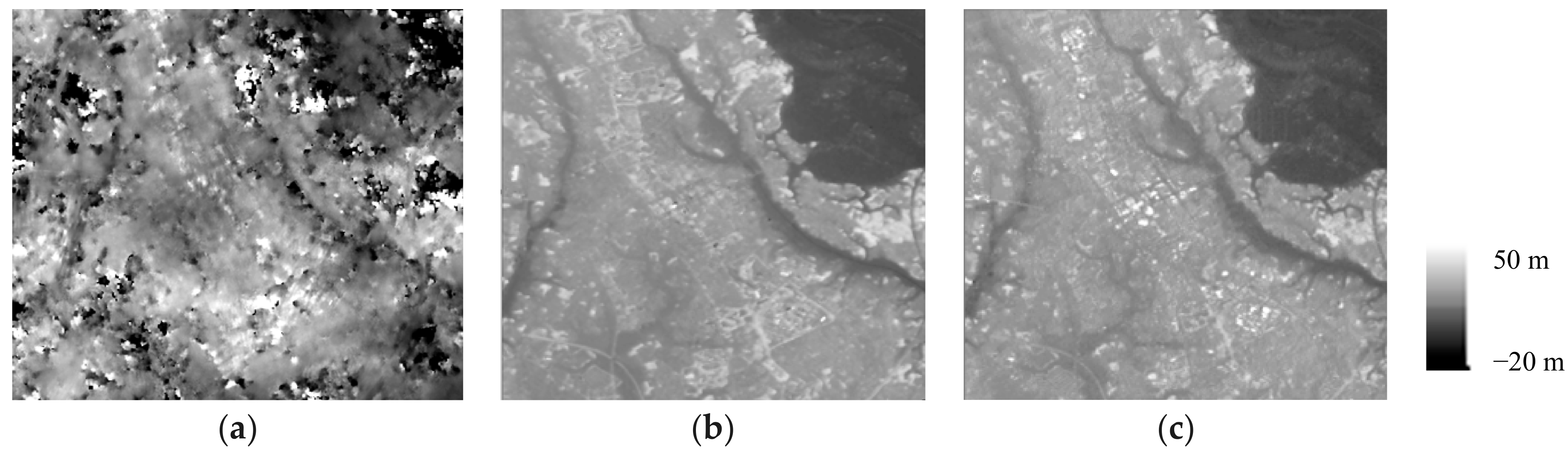
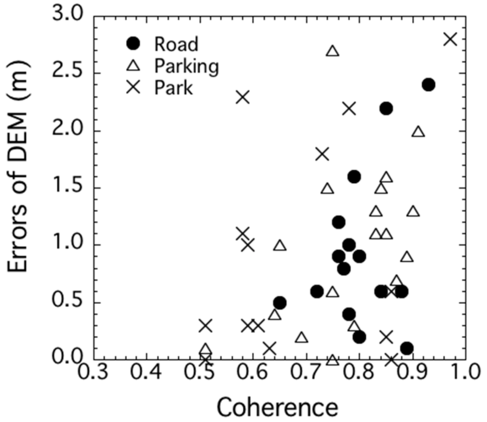
4.2. DEM Errors
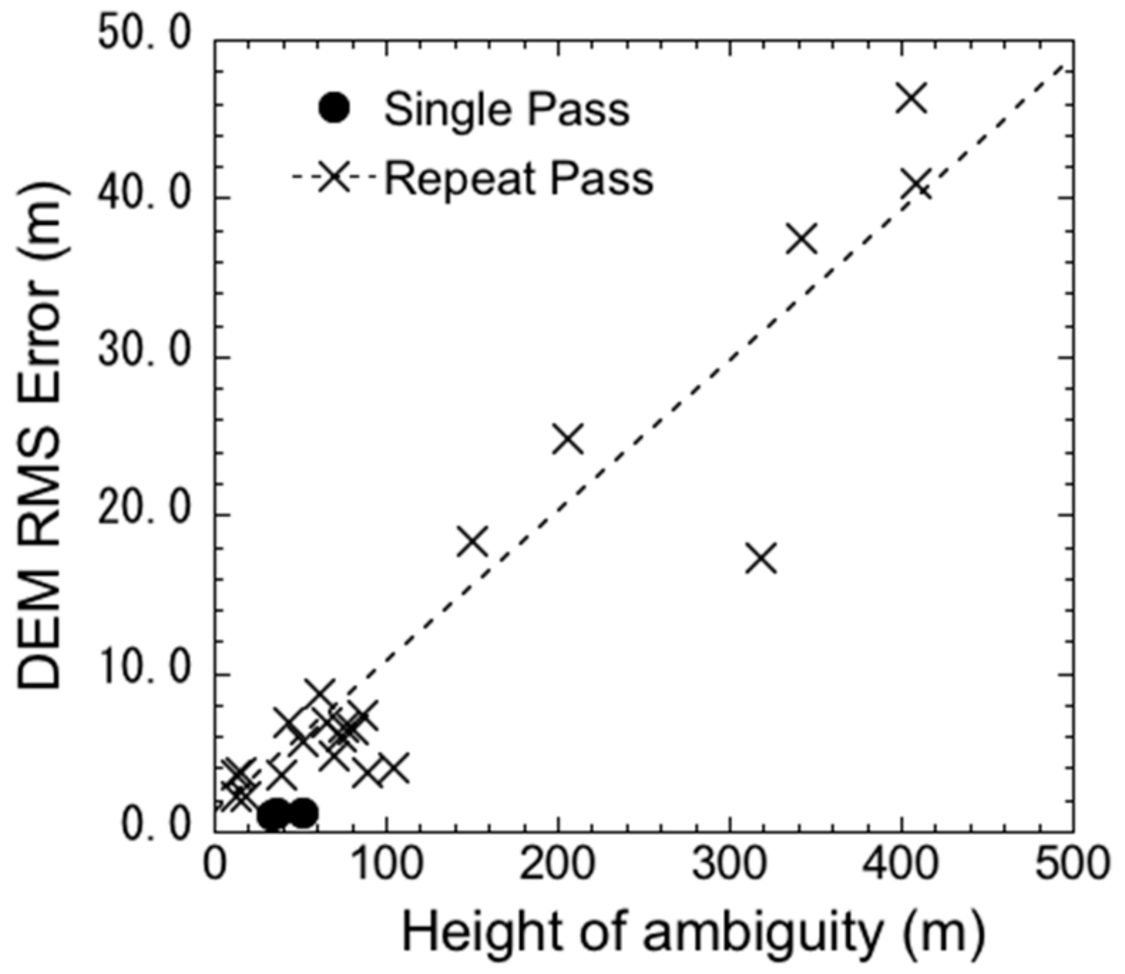
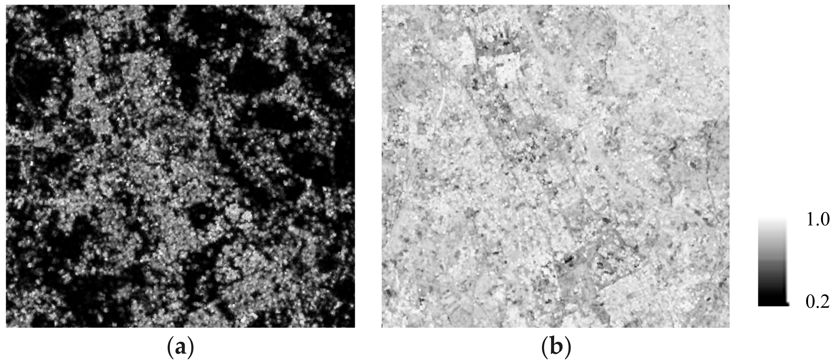
4.3. Interferometric Noise
4.4. Discussion
5. Conclusions
Author Contributions
Funding
Acknowledgments
Conflicts of Interest
References
- Werninghaus, R.; Buckreuss, S. The TerraSAR-X mission and system design. IEEE Trans. Geosci. Remote Sens. 2010, 48, 606–617. [Google Scholar] [CrossRef]
- Covello, F.; Battazza, F.; Coletta, A.; Lopinto, E.; Fiorentino, C.; Pietranera, L.; Valentini, G.; Zoffoli, S. COSMO-SkyMed an existing opportunity for observing the Earth. J. Geodyn. 2010, 49, 171–180. [Google Scholar] [CrossRef]
- Morena, L.; James, K.; Beck, J. An introduction to the Radarsat-2 mission. Can. J. Remote Sens. 2004, 30, 221–234. [Google Scholar] [CrossRef]
- Joyce, K.; Belliss, S.; Samsonov, S.; McNeill, S.; Glassey, P. A review of the status of satellite remote sensing and image processing techniques for mapping natural hazards and disasters. Prog. Phys. Geogr. Earth Environ. 2009, 33, 183207. [Google Scholar] [CrossRef]
- Giustarini, L.; Hostache, R.; Matgen, P.; Schumann, G.; Bates, P.; Mason, D. A Change detection approach to flood mapping in urban areas using TerraSAR-X. IEEE Trans. Geosci. Remote Sens. 2012, 51, 2417–2430. [Google Scholar] [CrossRef]
- Dong, L.; Shan, J. A comprehensive review of earthquake-induced building damage detection with remote sensing techniques. ISPRS J. Photogramm. Remote Sens. 2013, 84, 85–99. [Google Scholar] [CrossRef]
- Yague-Martinez, N.; Eineder, M.; Cong, M.; Minet, C. Ground displacement measurement by TerraSAR-X image correlation: The 2011 Tohoku-Oki Earthquake. IEEE Trans. Geosci. Remote Sens. 2012, 9, 539–543. [Google Scholar] [CrossRef]
- Liu, W.; Yamazaki, F.; Matsuoka, M.; Nonaka, T.; Sasagawa, T. Estimation of three-dimensional crustal movements in the 2011 Tohoku-oki, Japan earthquake from TerraSAR-X intensity images. Nat. Hazards Earth Syst. Sci. 2015, 15, 637–645. [Google Scholar] [CrossRef]
- Hansen, R. Radar Interferometry: Data Interpretation and Error Analysis; Springer: Dordrecht, The Netherlands, 2001; p. 308. ISBN 978-90-481-5696-2. [Google Scholar]
- Ferretti, A. Satellite InSAR Data—Reservoir Monitoring from Space; EAGE Publications: Houten, The Netherlands, 2014; p. 159. ISBN 978-90-73834-71-2. [Google Scholar]
- Nonaka, T.; Asaka, T.; Iwashita, K. The coherence characteristic analysis for high-resolution TerraSAR-X data -man-made objects and natural objects-. In Proceedings of the 42nd Scientific Assembly of the Committee on Space Research and Associated Events 2018, Pasadena, CA, USA, 14–22 July 2018. [Google Scholar]
- Nonaka, T.; Asaka, T.; Iwashita, K.; Liu, W.; Yamazaki, F.; Sasagawa, T. Quantitative analysis of relative geolocation accuracy of the TerraSAR-X enhanced ellipsoid corrected product. J. Appl. Remote Sens. 2017, 11, 4. [Google Scholar] [CrossRef]
- Nonaka, T.; Asaka, T.; Iwashita, K. Feature of DEM produced by Interferometric technique by ALOS PALSAR data. In Proceedings of the 60th (2016 Spring) Meeting of the Remote Sensing Society of Japan, Chiba, Japan, 12–13 May 2016. [Google Scholar]
- Nonaka, T.; Asaka, T.; Iwashita, K.; Ogushi, F. Feature of the coherence and accuracy of DEM generated by repeat pass InSAR processing of TerraSAR-X data. In Proceedings of the TerraSAR-X/TanDEM-X Science Meeting, Munich, German, 17–20 October 2016. [Google Scholar]
- Nonaka, T.; Asaka, T.; Iwashita, K.; Ogushi, F. Estimation of phase noise by time series analysis of ALOS-2 PALSAR-2 data. In Proceedings of the IGARSS2017 International Geoscience and Remote Sensing Symposium, Fortworth, TX, USA, 23–28 July 2017. [Google Scholar]
- Fritz, T.; Eineder, M. TerraSAR-X Ground Segment, Basic Product Specification Document, TX-GS-DD-3302, Issue 1.6, 31, 2009. Available online: http://www.dtic.mil/dtic/tr/fulltext/u2/a515513.pdf (accessed on 14 February 2018).
- Kahle, R.; D’Amico, S. The TerraSAR-X precise orbit control—Concept and flight results. In Proceedings of the International Symposium on Space Flight Dynamics, Laurel, MD, USA, 5–9 May 2014. [Google Scholar]
- Moreira, A.; Krieger, G.; Hajnsek, I.; Werner, M.; Hounam, D.; Riegger, S.; Settelmeyer, E. TanDEM-X: A TerraSAR-X Add-On Satellite for Single-Pass SAR Interferometry. In Proceedings of the IGARSS 2004 International Geoscience and Remote Sensing Symposium, Anchorage, AK, USA, 20–24 September 2004. [Google Scholar]
- Krieger, G.; Moreira, A.; Fiedler, H.; Hajnsek, I.; Werner, M.; Younis, M.; Zink, M. “TanDEM-X”: A satellite formation for high resolution SAR interferometry, IEEE Trans. Geosci. Remote Sens. 2007, 45, 3317–3341. [Google Scholar] [CrossRef]
- Zink, M.; Krieger, G.; Hauke, F.; Irena, H.; Moreira, A.; Werner, M. TanDEM-X—The first bistatic SAR formation in Space. In Proceedings of the Advanced RF Sensors for Earth Observation (ARSI), Noordwijk, The Netherlands, 5–6 December 2006. [Google Scholar]
- Shimada, M.; Tadono, T.; Rosenqvist, A. Advanced Land Observing Satellite (ALOS) and monitoring global environmental change. Proc. IEEE 2010, 98, 5. [Google Scholar] [CrossRef]
- Tadono, T.; Ishida, H.; Oda, F.; Naito, S.; Minakawa, K.; Iwamoto, H. Precise global DEM generation by ALOS PRISM. ISPRS Ann. Photogramm. Remote Sens. Spat. Inf. Sci. 2014, II-4, 71–76. [Google Scholar] [CrossRef]
- Nonaka, T.; Asaka, T.; Iwashita, K. Analysis of interferogram phase noise by bi-static data sets of TerraSAR-X. In Proceedings of the PIERS 2018, Toyama, Japan, 1–4 August 2018. [Google Scholar]
- Ulaby, F.; Long, D. Microwave Radar and Radiometric Remote Sensing; University of Michigan Press: Ann Arbor, MI, USA, 2013; p. 1116. ISBN 978-0472119356. [Google Scholar]
- Zebker, H.; Werner, C.; Rosen, P.; Hensley, S. Accuracy of topographic maps derived from ERS-1 interferometric radar. IEEE Trans. Geosci. Remote Sens. 1994, 32, 823–836. [Google Scholar] [CrossRef]
- Massonnet, D.; Rossi, M.; Carmona, C.; Adragna, F.; Peltzer, G.; Feigl, K.; Rabaute, T. The displacement field of the Landers earthquake mapped by radar interferometry. Nature 1993, 364, 138–142. [Google Scholar] [CrossRef]
- Fritz, T.; Brautigam, B.; Krieger, G.; Zink, M. TanDEM-X Ground Segment TanDEM-X Experimental Product Description, TD-GS-PS-3028, Issue 1.2, 2012. Available online: https://tandemx-science.dlr.de/pdfs/TD-GS-PS-3028_TanDEM-X-Experimental-Product-Description_1.2.pdf (accessed on 14 February 2018).
- Goldstein, R.; Werner, C. Radar interferogram filtering for geophysical applications. Geophys. Res. Lett. 1998, 25, 4035–4038. [Google Scholar] [CrossRef]
- Costantini, M. A novel phase unwrapping method based on network programming. IEEE Trans. Geosci. Remote Sens. 1998, 36, 813–821. [Google Scholar] [CrossRef]
- Goblirsch, W.; Pasquali, P. Algorithms for calculation of digital surface models from the unwrapped interferometric phase. In Proceedings of the IGARSS1996 International Geoscience and Remote Sensing Symposium, Boston, MA, USA, 27–31 May 1996. [Google Scholar]
- Yoon, Y.; Eineder, M.; Yague-Martinez, N.; Montenbruck, O. TerraSAR-X precise trajectory estimation and quality assessment. IEEE Trans. Geosci. Remote Sens. 2009, 47, 1859–1868. [Google Scholar] [CrossRef]
- Takemoto, S.; Inoue, H.; Nonaka, T.; Iwashita, K. Feature analysis of high-resolution TanDEM-X DEM product -Case study for Tsukuba city, Ibaraki prefecture-. In Proceedings of the 64th (2018 Spring) Meeting of the Remote Sensing Society of Japan, Chiba, Japan, 17–18 May 2018. [Google Scholar]
- Nonaka, T.; Asaka, T.; Iwashita, K. Errors analysis of DEMs by interferometric synthetic aperture radar utilizing several acquisition conditions of the multi-frequency SAR data. J. Jpn. Soc. Civ. Eng. 2018. in print. [Google Scholar]


| Orbit type | Sun-synchronous repeat orbit |
| Satellite altitude | 505–533 km |
| Repeat period | 11 d |
| Repeat cycle | 167 orbits in one repetition |
| Local time of ascending node | 1800 ± 0.25 h |
| Mode | StripMap | High-Res. SpotLight | Bistatic |
|---|---|---|---|
| Satellite | TerraSAR-X | TerraSAR-X | TerraSAR-X and TanDEM-X |
| Acquisition date | 2008: 26 February, 8 March19 March, 30 March13 May, 24 May | 2008: 16 February, 27 February9 March, 20 March31 March | 2011: 6 September2012: 3 September, 6 October |
| Resolution (az, rg) | 3.3 m, 2.7 m | 1.1 m, 1.8 m | 3.3 m, 2.6 m |
| Polarization | VV | VV | HH |
| Incidence angle | 41.4° | 42.1° | 43.2° |
| Direction | Descending | Ascending | Ascending |
| Repeat-Pass Interferometry | Single-Pass Interferometry | |
|---|---|---|
| Average | 0.41 | 0.82 |
| Standard deviation | 0.18 | 0.09 |
| 1st quartile | 0.25 | 0.77 |
| 2nd quartile | 0.36 | 0.84 |
| 3rd quartile | 0.54 | 0.88 |
| Repeat-Pass Interferometry | Single-Pass Interferometry | |
|---|---|---|
| Road Parking lots Park | 0.57 ± 0.13 0.47 ± 0.16 0.43 ± 0.15 | 0.80 ± 0.07 0.78 ± 0.11 0.69 ± 0.15 |
| All fixed points | 0.49 ± 0.16 | 0.76 ± 0.13 |
© 2018 by the authors. Licensee MDPI, Basel, Switzerland. This article is an open access article distributed under the terms and conditions of the Creative Commons Attribution (CC BY) license (http://creativecommons.org/licenses/by/4.0/).
Share and Cite
Nonaka, T.; Asaka, T.; Iwashita, K. Evaluation of Atmospheric Effects on Interferograms Using DEM Errors of Fixed Ground Points. Sensors 2018, 18, 2336. https://doi.org/10.3390/s18072336
Nonaka T, Asaka T, Iwashita K. Evaluation of Atmospheric Effects on Interferograms Using DEM Errors of Fixed Ground Points. Sensors. 2018; 18(7):2336. https://doi.org/10.3390/s18072336
Chicago/Turabian StyleNonaka, Takashi, Tomohito Asaka, and Keishi Iwashita. 2018. "Evaluation of Atmospheric Effects on Interferograms Using DEM Errors of Fixed Ground Points" Sensors 18, no. 7: 2336. https://doi.org/10.3390/s18072336
APA StyleNonaka, T., Asaka, T., & Iwashita, K. (2018). Evaluation of Atmospheric Effects on Interferograms Using DEM Errors of Fixed Ground Points. Sensors, 18(7), 2336. https://doi.org/10.3390/s18072336