Article

Dispersal Ecology of Golden Eagles (Aquila chrysaetos) in Northern Greece: Onset, Ranging, Temporary and Territorial Settlement

by
Lavrentis Sidiropoulos
1,*,
D. Philip Whitfield
2,
Konstantinos Poirazidis
3,
Elisabeth Navarrete
4,
Dimitris P. Vasilakis
5,
Anastasios Bounas
6,
Elzbieta Kret
7 and
Vassiliki Kati
1
1
Biodiversity Conservation Laboratory, Department of Biological Applications and Technology, University of Ioannina, 45110 Ioannina, Greece
2
Natural Research, Brathens Business Park, Hill of Brathens, Banchory, Aberdeenshire AB31 4BY, UK
3
Department of Environment, Ionian University, M. Minotou-Giannopoulou Str., Panagoula, 29100 Zakynthos, Greece
4
Hellenic Ornithological Society—BirdLife Greece, Ag. Konstantinou 52, 10437 Athens, Greece
5
Didymoteicho Forestry Service, 58400 Didymoteicho, Greece
6
Molecular Ecology and Conservation Genetics Laboratory, Department of Biological Applications and Technology, University of Ioannina, Ioannina University Campus, 45110 Ioannina, Greece
7
Society for the Protection of Biodiversity in Thrace, 68400 Soufli, Greece
*
Author to whom correspondence should be addressed.
Diversity 2024, 16(9), 580; https://doi.org/10.3390/d16090580
Submission received: 8 August 2024 / Revised: 28 August 2024 / Accepted: 3 September 2024 / Published: 13 September 2024
(This article belongs to the Special Issue Conservation and Ecology of Raptors—2nd Edition)

Abstract

:
Natal dispersal is a crucial period for raptors with serious implications for individuals’ survival and population demography. In this study we analyzed data from 18 GPS-tracked golden eagles in order to describe their dispersal ecology in northern Greece, where the species feeds mostly on tortoises. Young eagles in our population dispersed at 176 days post fledging, spent their first year of independence relatively close (40–60 kms) to their natal ranges and exhibited a variable temporary settlement behavior. Overall dispersal range sizes did not differ seasonally, but temporary settlement area range sizes were significantly larger in winter. Three eagles survived to territorial settlement and occupied ranges 20–60 kms from their natal areas. The application and refinement of the Scottish GET dispersal ranging model suggested that eagles used areas that had higher topographical relief and lower canopy cover during their natal dispersal. Habitat heterogeneity seems to also be influential during temporary settlement. Our study is the first to provide both such insights for golden eagles in southern eastern Europe and a method for delineating temporary settlement areas for the species. Our findings can be explained in terms of food and habitat availability. We highlight the importance of conserving heterogeneous open areas of complex topography and applying proactive management measures within temporary settlement areas for our population’s conservation.

1. Introduction

Dispersal in raptors, as in every other organism, has serious implications for population dynamics and persistence, gene flow, distribution maintenance and expansion [1,2]. Raptor dispersal encompasses three distinct phases [3,4,5]: (a) the departure from the natal site and relinquishing parental dependence (onset of dispersal), (b) a prospecting, transient phase of the natal dispersal period (hereafter NDP) and finally (c) the territorial settlement and subsequent breeding that for large raptors like the golden eagle (Aquila chrysaetos) is for many years if not for life [6].
Several aspects of raptor dispersal are poorly understood [7,8], although satellite telemetry is gradually building an information base that was previously inaccessible [9,10]. While the golden eagle is widely studied globally [6,11], there are areas of its distribution where relevant detailed investigations are still lacking and it is only recently that satellite telemetry has started providing relevant insights [11,12].
Determining the dispersal onset has been recently typified through standardized, straightforward methods [13,14] that can identify the moment of dispersal, a decision of potentially serious consequences for individual survival during the first months after the post-fledging dependence period (PFDP). The NDP that follows is characterized by further trade-offs of short-term survival and information gathering when eagles need to balance the need for successful foraging that is enhanced in familiar environments with the need to explore new habitats [5]. Exploration provides both clues into suitable habitat for further dispersal and prospecting for recruitment into the territorial, breeding segment of populations [15,16].
Although the most critical demographic component of large eagle populations in terms of conservation value is the adult, territorial segment, survival to breeding age, especially regarding subadult individuals, is also crucial for population persistence [17,18]. The NDP is when survival probabilities are generally at their lowest for large raptors [19,20]. While a large part of breeding populations are generally well conserved, young individuals might range in lower-quality habitats and face threats outside protected areas [21], and dispersing raptors might also use different habitats and shift habitat preferences after natal dispersal [22]. Alternatively, they might be attracted to vacant territories where eagles are routinely killed [23].
Moreover, during their NDP individuals of certain species tend to occupy, repeatedly and for prolonged periods of time, areas that feature high food availability but otherwise limited or nonexistent breeding opportunities. These areas are known as “temporary settlement areas” (TSAs) and this behavior is known to occur in several large eagles [24,25,26,27,28,29]. The occurrence of particular threats such as persecution and dangerous infrastructure in these areas might incur high mortality in the immature and floater segment of populations and therefore seriously impact demography [25,26,30,31,32]. Understanding aspects of dispersal behavior in space and time, therefore, is of utmost importance for conservation of threatened populations [25,26,33,34].
Golden eagles are large soaring raptors and are thus dependent largely on thermal and orographic uplift associated with topography, during everyday ranging activities, dispersal and migration [35,36,37,38,39]. At the same time, dense canopy cover seems to negatively affect golden eagle productivity and ranging by precluding the eagles’ access to prey [40,41,42]. It would therefore be expected that golden eagles in Mediterranean landscapes would also utilize open areas of complex topography during dispersal.
The aims of this study are to describe the dispersal behavior of young golden eagles in northern Greece by: (a) determining the onset of the NDP, (b) determining the distancing from the natal territory in the first ten months of independence and the overall ranging area during the NDP, (c) describing the incidence of temporary settlement behavior during the NDP (prevalence, area and duration), (d) determining the territorial settlement and natal dispersal distance for surviving birds and (e) identifying habitat preferences during the entirety of dispersal period and temporary settlement. We finally discuss our findings from a conservation perspective.

2. Materials and Methods

2.1. Study Area and Species

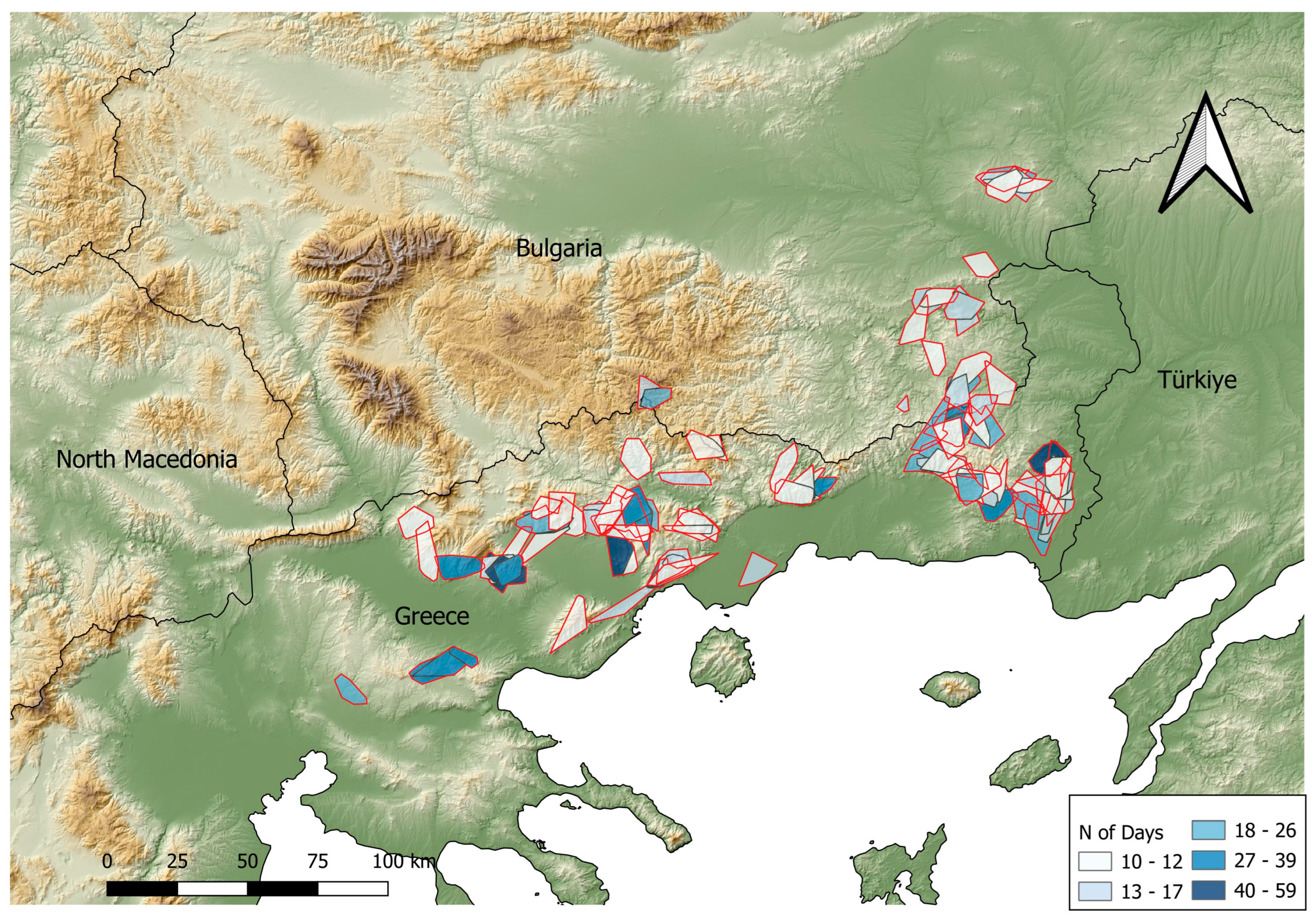
Our study area encompassed the Eastern Macedonia and Thrace administrative divisions in northern Greece (14,157 km2) and extended through eagle dispersal movements to the adjacent regions in northern Greece and Bulgaria (Figure 1 and Figure 5). The area is characterized by a Mediterranean/continental Mediterranean climate, and altitudes range from 0 to >2000 m above sea level. The main land cover types include mosaics of openings and broadleaf and conifer woodlands in intermediate altitudes, Mediterranean sclerophyllous vegetation in southern, more coastal areas and crop cultivations in lowland, flat areas. Areas > 1500 m asl are dominated by alpine and subalpine pasture. The main land management in natural and seminatural areas is forestry and grazing.
The golden eagle is endangered (EN) in Greece with an estimated population of 105–155 pairs and declining in the northern mainland [43]. Its main prey during the breeding period are Testudinidae tortoises and the diet expands during the winter months to a greater variety of taxa [44]. Forty-four eagle territories are known in our study area (2008–2023) with at least 40% believed to be currently vacant [45]. The productivity in our study area was 0.5–0.55 fledglings per territorial pair per year and mean nearest neighbor distance between nest sites 8.47 km [46].

2.2. Satellite Tagging, Data Collection and Determination of Dispersal Onset

Over a nine-year period (2015–2023), we tagged 19 pre-fledged golden eagles in the nest (ages of 50–70 days) [9] and 1 fledged juvenile (age of c.a. 250 days) caught in a bownet trap [47]. We fitted 13 tags as backpacks with an X-type Teflon ribbon and 7 as pelvic harnesses [48] (Appendix A Table A1). We molecularly sexed 13 chicks using blood or feather samples based on the presence of CHD1-Z and W fragments [49]. We morphometrically sexed all chicks as males when weighing < 3.5 kg and having a hallux length less than 45 mm and as females otherwise, while the trapped juvenile was considered as male (weight = 3.8 kg). Molecular sexing confirmed morphometric predictions and one individual without a genetic sample was confirmed post mortem (Table A1). Two tags (Ecotone models) were set at irregular intervals and only used in dispersal onset analysis. The rest, 18 tags (Ornitela and Eobs models), were set at five-minute intervals or less on full battery. Daily onset and closure of high-resolution telemetry depended on the fluctuating subsequent battery levels but, in any case, started at the latest within 90 min after sunrise and ended at the earliest within 45 min before sunset for 95% of tracking days. Ornitela transmitters have the option of adjusting the GPS fix rate at night, so it was possible to derive a few night locations for roost detection. Their GPS error has been estimated as <20 m [50]. There was no evidence of transmitter effects on behavior and no recovered birds displayed signs like abrasions on harness contact points (shoulders, keel or abductors) and necropsied birds (deaths most likely due to anthropogenic causes, [45]) were in otherwise good condition. All handling was undertaken under the appropriate yearly licenses from the General Directorate of Forests and Forest Environment, Department of Forest Management of the Ministry of Environment and Energy. All data were collected in the Movebank animal movement data depository [51] (Movebank study ID 601374863).
Two of the tagged eagles died during the PFDP and were excluded from any analysis. Data collection ended on 15 March 2024 for all individuals, apart from a female eaglet tagged in 2023, that had not dispersed. It was reassessed on the 29 March, whereupon it was found dispersed.
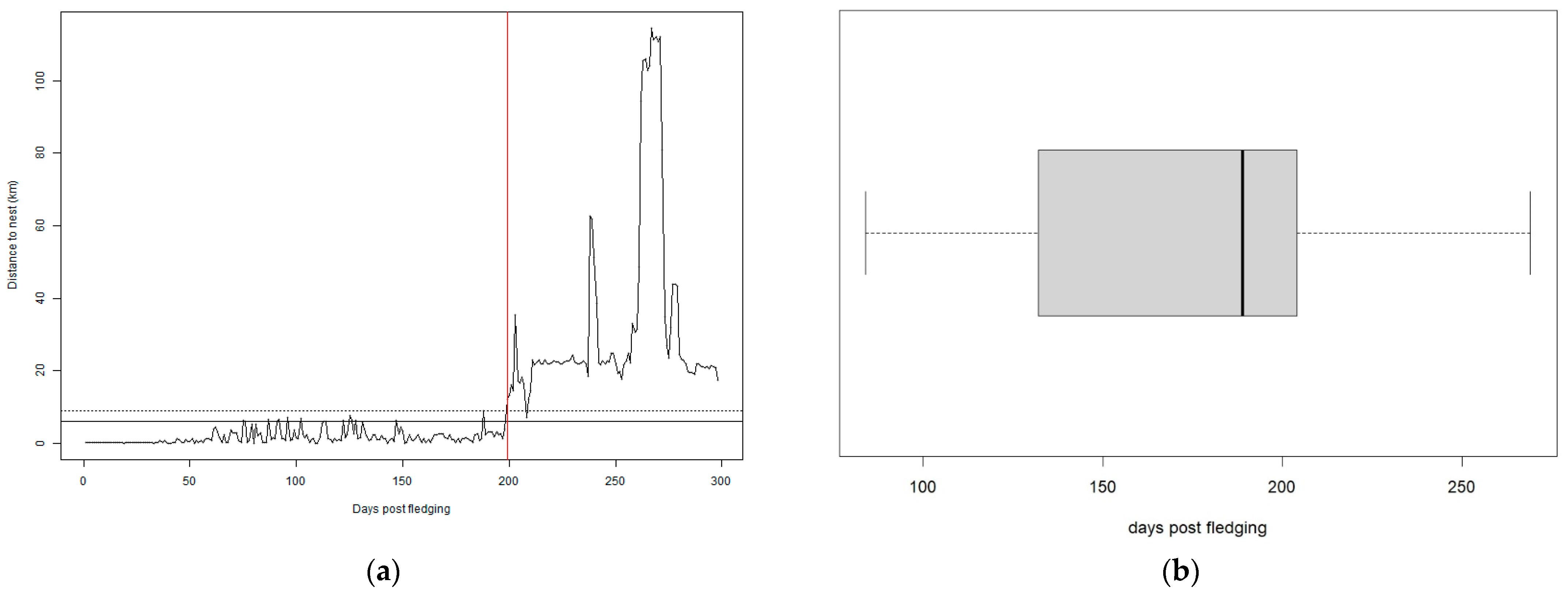
We visually inspected GPS fixes and determined fledging date as the first day locations were consistently clustered away from the nest (we attributed the 13 July as the fledging date of the trapped bird, which was the mean date for the population). We then determined dispersal onset, using one fix daily (the one closest to noon), as the time when chicks distanced themselves for the first time at least 9 km from the natal nest and did not venture closer than 6 km for at least 10 days, after method 7 of [14] (Figure 2a). These numbers have been set to determine a spatiotemporal threshold beyond which the young eagles should be able to sustain themselves for a long period of time (10 days) without starving and returning for parental provision of food. We defined the start of the dispersal period at the day of the dispersal onset, excluding the PFDP data.
The end of the dispersal period for our analyses was either the data collection cut-off date of 15 March 2024 (n = 4 eagles of 2nd–3rd cy), date of signal loss with unknown fate (n = 4 eagles), the date of settlement in a breeding territory for surviving birds (n = 3 eagles, see Section 2.5) or date of death during dispersal (n = 7 eagles). We calculated the median coordinates of subsequent roosts post dispersal onset and extracted their distance to natal nests as a metric of movement from the parental territory for the first 311 days post dispersal (period completed by at least ten surviving eagles).

2.3. Dispersal Area Use

We divided the tracking periods into winter (15 November to 15 March) and summer periods (16 March to 14 November) to match the main golden eagle prey (Testudinidae tortoises) activity periods [44]. We calculated utilization distributions (UDs) using a movement-based Kernel estimate (MKDE) [52], implemented in the R package AdehabitatHR [53,54]. UDs were calculated on 200 m predefined grids, using only high-resolution data (max interval 20 min, with the majority of data used being five minutes apart accounting for 80% of total daily hours of the tracking period), estimating interpolated locations every 2.5 min and a minimum smoothing parameter of 100 m when birds were stationary.

2.4. Temporary Settlement Areas

To identify the period of temporary settlement (TS) behavior events, we developed a threshold-based algorithm, given that the time of TS must be continuous and substantial and the area relatively restricted [28,29]. The algorithm was run on a subset of the high-resolution (5 min interval) dataset, subsampled to at least 1 h intervals to achieve independence and ease computation time. We considered three parameters in our algorithm: (a) we selected a ten-day forward moving window, corresponding to the minimum tracking period examined [29,55,56]. (b) We considered as a threshold area a standard area of 6 km radius (113.1 km2), determined to be a good approximation of a territorial eagle’s ranging behavior unconstrained by neighbors [14,38]. (c) We considered a 95% level to delineate the minimum convex polygon (MCP) to exclude potential excursions from the settlement area. Therefore, when the 95% MCP did not exceed 113.1 km2 for ten continuous days, it was determined that the eagle was temporarily settled. This behavior was considered as a temporary settlement event with a duration starting from the first day of the moving window and ending at the 10th day or later, as long as the criteria were met. When the bird’s ranging area exceeded the area threshold, the event was interrupted, and a new event might commence when the criteria were again met. While the MCP is an easily computed and conservative estimate of temporary settlement behaviour, this method is not informative in regard to intensity of use and may encompass a wide, unused area [57]. To obtain more detailed information on eagle use of the TSAs, we therefore calculated for temporary settlement events, MKDE utilization distributions and core areas as in Section 2.2, using the same parameters, bar the grid size that was set at 50 m.
We report on the number of temporary settlement events per birds, the proportion of total tracking time in which the young golden eagles performed temporary settlement and the rate of temporary settlement as n events per month of tracking (n total NDP tracking days divided by 30).

2.5. Territorial Settlement

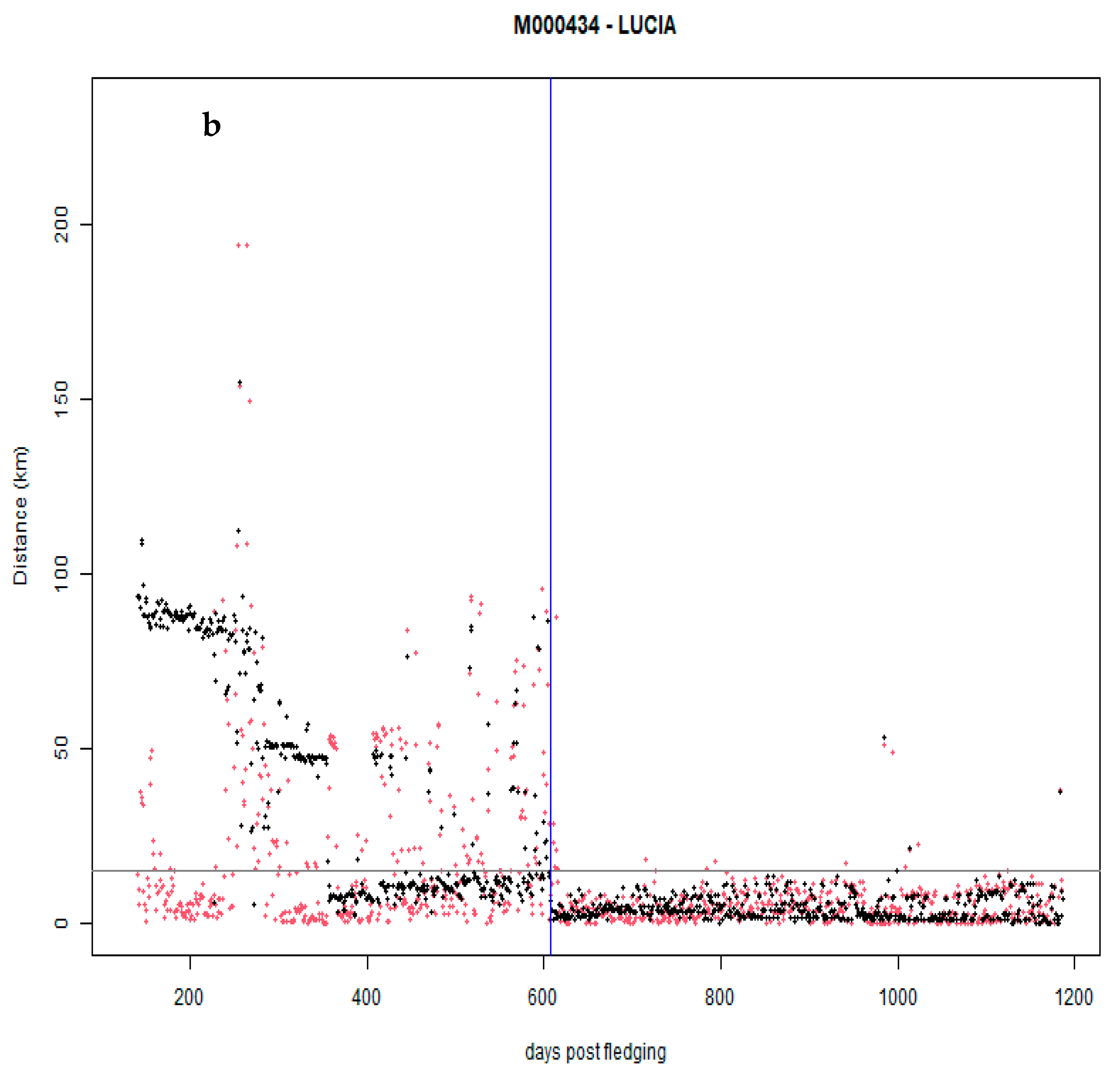
Using the track dataset of the 12 birds for which data were available at 250+ days post fledging, we determined territorial settlement. Territorial settlement implies that settled bird movements are restricted overall and centered around a particular location, and settled birds will not abandon this location, performing excursions for long periods of time [56], Appendix A, Figure A1). We first selected the nocturnal locations, using the R package suncalc [58], and we calculated their median coordinates value per night, corresponding to each night’s roost. The median coordinates of the last 20 tracking night roosts of each eagle dataset implied the potential territory center [56].
We then developed a two-step settlement algorithm, following [56]: first, we identified the first potential instance of eagle settlement 250 days post fledging, when for at least 30 consecutive nights, the night roost distance between each night and 10 nights earlier was less than 10 km and when the eagle stayed within a 15 km radius from its implied territory center. The second step included a check to ensure this did not concern a particularly long temporary settlement event: if the bird has not roosted outside this area for a period of seven continuous days thereafter, it is considered settled (Appendix A Figure A1). We confirmed established territories by visiting the territorial settlement areas and confirming territorial, breeding behavior such as observations of paired birds, nest building or refurbished nest sites in areas of clumped fixes [59].

2.6. Habitat Analysis

We performed habitat preference analyses within the temporary settlement areas and applied and refined a habitat suitability model for dispersing golden eagles [37]. We compiled a multilayered habitat characteristics dataset. We used the Corine Land Cover (CLC) vector dataset [60] to derive our vegetation layers, the European Digital Elevation Model (DEM) [61] and various datasets to compile anthropogenic variables compatible for Bulgaria and Greece (Table A2). For topographic variables we calculated altitude, slope and aspect and further utilized the ridge selection algorithm of [37]. All layers were vectorized or resampled on the 25 m raster cell DEM grid.
We rasterized the CLC vector and reclassified it to reduce the number of parameters in three main categories: extensive agriculture (CLC 3rd level codes 211, 241–244), wood and scrub (311–313, 323) and open areas (231, 321, 322, 324, 331–335). We added a further land cover variable, canopy cover, resampling by bilinear interpolation the 10 m resolution European-wide tree cover density dataset [62]. Apart from using it as a continuous variable, we reclassified it as open and closed vegetation with a split at 50% cover density. We then used the landscape metrics R library [63] to compute the division index [64]. The division index was multiplied by 100 to obtain meaningful estimates in models, with 0 indicating homogeneous landscapes and 100 the maximum possible landscape heterogeneity (Table A2).

2.6.1. Habitat Suitability for Dispersing Golden Eagles

For habitat suitability during the overall dispersal period we implemented the Golden Eagle Topographic (GET) model [37]. As in the original model we used topographic variables (distance to ridge, slope, altitude and aspect as northness and eastness). The GET model has been shown to be a simple and effective way to define areas of high suitability for dispersing golden eagles. It assigns spatial raster cells into habitat preference classes (1–10, 10 being the highest preference score) by summing preference indices for each variable. Variable preference indices (PIs) are derived from Manly’s Selection index (ratio of proportion use in class to proportion availability in the landscape across variable classes). Use was derived by extracting cell values of the GPS fixes and the availability was the proportion of each class across the landscape.
We set as availability landscape the parts of the full MKDE ranging polygons, dissolved across birds, intersecting with Bulgaria and Greece (95% of 30,664 km2). We filtered the diurnal nomadic dispersal period GPS fixes, subsampled to at least one hour to achieve independence [12,65] to extract use (Appendix A). We split distance to ridge into 33 25 m classes (0–25 to 775–800 and pooled distances > 800 m), slope into 10 five-degree classes (0–5 to 45–50 and pooled slopes > 50 degrees) and altitude into 31 50 m classes (0–50 to 1450–1500 and pooled altitudes > 1500 m). Aspect was not found to be influential either as northness or eastness (various classification schemes of both variables indicated no preference or avoidance, with index confidence intervals overlapping one) and was excluded from the model.
We split our dataset into training and testing subsets (75 and 25%, respectively), calculated PIs and assigned class values (further details in Appendix B.1). The resulting raster (summed values ranging from 14.4 to 474.6) was split into deciles and cells were assigned to the final preference class (1–10). This reclassified raster was the final topographic model.
While the GET model was designed as a topographic model, and thus a highly generalized one, with wide applicability across the golden eagle distribution, we were also interested in a subtle refinement, more consistent with eagle habitats in our study area. Unlike Scotland, where the GET model was developed and where main forest cover is commercial forestry, wooded habitats is SE Europe display a complexity in woody vegetation composition and configurations [66,67], with several types of forest and scrub covers and their mixtures. To include this without compromising the simplicity of the model, we used the tree cover density as a single variable, without including different woody vegetation cover types. We produced a 500 m moving window average of the European Tree Cover Density dataset on a 25 m grid, as a golden eagle’s specific location might not necessarily reflect its relevant habitat preference, given its wide sensory perception abilities and its hunting behavior, prospecting large areas both during perch hunting and flight [6,44]. We split this dataset into 17 5% increment classes, pooling covers of ≥80% together. We implemented this model on the upper half of the GET model preference classes only, in order to avoid confounding effects of lowland open areas (Appendix B.1). This model is hereafter termed the GETc model.

2.6.2. Temporary Settlement Area Selection and Use

We extracted the 95% isopleths of TSA UDs, calculated the TSA range core area level following [68] and extracted the respective isopleth contour. We assigned season to each event (for events overlapping the period change dates we assigned the season in which most days belonged). We merged polygons of the same bird in the same season at each level (MCP, 95% MKDE and core area MKDE isopleths) after visual inspection of overlap in QGIS [69] to avoid pseudo-replication, resulting at 64 sets of matched MCP, 95% and core area isopleth polygons.
At an exploratory level, we contrasted the habitat variables at the MCP, 95% and core area levels to describe habitat preference, expecting eagles will display higher preference for habitat characteristics at the core area level, followed by the 95% isopleth in relation to the MCP. For each variable we performed Friedman’s tests and subsequent pairwise Wilcoxon tests and visualized matched data boxplots (Appendix A, Table A2).
We used the package survival [70] to contrast core area and 95% MKDE levels as a use/availability design by means of conditional logistic regression [71]. We modeled the preference as a binomial distribution, assigning 0 to the 95% MKDE isopleth polygon and 1 to the core area level, with the individual temporary settlement area as a grouping variable, to match site use with availability [72]. We performed a stepwise model fitting procedure (Appendix B.2). After fitting models where season was dubiously selected as a variable in an interaction (Table A3 and Table A4), we again merged overlapping seasonal polygons to 53 sets (Figure 5) and repeated the procedure.
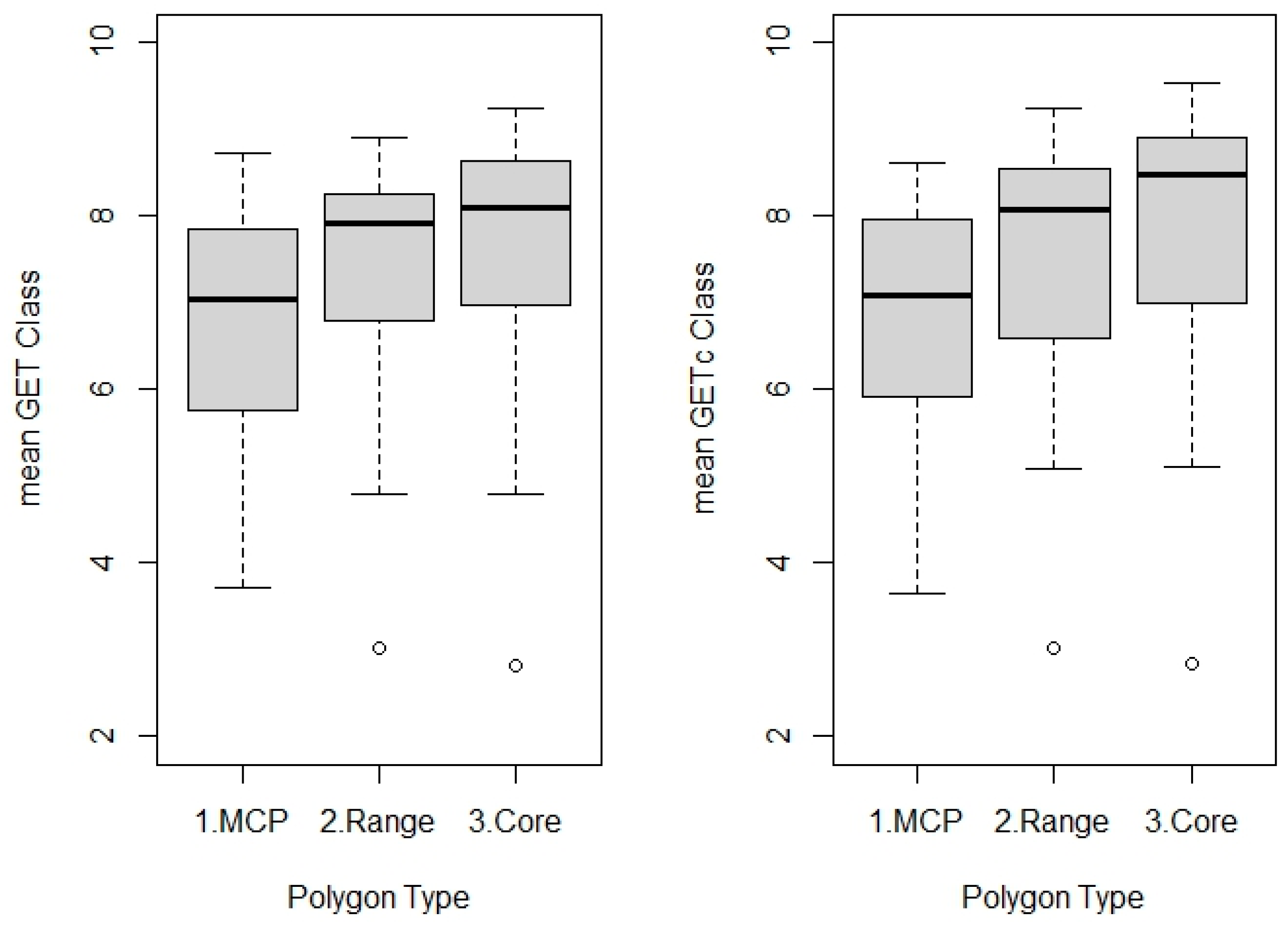
We finally extracted the GET model scores for each class to assess its performance within the TSAs, expecting progressively higher values between MCPs, 95% isopleths and core areas.

3. Results

We collected a total of 1,361,236 locations from 20 juvenile golden eagles, the largest dataset for the species in SE Europe. Fourteen of our tagged eagles were sexed as males and six as females, combining morphometric and molecular techniques (Appendix A Table A1).

3.1. Dispersal Onset

Dispersal onset ranged from 84 to 269 days post fledging for the 18 golden eagles studied (mean = 176 ± 48.1 SD, median = 189 days post fledging) (Figure 2). This corresponds to early–mid-January, with most eagles dispersing from late November to late February. Two individuals returned to their natal home ranges for prolonged periods of time (>10 days) after fulfilling the independence thresholds and even performed temporary settlements there. Prior to dispersing, four eagles performed no exploratory forays (excursions from the natal range prior to dispersal), thirteen performed at least one beyond 20 km and nine exceeded 50 km.

3.2. Distancing from the Natal Territory and Dispersal Area Ranging

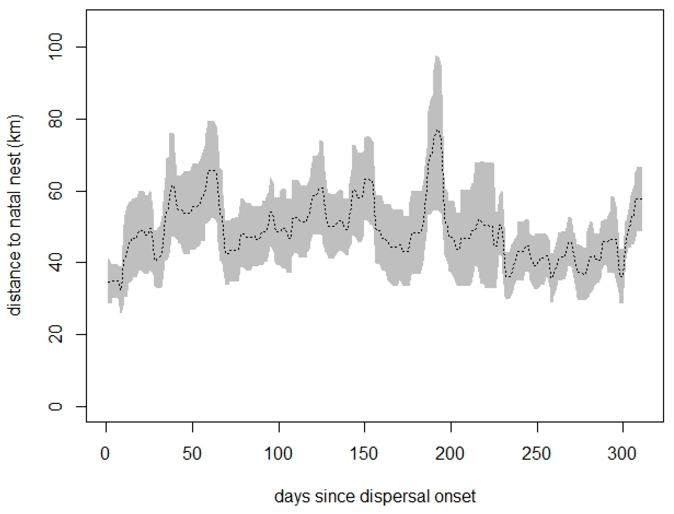
On average, eagles spent their first 311 days post dispersal at a distance between 40 and 60 km from the natal nest (mean 48.25 km ± 9.19 SD) (Figure 3). Dispersal area sizes varied between birds and winter polygon areas had greater variability (n = 14). Mean 95% MKDE polygons were 709.0 +/− 350.6 km2 and 876.6 +/− 711.1 km2 for summer and winter months, respectively. Considering the respective metrics for core areas (mean level for summer 75 +/− 2.1% and 73 +/− 1.8% for winter), these were 95.2 +/− 30.1 km2 and 101.8 +/− 69.3 km2. There were no correlations between number of tracking seasons and polygon size (Spearman correlations in each season p > 0.05) nor differences between polygon sizes between seasons per individual (Wilcoxon matched pairs tests p > 0.05).

3.3. Temporary Settlement Behavior

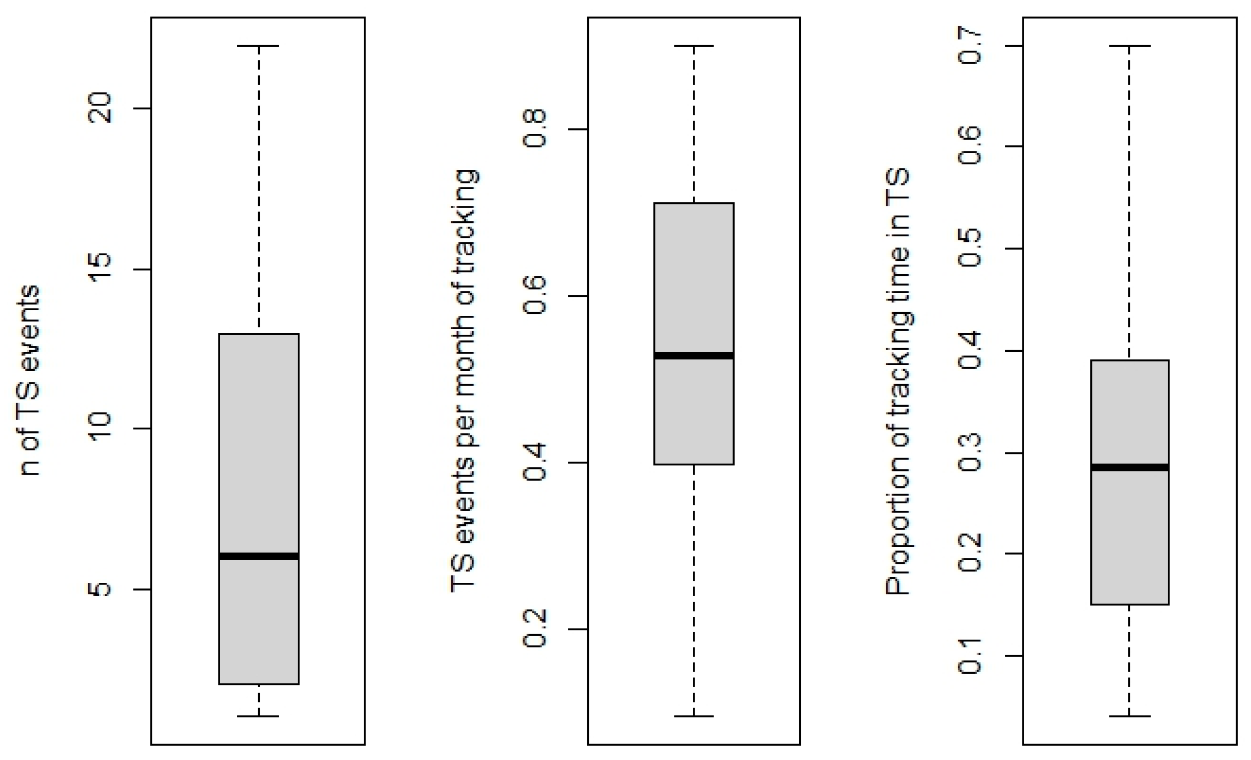
All birds performed at least one temporary settlement (TS) event (mean 8.4 ± 7.3, n = 14). The mean rate of events was 0.53 ± 0.25 events per month of tracking time, spanning a mean proportion of 0.28 ± 0.19 of their entire NDP (Figure 4 and Figure 5). The proportion of time spent in TSAs was not related to the length of the tracking period (Spearman’s correlation coefficient p > 0.05).
More TS events were identified in the summer (n = 79) than in the winter period (n = 38), but this difference was not significant when considering the total tracking days completed in each season (proportion test χ2 = 1.18, df = 1, p = 0.28). Mean core area contour levels were similar for winter (71.30% ± 2.46) and summer (71.34% ± 2.07). Core area sizes did not differ seasonally, but the 95% range was greater in winter (Wilcoxon test W = 1052, p ≤ 0.02) (Table 1).

3.4. Territorial Settlement

Of the twelve eagles with consistent data (tracking extending more than 250 days post fledging), eight showed no signs of territorial settlement. One male fulfilled the first step of the algorithm for territorial settlement prior to dispersing at a great distance and dying there. Three eagles, all female, paired and settled at distances of 15, 40 and 60 kms from their natal territory, on 1073 (5 July 2022, 3rd calendar year), 969 (7 March 2023, 5th calendar year) and 607 (16 March 2022, 3rd calendar year) days post fledging, respectively (distances measured between natal and first breeding instance nests). All of them settled in known territories, occupied in recent years.

3.5. Habitat Preferences of Dispersing Golden Eagles

3.5.1. Habitat Suitability during the NDP

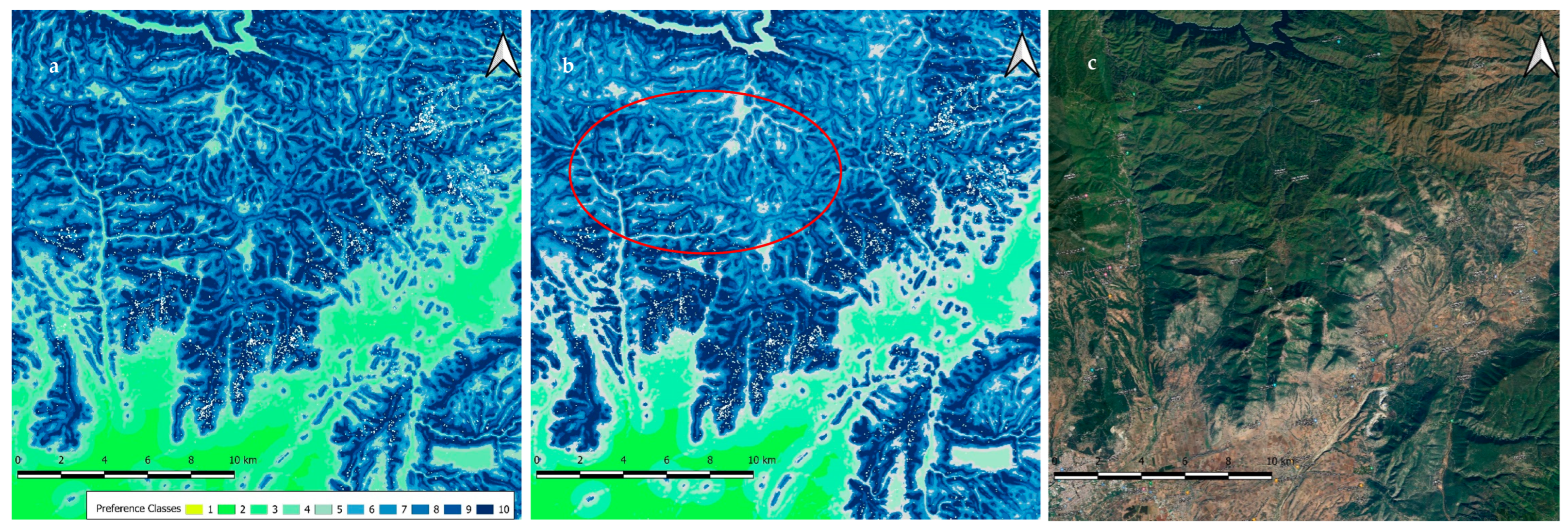
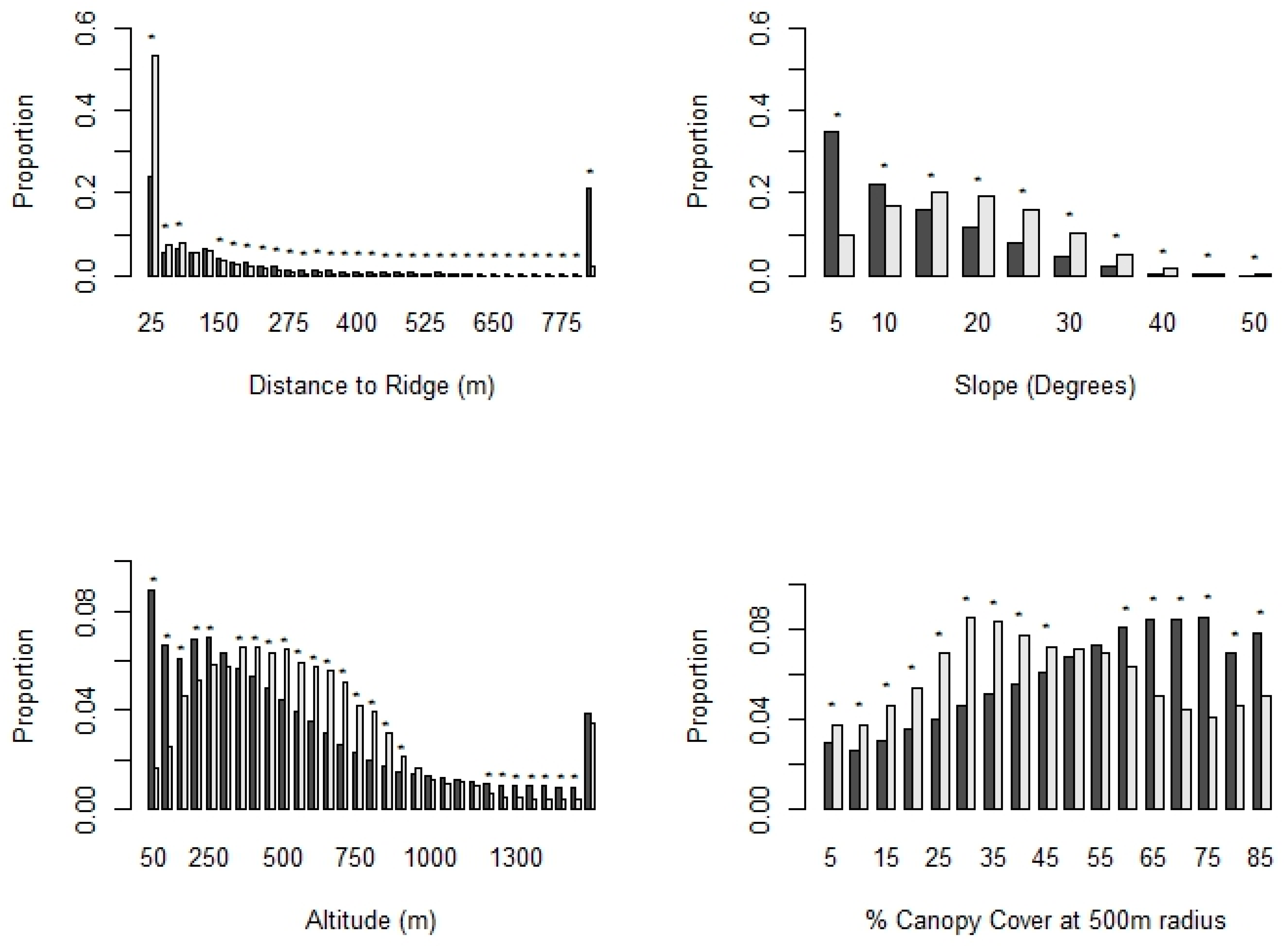
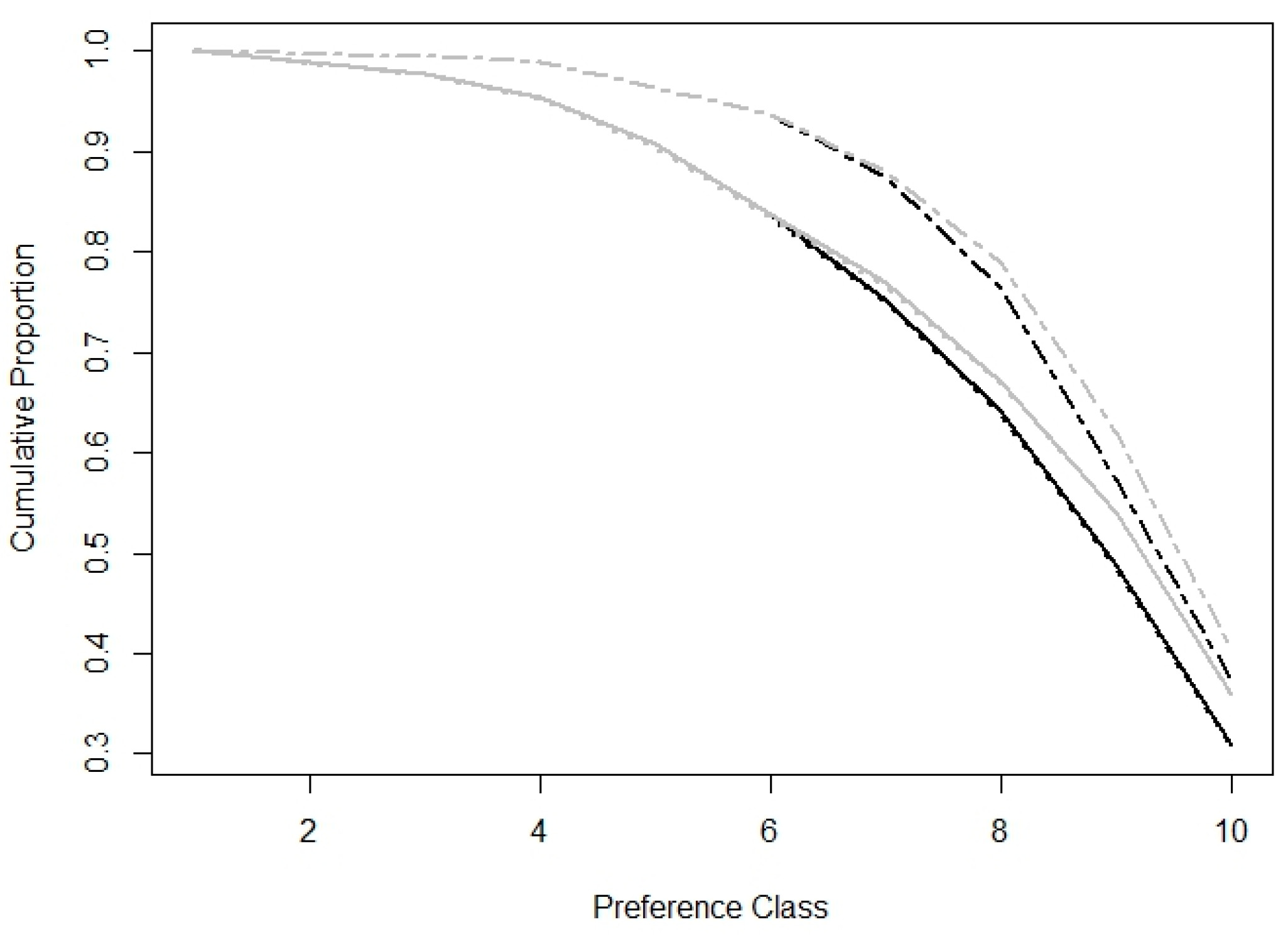
Golden eagles showed marked preferences for areas close to ridges up to 75 m, with steeper slopes (>10°) and intermediate altitudes (300–1000 m). The distance bands of 75–125 m to ridge pixels were used proportionally to availability and greater distance bands were underused. Eagles avoided lowland flat areas (slope < 10° and below 250 m altitude), and all other altitudinal zones were used proportionally to availability, apart from the zones of 1150–1300 m, which were used less than expected (Figure 6). In the implementation of the GETc model, we found dispersing golden eagles showed a marked preference for focal canopy covers of <45%. Higher cover classes up to 60% were used proportionally and greater cover classes were avoided. The addition of the tree cover density in the high-suitability classes of the topographic model increased the proportion of data classified in the top preference classes pixels (Figure 7). In the visual interpretation of maps (Appendix A, Figure A2), the suitability of homogeneous densely forested areas was lowered.
In the visual interpretation of maps (Appendix A, Figure A2), the suitability of homogeneous densely forested areas was lowered.
Both models, when rendered over the entire N. Greece–Bulgaria land area, indicated approximately 6.6–6.8% of the total land area (10,193–10,422 km2) as at the top preference class for golden eagle dispersal and 21.5% as the three upper suitability classes (Table 2, Figure 8).

3.5.2. Preferences within Temporary Settlement Areas

Friedman’s tests and pairwise comparisons indicated differences between some variables in the MCP, MKDE 95% isopleth and core area contrasts: the order generally proceeded towards less agricultural and more natural habitats, more open land and rougher topography. Roads were less prominent in MKDE polygons than in the MCP but not in the core area vs. 95% isopleth contrast. Turbines were less prominent in core areas than in the surrounding landscapes (Table A2).
The conditional regression model (Table 3 and Table 4) indicated that when temporarily settled, eagles concentrated their activity in a subset of the wider area that displayed steeper slopes and a higher percentage of land with under 50% canopy cover or landscape heterogeneity as expressed by the division index of open vs. closed canopy cover. Fitting both parameters, although marginally correlated (r > 0.45), resulted in a lower AICc, but model parameters were not significant and division estimate CIs overlapped 1 (Table 3).
Seasonal models with a higher number of polygons were similar (Table A3 and Table A4). Fitting an interaction of eastness with season in the final model slightly improved it, suggesting a preference for more eastern exposures in winter, retaining significance across all parameters (Table A3 and Table A4), but without a marked improvement of AICc. Adding only eastness to the model, or any other interaction, was rejected. Topography (slope), however, had by far the highest influence in every case, accounting for >80% of the fitted concordance when fit singly.
GET scores increased in the order of MCPs, MKDE 95% and core area isopleths for the GET and GETc models and these differences were significant in Friedman’s tests and pairwise Wilcoxon’s comparisons at p < 0.0001 (Figure 9).

4. Discussion

4.1. Dispersal Onset and Ranging

Our study provides the first insights on dispersal ecology and behavior from this part of the species distribution. Golden eagles in northern Greece disperse later than in Scotland and North America, populations where the same method has been deployed for the determination of dispersal onset, but nearly at the same time as eagles in southern France [12,14,73,74]. Delayed dispersal might confer benefits in terms of increased possibilities to hone crucial foraging skills [75], and raptors are known to actively acquire foraging abilities through learning during the PFDP [76,77]. Our study population displays a high dietary specialization (tortoises) with associated prey-handling requirements that are probably learned [44], something a prolonged PFDP can accommodate. Given the paucity of tortoises during winter months, eagles depending for longer periods on their parents during their crucial first winter can also benefit beyond parental provisioning from the possibility of acquiring hunting skills for more agile prey. The prolonged PFDP fitness hypothesis was also supported in the French and Scottish populations studied, as eagles, despite having developed sufficient flight skills, did not necessarily depart early from natal areas [74,75]. Some of our individuals did not even distance themselves away from the natal home range after fulfilling the onset criteria and even returned for brief periods that qualified for temporary settlement, in this case probably benefiting from parental tolerance, possible further provision and familiarity with the local environment.
All our studied individuals would be classified as short-distance dispersers, ranging mostly <120 km in their first post-dispersal months (sensu [73], a tactic also found to confer higher survival rates [73,78]. Several explanations might account for this pattern. A large number of territories might be vacant and offer suitable eagle habitat close by. Also, the widespread and highly available main prey in dispersal areas, as well as the extensive grazing livestock in dispersal areas, might additionally explain the low need for long-range dispersal. We did not detect seasonal differences in sizes between the wider dispersal areas (95% MKDE isopleths) nor correlations between size and number of tracking seasons, implying a relative stability of space transversed, at least regarding the main areas used by the birds.

4.2. Temporary Settlement Behavior

The identification of TSAs and high-quality dispersal habitat in general can be valuable in the spatial prioritization of targeted conservation actions [18,24]. We developed a selection algorithm for the definition of TSAs based on spatial and temporal thresholds under biological support, rendering areas of relatively restricted size and where the eagles remained for a continuous, substantial amount of time. Our moving window length corresponds to the 10 days of the initial settlement identification step of [56] and the threshold set for selection of temporary settlement areas in juvenile white-tailed eagles [55]. It is close to the average (12 days) temporary settlement period recorded by [29] for Spanish imperial eagles (Aquila adalberti) and considerably longer (and thus conservative) than half this value (six days) used for delineating the TSAs of the same species in the Iberian Peninsula and Africa [79]. Our definition of the TSA and its spatial outer boundaries are easy to compute and are not particularly data- or computationally intensive. We found considerable variation in temporary settlement tactics from nearly 0 to a very substantial time of the NDP (>70%) spent in TSAs, consistent with the golden eagle’s other aspects of dispersing and prospecting behavior [16].
TSAs reported for Spanish imperial eagles in the Iberian Peninsula were similar in size [79] but frequency of use by tracked individuals was higher [28,79]. White-tailed eagle TSAs delineated in central Europe were much larger, although again the criterion was not size-constrained with a home range estimator [55]. Other authors used more generic methods without implementing spatial and temporal constraints and our results are not directly comparable (e.g. [27]). A sharp increase in the UD size was found by [24] for Bonelli’s eagles (Aquila fasciata), which could be comparable to our overall core dispersal areas but the sizes have not been reported and the UD estimation methods were different and had less frequently sampled datasets. We believe that our method offers a flexible, straightforward way to delineate continuous temporary settlement behavior in space and time, that may be adaptable to other raptor species, given different thresholds.
Areas used intensively during TSEs were restricted, regarding the 95% MKDE isopleths and, especially, the core areas. While core area sizes were not different between seasons, the 95% isopleth areas were larger during winter. [80] suggested that summer prey availability and occurrence of suitable flight conditions are higher in Mediterranean areas, and this could suggest that eagles might need to cover less extensive areas for foraging, especially considering the abundance and ease of capture of their main prey in our population.
One of the factors possibly affecting the selection of TSAs is nearby territory occupancy. We do not have detailed occupancy data of all the territories in the vicinity of TSEs during the instances of TS behavior. We had reliable information for 11 cases where core areas intersected with 1 km buffers of occupied territories (latest nests in use). Of these, only four did not concern individuals that were either returning to their natal nest or later settling in that territory and the minimal overlap did not include the nest location itself. In principle, although intrusions of occupied ranges during dispersal are regular [8,16], temporary settlement areas of large eagles are generally not overlapping breeding territories due to competitive exclusion [24,28]. Nearly half (53) of our TSEs encompassed territories most likely abandoned at the time of use and this might support the competitive exclusion of younger birds from occupied territories.
Another confounding factor that we could not account for is the predictable occurrence of carcasses or other prey in certain areas. Carrion can be a substantial part of the golden eagle diet in the Mediterranean [81,82] and is more utilized during winter months in our population [44]. Our eagles have visited supplementary feeding sites for vultures and some TSAs included them within their boundaries. In at least four more cases, refuse tips where carrion might be irregularly disposed of and/or are certain to attract potential prey species such as gulls (Laridae) and small carnivores (both prey items used in our study population’s diet, especially in winter [44]) were encompassed by TSAs. Carrion can occur also irregularly in the wild or in unofficial disposal areas in areas with high livestock densities but it is not possible to precisely map these locations, unless such incidents are ground truthed [83]. Lastly, we could not test for differences between sexes in any of our analyses due to a highly skewed ratio in our chicks and our overall small sample size.

4.3. Territorial Settlement

Natal dispersal distances for our three individuals were within the reported distances from Scotland, the US and Spain [10,84,85]. Our small sample size of settled birds precludes any further conclusion regarding natal dispersal distance. An interesting pattern occurred, however, regarding the relationship between temporary and territorial settlement. Two birds displayed TS behavior in the months prior to settlement, around their final settlement areas (69 days before for 11 days in one instance and four events totaling 110 days starting 122 days prior to settlement). Both birds performed TS events in a radius of 10 km from the final settlement locations, six of a total duration of 74 days at least 252 days prior to settlement in one case and eight of a total duration of 177 days, at least 407 days prior to settlement, in the second, suggesting extensive prior knowledge of the area and a potential transitional period of prospecting either a territorial vacancy or even potential nest sites after pairing up. Indeed, one female repeatedly visited the exact ledge of a nest site in an unoccupied territory, with no signs of occupancy, for more than one decade, several months before settling, approximately 11 km to the south where she attempted breeding the following year. The third settled individual that was recruited in the 5th calendar year had no prior temporary settlement behavior close to its final territorial settlement location, although it had repeatedly crossed the wider area during dispersal. Although our very small sample size cannot be used to infer conclusions at the population level, this might be indicative of variation in prospecting behavior already documented for the species [16].

4.4. Habitat Preferences

Eagles seemed to select areas with greater relief incorporating open habitats both during the overall dispersal period (as indicated by the implementation of the GET model) and during stays in TSAs. The successful implementation of the GET model confirmed the importance of topography for a species relying on orographic and thermal updrafts [35,37,38,86,87], with eagles preferring areas close to ridges and steeper slopes. Aspect, as in Scotland [37], was not selected as a variable in the model, perhaps counterintuitively since thermal uplift can be important in southern latitudes [24] and mountainous landscapes [88]. Further testing for seasonal and intra-diel variation might reveal such patterns.
Applying the criterion of the focal canopy cover improved the model and shifted the distribution of cells in the higher preference classes. Closed canopy woodland has been found to have negative effects on resident golden eagle occupancy and productivity in Scotland [89], albeit concerning uniform, commercial forestry monocultures. Forest cover was also negatively related to golden eagle home range size in Canada [90] and productivity in the Alps [40]. In addition, Scandinavian golden eagles have been found to actively seek clear cuts and forest edges throughout different life stages [39,42,91]. We therefore expected that golden eagles would use open areas at a higher level than their availability and this was largely confirmed from the GETc model. While topography is immutable and provides a fixed landscape habitat for energetic economy [37], the incorporation of the cover variable allowed us to examine habitat preferences in the current state. While landscape heterogeneity was not tested in the implementation of the GET model, it showed a possible positive link with eagle space use within temporary settlement areas. Habitat heterogeneity has also been found to be important for golden eagles in Spain, where golden eagles selected orchards, pastures and other human-modified landscapes rich in preferred prey [25,26,92], and a similar process might be operating in northern Greece (see Section 5). Favoring mosaics of open areas, at least in the breeding period, is also consistent with potential high tortoise availability [93,94].
TSA selection and use, however, showed again the overriding importance of complex topography and the complementary role of habitat type. Land cover types, although important in univariate comparisons, were not selected in our models, as they are highly correlated to topography (intuitively, as, e.g., higher slopes are less likely to be cultivated and more likely to be covered by woods and pasture in human-altered landscapes) and our smaller sample size did not allow the incorporation of more complex variables such as woodland type. In turn, habitats in TSA cores encompass more optimal conditions and therefore the utilization of a single canopy cover variable, that seems to be the second most important element after topography, might be unlikely to mask more complex patterns. Both approaches (overall dispersal area with the GET model implementation and habitat within TSAs) yielded similar results to TSAs incurred higher GET and GETc scores in our core areas, as verified by the comparisons.
Our results regarding the anthropogenic variables in univariate comparisons were not unanimous. Eagles did not seem to avoid roads, perhaps because we did not discriminate road types. Additionally, some forest roads can serve as openings in scrub and woodlands and enhance potential prey capture opportunities (e.g., tortoises feeding on roadside grasses and forbs) or be connected to extensive livestock stables that provide carcasses and open areas through grazing. Core areas always had a lower number of wind turbines per unit area than the surrounding range areas, suggesting the possible avoidance of wind turbines as demonstrated elsewhere [95].

5. Conservation Implications

Golden eagles in our study area used areas of intense topographical relief and low to intermediate canopy covers. These habitats have been gradually degraded, as forest expansion, a decades-long process, continues in extensive parts of our study area [96,97,98] and is affecting both prey numbers and prey accessibility [44,99]. Wildfires are also an increasing threat to the golden eagle’s habitats and food supply, with several territories and TSAs of our population recently affected by one of the largest megafires in the EU (97,000 ha) [100]. Open habitats are more resilient to wildfires (a major threat to tortoise and other prey populations [101]) and are overall richer in biodiversity in Mediterranean landscapes [102], thus providing a wider spectrum of prey for golden eagles and other raptors [103,104]. Their maintenance is also linked to higher grazing with a subsequently higher availability of ungulate carcasses [81].
Of the seven dispersing eagles recovered dead during dispersal (all due to apparent anthropogenic causes), five were recovered dead within their TSAs and a sixth in the TSA of another bird that survived to adulthood. It is likely therefore that these areas of high suitability might be functioning as an ecological trap for our population, undermining the demographic component of dispersing eagles and floaters [31,32], and these locally operating threats might also explain a large number of territory vacancies [45,105]. The identification of TSAs is thus a crucial first step to the conservation of the declining northern Greek and Bulgarian population [45,105].
Threat mitigation in areas suitable for eagle dispersal, i.e., away from occupied territories, with intense topography and relatively open habitats, should be applied, such as careful wind farm planning, insulation of dangerous electricity pylons and vigilance against the illegal use of poisoned baits [25,26,106,107,108]. At the same time, proactive management including selective supplementary feeding in winter and maintenance of open areas through grazing and prescribed burning could be a potential measure of boosting survival of dispersing eagles. Management should be combined with public awareness campaigns publicizing telemetry findings and where the golden eagle can be widely perceived as a suitable sentinel species towards the mitigation of these threats [105,109]. Finally, abandoned territories should be conserved as suitable dispersal areas, beyond their potential for recolonization even after prolonged vacancies [110,111].

Author Contributions

Conceptualization, L.S., D.P.W. and K.P.; methodology, L.S., V.K. and D.P.W.; software L.S.; validation, L.S. and E.N.; formal analysis, L.S. and V.K.; investigation, L.S., E.N., A.B., E.K. and D.P.V.; resources, D.P.W., L.S., K.P., E.K. and V.K.; data curation, L.S.; writing—original draft preparation, L.S., V.K. and D.P.W.; writing—review and editing, all authors; visualization, L.S.; supervision, V.K. and K.P.; project administration, L.S. and V.K.; funding acquisition, D.P.W., L.S. and E.K. All authors have read and agreed to the published version of the manuscript.

Funding

The funding of the tags and data download costs notably came from (1) Natural Research through a grant to L.S. (seven tags), (2) the Hellenic Natural Environment and Climate Change Agency (NECCA) through the project “Monitoring raptors through Satellite Telemetry”, implemented by Nature Conservations Consultants Ltd under contract in the Transport Infrastructure, Environment and Sustainable Development (TIESD) 2014–2020, co-funded by the 4th EC Community Support Framework and (3) the Society for the Protection of Biodiversity of Thrace contributed three tags through the program “Fighting poisoning–reducing vulture (and other scavenger and predator) mortality due to the use of poison baits and lead ammunition across the Mediterranean” which was financed by the Vulture Conservation Foundation and the MAVA Foundation and co-financed by WWF Greece. The Hellenic Ornithological Society /BirdLife Greece, Nature Conservation Consultants (NCC Ltd.) and Dr Ivan Literak provided one tag each. Manuscript production was financially supported by Natural Research. L.S. has also received AG Leventis Foundation scholarship grants.

Institutional Review Board Statement

All research was conducted under the appropriate annual research permits issued by the Department of Forest Management of the Directorate General of Forests and Forest Environment of the ministry of Environment and Energy of Greece [Protocol codes/dates 2736/65/06.02.2023, 123931/4023/15.01.2022, 755/134/01.01.2021, 1033/16/04.02.2020, 16563880/80/22.01.2018, 175837/2197/27.11.2018].

Data Availability Statement

Data is contained within the article. Due to restrictions pertaining to spatial information of Sensitive Species under Greek Law and additionally, ownership of parts of the data by a third party, the authors cannot publish raw data.

Acknowledgments

The GET model analysis benefitted greatly from advice by Alan H. Fielding. The manuscript was substantially improved through comments of Ivaylo D. Angelov. The SPBT provided substantial logistics and fieldwork assistance during the investigation. Nest access and tagging would have been impossible without the aid of Archontis Exacoidis, Dobromir Dobrev and Emil Yordanov, Walter Nesser, Yotam Orchan and Athanasios Chalivelentzios. P. Azmanis assisted in tagging and had the overall veterinary oversight of the research.

Conflicts of Interest

The authors declare no conflict of interest.

Appendix A

Table A1. Details of tagged eagles. + signs indicate analyses where data of each individual were used.
Individual (Ring Number)SexDate TaggedLast Day of Dispersal TrackingTag ModelTag
Attachment
n of Raw Fixes
Retrieved
Fix Intervals (Seconds)Analyses Where Data Used
Dispersal OnsetTemporary SettlementTerritorial SettlementHabitat Use
M000413—HEAG01F 17 July 201416 May 2015ECOTONE KITEBP30163600+
M000414—WEE_BUGM20 June 20185 June 2019ECOTONE KITEBP13253600+
M000422—ARCHONTASM 115 June 20196 February 2022Ornitela OT50BP129,999300++++
M000426—ROYM 124 June 201916 August 2019Ornitela OT50BP252164
M000434—LUCIAF 15 July 202015 March 2022Ornitela OT50BP122,567300++++
M000429—AIMOM 129 June 20194 December 2020Ornitela OT50BP83,684300++++
M000423—LADIM 120 June 201919 September 2021Ornitela OT50BP135,188300++++
M000424—DOBRIM 120 June 201925 September 2019Ornitela OT50BP8103181
M000433—ANASIAF 127 June 20205 March 2023Ornitela OT50BP198,745299++++
M000425—AKRITASM 122 June 20192 September 2020Ornitela OT50BP99,809180++++
M000427—APOSTOLIAF 128 June 20194 July 2022Ornitela OT50PH199,471299++++
M000428—PANAGIOTAMM 127 June 201920 January 2021Ornitela OT30PH55,000300++++
M000435—PATRICKM 28 July 202123 June 2022Ornitela OT50BP40,805300++++
M000436—LORCAF 119 June 202218 December 2023Ornitela OT50PH9625300++++
M000437—RASPUTINM22 January 202221 December 2022Ornitela OT50BP33,897300++++
M000440—FREEDOMM6 July 202215 March 2024Ornitela OT50BP13,901300++++
M900551—LOLAF 129 June 202329 March 2024Ornitela OT50PH28,588300+
M900552—ALANM 130 June 202315 March 2024Eobs Solar 55PH32,698300+ +
M900553—MOONCHILDM 11 July 202428 January 2024Ornitela OT50PH17,896300++ +
M900554—VALIENTEM 17 January 202415 March 2024Ornitela OT50PH22,169300++ +
Sexing: 1 Confirmed molecularly; 2 Confirmed post mortem; Otherwise morphometric that was initially applied to all chicks during tagging. Attachment: BP: Backpack, PH: Pelvic (leg loop) harness.
Table A2. Friedman’s and pairwise Wilcoxon’s tests on single-variable exploratory analysis of TSA habitat use.
MCP vs. 95% MKDE95% vs. Core Area MKDE
VariableFriedman’s HpMean DifferenceWilcoxon’s Matched PairspMean DifferenceWilcoxon’s Matched Pairsp
% Extensive agriculture 163.250.00006.79126102.129900
% Woods and scrub 212.490.0019−3.754100.007−1.456180.39
% Open and transitional habitats 33.660.1604−3.394880.044−0.376550.595
% Natural vegetation 452.890.0000−7.141090−1.822960.001
Tree cover density 55.550.06240.466820.771.5810910.001
% Area with <50% cover 65.020.0813−1.226760.73−2.753080
% Ridge pixels 765.250.0000−6.41350−5.71870
Northness 85.250.07260.039730.023−0.015580.165
Eastness 80.150.9273−0.016710.69706830.777
Slope 951.660.0000−1.71170−1.131320
Altitude 99.510.0086−8.034670.0281.816250.426
Road density (km/km2) 108.190.01670.519850.017−0.414570.022
Turbines/km2 1116.000.00030880.9310.03360.014
Division 1287.960.0000−22300−81140
1 Classes of CLC 211, 241, 242, 243, 244; 2 Classes of CLC 311, 312, 313, 323; 3 Classes of CLC 231, 321, 322, 324, 331, 332, 333, 334, 335; 4 Combination of reclassified woods and open and transitional habitats rasters; 5 Tree cover density, raw percentages; 6 Tree cover density < 50%; 7 From European DEM, applying algorithm of Fielding et al. 2019, changing threshold to 26 m corresponding to our cell size (half of the original 50 m cell size); 8 Cos (Aspect) and Sin (Aspect); 9 European DEM and derivatives; 10 Roads from [112]; 11 REGULATORY AUTHORITY FOR ENERGY (2024) [113]; 12 Division index between open (<50% canopy cover) and dense (>50%) areas.
Table A3. Model Selection for seasonal models. Variables in bold are those selected at each step.
ModelAICcConcordanceLRLR Pχ2p
Slope48.260.8431.5<0.0001
% Open 80.450.6610.330.001
Division59.890.8130.89<0.0001
Slope + % Open40.510.8652.41<0.00019.89<0.002
Slope + Division43.350.8749.56<0.00017.04<0.01
Slope + Open + Division37.890.9157.23<0.00014.82<0.03
Slope + Open + Division + Eastness + Eastness: Season36.40.9263.35<0.00016.1<0.05
Table A4. Coefficients for models incorporating season (n = 64 polygon sets).
ModelVariableCoefficientOddsLower CIUpper CIZp
Slope + Open + Division [Season n = 64]Slope1.504.51.7711.423.150.002
% Open0.171.181.031.352.430.015
Division0.101.110.981.251.640.1
Slope + Open + Division + Eastness + Eastness: SeasonSlope2.088.062.0132.552.930.003
% Open0.211.231.061.432.770.006
Division0.241.271.021.572.140.03
Eastness−0.230.790.650.97−2.210.03
Eastness: Season0.261.301.011.672.080.04
Figure A1. (a) Settlement graph for individual M000423 (above), not settled, and (b) individual M000434 (below) settled in a breeding territory. Red points indicate distance between roosts 10 days apart and black points the distance to the putative territory center (median coordinates of last 20 days of tracking roosts). The horizontal line indicates the 15 km distance threshold and the blue vertical line the date of territory settlement.
Diversity 16 00580 g0a1aDiversity 16 00580 g0a1b
Figure A2. Visualization of the GET model (a, left), the GETc model (b, center) and the depicted landscape (c, right), Google Hybrid™. Overall suitability in the GETc model was lower in areas of uniform forest cover (e.g., areas enclosed in red ellipse). White dots represent the locations of three individuals.
Diversity 16 00580 g0a2

Appendix B

Appendix B.1. GET and GETc Model Supplementary Notes

We filtered out fixes with horizontal dilution of precision (hdop) values ≤ 2 to be more consistent with our higher spatial resolution (the original GET model used 50 m cells and a 3.5 hdop threshold), discarding < 2% of the data, retaining 69854 fixes, that we randomly split into a training (75%) and testing (25%) datasets. Data from the dispersal period of three individuals (whose transmitters provided no hdop measurements) were used as an independent testing dataset (n = 1630 locations).
We ran 1000 random training data sample (without replacement) extracts and for each variable class calculated the empirical confidence intervals (mean ± 2 SD) from the distributions for PIs and raw proportions. We finally multiplied the standardized median PIs (each PI as a proportion of the class PI sums) by 1000 and each cell was assigned its class value. Scores were added across variables for each cell. The resulting raster (summed values ranging from 14.4 to 474.6) was split into deciles and cells were assigned to the final preference class (1–10). This reclassified raster was the final topographic model.
Regarding canopy cover in the GETc model, given that agricultural areas in lowland flat areas avoided by golden eagles are also by default open, which would confound the analysis, we tested this under the overriding influence of topography, constraining use and availability in higher predicted use cells only (preference class ≥ 6). We achieved this by adding the scaled standardized preference index in the cells of topographic suitability class of at least 6 and recalculating the decile distribution of classes. In effect, this allowed us to redistribute the suitability class scores in the upper-half classes of the model based on the focal canopy cover.

Appendix B.2. Stepwise Model Selection of Conditional Logistic Regression Modeling

We first fitted variables individually and in each case retained the one with the lowest AICc, extracted with the MuMIn R library [114]. Candidate models with the same number of variables and ΔAΙCc < 1 were selected based on added term significance. We subsequently fitted all single remaining variables and retained additions if the AICc was lower, and χ2 goodness of fit tests between models suggested a justified addition of the variable (Table 2). We stopped adding variables when ΔAICc < 2 for a single variable or 4 for interactions with season. At each step, we removed variables correlated (r > 0.6) to previously retained model variables and fitted interactions between retained variables. At the final stage, we fitted any possible remaining variable as an interaction with season to detect if any seasonal effects persist.

References

  1. Serrano, D. Dispersal in Raptors. In Birds of Prey Conservation in the XXI Century; Sarasola, J.H., Grande, J.M., Negro, J.J., Eds.; Springer International Publishing: Cham, Switzerland, 2018; pp. 95–121. ISBN 978-3-319-73745-4. [Google Scholar]
  2. Wright, S. Evolution in Mendelian Populations. Bull. Math. Biol. 1931, 52, 241–295. [Google Scholar] [CrossRef] [PubMed]
  3. Penteriani, V.; Delgado, M.M. Birthplace-Dependent Dispersal: Are Directions of Natal Dispersal Determined a Priori? Ecography 2011, 34, 729–737. [Google Scholar] [CrossRef]
  4. Poessel, S.A.; Woodbridge, B.; Smith, B.W.; Murphy, R.K.; Bedrosian, B.E.; Bell, D.A.; Bittner, D.; Bloom, P.H.; Crandall, R.H.; Domenech, R.; et al. Interpreting Long-Distance Movements of Non-Migratory Golden Eagles: Prospecting and Nomadism? Ecosphere 2022, 13, e4072. [Google Scholar] [CrossRef]
  5. Stamps, J.A. Habitat Selection by Dispersers: Integrating Proximate and Ultimate Approaches. In Dispersal; Clobert, J., Danchin, E., Dhondt, A.A., Nichols, J.D., Eds.; Oxford University Press: Oxford, UK, 2001; pp. 230–242. ISBN 978-0-19-850660-7. [Google Scholar]
  6. Watson, J. The Golden Eagle; Poyser: London, UK, 2010. [Google Scholar]
  7. Morrison, J.L.; Wood, P.B. Broadening Our Approach to Studying Dispersal in Raptors. J. Raptor Res. 2009, 43, 81–89. [Google Scholar] [CrossRef]
  8. Whitfield, D.P.; Fielding, A.H.; Anderson, D.; Benn, S.; Reid, R.; Tingay, R.; Weston, E.D. Seasonal Variation in First Territory Settlement of Dispersing Golden Eagles: An Innate Behaviour? Diversity 2024, 16, 82. [Google Scholar] [CrossRef]
  9. Soutullo, A.; Urios, V.; Ferrer, M.; Peñarrubia, S.G. Post-Fledging Behaviour in Golden Eagles Aquila Chrysaetos: Onset of Juvenile Dispersal and Progressive Distancing from the Nest. Ibis 2006, 148, 307–312. [Google Scholar] [CrossRef]
  10. Urios, V.; Soutullo, A.; López-López, P.; Cadahía, L.; Limiñana, R.; Ferrer, M. The First Case of Successful Breeding of a Golden Eagle Aquila Chrysaetos Tracked from Birth by Satellite Telemetry The First Case of Successful Breeding of a Golden Eagle Aquila Chrysaetos Tracked from Birth by Satellite Telemetry. Acta Ornithol. 2007, 42, 205–209. [Google Scholar] [CrossRef]
  11. The Golden Eagle around the World; Bautista, J.; Ellis, D.H. (Eds.) Hancock House Publishers: Blaine, WA, USA; Surrey, BC, Canada, 2024. [Google Scholar]
  12. Cruz-Romo, L.J.; Sanchez-Vilchis, M.; Sanchez-Cordero, V.; Murphy, R.K.; Cruz-Molina, I.; Vargas-Velasco, J.J.; Valdes-Alargon, M.; Millsap, B.A. First Satellite Telemetry Study of Movement Behavior of Juvenile Golden Eagles from Mexico. J. Raptor Res. 2022, 56, 28–39. [Google Scholar] [CrossRef]
  13. Cadahía, L.; López-lópez, P.; Urios, V.; Negro, J.J. Estimating the Onset of Dispersal in Endangered Bonelli ’ s Eagles Hieraaetus Fasciatus Tracked by Satellite Telemetry: A Comparison between Methods. Ibis 2008, 150, 416–420. [Google Scholar] [CrossRef]
  14. Weston, E.D.; Whitfield, D.P.; Travis, J.M.J.; Lambin, X. When Do Young Birds Disperse? Tests from Studies of Golden Eagles in Scotland. BMC Ecol. 2013, 13, 42. [Google Scholar] [CrossRef]
  15. Delgado, M.M.; Penteriani, V. Behavioral States Help Translate Dispersal Movements into Spatial Distribution Patterns of Floaters. Am. Nat. 2008, 172, 475–485. [Google Scholar] [CrossRef] [PubMed]
  16. Fielding, A.H.; Anderson, D.; Benn, S.; Reid, R.; Tingay, R.; Weston, E.D.; Whitfield, D.P. Substantial Variation in Prospecting Behaviour of Young Golden Eagles Aquila Chrysaetos Defies Expectations from Potential Predictors. Diversity 2023, 15, 506. [Google Scholar] [CrossRef]
  17. Whitfield, D.P.; Fielding, A.H.; Mcleod, D.R.A.; Haworth, P.F. Modelling the Effects of Persecution on Population Dynamics of Golden Eagles in Scotland. Biol. Conserv. 2004, 119, 319–333. [Google Scholar] [CrossRef]
  18. Whitfield, D.P.; Fielding, A.H.; Mcleod, D.R.A.; Haworth, P.F. A Conservation Framework for Golden Eagles: Implications for Their Conservation and Management in Scotland. Scott. Nat. Herit. Comm. Rep. 2008, 193, 151. [Google Scholar]
  19. Hernández-Matías, A.; Real, J.; Parés, F.; Pradel, R. Electrocution Threatens the Viability of Populations of the Endangered Bonelli’s Eagle (Aquila Fasciata) in Southern Europe. Biol. Conserv. 2015, 191, 110–116. [Google Scholar] [CrossRef]
  20. Newton, I.A.N.; Mcgrady, M.J.; Oli, M.K. A Review of Survival Estimates for Raptors and Owls. Ibis 2016, 158, 227–248. [Google Scholar] [CrossRef]
  21. Pain, D.J.; Donald, P.F. Outside the Reserve: Pandemic Threaths to Bird Biodiversity. In Conserving Birds Biodiversity General Principles and their Application; Norris, K., Pain, D.J., Eds.; Cambridge University Press: Cambridge, UK, 2002; pp. 157–179. [Google Scholar]
  22. Orgeret, F.; Grüebler, M.U.; Scherler, P.; Bergen, V.S.V.; Kormann, U.G. Shift in Habitat Selection during Natal Dispersal in a Long-Lived Raptor Species. Ecography 2023, 2023, e06729. [Google Scholar] [CrossRef]
  23. Whitfield, D.P.; Fielding, A.H.; McLeod, D.R.A.; Haworth, P.F.; Watson, J. A Conservation Framework for the Golden Eagle in Scotland: Refining Condition Targets and Assessment of Constraint Influences. Biol. Conserv. 2006, 130, 465–480. [Google Scholar] [CrossRef]
  24. Balbontín, J. Identifying Suitable Habitat for Dispersal in Bonelli’s Eagle: An Important Issue in Halting Its Decline in Europe. Biol. Conserv. 2005, 126, 74–83. [Google Scholar] [CrossRef]
  25. Bautista, J.; Gómez, G.J.; Otero, M.; Garrido, J.R. Golden Eagles in Southern Spain Recolonize Human-Dominated Landscapes (1998–2021). In The Golden Eagle Around the World; Bautista, J., Ellis, D.H., Eds.; Hancock House Publishers: Blaine, WA, USA; Surrey, BC, Canada, 2024; pp. 220–253. [Google Scholar]
  26. Bautista, J.; Otero, M.; Gómez, G.J.; Garrido, J.R. Golden Eagles and Humans: Expansion into Human Dominated Landscapes; Wilder Sur: Granada, Spain, 2022. [Google Scholar]
  27. Cadahía, L.; López-López, P.; Urios, V.; Negro, J.J. Satellite Telemetry Reveals Individual Variation in Juvenile Bonelli’s Eagle Dispersal Areas. Eur. J. Wildl. Res. 2010, 56, 923–930. [Google Scholar] [CrossRef]
  28. Ferrer, M. Juvenile Dispersal Behaviour and Natal Philopatry of a Long-lived Raptor, the Spanish Imperial Eagle Aquila Adalberti. Ibis 1993, 135, 132–138. [Google Scholar] [CrossRef]
  29. Ferrer, M. Reduction in Hunting Success and Settlement Strategies in Young Spanish Imperial Eagles. Anim. Behav. 1993, 45, 406–408. [Google Scholar] [CrossRef]
  30. Hunt, G. A Pilot Golden Eagle Population Study in the Altamont Pass Wind Resource Area in California; Predatory Bird Research Group: Santa Cruz, CA, USA, 1995; p. 219. [Google Scholar]
  31. Penteriani, V.; Otalora, F.; Sergio, F.; Ferrer, M. Environmental Stochasticity in Dispersal Areas Can Explain the ‘Mysterious’ Disappearance of Breeding Populations. Proc. R. Soc. B Biol. Sci. 2005, 272, 1265–1269. [Google Scholar] [CrossRef] [PubMed]
  32. Penteriani, V.; Otalora, F.; Ferrer, M. Floater Survival Affects Population Persistence. The Role of Prey Availability and Environmental Stochasticity. Oikos 2005, 108, 523–534. [Google Scholar] [CrossRef]
  33. Real, J.; Bosch, R.; Tinro, A.; Hernandez-matias, A. Identifying Key Habitats for the Conservation of Bonelli ’s Eagle Aquila Fasciata Using Radio- Tracking. Ibis 2016, 158, 556–568. [Google Scholar] [CrossRef]
  34. Real, J.; Mañosa, S. Demography and Conservation of Western European Bonelli’s Eagle Hieraaetus Fasciatus Populations. Biol. Conserv. 1997, 79, 59–66. [Google Scholar] [CrossRef]
  35. Braham, M.; Miller, T.; Duerr, A.E.; Lanzone, M.; Fesnock, A.; LaPre, L.; Driscoll, D.; Katzner, T. Home in the Heat: Dramatic Seasonal Variation in Home Range of Desert Golden Eagles Informs Management for Renewable Energy Development. Biol. Conserv. 2015, 186, 225–232. [Google Scholar] [CrossRef]
  36. Dennhardt, A.J.; Duerr, A.E.; Brandes, D.; Katzner, T.E. Modeling Autumn Migration of a Rare Soaring Raptor Identifies New Movement Corridors in Central Appalachia. Ecol. Model. 2015, 303, 19–29. [Google Scholar] [CrossRef]
  37. Fielding, A.H.; Haworth, P.F.; Anderson, D.; Benn, S.; Dennis, R.; Weston, E.; Whitfield, D.P. A Simple Topographical Model to Predict Golden Eagle Aquila Chrysaetos Space Use during Dispersal. Ibis 2019, 162, 400–415. [Google Scholar] [CrossRef]
  38. McLeod, D.R.A.; Whitfield, D.P.; Fielding, A.H.; Haworth, P.F.; Mcgrady, M.J. Predicting Home Range Use by Golden Eagles Aquila Chrysaetos in Western Scotland. Avian Sci. 2002, 2, 183–198. [Google Scholar]
  39. Singh, N.J.; Moss, E.; Hipkiss, T.; Ecke, F.; Dettki, H.; Sandström, P.; Bloom, P.; Kidd, J.; Thomas, S.; Hörnfeldt, B. Habitat Selection by Adult Golden Eagles Aquila Chrysaetos during the Breeding Season and Implications for Wind Farm Establishment. Bird Study 2016, 63, 233–240. [Google Scholar] [CrossRef]
  40. Pedrini, P.; Sergio, F. Golden Eagle Aquila Chrysaetos Density and Productivity in Relation to Land Abandonment and Forest Expansion in the Alps. Bird Study 2001, 48, 194–199. [Google Scholar] [CrossRef]
  41. Whitfield, D.P.; Fielding, A.H.; Gregory, M.J.P.; Gordon, A.G.; McLeod, D.R.A.; Haworth, P.F. Complex Effects of Habitat Loss on Golden Eagles Aquila Chrysaetos. Ibis 2006, 149, 26–36. [Google Scholar] [CrossRef]
  42. Sandgren, C.; Hipkiss, T.; Dettki, H.; Ecke, F.; Hörnfeldt, B. Habitat Use and Ranging Behaviour of Juvenile Golden Eagles Aquila Chrysaetos within Natal Home Ranges in Boreal Sweden. Bird Study 2014, 61, 9–16. [Google Scholar] [CrossRef]
  43. Bounas, A.; Sidiropoulos, L. Aquila Chrysaetos. The Greek Red List of Threatened Species. Available online: https://redlist.necca.gov.gr/en/assessment/?id=224415705 (accessed on 8 June 2024).
  44. Sidiropoulos, L.; Whitfield, D.P.; Astaras, C.; Vasilakis, D.; Alivizatos, H.; Kati, V. Pronounced Seasonal Diet Diversity Expansion of Golden Eagles (Aquila Chrysaetos) in Northern Greece during the Non-Breeding Season: The Role of Tortoises. Diversity 2022, 14, 135. [Google Scholar] [CrossRef]
  45. Sidiropoulos, L.; Xirouchakis, S.; Alivizatos, H.; Boukas, N.; Bounas, A.; Bourdakis, E.; Christopoulos, A.; Damianakis, K.; Evangelidis, A.; Kret, E.; et al. The Golden Eagle in Greece. In The Golden Eagle Around the World; Ellis, D.H., Bautista, J., Ellis, C.H., Eds.; Hancock House Publishers: Blaine, WA, USA; Surrey, BC, Canada, 2024; pp. 397–415. [Google Scholar]
  46. Sidiropoulos, L. The Golden Eagle (Aquila Chrysaetos L.) in the Rhodope Mts: Modelling Densities, Distribution and Population Viability to Inform Conservation. Masters Thesis, Division of Biology. Imperial College London, London, UK, 2012. [Google Scholar]
  47. Bloom, P.H.; Kidd, J.W.; Hipkiss, S.E.T.; Kuehn, H.J. Trapping Success Using Carrion with Bow Nets to Capture Adult Golden Eagles in Sweden. J. Raptor Res. 2015, 49, 92–97. [Google Scholar] [CrossRef]
  48. Anderson, D.; Arkumarev, V.; Bildstein, K.; Botha, A.; Bowden, C.G.R.; Davies, M.; Duriez, O.; Forbes, N.A.; Godino, A.; Green, R.E.; et al. A Practical Guide to Methods for Attaching Research Devices to Vultures and Condors. Vulture News 2020, 78. [Google Scholar] [CrossRef]
  49. Fridolfsson, A.-K.; Ellegren, H. A Simple and Universal Method for Molecular Sexing of Non-Ratite Birds. J. Avian Biol. 1999, 30, 116–121. [Google Scholar] [CrossRef]
  50. Peshev, H.; Grozdanov, A.; Kmetova–Biro, E.; Ivanov, I.; Stoyanov, G.; Tsiakiris, R.; Marin, S.; Marinković, S.; Sušić, G.; Lisichanets, E.; et al. New Insight into Spatial Ecology of Griffon Vulture (Gyps Fulvus) on the Balkans Provides Opportunity for Focusing Conservation Actions for a Threatened Social Scavenger. Biodivers. Data J. 2021, 9, e71100. [Google Scholar] [CrossRef]
  51. Kranstauber, B.; Cameron, A.; Weinzerl, R.; Fountain, T.; Tilak, S.; Wikelski, M.; Kays, R. The Movebank Data Model for Animal Tracking. Environ. Model. Softw. 2011, 26, 834–835. [Google Scholar] [CrossRef]
  52. Benhamou, S. Dynamic Approach to Space and Habitat Use Based on Biased Random Bridges. PLoS ONE 2011, 6, e14592. [Google Scholar] [CrossRef]
  53. Calenge, C. Home Range Estimation in R: The adehabitatHR Package; Office National de la Classe et la Faune Sauvage: Auffargis, France, 2015. [Google Scholar]
  54. R-Core_Team. R: A Language and Environment for Statistical Computing. v 4.2.3; R Foundation for Statistical Computing: Vienna, Austria, 2023. [Google Scholar]
  55. Rymešová, D.; Raab, R.; Machálková, V.; Horal, D.; Dorňáková, D.; Rozsypalová, L.; Spakovszky, P.; Literák, I. First-Year Dispersal in White-Tailed Eagles Haliaeetus Albicilla. Eur. J. Wildl. Res. 2021, 67, 44. [Google Scholar] [CrossRef]
  56. Whitfield, D.P.; Fielding, A.H.; Anderson, D.; Benn, S.; Dennis, R.; Grant, J.; Weston, E.D. Age of First Territory Settlement of Golden Eagles Aquila Chrysaetos in a Variable Competitive Landscape. Front. Ecol. Evol. 2022, 10, 743598. [Google Scholar] [CrossRef]
  57. Powell, R.A. Animal Home Ranges and Territories and Home Range Estimatiors. In Research Techniques in Animal Ecology. 441pp; Boitani, L., Fuller, T.K., Eds.; Columbia University Press: New York, NY, USA, 2000; pp. 65–103. [Google Scholar]
  58. Thieurmel, B.; Elmarhraoui, A. Package “Suncalc”: Compute Sun Position, Sunlight Phases, Moon Position and Lunar Phase. Available online: https://cran.r-project.org/web/packages/suncalc/ (accessed on 10 December 2023).
  59. Hardey, J.; Crick, H.; Wernham, C.; Riley, H.; Etheridge, B.; Thompson, D. Raptors: A Field Guide to Survey and Monitoring; The Stationary Office: Edinburgh, UK, 2006. [Google Scholar]
  60. European Union/Copernicus Land Monitoring Service. CORINE Land Cover Dataset; European Environment Agency: København, Danmark, 2018. [Google Scholar]
  61. European Commission/Copernicus Land Monitoring Service. European Digital Elevation Model; European Environment Agency: København, Danmark, 2016. [Google Scholar]
  62. European Union/Copernicus Land Monitoring Service. High Resolution Tree Cover Density; European Environment Agency: København, Danmark, 2018; ISBN 2-01-220152-0. [Google Scholar]
  63. Hesselbarth, M.H.K.; Sciaini, M.; With, K.A.; Wiegand, K.; Nowosad, J. Landscapemetrics: An Open-source R Tool to Calculate Landscape Metrics. Ecography 2019, 42, 1648–1657. [Google Scholar] [CrossRef]
  64. McGarigal, K.; Cushman, S.A.; Ene, E. FRAGSTATS v4: Spatial Pattern Analysis Program for Categorical and Continuous Maps. Computer Software Program Produced by the Authors at the University of Massachusetts, Amherst. Available online: http://www.umass.edu/landeco/research/fragstats/fragstats.html (accessed on 10 May 2024).
  65. Crandall, R.H.; Bedrosian, B.E.; Craighead, D. Habitat Selection and Factors Influencing Nest Survival of Golden Eagles in South-Central Montana. J. Raptor Res. 2015, 49, 413–428. [Google Scholar] [CrossRef]
  66. Blondel, J.; Arronson, J. Biology and Wildlife of the Mediterranean Region; Oxford University Press: Oxford, UK, 1999. [Google Scholar]
  67. Grove, A.T.; Rackham, O. The Nature of Mediterranean Europe—An Ecological History; Yale University Press: New Heaven, CT, USA, 2001. [Google Scholar]
  68. Vander Wal, E.; Rodgers, A.R. An Individual-Based Quantitative Approach for Delineating Core Areas of Animal Space Use. Ecol. Model. 2012, 224, 48–53. [Google Scholar] [CrossRef]
  69. QGIS Development Team QGIS Geographic Information System v3.34. Available online: http://qgis.osgeo.org (accessed on 16 January 2024).
  70. Therneau, T.M. Survival: A Package for Survival Analysis in R. Available online: https://cran.r-project.org/web/packages/survival/vignettes/survival.pdf (accessed on 15 June 2024).
  71. Duchesne, T.; Fortin, D.; Courbin, N. Mixed Conditional Logistic Regression for Habitat Selection Studies. J. Anim. Ecol. 2010, 79, 548–555. [Google Scholar] [CrossRef]
  72. Iverson, A.R.; Humple, D.L.; Cormier, R.L.; Hull, J. Land Cover and NDVI Are Important Predictors in Habitat Selection along Migration for the Golden-Crowned Sparrow, a Temperate-Zone Migrating Songbird. Mov. Ecol. 2023, 11, 2. [Google Scholar] [CrossRef]
  73. Murphy, R.K.; Dunk, J.R.; Woodbridge, B.; Stahlecker, D.W.; LaPlante, D.W.; Millsap, B.A.; Jacobson, K.V. First-Year Dispersal of Golden Eagles from Natal Areas in the Southwestern United States and Implications for Second-Year Settling. J. Raptor Res. 2017, 51, 216–233. [Google Scholar] [CrossRef]
  74. Hemery, A.; Mugnier-Lavorel, L.; Itty, C.; Duriez, O.; Besnard, A. Timing of Departure from Natal Areas by Golden Eagles Is Not Constrained by Acquisition of Flight Skills. J. Avian Biol. 2023, 2023, e03111. [Google Scholar] [CrossRef]
  75. Weston, E.D.; Whitfield, D.P.; Travis, J.M.J.; Lambin, X. The Contribution of Flight Capability to the Post-Fledging Dependence Period of Golden Eagles. J. Avian Biol. 2018, 49, 1–11. [Google Scholar] [CrossRef]
  76. Kitowski, I. Play Behaviour and Active Training of Montagu’s Harrier (Circus Pygargus) Offspring in the Post-Fledging Period. J. Ethol. 2005, 23, 3–8. [Google Scholar] [CrossRef]
  77. Kitowski, I. Social Learning of Hunting Skills in Juvenile Marsh Harriers Circus Aeruginosus. J. Ethol. 2009, 27, 327–332. [Google Scholar] [CrossRef]
  78. Bloom, P.H.; Michael Scott, J.; Papp, J.M.; Thomas, S.E.; Kidd, J.W. Vagrant Western Red-Shouldered Hawks: Origins, Natal Dispersal Patterns, and Survival. The Condor 2011, 113, 538–546. [Google Scholar] [CrossRef]
  79. Morandini, V.; González, E.; Bildstein, K.; Ferrer, M. Juvenile Dispersal in an Uninhabited Continent: Young Spanish Imperial Eagles in Africa. J. Ornithol. 2020, 161, 373–380. [Google Scholar] [CrossRef]
  80. Soutullo, A.; López-López, P.; Cortés, G.D.; Urios, V.; Ferrer, M. Exploring Juvenile Golden Eagles’ Dispersal Movements at Two Different Temporal Scales. Ethol. Ecol. Evol. 2013, 25, 117–128. [Google Scholar] [CrossRef]
  81. Watson, J. The Golden Eagle and Pastoralism across Europe. In Proceedings of the Birds and Pastoral Agriculture in Europe; Curtis, D.J., Bignal, E.M., Curtis, M.A., Eds.; Joint Nature Conservation Commitee-Scottish Chough Study Group: Port Erin, Isle of Man, 1991; pp. 56–57. [Google Scholar]
  82. Sanchez-Zapata, J.A.; Eguia, S.; Blazquez, M.; Moleon, M.; Botella, F. Unexpected Role of Ungulate Carcasses in the Diet of Golden Eagles Aquila Chrysaetos in Mediterranean Mountains. Bird Study 2010, 57, 352–360. [Google Scholar] [CrossRef]
  83. Arkumarev, V.; Dobrev, D.; Stamenov, A.; Terziev, N.; Delchev, A.; Stoychev, S. Seasonal Dynamics in the Exploitation of Natural Carcasses and Supplementary Feeding Stations by a Top Avian Scavenger. J. Ornithol. 2021, 162, 723–735. [Google Scholar] [CrossRef]
  84. Murphy, R.; Stahlecker, D.; Millsap, B.; Jacobson, K.; Johnson, A.; Smith, C.; Tator, K.; Kruse, K. Natal Dispersal Distance of Golden Eagles in the Southwestern United States. J. Fish Wildl. Manag. 2018, 10, 213–218. [Google Scholar] [CrossRef]
  85. Whitfield, D.P.; Fielding, A.H.; Anderson, D.; Benn, S.; Reid, R.; Tingay, R.; Weston, E. Sex Difference in Natal Dispersal Distances of Golden Eagles Aquila Chrysaetos in Scotland. Ibis 2024, 166, 146–155. [Google Scholar] [CrossRef]
  86. Pirotta, E.; Katzner, T.; Miller, T.A.; Duerr, A.E.; Braham, M.A.; New, L. State-Space Modelling of the Flight Behaviour of a Soaring Bird Provides New Insights to Migratory Strategies. Funct. Ecol. 2018, 32, 2205–2215. [Google Scholar] [CrossRef]
  87. Sur, M.; Duerr, A.E.; Bell, D.A.; Fisher, R.N.; Tracey, J.A.; Bloom, P.H.; Miller, T.A.; Katzner, T.E. Relevance of Individual and Environmental Drivers of Movement of Golden Eagles. Ibis 2020, 162, 381–399. [Google Scholar] [CrossRef]
  88. Bogel, R.; Eberhardt, R. A GIS Model for Predicting Flight Conditions for Soaring Raptors, Evaluated with Data on Eurasian Griffon Vultures (Gyps Fulvus) and Golden Eagles (Aquila Chrysaetos). In Spatial Analysis in Raptor Ecology and Conservation; Rodriguez-Estrella, R., Tapia, L.A., Eds.; CIB: Mexico City, Mexico, 2004; pp. 39–55. [Google Scholar]
  89. Whitfield, D.P.; Mcleod, D.R.A.; Fielding, A.H.; Broad, R.A.; Evans, R.J.; Haworth, P.F. The Effects of Forestry on Golden Eagles on the Island of Mull, Western Scotland. J. Appl. Ecol. 2001, 38, 1208–1220. [Google Scholar] [CrossRef]
  90. Miller, T.A.; Brooks, R.P.; Lanzone, M.J.; Cooper, J.; O’Malley, K.; Brandes, D.; Duerr, A.; Katzner, T.E. Summer and Winter Space Use and Home Range Characteristics of Golden Eagles ( Aquila Chrysaetos ) in Eastern North America. The Condor 2017, 119, 697–719. [Google Scholar] [CrossRef]
  91. Moss, E.H.; Hipkiss, T.; Ecke, F.; Dettki, H.; Standstrom, P.; Bloom, P.H.; Kidd, J.W.; Thomas, S.E.; Hornfeldt, B. Home-Range Size and Examples of Post-Nesting Movements for Adult Golden Eagles (Aquila Chrysaetos) in Boreal Sweden. J. Raptor Res. 2014, 48, 93–105. [Google Scholar] [CrossRef]
  92. Caro, J.; Ontiveros, D.; Pizarro, M.; Pleguezuelos, J.M. Habitat Features of Settlement Areas Used by Floaters of Bonellis and Golden Eagles. Bird Conserv. Int. 2011, 21, 59–71. [Google Scholar] [CrossRef]
  93. Stojadinović, D.M.; Milošević, D.D.; Sretić, K.S.; Cvetković, M.P.; Jovanović, T.R.; Jovanović, B.L.; Crnobrnja-Isailović, J.M. Activity Patterns and Habitat Preference of Eastern Hermann’s Tortoise (Testudo Hermanni Boettgeri) in Serbia. Turk. J. Zool. 2017, 41, 1036–1044. [Google Scholar] [CrossRef]
  94. Nikolíc, M.; Cvetkovíc, J.; Stojadinovíc, D.; Crnobrnja-Isailovíc, J. Macro- and Microhabitat Preferences of Eastern Hermann’s Tortoise (Testudo Hermanni Boettgeri). Amphib. Reptil. 2020, 41, 313–322. [Google Scholar] [CrossRef]
  95. Fielding, A.H.; Anderson, D.; Benn, S.; Dennis, R.; Geary, M.; Weston, E.; Whitfield, D.P. Non-Territorial GPS-Tagged Golden Eagles Aquila Chrysaetos at Two Scottish Wind Farms: Avoidance Influenced by Preferred Habitat Distribution, Wind Speed and Blade Motion Status. PLoS ONE 2021, 16, e0254159. [Google Scholar] [CrossRef]
  96. Triantakonstantis, D.P.; Kollias, V.J.; Kalivas, D.P. Forest Re-Growth since 1945 in the Dadia Forest Nature Reserve in Northern Greece. New For. 2006, 32, 51–69. [Google Scholar] [CrossRef]
  97. Zakkak, S.; Radovic, A.; Nikolov, S.C.; Shumka, S.; Kakalis, L.; Kati, V. Assessing the Effect of Agricultural Land Abandonment on Bird Communities in Southern-Eastern Europe. J. Environ. Manage. 2015, 164, 171–179. [Google Scholar] [CrossRef] [PubMed]
  98. Poirazidis, K.; Bontzorlos, V.; Xofis, P.; Zakkak, S.; Xirouchakis, S.; Grigoriadou, E.; Kechagioglou, S.; Gasteratos, I.; Alivizatos, H.; Panagiotopoulou, M. Bioclimatic and Environmental Suitability Models for Capercaillie (Tetrao Urogallus) Conservation: Identification of Optimal and Marginal Areas in Rodopi Mountain-Range National Park (Northern Greece). Glob. Ecol. Conserv. 2019, 17, e00526. [Google Scholar] [CrossRef]
  99. Kati, V.; Foufopoulos, J.; Ioannidis, Y.; Papaioannou, H.; Poirazidis, K.; Lebrun, P. Diversity, Ecological Structure and Conservation of Herpetofauna in a Mediterranean Area (Dadia National Park, Greece). Amphib. Reptil. 2007, 28, 517–529. [Google Scholar] [CrossRef]
  100. National Observatory of Forest Fires (NOFFi). Available online: http://fmrsvm.for.auth.gr/ (accessed on 10 June 2024).
  101. Hailey, A. The Effects of Fire and Mechanical Habitat Destruction on Survival of the Tortoise Testudo Hermanni in Northern Greece. Biol. Conserv. 2000, 92, 321–333. [Google Scholar] [CrossRef]
  102. Kati, V.; Poirazidis, K.; Dufrêne, M.; Halley, J.M.; Korakis, G.; Schindler, S.; Dimopoulos, P. Towards the Use of Ecological Heterogeneity to Design Reserve Networks: A Case Study from Dadia National Park, Greece. Biodivers. Conserv. 2010, 19, 1585–1597. [Google Scholar] [CrossRef]
  103. Sanchez-zapata, J.A.; Calvo, J.F. Raptor Distribution in Relation to Landscape Composition in Semi-Arid Mediterranean Habitats. J Appl. Ecol. 1999, 36, 254–262. [Google Scholar] [CrossRef]
  104. Soutullo, A.; López-López, P.; Urios, V. Incorporating Spatial Structure and Stochasticity in Endangered Bonelli’s Eagle’s Population Models: Implications for Conservation and Management. Biol. Conserv. 2008, 141, 1013–1020. [Google Scholar] [CrossRef]
  105. Angelov, I.D. Exceptionally Low Proportion of Adult Pairs and Male-Skewed Adult Sex Ratio in a Declining Population of the Golden Eagle Aquila Chrysaetos (L., 1758) (Accipitriformes: Accipitridae). Acta Zool. Bulg. 2024, 76, 241. [Google Scholar]
  106. Ntemiri, K.; Saravia, V.; Angelidis, C.; Baxevani, K.; Probonas, M.; Kret, E.; Mertzanis, Y.; Iliopoulos, Y.; Georgiadis, L.; Skartsi, D.; et al. Animal Mortality and Illegal Poison Bait Use in Greece. Environ. Monit. Assess. 2018, 190, 488. [Google Scholar] [CrossRef]
  107. Tintó, A.; Real, J.; Mañosa, S. Predicting and Correcting Electrocution of Birds in Mediterranean Areas. J. Wildl. Manag. 2010, 74, 1852–1862. [Google Scholar] [CrossRef]
  108. Vasilakis, D.P.; Whitfield, D.P.; Kati, V. A Balanced Solution to the Cumulative Threat of Industrialized Wind Farm Development on Cinereous Vultures (Aegypius Monachus) in South-Eastern Europe. PLoS ONE 2017, 12, e0172685. [Google Scholar] [CrossRef] [PubMed]
  109. Bautista, J.; Otero, M.; Gómez, G.J.; Madero, A. [Golden Eagles “Sentinels” Identify Biodiversity Threats.] in Spanish. Rev. Quercus. 2024, pp. 35–37. Available online: https://www.revistaquercus.es/noticia/8666/nacional/aguilas-reales-centinelas-identifican-las-amenazas-para-la-biodiversidad.html (accessed on 10 May 2024).
  110. Di Lieto, G.; Esposito, C. [Recolonisation after 30 Years of a Reproductive Site in the Lepini Mountains Area (Latium, C Italy) by Golden Eagle Aquila Chrysaetos. Riv. Ital. Ornithol. 2012, 80, 114–116. [Google Scholar] [CrossRef]
  111. Morollón, S.; López-López, P.; Urios, V. A New View of Territoriality in Large Eagles: The Territory Pre-Exists Regardless of Their Occupants. J. Zool. 2024, 323, 177–186. [Google Scholar] [CrossRef]
  112. Kati, V.; Petridou, M.; Tzortzakaki, O.; Papantoniou, E.; Galani, A.; Psaralexi, M.; Gotsis, D.; Papaioannou, H.; Kassara, C. How Much Wilderness Is Left? A Roadless Approach under the Global and the European Biodiversity Strategy Focusing on Greece. Biol. Conserv. 2023, 281, 110015. [Google Scholar] [CrossRef]
  113. REGULATORY AUTHORITY FOR ENERGY Geospatial Map for Energy Units and Requests. Available online: https://geo.rae.gr/?tab=viewport_maptab (accessed on 13 December 2022).
  114. Bartoń, K. Package MuMIn. Multimodel Inference. Available online: https://cran.r-project.org/web/packages/MuMIn/index.html (accessed on 10 May 2024).
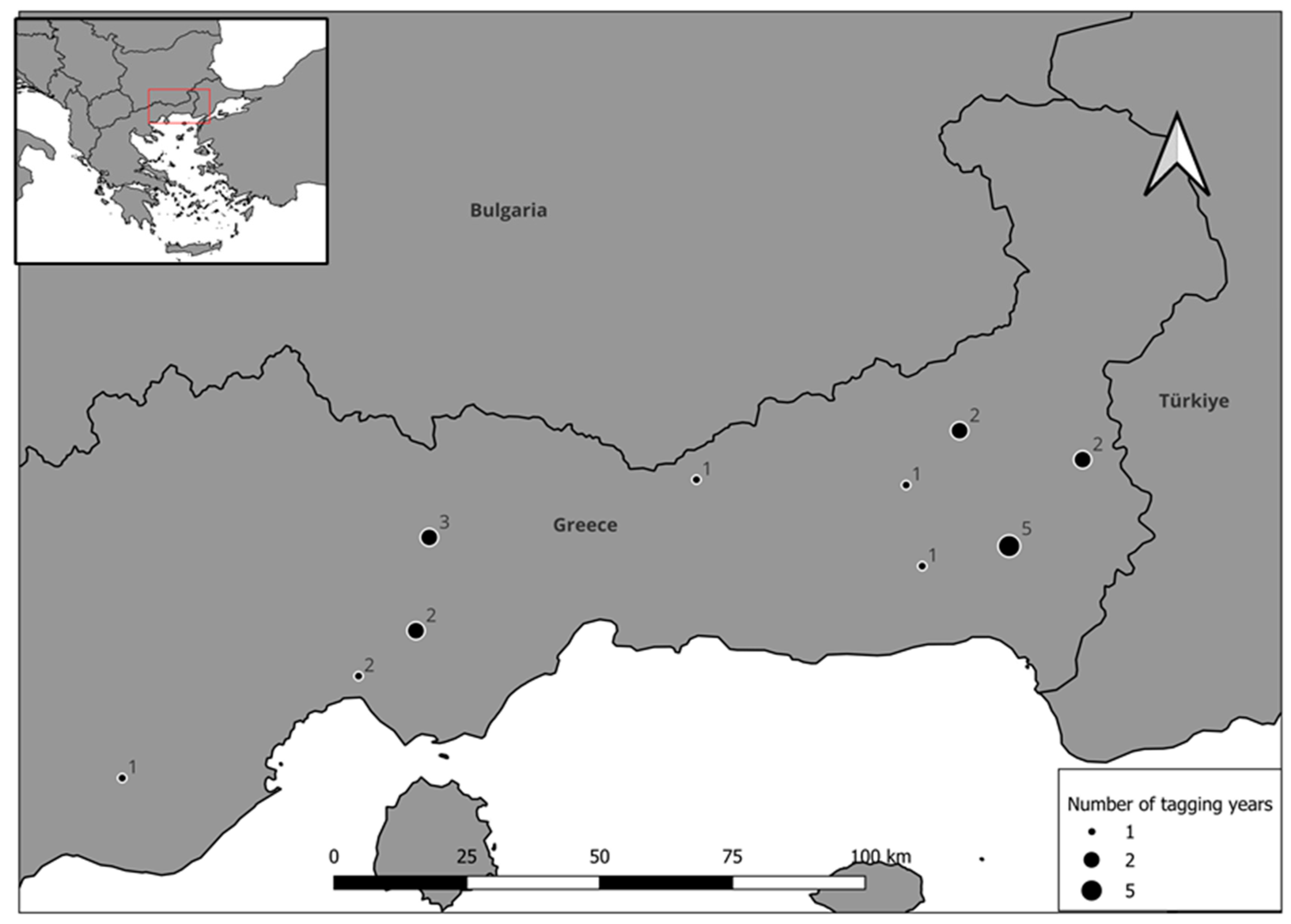
Figure 1. The Study area (inset is its position in SE Europe) with the natal territories of tagged chicks (2015–2023). Labels indicate number of tagged chicks in each territory.
Diversity 16 00580 g001
Figure 2. (a) Determination of dispersal onset for Eagle M000422 (left). Solid and dashed horizontal lines determine the 6 and 9 km from natal nest thresholds, respectively. The red vertical line marks the dispersal onset. (b) Overall distribution of dispersal onsets (n = 18) for the population (right), box contains interquartile range, thick black line indicates the median and the whiskers the min–max range.
Diversity 16 00580 g002
Figure 3. Smoothed mean and standard errors of roost site distancing to nest at the first 310 days post dispersal onset (n d0 = 14, n d310 = 10 individuals).
Diversity 16 00580 g003
Figure 4. Distributions, from left to right, of number of temporary settlement (TS) events per individual eagle (n = 14), n events per month of tracking and proportion of total tracking time spent in temporary settlement. Thick black lines indicate the median, boxes encompass the interquartile range and whiskers the min–max range.
Diversity 16 00580 g004
Figure 5. Minimum Convex Polygons of Temporary Settlement events across the study area. Red boundaries indicate areas of individual birds used in TSA conditional regression modeling.
Diversity 16 00580 g005
Figure 6. GET and GETc (bottom right) model variable classes’ use (light bars) and availability (dark bars), raw proportions. Significant relationships (proportions of availability not overlapping with use confidence intervals) are indicated by asterisks above each class.
Diversity 16 00580 g006
Figure 7. Cumulative fit performance (proportion of data belonging to each class or lower, highest preference is 10) of the GET model (black lines) and the GETc model incorporating the tree cover density (grey lines). Solid lines are the 75% training datasets, dotted lines are the 25% testing dataset and dot–dash lines the independent testing dataset.
Diversity 16 00580 g007
Figure 8. Preference Class prediction (highest preference is 10) for the GETc model for northern Greece and Bulgaria.
Diversity 16 00580 g008
Figure 9. Average preference class scores for the GET model (GET, (left)) and the GETc model (right) across the TSA polygon types, MCP, 95% MKDE isopleth (Range) and MKDE core area (Core).
Diversity 16 00580 g009
Table 1. Mean values of Minimum Convex Polygon (MCP) and Movement-Based Kernel Areas (MKDE) of Temporary Settlement Events (TSEs) by season (n = 117). Standard deviation in parentheses.
TS Polygon TypeSeasonMean Area (km2)
95% MCPWinter84.89 ± 23.58
Summer82.65 ± 23.41
95% MKDEWinter24.62 ± 13.62
Summer18.28 ± 11.53
Core Area MKDEWinter6.44 ± 10.19
Summer5.29 ± 8.82
Table 2. Class frequency and area covered by preference classes of the Suitability models across N. Greece and Bulgaria.
GET ModelGETc Model
ClassPercentageArea (km2)PercentageArea (km2)
15.686595.68659
214.322,06514.322,065
318.328,08418.328,084
413.020,06013.020,060
59.815,0159.915,159
68.813,4798.713,420
78.412,9008.412,857
87.812,0497.611,632
97.211,1157.611,720
106.810,4226.610,193
Table 3. Conditional logistic regression model selection process, models in bold indicate the selected model for the number of fitted parameters, χ2 tests refer to comparisons between the model and the selected model in the previous step. Averages of slope (degrees), % covered by open land (cover < 50%) and the division index between covers < 50 and >50%.
VariablesAICcConcordanceZpχ2χ2 p
Slope43.010.8532.5<0.003
Division43.320.8532.2<0.02
% Open61.40.6614.11<0.001
Slope + Open35.60.8642.09<0.00019.6<0.002
Slope + Division35.10.9142.6<0.000110.1<0.002
Slope + Open + Division32.50.9147.5<0.00014.8<0.03
Table 4. Conditional logistic regression model outputs (106 polygons in 53 strata).
Model Model TermCoefficientOddsLower CIUpper CIZp
Slope + OpenSlope1.614.992.0212.353.48<0.0001
Open0.231.261.061.502.59<0.001
Slope + DivisionSlope1.614.991.296.902.570.01
Division0.191.210.9991.471.950.051
Slope + Open + Division Slope1.243.241.349.072.560.01
Open0.181.190.9991.41.950.051
Division0.131.140.971.331.560.12
Disclaimer/Publisher’s Note: The statements, opinions and data contained in all publications are solely those of the individual author(s) and contributor(s) and not of MDPI and/or the editor(s). MDPI and/or the editor(s) disclaim responsibility for any injury to people or property resulting from any ideas, methods, instructions or products referred to in the content.