Article

Distribution of Aquatic Macrophytes in the Littoral of Lake Bohinj (Slovenia)

Department of Biology, Biotechnical Faculty, University of Ljubljana, Jamnikarjeva 101, 1000 Ljubljana, Slovenia
*
Author to whom correspondence should be addressed.
Diversity 2023, 15(11), 1115; https://doi.org/10.3390/d15111115
Submission received: 22 August 2023 / Revised: 13 October 2023 / Accepted: 24 October 2023 / Published: 26 October 2023
(This article belongs to the Special Issue Aquatic Plant Diversity, Conservation, and Restoration)

Abstract

:
In alpine Lake Bohinj, which is an LTER site and a part of the national park, the occurrence and depth distribution of submerged and emerged aquatic macrophytes were analyzed. Nine submerged and one emergent macrophyte taxa were found in the lake: Myriophyllum spicatum, Chara virgata, Chara aspera, Potamogeton lucens, Potamogeton alpinus, Potamogeton crispus, Potamogeton perfoliatus, Potamogeton pusillus, Ranunculus circinatus with the synonym Batrachium foeniculaceum and the emergent species Phragmites australis. The depth of the vegetation zones was measured using a depth meter and their coordinates were recorded using a GNSS antenna with RTK receiver. These data were used along with a DEM of lake depths to accurately map the potential zone of macrophyte growth, which was based on the depths of macrophyte distribution. The potential zone of macrophyte growth consisted of 28 different transects and covered 240.14 ha of the lake. The macrophytes covered 5.55 ha. The most common and abundant species was M. spicatum. A significant difference in macrophyte cover was found between the south and north shores of the lake, with the south shore having more patches with a larger total area. A clear difference in macrophyte cover was also noted between the main inflow and outflow of the lake. The presence of macrophytes and their diversity varied in different parts of the lake due to differences in slope, depth and type of substrates.

Graphical Abstract

1. Introduction

Macrophytes are an important structural and functional component of the aquatic ecosystem, reflecting its spatial, temporal, physical, chemical and biotic characteristics [1]. A combination of various abiotic and biotic factors, such as light intensity, water depth, substrate characteristics, nutrient availability, competition and herbivory, often influence the distribution and abundance of macrophytes [2]. Macrophytes can grow where certain species-specific ecological conditions are met and thus reflect the physical and chemical conditions and biological characteristics of an ecosystem [3]. The presence of species and the range of their abundance provide qualitative information about limiting factors responsible for species distribution [4,5]. This group includes various vascular plants, ferns, mosses and certain macroalgae [6]. Vascular plants have higher light requirements and are found in shallower parts of the littoral, while mosses and algae have a lower compensation point and can inhabit greater depths [7]. Aquatic environments require certain adaptations for life in water [6]. The general adaptation typical of most macrophytes to an aquatic environment is thin and often dissected leaves that facilitate gas exchange. The leaves are characterized by the presence of chloroplasts in the epidermis, which is also an adaptation to low light conditions and is unusual for terrestrial plants [5]. On the other hand, the proportion of vascular and mechanical tissues is reduced in submersed plants. An important characteristic of macrophytes is the aerenchyma (air spaces), which allows the transport of gases from the leaves to the roots (O2) and from the roots to the leaves (CH4 and CO2).
It is not surprising that macrophytes have been shown to be sensitive to water quality or its sudden change [8]. Therefore, macrophytes are widely used to determine the ecological status of lakes [9]. Human activities have long exerted pressures on aquatic ecosystems, changing the local chemical and physical properties of water, to which macrophytes may respond strongly. Anthropogenic pressures include the direct management of water bodies, as well as land use or activities in the catchment [10], notably changing nutrient availability and consequently macrophyte assemblage.
Macrophyte surveying in lakes usually consists of the use of a bathyscope for underwater viewing and the use of tools such as rakes, which are dragged across the bottom to collect macrophyte samples [11,12]. Preselected strips of certain lengths and widths are selected along the shoreline, from which boat-based transect surveys are then conducted [13,14]. Additionally, bathymetric data can be used to achieve higher precision in area calculations for plant communities [15]. High-precision mapping can also be achieved by using medium- to high-resolution satellite imagery and imagery from unmanned aerial vehicles in conjunction with machine learning algorithms [16,17,18]. Boat-based transect surveys, along with the use of RTK-GPS technology, can also be used for high-precision macrophyte mapping.
In this study, we recorded the submerged macrophytes in the entire littoral zone of the Lake Bohinj, with special regard to species identity, cover and environmental characteristics such as substrate type, bottom inclination and water depth, which create different site conditions or even inhibit growth. Macrophyte studies at Lake Bohinj have so far focused mainly on a few sampling plots and transects along the shoreline, and detailed mapping of the entire littoral has not yet been conducted [19,20]. Lake Bohinj is located in the nature-protected area of Triglav National Park. Moreover, the studied lake is a Long Term Ecological Research Network (LTER) site, meaning that Lake Bohinj and its conditions are of great national and international importance. The considerable human pressure during the summer in Lake Bohinj requires quantitative research of both site conditions and human impact (crowds of tourists and visitors in bathing areas and elsewhere along the lakeshores, roads, parking lots and accommodations) on the presence and cover of macrophytes.
Based on differences in terrain and catchment use, we hypothesized that (1) the macrophyte cover will be higher on the gently sloping bottom on the south shore of the lake than on the steeply sloping north shore; (2) the shaded parts of the littoral will have lower macrophyte cover; (3) the macrophyte cover will be lower near the inflow than near the outflow of the lake.

2. Materials and Methods
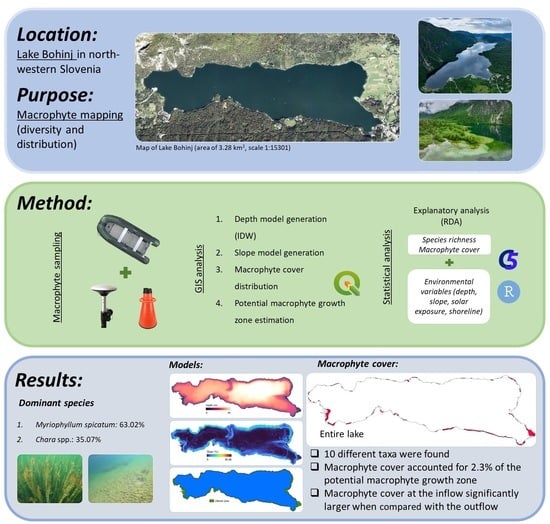
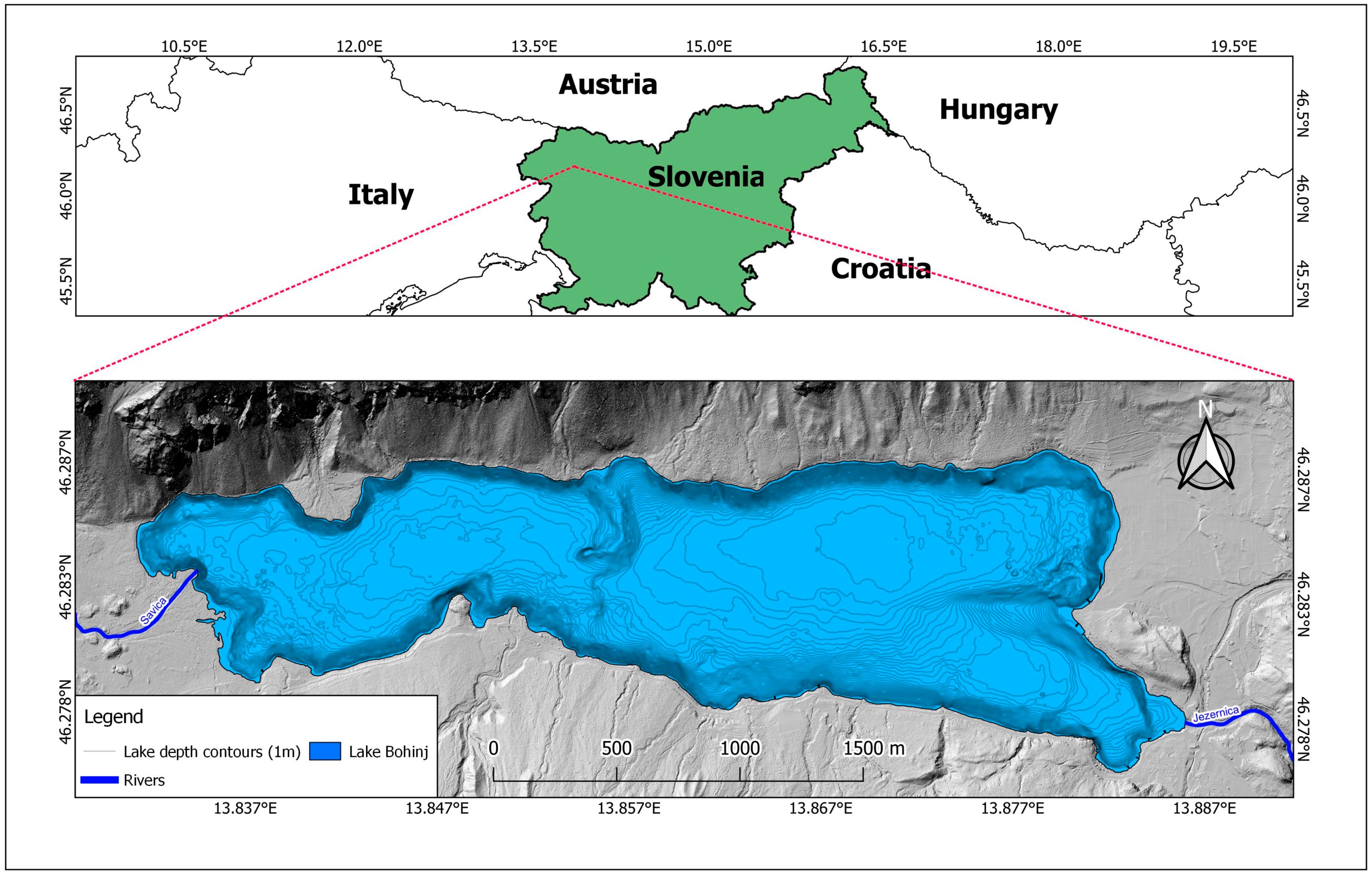
2.1. Study Site

Lake Bohinj is Slovenia’s largest natural permanent lake, with an area of 3.28 km2 and an average depth of 28 m (Figure 1). It reaches its maximum depth of 45 m in Fužina Bay in the NE part of the lake. The deep basin of the lake is the result of glacial action in the past. The low residence time of the water in the lake (3–4 months) is influenced by the considerably high throughflow generated by the inflowing Savica River in the west and the main outflow, the Jezernica River in the east. On the northern side of the lake, there are steep slopes (Mount Pršivec) with numerous scree fields reaching into the lake. The southern shore of the lake is flatter. Before the European Water Framework Directive was implemented, Lake Bohinj was classified as oligotrophic according to the Organisation for Economic Cooperation and Development criteria.

2.2. Water Quality Parameters and Environmental Conditions

The water quality parameters and environmental conditions were acquired from the Slovenian Environment Agency (ARSO). The water temperature, pH, electrical conductivity and oxygen content were measured at a depth interval of 1 m on 16.06.2022. Water samples for the total nitrogen and total phosphorus content of the water column were also taken on 16 June 2022. The samples were measured in a chemical analysis laboratory accredited by the Slovenian Accreditation Authority. The water analysis was performed using the standard methods for total nitrogen (SIST EN ISO 12260) and total phosphorus (SIST EN ISO 6878). All of the chemical analyses were validated and they also underwent interlaboratory testing. The water transparency was measured as Secchi depth.

2.3. Sampling of Macrophytes
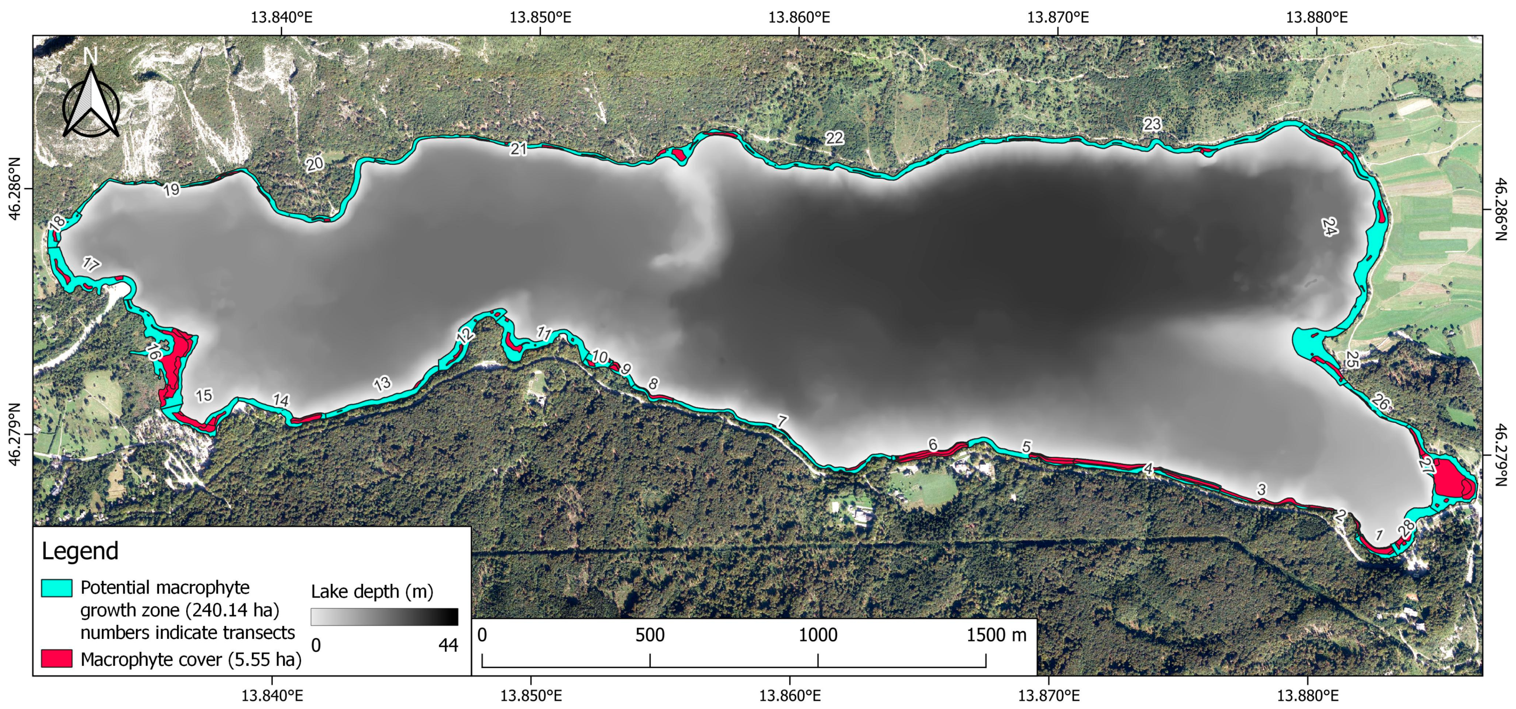
The presence, cover and distribution of macrophytes were assessed from a boat along the entire shoreline of the lake. Sampling and surveying were conducted in 6–10 June 2022 under sunny weather conditions that allowed optimal visibility. Different species of macrophytes were identified using a bathyscope. Macrophytes were also sampled using a telescopic rod with hooks and a rake with hooks.
The littoral was divided into 28 transects based on the presence and distribution of macrophytes and the change in riparian vegetation. For each transect, the slope and substrate types of the littoral, the vegetation type of the riparian zone and the presence and distribution of the macrophyte patches were recorded. Additionally, certain transects, mainly on the northern shore, contained tall trees in the riparian zone with canopies extending toward the center of the lake, shading the shallow parts of the littoral. These transects were classified as partly shaded while the transects absent from this phenomenon were classified as fully sunlit.
In each patch, the cover of all macrophytes was estimated. We recorded two different species of stonewort. However, we could not efficiently differentiate between them during the surveying of specific patches. Therefore, for the purpose of GIS and the statistical analyses of the macrophyte patches, the two species were characterized as Chara spp. The depth of each macrophyte patch was measured using a depth meter (Speedtech Instruments: Unionville, VA, USA) at their end points (minimum and maximum depths). These points were also recorded using a GNSS antenna with an RTK receiver (Ardusimple: Andorra la Vella, Andorra) to achieve centimeter-level accuracy, resulting in 4 points per macrophyte patch. These points were later used to approximately map the entirety of the Lake Bohinj macrophyte distribution in GIS.

2.4. GIS Analysis

To estimate the extent of the potential macrophyte growth zone of the lake and approximately map the distribution and cover of the macrophytes, we used a generated digital elevation model (DEM) of the lake depth. The DEM was generated by applying inverse distance weighting interpolation (IDW) onto the contour lines created by Harpha Sea from its bathymetric survey of the lake conducted in 2016 [21]. The created DEM layer was then used to calculate the slope of the lake basin (Figure 2). After generating the desired raster layers, we then imported the points that marked macrophyte patches at their maximum and minimum depths. The depth information of the macrophyte patches in combination with the DEM layer allowed us to create a polygon vector layer that accurately depicted the macrophyte distribution. The potential macrophyte growth zone was estimated from the edge of the lake basin to the maximal detected depth of the macrophytes per transect. The last step was to apply zonal statistics to calculate the average, standard deviation, minimal and maximal values of depth and slope of the potential macrophyte growth zone per transect and per macrophyte patch. We also calculated the area of the entire potential macrophyte growth zone and macrophyte patches. The described procedure was carried out in QGIS version 3.22.9 (the Open Source Geospatial Foundation: Beaverton, OR, USA).

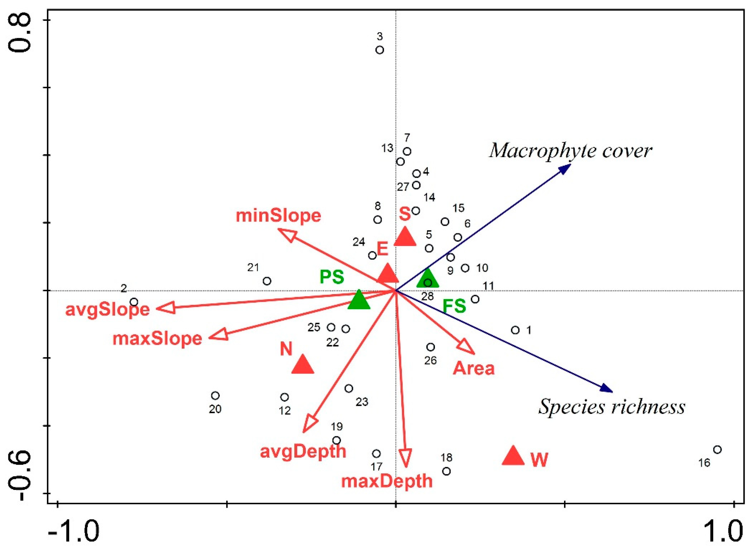
2.5. Statistical Analysis

To detect differences in macrophyte cover between the northern and southern shore, as well as differences between fully sunlit and partly shaded parts of the littoral, we used Welch’s two-sample t-test. The normality of the data and homogeneity of variance were tested beforehand. These tests were performed using the RStudio software: 2022.07.1 Build 554 (RStudio PBS: Boston, MA, USA). A redundancy analysis (RDA) was used for the explanatory data analysis to explain the variability in species richness and macrophyte cover with depth, slope, shading of shallow littoral and shoreline variables. Since our data were not compositional, a detrended correspondence analysis (DCA) was not used beforehand. A forward selection of explanatory parameters was applied using Monte Carlo tests with 499 permutations to avoid collinearity. RDA was performed using the Canoco 5 software (Microcomputer Power, Ithaca, NY, USA).

3. Results

3.1. Water Quality Parameters

Basic parameters, such as water temperature and oxygen concentration, change considerably with depth, so we provided the data for 1 m and for 10 m depth to cover most of the potentially vegetated zone of the littoral (Table 1). The water temperature at a depth of 10 m was noticeably lower compared to the water temperature at 1 m. The oxygen concentration, pH, and electrical conductivity were similar at both depths. The measurements of nutrients, namely total nitrogen (TN) and total phosphorus (TP), were available as average values for the entire photic zone of the lake. The average content of TN was 1.59 mg/L, while TP was below 0.015 mg/L. The water transparency was measured at 9.2 m, resulting in the compensation or photic zone reaching approximately 18.4 m in depth. The 20-year average water transparency from the 1996–2016 period is reported at 9.22 m [19].

3.2. Macrophyte Species Composition and Distribution

In the entire littoral zone of Lake Bohinj, 10 macrophyte taxa were found (Table 2). Eurasian watermilfoil (Myriophyllum spicatum) and two species of stonewort (Chara aspera and Chara virgata, from now considered as Chara spp.) comprised most of the macrophyte cover in Lake Bohinj. Eurasian watermilfoil was the most common species, making up 63% of the macrophyte cover. Patches containing Chara spp. covered a total of 35.1% of the macrophyte cover. Common reed (Phragmites australis) was the third most common species inhabiting the littoral zone. Three different species of pondweeds, namely, alpine pondweed (Potamogeton alpinus), curly-leaf pondweed (Potamogeton crispus) and clasping-leaved pondweed (Potamogeton perfoliatus), were also found in smaller patches, each covering <1% of the entire macrophyte cover. Fan-leaved water crowfoot with scientific name Ranunculus circinatus Sibth. and the synonym Batrachium foeniculaceum (Gilibert) Kreczetowicz was found in a single small patch and covered <1% of the entire macrophyte cover. Additionally, small pondweed (Potamogeton pusillus) and shining pondweed (Potamogeton lucens) were also recorded; however, due to their low abundance (less than 5 specimens), they were not considered patch-forming. The maximum depth for Chara spp. was recorded at 12.99 m, which is nearly 3 m deeper than M. spicatum. In contrast, the upper limit of the slope was higher for M. spicatum compared to Chara spp. The average recorded slope inclination values were around 20% for both species. Common reed was recorded up to 1.14 m of depth with an average slope of 2.8%. Potamogeton alpinus, the most common of the pondweeds, was recorded at greater depths than the P. crispus and P. perfoliatus. The species covering the smallest total area—0.32 m2—was R. circinatus/B. foeniculaceum.
The potential macrophyte growth zone of Lake Bohinj covered a total of 240.14 ha and included 28 different transects. The macrophyte patches covered a significantly smaller area, making up a total of 5.55 ha (Figure 3). The southern shore was divided into 16 transects, indicating greater heterogeneity in macrophyte distribution and differences in the riparian zone conditions (Table S1). Transects 1, 5 and 15 included three different taxa, M. spicatum, Chara spp. and P. alpinus or P. perfoliatus, while other southern transects included one or two taxa, mainly Chara spp. or M. spicatum. The potential macrophyte growth zone along the southern shore covered a total area of 87.1 ha. The western shoreline was divided into three different transects (16–18). In the 16th and 18th transects, we recorded four different taxa, making them the most species-rich. The 16th transect contained Chara spp., M. spicatum, P. australis and P. crispus. The 18th transect contained Chara spp., M. spicatum, P. perfoliatus and R. circinatus/B. foeniculaceum. The potential macrophyte growth zone along the western shore covered a total area of 39.7 ha. The north shore was divided into five transects only, containing two or one taxa. The potential macrophyte growth zone along the northern shore covered a total area of 54.7 ha. The much shorter eastern shore was divided into four transects containing one or two taxa per transect. The potential macrophyte growth zone along the eastern shore covered a total area of 58.6 ha.
A comparison between the southern and the northern shore proved to be statistically significant regarding macrophyte cover (Table 3). The transects along the southern shoreline had an average macrophyte cover of 2.56% of the potential macrophyte growth zone per transect which was significantly higher than the northern shoreline (0.97%). Comparing fully sunlit transects with partly shaded transects was not statistically significant, with the fully sunlit transects having an average macrophyte cover of 2.58% and the partially shaded transects having an average macrophyte cover of 1.84% (Table 3).
On the western shoreline at the main inflow from the Savica River, we recorded four patches of M. spicatum for a total area of 593.47 m2. In contrast, on the eastern shoreline near the only outflow, the Jezernica River, we recorded five much larger macrophyte patches (Figure 4). Two larger patches contained M. spicatum, while three smaller patches included Chara spp. The total macrophyte cover at the outflow was significantly higher at 10,533.45 m2 with M. spicatum covering a greater area than Chara spp.

3.3. Relationship between Environmental Variables, Species Richness and Macrophyte Cover

The results of the RDA showed that environmental parameters explained a total of 45.5% of the variance in species richness and macrophyte cover (Table 4). The variables regarding the slope characteristics explained a total of 19.2% of the variance, with the average slope accounting for 16.9% of the variance. The depth variables explained a total of 11.5% of the variance, with the average depth of the potential macrophyte growth zone explaining 6.4% and the maximal depth of the potential macrophyte growth zone explaining 5.1% of the variance. Fully sunlit and partly shaded transects only accounted for 1.4% of the explained variance. Classifying transects based on the shoreline explained a total of 13.4% of the variance.
The RDA ordinate plot shows the relationship between species richness and macrophyte cover with the environmental variables (Figure 5). A negative relationship can be observed between species richness and the minimum slope of the potential macrophyte growth zone as the vectors are pointed in opposite directions. A positive relationship can be observed between species richness and the area of the potential macrophyte growth zone per transect. On the other hand, a negative relationship can be observed between macrophyte cover and the average slope, maximum slope and average depth of the potential macrophyte growth zone, indicating that the steeper the slope and greater the depth, the lower the macrophyte cover. The western shoreline was the most species-rich and distinctly different from the other parts of the shore.

4. Discussion

4.1. Local Catchment Area

The catchment characteristics influence the physical and chemical properties of the lake [22], such as pH, substrate, nutrient content, content of toxic substances and the amount of dissolved and suspended organic and inorganic particles. A part of the catchment area adjacent to the lake, also called the local catchment area, influences the littoral directly also via other environmental characteristics, such as the shoreline topography [23], of which the most important feature is the steepness of the shore and the hillside behind it. This also influences the substrate texture; the vegetation height on the shore shading the upper littoral [24]; the land cover [25], which also influences the amount and quality of run-off, etc. Human activities and interventions in the catchment areas affect the status of the lake [26]. Negative anthropogenic impacts include increased nutrient and toxin inputs, reduction in the natural buffering and self-purifying capacity of the system and physical alteration of the landscape (deforestation).
On the northern shore, the terrain is very steep, rising rapidly several hundred meters above the lake. In the western part of the north shore, there are screes where natural disturbances are frequent, as they continue underwater in some places where the substrate particles are very large (rocks and boulders) (Table S2). The substrate is unstable there and the steep slope is the main limiting factor for macrophyte growth [27] (Table 2). Moreover, the shallower parts of the littoral are shaded by trees, spreading their canopies above the water surface, preventing direct sunlight from reaching the bottom. Due to the morphology of the terrain and inaccessibility to humans, human impacts are minimal there, except for the occasional cutting of trees, which is accompanied by increased soil erosion and run-off into the lake. Light intensity, water depth and the degree of eutrophication are very important for the growth of submerged macrophytes [28].
On the eastern shore is the largest settlement by the lake, called Ribčev Laz. The settlement has a sewage system and the water from the settlement does not drain into the lake. The northern part of the eastern shore is a frontal moraine with agricultural land-use. Most of it is intensively cultivated grassland, fertilized almost to the lake shore. As the ground is very permeable to water, this results in additional nutrient input to the lake. The most critical area is in Fužina Bay, where the water retention time is high. There is an official bathing area where bathers stir up the sediment, releasing additional nutrients (Table S2). The biotic communities in the substrate are affected by bathers walking around on the substrate, picking off macrophytes and turning over stones [20].
In the southern part, the road along the lake shore is the most impactful and potentially threatening factor. Toxic substances and salt seep into the lake from the road. Moreover, the road allows the presence of numerous visitors who often disturb the littoral zone. On the other hand, the road close to the lake has also contributed to the removal of many large trees that used to shade the upper parts of the littoral.
On the western shore of the lake is the tourist settlement of Ukanc, with a campsite and several apartment houses (Table S2). The buildings on the left bank of the Savica River are not connected to the sewage network, so the wastewater enters the groundwater and then slowly flows into the lake. There are also reedbeds that form a buffer zone between the lake and the land. The common reed is among the macrophytes that most efficiently absorb nitrates and other nutrients from the water [29].
The studied lake can still be classified as an oligotrophic lake, but the situation may deteriorate for the reasons mentioned above. The short residence time of the water in Lake Bohinj mitigates the inflow of nutrients from the catchment and prevents the development of eutrophication processes. Differences in slope and land use around the lake resulted in different substrate types and their distributions along the shore, which were expected.

4.2. Macrophytes—Species Found

We confirmed the presence of 10 macrophyte taxa: Myriophyllum spicatum, Chara aspera, Chara virgata, Potamogeton lucens, Potamogeton alpinus, Potamogeton crispus, Potamogeton perfoliatus, Potamogeton pusillus, Ranunculus circinatus Sibth. synonym Batrachium foeniculaceum (Gilibert) Kreczetowicz and Phragmites australis (Table 2). The species composition is similar to that of a survey conducted between 1996 and 2016 by Germ et al. [19], where they additionally found Chara rudis and Ranunculus trichophyllus.
Myriophyllum spicatum was the most frequently occurring and abundant macrophyte in Lake Bohinj, present in most of the surveyed sections and having the highest cover among the macrophytes (Table 1). The high abundance of M. spicatum shows a clear shift in macrophyte structure, since in the past, the abundance of the genus Chara was higher than that of M. spicatum [27]. This shift may indicate also the trend toward the mesotrophic status of the lake, which could be also confirmed by the relatively high content of TN (1.26 mg/L). This species thrives in stagnant and slow-flowing waters [30]. It has a wide ecological amplitude, which also makes it the most common macrophyte species in Slovenian watercourses [31]. M. spicatum can thrive at depths from 1 to 10 m [32], but its optimal depth, where it is most abundant, is from 1 to 4 m [33]. Since it spreads quickly and efficiently through its vegetative parts (fragmentation), this macrophyte has the potential to outcompete and displace other vegetation due to its high competitive ability. After M. spicatum reaches high biomass, it can also alter the physical and chemical characteristics of the waterbody and negatively affect other aquatic organisms [34].
Species of the genus Chara occurred together with Potamogeton perfoliatus, but in smaller patches and with a lower percentage of cover (Table S1). Due to the higher ratio of photosynthetic tissue to non-photosynthetic tissue, they can reach greater depths, sometimes up to 12 m in New Zealand lakes [35]. In Lake Bohinj, their presence was confirmed to a depth of 12.99 m, which was also the greatest depth reached by the macrophytes recorded here. The water transparency was not an important factor influencing the distribution of macrophytes. Some Chara species are an indicator of good ecological quality [36], such as C. aspera, one of the two Chara species found in the conducted survey.
We also found five species from the genus Potamogeton (Table 1). P. alpinus has a higher cover on the south side of the lake. P. lucens grows in the same area as P. crispus in Lake Bohinj. Preston [37] states that this species is characteristic of water bodies at lower altitudes up to 380 m above sea level (a. s. l.) in Great Britain (Lake Bohinj is at 526 m a. s. l.). Both species were found only on the western shore.
We found 10 macrophyte taxa in Lake Bohinj, which is similar to the year 2020 [38]. In both years, the taxa M. spicatum, P. perfoliatus, P. lucens, P. pusillus and P. alpinus were present in Lake Bohinj. The similar number of taxa and depth of macrophyte growth in 2020 and 2022 indicate that the macrophyte growth conditions are stable. Most of the species found are on the Red List [39]. This is another reason why the lake ecosystem needs to be protected to prevent deterioration. These submerged macrophytes are also important indicators of the ecological status of Lake Bohinj.

4.3. Macrophyte Distribution and Cover

We recorded higher macrophyte cover on the gently sloping bottom in the littoral of the south shore of the lake than in the north shore, with an average cover of 2.56% of the potential macrophyte growth zone on the southern side and 0.97% on the northern side. The total cover of all macrophyte patches recorded was approximately 5.55 ha, which is less than 2% of the area of the potential macrophyte growth zone (Figure 1). Macrophytes may not be as important as phytoplankton or phytobenthos for the gross primary production of Lake Bohinj, but are very important as a habitat for macroinvertebrates. During fieldwork with students, a significantly higher abundance of benthic invertebrates was recorded in macrophyte stands than in unvegetated parts of the littoral, which was also discovered by James et al. [23]. However, the north shore was steeper and less suitable for anchoring macrophytes. The failure to anchor macrophytes could also be associated with the soft sediments [40]. The southern shore is dominated by fine substrate such as sand and silt, while the substrate on the northern shore is coarse, consisting mainly of pebbles and stones (Table S2). At the same time, due to the lower inclination of the slope along most of the southern shore, the aquatic vegetation extends farther away from the tall forest vegetation on the coast and deeper, as can be seen from the maximum depths. In contrast, the northern side has steeper and narrower shorelines and consequently vegetated strips that end abruptly. The run-off of nutrients and suspended solids is more intense on the north side due to the steep slope and less developed vegetation. As the depth increases, the light availability for photosynthesis may decrease [41]. The forest vegetation on certain parts of the north shore of the lake also has an important influence on macrophyte growth by shading the littoral [24] and reducing light availability. The trees on the bank often have the lushest canopies due to better water and light availability on the edge of the lake compared to the sites few meters away. A similar trend is observed on the south side for a comparable shoreline type where tree canopies extend over the water and provide shade in the shallow littoral. Thus, in the north, the conditions are less favorable for macrophytes, which is consequently represented by a lower cover of vegetation.
M. spicatum was mostly found in the shallow littoral and did not reach greater depths due to its higher light requirements (Table 1). An increased water depth causes a light deficiency for submerged macrophytes [42]. In sites where the light intensity is too low, this macrophyte is replaced by Chara species (Table 2). It is important to note that species dominance can be reversed on the north shore, meaning species-specific depth zones are atypical where large trees with lush canopies extending over the water shade the shallowest part of the littoral and prevent light from reaching the substrate, which in turn inhibits the growth of M. spicatum. Therefore, in the shallower parts of the littoral, we see Chara species first and then M. spicatum, which finds better light conditions in the deeper parts, provided, of course, that it has a suitable substrate and slope to root.
Another significant difference is the macrophyte cover at the inflow of the lake, the River Savica, and at the outflow of the lake, where the cover at the outflow is significantly higher (Figure 4). The inflowing Savica River generates frequent disturbance and continuously deposits fluvial sediments that cover the bottom and macrophytes, hindering their growth and the substrate stability. In addition to the instability of the substrate, the bottom at the inflow is very steep (Figure 2), causing the inflowing colder water (6–7 °C) to sink rapidly into the hypolimnion, washing away the nutrients and FPOM. The constantly lower temperature at the inflow could also affect the difference since the temperatures at the outflow are significantly higher, receiving the warm epilimnion water reaching above 15 °C from early June to late August [43]. In addition, the hydromorphological conditions are different at the outflow. At the outflow, there is almost a flat bottom (Figure 2), reaching far from the shore. There, the outflowing warm water supplies the area with settling fine organic particles, which provide available nutrients for macrophytes, allowing for a fertile and stable substrate. Barko et al. [44] reported that temperature strongly influences the distribution of submerged freshwater macrophytes, which is also species-specific. Moreover, the optimal water temperature for submerged macrophytes is 28–32 °C [45].

5. Conclusions

The aquatic macrophyte cover is significantly higher on the southern shore than on the northern shore of Lake Bohinj due to differences in slope, substrate and littoral shading. We can confirm the first hypothesis. The substrate is of primary importance to the rooting and persistence of macrophytes, providing a substrate for them to adhere to and a reservoir for plant-available nutrients in the case of rooted vascular plants. The cover differed most between fine (sand and silt) and coarse substrate (pebbles, stones), which was the key difference in favorable conditions observed for macrophytes in all sections, regardless of the side of the lake. The shading alone has not caused a significant difference in macrophyte cover, so the second hypothesis cannot be confirmed. The differences in conditions are more complex as they also include the steepness of the slope and the texture of the substrate. Human impact is more evident on the southern shore. In the bathing areas, the upper edge of the aquatic vegetation is shifted deeper due to frequent disturbances such as trampling and the removal of macrophytes. The difference in the aquatic vegetation cover can also be observed at the inflow and outflow (Figure 4), which differ significantly according to a number of physical parameters. We can confirm the third hypothesis. The steep slope of the littoral and cold inflowing water, causing frequent disturbances, prevents macrophyte growth at the inflow. At the outflow, the substrate is stable, enriched with fine organic particles and consequently nutrients, allowing aquatic vegetation to thrive.
Mostly in the shallower part of the littoral, we recorded vascular plants such as Myriophyllum spicatum and various pondweeds. However, in the shaded parts of the littoral, we observed an inverse distribution of the vegetation zones. The first zone with Chara spp. was followed by a zone with M. spicatum. This phenomenon is more common on the north side of the lake due to the shoreline topography but also occurs on the south side, where it is less common, occurring only in isolated shaded sections. The increasing proportion of M. spicatum cover, which has overtaken the proportion of Chara spp. that used to be dominant a few decades ago, indicates the shift toward the mesotrophic status of the lake, which can be supported by the relatively high concentration of TN.
The performed method of sampling individual species of aquatic macrophytes, estimating their cover and the depth to which they extend, along with recording the exact coordinates, will enable accurate detection of the aquatic vegetation distribution in the future and advanced monitoring of this LTER site.

Supplementary Materials

The following supporting information can be downloaded at https://www.mdpi.com/article/10.3390/d15111115/s1, Table S1: Environmental parameters of the littoral zone per transect along with number of species found and their macrophyte cover per transect, Table S2: Prevailing substrate per transect along with the most common riparian zone vegetation and nearby anthropogenic factors.

Author Contributions

Conceptualization, M.G., I.Z. and N.O.; methodology, M.G. and N.O.; validation, M.G. and I.Z.; formal analysis, N.O.; investigation, D.Č. and M.A.; data curation, N.O.; writing—original draft preparation, D.Č. and M.A.; writing—review and editing, I.Z., M.G. and N.O.; visualization, N.O.; supervision, I.Z.; funding acquisition, I.Z., M.G. and N.O. All authors have read and agreed to the published version of the manuscript.

Funding

This research was funded by the Slovenian Research Agency, within the core research funding Nr. P1-0212, “Biology of Plants”, by the Young Researcher grant Nr. 5585 and by the Commission of the European Communities through the project Life Watch and the infrastructure project eLTER.

Informed Consent Statement

Not applicable.

Data Availability Statement

Data will be provided upon reasonable request.

Acknowledgments

The authors would like to thank the Municipality of Bohinj for providing us with the depth contour lines created by Harpha Sea, which allowed us to analyze our data more accurately in QGIS.

Conflicts of Interest

The authors declare no conflict of interest.

References

  1. Wetzel, R.G. Limnology Lake and Reservoir Ecosystems; Academic Press: San Diego, CA, USA, 2001; ISBN 9780127447605. [Google Scholar]
  2. Scheffer, M.; Hosper, S.H.; Meijer, M.-L.; Moss, B.; Jeppesen, E. Alternative Equilibria in Shallow Lakes. Trends Ecol. Evol. 1993, 8, 275–279. [Google Scholar] [CrossRef]
  3. Pinero-Rodríguez, M.J.; Fernández-Zamudio, R.; Arribas, R.; Gomez-Mestre, I.; Díaz-Paniagua, C. The Invasive Aquatic Fern Azolla filiculoides Negatively Impacts Water Quality, Aquatic Vegetation and Amphibian Larvae in Mediterranean Environments. Biol. Invasions 2021, 23, 755–769. [Google Scholar] [CrossRef]
  4. Ehrlén, J.; Morris, W.F. Predicting Changes in the Distribution and Abundance of Species under Environmental Change. Ecol. Lett. 2015, 18, 303–314. [Google Scholar] [CrossRef]
  5. Howard, C.; Stephens, P.A.; Pearce-Higgins, J.W.; Gregory, R.D.; Willis, S.G. Improving Species Distribution Models: The Value of Data on Abundance. Methods Ecol. Evol. 2014, 5, 506–513. [Google Scholar] [CrossRef]
  6. Bowden, W.B.; Glime, J.M.; Riis, T. Macrophytes and Bryophytes. In Methods in Stream Ecology: Volume 1: Ecosystem Structure; Elsevier: Amsterdam, The Netherlands, 2017; pp. 243–271. [Google Scholar]
  7. Madsen, T.V.; Sand-Jensen, K. Photosynthetic Carbon Assimilation in Aquatic Macrophytes. Aquat. Bot. 1991, 41, 5–40. [Google Scholar] [CrossRef]
  8. Kolada, A. The Use of Aquatic Vegetation in Lake Assessment: Testing the Sensitivity of Macrophyte Metrics to Anthropogenic Pressures and Water Quality. Hydrobiologia 2010, 656, 133–147. [Google Scholar] [CrossRef]
  9. Søndergaard, M.; Phillips, G.; Hellsten, S.; Kolada, A.; Ecke, F.; Mäemets, H.; Mjelde, M.; Azzella, M.M.; Oggioni, A. Maximum Growing Depth of Submerged Macrophytes in European Lakes. Hydrobiologia 2013, 704, 165–177. [Google Scholar] [CrossRef]
  10. Grizzetti, B.; Pistocchi, A.; Liquete, C.; Udias, A.; Bouraoui, F.; van de Bund, W. Human Pressures and Ecological Status of European Rivers. Sci. Rep. 2017, 7, 205. [Google Scholar] [CrossRef] [PubMed]
  11. Kanninen, A.; Vallinkoski, V.-M.; Leka, J.; Marjomäki, T.J.; Hellsten, S.; Hämäläinen, H. A Comparison of Two Methods for Surveying Aquatic Macrophyte Communities in Boreal Lakes: Implications for Bioassessment. Aquat. Bot. 2013, 104, 88–100. [Google Scholar] [CrossRef]
  12. Mjelde, M.; Thrane, J.; Demars, B.O.L. High Aquatic Macrophyte Diversity in Norwegian Lakes North of the Arctic Circle. Freshw. Biol. 2023, 68, 509–522. [Google Scholar] [CrossRef]
  13. Dudley, B.; Dunbar, M.; Penning, E.; Kolada, A.; Hellsten, S.; Oggioni, A.; Bertrin, V.; Ecke, F.; Søndergaard, M. Measurements of Uncertainty in Macrophyte Metrics Used to Assess European Lake Water Quality. Hydrobiologia 2013, 704, 179–191. [Google Scholar] [CrossRef]
  14. Heino, J.; García Girón, J.; Hämäläinen, H.; Hellsten, S.; Ilmonen, J.; Karjalainen, J.; Mäkinen, T.; Nyholm, K.; Ropponen, J.; Takolander, A.; et al. Assessing the Conservation Priority of Freshwater Lake Sites Based on Taxonomic, Functional and Environmental Uniqueness. Divers. Distrib. 2022, 28, 1966–1978. [Google Scholar] [CrossRef]
  15. Ciecierska, H.; Kolada, A. ESMI: A Macrophyte Index for Assessing the Ecological Status of Lakes. Environ. Monit. Assess. 2014, 186, 5501–5517. [Google Scholar] [CrossRef] [PubMed]
  16. Niculescu, S.; Boissonnat, J.-B.; Lardeux, C.; Roberts, D.; Hanganu, J.; Billey, A.; Constantinescu, A.; Doroftei, M. Synergy of High-Resolution Radar and Optical Images Satellite for Identification and Mapping of Wetland Macrophytes on the Danube Delta. Remote Sens. 2020, 12, 2188. [Google Scholar] [CrossRef]
  17. Espel, D.; Courty, S.; Auda, Y.; Sheeren, D.; Elger, A. Submerged Macrophyte Assessment in Rivers: An Automatic Mapping Method Using Pléiades Imagery. Water Res. 2020, 186, 116353. [Google Scholar] [CrossRef]
  18. Novković, M.; Cvijanović, D.; Mesaroš, M.; Pavić, D.; Drešković, N.; Milošević, Đ.; Anđelković, A.; Damnjanović, B.; Radulović, S. Towards UAV Assisted Monitoring of Aquatic Vegetation Withing Large Rivers—The Middle Danube (Serbia). Carpathian J. Earth Environ. Sci. 2023, 18, 307–322. [Google Scholar] [CrossRef]
  19. Germ, M.; Remec-Rekar, Š.; Gaberščik, A. Weather Conditions and Chlorophyll Concentrations Determine Long-Term Macrophyte Community Dynamics of Lake Bohinj (Slovenia). Reg. Environ. Chang. 2019, 19, 339–348. [Google Scholar] [CrossRef]
  20. Germ, M.; Golob, A.; Zelnik, I.; Klink, A.; Polechońska, L. Contents of Metals in Sediments and Macrophytes Differed between the Locations in an Alpine Lake Revealing Human Impacts—A Case Study of Lake Bohinj (Slovenia). Water 2023, 15, 1254. [Google Scholar] [CrossRef]
  21. Harpha Sea. Batimetrična Izmera Bohinjskega Jezera; Harpha Sea, Ltd.: Koper, Slovenia, 2016. [Google Scholar]
  22. Kamenik, C.; Schmidt, R.; Kum, G.; Psenner, R. The Influence of Catchment Characteristics on the Water Chemistry of Mountain Lakes. Arct. Antarct. Alp. Res. 2001, 33, 404–409. [Google Scholar] [CrossRef]
  23. James, M.R.; Weatherhead, M.; Stanger, C.; Graynoth, E. Macroinvertebrate Distribution in the Littoral Zone of Lake Coleridge, South Island, New Zealand—Effects of Habitat Stability, Wind Exposure, and Macrophytes. N. Z. J. Mar. Freshwater Res. 1998, 32, 287–305. [Google Scholar] [CrossRef]
  24. Sender, J. The Effect of Riparian Forest Shade on the Structural Characteristics of Macrophytes in a Mid-Forest Lake. Appl. Ecol. Environ. Res. 2016, 14, 249–261. [Google Scholar] [CrossRef]
  25. Cheruvelil, K.S.; Soranno, P.A. Relationships between Lake Macrophyte Cover and Lake and Landscape Features. Aquat. Bot. 2008, 88, 219–227. [Google Scholar] [CrossRef]
  26. Van Geest, G.J.; Roozen, F.C.J.M.; Coops, H.; Roijackers, R.M.M.; Buijse, A.D.; Peeters, E.T.H.M.; Scheffer, M. Vegetation Abundance in Lowland Flood Plan Lakes Determined by Surface Area, Age and Connectivity. Freshw. Biol. 2003, 48, 440–454. [Google Scholar] [CrossRef]
  27. Urbanc-Bercic, O. Aquatic Vegetation in Two Pre-Alpine Lakes of Different Trophic Levels (Lake Bled and Lake Bohinj): Vegetation Development from the Aspect of Bioindication. Acta Bot. Gall. 1995, 142, 563–570. [Google Scholar] [CrossRef]
  28. Dong, B.; Zhou, Y.; Jeppesen, E.; Shi, K.; Qin, B. Response of Community Composition and Biomass of Submerged Macrophytes to Variation in Underwater Light, Wind and Trophic Status in a Large Eutrophic Shallow Lake. J. Environ. Sci. 2021, 103, 298–310. [Google Scholar] [CrossRef]
  29. Brisson, J.; Chazarenc, F. Maximizing Pollutant Removal in Constructed Wetlands: Should We Pay More Attention to Macrophyte Species Selection? Sci. Total Environ. 2009, 407, 3923–3930. [Google Scholar] [CrossRef]
  30. Martinčič, A.; Wraber, T.; Jogan, N.; Podobnik, A.; Turk, B.; Vreš, B.; Ravnik, V.; Frajman, B.; Strgulc Krajšek, S.; Trčak, B.; et al. Mala Flora Slovenije: Ključ za Določanje Praprotnic in Semenk; Tehniška založba Slovenije: Ljubljana, Slovenia, 2007. [Google Scholar]
  31. Zelnik, I.; Kuhar, U.; Holcar, M.; Germ, M.; Gaberščik, A. Distribution of Vascular Plant Communities in Slovenian Watercourses. Water 2021, 13, 1071. [Google Scholar] [CrossRef]
  32. Aiken, S.G.; Newroth, P.R.; Wile, I. The Biology of Canadian Weeds.: 34. Myriophyllum spicatum L. Can. J. Plant Sci. 1979, 59, 201–215. [Google Scholar] [CrossRef]
  33. Nichols, S.A.; Shaw, B.H. Ecological Life Histories of the Three Aquatic Nuisance Plants, Myriophyllum spicatum, Potamogeton crispus and Elodea canadensis. Hydrobiologia 1986, 131, 3–21. [Google Scholar] [CrossRef]
  34. Grace, J.B.; Wetzel, R.G. The Production Biology of Eurasian Watermilfoil (Myriphyllum spicatum L.): A Review. J. Aquat. Plant Manag. 1978, 16, 1–11. [Google Scholar]
  35. Schwarz, A.-M.; de Winton, M.; Hawes, I. Species-Specific Depth Zonation in New Zealand Charophytes as a Function of Light Availability. Aquat. Bot. 2002, 72, 209–217. [Google Scholar] [CrossRef]
  36. Beaune, D.; Sellier, Y.; Lambert, É.; Grandjean, F. The Use of Chara Spp. (Charales: Characeae) as a Bioindicator of Physico-Chemical Habitat Suitability for an Endangered Crayfish Austropotamobius pallipes in Lentic Waters. Aquat. Conserv. 2018, 28, 506–511. [Google Scholar] [CrossRef]
  37. Preston, C.D. Pondweeds of Great Britain and Ireland, 1st ed.; Botanical Society of Britain and Ireland: London, UK, 1995; Volume 8, p. 352. [Google Scholar]
  38. Germ, M.; Golob, A.; Zelnik, I.; Klink, A.; Polechońska, L. Diversity of Macrophytes and Differences in the Contents of Metals between Macrophyte Species in Alpine Lake Bohinj (Slovenia). In Tackling Present and Future Environmental Challenges of a European Riverscape; IAD Proceedings: Krems, Austria, 2023. [Google Scholar] [CrossRef]
  39. Wraber, T.; Skoberne, P.; Seliškar, A.; Vreš, B.; Babij, V.; Čarni, A.; Čušin, B.; Dakskobler, I.; Surina, B.; Šilc, U.; et al. Rdeči seznam praprotnic in semenk (Pteridophyta & Spermatophyta). In Odredba o Uvrstitvi Ogroženih Rastlinskih in Živalskih Vrst v Rdeče Sezname, Odredba o Uvrstitvi Ogroženih Rastlinskih in Živalskih Vrst v Rdeče Sezname; Ministry of Environment: Ljubljana, Slovenia, 2002; pp. 5–20. [Google Scholar]
  40. Schutten, J.; Dainty, J.; Davy, A.J. Root Anchorage and Its Significance for Submerged Plants in Shallow Lakes. J. Ecol. 2005, 93, 556–571. [Google Scholar] [CrossRef]
  41. Lacoul, P.; Freedman, B. Environmental Influences on Aquatic Plants in Freshwater Ecosystems. Environ. Rev. 2006, 14, 89–136. [Google Scholar] [CrossRef]
  42. Bornette, G.; Puijalon, S. Response of Aquatic Plants to Abiotic Factors: A Review. Aquat. Sci. 2011, 73, 1–14. [Google Scholar] [CrossRef]
  43. Toman, M.J.; Urbanič, G.; Tavzes, B. Macroinvertebrate Assemblages of the Inflow, the Outflow and the Upper Littoral Zone of the Prealpine Lake Bohinj, Slovenia. In Proceedings of the 11th World Lakes Conference, Nairobi, Kenya, 31 October–4 November 2005; Odada, E.O., Olago, D.O., Ochola, W., Ntiba, M., Wandiga, S., Gichuki, N., Oyieke, H., Eds.; Ministry of Water and Irrigation Internation Lake Environment Committee, 2005; pp. 282–285. [Google Scholar]
  44. Barko, J.W.; Hardin, D.G.; Matthews, M.S. Growth and Morphology of Submersed Freshwater Macrophytes in Relation to Light and Temperature. Canad. J. Bot. 1982, 60, 877–887. [Google Scholar] [CrossRef]
  45. Barko, J.W.; Adams, M.S.; Clesceri, N.L. Environmental Factors and Their Consideration in the Management of Submersed Aquatic Vegetation: A Review. J. Aquat. Plant Manag. 1986, 24, 1–10. [Google Scholar]
Figure 1. Location of Lake Bohinj within Slovenia. The map depicting Lake Bohinj has depth contour lines with 1 m equidistance. Highlighted are also the main inflow, Savica River and the main outflow, Jezernica River.
Diversity 15 01115 g001
Figure 2. Workflow of GIS processing and analysis of data.
Diversity 15 01115 g002
Figure 3. Estimated potential macrophyte growth zone of Lake Bohinj and mapped macrophyte patches per transect layered over the lake depth model. Numbers along the shoreline indicate the middle point of each observed transect.
Diversity 15 01115 g003
Figure 4. Comparison of macrophyte patches at the main inflow and outflow of Lake Bohinj. (a) Macrophyte patches at the inflow; (b) macrophyte patches at the outflow of the lake and their area in square meters.
Diversity 15 01115 g004
Figure 5. RDA plot showing the relationship between macrophyte cover and species richness with environmental variables. Blue vectors indicate dependent variables, while red vectors indicate independent variables. Red and green triangles indicate independent variables presented as factors. Black dots with numbers indicate transects. (minSlope—minimum slope of the potential macrophyte growth zone per transect; avgSlope—average slope of the potential macrophyte growth zone per transect; maxSlope—maximum slope of the potential macrophyte growth zone per transect; avgDepth—average depth of the potential macrophyte growth zone per transect; maxDepth—max depth of the potential macrophyte growth zone per transect; PS—partly shaded shallow littoral; FS—fully sunlit shallow littoral; Area—area of the potential macrophyte growth zone per transect; W—potential macrophyte growth zone along the western shore; S—potential macrophyte growth zone along the southern shore; W—potential macrophyte growth zone along the western shore; E—potential macrophyte growth zone along the eastern shore).
Diversity 15 01115 g005
Table 1. Temperature, pH, conductivity and dissolved oxygen concentration, measured at different depths on 16.06.2022 and acquired from the Slovenian Environment Agency (ARSO).
Parameter1 m10 m
Temperature (°C)14.58.3
pH8.58.5
Electric conductivity (µS/cm)165166
Oxygen concentration (mg/L)11.712.6
Table 2. Average, minimum and maximum values of slope and depth of macrophyte patches of Lake Bohinj along with their total area of coverage and percentage of coverage per species. Avg—average, max—maximal and min—minimal.
SpeciesAvg Slope (%)Min Slope (%)Max Slope (%)Avg Depth (m)Min Depth (m)Max Depth (m)Area (m2)Percentage (%)
Chara spp.19.12 ± 7.42048.123.62 ± 1.2012.9919,465.4635.07
M. spicatum20.47 ± 7.67062.42.65 ± 0.74010.0434,979.8163.02
P. australis2.8203.940.301.14985.761.77
P. alpinus11.8 ± 4.52.1938.222.78 ± 1.530.625.0146.46<1
P. crispus3.093.013.281.261.11.4118.88<1
P. perfoliatus7.54 ± 3.160.699.781.39 ± 0.610.541.926.92<1
R. circinatus/B. foeniculaceum7.667.657.671.261.221.30.32<1
Table 3. Comparison of macrophyte cover based on the shoreline and fully sunlit and partly shaded transects with the name of the statistical test used along with its result.
ComparisonTestp-ValueAverage Macrophyte Cover (%)
South shore vs. north shoreWelch’s t-test0.02859N shore 0.97
S shore 2.56
Fully sunlit vs. partly shadedWelch’s t-test0.2725Sunlit 2.58
Shaded 1.84
Table 4. The results of RDA. Ratio of variance of species richness and macrophyte cover explained by environmental variables of the littoral zone.
Group VariablesVariable% of Explained Variance
SlopeavgSlope16.9
maxSlope1.2
minSlope1.1
DepthavgDepth6.4
maxDepth5.1
Shallow littoral shadingFully sunlit0.7
Partly sunlit0.7
ShorelineN1.3
S4.1
E1.3
W6.7
avgSlope—average slope of the potential macrophyte growth zone per transect; maxSlope—maximum slope of the potential macrophyte growth zone per transect; minSlope—minimum slope of the potential macrophyte growth zone per transect; avgDepth—average depth of the potential macrophyte growth zone per transect; maxDepth—maximum depth of the potential macrophyte growth zone per transect; N—potential macrophyte growth zone along the northern shoreline; S—potential macrophyte growth zone along the southern shoreline; E—potential macrophyte growth zone along the eastern shoreline; W—potential macrophyte growth zone along the western shoreline.
Disclaimer/Publisher’s Note: The statements, opinions and data contained in all publications are solely those of the individual author(s) and contributor(s) and not of MDPI and/or the editor(s). MDPI and/or the editor(s) disclaim responsibility for any injury to people or property resulting from any ideas, methods, instructions or products referred to in the content.

