Article

Do Wildlife Crossings Mitigate the Roadkill Mortality of Tropical Mammals? A Case Study from Costa Rica

by
Ronald Villalobos-Hoffman
1,2,*,
Jack E. Ewing
1 and
Michael S. Mooring
3,4
1
Hacienda Barú National Wildlife Refuge, Quepos, Savegre, Guapil, Puntarenas 60101, Costa Rica
2
Natural Resources Management, National Distance Education University, Tres Ríos, La Unión, Cartago 30101, Costa Rica
3
Department of Biology, Point Loma Nazarene University, 3900 Lomaland Drive, San Diego, CA 92106, USA
4
Quetzal Education and Research Center, 200 Meters North of Hotel Savegre, San Gerardo de Dota 11911, Costa Rica
*
Author to whom correspondence should be addressed.
Diversity 2022, 14(8), 665; https://doi.org/10.3390/d14080665
Submission received: 20 July 2022 / Revised: 9 August 2022 / Accepted: 12 August 2022 / Published: 17 August 2022
(This article belongs to the Special Issue Impacts of Linear Infrastructures on Wildlife II)

Abstract

:
Although Central America is one of the most biologically diverse regions in the world, booming road construction is driving roadkill mortality that threatens to alter the demography, genetic diversity, and viability of wild mammalian populations. Costa Rica has the highest road density in Central America, but the effectiveness of wildlife crossings in mitigating roadkill mortality has not been assessed with controlled experimental studies. Hacienda Baru National Wildlife Refuge is located along a critical biological corridor bisected by one of the busiest highways in the country. The first wildlife underpasses in Costa Rica were built here in 2010 as part of the expansion of Route 34 and subsequently documented by camera-trap and roadkill surveys. Using a control-impact design, we demonstrate a considerable reduction in wildlife mortality in the presence of the crossing structures compared with controls, with the underpasses and overpasses eventually used by 21 mammalian species. Some species made use of the structures right away, while others took over a year to learn to use them. This is the first controlled study in Central America to document the effectiveness of wildlife crossings and provides evidence that well-designed mitigation structures can contribute to wildlife-friendly roadways.

1. Introduction

At present, road construction is expanding across the globe at an unprecedented rate [1,2]. It is projected that 25 million km of new paved roads will be constructed by 2050 at a cost of over USD 70 trillion dollars, with approximately 90% of new roads to be built in the developing world. Relatively undisturbed tropical areas are now increasingly impacted by roads built near protected areas, leading to pollution of the air, soil, and water; habitat destruction and fragmentation; impediments to wildlife movement; and increased road traffic resulting in animal mortalities [3,4,5]. It is common to observe dead and decomposing animals on national highways that cross tropical rural areas. Vehicle collisions can alter the demographics, genetic diversity, and viability of populations by removing vigorous animals with the highest reproductive potential [6]. Even without mortality, when animals cannot cross roads, they are prevented from dispersing and become isolated in populations that may be impacted by stochastic extinction with little chance of demographic rescue [7]. With the dramatic proliferation of road systems, a new subdiscipline of “road ecology” has emerged to study the ecological impacts of roads on wildlife and ecosystems [8]. Recent reviews point out that the vast majority of road ecology studies originate in North America and Europe; in the developing world, 89% of Neotropical studies are from Brazil, and only 11% from Central America [5,9]. This bias highlights the need for more road ecology research in Central America.
Animals have been victims of high-speed vehicles ever since chariots were invented in the ancient Middle East over 5000 years ago [10]. Animal-vehicle collisions dramatically accelerated as motorized vehicles became common in the 1920s [11]. In North America, the mortality of mammals through vehicle collisions increased 400% as traffic volume tripled during 1965–2017 [6]. In the Neotropics, 475 million vertebrates become roadkill annually in Brazil alone [10]. Although Latin America is one of the most biologically diverse regions in the world, booming road construction is driving habitat fragmentation, land conversion, connectivity loss, and roadkill mortality of wildlife [9,12]. Tropical regions with high biodiversity are emerging as an “epicenter” for road proliferation [1]. As a consequence, transportation planners are looking to roadway design features to mitigate the conservation and economic impacts created when vehicles collide with large mammals [13]. Studies are increasingly examining the potential benefits of mitigation actions, including effective underpasses for jaguar Panthera onca in Mexico [14], the use of highway signage and public awareness campaigns to reduce traffic speeds and collision mortality of Baird’s tapir Tapirus bairdii in Belize and Costa Rica [15,16], and canopy bridges that enable slow lorises Nycticebus javanicus to expand their home range and increase habitat connectivity in Java [17].
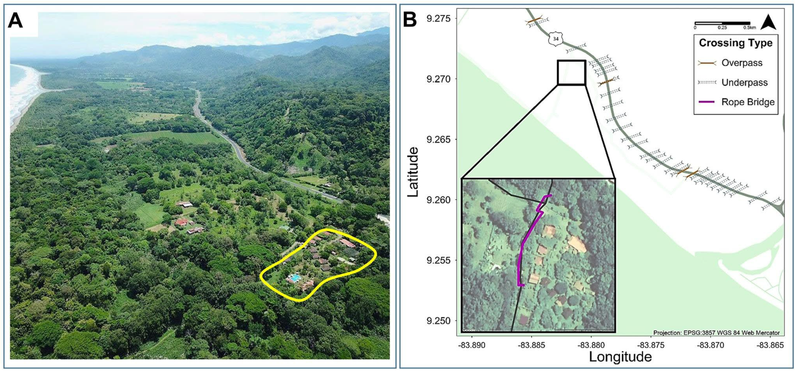
Costa Rica encompasses an area of 51,100 km2 and a population of almost 5.2 million inhabitants [18,19]. Geographically, Costa Rica is positioned on the isthmus that unites North and South America, acting as a land bridge in which continental species migrate, coexist, compete, and reproduce. Biologically, Costa Rica holds a special position, containing over 500,000 species that represent 6.5% of global biodiversity, and with 26% of the national territory under protected status [18]. Costa Rica’s growing economy requires an extensive road network to provide transportation, services, communication, and development to all regions. The rapid development of ecotourism in Costa Rica [20] has also contributed to an expanding road network with consequent increases in traffic around protected areas [21]. Despite its small territorial size, the Costa Rican road network is one of the densest in the world, with a total of 47,905 km of highways [18]. The vehicle fleet grew by 80% during 2007–2016, increasing from 797,000 to 1.43 million vehicles, including a cargo truck fleet that increased from 14,484 to 37,397 trucks over the 10-year period [22]. A recent analysis identified 600 km of national highways that represent a high risk for wildlife, half of which are in protected areas [23] (Figure 1A).
The geographical, biological, and economic factors driving road development has resulted in relentless roadkill mortality of wild mammals, putting at risk rare and endangered species (e.g., the bush dog Speothos venaticus [24], jaguar Panthera onca [14], and Baird’s tapir Tapirus bairdii [15]). In response, Costa Rica has begun to incorporate wildlife-crossing structures into its road expansion plans [25]. The first wildlife-crossing structures in Costa Rica were built at the Hacienda Baru National Wildlife Refuge (hereafter ”Hacienda Baru”) as part of the expansion of Route 34 from a secondary gravel road to a primary national highway in 2010 (Figure 1A,B). National Primary Route 34 (officially “Carretera Pacífica Fernández Oreamuno”, popularly the “Costanera Sur”) is one of the 19 main routes that make up the national primary road network and is situated along the Pacific coast [26]. Connecting popular tourism and commercial sites, thousands of vehicles travel this route every day, including trucks transporting cargo from the north to the central valley and south to the border with Panama. With support from Hacienda Baru staff, two research studies were conducted at Hacienda Baru after the installation of the crossing structures in 2010: the first was based on citizen science and involved community monitoring of roadkill mortality [27], and the second was a thesis project [4] examining the use of the crossing structures via camera traps. Following these studies, Hacienda Baru has continued to monitor wildlife use of the crossing structures with camera traps.
The purpose of this study is to contribute quantitative and qualitative data to assess the effectiveness of wildlife-crossing structures as a means to mitigate the negative impacts of highways in the tropics. We document the history, effectiveness, and lessons learned from the wildlife crossing structures at Hacienda Baru from 2010–2022. According to the guidelines for the development of wildlife-friendly roads, mitigation structures should be accompanied by a program to monitor the effectiveness of wildlife crossings by (a) documenting the extent to which wildlife species utilize the structures, and (b) comparing the frequency of roadkill mortality with and without the structures [25,28]. To assess the effectiveness of wildlife crossings, the “before-and-after impact” design compares roadkill mortality in the presence of the crossing structures with mortality at the same road location before the crossings were present, with the same site serving as its own control [29]. When it is not possible to study the impact of a site prior to the construction phase, the “control-impact” design provides the alternative with the best inferential strength [29]. In this design, roadkill mortality at the crossing structure vicinity is compared simultaneously with nearby control sites on the same road. Because Route 34 was enlarged at the same time as the crossings were built, it was not possible to create a true before-and-after study design (traffic before construction would have been much less than after the highway was enlarged), and we chose instead to employ the control-impact design, comparing wildlife mortality to control segments of the same highway using data obtained from [27]. Significantly, although many wildlife-crossing investigations have been conducted in Costa Rica since 1996, e.g., [8,30,31,32,33], none have assessed the use and effectiveness of mitigation measures utilizing a controlled study design such as the control-impact approach.
Because the wildlife crossings at Hacienda Baru were specifically designed to mitigate collisions with mammalian wildlife, and camera traps work best for documenting the passage of medium- to large-sized mammals, we limited the scope of our investigation to wild species of mammals and did not include other vertebrates or domestic animals. To provide additional information and context, we also offer a direct narration of author J.E.E. who has managed Hacienda Baru since 1972 [34,35], first proposed wildlife crossings, and continues to live on the site, along with co-author R.V.-H., who participated in the installation and monitoring of the crossings before and after their construction. This study represents the first documented observations in Costa Rica of the use and effectiveness of subterranean and aerial passageways by wildlife in which it is possible to compare roadkill mortality in the presence versus the absence of wildlife-crossing structures.

2. Materials and Methods

2.1. Study Site

The Path of the Tapir Biological Corridor (PTBC) is located on the Pacific slope of Costa Rica and connects the coastal ecosystems of the Osa Peninsula in the southeast, with the montane forests of the Talamanca mountain range to the north [36,37]. One of the main objectives of the PTBC is to facilitate the movement of fauna between the Osa Peninsula and the Talamanca mountains [36,37]. The corridor is named after the endangered Baird’s tapir, which lives in the Talamanca mountains and the Osa Peninsula, but was extirpated from the intervening area of the corridor in 1957 [35]—it is hoped that tapirs will soon inhabit the PTBC once again. A major threat to the biodiversity and functional integrity of PTBC’s connectivity routes are the highways that cross the corridor and result in frequent roadkill when animals attempt to cross them [37]. One of the greatest threats occurs where the PTBC intersects with National Route 34. Since its completion in 2010, Route 34 has been responsible for a large number of roadkill mortalities [27,37]. The Hacienda Barú National Wildlife Refuge is located in the critical section of connectivity where Route 34 bisects the reserve within the PTBC (Figure 1A,B).
Hacienda Barú is a private nature reserve located on the Pacific coast in southwestern Costa Rica near the town of Dominical (9°16′31.41″ N, 83°52′20.36″ W). Bounded by mature forest to the east, pasture and secondary forest to the north, the Pacific Ocean to the west, and the Baru River to the south, it is comprised of 330 hectares of primary, secondary, gallery, and swamp forests, mangrove wetlands, and beach front (Figure 2A). About half of the area is flat lowland and half is hilly, reaching a maximum altitude of 325 m. Hacienda Barú has been actively involved in the restoration and conservation of tropical nature and protection of wildlife since the mid-1970s when it was still a cattle ranch [34,35]. It was officially designated a national wildlife refuge in 1995. Located approximately in the middle of the 80 km long Path of the Tapir Biological Corridor, it is one of only three locations where the natural vegetation extends from the main body of the corridor in the highlands all the way to the beach. Hacienda Baru protects a high level of biodiversity and has identified 40 species of terrestrial mammals, many that appear on the IUCN Red List of threatened species [37].

2.2. History of the Wildlife-Crossing Structures

When a major enlargement of the road bisecting Hacienda Baru (hereafter Route 34) was in the advanced planning stage by MOPT (Ministry of Public Works and Transports), the staff of Hacienda Baru became concerned about the impact that the enlarged highway would have on wildlife. An unintended wildlife overpass had been erected many years earlier over what was then a 4 m wide gravel road. Plastic water pipes had been used for decades to bring water from a spring on the hillside on one side of the road to houses on the other side. For a number of years, the pipes had crossed under the road, but this created a problem every time heavy machinery damaged the pipe. After one such incident in 1989, a half-inch plastic hose was suspended above the road to avoid having to replace it every few years. From where the hose was attached to a tree on one side of the road to a tree on the other side was a distance of approximately ten meters. This was not intended to be an animal crossing, but over the next 20 years at least 5 arboreal species crossed the road on the hose: common opossum Didelphis marsupialis, northern tamandua Tamandua mexicana, white-faced capuchin monkey Cebus capucinus, kinkajou Potos flavus, and olingo Bassaricyon gabbii. It was thus known that wildlife would use an overpass structure to cross the road.
In the mid-2000s, Hacienda Baru staff expressed their concern to MOPT about the increase in roadkill that would occur with the advent of high-speed traffic. Subsequently, Hacienda Baru and the professionals elaborating the Environmental Impact Study (EIS) agreed to build a series of wildlife overpasses and underpasses to address the concerns. The locations for the structures were determined by first ascertaining where the animals were already accustomed to cross the narrow, gravel road. Many of these wildlife crossings were familiar to those who lived on Hacienda Barú and who had often observed animals crossing in certain places; other crossings could be inferred from game trails present on both sides of the road. There were 13 customary crossings, and the EIS specified 13 square or rectangular underpasses designed specifically for wildlife (Figure 3A,B). The smallest was 1.5 m square and the largest was 1.5 m wide by 2.5 m high because it was designed for the use of tourist groups. In addition to the 13 wildlife underpasses, the EIS specified 16 culverts designed for drainage, for a total of 29 tunnels. Nine of the drainage culverts were to be square or rectangular, and seven were to be round. It was unknown whether wildlife would use the culverts, but since water only flows through the culverts during heavy rains, most of the time they were available for wildlife.
Hacienda Baru proposed an overpass (bridge) design that was accepted by the EIS committee. The bridges were made of two 5/16 inch cables with space bars to hold them about 40 cm apart; the space between the two cables was to be covered with green shade cloth used to cover nursery plants, which is highly resistant to sunlight. Later, when construction was in progress in early 2010, a third cable was added; this cable was placed about 30 cm above the bridge so that the monkeys could grasp it with their tails (Figure 3C,D). There was one other difference from the original design. Rather than covering the bridges with the shade cloth, the bridges were covered with a plastic mesh similar to netting but not as flexible. After 7–8 years of exposure to sunlight, this material deteriorated considerably and currently pieces can be observed hanging from the cables, no longer providing a secure surface for animals to walk on. This has not diminished the use of the bridges as the animals tend to walk on the cables rather than the netting.
The locations for the overpasses were determined by (a) the availability of healthy trees strong enough to support the bridge, and were (b) located in places where there was a shorter distance between the forest canopies on the uphill and downhill sides of the highway. By chance, suitable trees were found in the only two areas that had been internal biological corridors used by wildlife since the mid-1980s when most of the rest of the land was still pasture (what was once pasture is currently all secondary forest). The two shortest bridges were placed on either side of the location where the water pipe once spanned the road. Bridge #1, the farthest south, measured 48 m from anchor tree to anchor tree, and bridge #2 measured 26 m from anchor tree to anchor tree (Figure 2B). Because the anchor trees on the uphill side are set back into the forest rather than being right at the edge, the part of the bridge that is suspended in open air above the highway is only about 13 m for each bridge. Animals have no other option but to stay on the bridge for the open-air segment, but may leave the bridge and move onto the branch of a tree once they have that option. About one kilometer north of bridges #1 and #2 are two longer bridges (#3 and #4), which are 73 and 43 m between anchor trees, respectively. They were located near a place where branches from trees on either side of the road had overlapped and formed a natural overpass for the wildlife. The open-air measurements of these bridges were 26 m and 36 m, respectively (Figure 2B). During the actual construction of the bridges, Hacienda Barú guides with experience in tree climbing helped with the attachment of the cables. To prevent them from falling in a windstorm, the anchor trees were themselves anchored using 3/8 inch cables tied to two large trees. To prevent the cables from cutting into the trees, the parts that made contact with the trunk were covered with plastic hose. All of the bridges were erected to the legal minimum of 5.5 m above the middle of the highway.

2.3. Literature Search

To provide context for road ecology research in Costa Rica, we searched for road ecology studies conducted in Costa Rica by searching in Google Scholar and Google search engines using a wide variety of search words, including “roadkills”, “road ecology”, and “wildlife crossings”, in both English and Spanish. We included journal articles, technical reports and theses (gray literature), conference presentations, and news articles. Some sources were provided by colleagues working in the Costa Rica conservation and road ecology community.

2.4. Quantitative Studies

We utilized two quantitative studies conducted at Hacienda Baru:

2.4.1. PRASCOSUR

PRASCOSUR is the acronym for “PRotejamos los Animales de la COstanera SUR” (We Protect the Animals of the Southern Coastal Highway), a citizen science organization that conducted a 1-year study to assess the impact of the highway along a 42 km segment of Route 34 from the northern limit of Hacienda Barú National Wildlife Refuge south to the boundary of the Térraba Sierpe National Wetlands [27]. With the help of local and international volunteers, PRASCOSUR conducted biweekly monitoring surveys between 6:00–9:00 AM on foot or by bicycle along 14 three-kilometer transects of Route 34 from 1 January to 31 December 2014. All roadkill was documented, located with GPS, and identified by taking photos before removing them from the highway (if dead) or taking them to a veterinarian (if injured). This study was never formally published, but was shared through several presentations, posters, and technical reports that were disseminated locally. The raw data from the study were shared with us by Susana Garcia-Blanco (personal communication), allowing us to conduct additional analysis and to prepare new graphs from the raw data.

2.4.2. Venegas Thesis

Marta Venegas conducted a study in 2015–2016 as her final report for the Bachelor of Science degree at the National University School of Biological Sciences (UNA), a common practice for undergraduate degree completion in Latin America [4]. The Spanish-language thesis was titled “Functionality of underground structures as passageways for wildlife in the Hacienda Barú National Wildlife Refuge, Puntarenas, Costa Rica” (English translation). Her thesis committee included Esther Pomareda, the lead author for the “Environmental Guide to Wildlife-friendly Roads” [25] and director of the Roads & Wildlife Commission that has taken the lead in promoting road ecology studies in Costa Rica. In her study, Venegas placed camera-trap cameras in 23 underpasses (both round culverts and rectangular underpasses) along the section of Route 34 that passes through Hacienda Baru National Wildlife Refuge for nine months, from September 2015 to July 2016. The analysis and results of the camera-trap study are contained in the thesis [4].

2.5. Narrative Case Study

In addition to the quantitative studies of roadkill and wildlife use of crossing structures at Hacienda Baru by [4,27], we prepared a narrative case study that integrated the lifetime knowledge and insights gained by author J.E.E. based on living at Hacienda Baru from the 1970s, when it was managed as a cattle ranch, through the process of ecological restoration, ecotourism development, and scientific research that continues to this day [34,35], and supplemented by the recollections of coauthor R.V.-H., former coordinator of the Hacienda Barú Biological Research Center. The intent of the narrative account was to provide a historical context and fill in the gaps not covered by the PRASCOSUR and Venegas studies [4,27].

3. Results

3.1. Literature Review: Research and Promotion of Road Ecology in Costa Rica

Our literature review indicated a broad interest in studying and promoting road ecology in Costa Rica. We located a total of 50 references on road ecology topics (mortality risk, mitigation) from Costa Rica over the past 25 years. All but one of the references were communicated in Spanish. We located 11 journal articles, all but one published in local Spanish language journals, as well as 16 research reports disseminated in the “gray literature” as thesis papers for Bachelor’s or Master’s degrees and technical reports (Supplementary File S1). An additional 23 conference presentations (posters or video presentations) were also located online. Aside from research reports, news articles and other media reports often presented valuable information on road ecology topics not otherwise documented in the formal literature. Some references that were cited in articles or reports could not be located; thus, our review is doubtless an underestimate. Of the 26 references listed in Supplementary File S1 as journal articles, theses, or technical reports, half examined roadkill mortality (n = 13) and the rest reported on wildlife crossings and other mitigation efforts (n = 13). Although these resources produced a diversity of results, the general conclusion was that (a) highway traffic is responsible for a significant mortality of wild species, and (b) wildlife species use crossing structures when they are available, although the time delay before they are utilized depends on the species and the physical context of the crossing structure.
The “Roads & Wildlife Commission” (Comisión de Vías y Vida Silvestre, hereafter the “Commission”) is an interdisciplinary group formed in 2012 and made up scientists, academics, and representatives of non-profit organizations; universities; wildlife management; and other governmental entities, all with a common interest in transforming the Costa Rican road system into “vias amigables”, roads that are friendly to wildlife. In November 2013, the Commission sponsored a symposium at the National Distance University (UNED) to promote road ecology research that attracted 167 participants and 27 oral presentations plus poster presentations, the majority being research investigations conducted in Costa Rica [38] (oral presentations on YouTube at https://youtu.be/0t72UgtRK1A; accessed on 10 August 2022). In 2014, the Scientific Committee of the Commission produced a 75-page “Environmental Guide to Wildlife-friendly Roads” [25] designed to provide decision makers and activists with the foundational information needed to engage in road ecology research and to promote mitigation measures in the face of an ever-expanding transportation infrastructure. The Commission has also been active in promoting road ecology and maintains a Facebook group with over 2740 members [39]. In 2018, the Commission released nine short television spots for the “Campaign against wildlife roadkills in Costa Rica” [40], and in 2019 it sponsored four public service spots and two micro-podcasts for dissemination on by radio stations [41].
Nine of the roadkill mortality studies located in the literature (not including the PRASCOSUR study) had a large enough listing of mammalian species to enable a comparative analysis [21,23,30,33,42,43,44,45,46]. The most frequent medium-to-large non-volant mammal species recorded as roadkill were common opossum, northern tamandua, northern raccoon Procyon lotor or crab-eating raccoon P. cancrivorus, and nine-banded armadillo Dasypus novemcinctus (see Table 1). The percentage of total mammalian mortalities for all these species combined ranged from 30% to 79% ([21]: 30%; [30]: 39%; [33]: 47%; [23]: 48%; [43]: 57%; [44]: 63%; [45]: 63%; [46]: 69%; [42]: 79%). In eight of these studies (89%), common opossum was the most frequent roadkill species, with the percentage of the total ranging from 21% to 50% [23,30,33,42,43,44,45,46]. Tamandua was the most frequent roadkill in the ninth study [21] (18.2%), as it was the PRASCOSUR study (18.3%) [27]. Arboreal species included primates, sloths, and squirrels. Three of the studies recorded significant numbers of bat mortalities (8–24% of the total: [21,23,33], compared with 16% of all mortalities for the PRASCOSUR study). Finally, two of the studies and the PRASCOSUR survey recorded felids in their roadkill mortality ranging from 1–24% ([21]: 3%; [23]: 24%; PRASCOSUR [27]: 1%).

3.2. Quantitative Data Obtained from Hacienda Baru

3.2.1. PRASCOSUR Study: Roadkill Mortalities

A total of 291 animals were found dead on the road during 142 monitoring surveys, with an average of 2 roadkills for each 3 km survey transect. Of the road killed animals, 24% were mammals, 13% were birds, 30% were reptiles, and 33% were amphibians [27]. A total of 87 mammal roadkills were recorded (Figure 4). Fourteen species of medium-to-large terrestrial mammals (mice not included) were identified: striped hog-nosed skunk Conepatus semistriatus, white-nosed coati Nasua narica, northern tamandua, common opossum, raccoon, Mexican hairy porcupine Coendou mexicanus, kinkajou, howler monkey Alouatta palliata, gray four-eyed opossum Philander opossum, nine-banded armadillo, white-faced capuchin monkey, brown-throated three-toed sloth Bradypus variegatus, collared peccary, and tayra Eira barbara (Table 1). The most frequently road-killed nonvolant mammals recorded, making up 47% of mortalities, were northern tamandua (16.7%), striped hog-nosed skunk (12.7%), common opossum (9.5%), and white-nosed coati (7.9%). Unidentified microchiropteran bats made up the second-highest mortality group (18%). The lowest roadkill frequency of terrestrial mammals was observed for coyote Canis latrans, variegated squirrel Sciurus variegatoides, nine-banded armadillo, ocelot Leopardus pardalis, collared peccary Pecari tajacu, and southern spotted skunk Spilogale angustifrons (0.8% for each), which totaled 5% of all mortalities (Figure 4).
In the 3 km transect fronting Hacienda Baru (transect T14), 0.25 vertebrate mortalities were recorded per monitoring survey (Figure 5A); this was the lowest mortality rate observed for all the survey sections except T6 and compares with a roadkill rate of 4.0 road-killed vertebrates per survey at Térraba Sierpe and the overall average of 2.0 road-killed vertebrates per survey transect for the entire 42 km length of monitored highway [27]. For mammalian roadkill, the T14 transect at Hacienda Baru recorded 0.19 mammal roadkills per survey (or 5.3 surveys per roadkill mammal) compared with the average of 0.75 mammal roadkills per survey for the other sections (1.3 surveys per roadkill mammal; Figure 5B). Although transect T6 also had a low frequency of 0.15 mammal roadkill per survey (Figure 5B), this was probably because T6 is located in the city of Uvita, where businesses and other human structures dominate the highway rather than forest or other natural habitats. The low rate of roadkill recorded at Hacienda Baru was attributed to the profusion of mitigation structures crossing both under and over the road in that segment of highway. PRASCOSUR concluded their report with the recommendation that similar mitigation measures be implemented along other sections of Route 34 [27].

3.2.2. Venegas Study: Use of Crossing Structures at Hacienda Baru

Based on 1279 independent photo records, Venegas [4] observed 21 species of terrestrial vertebrates using the underpasses, including 14 species of mammals (8 species listed as vulnerable): common opossum, gray four-eyed opossum, northern tamandua, nine-banded armadillo, spiny rats Proechimys spp., Central American agouti Dasyprocta punctata, paca Cuniculus paca, raccoons, white-nosed coati, greater grison Galictis vittate, tayra, striped hog-nosed skunk, ocelot, and collared peccary (Table 1). The most frequently recorded species of medium-to-large terrestrial mammals using the underpasses (85% of records) were paca (37%), collared peccary (29%), and agouti (19%); the lowest use of the underpasses was recorded for striped hog-nosed skunk, gray four-eyed opossum, northern tamandua, and common opossum (5% total). Bats were not observed using the underpasses to travel, only to roost. Of the 14 mammalian species recorded by Venegas [4] as using the wildlife crossings, 9 species were recorded as roadkill by PRASCOSUR [27]: striped hog-nosed skunk, white-nosed coati, northern tamandua, common opossum, gray four-eyed opossum, raccoon, nine-banded armadillo, paca, and tayra (Table 1; Figure 5).

3.3. Narrative Case Study

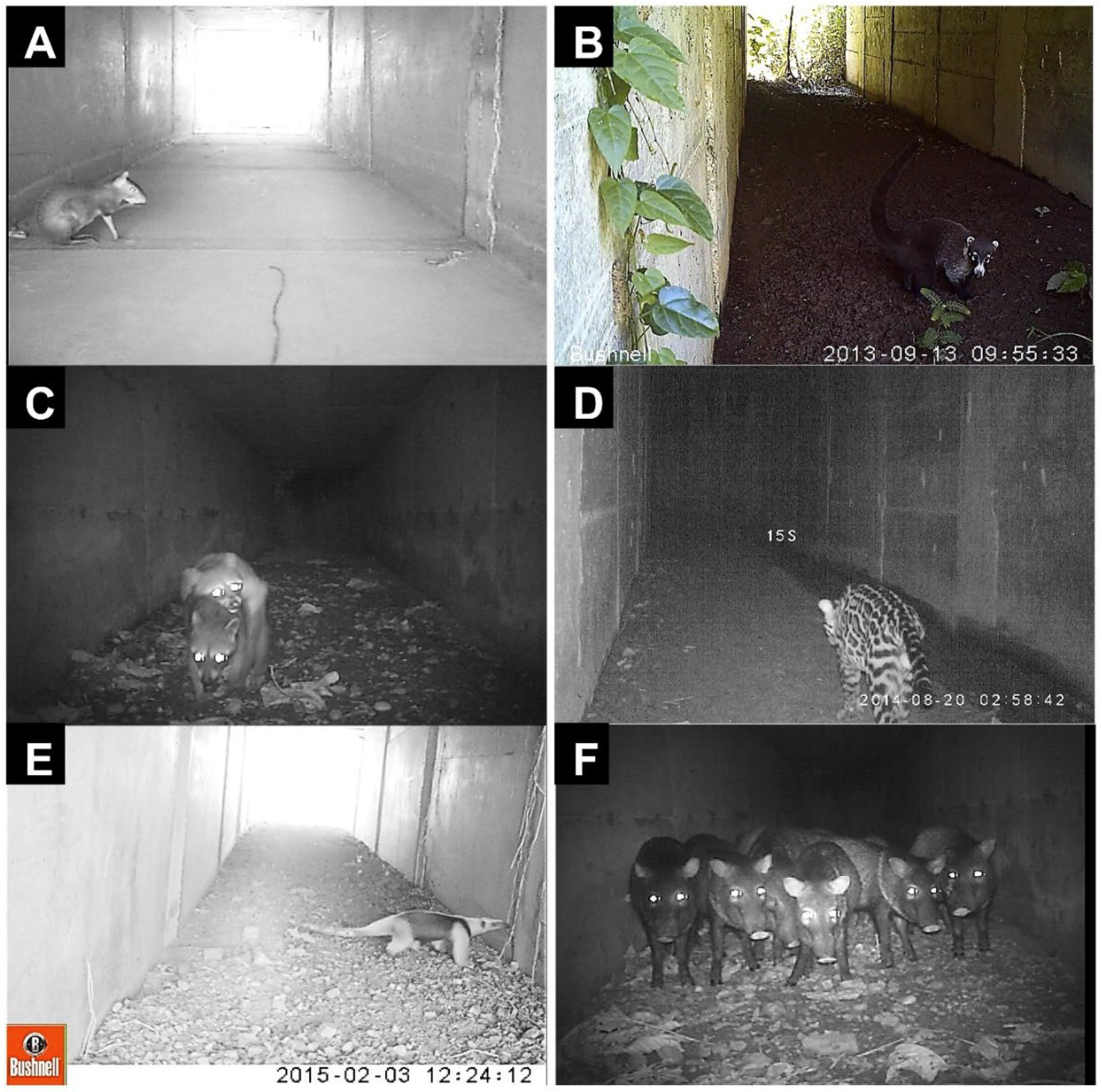
On 29 April 2010, Costa Rican President Oscar Arias inaugurated National Route 34, the Pacífica Fernandez highway (“Costanera Sur”). The highway included the first underpass wildlife crossings of this type built in Costa Rica. During the first years of the operation of the wildlife crossings, the staff of Hacienda Baru conducted a regular survey of the 3 km stretch of highway that passes through the refuge. In the second year, track stations were established on both sides of the underpasses from August to March 2011. The 50 cm × 50 cm track plots were monitored regularly by counting the footprints and afterwards cleaning the plot. In June of 2013, Hacienda Baru placed their first camera trap in the 1.5 m × 2.5 m tunnel. Over 5 days, the camera recorded 33 videos of animals, most of them collared peccary, but there were several videos of pacas and solitary male white-nosed coatis (Figure 6A–F). Over the next few years, thousands of animals were recorded on camera traps crossing under the highway (Table 1). Altogether, 17 different species were photographed, but green iguanas Iguana iguana and the unidentified species of bats did not use the tunnels to cross the highway. The iguanas were only observed sunning themselves in the openings, and the bats roosted in the tunnels. Fifteen mammal species were photographed crossing the highway by way of the underpasses (Figure 7A–F): common opossum, gray four-eyed opossum, northern tamandua, nine-banded armadillo, white-nosed coati, white-faced capuchin, paca, collared peccary, Central American agouti, northern raccoon and/or crab-eating raccoon (they could not be distinguished from the photos), striped hog-nosed skunk, and three carnivores—ocelot, jaguarundi Herpailurus yagouaroundi, and tayra (Table 1). Those records of animals using the underpasses were later confirmed by Venegas [4].
Although certain species, such as collared peccary, used the underpasses right away (even before construction was complete), it took longer before other animals used the overpass bridges. Due to the past experience with the waterpipe, it was believed that at least monkeys would use the overpasses. However, no animal sightings were reported on the bridges for a year and a half after the completion of the overpasses. Finally, at 1 year and 7 months, a group of white-faced capuchin monkeys was sighted and photographed on bridge #2. A few weeks later, a different troop of capuchins was sighted on bridge #1. Soon, it was common to observe troops of 10 to 15 capuchins with their young on overpasses #1 and #2 in the morning and afternoon—traffic and tourists stopped to observe them and take pictures. The monkeys used the green mesh to play on, rest, or watch the cars, and almost all of them used the free cable to hold on by the tail when they crossed. Another three years passed before another troop of capuchin monkeys were observed on the longer bridges, #3 and #4 (Figure 7A).
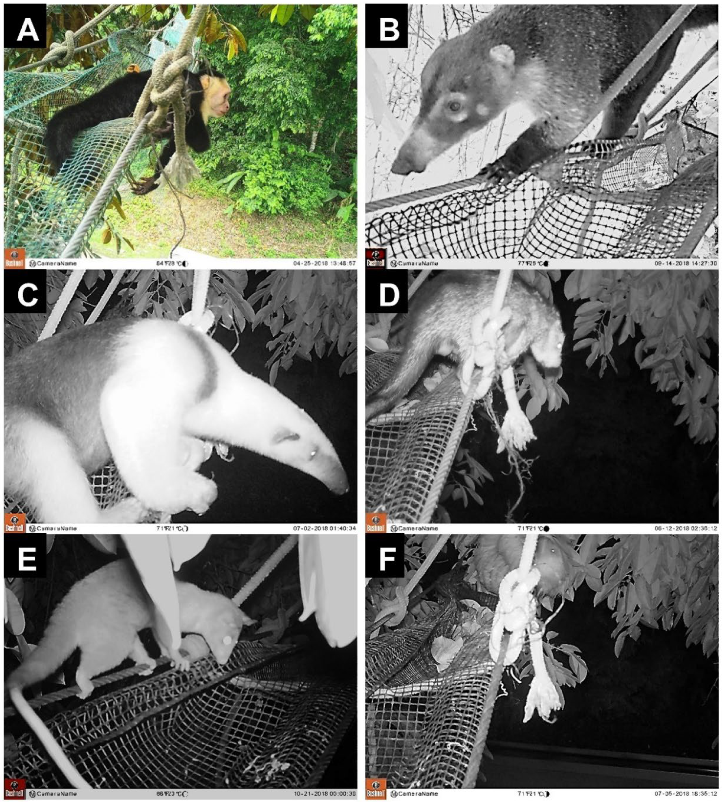
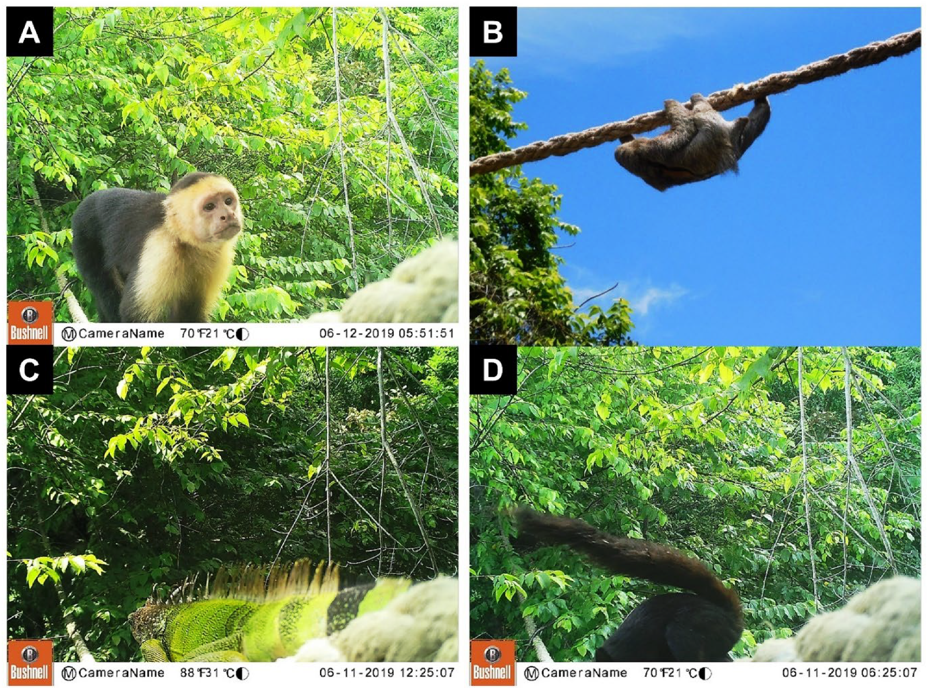
In 2017, Hacienda Baru placed some cameras at each end of the two shorter bridges (#1 and #2). Over the next year, nine species were recorded using the bridges to cross the highway (Figure 7A–F): common opossum, northern tamandua, white-faced capuchin, white-nosed coati, kinkajou, Central American woolly opossum Caluromys derbianus, brown-throated three-toed sloth, Hoffman’s two-toed sloth Choloepus hoffmanni, and Mexican hairy porcupine (Table 1). In mid-2018, Hacienda Baru purchased 200 m of second-hand, two-and-a-half-inch thick mooring rope that had been used for tying ships to the dock. The rope was extended across and along the service road that goes from Route 34, past Hacienda Barú Lodge, and all the way to the beach (Figure 2B). The road is single-lane dirt and only seven meters wide, so the crossings are short compared to the highway bridges, with open space crossings from 5 to 19 m. Within a few weeks, monkeys, sloths, squirrels, and iguanas were observed traversing the ropes (Figure 8A–D). The monkeys sometimes ran on them as if they were a race track. About a year after establishing the rope bridges, cameras were placed at the end of bridge #5 and the beginning of bridge #6. Nine species were recorded at both rope bridge locations: common opossum, northern tamandua, brown-throated three-toed sloth, Hoffman’s two-toed sloth, white-faced capuchin, Mexican hairy porcupine, green iguana, and variegated squirrel (Table 1), as well as the common spiny-tailed iguana Ctenosaura similis. Although white-faced capuchin monkeys are assumed to be diurnal, on three occasions photographs were taken of individual capuchins that walked across rope bridge #5 between 21:33 and 03:20 h, indicating some activity at night.
Groups of female white-nosed coatis with young have stopped moving back and forth between the highlands and lowlands. It is well known that coati males (“coatimundis”) are almost always solitary, whereas the females travel in groups of 10–20 with their young. Males have been sighted crossing on both the highway bridges and through the tunnels, but a group of females has never been observed using either, and no coatis have been killed on the highway. Prior to the construction of the new highway, groups of coatis were often seen crossing the narrow gravel road.
Although sightings of Mexican hairy porcupines have always been rare on Hacienda Barú, they are now using both the overpasses and the rope bridges. Previously, porcupines were known to be present, but it was always assumed that there were very few of them. Since the construction of the crossings, porcupines have been photographed on three of the highway bridges (#1, #2, and #3), and on both the long and short spans of mooring rope (#5 and #6). Because bridges #1 and #2 are separated from #3 and #4 by around one kilometer, and another kilometer separates those from the mooring rope bridges, the porcupines at the different locations are almost certainly different individuals. This may mean that there are many more porcupines at Hacienda Barú than previously imagined.

4. Discussion

This is the first road ecology study in Costa Rica to compare the effect of wildlife crossings using a control-impact design [29], in which the roadkill mortality of wildlife inhabiting the vicinity of the crossing structures was compared to control sites on the same highway lacking crossing structures. The quantitative studies supplemented by the narrative account provide strong evidence that the underpasses and overpasses at Hacienda Baru have been well-used by wildlife over the 12 years since they were constructed, and that their presence has reduced the number of roadkill mortalities that would otherwise have occurred without the crossings. Specifically, 18 species of medium-to-large mammals were documented as roadkill mortalities along the 42 km stretch of Route 34 surveyed by PRASCOSUR [27], while 13 medium-to-large mammal species (spiny rats omitted) were documented using the wildlife crossings by Venegas [4], including 78% of the species documented as roadkill, plus another 4 species. Based on camera-trap records by Hacienda Baru and previous studies [4,27], a total of 21 medium-to-large mammals (Table 1) are using the underpasses and overpasses, including all the road-killed species documented by PRASCOSUR [27], except howler monkey, coyote, and southern spotted skunk, plus seven new species: Central American agouti; paca; Central American wooly opossum; greater grison; Hoffmann’s two-toed sloth; and two felids, jaguarundi and ocelot.
The 3 km section of Route 34 passing through Hacienda Baru recorded only 26% of the mean mammal roadkill per monitoring survey for all transects along the 42 km segment (0.1875 vs. 0.7129 roadkills per transect per monitoring survey [4]). Based on the comparison with other segments of the highway [27] and the higher mortality rate from incidental observations at Hacienda Baru in 2010 when animals were still learning to use the wildlife crossings, it is reasonable to postulate that the lower rate of collision mortality on the 3 km Hacienda Baru stretch of Route 34 recorded by the PRASCOSUR survey [27] is attributable to the presence of the 33 wildlife-crossing structures (29 underpasses and 4 overpasses) that enable wildlife to travel safely from one side of the highway to the other. Although the two quantitative studies were not conducted simultaneously, it is interesting to note that the two species with the highest roadkill mortality according to PRASCOSUR [27], northern tamandua and striped hog-nosed skunk, also had the lowest use of the underpasses according to Venegas [4] (combined 30% of mortalities versus 1.5% of underpass use). Similarly, paca and collared peccary, species with very low roadkill mortality (combined 2.3%), were responsible for the majority of underpass use based on relative abundance of camera-trap photos (66%) from the same studies. This suggests that, for some species, the use (or lack of use) of the wildlife crossings is inversely correlated with roadkill mortality, which is another indication of the success of the mitigation crossing structures.
Ascensão et al. [29] argued that a lack of roadkill mortality may mask either local mass extinction (not relevant to a national wildlife refuge) or a “barrier effect” in which individuals are unable or reluctant to cross the road. A barrier effect is not supported in this study because our data indicate that low roadkill mortality was associated with the use of the wildlife passages as an alternative to crossing the road surface. Furthermore, those species with low roadkill mortality did experience some mortality, even though the majority of individuals chose to use the crossings. Venegas [4] observed a greater abundance of wildlife using the rectangular underpasses designed for wildlife compared with the round culverts designed primarily for drainage. However, some animals did use the culverts. Because there was no one structural design that was ideal for all species, Venegas [4] recommended that a good strategy would be to provide a variety of crossing structures to meet different species needs. In agreement with the observations at Hacienda Baru, a comprehensive review and meta-analysis of 270 studies [47] concluded that crossing structures built specifically for wildlife were used significantly more than those built for dual use by humans and wildlife, and that wildlife preferred a passageway that most closely resembled their natural habitat.
Carara National Park (PNC) can serve as another control site to Hacienda Baru in addition to the 42 km segment of Route 34 surveyed by PRASCOSUR [27]. Located 126 km north of Hacienda Baru along National Route 34, PNC has no wildlife-crossing structures along the 4 km stretch of Route 34 adjacent to the park. A study conducted by Arevalo et al. [21] revealed a high volume of traffic that was strongly related to tourism, with a mean of 418 vehicles per hour on weekdays, 777 vehicles per hour on weekends, and a peak of 1200 vehicles per hour during the high season in January. The study found that higher volumes of traffic resulted in more roadkill. The relative mortality of mammals was 2.7 mammals per day along the 4 km segment adjacent to the park, with 11 species of large mammals killed, including northern tamandua, white-nosed coati, common opossum, raccoon, ocelot, and kinkajou. Interestingly, northern tamandua roadkill represented 18% of the total for the Carara [21] and PRASCOSUR [27] studies, although tamandua was the most frequently killed species in the PRASCOSUR study versus the third most common mortality in the Carara study (where mice and rats were the most frequent roadkill groups at 27%: [21]). The authors of the Carara study [21] recommended the construction of underpasses and aerial bridges at PNC.
Our literature review discovered 50 road ecology references from Cosa Rica over the past 25 years, a high number for a small country with no public funding for such research [48]. Some of these studies documented roadkill along other busy Costa Rican highways lacking in mitigation structures. As an example, a study of busy Route 32 in Limón province [33] recorded 24% of the wild mammal species in the country, but only five species made up 88% of roadkill. Similar to other studies in Costa Rica, the large terrestrial mammals most impacted by roadkill were the common opossum, nine-banded armadillo, and gray four-eyed opossum, while the most affected arboreal mammals were the Central American woolly opossum and Hoffmann’s two-toed sloth [33]. Other road ecology studies in Costa Rica [25] identified additional, large mammals vulnerable to road-related mortality, including the northern tamandua, raccoon, and white-faced coati; the arboreal mammals most likely to use crossing structures included procyonids (raccoon, coati), opossums, and primates [49]. Interestingly, all these species have been observed using the crossing structures at Hacienda Baru.
Unidentified species of Microchiroptera bats were the second-most-frequent group of roadkill mortalities for both the PRACOSUR study (15.6% of all mammals: [27]) and the study at Carara National Park (22.7%: [21]). Although bats were observed roosting in some of the underpasses at Hacienda Baru, they did not use them to cross the road. Rather, the bats would fly across the road where they were often hit by fast-moving vehicles. The inertia of the blow typically threw the bats towards the verge of the road or into the vegetation, where they were quickly devoured by ants and other decomposers. Sometimes the bats did not die instantly; in this case, the shocked or injured bats would wander until they died on the verge or in the vegetation. This is probably why bats are not always recorded in roadkill studies insofar as they do not generally fall on the roadway itself. As with birds, the smaller the animal, the greater the displacement from the roadway from the collision in full flight. For this reason, surveys conducted from a vehicle can easily miss dead bats and birds in the verge vegetation, while surveys conducted on foot or from a bicycle moving along the verge (such as in the PRASCOSUR survey) would be much more likely to record bat and bird mortalities.
There is a widespread concern that predators will learn that animal prey use the underpasses and then alter their behavior to exploit the crossing structures as a means to detect and capture prey (“predation-trap hypothesis” [50]). At Hacienda Baru, predators, such as ocelots, jaguarundis, and tayras, have been observed passing through the tunnels (Table 1), but there has never been any indication that they wait at the tunnel entrances for prey. Although this pattern should be verified by further studies, the literature records few reports of predation by wild predators near crossing structures. The majority of studies conclude that the empirical evidence for the prey-trap hypothesis is scant, largely anecdotal, and indicates infrequent opportunistic behavior rather than regular patterns of predation [46]. Most passage studies [50,51,52,53,54] record no evidence of predation in or around passages, and conclude that the use of crossing structures is determined by other factors. An exception is Mata et al. [55]; although they did not observe any predation events, their study suggested that some predators may attend wildlife crossings in search of prey, while some prey species may avoid using the crossings in the presence of predators.

4.1. Conclusions

The purpose of this study was to provide some of the first documented observations on the use and effectiveness of wildlife-crossing structures by wildlife in Costa Rica in which a highway with wildlife crossings was compared with a highway without such crossings. Best practices demand that mitigation strategies be accompanied by a program to monitor the effectiveness of underpasses and overpasses by documenting the extent to which wildlife species utilize the structures, and by directly comparing the frequency of roadkill in the presence of structures versus a control without structures [25,28]. Because the crossing structures were introduced at the same time that Route 34 was improved and enlarged, a before-and-after study would not have been possible because the “before” roadkills were undoubtedly less than they became after the road improvements enabled a greater volume of traffic and higher speed of vehicles. Although a quantitative study was not conducted immediately before and after the crossing structures were completed, observations by professional wildlife guides plus systematic studies conducted a few years after the wildlife crossings were constructed indicate that these structures have been successful in mitigating roadkill. A comparison of the very low rate of roadkill mortality at Hacienda Baru (with crossings) versus the higher rate of roadkill on Route 34 nearby and at Carara National Park (without crossings) provides relevant evidence in support of the contention that the crossing structures have successfully accomplished their purpose in protecting wildlife from road-related mortality. The success of the Hacienda Baru wildlife crossings was further supported by a global meta-analysis that examined the effectiveness of road mitigation measures aimed to reduce wildlife mortality on roads [56]. Based on 50 studies, they found that mitigation measures reduced roadkill by 40% compared to the controls [56].
An advantage of the narrative case study approach we employed was the ability to present both quantitative and qualitative data analyses, exploring the real-life dynamics and complexities involved in the history of planning, constructing, and monitoring the wildlife crossings [57]. For example, the 12-year perspective of this study enabled us to observe the long-term patterns of passage use indicative of a learning process. The underpasses were utilized very quickly by terrestrial mammals, with species such as collared peccary using them even while they were still under construction, while other species took longer to make use of them. It took over a year for arboreal species to start using the aerial overpasses, with the white-faced capuchin monkeys being the first species to venture out on the bridges. However, once accustomed to crossing the bridges, it appeared that many species were able to quickly generalize their learned behavior to incorporate the use of new structures such as the mooring ropes. The placement of tunnels and bridges at known crossing points along the highway no doubt accelerated the learning and habitation process. This points to the critical importance of road design engineers and ecologists collaborating with local people—landowners and tour guides, for example—to ensure that the crossing structures are strategically placed at customary wildlife-crossing points. It is interesting that the groups of female and young coatis apparently never learned to use the tunnels, while the male coatimundis did, perhaps reflecting the greater boldness and range of males as they search for females. In general, we expect that mammals will learn to use the subterranean underpasses early on, but aerial overpasses will require more time and patience.
The crossing structures, in combination with camera-trap surveillance, have had the unintended benefit of providing the refuge with new information about the behavior of elusive species. Mexican hairy porcupines were rarely observed during the daytime, but were abundant in the crossing structures at night, while white-faced capuchin monkeys did not appear to be strictly diurnal. Based on camera-trap records and field observations, it does not appear that predator species used the crossing structures for hunting prey. Perhaps, in time, an individual predator might learn to use the tunnels or bridges as an ambush site, but the fact that this has not happened over the past 12 years is encouraging. Additionally, although illegal hunters have occasionally used the tunnel entrances as ambush points, this has not been a regular occurrence, perhaps because it requires waiting a long time. However, illegal hunters did become a nuisance by stealing or vandalizing the cameras in an attempt to destroy evidence of their presence. This points to the importance of including environmental education at the community level alongside the placement of crossing structures.

4.2. Implications for Conservation

The case of Hacienda Baru indicates that, when properly designed, placed, and monitored, wildlife crossings can be effective in mitigating roadkill mortality in the developing nations of Central America and elsewhere. The placement of crossings at the location of habitual wildlife-crossing sites was made possible by years of observation and familiarity with the wildlife by the staff of Hacienda Baru, ensuring that the planning and location of mitigation structures were based on habitat functional connectivity [29]. According to Foster et al. [58], underpasses should be located where wildlife naturally cross roads. Thus, underpass placement based on the knowledge of actual travel routes may be more important in determining underpass use than other factors, such as structural dimensions. The success of these mitigation structures in Costa Rica is likely enhanced by a high level of public support for wildlife conservation combined with widespread Internet access and a high level of education [48]. The widespread public awareness campaign on social media, radio, and TV about making roads friendly for wildlife (“caminos amigables”) indicate a high level of public awareness and engagement in mitigating the negative effects of roads on wildlife in Costa Rica. Overall, the Hacienda Baru case provides strong evidence that conservationists, engineers, and government officials in a developing world context can work together to successfully mitigate the threat of roadkill mortality in the face of an expanding transportation network. The proven designs for wildlife crossings at Hacienda Barú can be replicated on other highways in the developing tropics to save thousands of animals from being killed by vehicle collisions and maintain connectivity and genetic exchange between populations.

Supplementary Materials

The following supporting information can be downloaded at: https://www.mdpi.com/article/10.3390/d14080665/s1, Supplementary File S1. Costa Rica Road Ecology Research References. Journals [8,21,30,33,43,44,45,46,59,60,61]; Theses [4,15,23,31,32,62,63,64,65]; Technical Reports [25,42,66,67,68,69]; Conference Presentations [27,38]; News and Media [39,40,41,70,71,72,73,74,75,76,77,78,79,80,81,82,83,84,85,86,87,88,89].

Author Contributions

Conceptualization, R.V.-H., J.E.E. and M.S.M.; methodology, R.V.-H., J.E.E. and M.S.M.; data curation, M.S.M.; writing—original draft preparation, J.E.E. and M.S.M.; writing—review and editing, R.V.-H., J.E.E. and M.S.M.; visualization, M.S.M. All authors have read and agreed to the published version of the manuscript.

Funding

This research received no external funding.

Institutional Review Board Statement

Not applicable.

Data Availability Statement

The data included in this paper are potentially available upon request from the authors.

Acknowledgments

We thank Susana Blanco for sharing the data from the PRASCOSUR survey, and Marta Venegas, Esmeralda Arévalo, and Adolfo Artavia for their valuable contributions to and comments on this article. We also acknowledge the guides of Hacienda Baru National Wildlife Refuge for their observations of wildlife on the crossings and highway over the years. We are also very grateful to Amy Eppert, Lily Bright, and Emily Bohnet for constructing g Figure 2B, Figure 4 and Figure 5, respectively.

Conflicts of Interest

The authors declare that there are no conflict of interest.

References

  1. Alamgir, M.; Campbell, M.J.; Sloan, S.; Goosem, M.; Clements, G.R.; Mahmoud, M.I.; Laurance, W.F. Economic, socio-political and environmental risks of road development in the tropics. Curr. Biol. 2017, 27, R1130–R1140. [Google Scholar] [CrossRef] [PubMed]
  2. Laurance, W.F.; Campbell, M.J.; Alamgir, M.; Mahmoud, M.I. Road expansion and the fate of Africa’s tropical forests. Front. Ecol. Evol. 2017, 5, 75. [Google Scholar] [CrossRef]
  3. Caro, T. Roads through national parks: A successful case study. Tropical Conserv. Sci. 2015, 8, 1009–1016. [Google Scholar] [CrossRef]
  4. Venegas, M. Funcionalidad de Estructuras Subterráneas Como Pasos de Fauna Silvestre en el Refugio Nacional de Vida Silvestre Hacienda Barú, Puntarenas, Costa Rica [Functionality of Underground Structures as Wildlife Passages in the Hacienda Barú National Wildlife Refuge, Puntarenas, Costa Rica]; B.Sc. Project Final Report; Universidad Nacional: Heredia, Costa Rica, 2018; 51p. [Google Scholar]
  5. Silva, I.; Crane, M.; Savini, T. The road less traveled: Addressing reproducibility and conservation priorities of wildlife-vehicle collision studies in tropical and subtropical regions. Glob. Ecol. Conserv. 2021, 27, e01584. [Google Scholar] [CrossRef]
  6. Hill, J.E.; DeVault, T.L.; Belanta, J.L. A 50-year increase in vehicle mortality of North American mammals. Landsc. Urban Plan. 2020, 197, 103746. [Google Scholar] [CrossRef]
  7. Barbosa, P.; Schumaker, N.H.; Brandon, K.R.; Bagera, A.; Grilo, C. Simulating the consequences of roads for wildlife population dynamics. Landsc. Urban Plan. 2020, 193, 103672. [Google Scholar] [CrossRef] [PubMed]
  8. Rojas-Chacón, E. Atropello de vertebrados en una carretera secundaria en Costa Rica [Roadkills of vertebrates on a secondary road in Costa Rica]. Res. J. Costa Rica Distance Educ. Univ. 2011, 3, 81–84. [Google Scholar]
  9. Pinto, F.A.S.; Clevenger, A.P.; Griloa, C. Effects of roads on terrestrial vertebrate species in Latin America. Environ. Impact Assess. Rev. 2020, 81, 106337. [Google Scholar] [CrossRef]
  10. Monge-Nájera, J. Road kills in tropical ecosystems: A review with recommendations for mitigation and for new research. Rev. Biol. Trop. 2018, 66, 722–738. [Google Scholar] [CrossRef]
  11. Kroll, G. An environmental history of roadkill: Road ecology and the making of the permeable highway. Environ. Hist. 2015, 20, 4–28. [Google Scholar] [CrossRef]
  12. Payan, E.; Soto, C.; Díaz-Pulido, A.; Benítez, A.; Hernández, A. Wildlife road crossing and mortality: Lessons for wildlife friendly road design in Colombia. In Proceedings of the 2013 International Conference on Ecology and Transportation (ICOET 2013), Scottsdale, AZ, USA, 23–27 June 2013; Volume 209D, pp. 1–8. [Google Scholar]
  13. Huijser, M.P.; Abra, F.D.; Duffield, J.W. Mammal road mortality and cost-benefit analyses of mitigation measures aimed at reducing collisions with capybara (Hydrochoerus hydrochaeris) in Sao Paulo State, Brazil. Oecol. Aust. 2013, 17, 129–146. [Google Scholar] [CrossRef]
  14. González-Gallina, A.; Hidalgo-Mihart, M.G.; Castelazo-Calva, V. Conservation implications for jaguars and other neotropical mammals using highway underpasses. PLoS ONE 2018, 13, e0206614. [Google Scholar] [CrossRef] [PubMed]
  15. Brenes-Mora, E. Patrones de Actividad, Selección de Hábitat y Atropellos de Danta (Tapirus bairdii) en Bosque Atravesado Por Una Carretera en la Cordillera de Talamanca, Costa Rica [Activity Patterns, Habitat Selection, and Roadkills of Tapir (Tapirus bairdii) in a Forest Crossed by a Road in the Cordillera de Talamanca, Costa Rica]. Master’s Thesis, Universidad Nacional, Heredia, Costa Rica, 2018; 95p. [Google Scholar]
  16. Poot, C.; Clevenger, A.P. Reducing vehicle collisions with the Central American tapir in Central Belize District, Belize. Trop. Conserv. Sci. 2018, 11, 1–7. [Google Scholar] [CrossRef]
  17. Birot, H.; Campera, M.; Imron, M.; Nekaris, K. Artificial canopy bridges improve connectivity in fragmented landscapes: The case of Javan slow lorises in an agroforest environment. Am. J. Primatol. 2020, 82, e23076. [Google Scholar] [CrossRef] [PubMed]
  18. MINAE-SINAC-CONAGEBIO-FONAFIFO. Resumen del Sexto Informe Nacional de Cosa Rica Ante el Convenio de Diversidad Biológica. Programa de Naciones Unidas Para el Desarrollo-Apoyo Técnico Para Que Las Partes Elegibles Desarrollen el Sexto Informe Nacional Para el CDB (GNR_LAC) Costa Rica [Summary of the Sixth National Report of Cosa Rica before the Convention on Biological Diversity. United Nations Development Program-Technical Support for Eligible Parties to Develop the Sixth National Report for the CBD (GNR_LAC) Costa Rica]. 2018. Available online: https://www.sinac.go.cr/ES/dom/Informepas/Resumen_VI-Informe.pdf (accessed on 16 June 2022).
  19. INEC, Instituto Nacional de Estadística y Censos [National Institute of Statistics and Census]. Estadísticas Demográficas 2011–2050. Proyecciones Nacionales [Demographic Statistics 2011–2050. National Projections]. 2022. Available online: https://www.inec.cr/población/estimaciones-y-proyecciones-de-población (accessed on 16 June 2022).
  20. Jones, G.; Spadafora, A. Creating ecotourism in Costa Rica, 1970–2000. Enterp. Soc. 2017, 18, 146–183. [Google Scholar] [CrossRef]
  21. Arévalo, J.E.; Honda, W.; Arce-Arias, A.; Häger, A. Spatiotemporal variation of roadkills show mass mortality events for amphibians in a highly trafficked road adjacent to a national park, Costa Rica. Rev. Biol. Trop. 2017, 65, 1261–1276. [Google Scholar] [CrossRef]
  22. Sánchez-Hernández, L. Informe Estado de la Nación en Desarrollo Humano Sostenible 2018. Diagnóstico Sobre la Situación del Transporte y la Movilidad en Costa Rica, [State of the Nation Report on Sustainable Human Development 2018. Diagnosis of the Situation of Transportation and Mobility in Costa Rica]. 2018. Available online: https://repositorio.conare.ac.cr/bitstream/handle/20.500.12337/2962/Diagnostico_situacion_transporte_movilidad.pdf?sequence=1&isAllowed=y (accessed on 16 June 2022).
  23. Gutiérrez Sanabria, D.R. Evaluación del Riesgo de las Carreteras Nacionales para la Fauna Silvestre y el Uso de Ciencia Ciudadana como Herramienta para el Monitoreo de Fauna Silvestre Atropellada en Costa Rica [Risk Assessment of National Highways for Wildlife and the Use of Citizen Science as a Tool for Monitoring Roadkill Wildlife in Costa Rica]. Master’s Thesis, National University Heredia, Heredia, Costa Rica, 2017; 95p. [Google Scholar]
  24. Saenz-Bolanos, C.; Fuller, T.K.; Mooring, M.S.; Porras, J.; Sievert, P.R.; Montalvo, V.H.; Carrillo, E.J. Bush dogs in Centra America: Recent range expansion, cryptic distribution, or both? Trop. Conserv. Sci. 2019, 12, 1–5. [Google Scholar] [CrossRef]
  25. Pomareda, E.; Araya-Gamboa, D.; Ríos, Y.; Arévalo, E.; Aguilar, M.; Menacho, R. Guía Ambiental “Vías Amigables con la Vida Silvestre” [Environmental Guide “Wildlife-Friendly Roads”]; Comité Científico de la Comisión Vías y Vida Silvestre [Scientific Committee of the Roads & Wildlife Commission]: San Jose, Costa Rica, 2014; 75p. [Google Scholar]
  26. INECO-MOPT. Plan Nacional de Transportes de Costa Rica 2011–2035. Volumen 3: Modelo de Transportes, Metodología [National Transportation Plan of Costa Rica 2011–2035. Volume 3: Transportation Model, Methodology]. 2011. Available online: https://www.Mopt.go.cr/wps/wcm/connect/a0214712-9291-485d-62640daf3/Metodología.pdf?MOD=AJPERES (accessed on 16 June 2022).
  27. García-Blanco, S.; Espeja, S.; Romero, M.; Martos, R.; Velasco, H. Proyecto PRASCOSUR: Protejamos los Animales de la Costanera Sur. [Project PRASCOSUR: Protect the Animals of the Costanera Sur.] Poster Presented in: Memoria I Simposio Ecología de Caminos: Por Caminos Amigables para la Fauna Silvestre en Costa Rica. [Report I on Road Ecology Symposium: For Friendly Paths for Wildlife in Costa Rica]; Menacho, R.M., Pomareda, E., Eds.; Universidad Estatal a Distancia: San Jose, Costa Rica, 2013; 50p. [Google Scholar]
  28. McCollister, M.; Van Manen, F.T. Effectiveness of wildlife underpasses and fencing to reduce wildlife–vehicle collisions. J. Wildl. Manag. 2010, 74, 1722–1731. [Google Scholar] [CrossRef]
  29. Ascensão, F.; Kindel, A.; Teixeira, F.Z.; Barrientos, R.; D’Amico, M.; Borda-de-Água, L.; Pereira, H.M. Beware that the lack of wildlife mortality records can mask a serious impact of linear infrastructures. Glob. Ecol. Conserv. 2019, 19, e00661. [Google Scholar] [CrossRef]
  30. Monge-Najera, J. Vertebrate mortality on tropical highways: The Costa Rica case. Vida Silv. Neotrop. 1996, 5, 154–156. [Google Scholar]
  31. Torres, M.L. Funcionalidad de Estructuras Subterráneas Como Paso de Fauna en la Carretera Interamericana Norte Que Cruza el Área de Conservación Guanacaste, Costa Rica [Functionality of Underground Wildlife Crossings on the North Inter-American Highway Crossing the Guanacaste Conservation Area, Costa Rica]. Master’s Thesis, CATIE—Centro Agronómico Tropical de Investigación y Enseñanza [Tropical Agronomic Center for Research and Teaching], Turrialba, Costa Rica, 2011; 120p. [Google Scholar]
  32. Artavia, A. Identificación y Caracterización de Cruces de Fauna Silvestre en la Sección de la Ampliación de la Carretera Nacional Ruta 32, Limón, Costa Rica [Identification and Characterization of Wildlife Crossings in the Section of the Expansion of the Ruta 32 National Highway, Limón, Costa Rica]. Maestría en Práctica Para la Conservación de la Biodiversidad. Master’s Thesis, CATIE–Centro Agronómico Tropical de Investigación y Enseñanza [Tropical Agronomic Center for Research and Teaching], Turrialba, Costa Rica, 2017; 183p. [Google Scholar]
  33. Artavia, A.; Jiménez, M.; Martínez-Salinas, A.; Pomareda, E.; Araya-Gamboa, D.; Arévalo-Huezo, E. Registro de mamíferos silvestres en la sección de la ampliación de la Ruta 32, Limón, Costa Rica [Record of wild mammals in the expanded section of Route 32, Limón, Costa Rica]. Brenesia 2015, 83–84, 37–46. [Google Scholar]
  34. Ewing, J. Monkeys Are Made of Chocolate: Exotic and Unseen Costa Rica; Pixyjack Press: Masonville, CO, USA, 2005. [Google Scholar]
  35. Ewing, J. Where Tapirs and Jaguars Once Roamed: Ever-Evolving Costa Rica; Pixyjack Press: Masonville, CO, USA, 2015. [Google Scholar]
  36. Basso, G.; Newcomer, Q. Conservation in human-dominated landscapes: The Path of the Tapir Biological Corridor. Tierra Trop. 2009, 5, 1–22. [Google Scholar]
  37. SINAC. Diagnóstico del Corredor Biológico Paso de la Danta. Proyecto Implementación del Programa Nacional de Corredores Biológicos en el Marco de la Estrategia Nacional de Biodiversidad de Costa Rica SINAC/GIZ [Diagnosis of the Paso de la Danta Biological Corridor; Project Implementation of the National Program of Biological Corridors within the Framework of the National Biodiversity Strategy of Costa Rica SINAC/GIZ; SINAC/GIZ: San José, Costa Rica, 2018; 87p. [Google Scholar]
  38. Menacho, R.M.; Pomareda, E. Memoria I Simposio Ecología de Caminos: Por Caminos Amigables para la Fauna Silvestre en Costa Rica [Report I on Road Ecology Symposium: Wildlife-Friendly Roads in Costa Rica]; Universidad Estatal a Distancia (UNED): San José, Costa Rica, 2013; 50p. [Google Scholar]
  39. Evitemos Facebook. Evitemos Atropellar Animales Silvestres en las Carreteras de Costa Rica [Let’s Avoid Hitting Wild Animals on the Roads of Costa Rica]. Facebook page of ‘Roads & Wildlife Commission’ [Comisión de Vías y Vida Silvestre]. 15 February 2021. Available online: www.facebook.com/groups/541592915879960 (accessed on 10 August 2022).
  40. Campaña TV. Campaña Contra el Atropello de Fauna Silvestre en Costa Rica [Campaign against the Roadkill of Wildlife in Costa Rica]. Youtube Page. 15 February 2021. Available online: www.youtube.com/playlist?list=PLeIX_dGDBCcoS3CTtb-3IHisBBZ8xPCE5 (accessed on 10 August 2022).
  41. Evitemos Radio. Evitemos Atropellar Animales Silvestres en las Carreteras de Costa Rica [Let’s Avoid Hitting Wild Animals on the Roads of Costa Rica]. Soundcloud, Audiovisuales Podcast UNED. Available online: https://soundcloud.com/audiovisualespodcastuned/sets/evitemos-atropellar-animales (accessed on 10 August 2022).
  42. Carvajal, V.; Díaz, F.; Gallardo, R. Estrategias para la Conservación de Poblaciones de Mamíferos Silvestres en Rutas Turísticas de Acceso al Cantón de Sarapiquí; Informe Final [Strategies for the Conservation of Wild Mammal Populations on Tourist Access Routes to the Sarapiquí Canton; Final Report]; Instituto Tecnológico de Costa Rica: Cartago, Costa Rica, 2010; 74p. [Google Scholar]
  43. Carvajal, V.; Díaz, F. Atropello de mamíferos silvestres en la ruta de acceso al cantón de Liberia, Guanacaste, Costa Rica [Roadkills of wild mammals on the access road to the canton of Liberia, Guanacaste, Costa Rica]. Rev. Ventana 2013, 7, 12–14. [Google Scholar]
  44. Carvajal, V.; Díaz, F. Medidas de mitigación para las poblaciones de mamíferos silvestres que sufren atropellos en las carreteras del cantón de la Fortuna [Mitigation measures for populations of wild mammals that are run over on the roads of the canton of Fortuna]. Repert. Cient. 2015, 18, 5–10. [Google Scholar]
  45. Carvajal, V.; Díaz, F. Registro de mamíferos silvestres atropellados y hábitat asociados en el cantón de La Fortuna, San Carlos, Costa Rica [Roadkill records of wild mammals and associated habitats in the canton of La Fortuna, San Carlos, Costa Rica]. Biocenosis 2016, 30, 49–58. [Google Scholar]
  46. Guzmán, J.P. Correlación entre variables físicas de la carretera y los atropellos de vertebrados silvestres en la Carretera Interamericana Norte, Costa Rica [Correlation between physical variables of the road and roadkills of wild vertebrates on the North Inter-American Highway, Costa Rica]. Ecol. Desarro. Sosten. 2019, 1, 1–13. [Google Scholar]
  47. Denneboom, D.; Bar-Massada, A.; Shwartz, A. Factors affecting usage of crossing structures by wildlife–A systematic review and meta-analysis. Sci. Total Environ. 2021, 777, 146061. [Google Scholar] [CrossRef]
  48. Monge-Nájera, J.; Seas, C. Citizen science and roadkills: Trends along project lifespan and comparison of tropical and temperate projects. UNED Res. J. 2018, 10, 61–66. [Google Scholar] [CrossRef]
  49. Balbuena, D.; Alonso, A.; Panta, M.; García, A.; Gregory, T. Mitigating tropical forest fragmentation with natural and semi-artificial canopy bridges. Diversity 2019, 11, 66. [Google Scholar] [CrossRef]
  50. Little, S.J.; Harcourt, R.G.; Clevenger, A.P. Do wildlife passages act as prey-traps? Biol. Conserv. 2002, 107, 135–145. [Google Scholar] [CrossRef]
  51. Ford, A.T.; Clevenger, A.P. Validity of the prey-trap hypothesis for carnivore-ungulate interactions at wildlife-crossing structures. Conserv. Biol. 2010, 24, 1679–1685. [Google Scholar] [CrossRef] [PubMed]
  52. Dupuis-Desormeaux, M.; Davidson, Z.; Mwololo, M.; Kisio, E.; Taylor, S.; MacDonald, S.E. Testing the prey-trap hypothesis at two wildlife conservancies in Kenya. PLoS ONE 2015, 10, e0139537. [Google Scholar] [CrossRef] [PubMed]
  53. Mysłajek, R.W.; Olkowska, E.; Wronka-Tomulewicz, M.; Nowak, S. Mammal use of wildlife crossing structures along a new motorway in an area recently recolonized by wolves. Eur. J. Wildl. Res. 2020, 66, 79. [Google Scholar] [CrossRef]
  54. Saxena, A.; Habib, B. Safe passage or hunting ground? A test of the prey-trap hypothesis at wildlife crossing structures on NH 44, Pench Tiger Reserve, Maharashtra, India. Diversity 2022, 14, 312. [Google Scholar] [CrossRef]
  55. Mata, C.; Herranz, J.; Malo, J.E. Attraction and avoidance between predators and prey at wildlife crossings on roads. Diversity 2020, 12, 166. [Google Scholar] [CrossRef]
  56. Rytwinski, T.; Soanes, K.; Jaeger, J.A.G.; Fahrig, L.; Findlay, C.S.; Houlahan, J.; van der Ree, R.; van der Grift, E.A. How effective is road mitigation at reducing road-kill? A meta-analysis. PLoS ONE 2016, 11, e0166941. [Google Scholar] [CrossRef]
  57. Zainal, Z. Case study as a research method. J. Kemanus. 2007, 9, 1–6. [Google Scholar]
  58. Foster, M.L.; Humphrey, S.R. Use of Highway Underpasses by Florida Panthers and Other Wildlife. Wildl. Soc. Bull. 1995, 23, 95–100. [Google Scholar]
  59. Araya-Gamboa, D.; Salom-Pérez, R. Identificación de sitios de cruce de fauna en la ruta 415, en el “Paso del Jaguar”, Costa Rica. [Identification of fauna crossing sites on the 415 route, in the “Paso del Jaguar”, Costa Rica.]. Rev. Infraestruct. Vial 2015, 17, 5–12. [Google Scholar] [CrossRef]
  60. Flatt, E.; Basto, A.; Pinto, C.; Ortiz, J.; Navarro, K.; Reed, N.; Brumberg, H.; Chaverri, M.H.; Whitworth, A. Arboreal wildlife bridges in the tropical rainforest of Costa Rica’s Osa Peninsula. Folia Primatol. 2022, 93, 1–17. [Google Scholar] [CrossRef]
  61. Gómez Figueroa, P.; Monge-Nájera, J. Fauna silvestre víctimas de las carreteras: El case de Costa Rica. [Wildlife victims of the roads: The case of Costa Rica.]. Rep. Cient. 2000, 6, 47–50. [Google Scholar]
  62. Araya-Jiménez, Y. Efectividad de estructuras para el paso de fauna silvestre en la Ruta Nacional No 4, Bajos de Chilamate—Vuelta Kooper, Costa Rica. [Effectiveness of wildlife crossing structures on National Route No. 4, Bajos de Chilamate—Vuelta Kooper, Costa Rica.]. Bachelor’s Thesis, Universidad Latina de Costa Rica, San José, Costa Rica, 2019. [Google Scholar]
  63. Arévalo-Huezo, E. Evaluación de la mortalidad de fauna silvestre en la Carretera Interamericana Norte, Sección Cañas-Liberia, Guanacaste, Costa Rica. [Evaluation of the mortality of wild fauna in the northern Inter-American Highway, Cañas-Liberia Section, Guanacaste, Costa Rica.]. Master’s Thesis, Instituto de Conservación y Manejo de Vida Silvestre, Universidad Nacional de Costa Rica, Heredia, Costa Rica, 2015. [Google Scholar]
  64. Monge, M. Herpetofauna atropellada en la Carretera Interamericana Norte, Guanacaste, Costa Rica: Influencia de los atributos del paisaje en las muertes y medidas para su mitigación. [Herpetofauna Roadkills on the North Inter-American Highway, Guanacaste, Costa Rica: Influence of landscape attributes on deaths and mitigation measures.]. Master’s Thesis, Universidad Nacional, Heredia, Costa Rica, 2018. [Google Scholar]
  65. Rodríguez, G.L. Hacia la construcción de carreteras sostenibles y resilientes. Revisión de los métodos de estudios de pasos de fauna en Costa Rica con proyección a Latinoamérica y el Caribe. [Towards the construction of sustainable and resilient roads. Review of the methods of studies of faunal passages in Costa Rica with projection to Latin America and the Caribbean.]. Master’s Thesis, Instituto Centroamericano de Administración Pública, San José, Costa Rica, 2018. [Google Scholar]
  66. Araya-Gamboa, D.; Salom-Pérez, R. Método para la identificación de pasos de fauna sobre la Ruta 415, dentro del Subcorredor Biológico Barbilla-Destierro “Paso del Jaguar”, Costa Rica. [Method for identifying wildlife crossings on Route 415, within the Barbilla-Destierro Biological Corridor “Paso del Jaguar”, Costa Rica.]; Caminos Amigables con Animales: San José, Costa Rica, 2013. [Google Scholar]
  67. Araya-Gamboa, D.; Arévalo-Huezo, E.; Pomareda-García, E. Informe Técnico-Científico: Medidas Ambientales para Disminuir el Impacto en la Fauna Silvestre, de la Ampliación en la Carretera Nacional, Ruta 32, Limón, Costa Rica. [Technical-Scientific Report: Environmental Measures to Reduce the Impact on Wildlife from the Expansion of the National Highway, Route 32, Limón, Costa Rica]; Grupo Vías Amigables con la Vida Silvestre: San José, Costa Rica, 2015. [Google Scholar]
  68. Monge, F.; Víquez, J.; Fallas, M. Análisis de Mortalidad de Aves y Mamíferos en la Carretera, Interamericana sur, Limítrofe con el Parque Nacional Los Quetzales. [Mortality Analysis of Birds and Mammals on the Highway, South Inter-American, Bordering Los Quetzales National Park]; Liceo de Tarrazú: Tarrazú, Costa Rica, 2013. [Google Scholar]
  69. Panthera. Elaboración de un Plan para Mejorar la Conectividad Estructural de Ecosistemas Boscosos en los Campos Geotérmicos de Borinquen y Las Pailas, Guanacaste Costa Rica. [Preparation of a Plan to Improve the Structural Connectivity of Forest Ecosystems in the Borinquen and Las Pailas Geothermal Fields, Guanacaste Costa Rica]; Informe Final: Cartago, Costa Rica, 2018. [Google Scholar]
  70. Arias, L. Drivers: Slow Down and Help Reduce Wildlife Deaths on Highways, Says University Study. Tico Times: October 21, 2014. Available online: https://ticotimes.net/2014/10/21/drivers-slow-down-and-help-reduce-wildlife-deaths-on-highways-says-university-study (accessed on 10 August 2022).
  71. Arias, L. Costa Rica Utility Company Helps Protect Wildlife along 250 km of Power Lines. Tico Times: November 23, 2015. Available online: https://ticotimes.net/2015/11/23/ice-improves-costa-rica-wildlife-protection-along-250-km-of-power-lines (accessed on 10 August 2022).
  72. Arias, L. New Traffic Signs Aim to Reduce Wildlife Deaths on Costa Rica’s Roads. Tico Times: April 23, 2015. Available online: https://ticotimes.net/2015/04/23/new-traffic-signs-aims-to-reduce-wildlife-deaths-on-costa-ricas-roads (accessed on 10 August 2022).
  73. Bolaños, R. Decenas de Animales Mueren al Día al Cruzar la Calle. [Dozens of Animals Die a Day Crossing the Street.] Boletin de Ciencía y Technologia, 194, February 2019. Available online: http://www.conicit.go.cr/prensa/boletincyt/boletines_cyt/boletin_194/Animales_y_calle.aspx (accessed on 10 August 2022).
  74. Brenes-Mora, E. Tapir Crossing Signs Will Prevent Collisions with Vehicles in Costa Rica. Nai Conservation: September 26, 2017. Available online: https://naiconservation.org/tapir-crossing-signs-will-prevent-collisions-with-vehicles/ (accessed on 10 August 2022).
  75. Delgado, M. ¡Sin Piedad! Conductores no Aprenden y Matan Fauna en Punta Norte. [Without mercy! Drivers Do Not Learn and Kill Fauna in Punta Norte.] San Carlos Digital: September 10, 2019. Available online: https://sancarlosdigital.com/sin-piedad-conductores-no-aprenden-y-matan-fauna-en-punta-norte/ (accessed on 10 August 2022).
  76. Ewing, J. A Bridge to Nowhere. Quepolandia: April 30, 2012. Available online: http://www.quepolandia.com/a-bridge-to-nowhere/ (accessed on 13 August 2022).
  77. Ewing, J. How do You Help a Wild Pig Cross the Road? Quepolandia: August 26, 2013. Available online: http://www.quepolandia.com/how-do-you-help-a-wild-pig-cross-the-road/ (accessed on 10 August 2022).
  78. Ewing, J. Getting to the Other Side of the Road… Animal Crossing on Hacienda Barú. Ballena Tales. 15 February 2021. Available online: https://www.ballenatales.com/getting-to-the-other-side-of-the-road-animal-crossing-on-hacienda-baru/ (accessed on 10 August 2022).
  79. Garza, J. Proyecto Busca Poblar Carreteras con Pasos para Animales. [Project Seeks to Populate Roads with Animal Crossings.] La República: August 30, 2016. Available online: https://www.larepublica.net/noticia/proyecto_busca_poblar_carreteras_con_pasos_para_animales (accessed on 10 August 2022).
  80. Garza, J. Atropellos y Electrocuciones Amenazan Animales en Extinción. [Roadkills and Electrocutions Threaten Endangered animals.] La República: June 25, 2019. Available online: https://www.larepublica.net/noticia/atropellos-y-electrocuciones-amenazan-animales-en-extincion (accessed on 10 August 2022).
  81. González, C. Pasos de Fauna: La Estrategia para Frenar los Atropellos de Animales Nativos. [Wildlife Crossings: The Strategy to Stop Roadkills of Native Animals.] Pais Circular: July 31, 2019. Available online: https://www.paiscircular.cl/biodiversidad/pasos-de-fauna-la-estrategia-futura-para-frenar-los-atropellos-de-animales-nativos-en-chile/ (accessed on 10 August 2022).
  82. Pena, S. Ruta 257 Tiene Modernos Mecanismos para Proteger la Fauna. [Ruta 257 Has Modern Mechanisms to Protect Wildlife.] Teletica.com. 15 February 2021. Available online: https://www.teletica.com/225864_ruta-257-tiene-modernos-mecanismos-para-proteger-la-fauna (accessed on 10 August 2022).
  83. PNUD Costa Rica. Unidos por la Vida Silvestre: Pasos Amigables para la Identidad Natural de Costa Rica. [United for Wildlife: Wildlife-Friendly Crossings for Costa Rica’s Natural Identity.] PNUD Costa Rica: March 3, 2020. Available online: https://pnudcr.exposure.co/guardianas-de-fauna-silvestre (accessed on 10 August 2022).
  84. Rice, J. The Story of the Wildlife Bridges. Discovery Beach House: December 10, 2017. Available online: https://discoverybeachouse.com/the-story-of-the-wildlife-bridges/ (accessed on 10 August 2022).
  85. Rico. New Traffic Sign to Alert Animal Crossings. Q: April 23, 2015. Available online: https://qcostarica.com/new-traffic-sign-to-alert-animal-crossings/ (accessed on 10 August 2022).
  86. Rojas, P. Pais en Deuda para Evitar Atropellos de Animales. [Country behind in Avoiding Animal Roadkills.] CRHoy Noticias 24/7: August 17, 2016. Available online: https://www.crhoy.com/ambiente/pais-en-deuda-para-evitar-atropellos-de-animales/ (accessed on 10 August 2022).
  87. Soto, M. Carreteras de Costa Rica Urgen de Pasos para Animales. [Costa Rican Roads Urgently Need ANIMAL crossings.] La Nación: October 28, 2019. Available online: https://www.nacion.com/el-pais/carreteras-de-costa-rica-urgen-de-pasos-para-animales/47X3JGRYDFAETBR6ZREL3LU2UM/story/ (accessed on 10 August 2022).
  88. Soto, M. Animales si Usan los Pasos de FAUNA en tramo de Costanera Sur [Animals Use the Wildlife CROSSINGS in section of Costanera Sur]. La Nación: May 5, 2014. Available online: https://www.nacion.com/ciencia/medio-ambiente/animales-si-usan-los-pasos-de-fauna-en-tramo-de-costanera-sur/C7STTOUAINAIDBWV7QT5LJMBNI/story/ (accessed on 10 August 2022).
  89. Villalobos, W. More Wildlife Crossings Needed as Highway Deaths Continue. The Voice of Guanacaste: September 5, 2016. Costa Rica, 51p. Available online: https://vozdeguanacaste.com/en/more-wildlife-crossings-needed-as-highway-deaths-continue/ (accessed on 10 August 2022).
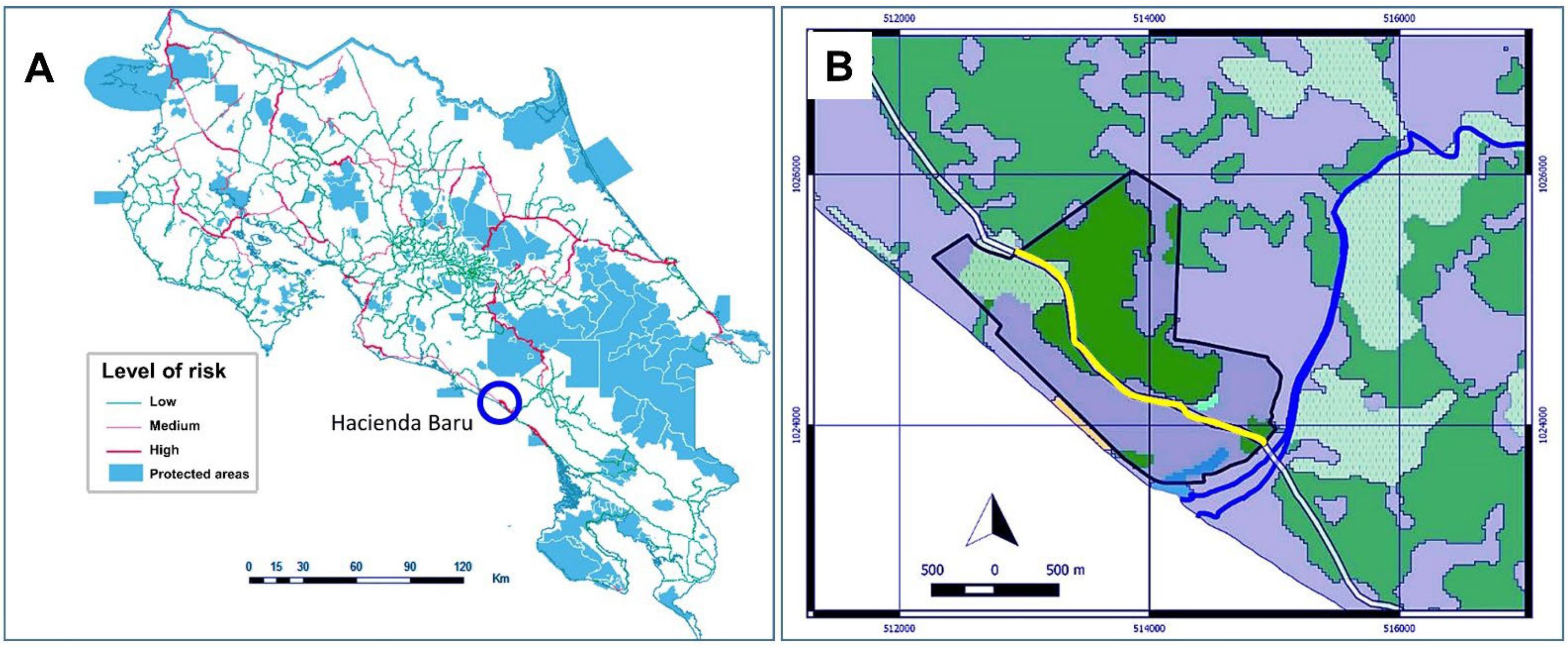
Figure 1. (A) Road system of Costa Rica with level of roadkill risk indicated in the key (red are areas of high roadkill risk) and blue are protected areas. Hacienda Barú National Wildlife Refuge is indicated by the blue circle. Adapted from [23]. (B) Section of Route 34 (in yellow) passing through Hacienda Baru National Wildlife Refuge (black boundary line) where the 23 wildlife-crossing structures were monitored with camera traps. Adapted with permission from [4].
Diversity 14 00665 g001
Figure 2. (A) Route 34 on the right of the photo looking north from Hacienda Baru National Wildlife Refuge. The compound of Hacienda Baru is encompassed by the yellow line. (B) Map of the wildlife crossings at Hacienda Barú National Wildlife Refuge showing the underpasses (tunnels) and overpasses (bridges) along Route 34, and the rope bridge along the service road in the inset. Map prepared by Amy Eppert.
Diversity 14 00665 g002
Figure 3. Construction of the wildlife-crossing structures at Hacienda Barú National Wildlife Refuge, circa 2010: (A,B) tunnels under construction and (C,D) bridges under construction. Source: Hacienda Barú National Wildlife Refuge.
Diversity 14 00665 g003
Figure 4. Percentage of mammalian species killed on National Route 34 based on the PRASCOSUR roadkill study. Adapted with permission from [27]. Graph prepared by Lily Bright.
Diversity 14 00665 g004
Figure 5. Mean number of roadkill recorded per each three-kilometer section of Route 34 during 1 January–1 July 2014, during the PRASCOSUR [27] study. Transect T14 (red) is the stretch of highway fronting Hacienda Barú National Wildlife Refuge. (A) All vertebrate animals; (B) all mammal species. Based on [4]. Key: T1 = Playa Tortuga, T2 = Ojochal, T3 = Piñuelas, T4 = Ballena, T5 = La Cusinga, T6 = Uvita, T7 = Rancho La Merced, T8 = Playa Hermosa, T9 = Punta Achiote, T10 = Cuna del Angel, T11 = La Macha, T12 = Dominicalito, T13 = Dominical, T14 = Hacienda Baru. Adapted with permission from [27]. Graph prepared by Emily Bohnet.
Diversity 14 00665 g005
Figure 6. Some of the 16 species of wildlife using the tunnels at Hacienda Barú National Wildlife Refuge, photographed with camera-trap videos: (A) agouti, (B) white-nosed coati, (C) northern raccoon, (D) ocelot male, (E) northern tamandua, and (F) collared peccary. Source: Hacienda Barú National Wildlife Refuge.
Diversity 14 00665 g006
Figure 7. Some of the nine species of wildlife using the hanging bridges at Hacienda Barú National Wildlife Refuge, photographed with camera trap still photos: (A) white-faced capuchin monkey, (B) white-nosed coati, (C) northern tamandua, (D) Mexican hairy porcupine, (E) wooly opossum, and (F) Hoffman’s two-toed sloth. Source: Hacienda Barú National Wildlife Refuge.
Diversity 14 00665 g007
Figure 8. Some of the seven species of wildlife using the hanging ropes at Hacienda Barú National Wildlife Refuge, photographed with camera-trap still photos: (A) white-faced capuchin monkey (B) brown three-toed sloth, (C) green iguana, and (D) variegated squirrel. Source: Hacienda Barú National Wildlife Refuge.
Diversity 14 00665 g008
Table 1. Species (common and scientific names) found for the PRASOCOSUR roadkill study [27] and Venegas study [4] of crossing structure use, and the use of tunnel, cable bridges and rope bridges described in this study. The “X” indicates the species was present as roadkill [27] or was recorded on camera traps using the crossing structure ([4], this study).
Species Common NameSpecies Scientific NamePRASCOSUR
Study [27]
Venegas Study [4]This Study
Large TunnelCable BridgesRope Bridges
Howler monkeyAlouatta palliataX
Brown-throated three-toed slothBradypus variegatusX XX
Central American woolly opossum Caluromys derbianus X
White-faced capuchin monkeyCebus capucinusX XXX
CoyoteCanis latransX
Hoffman’s two-toed slothCholoepus hoffmanni XX
Mexican hairy porcupineCoendou mexicanusX XX
Striped hog-nosed skunkConepatus semistriatusXXX
PacaCuniculus paca XX
Central American agoutiDasyprocta punctata XX
Nine-banded armadilloDasypus novemcinctusXXX
Common opossumDidelphis marsupialisXXXXX
TayraEira barbaraXXX
Greater grisonGalictis vittate X
Jaguarundi Herpailurus yagouaroundi X
OcelotLeopardus pardalis XX
White-nosed coatiNasua naricaXXXX
Collared peccaryPecari tajacuXXX
Gray four-eyed opossumPhilander opossumXXX
KinkajouPotos flavusX X
Northern raccoonProcyon lotorXXX
Crab-eating raccoonProcyon cancrivorusXXX
Variegated squirrel Sciurus variegatoidesX X
Southern spotted skunkSpilogale angustifronsX
Northern tamandua Tamandua mexicanaXXXXX
Publisher’s Note: MDPI stays neutral with regard to jurisdictional claims in published maps and institutional affiliations.