Article

Determining Plant Diversity within Interconnected Natural Habitat Remnants (Ecological Network) in an Agricultural Landscape: A Matter of Sampling Design?

1
Department of Life Sciences, University of Trieste, Via L. Giorgieri 10, 34127 Trieste, Italy
2
Department of Agricultural, Food, Environmental and Animal Sciences, University of Udine, Via delle Scienze 206, 33100 Udine, Italy
3
Department of Botany, Institute of Ecology and Earth Science, University of Tartu, Lai 40, 51005 Tartu, Estonia
*
Author to whom correspondence should be addressed.
Diversity 2022, 14(1), 12; https://doi.org/10.3390/d14010012
Submission received: 17 November 2021 / Revised: 13 December 2021 / Accepted: 23 December 2021 / Published: 27 December 2021
(This article belongs to the Special Issue 2021 Feature Papers by Diversity’s Editorial Board Members)

Abstract

:
In intensively used and human-modified landscapes, biodiversity is often confined to remnants of natural habitats. Thus, identifying ecological networks (ENs) necessary to connect these patches and maintain high levels of biodiversity, not only for conservation but also for the effective management of the landscape, is required. However, ENs are often defined without a clear a-priori evaluation of their biodiversity and are seldom even monitored after their establishment. The objective of this study was to determine the adequate number of replicates to effectively characterize biodiversity content of natural habitats within the nodes of an EN in north-eastern Italy, based on vascular plant diversity. Plant communities within habitat types of the EN’s nodes were sampled through a hierarchical sampling design, evaluating both species richness and compositional dissimilarity. We developed an integrated method, consisting of multivariate measures of precision (MultSE), rarefaction curves and diversity partitioning approaches, which was applied to estimate the minimum number of replicates needed to characterize plant communities within the EN, evaluating also how the proposed optimization in sampling size affected the estimations of the characteristics of habitat types and nodes of the EN. We observed that reducing the total sampled replicates by 85.5% resulted to sufficiently characterize plant diversity of the whole EN, and by 72.5% to exhaustively distinguish plant communities among habitat types. This integrated method helped to fill the gap regarding the data collection to monitor biodiversity content within existing ENs, considering temporal and economic resources. We therefore suggest the use of this quantitative approach, based on probabilistic sampling, to conduct pilot studies in the context of ENs design and monitoring, and in general for habitat monitoring.

1. Introduction

Biodiversity loss is one of the main concerns in the Anthropocene, happening at a faster rate than ever, driven by many factors such as land use change, habitat fragmentation, pollution, natural resources exploitation, climate change, biological invasion, and many others [1,2,3]. Although protected areas (PAs) were designed to face these problems through conservation actions focused on endangered target habitats and species, it is now clear that biodiversity protection should rely on a more efficient management of the anthropogenic surrounding landscapes and no longer be confined only to PAs [4,5,6]. Urgent actions to mitigate habitat loss and fragmentation are needed. These actions must be achieved through a management approach that coherently considers all the landscape components, integrating also information about functional traits of species and landscape structures through connectivity models [7]. In this context, the Ecological Network (EN) was established as a useful tool to provide an integrated protection of biodiversity also considering biotic interactions among species in an ecosystem [8]. ENs were described and used as tools for conservation planning that rely on the concept of ecological connectivity between the more natural portions of a landscape (so called “nodes” of the EN), with the final aim to limit the effects of fragmentation of habitat patches [9,10,11,12]. ENs were thought as a patch matrix model [13], a vision of landscape in which discrete homogeneous habitat patches, surrounded by a more or less inhospitable matrix, are connected in a network structure to support ecological connectivity at landscape scale [14]. Research concerning ENs have developed different approaches directed to assess both the structural connectivity, that is a property of the landscape and concerns the spatial pattern of habitat patches and is independent of the ecological characteristics of the species [15,16], and the functional connectivity, defined as the behavioral movement response of organisms towards habitat patches [17,18]. In this respect, many analytical tools were developed in recent decades such as least-cost modeling, circuit theory, and graph-theoretic methods, aiming at design connectivity models [14].
The concept of EN is increasingly accepted as an operational tool for protecting biodiversity, improving ecological connectivity, and sustainable development of landscapes [19,20,21,22]. Several studies have focused on the application of ENs, both from the theoretical and practical point of view, highlighting the complex interaction between structural and functional features of ENs, and the need for further research on the effects of their planning and implementation [14,23,24,25]. In particular, the definition of the EN follows often an approach oriented only to the structure of the network, while there is a lack of standards in EN projects (e.g., no clear objectives, no monitoring activities) to make them a suitable tool for biodiversity conservation [25,26,27]. Thus, it is essential to assess the spatial distribution of the habitats within the EN and to quantify their biodiversity content as they may be potentially altered due to anthropic activities of the surrounding matrix, or even by application of improper management of the nodes [28,29,30]. Moreover, the identification of the habitats suitable for a species should consider the plant communities that are fundamental to habitat type definition, adopted also in modern European classifications [31,32,33,34]. The term “habitat” has been used in various contexts with different meanings. In the context of EN, we refer to habitat as an assemblage of animals and plants, together with their abiotic environment, that contribute as patches of the network. Plant communities also have a key role in primary productivity, capturing that portion of solar energy that can support the life of all components of the biosphere, as well as in regulation of the nutrients’ cycle and in soil protection [35] and stand for a large part of biodiversity of landscapes.
In this light, a robust and replicable method to detect the biological and structural characteristics of plant communities within the ENs is needed. It should also aim at monitoring the distribution and biodiversity content of the habitat types. A robust methodological approach which is based on probabilistic sampling of plant communities is fundamental to estimate how suitable a sample is for seizing the species diversity and relative abundance, avoiding bias [36]. The adequacy of sampling methods able to reliably characterize ecological communities within a habitat have long been debated in literature (e.g., Yoccoz et al. [37], Balmford et al. [38], Del Vecchio et al. [39], Maccherini et al. [40]). One recently introduced approach which proved to be useful consists of evaluating multivariate differences in the composition of plant communities [41], using a measure of precision based on dissimilarity matrices called pseudo multivariate dissimilarity-based standard errors (MultSE), which allow for determination of sample-size adequacy within communities. The MultSE is the multivariate analog of the standard error and measures the variability in the position of the centroid in the space of a chosen dissimilarity measure under repeated sampling for a given sample size [41]. This measure of multivariate precision was recently used in the context of European habitats monitoring for costal sand dunes by Maccherini et al. [40], and it can represent a valid approach to estimating the optimal sample-size required to adequately characterize plant communities within habitats.
In this study, we provide an integrated method to determine the adequate number of replicates to effectively characterize biodiversity within habitat types (considered as EUNIS habitat types [33]) and nodes in an EN whose main novelty relies on the combination of (i) MultSE, (ii) rarefaction curves, and (iii) diversity partitioning approaches. Our main contribution is to provide a methodological framework for practitioners to support biodiversity data collection planning, in the EN design process or in the monitoring of existing ENs and PAs, as requested by the European Biodiversity Strategy for 2030 [42].
In an EN, modeled in the context of the regional landscape planning process at the regional level, we sampled 193 vegetation plots in 14 habitat types contained within 74 nodes, aiming at estimating how many replicates are sufficient (a) to distinguish and maintain the typification among different habitat types and (b) to gather data on species diversity and heterogeneity within the whole EN. We tested our framework on an EN in Friuli Venezia Giulia region (north-eastern Italy), which was developed in the context of the regional landscape planning project [43]. The sampled EN is composed of numerous PAs and biotopes, as well as several patches of semi-natural and natural habitats in an agricultural landscape matrix. These habitat types, forming the nodes of the EN, consist mainly of wetlands, linked to the presence of rivers and fens, which are well-known for their ecological role and for the high levels of biodiversity [44]. These environments are usually underrepresented in EN studies and the few studies concerning wetlands tend to give more weight to animal diversity instead of plant diversity [45].

2. Materials and Methods

2.1. Study Area and EN Model

This study was carried out in a local EN in the Friulian lowland (Friuli Venezia Giulia region, NE Italy; centroid coordinates: 45°48′13.4″ N–13°08′11.0″ E; Figure 1).
The study area has an extent of 298 km2 and is included in an agricultural context bounded by two river systems (Stella and Corno rivers, respectively). The landscape is characterized by a mixed mosaic of intensively and extensively cultivated areas, settlements, semi-natural (hedgerows and watercourses) and natural habitats (woodlands, shrubs, meadows and fens), including eight Natura 2000 Special Area of Conservation (Habitats Directive 92/43/EEC) and nine regional protected sites (biotopes), connecting mainly wetland habitat types.
The geology of the area is mainly composed of Quaternary sand sediments, silt sediments and silt-clay sediments generated by glacial fluvial transport during Pleistocene and by alluvial deposit during Holocene. The area is characterized by an average annual temperature of ca. 13 °C and an average annual rainfall between 1100 and 1400 mm.
In this intensively cultivated landscape, connectivity was mapped on a habitat-species based model (flora and fauna), developed at the local scale in the context of the regional landscape planning process [43]. The model is based on least-cost path analysis and graph theory used to obtain species-specific ENs which were later merged into the final composite multi-species network (Figure S1), where the nodes (natural habitats), corridors and stepping stones (links between natural habitats) were obtained for a set of 19 target species (10 animal species and 9 plant communities, assumed to be crucial for several plant species of conservation concern) to capture favorable conditions for biodiversity. Specifically, the EN was originally modeled from the habitat map of the region [46], using the habitat classification proposed by Poldini et al. [47] (see Table 1), and crossing costs for species were attributed by expert assessment and literature review data. However, for a more comparable interpretation and replicability of this study, the adopted habitat classification was converted according to the European Nature Information System (EUNIS, [33]) classification which has a one-to-one correspondence with the previous classification (Table 1). The term habitat is here understood as an assemblage of plants together with their abiotic environment. The EN is composed of 108 nodes and 17 different habitat types, for a total extent of 5900 ha of which 1700 ha represent nodes and 4200 ha ecological corridors.

2.2. Sampling Design and Data Collection within the EN

Among the nodes, we selected and sampled all the nodes larger than 1 ha. Purely aquatic habitat types (i.e., C1.14, C1.24, C2.27, EUNIS codes; see Table 1) within the nodes were not sampled, since they require completely different assumptions for connectivity than terrestrial ones. Ecological corridors were not sampled. Thus, the final dataset relies on 74 nodes and 14 habitat types. The adopted sampling design was hierarchical (Figure 1), where each habitat type was sampled within each node (that could contain more than one habitat type), proportionally to habitat extent within the node. The sampling density with respect to the habitat extent was chosen as follows: a squared plot of 100 m2 was randomly placed for a habitat area <5 ha, 2 plots for an area ≥5 and ≤10 ha and, finally, 3 plots for an area >10 ha. In total, 193 plots were randomly selected within the EN corresponding to an overall sampling density of 0.11 plot/ha. Occurrence and abundance (% visual cover estimation) of vascular plant species were recorded within each plot. Nomenclature and taxonomy of species followed Bartolucci et al. [48] for native species and Galasso et al. [49] for alien species. Data were collected during spring and summer 2019.

2.3. Data Analysis

Habitat types and nodes within the EN were analyzed in terms of species richness (alpha diversity) and compositional dissimilarity as a measure of species complementarity among sampling units (sensu Whittaker [50] defined as beta diversity). The latter was analyzed using the Bray–Curtis (BC) dissimilarity index [51]. This index is defined as the sum over the whole species of the ratio between the difference of abundance values and the sum of abundance values for each species, and it represents the vegetation plots pairwise differences using quantitative species abundance data. The BC dissimilarity index ranges between 0, when two plots share the same elements, to 1, when the two sampling units are totally different). First, we performed a preliminary analysis to evaluate statistical differences in species richness among habitat types and nodes using ANOVA test followed by Tukey post-hoc test (using the “multcomp” R package version 1.4-17, [52]) when significant. These differences represented our baseline diversity values characterizing the EN in terms of biodiversity and its variability among habitat types/nodes, given the maximum sampling effort available. Then, we characterized diversity patterns through sample-based rarefaction curves (RCs) using exact method and spatially explicit rarefaction curves (SERs, [53,54,55]), using the function available in “Rarefy” package (version 1.1) [56] and in “vegan” R package (version 2.5-7) [57]. We compared first the habitat-based curve and node-based curve to the rarefaction curve for the whole dataset (both RC and SER) and then the curves for each habitat (RCs and SERs) to the whole dataset curve (both RC and SER). Finally, we compared RC for each node with respect to the whole dataset RC. The difference between RC and SER somehow expresses the amount of spatial autocorrelation among sampling units, based on the spatial structure of the collected data and already proved to be effective in different habitat types [55,58].
Species richness patterns across different spatial scales (plot, habitat/node, whole EN) were also evaluated by means of additive partitioning techniques [59,60] using the “adipart” function in the “vegan” R package [57] and their significance was tested using a null model that permutes the original data matrix 999 times to assess deviation from random expectations.
Pseudo multivariate dissimilarity-based standard error (MultSE) was computed following the method described by Anderson and Santana-Garcon [41], and using the code and functions provided therein. MultSE (Equations (1) and (2)) is based on the chosen dissimilarity measure, thus providing a powerful tool to examine the relative precision of a sampling procedure. It is calculated as follows:
M u l t S E = V / n
where V is a multivariate measure of pseudo variance in the space of the chosen dissimilarity measure:
V = 1 ( n 1 ) i = 1 ( n 1 ) j = ( i + 1 ) n d i j 2 n
where n is the number of sampling units and d represents the squared distance between individual sampling points to their centroid, given a chosen dissimilarity measure.
To calculate MultSE, we first downweighted the abundance of the plant community matrix using a log (x + 1) transformation and then we computed the BC dissimilarity index. This was computed both for habitat types and habitat types aggregated within nodes, and then for the whole dataset. A double resampling scheme was used to generate means for each sample size and 95% confidence intervals; in particular the first was obtained from 10,000 permutations and the latter from 10,000 bias-adjusted bootstrap resamples. When the profile of MultSE in relation to the increasing sampling size reaches an asymptote, we can consider that sample size as an adequate number of replicates beyond which only small fluctuations of sampling precision can be observed. The point where the slope of MultSE profile changes, was estimated using R package “segmented” version 1.3-4 [61,62]. These were calculated only for the habitat types and for the whole dataset. The number of plots for each node profile was often not large enough to estimate breaking points.
To verify if and how the proposed reduction in sampling size affects diversity, we reduced the whole dataset adopting resampling strategies as suggested by the results of MultSE. In particular, the complete dataset was resampled both randomly and stratified by habitat types. The plots were resampled from the whole dataset, using the number of plots derived from MultSE estimation for the habitat types (999 random resamples) and for the whole EN (999 random resamples). These subsets of plots were then tested to investigate if there were significant differences in species richness between habitat types (only for habitat types resampling). Species diversity patterns across different scales (plot/habitat/whole EN and plot/node/whole EN) were evaluated both for the habitats resampled subset (HRS) and for the whole EN resampled subset (ENRS). Finally, the resulting statistics were compared with those of the original dataset to determine the effect in sampling reduction in the ability to discriminate among habitat types and EN nodes.

3. Results

Overall, 74 nodes of the EN were sampled, of which 56 were formed by a singular habitat and 18 by multiple habitat types. The most common habitat types within the nodes were G1.11 Riverine Salix woodland (present within 26 nodes, see Table 1 for more details on habitat types), F3.23 Tyrrhenian sub-Mediterranean deciduous thickets (19), G1.A1A Illyrian Quercus-Carpinus betulus forests (17), G1.41 Alnus swamp woods not on acid peat (14), E2.2 Low and medium altitude hay meadows (13), while the less common were F9.2 Salix carr and fen scrub (7), D4.11 Schoenus nigricans fens, E3.51 Molinia caerulea meadows and related communities, G1.223 Southeast European Fraxinus-Quercus-Alnus forests (5), D5.24 Fen Cladium mariscus beds (2), other habitat types were present only within a singular node. Most of these habitat types (11) were attributable to wetland habitat types and were present in 78% of the nodes, occupying 84% of the total extent of the EN’s nodes.
A total of 399 plant species were sampled in the EN, of which 42 were aliens and 20 were protected, rare or endemic species according to European, Italian, or Regional red lists. The most frequent native species were Rubus caesius (occurring in 126 plots), Rubus ulmifolius (118), Quercus robur (107), Hedera helix (106), Cornus sanguinea (104) and Salix alba (94). Concerning alien species, the most frequent were Platanus hispanica (61), Robinia pseudoacacia (33) and Potentilla indica (28). Finally, the most frequent protected species were Ruscus aculeatus (Habitat Directive 92/43/CEE Annex V, 18 occurrences) and Neottia ovata (CITES and (CE) N. 407/2009 Annex B, 8 occurrences).
The sampling activity, that aimed at verifying the biodiversity content of the EN, helped also to verify the correspondence between cartography and ground-data. Moreover, it permitted us to update the habitat attribution to a precise habitat type thanks to a greater level of detail and considering natural dynamism among plant communities (e.g., see Table 1 habitat types distinguished by the symbol +).
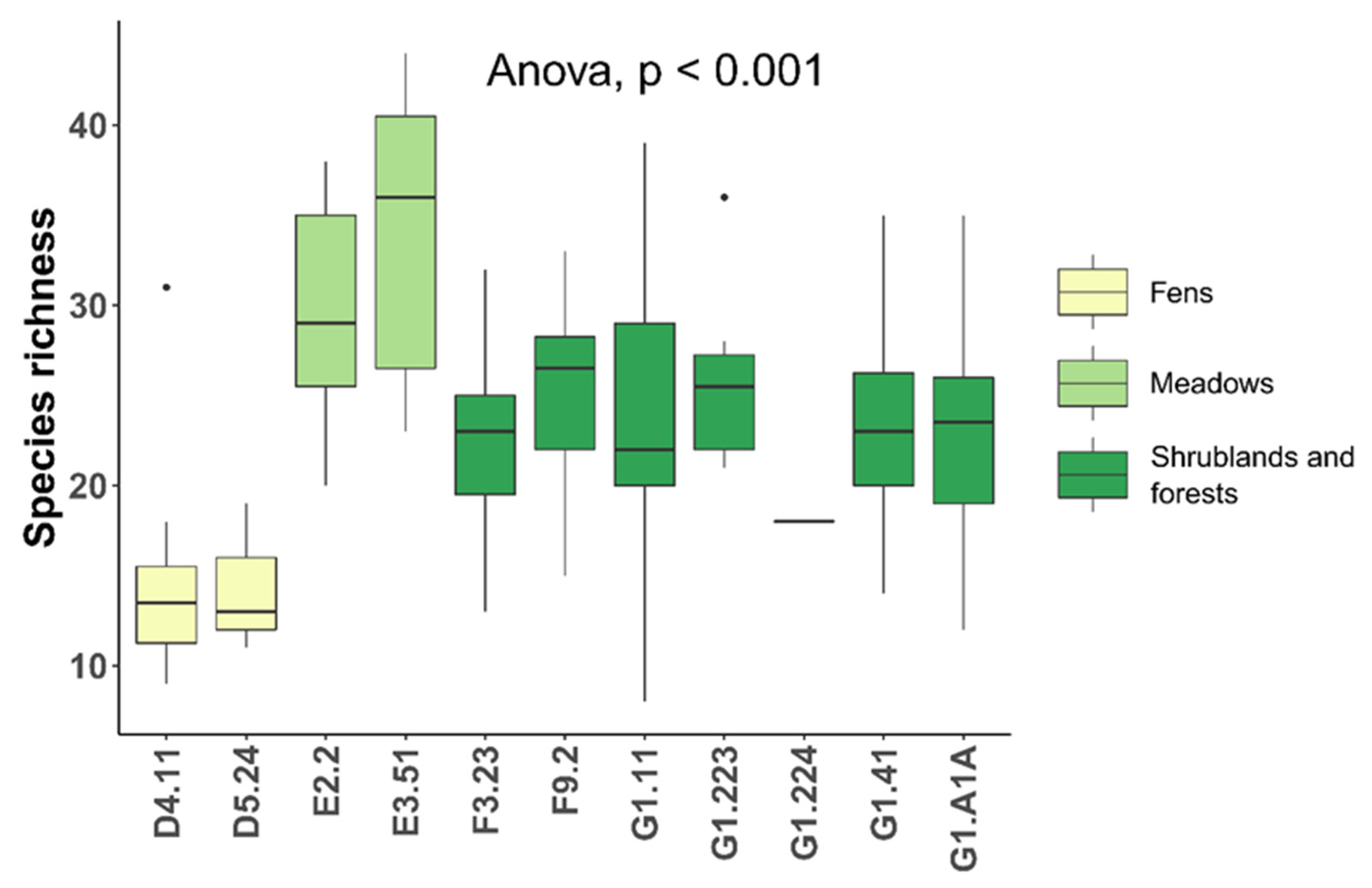
Concerning species richness calculated at the habitat level (Figure 2), the higher values were in meadows (31.3 ± 8.8 species), the lowest ones in fens (14.9 ± 5.3 species), while intermediate values were observed in shrublands and forests (23.3 ± 5.8 species). Species richness was significantly different among these 3 groups, but not within the groups. Conversely, no significant differences emerged for species richness between EN nodes.
Rarefaction curves (RCs, Figure S2) calculated from the whole dataset confirmed that spatially explicit rarefaction curve (SER) accumulated a lower number of species than RC and revealed that the habitat-based RC accumulated species less rapidly than the node-based RC and SER. RCs for habitat types (Figure S3) showed that none of the curves reached a plateau. A similar trend was observed also in the RCs for nodes (Figure S4).
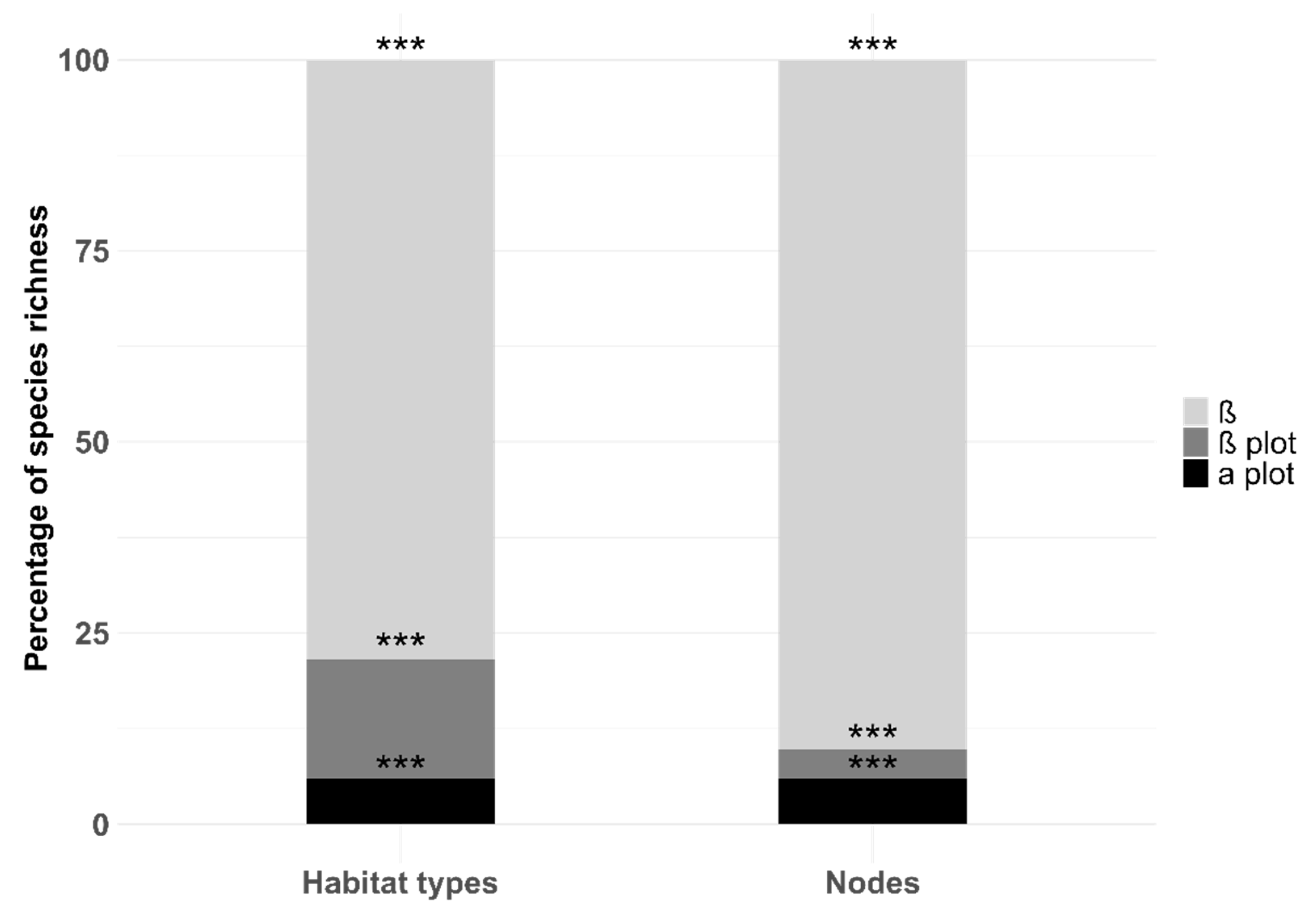
Additive partitioning (Figure 3) for habitat types showed how within habitat type diversity (i.e., the average inventory diversity) accounted for 15.61% of the total EN diversity and it was lower than between habitat type diversity (78.43% of total diversity). For nodes, this pattern was even more evident, with a diversity within nodes (3.84% of total diversity) lower than between them (90.2% of total EN diversity).
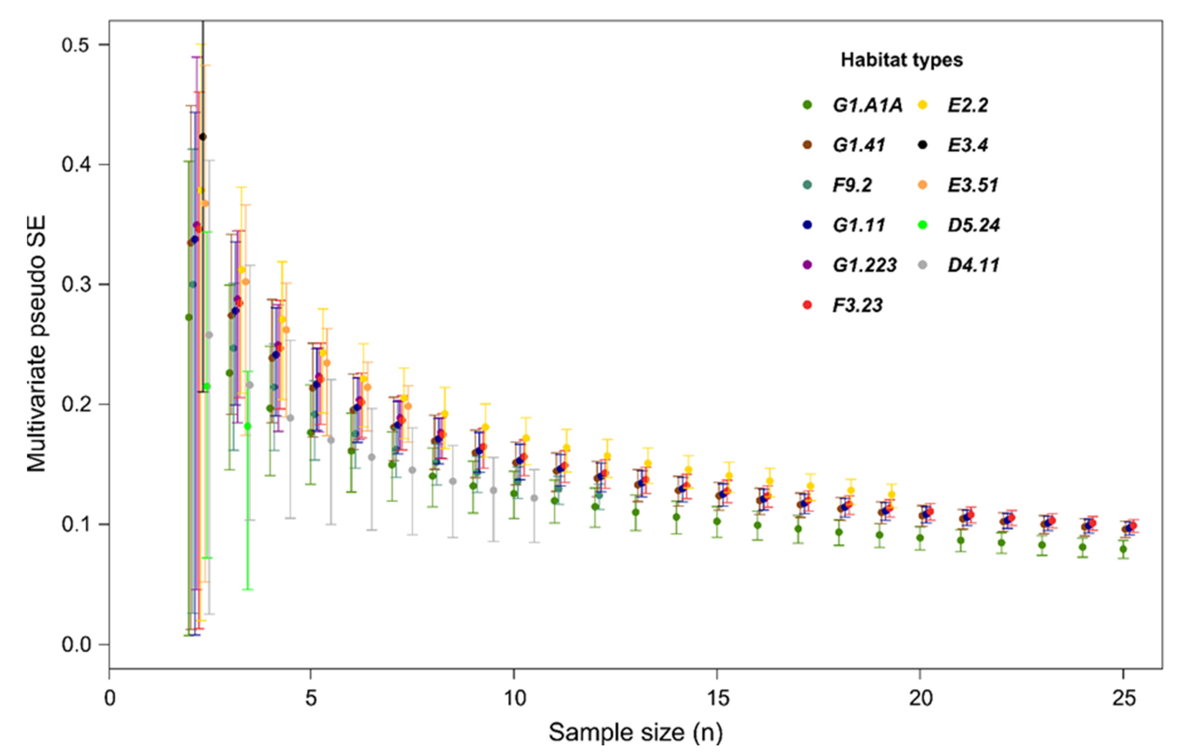
MultSE profiles in relation to sample size for each habitat type within the EN (Figure 4) flattened out between seven and ten plots depending on habitat type, a similar trend was observed also in the MultSE profiles of the nodes (Figure S5). The MultSE profile for the whole dataset (Figure S6) flattened out at around 25 plots.
Based on habitats’ MultSE profiles, the minimum number of replicates needed to characterize the main features of each habitat was reported in Table S1, while the minimum number of replicates needed for the whole EN was 27.77 ± 1.77 (mean ± SD) according to the point where the slope of MultSE profile changed.
In addition, our results proved to be robust when reducing the size of the dataset to the ones suggested by the previous analysis (i.e., 53 plots for HRS, 28 for ENRS) detecting similar patterns in terms of species richness and additive partitioning of diversity (Table 2 and Table 3).

4. Discussion

Sampling diversity of plant communities, in terms of species richness and composition, allowed us to verify and update the distribution of the habitat types within the nodes of the EN. In fact, the field survey can reach a higher level of detail than cartographic data, thus being able to capture and interpret the different aspects of plant mosaics and their dynamism over time, potentially caused by global change and/or anthropic pressure [63]. Moreover, this verification between ground and map data in EN planning should be required [25] and it should be undertaken independently of the cartographic reference checks, which are completed during map drafting. In fact, these incongruences between maps and the observed environment can be a limit in the planning and design phase of the EN and in the application of indexes for connectivity analysis, where weight evaluation of the nodes is requested (e.g., probability of connectivity index). Moreover, it highlights once again the need for verification and monitoring of the modeled EN once implemented. This issue is well known in literature, and Foltete et al. [45] recently highlighted the weakness of approaches based on landscape structure data, suggesting to not use landscape graphs in operational contexts without validating them beforehand with empirical data on species or communities.
As expected, the species richness and rarefaction curves for habitat types and nodes (Figure 2 and Figures S2–S4) described the high heterogeneity existing between nodes, in fact, the method used to identify the EN has been developed to cover the functional areas needed to host the highest number of different species [43], assuming that the species and habitat types used for modeling the EN stand as a proxy for many other species. Moreover, the SERs for habitat types (Figure S3) showed an increasing species richness going from moist or wet grasslands and fens (D4.11, D5.24, E3.4), to shrublands and forests (F3.23, F9.2, G1.A1A, G1.11, G1.223, G1.41) and meadows (E2.2, E3.51). A similar trend was found by De Simone et al. [64] studying patterns of biodiversity in cultivated landscapes, where meadows and woodlands proved to be hotspots of biodiversity. Furthermore, the habitat-based RC accumulated species less rapidly than the node-based RC (Figure S2) while the SER first displayed a trend similar to the node-based RC, and then to the habitat-based one. This feature indicated a higher similarity among habitat types in terms of species composition, than nodes. Nodes were also generally more extended than habitats and therefore they accumulated species more rapidly [65]. Additionally, some of the nodes were often composed by more habitat types, allowing for a faster accumulation of species.
These results pointed out that node-based RC accumulated more species than habitat-based RC, suggesting that a sampling design based on nodes is more efficient in capturing the EN heterogeneity: similar habitat types, sharing similar species composition and structure (e.g., shrublands and forests shared numerous species: Salix spp., Alnus glutinosa, Populus spp., Quercus robur, Fraxinus spp., etc.), include indeed a high redundant composition of species that can be characterized with fewer sampling units. This is further corroborated by additive partition of diversity (Figure 3), which showed as nodes were more diverse between them than habitat types themselves.
Regarding MultSE profiles, the number of plots required for characterizing habitat types ranged from 4 to 8 (Figure 4 and Table S1). Grassland habitat types needed fewer plots than woodland habitat types, due to the lower degree of habitat complexity. Probably the applied plot size was too small for forest habitat types due to the scale of the vegetation patchiness but, even though the plot size might not completely proper in every habitat type, a uniform plot size was needed for the aims of this work and for further research concerning the EN under study. The number of plots required for nodes ranged from two to ten (Figure S5), depending on the number of habitat types present within the node. It is interesting to note that if we consider the whole dataset (Figure S6), 28 replicates (14.51% of the original dataset) are sufficient to maintain the same level of heterogeneity of the network as observed with all the sampling units. Indeed, the additive partitioning of diversity for the reduced dataset, showed a minimum variation of α plot, β plot and β (Table 2) thus the overall signal for the whole EN remained comparable to the original. This suggests that sampling all the nodes of the EN leads to a redundancy in the data, if the aim is to point out an overall plant diversity contained within the EN.
Conversely, the approach that allows for distinguishing best among plant communities is the habitat-based sampling design. Indeed, when considering the HRS’ analysis (53 plots, 27.46% of the original dataset), we noticed that the significant difference between habitat composition remained constant (Table 3) and the partitioning of diversity underwent a slight variation (Table 2). In this case, the observed variation in the diversity partitioning was due to a lower redundancy of sampled species; in fact, oversampling habitat types that had many species in common (e.g., shrublands and forests) led to a lower diversity between habitat types (72.38% in the reduced dataset vs. 66.64% of the original dataset).
Considering the results in their totality, the best approach between habitat-based and node-based depends on the aims of the research: in our study case the habitat-based approach gave us important information both on the heterogeneity of the network and on habitat types’ structure and composition, but a node-based approach can be a valid alternative when time and resources are scarce and the aim is to point out an overall richness for the studied EN.
It is worth noting that our results give a general indication on the adequate sampling effort that can be applied in similar contexts. It should be highlighted that our EN is predominantly wetlands based, so more studies would be needed if applied to other habitat types (e.g., an EN based primarily on grasslands would probably need more plots). Moreover, the proposed methodology can be useful for monitoring the ENs over time, considering that ENs are never monitored after being implemented [25]. That is, starting with a sampling design proportional to the extent of the EN under study, it is possible to establish the minimum and sufficient number of sampling units to subsequently monitor diversity variation over time. Finally, our results on MultSE profiles, albeit applied in a completely different context, are consistent with previous studies [40,41], thus confirming it to be a useful statistic for assessing sample-size adequacy in studies of ecological communities.
Since ENs are often modeled on the basis of species-habitat interactions and designed based on graph theory [66,67], it is extremely important to join biological data in the graph’s early construction stage [44] to confirm the distribution of the habitat types in the area and their composition in terms of plant communities, as they are the primary component for habitat types determination [31,32,33,34] and the basis on which the interaction species-habitat are set up.
As already acknowledged in literature, it is not recommended to analyze plant communities by preferential sampling [68,69] which may lead to biased results, and for this reason the sampling design must be probabilistic and replicates independent, and it is essential to establish a measure of sampling adequacy to exhaustively distinguish different plant communities.
A final consideration regarding wetlands should be made. These environments are reported to be less studied in ENs’ literature [45] and they are known to be vulnerable ecosystems extremely important for the maintenance of biodiversity, as they are peculiar environments extremely rich in both plant and animal diversity. More than 78% of the habitat types within our EN were attributable to wetland habitat types and 4 of those resulted to be rich of rare, protected, or endemic species. In particular, Schoenus nigricans dominated fens (D4.11) presented seven species as well as Molinia caerulea meadows (E3.51), while Illyrian Quercus robur-Carpinus betulus forests (G1.A1A) and Alnus glutinosa swamp woods (G1.41), respectively, five and four species. This result confirms that these habitat types are particularly important for the conservation of biodiversity in this region [70,71,72,73,74] and should be paid particular attention.

5. Conclusions

In this study, we used an innovative integrated approach in order to estimate the adequate sample size to maintain the observed features of plant communities within the habitat types and nodes of the EN. This integrated method helped to fill the gaps regarding the collection of biodiversity data before the definition of an EN as well as the monitoring of biodiversity content within existing ENs.
The importance of validating ENs obtained through graph analysis, based on land cover maps and/or habitat maps, is widely known (e.g., Foltete et al. [45]). It is fundamental to optimize sampling design to enhance temporal and economic resources and define the minimum effort to adequately represent the biodiversity content of the networks.
Overall, our results gave us important information on the biodiversity conserved within the EN, the composition of plant communities and the sufficient sampling effort. One of the future developments of this study could be to distinguish between different ecological roles (e.g., Deák et al. [75]) of plant species within the habitat types for fine-tuning the methodology for applied practical conservation. In fact, the use of total biodiversity in our models is perfect for testing the integrated method but, in practical conservation planning, distinguishing between different ecological roles would be better. However, this study represents a novel approach to be applied in the context of designing and monitoring ENs, and thus more tests are needed to validate its suitability in different habitat types and organisms. In addition, we would recommend the use of this approach for conducting pilot studies on ENs, both for designing and monitoring, aiming at optimizing resources and in general for habitat monitoring.

Supplementary Materials

The following are available online at https://www.mdpi.com/article/10.3390/d14010012/s1, Figure S1: Flow chart of the main steps applied to model the multi-species Ecological Network: starting from a map of the habitat types of the study area and combining it with a table of costs (time and effort to travel through an environment) it was obtained a map of costs for all 10 animal species and 9 plant communities (habitats) present in the landscape. From the overlay of all species-specific networks the multi-species ecological network was obtained as the sum of all identified elements. Figure S2: Spatially explicit rarefaction curve (SER, blue dashed line), traditional rarefaction curve (RC, black dotted line), habitat-based rarefaction curve (red solid line) and node-based rarefaction curve (green solid line) calculated from the whole dataset. Figure S3: Spatially explicit rarefaction curves (SERs, dashed lines) and traditional rarefaction curves (RCs, solid lines) calculated for each habitat of the ecological network. The black solid line represents the RC calculated from the whole dataset, Figure S4: Classic rarefaction curves (RCs) calculated for each node of ecological network. The black dashed line represents the RC calculated from the whole dataset, Figure S5: MultSE profile based on Bray–Curtis dissimilarity for each node within the ecological network, Figure S6: MultSE profile based on Bray–Curtis dissimilarity for the whole dataset within the ecological network, Table S1: Estimated sample size for each habitat based on the slope change in the linear relation between MultSE and sample size. The value could not be estimated in habitat types with 3 or less replicates (NA = Not assessed, see main text).

Author Contributions

Conceptualization, G.B. and M.S.; methodology, E.T., G.B. and M.S.; formal analysis, F.L. and E.T.; data curation, F.L. and F.B.; writing—original draft preparation, F.L.; writing—review and editing, G.B., M.S., E.T. and F.B.; supervision, G.B. and M.S. All authors have read and agreed to the published version of the manuscript.

Funding

This research received no external funding.

Institutional Review Board Statement

Not applicable.

Informed Consent Statement

Not applicable.

Data Availability Statement

All data are available on request.

Acknowledgments

We would like to thank two anonymous reviewers for providing valuable advice to improve the final version of the article. In addition, we would also like to thank the handling editor.

Conflicts of Interest

The authors declare no conflict of interest.

References

  1. Landi, P.; Minoarivelo, H.O.; Brännström, Å.; Hui, C.; Dieckmann, U. Complexity and stability of ecological networks: A review of the theory. Popul. Ecol. 2018, 60, 319–345. [Google Scholar] [CrossRef]
  2. IPBES. Summary For Policymakers of the Global Assessment Report on Biodiversity and Ecosystem Services of the Intergovernmental Science-Policy Platform on Biodiversity and Ecosystem Services; Díaz, S., Settele, J., Brondízio, E.S., Ngo, H.T., Guèze, M., Agard, J., Arneth, A., Balvanera, P., Brauman, K.A., Butchart, S.H.M., et al., Eds.; IPBES: Bonn, Germany, 2019; p. 56. [Google Scholar] [CrossRef]
  3. EEA. State of Nature in the EU Report European Environment Agency 2020. State of Nature in the EU. Results from Reporting under the Nature Directives 2013–2018; Publication office of European Unions: Luxembourg, 2020; p. 142. ISBN 978-92-9480-259-0. [Google Scholar] [CrossRef]
  4. UN (United Nation). Transforming our World: The 2030 Agenda for Sustainable Development, A/RES/70/L.1. Resolution Adopted by the General Assembly; United Nations: New York, NY, USA, 2015; Available online: https://sustainabledevelopment.un.org/post2015/transformingourworld/publication (accessed on 12 November 2021).
  5. UN (United Nations). Sustainable Development Goals; United Nations: New York, NY, USA, 2015; Available online: http://www.un.org/sustainabledevelopment/sustainable-development-goals/ (accessed on 12 November 2021).
  6. European Commission. Communication from the Commission to the European Parliament, the Council, the European Economic and Social Committee and the Committee of the Regions EU Biodiversity Strategy for 2030 Bringing Nature Back into Our Lives COM/2020/380 Final 20.5.2020 Brussels 2020. Available online: https://eur-lex.europa.eu/legal-content/EN/TXT/?uri=CELEX:52020DC0380 (accessed on 16 November 2021).
  7. Cushman, S.A.; McRae, B.; Adriaensen, F.; Beier, P.; Shirley, M.; Zeller, K. Biological corridors and connectivity. In Key Topics in Conservation Biology 2; Macdonald, D.W., Willis, K.J., Eds.; Wiley-Blackwell: Hoboken, NJ, USA, 2013; pp. 384–404. [Google Scholar]
  8. Pascual, M.; Dunne, J. Ecological Networks: Linking Structure to Dynamics in Food Webs; Oxford University Press: New York, NY, USA, 2006. [Google Scholar]
  9. Fahrig, L. Effects of habitat fragmentation on biodiversity. Annu. Rev. Ecol. Evol. Syst. 2003, 34, 487–515. [Google Scholar] [CrossRef] [Green Version]
  10. Battisti, C. Frammentazione Ambientale Connettività Reti Ecologiche: Un Contributo Teorico E Metodologico Con Particolare Riferimento Alla Fauna Selvatica; Provincia di Roma Assessorato alle Politiche Agricole, Ambientali e Protezione Civile: Rome, Italy, 2004. (In French) [Google Scholar]
  11. Biondi, E.; Nanni, L. Geosigmeti, Unità Di Paesaggio E Reti Ecologiche. In Identificazione E Cambiamenti Nel Paesaggio Contemporaneo; Blasi, C., Paolella, A., Eds.; Atti del Terzo Congresso IAED: Roma, Italy, 2005; pp. 134–140. [Google Scholar]
  12. Rosati, L.; Fipaldini, M.; Marignani, M.; Blasi, C. Effects of fragmentation on vascular plant diversity in a Mediterranean forest archipelago. Plant. Biosyst. 2010, 144, 38–46. [Google Scholar] [CrossRef]
  13. Forman, R.T.T. Land Mosaics; Cambridge University Press: Cambridge, UK, 1995. [Google Scholar]
  14. Foltête, J.C. How ecological networks could benefit from landscape graphs: A response to the paper by Spartaco Gippoliti and Corrado Battisti. Land Use Policy 2019, 80, 391–394. [Google Scholar] [CrossRef]
  15. Tischendorf, L.; Fahrig, L. On the usage and measurement of landscape connectivity. Oikos 2000, 90, 7–19. [Google Scholar] [CrossRef] [Green Version]
  16. Taylor, P.D.; Fahrig, L.; With, K.A. Landscape connectivity: A return to the basics. In Connectivity Conservation; Cambridge University Press: Cambridge, UK, 2006. [Google Scholar]
  17. Taylor, P.D.; Fahrig, L.; Henein, K.; Merriam, G. Connectivity is a vital element of landscape structure. Oikos 1993, 68, 571–573. [Google Scholar] [CrossRef] [Green Version]
  18. LaPoint, S.; Balkenhol, N.; Hale, J.; Sadler, J.; van Der Ree, R. Ecological connectivity research in urban areas. Funct. Ecol. 2015, 29, 868–878. [Google Scholar] [CrossRef]
  19. Damschen, E.I. Landscape Corridors. In Encyclopedia of Biodiversity, 2nd ed.; Levin, S.A., Ed.; Academic Press: Cambridge, MA, USA, 2013; pp. 467–475. [Google Scholar] [CrossRef]
  20. De Montis, A.; Caschili, S.; Mulas, M.; Modica, G.; Ganciu, A.; Bardi, A.; Ledda, A.; Dessena, L.; Laudari, L.; Fichera, C.R. Urban–rural ecological networks for landscape planning. Land Use Policy 2016, 50, 312–327. [Google Scholar] [CrossRef]
  21. Keeley, A.T.H.; Ackerly, D.D.; Cameron, D.R.; Heller, N.E.; Huber, P.R.; Schloss, C.A.; Thorne, J.H.; Merenlender, A.M. New concepts, Models, and assessments of climate-wise connectivity. Environ. Res. Lett. 2018, 13, 073002. [Google Scholar] [CrossRef]
  22. Xu, H.; Plieninger, T.; Primdahl, J. A systematic comparison of cultural and ecological landscape corridors in Europe. Land 2019, 8, 41. [Google Scholar] [CrossRef] [Green Version]
  23. Battisti, C. Ecological network planning—From paradigms to design and back: A cautionary note. J. Land Use Sci. 2013, 8, 215–223. [Google Scholar] [CrossRef]
  24. Boitani, L.; Strand, O.; Herfindal, I.; Panzacchi, M.; St Clair, C.C.; van Moorter, B.; Saerens, M.; Kivimaki, I. Predicting the continuum between corridors and barriers to animal movements using step selection functions and randomized shortest paths. J. Anim. Ecol. 2015, 85, 32–42. [Google Scholar] [CrossRef] [Green Version]
  25. Gippoliti, S.; Battisti, C. More cool than tool: Equivoques, Conceptual traps and weaknesses of ecological networks in environmental planning and conservation. Land Use Policy 2017, 68, 686–691. [Google Scholar] [CrossRef]
  26. Kareksela, S.; Moilanen, A.; Tuominen, S.; Kotiaho, J.S. Use of inverse spatial conservation prioritization to avoid biological diversity loss outside protected areas: Inverse spatial conservation prioritization. Conserv. Biol. 2013, 27, 1294–1303. [Google Scholar] [CrossRef] [PubMed]
  27. Jalkanen, J.; Toivonen, T.; Moilanen, A. Identification of ecological networks for land-use planning with spatial conservation prioritization. Landscape Ecol. 2020, 35, 353–371. [Google Scholar] [CrossRef] [Green Version]
  28. Brooks, T.M.; Mittermeier, R.A.; Mittermeier, C.G.; da Fonseca, G.A.B.; Rylands, A.B.; Konstant, W.R.; Flick, P.; Pilgrim, J.; Oldfield, S.; Magin, G.; et al. Habitat loss and extinction in the hotspots of biodiversity. Conserv. Biol. 2002, 16, 909–923. [Google Scholar] [CrossRef] [Green Version]
  29. Wiegand, T.; Revilla, E.; Moloney, K.A. Effects of habitat loss and fragmentation on population dynamics. Conserv. Biol. 2005, 19, 108–121. [Google Scholar] [CrossRef]
  30. Thiele, J.; Kellner, S.; Buchholz, S.; Schirmel, J. Connectivity or area: What drives plant species richness in habitat corridors? Landscape Ecol. 2018, 33, 173–181. [Google Scholar] [CrossRef]
  31. Devillers, P.; Devillers-Terschuren, J.; Ledant, J.P. CORINE Biotopes Manual. Habitats of the European Community; Data Specifications—Part 2; EUR 12587/3 EN; European Commission: Luxembourg, 1991. [Google Scholar]
  32. Devillers, P.; Devillers-Terschuren, J. A Classification of Palaearctic Habitats; Nature and Environment, No 78; Council of Europe: Strasbourg, France, 1996. [Google Scholar]
  33. Davies, C.E.; Moss, D.; Hill, M.O. EUNIS Habitat Classification Revised 2004; Report to the European Topic Centre on Nature Protection and Biodiversity; European Environment Agency: Copenhagen, Denmark, 2004. [Google Scholar]
  34. European Commission. Interpretation Manual of European Union Habitats; EUR 28, April 2013, DG Environment, Nature ENV B.; European Commission: Luxembourg, 2013; p. 144. [Google Scholar]
  35. Lieth, H. Primary production: Terrestrial ecosystems. Hum. Ecol. 1973, 1, 303–332. [Google Scholar] [CrossRef]
  36. Cao, Y.; Larsen, D.P.; Hughes, R.M.; Angermeier, P.L.; Patton, T.M. Sampling effort affects multivariate comparisons of stream assemblages. J. N. Am. Benthol. Soc. 2002, 21, 701–714. [Google Scholar] [CrossRef] [Green Version]
  37. Yoccoz, N.G.; Nichols, J.D.; Boulinier, T. Monitoring of biological diversity in space and time. Trends Ecol. Evol. 2001, 16, 446–453. [Google Scholar] [CrossRef]
  38. Balmford, A.; Green, R.E.; Jenkins, M. Measuring the changing state of nature. Trends Ecol. Evol. 2003, 18, 326–330. [Google Scholar] [CrossRef]
  39. Del Vecchio, S.; Fantinato, E.; Silan, G.; Buffa, G. Trade-offs between sampling effort and data quality in habitat monitoring. Biodivers. Conserv. 2019, 28, 55–73. [Google Scholar] [CrossRef] [Green Version]
  40. Maccherini, S.; Bacaro, G.; Tordoni, E.; Bertacchi, A.; Castagnini, P.; Foggi, B.; Gennai, M.; Mugnai, M.; Sarmati, S.; Angiolini, C. Enough is enough? Searching for the optimal sample size to monitor european habitats: A case study from coastal sand dunes. Diversity 2020, 12, 138. [Google Scholar] [CrossRef] [Green Version]
  41. Anderson, M.J.; Santana-Garcon, J. Measures of precision for dissimilarity-based multivariate analysis of ecological communities. Ecol. Lett. 2015, 18, 66–73. [Google Scholar] [CrossRef] [PubMed] [Green Version]
  42. Directorate-General for Environment. EU Biodiversity Strategy for 2030: Bringing Nature Back into Our Lives; European Commission: Luxembourg, 2020. [Google Scholar]
  43. Sigura, M.; Boscutti, F.; Buccheri, M.; Dorigo, L.; Glerean, P.; Lapini, L. La rel dei paesaggi di pianura, Di area montana e urbanizzati. Piano Paesaggistico regionale del Friuli-Venezia Giulia (Parte Strategica) E1-allegato alla scheda di RER. Regione Friuli-Venezia Giulia. 2017. Available online: http://www.regione.fvg.it/rafvg/cms/RAFVG/ambiente-territorio/pianificazione-gestione-territorio/FOGLIA21/#id9 (accessed on 12 November 2021).
  44. Liccari, F.; Castello, M.; Poldini, L.; Altobelli, A.; Tordoni, E.; Sigura, M.; Bacaro, G. Do habitats show a different invasibility pattern by alien plant species? A test on a wetland protected area. Diversity 2020, 12, 267. [Google Scholar] [CrossRef]
  45. Foltête, J.C.; Savary, P.; Clauzel, C.; Bourgeois, M.; Girardet, X.; Sahraoui, Y.; Vuidel, G.; Garnier, S. Coupling landscape graph modeling and biological data: A review. Landscape Ecol. 2020, 35, 1035–1052. [Google Scholar] [CrossRef]
  46. ISPRA. La Carta della Natura della Regione Friuli-Venezia Giulia (Aggiornamento 2017). Available online: https://www.isprambiente.gov.it/it/servizi/sistema-carta-della-natura/carta-della-natura-alla-scala-1-50.000/la-carta-della-natura-della-regione-friuli-venezia-giulia-aggiornamento-2017 (accessed on 12 November 2021).
  47. Poldini, L.; Oriolo, G.; Vidali, M.; Tomasella, M.; Stoch, F.; Orel, G. Manuale degli habitat del Friuli-Venezia Giulia. Strumento a Supporto della Valutazione D’impatto Ambientale (VIA), Ambientale Strategica (VAS) e D’incidenza Ecologica (VIEc). Regione Autonoma Friuli-Venezia Giulia—Direz. Centrale Ambiente e Lavori Pubblici—Servizio Valutazione Impatto Ambientale, Univ. Studi Trieste Dipart. Biologia. 2006. Available online: http://www.regione.fvg.it/ambiente/manuale/home.htm (accessed on 12 November 2021).
  48. Bartolucci, F.; Peruzzi, L.; Galasso, G.; Albano, A.; Alessandrini, A.; Ardenghi, N.M.G.; Astuti, G.; Bacchetta, G.; Ballelli, S.; Banfi, E.; et al. An updated checklist of the vascular flora native to Italy. Plant. Biosyst. 2018, 152, 179–303. [Google Scholar] [CrossRef]
  49. Galasso, G.; Conti, F.; Peruzzi, L.; Ardenghi, N.M.G.; Banfi, E.; Celesti-Grapow, L.; Albano, A.; Alessandrini, A.; Bacchetta, G.; Ballelli, S.; et al. An updated checklist of the vascular flora alien to Italy. Plant. Biosyst. 2018, 152, 556–592. [Google Scholar] [CrossRef]
  50. Whittaker, R. Evolution and measurement of species diversity. Taxon 1972, 21, 213–215. [Google Scholar] [CrossRef] [Green Version]
  51. Bray, J.R.; Curtis, J.T. An ordination of the upland forest communities of Southern Wisconsin. Ecol. Monogr. 1957, 27, 325–349. [Google Scholar] [CrossRef]
  52. Hothorn, T.; Bretz, F.; Westfall, P.; Heiberger, R.M. Multcomp: Simultaneous Inference in General Parametric Models. R Package. 2008. Available online: http://CRAN.R-project.org (accessed on 12 November 2021).
  53. Chiarucci, A.; Bacaro, G.; Rocchini, D.; Ricotta, C.; Palmer, M.; Scheiner, S. Spatially constrained rarefaction: Incorporating the autocorrelated structure of biological communities into sample-based rarefaction. Commun. Ecol. 2009, 10, 209–214. [Google Scholar] [CrossRef]
  54. Bacaro, G.; Rocchini, D.; Ghisla, A.; Marcantonio, M.; Neteler, M.; Chiarucci, A. The spatial domain matters: Spatially constrained species rarefaction in a Free and Open Source environment. Ecol. Complex. 2012, 12, 63–69. [Google Scholar] [CrossRef]
  55. Bacaro, G.; Altobelli, A.; Cameletti, M.; Ciccarelli, D.; Martellos, S.; Palmer, M.W.; Ricotta, C.; Rocchini, D.; Scheiner, S.M.; Tordoni, E.; et al. Incorporating spatial autocorrelation in rarefaction methods: Implications for ecologists and conservation biologists. Ecol. Indic. 2016, 69, 233–238. [Google Scholar] [CrossRef] [Green Version]
  56. Thouverai, E.; Pavoine, S.; Tordoni, E.; Rocchini, D.; Ricotta, C.; Chiarucci, A.; Bacaro, G. Rarefy. R Package Version 1.0.0. 2020. Available online: http://CRAN.R-project.org (accessed on 12 November 2021).
  57. Oksanen, J.; Blanchet, G.F.; Friendly, M.; Kindt, R.; Legendre, P.; McGlinn, D.; Minchin, P.R.; O’Hara, R.B.; Simpson, G.L.; Solymos, P.; et al. Vegan: Community Ecology Package. R package version 2.5-6. 2019. Available online: https://CRAN.R-project.org/package=vegan (accessed on 12 November 2021).
  58. Tordoni, E.; Napolitano, R.; Maccherini, S.; Da Re, D.; Bacaro, G. Ecological drivers of plant diversity patterns in remnants coastal sand dune ecosystems along the northern Adriatic coastline. Ecol. Res. 2018, 33, 1157–1168. [Google Scholar] [CrossRef]
  59. Lande, R. Statistics and partitioning of species diversity, and similarity among multiple communities. Oikos 1996, 76, 5–13. [Google Scholar] [CrossRef]
  60. Crist, T.O.; Veech, J.A.; Gering, J.C.; Summerville, K.S. Partitioning species diversity across landscapes and regions: A hierarchical analysis of α, β, and γ-diversity. Am. Nat. 2003, 162, 734–743. [Google Scholar] [CrossRef] [PubMed] [Green Version]
  61. Muggeo, V.M.R. Estimating regression models with unknown break-points. Stat. Med. 2003, 22, 3055–3071. [Google Scholar] [CrossRef] [PubMed]
  62. Muggeo, V.M.R. Segmented: An R package to fit regression models with broken-line relationships. R News 2008, 8, 20–25. [Google Scholar]
  63. Franklin, J.; Serra-Diaz, J.M.; Syphard, A.D.; Regan, H.M. Global change and terrestrial plant community dynamics. Proc. Natl. Acad. Sci. USA 2016, 113, 3725–3734. [Google Scholar] [CrossRef] [PubMed] [Green Version]
  64. De Simone, S.; Sigura, M.; Boscutti, F. Patterns of biodiversity and habitat sensitivity in agricultural landscapes. J. Environ. Plan. Manag. 2016, 60, 1173–1192. [Google Scholar] [CrossRef]
  65. Arrhenius, O. Species and area. J. Ecol. 1921, 9, 95–99. [Google Scholar] [CrossRef] [Green Version]
  66. Urban, D.L.; Minor, E.S.; Treml, E.A.; Schick, R.S. Graph models of land mosaics. Ecol. Lett. 2009, 12, 260–273. [Google Scholar] [CrossRef] [PubMed]
  67. Galpern, P.; Manseau, M.; Fall, A. Patch-based graphs of landscape connectivity: A guide to construction, analysis and application for conservation. Biol. Conserv. 2011, 144, 44–55. [Google Scholar] [CrossRef]
  68. Diekmann, M.; Kühne, A.; Isermann, M. Random vs non-random sampling: Effects on patterns of species abundance, species richness and vegetation-environment relationships. Folia Geobot. 2007, 42, 179. [Google Scholar] [CrossRef]
  69. Lájer, K. Statistical tests as inappropriate tools for data analysis performed on non-random samples of plant communities. Folia Geobot. 2007, 42, 115–122. [Google Scholar] [CrossRef]
  70. Poldini, L.; Oriolo, G. Alcune entità nuove e neglette per la flora italiana. Inf. Bot. Ital. 2002, 34, 105–114. [Google Scholar]
  71. Wassen, M.J.; Venterink, H.O.; Lapshina, E.D.; Tanneberger, F. Endangered plants persist under phosphorus limitation. Nature 2005, 437, 547–550. [Google Scholar] [CrossRef]
  72. Dybkjær, J.B.; Baattrup-Pedersen, A.; Kronvang, B.; Thodsen, H. Diversity and distribution of riparian plant communities in relation to stream size and eutrophication. J. Environ. Qual. 2012, 41, 348–354. [Google Scholar] [CrossRef] [Green Version]
  73. Natlandsmyr, B.; Hjelle, K.L. Long-term vegetation dynamics and land-use history: Providing a baseline for conservation strategies in protected Alnus glutinosa swamp woodlands. For. Ecol. Manag. 2016, 372, 78–92. [Google Scholar] [CrossRef] [Green Version]
  74. Della Longa, G.; Boscutti, F.; Marini, L.; Alberti, G. Coppicing and plant diversity in a lowland wood remnant in North–East Italy. Plant. Biosyst. 2020, 154, 173–180. [Google Scholar] [CrossRef]
  75. Deák, B.; Rádai, Z.; Lukács, K.; Kelemen, A.; Kiss, R.; Bátori, Z.; Kiss, P.J.; Valkó, O. Fragmented dry grasslands preserve unique components of plant species and phylogenetic diversity in agricultural landscapes. Biodivers. Conserv. 2020, 29, 4091–4110. [Google Scholar] [CrossRef]
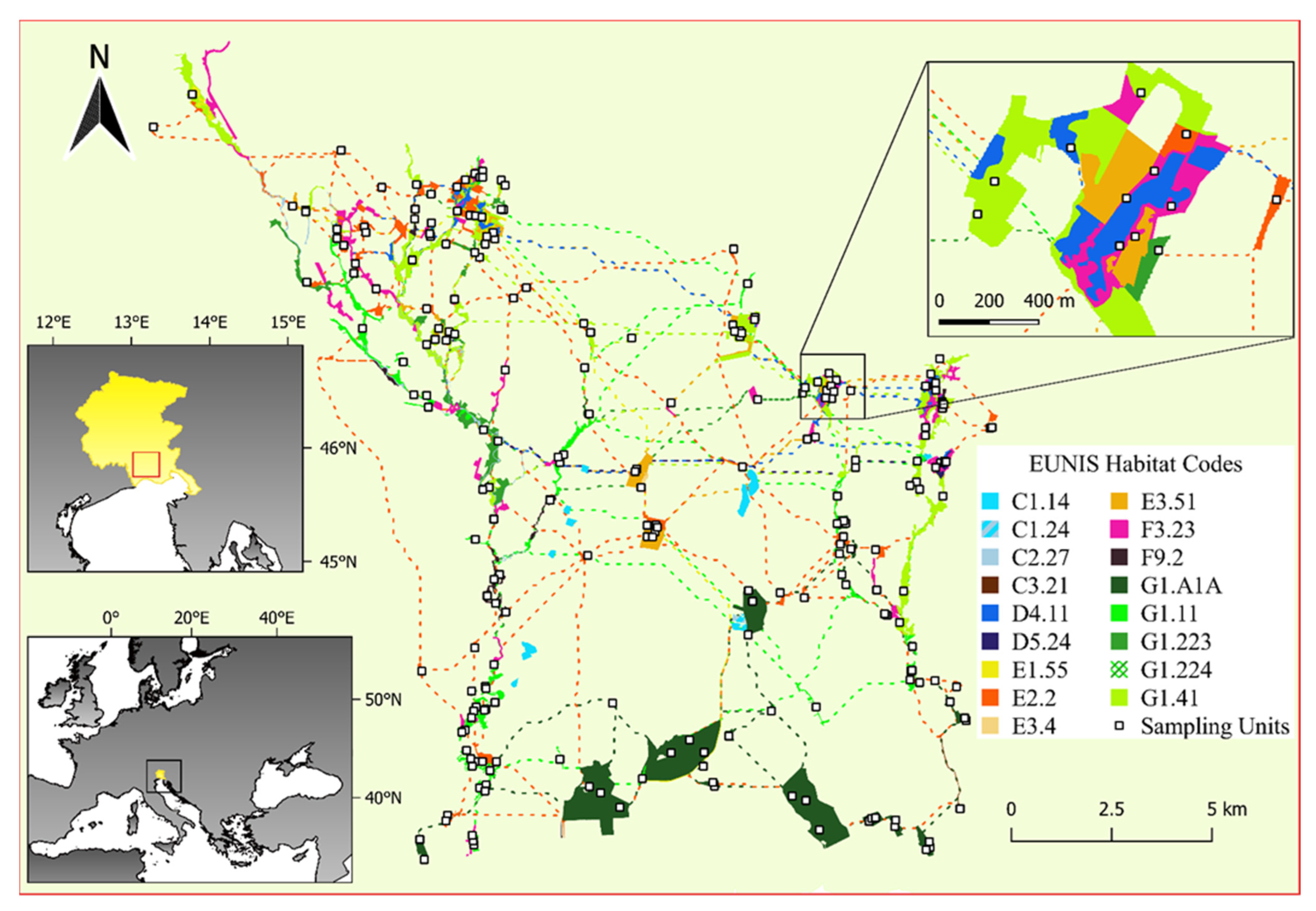
Figure 1. Study area location (Friuli Venezia Giulia region is represented in yellow) and ecological network representation (all the nodes of the EN are shown, including aquatic and smaller than 1 ha nodes). EUNIS Habitat Codes are as follows: C1.14 Charophyte submerged carpets in oligotrophic water bodies; C1.24 Rooted floating vegetation of mesotrophic water bodies; C2.27 Mesotrophic vegetation of fast flowing streams; C3.21 Phragmites australis beds; D4.11 Schoenus nigricans fens; D5.24 Fen Cladium mariscus beds; E1.55 Eastern sub-Mediterranean dry grassland; E2.2 Low and medium altitude hay meadows; E3.4 Moist or wet eutrophic and mesotrophic grassland; E3.51 Molinia caerulea meadows and related communities; F3.23 Tyrrhenian sub-Mediterranean deciduous thickets; F9.2 Salix carr and fen scrub; G1.A1A Illyrian Quercus-Carpinus betulus forests; G1.11 Riverine Salix woodland; G1.223 Southeast European Fraxinus-Quercus-Alnus forests; G1.224 Po Quercus-Fraxinus-Alnus forests; G1.41 Alnus swamp woods not on acid peat. Colored lines and patches are corridors and nodes of the network, representing different habitat types and species-specific networks. An example of the hierarchical sampling design in which each node was sampled stratified by habitat type proportionally to habitat extent within the node is showed.
Diversity 14 00012 g001
Figure 2. Species richness in habitat types and ANOVA resulting p-value. The color scale identifies the 3 groups with significant differences resulting from ANOVA post-hoc analysis (α < 0.05): fens (light yellow), meadows (light green) and shrublands and forests (green).
Diversity 14 00012 g002
Figure 3. Additive partitioning of diversity across different scales: within each plot (α plot), within each habitat type or node (β plot) and between habitat types or nodes (β). Asterisks indicate a significant difference from random expectations resulting from a null model (*** p < 0.001).
Diversity 14 00012 g003
Figure 4. MultSE profile based on Bray–Curtis dissimilarity for each habitat within the ecological network. The white space on the left is due to a MultSE higher than 0.5 in the first plots.
Diversity 14 00012 g004
Table 1. Habitat codes of the area according to Poldini et al. [47] and correspondence with EU and EUNIS habitat classification along with descriptive statistics of the study area (i.e., area, number of patches, number of plots and average richness). Asterisk (*) in EU habitat codes denotes priority habitats according to Habitats Directive. Plus (+) before EUNIS habitat codes denotes habitat types that were updated after the sampling (see main text).
Habitat [46]EU Habitat
(Directive 92/43/EEC)
EUNIS HabitatArea (ha)N PatchesN PlotsAverage Richness (±SD)
AC63260—Water courses of plain to montane levels with the Ranunculion fluitantis and Callitricho-Batrachion vegetationC2.27—Mesotrophic vegetation of fast flowing streams48.67Not sampledNot sampled
AF53140—Hard oligo-mesotrophic waters with benthic vegetation of Chara spp.C1.14—Charophyte submerged carpets in oligotrophic water bodies59.310Not sampledNot sampled
AF6/C1.24—Rooted floating vegetation of mesotrophic water bodies5.01Not sampledNot sampled
BL1391L0—Illyrian oak-hornbeam forests (Erythronio-Carpinion)G1.A1A—Illyrian QuercusCarpinus betulus forests599.4173423.3 ± 5.7
BU1091E0*—Alluvial forests with Alnus glutinosa and Fraxinus excelsior (Alno-Padion, Alnion incanae, Salicion albae)G1.41—Alnus swamp woods not on acid peat410.5432823.3 ± 5.0
BU11/F9.2—Salix carr and fen scrub45.881225.0 ± 5.2
BU592A0—Salix alba and Populus alba galleriesG1.11—Riverine Salix woodland186.4313923.6 ± 6.9
BU791F0—Riparian mixed forests of Quercus robur, Ulmus laevis and Ulmus minor, Fraxinus excelsior or Fraxinus angustifolia, along the great rivers (Ulmenion minoris)G1.223—Southeast European FraxinusQuercusAlnus forests112.420825.9 ± 4.8
BU891F0—Riparian mixed forests of Quercus robur, Ulmus laevis and Ulmus minor, Fraxinus excelsior or Fraxinus angustifolia, along the great rivers (Ulmenion minoris)G1.224—Po QuercusFraxinusAlnus forests1.91118
GM11/F3.23—Tyrrhenian sub-Mediterranean deciduous thickets153.1412722.5 ± 4.7
PC862A0—Eastern sub-Mediterranean dry grasslands (Scorzoneretalia villosae)+E1.55—Eastern sub-Mediterranean dry grassland2.91135
PM1PM26510—Lowland hay meadows (Alopecurus pratensis, Sanguisorba officinalis)E2.2—Low and medium altitude hay meadows127.2371929.7 ± 5.8
PU16430—Hydrophilous tall herb fringe communities of plains and of the montane to alpine levels+E3.4—Moist or wet eutrophic and mesotrophic grassland4.11212 ± 14.1
PU36410—Molinia meadows on calcareous, peaty or clayey-siltladen soils (Molinion caeruleae)E3.51—Molinia caerulea meadows and related communities71.720733.9 ± 8.5
UC1/+C3.21—Phragmites australis beds3.71121
UC117210 *—Calcareous fens with Cladium mariscus and species of the Caricion davallianaeD5.24—Fen Cladium mariscus beds9.92314.3 ± 4.2
UP4UP57230—Alkaline fensD4.11—Schoenus nigricans fens75.5281014.9 ± 6.2
Table 2. Summary statistics of additive partitioning results showing the differences in species richness (α) at plot and habitat/node level vs. dissimilarity (β) at plot and network level derived from 999 stratified resampling of the original dataset based on the plot numbers given by the decay of habitats MultSE and from 999 random resampling of the original dataset based on the plot numbers given by the decay of whole EN MultSE.
TermDistribution of Valuesα PlotRate of Significance (% of Permutations with p < 0.05)β PlotRate of Significance (% of Permutations with p < 0.05)α (Habitat/node)Rate of Significance (% of Permutations with p < 0.05)β NetworkRate of Significance (% of Permutations with p < 0.05)
HabitatMin.0.08100%0.16100%0.25100%0.70100%
1st quart.0.090.180.270.72
Median0.090.180.280.72
3rd quart.0.100.190.280.73
Max.0.100.200.300.75
NodeMin.0.10100%0.000060.2%0.1196.1%0.8096%
1st quart.0.110.020.140.85
Median0.120.030.140.86
3rd quart.0.120.030.150.86
Max.0.140.060.200.89
Table 3. Summary statistics of ANOVA results derived from 999 stratified resampling of the original dataset based on the plot numbers given by the decay of habitats MultSE. Fisher values (F) and measures of effect size (Ƞ2) are shown along with the overall rate of significance of the tests.
TermDistribution of ValuesFȠ2Rate of Significance (% of Permutations with p < 0.05)
HabitatMin.1.170.1793.9%
1st quart.3.230.37
Median4.140.43
3rd quart.5.210.49
Max.13.160.70
Publisher’s Note: MDPI stays neutral with regard to jurisdictional claims in published maps and institutional affiliations.