Article

Research on Optimizing the Location and Layout of National Emergency Material Reserve

1
School of Management Engineering, Capital University of Economics and Business, Beijing 100070, China
2
Logistics School, Beijing Wuzi University, Beijing 101100, China
*
Author to whom correspondence should be addressed.
Sustainability 2022, 14(23), 15922; https://doi.org/10.3390/su142315922
Submission received: 20 October 2022 / Revised: 21 November 2022 / Accepted: 23 November 2022 / Published: 29 November 2022
(This article belongs to the Special Issue Geography and Sustainable Earth Development)

Abstract

:
Scientific planning, and the layout of the national level reserve base of emergency materials, will help improve the effectiveness of a country’s overall emergency disaster reduction system. Based on the P-center location theory, this paper analyzes the factors affecting site selection at the national and state levels, determines the reasonable number of emergency material reserve bases at national and state levels, and then develops a national macro-level emergency supply reserve location planning model. In this study, the city of 28 states in a country were selected as alternative reserve cities and emergency demand city matrix, to conduct the research. The model is solved using a variable neighborhood search algorithm (VNS). The calculation results obtain the reasonable number of emergency material reserve bases set at the national level in this studied country, and the optimal solution of the base layout can be obtained if the number of emergency reserve bases set at the national level remains unchanged. The experimental results shows that the selected algorithm is reasonable.

1. Introduction

Due to the uncertainty and destructiveness of emergencies, they often result in huge casualties and economic losses. Statistics and studies show that since the beginning of the 20th century, natural disasters alone have entered a period of surge in the number of sudden disasters, the sudden number of natural disasters, and the number of affected people showed a steady rising trend year-on-year [1]. According to a report by the United Nations Programme for Disaster Reduction and Prevention (UNDRR), there were 7348 major natural disasters in the world between 2000 and 2019, causing economic losses of USD 2.97 trillion and affecting 4.2 billion people [2]. Since the end of 2019, the outbreak of the public health event of COVID-19 has exerted a huge impact on the economy and society of all countries, placing new demands on their public health systems and emergency management systems. All kinds of major and sudden disasters have seriously threatened the safety of life and the property of people of all countries, greatly affecting the sustainable economic development and social stability of all countries, and thus has brought great challenges to the emergency materials management system of all countries [3].
In 2022, the United Nations Office for Disaster Risk Reduction (UNDRR) released the Global Assessment Report on Disaster Risk Reduction 2022, stating that traditional approaches to risk management need to evolve to reflect the systemic nature of risk [4]. Therefore, from the perspective of the international development trend of disaster reduction, the research on operational management decision-making of disaster reduction, integrated with the concept of sustainable development, is one of the future important topics in the field of public safety emergency disaster reduction [1].
Based on the experience and lessons learned from various major disasters, governments around the world attached great importance to emergency rescue in sudden disasters, and constantly strengthened the planning and construction of emergency supply reserve bases and related facilities [5,6]. The United States has basically established a relatively complete national emergency management organization system, which has been scientifically divided into 10 emergency response zones within the national geographic scope. Britain divided the country into nine regional Emergency Management Offices (ROC). Canada has formed 15 emergency zones consisting of 10 provinces, three special administrative regions and two satellite cities. In Europe, Germany has formed an emergency rescue system, including two agencies directly under the Federal Interior Ministry, 16 federal state interior ministries and 27 administrative districts. France has basically formed two parts: the national Emergency Assistance Force (rescue bases in seven regions across the country) and the organizational structure of emergency management at the local government level (divided into seven districts, 95 provinces and about 36,000 municipalities). It can be seen that the emergency rescue mode of regional joint and linkage has become the main mode for many developed countries to deal with emergencies [7].
In summary, how to scientifically determine the number and optimal layout of emergency material reserve facilities at the national macro level, and improve the ability of crisis management and emergency management at the national level to deal with those extreme or particularly significant emergency events, is an important basic topic for the construction of security emergency management system and the realization of sustainable development of all countries.

2. Theory and Literature Review

2.1. The Location Problem

In 1979, Kariv and Hakimi proved that p-center is a NP-hard problem [8]. Many scholars solve p-center problems by using heuristic algorithms. Nenad Mladenovic et al. [9] solved the problem by combining a tabu search and a near contact search. Pullan proposed an algorithm that combined the three algorithms, namely, a tabu search, a neighborhood search and a genetic algorithm, to solve the problem [10]. With complexity and strong parallelism, it has good operation efficiency and operation results. Scholars have gradually applied the p-center problem to specific problems. Considering the possible damage of emergency facilities for sudden disasters, the academic community began to expand the research on the original P-center problem and put forward a variety of optimization algorithms for solving P-center to shorten the delivery distance [11,12]. Then, they began to consider the problem of minimizing the maximum of the nth shortest distance from the relief point to the reserve point. Xi Menghao proposed the problem that the traditional research model did not analyze which is the n value of different disaster relief points being able to take different values; that is, the number of emergency facilities equipped to respond to different situations in different regions can be different, and the number of facilities to be configured to ensure the disaster relief needs of a region should be related to the population size, economic development, regional impact, regional disaster risk and dependence on facilities in the region and other factors [5].

2.2. The Location of Emergency Reserve Points

The location of emergency logistics facilities [13,14,15,16,17] has been the focus of domestic and foreign scholars in recent years. In 1971, Toregas and Swain formally proposed the application of the set cover siting model to the siting problem of emergency facilities. There are many solutions to the problem of reserve location, which can be roughly divided into two categories: quantitative analysis and qualitative analysis methods.
The first category is mainly a quantitative method based on intelligent algorithms to solve the problem of emergency location and the analysis of emergency supply reserve optimization decision-making [9,18,19,20,21]. Some scholars have conducted in-depth research on the establishment of location index systems and optimization decision-making methods. Among them, Lu X.L. et al. [22] built the maximum coverage facility location model, considering the demand satisfaction difference within the coverage radius, solved the model with ant colony algorithm, and obtained the ownership unit, service state, service radius and corresponding configuration diagram of 24 reserves. Zhang M. et al., used the data envelopment method to study the rationality evaluation of new central reserve location based on failure scenario, aiming at the problems exposed by the existing central reserve in the process of emergency resource support [23]. In terms of building the overall optimal location model, there is a similar multi-objective planning method, which mainly considers the economy and timeliness problems, and establishes a dual-objective optimal emergency scheduling model with the objectives of maximizing the satisfaction of regional materials, minimizing the maximum delivery time, maximizing the satisfaction of rescue, and minimizing the number of warehouses [24,25,26,27].
The second category is to use qualitative and quantitative methods, such as the comprehensive analytic hierarchy process (AHP), and fuzzy comprehensive evaluation (FCE), to comprehensively evaluate the indicators of each alternative and finally select the optimal location. Among them, Ma X. established a multilevel and multi-mode storage mode to save costs and improve efficiency [28]. T Matsutomi et al. [29] studied emergency site selection by using fuzzy mathematics method. Zhang L. et al. [30] established an evaluation index system for the site selection of the reserve and conducted research in combination with robustness.
After sourcing existing research literature, it is found that most of the current literature results focus on the analysis of the location method of emergency supply reserve bases, while the research combining the actual situation and practical needs of the country and region is less common. In particular, there are fewer literatures on the rationality of the location and layout of a country’s emergency reserves at the national level. The location problem of emergency reserve considers more single factors, and the research on modelling by a comprehensive analysis of multiple influencing factors considers fewer single factors. As an important administrative player, a country’s capital should always consider having a national reserve pool. Therefore, in combination with the national conditions, state conditions and disaster situations, this paper selected a country with 28 states as an example, then further studies and optimizes the number and layout of national emergency material reserve bases. From a macro perspective, the reasonable quantity and location layout of the national emergency material reserve base are determined to meet the requirements for efficient, low-cost emergency rescue and the economic operation of the reserve base at the national level, when the state government is unable to cope with sudden major disasters or events, so as to achieve the goal of timely response to rescue and disaster reduction at the national level. This is a very important research topic.

3. Materials and Methods

3.1. Analysis of Factors Affecting Site Selection

3.1.1. Determination of National Emergency Material Reserve Facilities

The establishment and layout of the national emergency materials reserve base is a strategic planning issue, which is the key link of macro rescue resource allocation. It usually involves the long-distance transportation of large quantities of emergency materials. By combining the literature [2,3,4,5,31] and expert interviews, the following issues should be considered in the site selection of national emergency material storage facilities. It mainly includes nine types of factors, such as: the scope of rescue target; the scope of disaster response; the degree of transportation convenience; hydrological and geographical conditions; and the distance of rescue transportation, as shown in Table 1.
The number of reserve bases constructed at the national macro level should efficiently meet the material needs of the disaster areas, and ensure the economic and sustainable operation of the bases [32]. Based on the above factors and issues, which are considered by the national emergency material reserve sites, considering the specific situation of a country, this paper proposes that the emergency rescue transportation mode of the national emergency materials reserve base should be mainly railway, and the number of national macro and state level emergency material reserve bases should roughly maintain a ratio of 1:5 to 1:8, which is demonstrated by using the model algorithm below. Therefore, to determine the number of the national macro emergency supply reserve bases, it is necessary to determine the number of state level reserve bases first, and then determine the reasonable number and distribution of the national emergency supply reserve bases according to the emergency rescue needs of major disasters beyond the state level rescue capacity.

3.1.2. Determination of State Level Emergency Material Reserve Facilities

This part mainly analyzes the number of emergency material reserve bases in the country studied at the state level. Xi M. et al. [5] proposed that the number of emergency reserve bases provided by state level should be related to the population of the guaranteed areas, historical disasters, and the disaster prevention quality of local people. We believe that it should also be closely related to the economic development level, disaster types, and the level and probability of the largest possible disaster in the state level where it is located, as shown in Table 2. Therefore, it is necessary to make a comprehensive assessment of disaster types, occurrence frequency and frequency, emergency level and time characteristics, population size, the dependence on external emergency needs of the area in need, the safety quality of the people in the area in need of rescue, and other relevant data in each state and region in a long historical period, so as to determine the location and layout of emergency material reserve base facilities at the state level.
In conclusion, the number of emergency supply reserve bases at the state level is related to regional influencing factors. As the evaluation factors include the quantitative measurement index and the qualitative evaluation index, the expert evaluation and analytic hierarchy process (AHP) can be used for comprehensive evaluation, and obtained the number of emergency supplies reserve bases at the national and state levels, as shown in Table 3.

3.2. Model Assumptions

Hypothesis 1:
In this model, the emergency demand city is the emergency disaster demand point, the emergency material reserve base point is the facility point, and the disaster point and facility point are distributed in discrete point space.
Hypothesis 2:
The distance between the disaster-affected point and the facility point is the European space transportation distance (railway or highway access distance), which can be obtained through relevant platforms or traffic literature queries.
Hypothesis 3:
It is assumed that the facilities of the national emergency base can meet the emergency needs of catastrophic disasters, and the supply capacity of relief materials of the facilities is very strong, which can fully cover and meet the needs of the nearest emergency relief point after the response zoning.
Hypothesis 4:
It is assumed that each disaster demand point is within the coverage radius of the designated reserve point, and the coverage radius is expressed by the spatial distance.
Hypothesis 5:
Economic constraints such as construction, operation, maintenance and procurement costs of facility points, and the number of facility points should be limited, and it is assumed that the number of facilities finally selected is p.
Hypothesis 6:
Each emergency disaster-affected point needs at least one base reserve point to provide rescue materials, and the satisfaction of the emergency reserve point with the service coverage of the disaster-affected demand point decreases with increasing distance from the disaster-affected demand point.
Relative to the limit distance D (1020 km) from the facility point to the disaster point set by the model, H1 is established. The distance between the disaster point and the facility point can be queried in various ways. In this study, the distance between the disaster point and the facility point can be queried through the Country National Railway information platform, so H2 is established. According to the results of this study, 64.28% will be covered by 2–5 reserve bases, and the average city of each demand state will be covered or governed by the response services of 2.29 national reserve bases, even in the case of major natural disasters. According to the needs of the disaster-affected areas, the reserve bases at the county level, the state level, and one or even several national levels, can be activated in an orderly manner to respond to rescue. Therefore, H3 is established. H4, H5 and H6 are embodied in the constraints of the constructed model, from the final model and the algorithm results, which are also true, as shown in Section 5.2. Since emergency reserve facility points need to provide services for rescue demand points, space distance or transportation time is generally used to represent the closeness of the connection between base facility points and rescue demand points. In order to simplify the study without losing the general problem, this paper only takes space distance as an example for analysis.

3.3. Model Symbols and Definitions

In this model, the main decision analysis variables are defined as follows: U represents the set of emergency demand points or disaster affected points; I ∈ I; V represents the set of alternative emergency base facilities, j ∈ J; ni represents the number of emergency facilities actually selected to serve the emergency demand point i; dij represents the spatial traffic distance between the facility point j and the disaster affected point i; I ∈ U, j ∈ V; D represents the limit distance of rescue space traffic; z represents the longest distance from any base facility point to any disaster affected point; and p represents the number of facilities and points of the emergency rescue base actually constructed. The site selection of the national emergency supplies reserve base is shown in Figure 1.

3.4. Construction of the Objective Function Model

The mathematical objective programming function and constraints for the location of facilities in the national emergency rescue materials reserve base are as follows:
m i n W P i I j J x i j d i j
s . t .   j J x i j = n i ,   i
x i j y j ,   i , j
j J y j = P
z max j J d i j , x i j P , i
z D P
D P = v · T 0
P 10
x i j ,   y j 0 ,   1 ,   i , j

3.5. Constraint Analysis

In the above model, the linear objective function constraint (1) indicates that when the total number of emergency facility points P takes different values, the sum of the spatial traffic distances between the facility points and the disaster point is the minimum, and then the number of national emergency material reserve bases P should be minimized from the selected limit distance constraint. Constraint (2) agrees on the number of base facilities equipped at different disaster affected points. Constraint (3) ensures that there are always emergency base facilities to provide services at the emergency disaster site. Constraint (4) stipulates that the total number of emergency base facilities is P. The variable z in constraint (5) represents the longest distance between the emergency disaster point and the base facility distribution point, which is related to the total number of emergency facility points P. Constraint (6) indicates that the longest distance is less than or equal to the agreed limit rescue distance D, different P values correspond to and set different D. Constraint (7) represents the average speed v of delivery vehicles transporting materials between rescue point j and disaster point i at the national level, and should be delivered within the maximum accepted delivery time T0. Constraint (8) indicates that the total number of emergency facility points P does not exceed 10. Constraint (9) indicates that xij and yj are both 1–0 decision variables, and when yj = 1, it indicates that the jth alternative base facility point vj is selected. xij indicates that the ui of the disaster site is assigned to the vj of the emergency base to provide services.

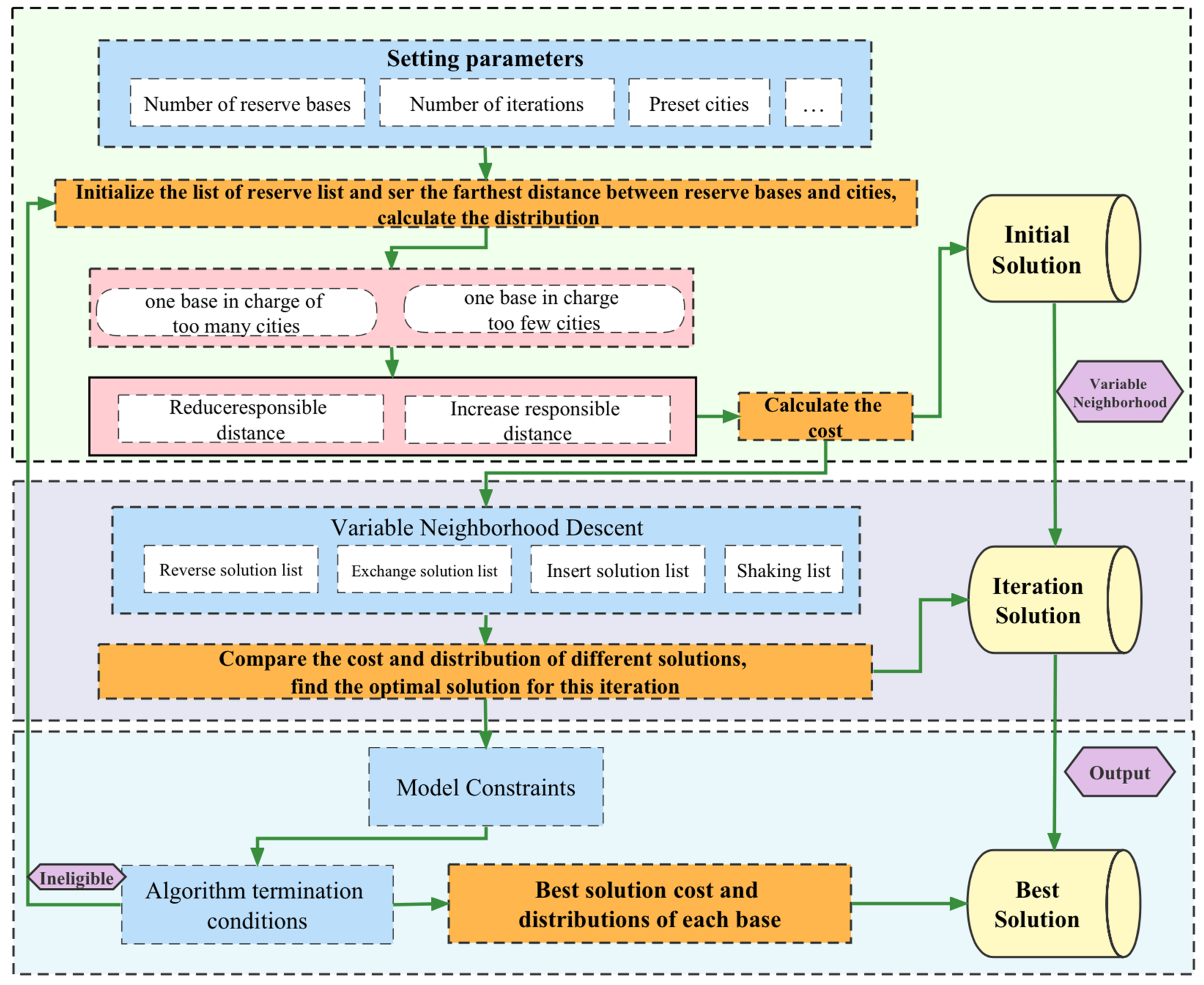
3.6. Algorithm Design

This paper uses the VNS algorithm, the specific algorithm flow and solving model. Solving ideas are shown in Figure 2 and Figure 3.

4. Model Data

The following data should be collected to solve the above objective function model: (1) the set of facilities and points of the candidate emergency rescue material reserve base V = {vj|j = 1, 2, …, n}; (2) the urban set of emergency relief demand points U = {ui|I = 1, 2, …, m}; (3) ui (I = 1, 2, …, m) is the distance d (ui, vj) from the facility point vj (vj ∈ V) of the alternative emergency material reserve base; and (4) the limit distance D from the facility point to the disaster site.

4.1. Collection of Alternative Emergency Material Reserve Base Locations

In this paper, considering the high safety insurance coefficient of railway transportation for any state in a large country at present, the most qualified cities are usually the cities of the states. At the same time, the number of national emergency supply reserve bases should not be too large. Therefore, it is appropriate to consider the cities of the states as alternative national emergency material reserve bases. Therefore, the number of alternative reserve bases at the national level is 28 state cities.

4.2. Emergency Supplies Need to Be Gathered in the Affected Cities

According to the national level, state level, city and county level reserve level emergency prevention and rescue, when a catastrophic disaster occurs, the disaster relief materials at the preassigned facilities of the national material reserve base are first transported to the affected state and then sent to the affected cities and cites of the state by railway, state road or county road, for emergency response [5]. In order to facilitate the analysis, the model takes the city of a state as the city of emergency supplies demand in the disaster area. Thus, 28 cities with emergency needs were identified. In this paper, the cities of the 28 states (numbered 1–28) are studied in two roles, that is, the alternative cities of the emergency material reserve base facilities (numbered J1–J28) and the cities of emergency demand (numbered I1–I28).

4.3. Transportation Distance from the Demand Place to the Alternative Reserve Base

Considering that the country’s railway transport safety insurance coefficient is higher than other traffic roads, the transportation of emergency rescue materials mainly adopts railway transportation. Therefore, the distance data from the emergency demand area to the candidate national reserve facility area in this paper uniformly adopt the shortest transportation distance of railway trains in this country current urban areas. The shortest traffic distance data are from the country’s Railway Information Platform.

4.4. Space Limit Distance

The facilities of the national emergency materials reserve base mainly deal with major emergencies. Generally, in the event of a sudden catastrophic disaster, the demand for emergency supplies increases greatly in a short time due to the need for relief and disaster reduction, and state and municipal emergency supplies can only meet the demand for emergency supplies for a short time. This will leave a certain buffer time for the allocation and transportation of the near national emergency reserve relief materials. The maximum distribution time can be inferred and determined according to the support time of the emergency relief materials that may be supplied by the county, the city in the demand area and the maximum time of the essential materials (“water” resources) that are most needed by human beings in the process of suffering from the disaster. Considering that, the facilities of the national emergency reserve base will be distributed to the disaster stricken states in the first stage after the occurrence of major and serious risk events, and the distribution time will not exceed 1 day. The second stage is to deliver the goods to the cities in the disaster-affected areas within the state, which are mostly transported by rail or road, with a conservative time of no more than 1 day. The third stage is to use more road distribution from the city and county to the victims of the disaster. Considering the road traffic conditions at the grass-roots level, the conservative time should not exceed 1 day. Therefore, it is reasonable to assume that the maximum distribution time of relief materials from the national reserve base to the victims of the disaster should not exceed 3 days [5].
It can be seen that the distribution from national-level emergency materials and facilities to the state (without a national-level emergency reserve point) should be completed within 1 day. Considering the loading, transshipment, unloading at destination, and transportation time between the reserve point and the station, it can be assumed that the maximum transit time of emergency supplies is 12 h (in practice, it can be relaxed to 12–15 h according to the rescue situation of the disaster area and the state). Based on the current normal running speed of freight trains in this country of 100 km/h, the coverage radius of the reserve base can be calculated as D = 1200 km.

5. Results

5.1. Solve the Model

The VNS algorithm is selected, and programmed using Python 3.7.4 (Python Software Foundation: Wilmington, DE, USA) run on a 2.3 GHz 4–core computer. VNS calculated the number of facility points of 5–10. Table 4 lists various values of P (P = 5, 6 …, 10) and sets the maximum distance. This problem can be solved in the following two cases.
Case 1: The optimal location is not restricted by the administrative system; that is, the optimization is only based on the number of reserve points d and the maximum distance of the national emergency material reserve base, which is no administrative restrictions on site selection. In this case, the alternative reserve base is not affected by subjective selection and is completely calculated according to the model and algorithm. Case 2: Restricted by the administrative system, which is administrative restrictions on site selection. That is, considering the administrative management system of the central government of this country, no matter how many national emergency supply reserve bases are set up, a national reserve base is always set up in the capital.
Case 1: Under the condition of no administrative restrictions on site selection, the results obtained by running the program are shown in Table 4. The serial number in the feasible solution is the city number in Table 3. From the running results, the VNS algorithm has a high calculation accuracy in this problem, the solution is in line with the actual situation.
Case 2: Under the limited location of a national reserve base in the capital of this country, the VNS algorithm is selected for re-simulation to obtain the optimal feasible solution, as shown in Table 5.

5.2. Result Analysis

According to the experimental results in Table 4, Table 5 and Table 6. The city coverage sequence in the Table 6 is the state city number sequence. The following conclusions can be drawn:
(1) The number of national emergency reserve bases is highly negatively correlated with the transportation speed of emergency materials. Since the maximum distance set is equal to the multiplication of the maximum time limit for emergency material transportation and the speed per hour of freight train operation, when the former is unchanged, the faster the speed per hour of freight train operation, the greater the maximum distance set, and the smaller the number of national emergency reserve base points set accordingly. It means if the maximum distance set is larger, the number of national emergency reserve base points will be smaller, otherwise, it will be unchanged.
(2) The administrative unrestricted location scheme of the national emergency reserve base is superior to the restricted location scheme.
The algorithm shows that, in case 1, 35.72% of the 28 emergency demand city of state are covered by one national reserve base, 64.28% are covered by 2–5 reserve bases, and each demand city of the state is covered or governed by the response services of 2.29 national reserve bases, with a standard deviation coefficient of 0.51.
In case 2, it is necessary to ensure that a national reserve base is set up in the capital of this country. In this case, 39.29% of the 28 cities in need are covered by one national reserve base and 60.71% are covered by more than 2–4 national reserve bases. On average, each demand city of the state is covered by 2.11 national reserve bases. The standard deviation coefficient is 0.53. Compared with case 1, the response coverage of each demand city under the limited situation decreases by 0.18, on average, 7.86%, and the dispersion of response coverage becomes larger. It can be seen that the situation of the no administrative restrictions on site selection is better than that of the restricted site selection, which indicates that administrative restricted site selection is a sub-optimal solution when the number of national emergency reserve bases remains unchanged, as shown in Table 6.
(3) The experimental results show that the number of emergency reserve base points at the national level should be set at eight. Based on the high safety factor of railway transportation and the current speed of freight train in this country is 100 km/h, we set the large distance as 1200 km. The algorithm shows that the number of emergency reserve base points at the national level should be eight. That is, the optimal plan is to establish emergency reserve bases at the national level in the cities of I4, I5, I8, I12, I20, I22, I24 and I26. The maximum limit distance is 1187 km and the rescue time is 11.87 h, which only accounts for 16.5% of the golden rescue time. The second-best solution is I1, I8, I13, I19, I21, I23, I24, I27 and other cities.
Table 6. Number of emergency demand cities covered.
PCase 1: 28 Demand Cities Are, Respectively Covered by National Reserve BasesCase 2: 28 Demand Cities Are, Respectively Covered by National Reserve Bases
5[3,3,3,2,2,1,1,1,1,1,1,2,2,2,2,2,3,2,2,2,3,4,2,1,2,1,1,1][4,4,4,2,2,2,2,2,3,3,3,3,1,3,3,3,4,3,1,1,2,2,2,1,4,2,2,2]
6[2,2,2,2,1,1,1,1,1,1,1,2,2,3,2,2,3,3,3,3,5,2,4,2,2,1,1,1][2,2,1,2,1,2,2,2,1,1,1,2,1,2,1,1,4,3,2,3,4,2,4,3,2,1,1,2]
7[4,4,4,4,2,2,1,1,1,2,1,3,2,2,3,3,4,3,2,3,4,3,3,2,4,3,2,2][4,4,3,4,1,2,2,2,4,4,4,4,3,3,3,3,4,3,1,1,3,2,1,1,4,1,1,2]
8[3,3,3,4,3,1,1,1,1,1,1,2,1,1,2,3,1,2,1,2,4,3,3,3,5,4,2,3][1,1,1,1,1,2,2,1,1,2,1,2,2,2,1,1,3,4,3,4,4,4,4,3,3,2,2,1]
9[2,2,2,3,1,2,1,1,2,3,2,3,2,2,2,4,2,3,3,3,4,3,4,2,3,3,1,2][1,1,1,1,1,2,2,1,2,3,2,3,3,3,1,2,4,4,2,2,3,1,4,2,3,3,2,1]
10[3,3,2,2,1,2,1,1,3,3,2,3,2,3,3,3,2,4,3,3,2,2,4,2,2,2,1,1][3,3,2,2,1,2,1,1,3,3,2,3,2,3,3,3,2,4,3,3,2,2,4,2,2,2,1,1]
Note: The city coverage sequence in the table is the state city number sequence.

6. Conclusions

(1) The site selection and layout of national emergency supply reserve facilities should follow the principle of high-quality rescue and disaster reduction. If the actual quantity of a national emergency supply reserves base location does not conform to the objective reality needs, it may appear the reserve point is not enabled in the disability state for a long time, therefore, more reserves come out of save points at the same time as disaster relief supplies; supply disaster relief supply then exceeds demand, and reduces the disaster reduction and relief operation management to the quality and performance. In addition, it will also affect the location and layout of provincial emergency material reserve base facilities, as well as the location and quantity of the material reserve inventory of various regions and cities and counties in each state. In a certain period of time, under the premise that the overall national emergency rescue material reserve is certain, the material reserve of a single emergency reserve base will not reach the standard reserve, thus affecting part of the disaster stricken areas that cannot be covered by the materials and services provided by the nearest emergency rescue facilities.
(2) The mathematical model and related algorithm experiments show that the maximum optimistic railway transportation distance from the facility point to the disaster stricken point is assumed to be 1200 km. Therefore, the calculated results according to the algorithm in this paper are as follows. In the countries studied, the optimal plan is to establish national emergency reserve base in eight state cities, including I4, I5, I8, I12, I20, I22, I24 and I26, which have established emergency reserve bases at the national level The maximum limit distance is 1187 km, and the rescue time is 11.87 h, which only accounts for 16.5% of the golden rescue time. Each city of the required state is provided with response services by at least one national reserve base, and more than 60% of the states can be covered by the response and rescue support of two to four national emergency material reserve bases. The calculation results of the location of the national emergency reserve base without administrative restrictions are better than those of the restricted location. Therefore, the location model and related research in this paper have significant effects on the location and optimal layout of national and state emergency material reserve facilities.
(3) Future work should focus on the following issues: how to optimize the layout of emergency material reserve base facilities at the local and state levels, after optimizing the layout of emergency material reserve base facilities at the national level. In the site selection and construction practice of specific base facilities, all kinds of practical factors should be comprehensively considered. The focus of future research is to improve the practicability of site selection.

Author Contributions

Conceptualization, Z.W. and C.L.; methodology, C.L. and Y.Z.; software, Y.Z. and Z.Y.; validation, C.L.; formal analysis, C.L.; investigation, Z.Y. and Y.Z.; resources, Z.W. and Z.Y.; data curation, C.L.; writing—original draft preparation, C.L. and Y.Z.; writing—review and editing, Z.W. and Z.Y.; supervision, Z.W. and C.L.; project administration, C.L., Z.Y. and Y.Z.; funding acquisition, Z.W. All authors have read and agreed to the published version of the manuscript.

Funding

This work was supported by the Project supported by Innovation Fund of Industry, Education and Research of China University (2021LDA11003) and Teaching Reform Project of Capital University of Economics and Business in 2022.

Institutional Review Board Statement

Not applicable.

Informed Consent Statement

Not applicable.

Data Availability Statement

All the data has been included in the manuscript.

Conflicts of Interest

The authors declare no conflict of interest.

References

  1. Cao, C. Study on Sustainable Development Oriented Emergency Resource Allocation Decisions in Large-scale Natural Disasters. Ph.D. Thesis, Tianjin University, Tianjin, China, 2018. [Google Scholar]
  2. UNDRR. Human Cost of Disasters: An Overview of the Last 20 Years (2000–2019) [R/OL]; UNDRR: Geneva, Switzerland, 2020. [Google Scholar]
  3. Cao, C.; Li, C.; Yang, Q. Multi-objective optimization model of emergency organization allocation for sustainable disaster supply chain. Sustainability 2017, 9, 2103. [Google Scholar] [CrossRef] [Green Version]
  4. UNDRR. Global Assessment Report on Disaster Risk Reduction 2022: Our World at Risk: Transforming Governance for a Resilient Future; GAR2022. CH1211 Geneva 2; UNDRR: Geneva, Switzerland, 2022. [Google Scholar]
  5. Xi, M.; Zhang, J.; Zhao, Q.; Ye, F. The research of location problem of national emergency reserve facilities for emergency relief based on P-center problem. J. Nat. Disasters 2019, 28, 123–129. [Google Scholar] [CrossRef]
  6. Zhou, X.; Zhang, Y.; Zhu, Z.; Yang, Z. Comparative Study and lessons learned from foreign emergency management system. Water Power 2021, 47, 112–117+131. [Google Scholar]
  7. Chen, D. Resources Allocation and Optimization in Mass Disaster: The Case of Earthquake. Ph.D. Thesis, Beijing Institute of Technology, Beijing, China, 2017; pp. 9–10. [Google Scholar]
  8. Kariv, O.; Hakimi, S.L. An algorithmic approach to network location problems I: The P-centers. SIAM J. Appl. Math. 1979, 37, 513–538. [Google Scholar] [CrossRef]
  9. Mladenovic, N.; Labbe, M.; Hansen, P. Solving the p-center problem with tabu search and variable neighborhood search. Networks 2003, 42, 48–64. [Google Scholar] [CrossRef] [Green Version]
  10. Pullan, W. A memetic genetic algorithm for the vertex p-center problem. Evol. Comput. 2008, 16, 417–436. [Google Scholar] [CrossRef] [Green Version]
  11. Liu, Y.C. Two lower-bounding algorithms for the p-center problem in an area. Comput. Urban Sci. 2022, 2, 5. [Google Scholar] [CrossRef]
  12. Pérez-Mesa, J.C.; Serrano-Arcos, M.M.; Jiménez-Guerrero, J.F.; Sánchez-Fernández, R. Addressing the Location Problem of a Perishables Redistribution Center in the Middle of Europe. Foods 2021, 10, 1091. [Google Scholar] [CrossRef]
  13. Bian, D. Research on the Algorithms for Solving the p-Center Problems in the Plane. Master’s Thesis, Dalian Maritime University, Dalian, China, 2019. [Google Scholar] [CrossRef]
  14. Rawls, C.G.; Turnquist, M.A. Pre-positioning and dynamic delivery planning for short-term response following a natural disaster. Socio-Econ. Plan. Sci. 2012, 46, 46–54. [Google Scholar] [CrossRef]
  15. Li, A.C.Y.; Nozick, L.; Xu, N. Shelter location and transportation planning under hurricane conditions. Transp. Res. Part E Logist. Transp. Rev. 2012, 48, 715–729. [Google Scholar] [CrossRef]
  16. Barzinpour, F.; Esmaei Ii, V. A multi-objective relief chain location distribution model for urban disaster management. Int. J. Adv. Manuf. Technol. 2014, 70, 1291–1302. [Google Scholar] [CrossRef]
  17. Tuzkaya, U.R.; Yilmazer, K.B.; Tuzkaya, G. An integrated methodology for the emergency logistics centers location selection problem and its application for the Turkey case. J. Homel. Secur. Emerg. Manag. 2015, 12, 121–144. [Google Scholar] [CrossRef]
  18. Toregas, C.; Swain, R.; Revelle, C. The location of emergency service facilities. Oper. Res. 1971, 19, 1363–1373. [Google Scholar] [CrossRef]
  19. Trevor Hale, R. Christopher. Improving supply chain disaster pre-paredness: A decision process for secure site location. Int. J. Phys. Distrib. Logist. Manag. 2005, 35, 195–207. [Google Scholar] [CrossRef] [Green Version]
  20. Pacheco, J.A.; Casado, S. Solving two location models with few facilities by using a hybrid heuristic: A real health resources case. Comput. Oper. Res. 2005, 32, 3075–3091. [Google Scholar] [CrossRef]
  21. Davidović, T.; Ramljak, D.; Šelmić, M.; Teodorović, D. Bee colony optimization for the P-center problem. Comput. Oper. Res. 2011, 38, 1367–1376. [Google Scholar] [CrossRef]
  22. Lu, X.L.; Hou, Y.X. Allocation of chinese national emergency material depository based on facility location theory. Econ. Geogr. 2010, 30, 1091–1095. [Google Scholar] [CrossRef]
  23. Zhang, M.; Huang, J. Evaluation of National Storehouse Location with Failure Scenarios of Key Traffic Road. Oper. Res. Manag. Sci. 2018, 27, 11–16. [Google Scholar] [CrossRef]
  24. Cong, W.; Yu, W. Model and Algorithm for Location of Regional Emergency Material Reserve Site in Typhoon Scenarios. Ind. Eng. Manag. 2020, 25, 68–74. [Google Scholar] [CrossRef]
  25. Feng, J.; Gai, W. Research on multi-objective optimization model and algorithm for reserve site selection of emergency materials. J. Saf. Sci. Technol. 2018, 14, 64–69. [Google Scholar]
  26. Chen, Y.; Zhao, Q. The model and algorithm for emergency supplies distribution based on fairness. Syst. Eng.-Theory Pract. 2015, 35, 3065–3073. [Google Scholar]
  27. Yan, X.; Hou, H.; Yang, J.; Fang, J. Site Selection and Layout of Material Reserve Based on Emergency Demand Graduation under Large-Scale Earthquake. Sustainability 2021, 13, 1236. [Google Scholar] [CrossRef]
  28. Ma, X.; Su, H.; Sui, L. The Cooperative Game Research of Emergency Material Reserve in Beijing City. Open J. Soc. Sci. 2016, 4, 40–45. [Google Scholar] [CrossRef] [Green Version]
  29. Matsutomi, T.; Ishii, H. An emergency service facility location problem with fuzzy objective constraint. Fuzzy Syst. 1992, 12, 315–322. [Google Scholar]
  30. Zhang, L.; Lu, J. Location of maritime emergency supplies repertories considering risk uncertainty. Chin. Saf. Sci. J. 2019, 29, 173–180. [Google Scholar] [CrossRef]
  31. Li, Z.; Ma, Z. Coordinate location model for regional hierarchical reserve depots of emergency materials. J. Nat. Disasters 2012, 23, 13–17. [Google Scholar]
  32. Xi, Y.; Wei, L. Research on Location Selection of Emergency Material Storage Based on AHP Model—A Case Study of Nanjing City. Logist. Eng. Manag. 2021. [Google Scholar] [CrossRef]
Figure 1. Flow chart of national emergency material reserve base site selection.
Sustainability 14 15922 g001
Figure 2. Flowchart of VNS algorithm.
Sustainability 14 15922 g002
Figure 3. Solution model diagram.
Sustainability 14 15922 g003
Table 1. Factors influencing the location of national emergency material reserve facilities.
NumberInfluencing FactorsAnalysis of Factors
1Rescue target rangeCovering the vast mainland of a country, emergency rescue follows the principle of “regional management and nearby response”.
2Disaster response AreaFor the very low probability and the state level cannot meet the needs of the rescue of major emergency disaster. Materials start the latest, the lowest probability of use.
3Ease of transportationThe surrounding traffic roads are connected with the surrounding areas and the outside world with a large number of access routes, good access quality, large number of trunk routes and strong road traffic capacity
4Hydro-geographical conditionsRelief supplies usually need to be stored for a long time in a clean, dry, open area with good air circulation.
5Rescue transport distancePrimary influencing factor. There is an inverse relationship between the number of national emergency material reserve base and the maximum rescue transport distance.
6Rescue transport modeThere is an inherent relationship between the mode of transport and the distance of transport.
Air transport: time crunch, small amount of supplies;
Railway transportation: good safety, fast speed, large volume;
Road transportation: short distance transportation, flexible, moderate volume.
7Regional equilibriumPay attention to economically developed areas and areas with frequent geological disasters.
8Scope of material reserveMainly affected by the shelf life, we can cooperate with local reserves to meet the needs of emergency supplies in disaster areas in the early stage of disaster emergencies.
9Build a reasonable quantityThe proportion between the number of national emergency material reserve bases and the number of state base facilities should be reasonable.
Table 2. Factors influencing site selection of emergency material reserve base facilities at state level.
NumberInfluencing FactorsAnalysis of Factors
1The number of people in needIn the case of a certain hazard level and a large number of people in the rescue area, reserve bases should be arranged nearby to reduce transportation costs and adverse traffic conditions and meet the needs of more emergency supplies in the disaster area.
2Rescue needs to be the level of economic developmentThe dependence on external emergency rescue is low, the capacity of the reserve base is correspondingly small, and the reserve is relatively small. The dependence on external emergency rescue is high, and the reserve base has a large capacity and relatively large reserve.
3Rescue needs the safety of local peopleThe safety quality of the public is high, the self-reserve material is sufficient, the dependence on external demand is not high, the base reserve can be relatively small.
4Frequency and severity of regional disastersAccording to the historical frequency and level of disasters, the quantity and type of materials are determined, and the site selection and configuration of reserve points are affected.
Table 3. Number of reserve bases.
State NumberNumber of Reserve BasesState NumberNumber of Reserve BasesState NumberNumber of Reserve BasesState NumberNumber of Reserve Bases
J13J82J152J222
J23J92J162J232
J32J102J172J242
J42J112J182J251
J52J122J192J261
J62J132J202J271
J72J142J212J281
Table 4. Reserve point without administrative restrictions.
PMaximum Distance/kmExact Optimal Solution/kmRelative Error/%Time/sFeasible Solution
51560 (130 × 12)15311.863550.36[7,12,19,24,28]
61440 (120 × 12)14380.145545.20[7,12,19,20,24,27]
71320 (110 × 12)12932.053751.81[4,5,6,12,19,21,24]
81200 (100 × 12)11871.083554.18[4,5,8,12,20,22,24,26]
91080 (90 × 12)9759.723143.91[4,8,14,15,18,22,23,24,26]
10960 (80 × 12)9402.085201.78[1,6,10,14,15,19,20,22,24,26]
Note: The serial number in the feasible solution is the city number in Table 3, the same as in the following table. The maximum distance set in the table is the freight train speed times the transit time of 12 h.
Table 5. Reserve points with administrative restrictions.
PMaximum Distance/kmExact Optimal Solution/kmRelative Error/%Time/sFeasible Solution
51560 (130 × 12)15093.273163.32[1,8,11,23,25]
61440 (120 × 12)14241.115851.78[1,8,19,20,22,24]
71320 (110 × 12)13180.153483.95[1,8,10,12,13,24,27]
81200 (100 × 12)11395.084130.70[1,8,13,19,21,23,24,27]
91080 (90 × 12)10691.023449.69[1,8,1,13,19,21,22,24,27]
10960 (80 × 12)9402.085846.16[1,6,10,14,15,19,20,22,24,26]
Publisher’s Note: MDPI stays neutral with regard to jurisdictional claims in published maps and institutional affiliations.

