
Article

Black Rails in Baja California
by
Hiram Rafael Moreno-Higareda
1,2,
Courtney J. Conway
3,
Héctor Manuel Sánchez-Márquez
4,
Osvel Hinojosa
5,
Enrique Zamora
6,
Hans Sin
7,
Gorgonio Ruiz-Campos
2,
Justyn T. Stahl
8,
Eduardo Palacios
9 and
Horacio de la Cueva
1,*
1
Departamento de Biología de la Conservación, Centro de Investigación Científica y de Educación Superior de Ensenada (CICESE), Carretera Ensenada-Tijuana No. 3918, Pedregal Playitas, Ensenada 22760, BC, Mexico
2
Facultad de Ciencias, Universidad Autónoma de Baja California, Carretera Transpeninsular Ensenada-Tijuana No. 3917, Colonia Playitas, Ensenada 22860, BC, Mexico
3
U.S. Geological Survey—Idaho Cooperative Fish and Wildlife Research Unit, University of Idaho, 875 Perimeter Dr. MS 1141, Moscow, ID 83844-1141, USA
4
Siempreviva, Calle Tercera 1282, Zona Centro, Ensenada 22800, BC, Mexico
5
Coastal Solutions Fellows Program, 159 Sapsucker Woods Rd, Ithaca, NY 14850, USA
6
Independent Researcher, B. Botaris 286, Punta Banda III, Ensenada 22897, BC, Mexico
7
California Department of Fish and Wildlife, 3883 Ruffin Road, San Diego, CA 92123, USA
8
San Diego Bay National Wildlife Refuge, United States Fish and Wildlife Service (USFWS), 1080 Gunpowder Point Dr., Chula Vista, CA 91910, USA
9
Centro de Investigación Científica y de Educación Superior de Ensenada, Baja California Unidad La Paz (CICESE ULP), Miraflores No. 334 e/Mulegé y La Paz, La Paz 23050, BCS, Mexico
*
Author to whom correspondence should be addressed.
Birds 2026, 7(3), 51; https://doi.org/10.3390/birds7030051
Submission received: 27 June 2026 / Revised: 16 August 2026 / Accepted: 17 August 2026 / Published: 21 August 2026

Simple Summary

The California black rail (Laterallus jamaicensis coturniculus) is the western subspecies of the smallest North American rail. It is non-migratory, cryptic, poorly known, and federally endangered. We compiled historical records from the last 120 years (1905–2025) of its presence in Baja California and report data from surveys conducted from 2000–2025 in western Baja California and the Colorado River Delta wetlands, where suitable habitats exist. The number of records has increased with more biologists in the field, eBird, and the North American Marsh Bird Protocol. The 35 historical records in Baja California include a minimum reported count of 56 California black rails. In the Colorado River Delta, 22 years of surveys reported 20 detections across nine survey events. In 2023, surveys in suitable rail habitat yielded the first records of this bird in Estero de Punta Banda with a maximum monthly count of 15 detections, and 31 at Bahía de San Quintín, both in western Baja California. The scant records of the California black rail in northwestern México’s wetlands suggest that the bird is rare and any efforts to increase numbers will likely require explicit conservation measures that expand and improve its habitat.

Abstract

Summarizing records from 1905 to 2025, we document the presence and distribution of the California black rail (Laterallus jamaicensis coturniculus) in northwestern México, particularly Baja California and the Colorado River Delta. This subspecies has a restricted distribution in the western U.S. and northwestern México. We found few records over the past century: sparse detections in the early 1900s and an increase in reported records after 2000. Over 120 years, we compiled 35 documented records of California black rail occurrence in Baja California with a minimum reported count of 56 rails. Our call-broadcast survey methods reconfirmed previously occupied sites and documented the species at a previously unreported site. Surveys in the Baja California portion of the Colorado River Delta yielded 20 detections across nine survey events between 2000 and 2022. In April 2003, standardized surveys detected 12 California black rails: 7 in Bahía de San Quintín, 3 in Arroyo San Telmo, and 2 in Arroyo El Rosario. Our recent survey work (2022–2025) recorded maximum monthly counts of 31 detections at Bahía de San Quintín and 15 detections at Estero de Punta Banda, the latter representing a previously undocumented location for the subspecies. These surveys also yielded the first photographic and acoustic documentation of California black rail in México. The contribution of spatial and temporal data provided by citizen science platforms increased our understanding of the subspecies’ distribution. Enforceable protection of this subspecies’ habitat is needed to safeguard its persistence.

1. Introduction

The black rail (Laterallus jamaicensis) is the smallest North American rail. Five subspecies are recognized; the two occurring in North America are the eastern black rail (L. j. jamaicensis) and the California black rail (L. j. coturniculus). The eastern subspecies is listed as federally threatened in the U.S. [1] and has both migratory and resident populations occurring along the Atlantic and Gulf Coasts of the U.S. and the Caribbean, with inland populations in Kansas and Colorado [2]. The eastern black rail prefers marshes with infrequent tidal inundation [2,3]. California black rails are state-listed as threatened in California [4,5], and federally endangered in México under NOM-059-SEMARNAT-2010 [6,7]. Both subspecies share conservation problems, including habitat loss caused by human development and climate variation [2,3].
Compared to the eastern black rail, the California black rail is smaller, has a brighter plumage, is non-migratory, and tolerates greater flooding in tidal marshes, provided surrounding upland vegetation is available for escape during extreme high tides [8,9].
The California black rail inhabits both tidal and freshwater wetlands, preferring shallow-water wetlands (0–5 cm) and stable water levels, with short emergent vegetation [2,10,11]. These habitat features are associated with tidal elevation and are influenced by freshwater presence at our Baja California study sites [12,13]. The California black rail has declined throughout its range, existing today in a series of non-contiguous populations within remnant tidal marshes on the western coasts and inland sites of the U.S. and México [2,9,14]. The California black rail is arguably rarer than its eastern counterpart [15]. We know relatively little about the bird’s distribution and remaining core habitat in northwestern México, where likely threats include the lack of enforcement of land-use and water-use regulations.
Confirmed records of the California black rail in México are restricted to wetlands in Sonora and Baja California; one unverified record has also been reported from Sinaloa [16,17,18,19,20,21]. A small Sonoran population occurs in the Ciénega de Santa Clara and El Doctor wetlands [11,19]. Two individuals were detected in 2001 at the Río Hardy and Laguna del Indio, and seven rails were detected in 2010 along the Colorado River [19,20]. Despite these records, systematic surveys have been limited, and the species’ current distribution remains poorly documented in North America, especially in northwestern México. Documenting the status and distribution of this bird in Baja California, near the southern limit of the species’ distribution, will help determine the most effective conservation measures for protecting this rare species.
Historical records of California black rail in the Bahía de San Quintín area were compiled by [18], and [21] recorded one individual at San Telmo and another at El Rosario, Baja California. Additional observations were reported by [15,22]. Given the rarity of this bird and the lack of information on its status and distribution in Baja California, we: (1) compiled and summarized all records for the California black rail in Baja California, and (2) conducted standardized call-broadcast surveys in potentially suitable wetlands to characterize occurrence patterns, detection frequencies, and detectability to better document current status and distribution in northwestern Baja California, México. We focused surveys within three wetland regions in northwestern México (Figure 1): the Baja California portion of the Colorado River Delta (Humedales del Río Colorado), Estero de Punta Banda, and Bahía de San Quintín.

2. Materials and Methods

2.1. Historical Records

To compile and summarize records of California black rail in Baja California, we conducted a comprehensive literature review spanning both published and unpublished sources. Our review included early 20th-century ornithological reports and historical field notes, as well as more recent studies from the Museum of Vertebrate Zoology, USGS Alaska Science Center, and North American Birds. Key references [16,17,18,23] provided context and validated our findings. We accessed museum and archival records, including specimen data from expeditions led by [24,25,26], and cross-validated these records against published catalogues and monographs. We expanded our dataset by incorporating contemporary observations from the citizen science platform eBird [15], filtering records based on observer, geographic accuracy, and data reliability. All records were summarized by locality, year, source type, and detection method to describe the historical distribution of the species in Baja California. A record is data obtained from museums, literature, unpublished sources, or citizen science. A detection occurs when a rail is seen or heard during a formal survey. Repeated sightings do not equate to distinct individuals, and non-quantitative data only confirm that the species was present, without indicating its number.

2.2. Study Areas

The Colorado River Delta is Ramsar site No. 814 [27], located on the western coast of Sonora and the northeast coast of Baja California, México (250,000 ha, 31°49′ N 114°58′ W). The site is integrated into the Pacific Coast Shorebird Conservation Strategy (Site No. 87) and endorsed by the Western Hemisphere Shorebird Reserve Network [28]. This area includes most of the habitat for the Yuma Ridgway’s rail (Rallus obsoletus yumanensis) [11,20,29,30], featuring riparian zones maintained by flooding, lagoons, and mudflats influenced by the Gulf of California tides, and marshes fed by run-off and springs. Dominant vegetation includes southern cattail (Typha domingensis), Palmer’s saltgrass (Distichlis palmeri), the native Fremont cottonwood (Populus fremontii)—Goodding’s willow (Salix gooddingii) association, and introduced salt cedar (Tamarix ramosissima).
Estero de Punta Banda (EPB) is in the municipality of Ensenada, Baja California, México (2393 ha, 31°44′ N, 116°37′ W; Figure 1) and is Ramsar site No. 1604 [31], but it lacks federal, state, or municipal government conservation protection. EPB includes tidal channels, mudflats, and pools that bisect the tidal marsh vegetation. These marshes cover 326 ha [31] and receive freshwater from winter rains (200 to 400 mm annually [12,13]). Rainfall drains into two hydrological basins, the San Carlos and Las Ánimas Streams, supporting seasonal riparian vegetation and rail habitat [32]. EPB is undergoing development pressures through urbanization and agriculture in adjacent upland areas that could threaten its persistence and biological integrity [31]. The Antonio Perisky Private Reserve protects over 70 ha.
Bahía de San Quintín (BSQ) is 200 km south of Estero de Punta Banda in the Municipality of San Quintín, Baja California, México (24,622 ha; 30°25′34″ N, 115°59′4″ W; Figure 1B), and is Ramsar site No. 1775 [33]. The area is used for oyster farming [34,35,36], and the coastal lagoon is divided into two subunits: Bahía de San Quintín and Bahía Falsa. The lagoon has mudflats exposed during low tides, 805 ha of salt marsh vegetation, and tide-driven seawater input. The lagoon is protected to the west and south by sandbars and receives freshwater via winter rain (200 to 500 mm annually [37]). The state of Baja California manages a 201-ha upland reserve in BSQ. Two private conservation areas established by Terra Peninsular and a private landowner protect the marsh from development.
The dominant plants at EPB and BSQ are pickleweed (Salicornia pacifica and S. bigelovii) and California cordgrass (Spartina foliosa) [38]. The higher areas within the coastal lagoon are characterized by Parish’s glasswort (Arthrocnemum subterminale).

2.3. Surveys

Survey sites were randomly selected within suitable habitat for general marsh bird surveys and California black rail surveys at BSQ and EPB; sites were selected based on confirmed presence or potentially suitable habitat.
Hinojosa et al. [19] performed comprehensive surveys in the Baja California portion of the Colorado River Delta, between 2000 and 2022, to ascertain the presence of the California black rail and other marsh birds. The surveys were conducted during the species’ presumed breeding season, using methods based on [39], and incorporating regional methodologies [19]. At each survey station, observers recorded all waterbird species detected within a 200 m radius. Pre-recorded vocalizations for the target species were played sequentially. To capture peak vocal activity, surveys were performed during optimal time windows, starting at sunrise and continuing until no later than 10:30 a.m. Transects and mini-route locations were selected non-randomly to maximize coverage of the various zones and wetland environments across the delta. The route’s design was determined by habitat suitability, focusing on areas with marsh vegetation, salt cedar, native riparian plants, and surface water. Fifteen transects comprising 305 survey points were established across multiple areas in the Baja California portion of the Colorado River Delta: Río Hardy, Laguna del Indio, Andrade Mesa Wetlands, Colorado River, and Las Arenitas wetland. The survey points were separated by a minimum distance of 200 m to ensure independent waterbird detections (black rail calls are seldom audible beyond 150 m [39,40,41,42]). Transects were strategically located along the ecotones between marsh and upland or between marsh and open water.
We conducted standardized surveys in April 2003 following [39], using randomized survey points in BSQ and the lower parts of Arroyo San Telmo and Arroyo El Rosario, near the coast, to detect California black rails. Arroyos San Telmo and El Rosario originate in the Sierra de San Pedro Mártir and are riparian wetlands with historical black rail records, especially Arroyo San Telmo [25].
In 2022, we conducted call-broadcast surveys for the California black rail at EPB and BSQ during their presumed breeding season, March to August. A survey was defined as a single visit to a set of sampling points grouped together in survey routes within a site, and methods followed the standardized North American Marsh Bird survey protocols of [39,40]. In 2022, we used a multi-species call-broadcast sequence that included calls for California black rail, Virginia rail (Rallus limicola), and light-footed Ridgway’s rail (Rallus obsoletus levipes). We conducted surveys during both morning (0.5 h before sunrise to 1 h after sunrise) and evening (1 h before sunset to 0.5 h after sunset) survey windows, as per [40]. Our surveys included 24 survey routes with 112 survey points, with ≥200 m between points and 300 m between routes. During May, June, and July 2023–2025, we conducted additional surveys at EPB and BSQ in areas where we had detected California black rail on the initial surveys, or where we found the suitable habitat described by [2,10]. For security reasons, all surveys conducted during 2023–2025 were restricted to the morning survey window. Based on suitable habitat continuity at each location, we established a combination of survey routes and points along each route, as described in [41,42]. We established one survey route with three survey points at EPB and one survey route with six survey points at BSQ. All survey points were along the vegetated marsh uplands or edges at the upper reaches of the high-tide water line in areas with suitable habitat that might contain California black rail. We do not show maps of our survey routes to protect both fragile habitats and endangered species from unnecessary visits. Surveys were only performed when conditions provided the best conditions for the highest detection probability for rails: no rain and wind speeds ≤ 25 km/h [39,40,41,42,43]. At each survey point, we conducted a 6-min point-count survey consisting of a 3-min passive period followed by a 3-min call-broadcast period. All surveys were conducted during low tides, with a mean air temperature of 17 °C (range: 15–22 °C). During each survey, all California black rails heard or seen were recorded, noting the direction, type of call response, and distance from the surveyor; a Forestry Pro II rangefinder (Nikon, Tokyo, Japan) with an accuracy of 0.3 m was used to estimate the distance to each rail detected. Additionally, we recorded birds that we detected while moving between survey points, but if a bird was suspected of having been previously recorded at an earlier point, only its initial detection was included to avoid duplicate records.
For the 2023–2025 surveys, we used a call-broadcast sequence that only included California black rail calls. A complete survey sequence comprised:
3 min of silence,
45 s of California black rail calls:
  • 3 s of black rail kicky-doo calls
  • 5 s of silence
  • 6 s of black rail kicky-doo calls
  • 5 s of silence
  • 4 s of black rail grrr calls
  • 10 s of silence
  • 12 s of black rail Ink-ink-ink-ink and growl calls
  • 45 s of silence
  • 45 s of California black rail calls (same as above)
  • 45 s of silence
The playback calls were obtained from the recordings of [40,44]; the sound transcriptions were taken from [2,16]. We used an MP3 file to broadcast calls at a volume of 89 dB at 1 m from the speaker [39], using a wireless speaker (VOBCOM IPX7 Waterproof 40 W Bluetooth 5.0 model, Houl Zalee, Meidi Electronics Inc., Shenzhen, China), linked to a mobile phone (Apple iPhone 11, Apple Inc., Cupertino, CA, USA). Vocalizations and video/photo documentation were obtained during surveys in the field using GoPro 10 and GoPro 13 cameras (GoPro, San Mateo, CA, USA). Spectrograms were generated using SoX version 14.4.2 (Sound eXchange; The SoX Team, 2015; https://sourceforge.net/projects/sox/, accessed on 23 June 2026) with the default spectrogram settings (Kaiser window, 512-point FFT). Spectrograms displayed frequencies from 0 to 11 kHz and amplitudes ranging from +3 to −97 dBFS. Temporal scales varied according to the vocalization shown, ranging from 0–7 s to 0–14 s.

2.4. Distance Sampling and Estimates

Descriptive statistical analyses were then performed to quantify temporal and spatial patterns across decades, including the detection frequency and the methods used. Annual detection metrics were summarized by site and year. For each site–year combination, we recorded the total number of detections, the number of survey points, and the number of visits per point. Detections per point were calculated as total detections divided by the number of survey points surveyed, whereas detections per point-visit were calculated as total detections divided by the product of survey points and visits. Detection metrics were treated as indices of detection frequency rather than an estimate of abundance, because repeated detections of a single individual across visits cannot be ruled out. All detection events were tallied through the end of the playback period.
Detection models within Distance software version 8.0 were selected primarily based on biological plausibility, parameter stability, and coefficient of variation while considering Akaike’s information criterion (AIC), with the retained model selected for each site–year combination [2,45].
Detection functions were fitted using conventional distance sampling (CDS) with right truncation at 80 m. Reported parameters include: number of detections (N), model, Akaike’s information criterion (AIC), effective detection radius (EDR), average detection probability within the truncation distance (p), density estimate (D), associated 95% confidence intervals, and coefficient of variation (CV). Parameter constraints were applied to ensure monotonic detection functions due to small N. When candidate models had similar support, biological plausibility, parameter stability, and coefficient of variation were also considered in model selection. Goodness-of-fit was evaluated using the chi-square and Kolmogorov–Smirnov tests provided by Distance Software. Kolmogorov–Smirnov tests were included because analyses were based on exact distances, whereas chi-square results were affected by the distance intervals and pooling applied by the program. Goodness-of-fit statistics are presented in Table S1.

3. Results

3.1. Records

We compiled 35 documented historical records and survey detections between 1905 and 2025 (120 years), with a minimum reported count of 56 California black rails (Table 1 and Table 2). The species was rare throughout this study period in Baja California. Both type of accounts reveal prolonged periods of scarcity followed by an increase in reported detection events after 2000. Bird presence accounts were distributed unevenly through time. Only eight historical records were documented between 1905 and 1999, whereas 27 detection events (77.1% of all compiled accounts) were documented since 2000.
Table 1 shows the California black rail historical records and survey accounts in Baja California. Heard-only detections represented the most common category in recent detection events, whereas specimen historical records predominated in the early twentieth century.
San Telmo and Sangre de Cristo are inland locations with riparian vegetation, while San Ramón is a coastal location. Wilbur [17] reported that no suitable black rail habitat existed at San Telmo, but the species has been detected there repeatedly in recent years [15]. BSQ accounted for most of the historical records.
Additional detections in the Colorado River Delta and the lower Río El Rosario document occurrences at geographically separated localities across the region.

3.2. Field Surveys

Between 2000 and 2022, surveys were conducted at 305 points in the Baja California portion of the Colorado River Delta yielded 20 California black rail survey detections across nine survey events (Table 2). The available surveys yielded the highest numbers of California black rail detections at Andrade Mesa and along the Colorado River.
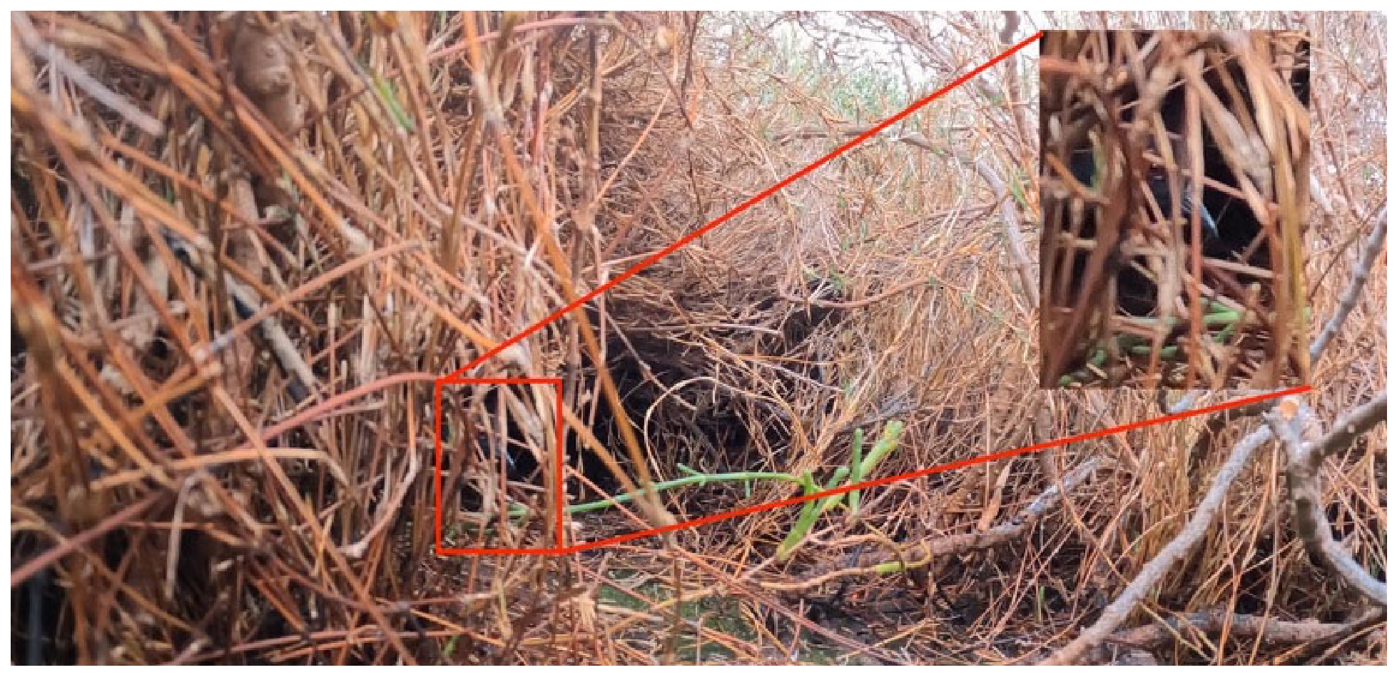
In April 2003, we detected 12 California black rails across three sites: seven birds in BSQ, three in Arroyo San Telmo, and two in Arroyo El Rosario. Surveys conducted in 2022 produced no detections in the morning or evening sampling periods, despite extensive coverage of 24 routes and 112 survey points. In contrast to the 2022 surveys, we detected California black rails at both study sites in 2023; detection records varied by year and site (Table 3). A photograph taken at EPB on 27 May 2023 (Figure 2) is the first photographic record of California black rail in México. Kicky-doo and grrr vocalizations [2,16] from both sites, along with corresponding spectrograms, are included as Supplementary Materials (Audios S1 and S2; Figures S1 and S2) and constitute the first acoustic record of the subspecies in México.
Monthly detection surveys by year are shown in Table 4. EPB showed a marked decline in detection frequency, whereas BSQ had higher and more consistent detection frequencies. Annual detection indices diverged sharply between the two sites (Table 3): detection records at EPB declined by roughly 78% between 2023 and 2025, while BSQ sustained consistent numbers throughout the three years. By 2025, BSQ detections were more than sevenfold those recorded at EPB. These patterns represent differences in detection frequency and should not be interpreted as population trajectories or abundance trends.

3.3. Distance Sampling and Estimates

Sample sizes for distance sampling analyses ranged from 9 (EPB, 2025) to 67 detections (BSQ, 2025). Half-normal, hazard-rate, and uniform models were evaluated; retained models are shown in Table 5. In EPB 2025, the uniform model produced a degenerate solution and was excluded from biological interpretation.
Detection parameters differed between sites, and detection distances ranged between 2 and 150 m; most birds were detected within 50 m (Table 5). At EPB, estimated detection probability increased from 0.20 in 2023 to 0.40 in 2024 and 0.88 in 2025, while the effective detection radius increased from 35.9 m to 50.8 m and 75.0 m, respectively. However, coefficients of variation also rose sharply as the sample size fell, reaching 0.75 in 2025. These results should be interpreted cautiously, are unsuitable for strong biological inference, and should not be considered evidence of biological changes in detectability. At BSQ, detection probability ranged from 0.09 to 0.14, effective detection radius ranged from 23.6 to 29.8 m, and CV ranged from 0.20 to 0.26. Density estimates varied markedly between sites (Table 5). Goodness-of-fit diagnostics for all candidate detection-function models are presented in Table S1. Kolmogorov–Smirnov tests did not indicate significant lack of fit for any model, although some chi-square tests produced significant or near-significant results and were sensitive to the distance intervals and pooling procedure (Table S1).

4. Discussion

California black rails are rare throughout their range, with intermittent records in northwestern México. Published data from historical records and standardized surveys are also scant. Our study provides the most comprehensive synthesis to date of historical records and standardized surveys of California black rails in México and documents several wetlands used by this rare bird in northwestern México. Our surveys confirm the presence of this subspecies at multiple key sites, including EPB, BSQ, and various locations within the Colorado River Delta, with concentrations of detections occurring in an arid landscape with limited freshwater marshes. Our results highlight the value of periodic, systematic, and the intensive monitoring of rare species, as well as the utility of citizen science platforms, e.g., eBird, to complement formal surveys and generate suitable data [51,52]. Together, these data sources provide the most comprehensive summary of the current status and distribution of a rail subspecies.
All previous historical records of California black rail in México consisted of physical specimens, heard-only detections, or unverified sightings (Table 1). The photographic and acoustic records obtained in 2023 therefore represent a first in the documentation of this subspecies in the country, nearly a century since the last specimen was collected in Baja California in 1925 [16,25]. Some published records claiming to be of California black rails in BSQ are likely to be light-footed Ridgway’s rail chicks (Rallus obsoletus levipes), as the latter are small and black. The confusion between Ridgway’s rail chicks and the ‘sighting’ descriptions at Bahía de San Quintín in eBird is most likely the result of the misidentification of a quickly moving bird in an impenetrable environment; caution should be taken when quoting unverified records. For eBird and unpublished records from the last 10 years, we included only records from academics, academic institutions, or experienced birders. Over more than a century, historical records and detection events of the California black rail in Baja California have varied noticeably. In the early decades of the 20th century, sightings were few and sporadic, reflecting both the species’ rarity and the limited monitoring effort. However, the notable surge in detections since 2000 correlates with enhanced survey methods and the growing contribution of citizen science, rather than a documented increase in population size.
The presence and patchiness of California black rail habitat across multiple sites within the Colorado River Delta from 2000 to 2022 highlight the importance of maintaining wetland connectivity and habitat availability to support this elusive species; the fluctuating detection rates across years and sites may reflect variation in wetland conditions, survey effort, and the species’ inherent rarity in the Colorado River Delta region. Our 2003 records show the need to continue comprehensive and systematic survey efforts at recognized historical sites and new potential locations.
We documented California black rails at EPB, a wetland with no prior records. We detected several rails in proximity, and believe that at least one pair was present during our first survey at BSQ. The ink-ink-ink call, which we heard, is given by females at nests [2], suggesting a possible pair with a nest; however, the breeding activity or nest was not confirmed. The California black rails detected at BSQ were on ZOFEMAT lands managed by Terra Peninsular for conservation. This area of ZOFEMAT land is a federally owned land strip along the coast reaching 20 m above the high tide line. Continued presence at BSQ was further confirmed by audiovisual documentation obtained in 2026 (Supplementary Video S1 taken by Hiram Moreno and Héctor Sánchez). This record was not included in quantitative analyses. Additional surveys and focused research on California black rails at these sites in Baja California would help explain their presence and habitat associations, characterize population trends, and identify the most important threats to their conservation.
The California black rail has strict habitat requirements [2,42,43]; we carried out our surveys at sites with known or potentially suitable habitat. We failed to detect California black rails in 2022 but detected several rails in 2023. Six possible explanations for these results include the following. (1) We conducted our 2022 surveys in wetlands where California black rails may have been absent or were not detected; subsequent surveys focused on more suitable rail habitat and documented their presence. (2) Annual variation in occupancy and habitat suitability could be associated with variation in rainfall periodicity, flooding, food, and other habitat conditions. (3) Annual variation in breeding phenology: rails might stop responding to call broadcast once a pair has been established, or if predators are present [43]. (4) Annual variation in microsite use: rails could move locally in response to food, tides, and other habitat conditions [53,54,55,56]. (5) Surveryor skill, training, and experience likely varies. (6) The protocol used in 2022 was the [40] multi-species protocol, whereas the protocol used in 2023 was a California black rail-only protocol. California black rails might take longer to respond and hence go undetected when other, larger species’ calls are broadcast [55]. The potential inhibitory effect of call playback from other species inherent to the multi-species protocol was not evaluated, and should be further investigates. Because of low and highly variable detection probability, as many as 15 replicate surveys are needed to attain an overall detection probability >90% for California black rails [41].
Estimated detection probabilities differed markedly between sites, with values at EPB increasing from 0.20 in 2023 to 0.88 in 2025, while BSQ remained consistently low (0.09–0.14) across the same time frame. However, the high detection probabilities estimated at EPB in later years coincided with the smallest sample sizes and unstable parameter estimates, suggesting that these values reflect parameter instability rather than genuine differences in detectability and do not represent a decline in abundance. The low and relatively stable detection probabilities estimated for BSQ were based on larger sample sizes and more stable detection functions. However, site-specific differences in detectability should be interpreted cautiously because many other factors known to influence detection were not explicitly evaluated. Although detection probability was evaluated using distance sampling methods, detection indices were not adjusted using estimated detection functions due to limited sample sizes for some years and the exploratory nature of the analysis. Consequently, comparisons among site–years should be interpreted as relative measures of detection frequency.
The implementation of standardized annual California black rail monitoring during the breeding season surveys with repeated surveys at established points to account for imperfect detectability would help provide more precise estimates of abundance and population trends, distribution, and conservation status for this species. Other important areas for marsh birds in northwestern México include the Ciénega de Santa Clara (Ramsar site 814, [27]) in Sonora. Ciénega de Santa Clara is known for its diversity and abundance of marsh birds; this wetland has been identified as one of the most important wetlands for marsh birds in the Lower Colorado River Delta and northwestern México [19,20,57,58]. The California black rail is more abundant in the adjacent El Doctor wetland than in Ciénega de Santa Clara, and both sites have limited amounts of optimal habitat for the California black rail [11]. Economic, recreational, and tourism activities are threats to the already-limited habitat for the rails in these two wetlands, as well as disturbances caused by 4 × 4 vehicle traffic and a lack of environmental awareness by the local community [58,59].
California black rails are also rare and geographically fragmented in the United States, including San Francisco Bay and isolated inland populations [9,42,60]. The dispersed records in northwestern México are consistent with this broader pattern, although current evidence is insufficient to classify the Mexican sites as core populations, refugia, or connectivity elements.
California black rails have been detected breeding in freshwater wetlands associated with riparian foothill vegetation [2,15,41,59,60,61,62,63]. In Baja California, rails have been observed in Sangre de Cristo and the San Telmo and San Ramón arroyos, far from coastal wetlands. The presence of water at these two arroyos and at other inland freshwater wetlands depends on the winter pluvial events associated with the Mediterranean climate of northwestern Baja California [32]. Water presence at the arroyos is reduced by over-exploitation for agricultural use, resulting in a dramatic and continuous alteration of surface waters that are being restricted to isolated ponds [64]. The occurrence of California black rails in inland arroyos suggests that these freshwater habitats may function as intermittent habitat or potential movement corridors between foothills and coastal wetlands. This possibility could contribute to temporal variation in detections, although movement data are not available to confirm this function or explain the difference observed between 2022 and 2023. Given the documentation of California black rails at a previously unreported site and the lack of recent detections at some historically occupied sites, future research would best integrate habitat suitability models and long-term ecological data to elucidate the environmental and anthropogenic factors influencing its movements and distribution.
Conservation efforts that seek to ensure this subspecies’ persistence will be most successful if actions focus on reducing habitat isolation and fragmentation, exotic species impacts, and loss of upland habitats by maintaining and formally protecting upland buffer areas adjacent to occupied marsh habitat to reduce the impacts from urbanization, vehicle traffic, and habitat fragmentation. Prospective research on California black rail populations in northwestern Baja California, including known and potential upland and inland habitats, will be needed to determine whether the observed variation reflects actual population fluctuations and to identify factors driving these patterns. Future research could include the integration of GPS tracking to assess habitat use throughout all seasons, expanding the work of [65], who used VHF tags to estimate mean home-range size (0.59 ha), mean core-area size (0.14 ha), and behavioral differences between sexes of California black rails in the San Francisco Bay area.

5. Conclusions

Despite federal legal regulations in México to protect the California black rail [6,7], no strategic national or binational plan guides recovery efforts or management actions. A plan and conservation instruments in addition to conventional protected-area designations including land-management agreements, conservation easements, and other site-specific legal mechanisms to strengthen coordination among federal, state, municipal, academic, conservation, landowner, and community stakeholders must be implemented. A major finding of this study was the documentation of California black rails at EPB, a wetland where the species had not previously been reported despite decades of ornithological research there. BSQ and EPB have adjacent uplands with risks of future urban development. In both BSQ and EPB, the marshes are ZOFEMAT lands, with no enforceable rules. The conservation stakeholders should develop enforceable management provisions for ZOFEMAT areas supporting black rails, particularly restrictions on vehicle access, habitat alteration, and activities affecting marsh hydrology. Both areas would benefit from becoming State or National natural protected areas because this status would provide enforceable conservation policies. The development and agricultural threats are not unique to BSQ and EPB marshes. However, the Colorado River Delta is a Federal Protected Natural Area, offering more restrictions on anthropogenic changes to the wetlands [66]. Marshes provide some of the most valuable ecosystem services, more so than many other natural ecosystems [67]. A protection plan in Baja California, involving local groups and agencies from México and the U.S., could improve conditions for endangered species like the California black rail; a broad education program on marsh and marsh bird monitoring will improve California black rail conservation; conserving wetland environments is crucial for maintaining populations of rails and other wetland species [68]. There is a need to maintain freshwater inputs and hydrological conditions in wetlands and associated arroyos affected by agricultural extraction. Adaptations to climate variation that address hydrological and sedimentation dynamics to keep marsh areas intact and above mean sea level will most likely help this rare bird persist. Our review indicated that habitat loss and human disturbance are the primary threats to key remaining California black rail sites, and efforts to restrict further development and vehicular activity at these sites would benefit the conservation of this imperiled bird.
Although the use of citizen science data has become more common, these data should be used cautiously, as not all records can be validated by experts, and photographic or acoustic evidence may not be available to corroborate a sighting. This is especially true of cryptic species like the California black rail and Ridgway’s rail in the area.

Supplementary Materials

The following supporting information can be downloaded at: https://www.mdpi.com/article/10.3390/birds7030051/s1, Audio S1: grrr audio; Audio S2: kicky-doo audio; Table S1: Goodness-of-fit statistics for the detection-function models in Table 5. Figure S1: Spectrogram of the “grrr” vocalization; Figure S2: Spectrogram of the “kicky-doo” vocalization; Video S1: Audiovisual documentation of a California black rail at Bahía de San Quintín in 2026.

Author Contributions

Conceptualization H.R.M.-H., H.M.S.-M. and H.d.l.C.; methodology, H.R.M.-H. and C.J.C.; formal analysis, H.R.M.-H., C.J.C., H.d.l.C., H.S., O.H., E.Z. and E.P.; investigation, H.R.M.-H., C.J.C., H.d.l.C., H.M.S.-M., O.H., E.Z., E.P., J.T.S. and G.R.-C.; data curation, H.R.M.-H., O.H., E.Z. and E.P.; writing—original draft preparation, H.R.M.-H. and H.d.l.C.; writing—review and editing, H.R.M.-H., C.J.C., H.d.l.C., H.S., J.T.S., E.Z. and G.R.-C.; funding acquisition, H.S., H.R.M.-H. and H.d.l.C. All authors have read and agreed to the published version of the manuscript.

Funding

Funds were provided by the California Department of Fish and Wildlife Grant “Conservation strategies for coastal lagoons and recovery efforts for the light-footed Ridgway’s rail (Rallus obsoletus levipes).” Grant Nos. Q2050404 and F20AF122558. San Diego Foundation Binational Resilience Initiative BRI23121. Idea Wild HIGAMEXI0225-00.

Institutional Review Board Statement

Not applicable. No animal experiments were conducted for this paper so an institutional review statement is not needed.

Informed Consent Statement

Not applicable.

Data Availability Statement

The original contributions presented in this study are included in the article/Supplementary Materials. Further inquiries can be directed to the corresponding author.

Acknowledgments

J Figueroa L Ortiz, X Moreno, and D Olguín assisted with the surveys for the Coastal Lagoons Project. We thank R Zembal, HBWC, J Harris, and WFO for their donation and support. JA Maldonado Ceja for help with spectrograms. We thank two reviewers for their helpful comments on an earlier version of this manuscript. This study was performed under the auspices of University of Idaho IACUC protocol #2024-33. Any use of trade, firm, or product names is for descriptive purposes only and does not imply endorsement by the U.S. Government.

Conflicts of Interest

The authors declare no conflicts of interest. The funders had no role in the design of the study; in the collection, analyses, or interpretation of data; in the writing of the manuscript; or in the decision to publish the results.

Abbreviations

The following abbreviations are used in this manuscript:
BSQBahía de San Quintín
EPBEstero de Punta Banda
ZOFEMATZona Federal Marítimo Terrestre

References

  1. U.S. Fish and Wildlife Service. Endangered and Threatened Wildlife and Plants; Threatened Species Status for Eastern Black Rail with a Section 4(d) Rule. Department of the Interior. [Docket No. FWS-R4-ES-2018-0057; FF09E21000 FXES11110900000 201]. 2020. Available online: https://www.federalregister.gov/documents/2020/10/08/2020-19661/endangered-and-threatened-wildlife-and-plants-threatened-species-status-for-eastern-black-rail-with (accessed on 7 May 2026).
  2. Eddleman, W.R.; Flores, R.E.; Legare, M. Black Rail (Laterallus jamaicensis), version 1.0. In Birds of the World; Poole, A.F., Gill, F.B., Eds.; Cornell Lab of Ornithology: Ithaca, NY, USA, 2020. [Google Scholar] [CrossRef] [Scilit]
  3. Haverland, A.A.; Green, M.C.; Weckerly, F.; Wilson, J.K. Eastern black rail (Laterallus jamaicensis jamaicensis) home range and habitat use in late winter and early breeding season in coastal Texas, USA. Waterbirds 2021, 44, 222–233. [Google Scholar] [CrossRef] [Scilit]
  4. California Department of Fish and Game. List of the State and Federal Endangered and Threatened Animals of California; California Department of Fish and Game: Sacramento, CA, USA, 2026; 62p.
  5. California Natural Diversity Database (CNDDB). State and Federally Listed Endangered and Threatened Animals of California; California Department of Fish and Wildlife: Sacramento, CA, USA, 2026; 38p.
  6. NOM-059-SEMARNAT-2010; DOF 2010 NORMA Oficial Mexicana NOM-059-SEMARNAT-2010, Protección Ambiental-Especies Nativas de México de Flora y Fauna Silvestres-Categorías de Riesgo y Especificaciones para su Inclusión, Exclusión o Cambio-Lista de Especies en Riesgo. Diario Oficial de la Federación: Mexico City, Mexico, 2010.
  7. NOM-059-SEMARNAT-2010; Diario Oficial de la Federación. DOF 2019 Modificación del Anexo Normativo III, Lista de Especies en Riesgo de la Norma Oficial Mexicana NOM-059-SEMARNAT-2010, Protección Ambiental-Especies Nativas de México de Flora y Fauna Silvestres-Categorías de Riesgo y Especificaciones Para su Inclusión, Exclusión o Cambio-Lista de Especies en Riesgo 30 de Diciembre de 2010. Diario Oficial de la Federación: Mexico City, Mexico, 2019.
  8. Manolis, T. Status of the black rail in Central California. West. Birds 1978, 9, 151–158. [Google Scholar]
  9. Evens, J.G.; Page, G.W.; Laymon, S.A.; Stallcup, R.W. Distribution, relative abundance and status of the California black rail in Western North America. Condor 1991, 93, 952–966. [Google Scholar] [CrossRef] [Scilit]
  10. Eddleman, W.R.; Knopf, F.L.; Meanley, B.; Reid, F.A.; Zembal, R. Conservation of North American rallids. Wilson Bull. 1988, 100, 458–475. [Google Scholar]
  11. Hinojosa-Huerta, O.; Soto-Montoya, E.; Gómez-Sapiens, M.; Calvo-Fonseca, A.; Guzmán-Olachea, R.; Butrón-Méndez, J.; Butrón-Rodríguez, J.J.; Román-Rodríguez, M. The Birds of the Ciénega de Santa Clara, a wetland of international importance within the Colorado River Delta. Ecol. Eng. 2013, 59, 61–73. [Google Scholar] [CrossRef] [Scilit]
  12. Ibarra-Obando, S.E.; Poumian-Tapia, M. The effect of tidal exclusion on salt marsh vegetation in Baja California, Mexico. Wetl. Ecol. Manag. 1991, 1, 131–148. [Google Scholar] [CrossRef] [Scilit]
  13. Ibarra-Obando, S.E.; Poumian-Tapia, M.; Morzaria-Luna, H.N. Long-term effects of tidal exclusion on salt marsh plain species at Estero de Punta Banda, Baja California. Estuaries Coasts 2010, 33, 753–768. [Google Scholar] [CrossRef] [Scilit]
  14. Evens, J.G.; Page, G.W.; Stenzel, L.E.; Stallcup, R.W.; Henderson, R.P. Distribution and Abundance of the California Black Rail (Laterallus jamaicensis coturniculus) in Tidal Marshes of the San Francisco Bay Estuary; Point Reyes Bird Observatory: Point Reyes, CA, USA, 1989. [Google Scholar]
  15. eBird. Available online: http://www.ebird.org (accessed on 29 April 2026).
  16. Wilbur, S.R. The Literature of the California Black Rail; Unpublished Report; Special Scientific Report–Wildlife No. 179; U.S. Fish and Wildlife Service: Washington, DC, USA, 1974.
  17. Wilbur, S.R. Birds of Baja California; University of California Press: Berkeley, CA, USA, 1987. [Google Scholar]
  18. Erickson, R.A.; Barron, D.A.; Hamilton, R.A. A recent black rail record for Baja California. Euphonia 1992, 1, 19–21. [Google Scholar]
  19. Hinojosa-Huerta, O.; Shaw, W.; DeStefano, S. Detections of California black rails in the Colorado River delta, Mexico. West. Birds 2001, 32, 228–232. [Google Scholar] [CrossRef] [Scilit]
  20. Hinojosa-Huerta, O.; Guzmán-Olachea, R.; Butrón-Méndez, J.; Butrón-Rodríguez, J.J.; Calvo-Fonseca, A. Status of marsh birds in the wetlands of the Colorado River delta, México. Ecol. Eng. 2013, 59, 7–17. [Google Scholar] [CrossRef] [Scilit]
  21. Ruiz-Campos, G.; Palacios, E.; Castillo-Guerrero, J.A.; González-Guzmán, S.; Batche-Gonzáles, E.H. Spatial and temporal composition of the avifauna from small coastal wetlands and adjacent habitats in northwestern Baja California, Mexico. Cienc. Mar. 2005, 31, 553–576. [Google Scholar] [CrossRef] [Scilit][Green Version]
  22. Erickson, R.A.; Marrón, T.; Zamora-Hernández, E.D.; Billings, M.J. Notable bird observations for Baja California and Baja California Sur, August 2016 through December 2019, with an updated checklist for the states. N. Am. Birds 2020. [Google Scholar]
  23. Grinnell, J. A Distributional Summation of the Ornithology of Lower California; University of California Press: Berkeley, CA, USA, 1928; Volume 32, pp. 1–300. [Google Scholar]
  24. Cooke, W.W. Distribution and Migration of North American Rails and Their Allies; Bulletin of the U.S. Department of Agriculture no. 128; U.S. Department of Agriculture: Washington, DC, USA, 1914.
  25. Huey, L.M. Notes from northwestern Lower California, with the description of an apparently new race of screech owl. Auk 1926, 43, 347–362. [Google Scholar] [CrossRef] [Scilit]
  26. Huey, L.M. Some bird records from northern Lower California. Condor 1928, 30, 158–159. [Google Scholar] [CrossRef] [Scilit]
  27. Ramsar Humedales del Delta del Río Colorado. 2008. Available online: https://rsis.ramsar.org/ris/814 (accessed on 16 November 2023).
  28. RHRAP—Red Hemisférica de Reservas para Aves Playeras; Hemispheric Shorebird Reserve Network (WHSRN). Alto Golfo de California y Delta del Río Colorado. 2015. Available online: https://whsrn.org/es/whsrn_sites/alto-golfo-de-california-y-delta-del-rio-Colorado (accessed on 16 November 2023).
  29. Gómez-Sapiens, M.M.; Soto-Montoya, E.; Hinojosa-Huerta, O. Shorebird abundance and species diversity in natural intertidal and non-tidal anthropogenic wetlands of the Colorado River Delta, Mexico. Ecol. Eng. 2013, 59, 74–83. [Google Scholar] [CrossRef] [Scilit]
  30. Hernández-Álvarez, A.; Carmona, R.; Arce, N. Feeding ecology of Red Knots Calidris canutus roselaari at Golfo de Santa Clara, Sonora, Mexico. Wader Study Group Bull. 2013, 120, 194–201. [Google Scholar]
  31. Ramsar Estero de Punta Banda. Ramsar Sites Information Services. 2006. Available online: https://rsis.ramsar.org/ris/1604 (accessed on 15 July 2026).
  32. Pritchard, D.W.; De-La-Paz-Vela, R.; Cabrera-Muro, H.; Farreras-Sanz, S.; Morales, E. Hidrografía física del estero de Punta Banda Parte 1: Análisis de datos. Cienc. Mar. 1978, 5, 1–23. [Google Scholar] [CrossRef] [Scilit]
  33. Ramsar Bahía de San Quintín. Ramsar Sites Information Services. 2008. Available online: https://rsis.ramsar.org/ris/1775 (accessed on 16 November 2023).
  34. Dawson, E.Y. Marine and marsh vegetation of Bahía San Quintín, Baja California. Pac. Nat. 1962, 3, 275–280. [Google Scholar]
  35. Aguirre-Muñoz, A.; Buddemeier, R.W.; Camacho-Ibar, V.; Carriquiry, J.; Ibarra-Obando, S.E.; Massey, B.W.; Wulff, F. Sustainability of coastal resource use in San Quintín, Mexico. Ambio 2001, 30, 142–149. [Google Scholar] [CrossRef] [PubMed]
  36. García-Esquivel, Z.; González-Gómez, M.A.; Ley-Lou, F.; Mejía-Trejo, A. Potencial ostrícola del brazo oeste de Bahía San Quintín: Biomasa actual y estimación preliminar de la capacidad de carga. Cienc. Mar. 2004, 30, 61–74. [Google Scholar]
  37. Rangel, N.; Riemann, H. Los humedales en la región Camalú-El Rosario: De las misiones a la agricultura en el valle de San Quintín. In El agua en la Región Agrícola Camalú-El Rosario, Baja California: Un Recurso Sobreexplotado con Repercusiones Sociales y Ambientales, México; Riemann, H., Ed.; Editorial de la Red Nacional de Investigación Urbana: Mexico City, Mexico, 2015; pp. 29–56. [Google Scholar]
  38. Delgadillo, J.; Peinado, M.; Martínez Parras, J.M.; Alcaraz, F.; de la Torre, A. Análisis fitosociológico de los saladares y manglares de Baja California, México. Act. Bot. Mex. 1992, 19, 1–35. [Google Scholar] [CrossRef] [Scilit][Green Version]
  39. Conway, C.J. Standardized North American marsh bird monitoring protocol. Waterbirds 2011, 34, 319–346. [Google Scholar] [CrossRef] [Scilit]
  40. Conway, C.J. Light-Footed Ridgway’s Rail Monitoring Protocol; Wildlife Research Report #2021-01; U.S. Geological Survey, Idaho Cooperative Fish and Wildlife Research Unit: Moscow, ID, USA, 2021.
  41. Conway, C.J.; Sulzman, C.; Raulston, B.E. Factors affecting detection probability of California black rails. J. Wildl. Manag. 2004, 68, 360–370. [Google Scholar] [CrossRef] [Scilit]
  42. Conway, C.J.; Sulzman, C. Status and habitat use of the California black rail in the southwestern USA. Wetlands 2007, 27, 987–998. [Google Scholar] [CrossRef] [Scilit]
  43. Weske, J.S. An Ecological Study of the Black Rail in Dorchester County, Maryland. Master’s Thesis, Cornell University, Ithaca, NY, USA, 1969. [Google Scholar]
  44. Audubon Bird Guide App. Version Number: 6.6.7 1815706012. 2023. Available online: https://www.audubon.org/app (accessed on 25 July 2026).
  45. Thomas, L.; Buckland, S.T.; Rexstad, E.A.; Laake, J.L.; Strindberg, S.; Hedley, S.L.; Bishop, J.R.B.; Marques, T.A.; Burnham, K.P. Distance software: Design and analysis of distance sampling surveys for estimating population size. J. Appl. Ecol. 2010, 47, 5–14. [Google Scholar] [CrossRef] [Scilit] [PubMed]
  46. Bent, A.C. Life Histories of North American Marsh Birds; U.S. National Museum Bulletin, No. 135; U.S. Government Printing Office: Washington, DC, USA, 1926; 502p.
  47. U.S. Geological Survey, Alaska Science Center. Bird Species Checklists from USGS Alaska Science Center Field Camps; (ver. 3.0, February 2023): U.S. Geological Survey Data Release; U.S. Geological Survey: Reston, VA, USA, 2021. [CrossRef]
  48. Hinojosa-Huerta, O.; García-Hernández, J.; Carrillo-Guerrero, Y.; Zamora-Hernández, E. Hovering over the Alto Golfo: The status and conservation of birds from the Rio Colorado to the Gran Desierto. In Dry Borders: Great Natural Reserves of the Sonoran Desert; Felger, R.S., Broyles, B., Eds.; University of Utah Press: Salt Lake City, UT, USA, 2007; pp. 383–407. [Google Scholar]
  49. Hamilton, R.A.; Patten, M.A.; Palacios, E.; Carmona, R. Baja California Peninsula. N. Am. Birds 2002, 56, 361. [Google Scholar]
  50. Erickson, R.; Carmona, R.; Ruiz-Campos, G.; Palacios, E. Baja California Peninsula. N. Am. Birds 2009, 62, 621. [Google Scholar]
  51. Callaghan, C.T.; Poore, A.G.B.; Mesaglio, T.; Moles, A.T.; Nakagawa, S.; Roberts, C.; Rowley, J.J.L.; Vergés, A.; Wilshire, J.H.; Cornwell, W.K. Three frontiers for the future of biodiversity research using citizen science data. BioScience 2021, 71, 55–63. [Google Scholar] [CrossRef] [Scilit]
  52. Feldman, M.J.; Imbeau, L.; Marchand, P.; Mazerolle, M.J.; Darveau, M.; Fenton, N.J. Trends and gaps in the use of citizen science-derived data as input for species distribution models: A quantitative review. PLoS ONE 2021, 16, e0234587. [Google Scholar] [CrossRef] [Scilit] [PubMed]
  53. Emerson, W.O. Destruction of birds by wires. Condor 1904, 6, 37–38. [Google Scholar] [CrossRef] [Scilit]
  54. Orr, R.T. Occurrence of black rail in San Francisco. Condor 1947, 49, 41. [Google Scholar]
  55. Conway, C.J.; Gibbs, J.P. Factors Influencing Detection Probability and the Benefits of Call Broadcast Surveys for Monitoring Marsh Birds; Progress report to USGS BRD for USDA project, 5004789; U.S. Geological Survey: Laurel, MD, USA, 2001.
  56. Hinojosa-Huerta, O.; DeStefano, S.; Carrillo-Guerrero, Y.; Shaw, W.W.; Valdés-Casillas, C. Waterbird communities and associated wetlands of the Colorado River delta, Mexico. Stud. Avian Biol. 2004, 27, 52–60. [Google Scholar]
  57. Patten, M.A.; Mellink, E.; Gómez de Silva, H.; Wurster, T.E. Status and taxonomy of the Colorado desert avifauna of Baja California. Monogr. Field Ornithol. 2001, 3, 29–63. [Google Scholar]
  58. Senner, S.; Andres, B.A.; Gates, H.R. (Eds.) Pacific Americas Shorebird Conservation Strategy; National Audubon Society: New York, NY, USA, 2016; Available online: http://www.shorebirdplan.org (accessed on 25 July 2026).
  59. Aigner, P.A.; Tecklin, J.; Koehler, C.E. Probable breeding population of the black rail in Yuba County, California. West. Birds 1995, 26, 157–160. [Google Scholar]
  60. Richmond, O.M.; Tecklin, J.; Beissinger, S.R. Distribution of California black rails in the Sierra Nevada foothills. J. Field Ornithol. 2008, 79, 381–390. [Google Scholar] [CrossRef] [Scilit]
  61. Girard, P.; Takekawa, J.Y.; Beissinger, S.R. Uncloaking a cryptic, threatened rail with molecular markers: Origins, connectivity and demography of a recently-discovered population. Conserv. Genet. 2010, 11, 2409–2418. [Google Scholar] [CrossRef] [Scilit]
  62. Richmond, O.M.; Chen, S.K.; Risk, B.B.; Tecklin, J.; Beissinger, S.R. California black rails depend on irrigation-fed wetlands in the Sierra Nevada foothills. Calif. Agric. 2010, 64, 85–93. [Google Scholar] [CrossRef] [Scilit]
  63. Butler, C.J.; Tibbits, J.B.; Wilson, J.K. Black Rail occupancy and detectability in the Texas Mid-Coast National Wildlife Refuge. Waterbirds 2023, 46, 1–12. [Google Scholar] [CrossRef] [Scilit]
  64. Riemann, H.; Rangel, N.; Vázquez-León, C.I.; Pombo-López, O.A.; Santes-Álvarez, R.V.; Sánchez-Munguía, V. (Eds.) El Agua en la Región Agrícola Camalú-El Rosario, Baja California; Red Nacional de Investigación Urbana: Mexico City, Mexico, 2015. [Google Scholar]
  65. Tsao, D.C.; Takekawa, J.Y.; Woo, I.; Yee, J.L.; Evens, J.G. Home range, habitat selection, and movements of California black rails at tidal marshes at San Francisco Bay, California. Condor 2009, 111, 599–610. [Google Scholar] [CrossRef] [Scilit]
  66. Pitt, J.; Luecke, D.F.; Cohen, M.J.; Glenn, E.P.; Valdés-Casillas, C. Two nations, one river: Managing ecosystem conservation in the Colorado River Delta. Nat. Resour. J. 2000, 40, 819–864. [Google Scholar]
  67. Costanza, R.; d’Arge, R.; De Groot, R.; Farber, S.; Grasso, M.; Hannon, B.; Limburg, K.; Naeem, S.; O’Neill, R.V.; Paruelo, J.; et al. The value of the world’s ecosystem services and natural capital. Nature 1997, 387, 253–260. [Google Scholar] [CrossRef] [Scilit]
  68. Stevens, B.S.; Conway, C.J. Predictive multi-scale occupancy models at range-wide extents: Effects of habitat and human disturbance on distributions of wetland birds. Divers. Distrib. 2020, 26, 34–48. [Google Scholar] [CrossRef] [Scilit]
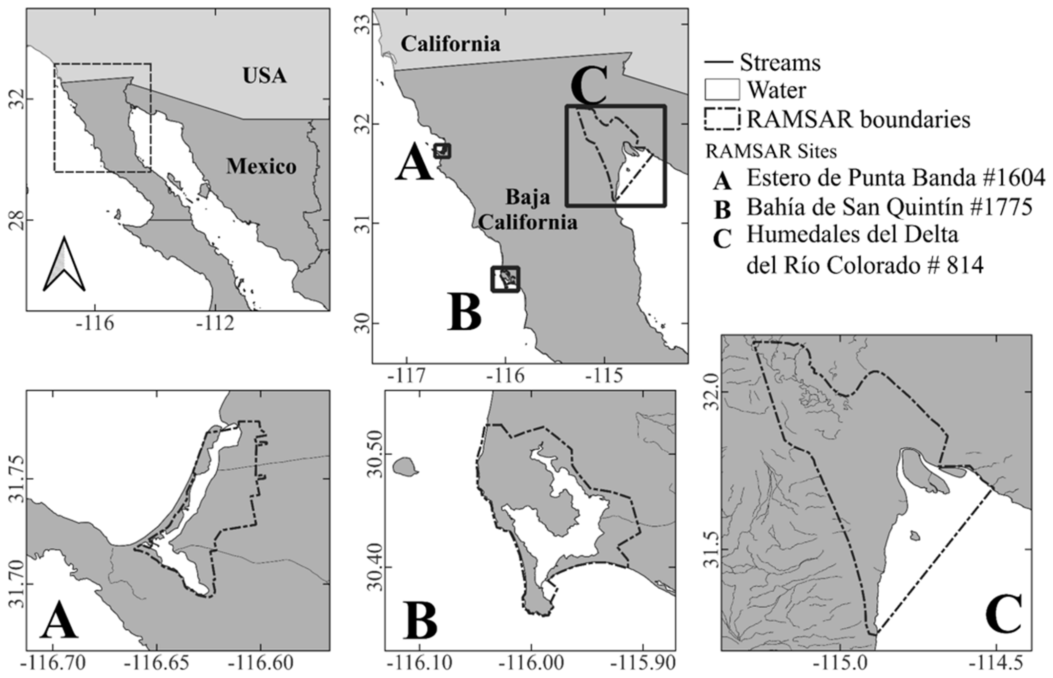
Figure 1. Location of the three study areas in northwestern México and their Ramsar site numbers: (A) Estero de Punta Banda #1604; (B) Bahía de San Quintín #1775; (C) Humedales del Delta del Río Colorado #814.
Birds 07 00051 g001
Figure 2. California black rail (Laterallus jamaicensis coturniculus) photographed at Estero de Punta Banda, Baja California, 27 May 2023, by Hiram Moreno and Héctor Sánchez.
Birds 07 00051 g002
Table 1. Summary of historical records and survey accounts of the California black rail in Baja California and the Colorado River Delta. Detection type: HO = Heard Only, OI = Overheard Incidentally, P = Pair, S = Sighting, SC = Specimen Collected, SI = Single Individual, UP = Unquantified Presence.
Authors, DateDetectionLocationReferences
Nelson & Goldman, 31 August 19051 SCBahía de San Quintín,
San Simón River
[16,23,24]
Museum of Vertebrate Zoology, 3 & 6 April 19252 SCSan Telmo[16,23]
Huey, 6 June 19251 SCSan Ramón[16,25]
Bent, December 19261 HOBahía de San Quintín [23,46]
Huey, June 19271 HOSangre de Cristo[16,25,26]
Jensen, 11 April 19791 SBahía de San Quintín,
Punta Mazo
[15]
Hamilton & Erickson, April 19911 HOBahía de San Quintín,
Punta Azufre
[18]
Tibbits et al., December 19981 SBahía de San Quintín,
Punta Azufre
[47]
Anderson & Bautista, April 2000UPBahía de San Quintín,
Punta Azufre
[47]
San Miguel, 18 July 20011 HOSan Telmo[15]
San Miguel, 19 July 20015 HOSan Telmo[15]
Hinojosa et al.,
25 & 30 May 2001
2 HOLaguna del Indio
&
El Mayor
[19,48]
Ruiz et al., February–December 2002UPSan Telmo[21]
Ruiz et al., February–December 2002UPEl Rosario[21]
USGS Alaska Science Center, 1 March 2002UPBahía de San Quintín,
Punta Mazo
[47]
Erickson & Hamilton, 21 April 20022 HOLower San Telmo[49]
Erickson & Hamilton, 21 April 20021 P + 1 SI
HO
Bahía de San Quintín,
Punta Azufre
[49]
Palacios & Hinojosa, 21–23 April 20024 HOBahía de San Quintín [49]
Hamilton et al., 21 April 20021 HOLower San Telmo[49]
Palacios & Hinojosa, 22 April 20021 HOLower Río El Rosario[49]
Patten, 4–5 May 20021 HOSan Telmo[49]
Erickson et al., 31 May 20021 HOLower San Telmo[15]
Iliff, 12 July 20031 HO + 1 OILower San Telmo[15]
USGS Alaska Science Center, February 2005UPBahía de San Quintín,
Punta Azufre
[47]
Eldemire, 18 February 20051 HOBahía de San Quintín,
Chapala
[15]
Eldemire, 25 February 20051 SBahía de San Quintín,
Punta Azufre
[15]
Zamora, 6 April 20072 HOBahía de San Quintín,
Casona Vieja
[15]
González Bernal, March–April 20088 HOBahía de San Quintín [50]
Vargas & Andrade, 2–3 June 20173 HOBahía de San Quintín,
Chapala
[15]
Hoffman et al., 7–8 February 20241 SBahía de San Quintín,
Chapala
[15]
Trinchan Guerra & Montejo, 21 February 20241 SBahía de San Quintín,
Chapala
[15]
McAndrews & Montejo, 15 July 20241 HOBahía de San Quintín, Estero NW[15]
Mena Páramo & Hernández Álvarez, 16 November 20251 HOBahía de San Quintín [15]
Radamaker & Radamaker, 20 November 20253 SBahía de San Quintín, Cielito Lindo[15]
Kahle et al., 5 December 20252 HOBahía de San Quintín [15]
Table 2. California black rail detections registered during systematic surveys in the Baja California portion of the Colorado River Delta, México, 2000–2022.
SiteSurvey PointsDateNumber of Black Rails
Hardy River16822 March 20001
Laguna del Indio1123 March 20001
Andrade Mesa Wetlands620 March 20042
25 March 20095
22 May 20092
Colorado River1069 March 20101
10 March 20106
16 April 20171
Las Arenitas Wetlands141 March 20221
Total305 20
Table 3. Annual survey detection indices for California black rail for Estero de Punta Banda (EPB) and Bahía de San Quintín (BSQ). Baja California, México, between 2023 and 2025.
SiteYearPoints SurveyedVisits per PointDetectionsDetections per PointDetections per Point-Visit
EPB2023334113.674.56
202433196.332.11
20253393.001
BSQ2023636310.503.50
2024636510.833.61
2025636711.173.72
Note: Detection rates are presented as indices of detection frequency and do not represent the number of unique individuals, as repeated detections across visits cannot be ruled out.
Table 4. California black rail (Laterallus jamaicensis coturniculus) survey detections by month and year totals for Estero de Punta Banda (EPB) and Bahía de San Quintín (BSQ), Baja California, México, during the 2023–2025 breeding seasons. Monthly values represent the total number of detection records obtained during each survey. Highest detections per month are in bold numbers. Annual totals are the sum of all detection records across the three survey visits.
SiteYearMayJuneJulyAnnual Total
EPB202315131341
202466719
20252529
BSQ202312203163
202415193165
202518222767
Table 5. Detection parameters and distance sampling model selection for California black rail surveys at Estero de Punta Banda (EPB) and Bahía de San Quintín (BSQ), 2023–2025. Half-Normal + cosine = HN + C, Hazard Rate + cosine = HR + C, Uniform + cosine = U + C, Akaike Information Criterion = AIC, Effective Detection Radius = EDR, Confidence Interval = CI, Coefficient of Variation = CV, Detection Probability = DP. Selected model and AIC in bold. Monotonicity constrained = *, N = Total number of detection events within each site–year combination.
SiteYearNModelAICEDR (m)EDR 95% CIDetection Probability (p)p 95% CICV (p)Density (ind./ha)D 95% CI
EPB202341HN + C319.4235.8630.55–42.100.200.15–0.280.1611.767.22–19.16
HR + C320.4535.9727.47–47.090.200.12–0.340.2711.696.21–22.01
U + C321.6535.9430.55–42.280.200.15–0.280.1611.717.17–19.12
202419HN + C156.7950.7737.86–68.080.400.23–0.720.282.471.28–4.75
HR + C158.1546.4923.12–93.470.340.09–1.000.682.950.78–11.07
U + C156.5450.6640.53–63.320.400.26–0.620.212.481.44–4.28
20259HN + C75.9574.9732.6–172.420.880.19–1.000.750.730.16–3.39
HR + C76.9973.3655.41–97.120.840.48–1.000.240.760.42–1.38
U + C74.0180.0080.00–80.001.001.00–1.000.000.640.45–0.91
BSQ202363HN + C513.7424.0821.21–27.330.090.07–0.120.1318.9210.87–32.93
HR + C509.1523.5918.18–30.600.090.05–0.150.2619.719.84–39.49
U + C *512.3620.3017.18–23.990.060.05–0.090.1726.6014.77–47.90
202465HN + C542.7024.4419.94–29.970.100.06–0.140.2019.2410.39–35.62
HR + C543.6728.0921.66–36.420.120.07–0.210.2614.577.35–28.91
U + C544.9725.8221.21–31.440.100.07–0.150.2017.249.39–31.67
202567HN + C547.7728.4423.85–33.910.130.09–0.180.1814.219.39–21.51
HR + C545.2129.8123.08–38.510.140.08–0.230.2612.947.46–22.42
U + C547.9030.525.96–35.830.150.11–0.200.1612.368.36–18.26
Disclaimer/Publisher’s Note: The statements, opinions and data contained in all publications are solely those of the individual author(s) and contributor(s) and not of MDPI and/or the editor(s). MDPI and/or the editor(s) disclaim responsibility for any injury to people or property resulting from any ideas, methods, instructions or products referred to in the content.