
Proceeding Paper

Canyon-Induced Fire Acceleration and Its Integration in an Eruptive Fire Early Warning System †
Center for Wildfire Research, Faculty of Electrical Engineering, Mechanical Engineering and Naval Architecture (FESB), University of Split, 21000 Split, Croatia
*
Author to whom correspondence should be addressed.
Presented at the 2nd International Workshop on Extreme Wildfire Events (X-Fire 2026), Prague, Czech Republic, 23–25 June 2026.
Environ. Earth Sci. Proc. 2026, 46(1), 10; https://doi.org/10.3390/eesp2026046010
Published: 9 July 2026

Abstract

Eruptive fire behavior is one of the most hazardous forms of extreme wildfire dynamics and has caused numerous firefighter fatalities. Early identification of high-risk conditions and locations is essential for improving operational safety. The Croatian Advanced Wildfire Surveillance System includes an Eruptive Fire Early Warning System that provides real-time assessment of eruptive fire potential. While earlier versions classified risk based on slope, aspect, meteorological conditions, and vegetation, the new version introduces an additional overlay layer incorporating canyon geometry as a key factor in accelerating fire spread. The proposed operational approach integrates experimentally derived canyon geometry thresholds with terrain analysis from Digital Elevation Model (DEM)-derived GIS layers in order to identify locations with increased eruptive fire potential.

1. Introduction

Eruptive fire behavior is one of the most dangerous forms of extreme wildfire dynamics and has caused numerous firefighter fatalities. Identifying locations where such behavior may occur is therefore essential for reducing operational risk. Within the Croatian Advanced Wildfire Surveillance System [1], an Eruptive Fire Early Warning System [2] provides real-time alerts of potential eruptive fire events. The previous version defined five risk classes based on meteorology, vegetation, and topology (slope and aspect). The new version introduces an additional warning layer related to canyon geometry and fire–atmosphere interaction processes associated with confined terrain.

2. Methods

Eruptive fire spread—also referred to as blow-up or flashover fire—has been extensively studied since the seminal work of Viegas et al. [3,4] in the early 21st century. It may be slope-driven or wind-driven, although it is most commonly associated with fire acceleration due to terrain slope. This framework underlies the five eruptive fire risk classes in the Croatian Eruptive Fire Early Warning System [2], which are based on terrain (slope and aspect), meteorological conditions, and vegetation type (light, low-buoyancy fuels such as grass and shrub). However, only slope and aspect were previously included among terrain factors. As noted by Viegas et al. [3], canyon-shaped terrain can generate a chimney effect and strong fire–atmosphere coupling responsible for numerous fatal accidents worldwide. This underscores the need to incorporate canyon-induced fire acceleration into the warning system, which is the focus of this study.

3. Results and Discussion

In 1995, Lopes et al. [5] developed a numerical model to analyze the influence of canyon geometry on fire spread and concluded that the rate of spread in canyons is significantly higher than on a simple planar slope with the same inclination. This finding was later confirmed experimentally by Viegas et al. [4] and further supported by other authors [6,7]. Based on these studies, we improved the Croatian Eruptive Fire Early Warning System by introducing a new canyon-related warning class. The central methodological challenge was to define canyon geometry in a manner suitable for operational implementation. A canyon is primarily characterized by two angles: the central slope angle α and the lateral slope angle δ. For eruptive fire behavior, the canyon length l is also a relevant parameter. If the canyon is not sufficiently long, eruptive fire behavior may not fully develop. Therefore, the first step is to analyze the landscape, identify canyon-shaped landforms, and determine the parameters α, δ and l. The methodology for automatic canyon detection from DEM-derived GIS layers will be a topic of another paper [8]. In the present study, we focus on defining the threshold values of α, δ and l required to identify canyons with potential for eruptive fire development.
According to experimental research, particularly the most recent study [7], critical conditions for eruptive fire behavior are: α ≥ 27.5° and δ ≥ 20°. Because eruptive fire occurrence is more strongly dependent on α than on δ and because higher values of α allow eruptive behavior even at lower δ values, it has been shown that for α ≥ 30° eruptive fire behavior occurs for δ ≥ 10° [7]. Based on these findings, we adopted the following operational criteria:
(1)
If α ≥ 25° → potential eruptive fire caused by terrain slope [2];
(2)
If α ≥ 27.5° and δ ≥ 20° or α ≥ 30° and δ ≥ 10° → potential canyon-induced eruptive fire.
The integration of canyon length l is more complex because it depends on the initial rate of fire spread at the canyon entrance. For α = 27.5° and δ = 20°, the dimensionless rate of spread R′ (defined as the ratio between the instantaneous rate of spread and the initial rate of spread) increases rapidly after approximately 100 s [7]. To determine the critical canyon length, an estimate of the average rate of spread is required. Based on simulations of 1853 fires reported in [9], the average rate of spread was 0.55 km/h (0.153 m/s), varying from 0.42 km/h in shrub areas to 0.66 km/h in timber areas. Over 100 s, the average fire front advances approximately 15 m. Therefore, a first-order estimate of the critical canyon length is l ≥ 15 m. However, this threshold also depends on DEM spatial resolution, since canyon detection is based primarily on slope and aspect maps derived from DEM data.
Areas identified as canyons with potential for eruptive fire behavior are not included as a separate class in the eruptive fire early warning map, but are instead provided as an additional overlay layer.
A preliminary implementation over Croatian coastal terrain identified multiple canyon-shaped landforms satisfying the proposed criteria, particularly in steep Mediterranean karst landscapes. Comparison with the previous warning model shows that the canyon overlay highlights terrain configurations not captured by slope-only analysis and therefore provides additional operational information for firefighter situational awareness.
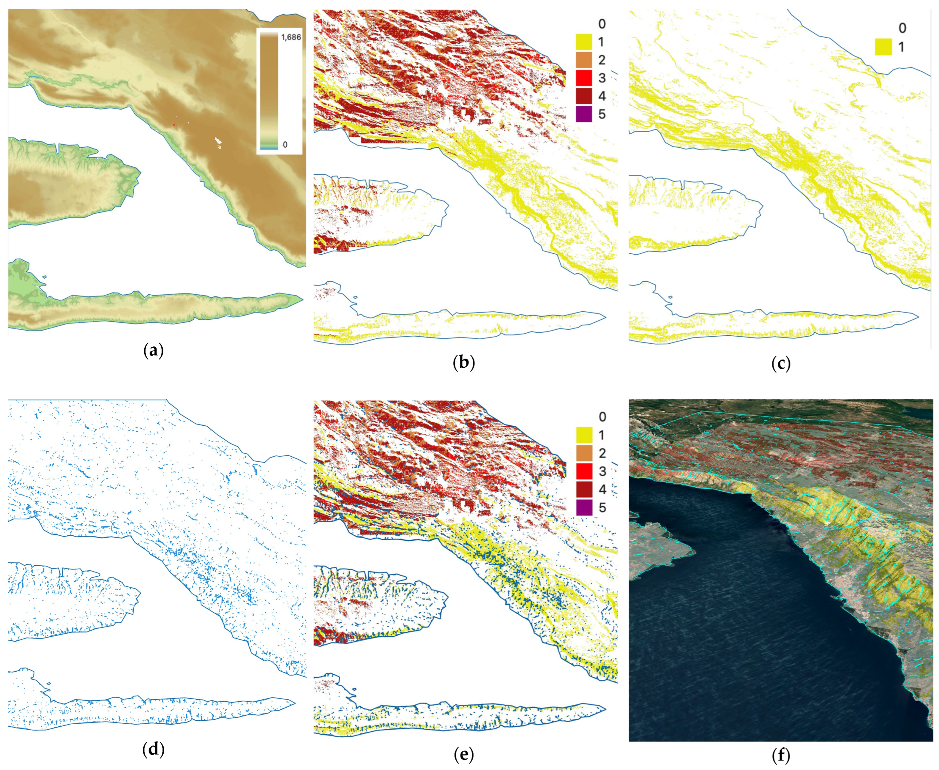
Figure 1 shows an example from Split-Dalmatia County. It presents an eruptive fire early warning map (EFWM) for 30 July 2024, when a huge fire occurred close to Tučepi, as well as other related layers including detected canyons.
The proposed thresholds should nevertheless be interpreted as operational approximations because canyon detection sensitivity depends on DEM spatial resolution, terrain smoothing, and fuel distribution variability. Higher-resolution DTMs improve the identification of narrow canyon structures, while coarse-resolution terrain models may underestimate canyon geometry. Fuel continuity and wind exposure may additionally influence eruptive fire development and will be addressed in future validation studies.
The canyon overlay is therefore designed as a supplementary warning layer integrated with existing meteorological, vegetation, and topographic risk components rather than as an independent predictor.

4. Conclusions

Canyon landform geometry is a critical terrain factor that enhances eruptive effects and accelerates fire spread. For this reason, the Croatian Eruptive Fire Early Warning System has been improved by introducing an additional warning overlay layer that incorporates canyon geometry. A quantitative canyon definition based on geometric parameters (α, δ, and l) has been proposed, together with threshold values suitable for operational implementation. This approach enables the identification of terrain configurations with increased potential for canyon-induced eruptive fire behavior and contributes to improved firefighter safety and risk mitigation.
The new layer complements existing meteorological, vegetation, slope, and aspect components of the warning system and enables the identification of terrain configurations with increased potential for canyon-induced eruptive fire behavior. This contributes to improved firefighter safety, situational awareness, and operational risk mitigation.

Author Contributions

Conceptualization, D.S. and A.I.; methodology, D.S.; software, A.I. and M.B.; validation, M.B., L.Š. and D.K.; formal analysis, A.I.; investigation, D.S. and M.B.; resources, A.I.; writing—original draft preparation, D.S.; writing—review and editing, D.S.; visualization, A.I.; supervision, D.K.; project administration, L.Š.; funding acquisition, L.Š. All authors have read and agreed to the published version of the manuscript.

Funding

This research was partly funded by project “FireDT—Digital Fire Twin: Operational Risk Assessment and Recommendation System for Split-Dalmatia County”, grant number PK.3.4.17.0014 (ERDF—European Regional Development Fund).

Institutional Review Board Statement

Not applicable.

Informed Consent Statement

Not applicable.

Data Availability Statement

The data presented in this study are available upon request from the corresponding author.

Conflicts of Interest

The authors declare no conflicts of interest. The funders had no role in the design of the study; in the collection, analyses, or interpretation of data; in the writing of the manuscript; or in the decision to publish the results.

References

  1. OiV Fire Detect AI. Available online: https://oiv.hr/en/services-and-platforms/oiv-fire-detect-ai/ (accessed on 5 February 2026).
  2. Stipaničev, D.; Bugarić, M.; Šerić, L.; Krstinić, D. Eruptive Fire Early Warning System. In Proceedings of the NERO X-Fire 2025, 1st International Workshop on Extreme Wildfire Events, Nicosia, Cyprus, 23–25 September 2025. [Google Scholar]
  3. Viegas, D.X.; Pita, L.P.; Matos, L.; Palheiro, P. Slope and Wind Effect on Fire Spread. In Forest Fire Research & Wildland Fire Safety, 1st ed.; Viegas, D.X., Ed.; Millpress: Rotterdam, The Netherlands, 2002; p. 16. [Google Scholar]
  4. Viegas, D.X. Slope and Wind Effects on Fire Propagation. Int. J. Wildland Fire 2004, 13, 143–156. [Google Scholar] [CrossRef]
  5. Lopes, A.M.G.; Sousa, C.M.; Viegas, D.X. Numerical simulation of turbulent flow and fire propagation in complex topography. Numer. Heat Transf. J. 1995, 27, 229–253. [Google Scholar] [CrossRef]
  6. Viegas, D.X.; Pita, L.P. Fire spread in canyons. Int. J. Wildland Fire 2004, 13, 253–274. [Google Scholar] [CrossRef]
  7. Fan, J.; Bouxan, C.; Yan, G.; Bu, C.; Gao, J.; Dou, X.; Hu, H.; Sun, L.; Hu, T. Experimental study on the evolution of canyon fire spread behavior under different terrains and the critical conditions for eruptive fire. Int. J. Wildland Fire 2025, 34, WF24134. [Google Scholar] [CrossRef]
  8. Stipaničev, D.; Ivanda, A.; Bugarić, M.; Šerić, L.; Krstinić, D. Canyon Detection for Eruptive Fire Early Warning System. In Proceedings of the 10th International Conference on Forest Fire Research (ICFFR 2026), Coimbra, Portugal, 31 October–6 November 2026. [Google Scholar]
  9. Cardil, A.; Monedero, S.; SeLegue, P.; Navarrete, M.Á.; de-Miguel, S.; Purdy, S.; Marshall, G.; Chavez, T.; Allison, K.; Quilez, R.; et al. Performance of operational fire spread models in California. Int. J. Wildland Fire 2023, 32, 1492–1502. [Google Scholar] [CrossRef]
Figure 1. (a) Digital Elevation Model (DEM) of area around Tučepi in Split-Dalmatia County where a big fire occurred on 30 July 2024; (b) fire early warning map (EFWM) for 30 July 2024; (c) binary map for EFWM Class I—slope steeper than 25°; (d) binary map of detected canyon satisfying canyon boundary conditions (2); (e) canyon layer superimposed on EFWM as a separate layer; (f) canyon layer superimposed on EFWM presented in Google Earth satellite image.
Eesp 46 00010 g001
Disclaimer/Publisher’s Note: The statements, opinions and data contained in all publications are solely those of the individual author(s) and contributor(s) and not of MDPI and/or the editor(s). MDPI and/or the editor(s) disclaim responsibility for any injury to people or property resulting from any ideas, methods, instructions or products referred to in the content.