1. Introduction
Electric bicycles (e-bikes) are increasingly positioned as a low-emission and space-efficient mode for short urban trips, last-mile access and lightweight urban logistics. Their relevance has been reinforced by post-pandemic changes in travel behaviour and by the need for flexible alternatives to car-based travel [
1,
2]. Although e-bikes reduce physical effort through motor assistance, their practical performance remains constrained by battery range, rider comfort and local topography [
3,
4].
In hilly urban areas, road slope becomes a decisive energy variable. Positive gradients increase gravitational resistance and battery demand, whereas negative gradients may create regenerative recovery potential under suitable braking and control conditions [
5,
6]. Previous electric-mobility and e-bike studies show that slope, speed, rolling resistance and aerodynamic drag can substantially influence energy use, making planned-route characteristics more informative than average consumption values alone [
7,
8,
9,
10].
Conventional routing systems generally prioritize distance or travel time [
11]. This can misrepresent e-bike performance because a short but steep connector may require more energy than a longer, flatter alternative. Similarly, a downhill corridor may reduce net energy demand when regenerative recovery is available. Therefore, e-bike planning requires spatially explicit segment-level energy indicators rather than only network-level averages.
This study develops a GIS-based framework for mapping slope-dependent energy consumption and recovery in an urban e-bike network. The contribution is the transformation of segment-level energy calculations into thematic GIS/Folium layers that identify consumption-intensive segments, recovery corridors, net-energy patterns and transitions. These outputs provide a decision-support basis for municipalities, micromobility operators and route-planning applications.
2. Materials and Methods
2.1. Data Processing
The data processing stage transformed the raw spatial datasets into a directed, segment-level road network suitable for slope-dependent e-bike energy analysis. The study was conducted on an urban road network representing short-distance e-bike travel in a topographically variable neighbourhood context in Ankara, Türkiye. Because the energetic behaviour of a road segment changes according to travel direction, the network was represented as directed segments. This allows the same physical road segment to be evaluated differently when traversed uphill or downhill.
The input data consisted of a vector road network and elevation information derived from a digital elevation model (DEM). Each road segment was assigned geometric attributes, including segment length and endpoint coordinates. DEM-based elevation values were then extracted for the start and endpoints of each segment. The elevation difference between these endpoints was divided by the horizontal segment length to calculate the average segment slope. Accordingly, the slope values represent segment-level analytical approximations rather than direct field measurements.
Following slope calculation, energy-related indicators were computed for each segment, including energy consumed, energy regained, and net energy. These indicators were subsequently used to generate GIS-based thematic maps and to identify spatial patterns of energy burden and recovery potential. The input data and derived variables used in the framework are summarized in
Table 1. Spatial processing and thematic visualization were implemented in Python 3.14.7 using the open-source Folium library.
2.2. Segment-Level Energy Model
For each directed road segment, energy demand and regenerative recovery potential were estimated using a physics-informed segment-level model. The model combines the main resistive and assisting components that affect e-bike movement on sloped roads, namely gravitational resistance, rolling resistance, aerodynamic drag and regenerative braking recovery. This modelling structure is consistent with previous electric mobility and e-bike energy studies, which show that road gradient, vehicle–rider mass, rolling resistance, aerodynamic drag and speed-dependent forces jointly determine segment-level energy requirements [
5,
7,
12]. The main parameters used in the calculations are listed in
Table 2.
The segment-level energy model was formulated using the parameter values in
Table 2. For a road segment with length d, slope angle θ, total mass m, gravitational acceleration g, rolling resistance coefficient Crr, aerodynamic drag coefficient Cd, frontal area A, and air density ρ, the energy components were calculated as follows.
The gravitational energy component represents the energy associated with elevation change along the segment:
The rolling resistance energy component represents the energy required to overcome tyre–road contact resistance:
The aerodynamic drag energy component represents the energy required to overcome air resistance during motion:
For downhill segments, the potential regenerative energy recovery was estimated from the recoverable portion of gravitational potential energy:
Accordingly, the consumed energy for each segment was calculated as the sum of the gravitational, rolling resistance and aerodynamic drag components:
For downhill movement, regenerative recovery was subtracted from the consumed energy to obtain the net segment-level energy value:
Positive Enet values indicate net energy consumption, whereas negative Enet values indicate that the estimated regenerative recovery exceeds the energy required to traverse the segment under the assumed model parameters. This distinction is important for GIS-based mapping because uphill and downhill movements on the same physical road segment may produce different energy outcomes. The use of a directed segment representation therefore enables the model to capture direction-sensitive energy behaviour. The model is intentionally parsimonious because the objective is to generate a reproducible GIS decision-support layer rather than fully calibrated field measurements. Traffic, rider behaviour, stop-and-go dynamics, battery state of charge and weather conditions were therefore not explicitly modelled and should be addressed in future validation.
2.3. GIS-Based Mapping Workflow
The GIS-based mapping workflow was designed to translate segment-level energy calculations into interpretable spatial decision-support outputs (
Figure 1). The workflow integrates five main stages: road-network preparation, DEM-based elevation extraction, slope calculation, segment-level energy modelling, and GIS/Folium-based thematic visualization. First, the road network was structured as directed segments to preserve the effect of travel direction on uphill and downhill movement. Then, elevation values were assigned to segment endpoints using DEM-derived height information, and average slope values were calculated for each segment based on elevation difference and horizontal length.
After the slope values were obtained, the segment-level energy model was applied to each directed road segment. Three primary energy indicators were calculated: energy consumed, energy regained through potential regenerative braking, and net energy. These indicators were then joined back to the spatial road layer and visualized as separate thematic maps. This workflow enables the spatial distribution of energy demand and recovery potential to be examined at the road-segment level rather than as a single aggregate route value.
The resulting GIS outputs provide a practical basis for identifying energy-demand hotspots, downhill recovery corridors, and movement directions with favourable or unfavourable net-energy behaviour. In this sense, the workflow operates as a GIS-based decision-support approach for energy-aware e-bike mobility planning, particularly in urban areas where slope and directionality strongly affect travel performance.
3. Results and Discussion
The GIS/Folium thematic maps demonstrate that e-bike energy performance is spatially heterogeneous across the analyzed urban road network. Energy values differ considerably between neighbouring road segments because they are shaped by slope direction, segment length, gravitational resistance, rolling resistance, and aerodynamic drag. This finding is consistent with previous electric mobility studies showing that road gradient and speed-dependent resistive forces are important determinants of segment-level energy demand [
5,
6,
12].
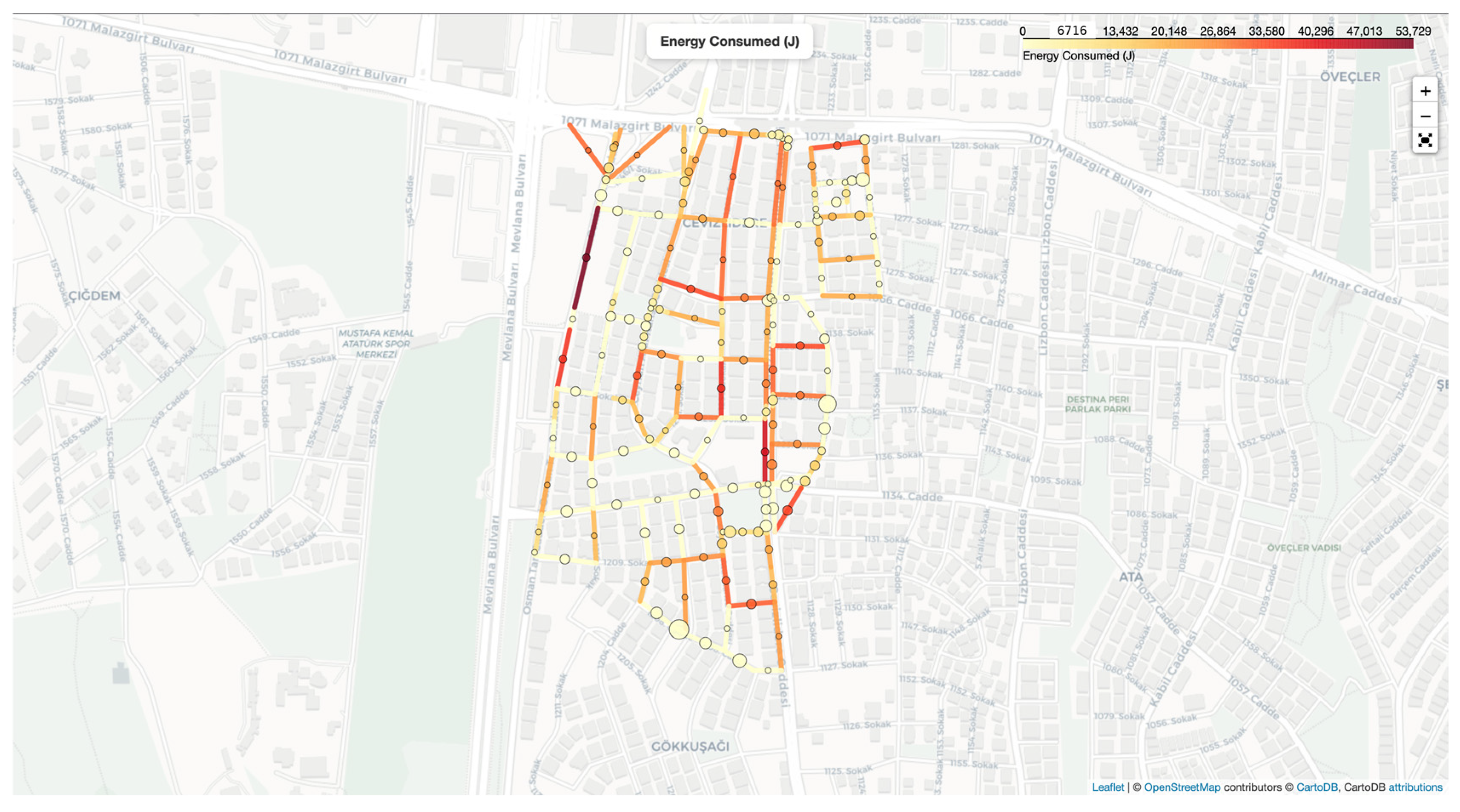
The energy consumed map shown in
Figure 2 identifies road segments where e-bike movement requires relatively high energy input. These segments generally correspond to uphill or resistance-intensive links where gravitational resistance increases the mechanical work required for movement. From a planning perspective, such segments can be interpreted as potential battery-demand hotspots or physically demanding links for riders. Their identification is important because distance-based route evaluation alone may fail to reveal short but energetically costly uphill transitions.
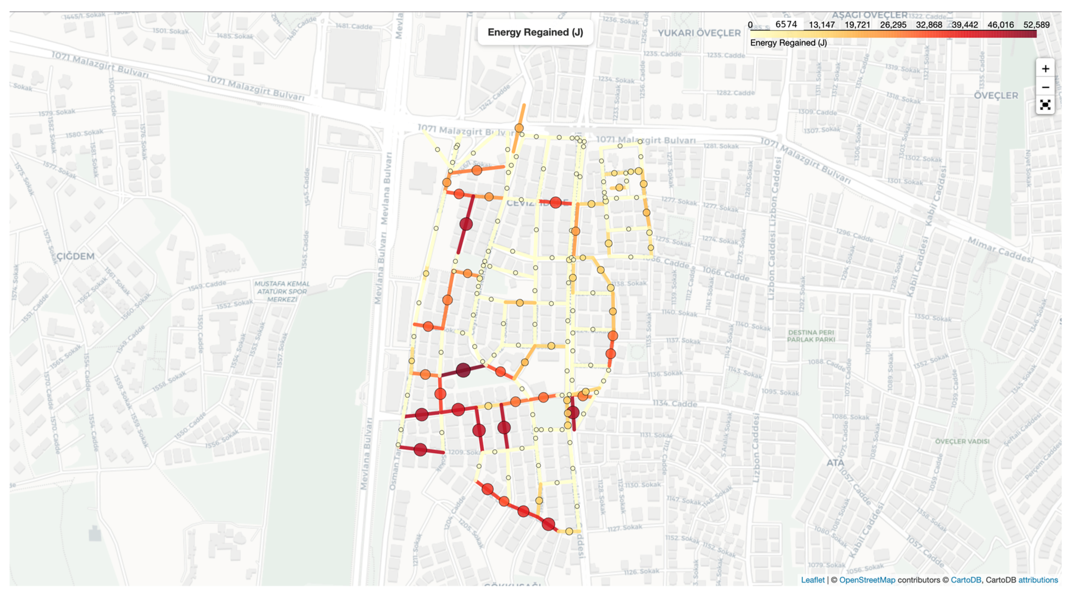
The energy regained map presented in
Figure 3 highlights downhill segments where regenerative braking may theoretically contribute to energy recovery. Unlike the energy consumed layer, this map does not represent measured battery charging in the field; rather, it indicates the spatial potential for regenerative recovery under the assumed model parameters. The distribution of these segments shows that topography can act not only as an energy cost factor but also as a recoverable spatial resource when downhill movement and directionality are explicitly modelled. This interpretation is in line with previous studies emphasizing the relevance of regenerative braking and slope-aware modelling in electric mobility systems [
7,
12,
13].
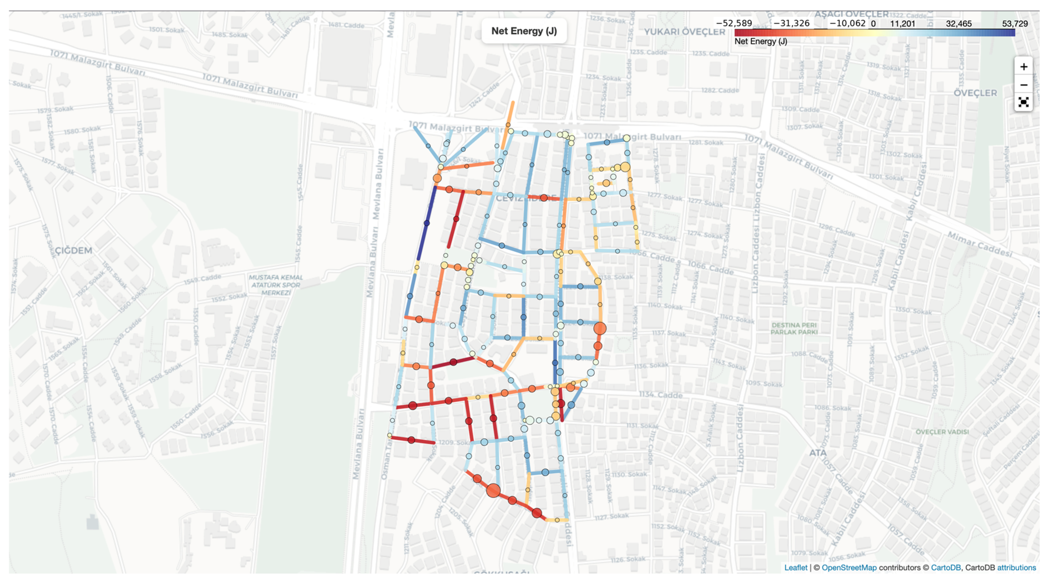
The net energy map in
Figure 4 integrates the effects of energy consumption and regenerative recovery. It therefore provides a more comprehensive spatial interpretation than the consumed or regained layers alone. Positive net-energy values indicate movement directions where energy demand remains dominant, while lower or negative net-energy values indicate segments where potential recovery offsets part of the consumed energy. This layer is particularly useful for distinguishing energy-disadvantaged movement directions from corridors that may be more favourable for e-bike travel.
Three thematic maps show that nearby roads may produce very different energy outcomes depending on slope direction and local topographic structure. This has direct implications for e-bike route guidance and micromobility planning. In hilly urban environments, the shortest or fastest path may not necessarily correspond to the most energy-efficient path. Instead, a slightly longer route may reduce battery burden if it avoids steep uphill segments or includes downhill links with recovery potential.
Table 3 summarizes the planning relevance of the three GIS-based energy layers. Overall, these results support the broader argument that e-bike route evaluation should incorporate energy-related spatial indicators rather than relying only on distance or travel time.
From a GIS perspective, the main output is a set of spatial decision-support layers rather than a single aggregate energy value. These layers can help planners locate segments where infrastructure improvements or alternative routing guidance may reduce energy burden; they can also help operators assess whether service areas include topographic barriers that may reduce battery reliability.
The recovery map should be interpreted as a potential layer rather than a measured field outcome. Actual regenerative recovery depends on motor type, braking behaviour, battery state of charge, control logic and road safety conditions. Nevertheless, the outputs demonstrate how segment-level energy modelling can make topographic effects visible and operational for urban micromobility planning.
Despite these contributions, three main limitations should be acknowledged. First, the segment-level energy model was formulated under idealized, physics-based assumptions and does not explicitly represent regenerative braking control strategies; road-related factors such as speed fluctuation, traffic flow and road-surface adhesion were also excluded from the formulation. Second, the reported results are derived from a single set of model parameters representing one general e-bike and rider configuration; variations across e-bike models, motor characteristics and rider behaviour were not considered, which may limit the generalizability of the observed energy patterns. Third, evaluating road segments solely through energy consumption and recovery indicators does not provide a comprehensive assessment of routing or control-strategy performance; a multi-dimensional index that jointly incorporates energy efficiency, safety and riding comfort is recommended for future GIS-based decision-support frameworks.
4. Conclusions
This paper presented a GIS-based segment-level framework for mapping slope-dependent energy consumption and regenerative recovery in an urban e-bike network. By combining road geometry, DEM-derived elevation information and a simplified physics-based energy model, the study produced thematic maps for energy consumed, energy regained, and net energy. The results show that distance-based interpretation alone is insufficient for e-bike planning in topographically variable environments because nearby segments may have substantially different energy profiles.
The main contribution is the translation of segment-level energy calculations into spatially interpretable decision-support layers. The energy-consumption map identifies local burdens, the recovery map highlights potential downhill recovery corridors, the net-energy map reveals critical energy-intensive links. Together, these outputs can support municipalities, operators and navigation services in evaluating energy-aware corridors, improving route guidance and designing more user-centred micromobility strategies.
Future work should calibrate the model using GPS, speed, elevation, battery and rider-behaviour observations. Higher-resolution DEMs, sub-segment slope profiles, traffic conditions, stop-and-go events and weather variables should also be incorporated to improve empirical validity. The framework can further be extended toward multi-criteria route optimization where energy, distance, travel time, safety and rider comfort are jointly evaluated.
Author Contributions
Conceptualization, E.T., G.Ö. and S.N.Ç.; methodology, E.T. and G.Ö.; software, E.T.; formal analysis, E.T.; investigation, E.T.; data curation, E.T.; writing—original draft preparation, E.T.; writing—review and editing, G.Ö. and S.N.Ç.; visualization, E.T.; supervision, G.Ö. and S.N.Ç. All authors have read and agreed to the published version of the manuscript.
Funding
This research was conducted within the framework of TÜBİTAK 2244 Project No. 119C200, coordinated by Prof. Dr. Alper Çabuk.
Institutional Review Board Statement
Not applicable.
Informed Consent Statement
Not applicable.
Data Availability Statement
The data used in this study are available from the corresponding author upon reasonable request. Restrictions may apply to the redistribution of proprietary road-network data.
Conflicts of Interest
The authors declare no conflicts of interest.
Abbreviations
| DEM | Digital Elevation Model |
| E-bike | Electric Bicycle |
| GIS | Geographic Information Systems |
References
- Settey, T.; Gnap, J.; Beňová, D.; Pavličko, M.; Blažeková, O. The growth of e-commerce due to COVID-19 and the need for urban logistics centers using electric vehicles: Bratislava case study. Sustainability 2021, 13, 5357. [Google Scholar] [CrossRef] [Scilit]
- van der Drift, S.; Wismans, L.; Olde Kalter, M.J. Changing mobility patterns in the Netherlands during COVID-19 outbreak. J. Locat. Based Serv. 2022, 16, 1–24. [Google Scholar] [CrossRef] [Scilit]
- Melo, S.; Baptista, P. Evaluating the impacts of using cargo cycles on urban logistics: Integrating traffic, environmental and operational boundaries. Eur. Transp. Res. Rev. 2017, 9, 30. [Google Scholar] [CrossRef] [Scilit]
- Bell, M.G.H. Future directions in city logistics. In Global Logistics and Supply Chain Strategies for the 2020s: Vital Skills for the Next Generation; Springer: Cham, Switzerland, 2022; pp. 175–189. [Google Scholar]
- Liu, K.; Yamamoto, T.; Morikawa, T. Impact of road gradient on energy consumption of electric vehicles. Transp. Res. Part D Transp. Environ. 2017, 54, 74–81. [Google Scholar] [CrossRef] [Scilit]
- Zhang, Y.; Zhang, Y.; Liu, Z.; Chen, J.; You, T.; Du, C. An eco-cruise control for electric vehicles moving on slope road with constant speed. J. Adv. Transp. 2021, 2021, 9562560. [Google Scholar] [CrossRef] [Scilit]
- Burani, E.; Cabri, G.; Leoncini, M. An algorithm to predict e-bike power consumption based on planned routes. Electronics 2022, 11, 1105. [Google Scholar] [CrossRef] [Scilit]
- Aprigliano, V.; Toro, C.; Rojas, G.; Bastías, I.; Cardoso, M.; Santos, T.; da Silva, M.A.V.; Bustos, E.; de Oliveira, U.R.; Seriani, S. Mapping the Dream: Designing Optimal E-Bike Routes in Valparaíso, Chile, Using a Multicriteria Analysis and an Experimental Study. ISPRS Int. J. Geo-Inf. 2025, 14, 38. [Google Scholar] [CrossRef] [Scilit]
- Furth, P.G.; Sadeghinasr, B.; Miranda-Moreno, L. Slope stress criteria as a complement to traffic stress criteria, and impact on high comfort bicycle accessibility. J. Transp. Geogr. 2023, 112, 103708. [Google Scholar] [CrossRef] [Scilit]
- Łukawska, M. Quantitative modelling of cyclists’ route choice behaviour on utilitarian trips based on GPS data: Associated factors and behavioural implications. Transp. Rev. 2024, 44, 1045–1076. [Google Scholar] [CrossRef] [Scilit]
- Sajadi-Alamdari, S.; Voos, H.; Darouach, M. Ecological advanced driver assistance system for optimal energy management in electric vehicles. IEEE Intell. Transp. Syst. Mag. 2020, 12, 92–109. [Google Scholar] [CrossRef] [Scilit]
- Sadeq, T.; Chew, K.; Morris, E.; Tarboosh, Q.; Aydogdu, O. Optimal control strategy to maximize the performance of hybrid energy storage system for electric vehicle considering topography information. IEEE Access 2020, 8, 216994–217007. [Google Scholar] [CrossRef] [Scilit]
- Erener, A.; Şirin, A. Python-based evaluation of road network constraints for electric scooters and micromobility planning. Int. J. Eng. Geosci. 2024, 9, 34–48. [Google Scholar] [CrossRef] [Scilit]
| Disclaimer/Publisher’s Note: The statements, opinions and data contained in all publications are solely those of the individual author(s) and contributor(s) and not of MDPI and/or the editor(s). MDPI and/or the editor(s) disclaim responsibility for any injury to people or property resulting from any ideas, methods, instructions or products referred to in the content. |