Proceeding Paper

Validating TIR-Derived Total Column Water Vapor Using Sun Photometers and GPS Measurements †

by
Ilias Agathangelidis
1,*,
Yifang Ban
2,
Constantinos Cartalis
1 and
Konstantinos Philippopoulos
1
1
Department of Physics, National and Kapodistrian University of Athens, 15784 Athens, Greece
2
Division of Geoinformatics, KTH Royal Institute of Technology, 10044 Stockholm, Sweden
*
Author to whom correspondence should be addressed.
Presented at the 17th International Conference on Meteorology, Climatology, and Atmospheric Physics—COMECAP 2025, Nicosia, Cyprus, 29 September–1 October 2025.
Environ. Earth Sci. Proc. 2025, 35(1), 6; https://doi.org/10.3390/eesp2025035006
Published: 8 September 2025

Abstract

Total column water vapor (TCWV) is essential for assessing Earth’s radiation budget and hydrological cycle and plays a crucial role in accurate Land Surface Temperature (LST) retrieval from thermal infrared (TIR) imagery. Although TCWV is commonly estimated using near-infrared or microwave observations, TIR-based methods offer an efficient alternative; however, their long-term validation remains limited. This study evaluates TCWV retrieval from Landsat 8/9 Thermal Infrared Sensor (TIRS) using an updated version of the Modified Split-Window Covariance-Variance Ratio (MSWCVR) method, implemented on the Google Earth Engine platform, across Europe. Validation is conducted using AERONET sun photometer measurements (2013–2024) and GPS-based TCWV estimates enhanced with meteorological inputs (2020). Retrieval accuracy is evaluated analyzed in relation to seasonal variations, surface characteristics (e.g., land cover, altitude) and background climate. Results demonstrate robust performance of the TIR-based method, with an average Mean Absolute Error (MAE) of 0.6 gr/cm2 across stations and datasets, supporting its applicability for LST retrieval and broader environmental monitoring applications.

1. Introduction

Total Column Water Vapor (TCWV), also known as Integrated Water Vapor (IWV) or Total Precipitable Water (TPW), is recognized as one of the Essential Climate Variables (ECVs) of the Global Climate Observing System [1] due to its critical role in various Earth system processes. As the primary contributor to energy redistribution through latent heat transport and the dominant source of infrared opacity in the atmosphere, water vapor affects a wide range of meteorological, climatological, and hydrological processes across various spatial and temporal scales, including climate variability, the global water cycle, and extreme weather events [2]. Being the most abundant natural greenhouse gas, water vapor plays a central role in climate feedback mechanisms [3], amplifying the effects of climate change. TCWV is also a critical input for numerous remote sensing applications; it is essential for correcting atmospheric absorption effects and is widely used in retrieving Land Surface Temperature (LST) through split-window algorithms [4,5]. Additionally, water vapor influences radiative forcing by affecting cloud microphysical processes and by modifying the size, shape, and chemical composition of aerosols [6]. Near-real-time TCWV measurements are also valuable for operational weather forecasting, particularly in the context of localized heavy rainfall prediction [7].
Several methodologies have been developed in recent years to obtain accurate estimations of TCWV. Among them, the Global Navigation Satellite System (GNSS), including the Global Positioning System (GPS), has proven to be robust source of high-accuracy TCWV data [8]. This is achieved through the processing of GPS signals to estimate the zenith path delay, which is directly dependent on atmospheric humidity [9]. Another approach involves measuring water vapor transmittance using direct solar irradiance in spectral channels located within water vapor absorption zones. The relatively low cost and ease of deployment of sun photometers have facilitated the development of several global observational networks over the past decades, with the most prominent examples being the AErosol RObotic NETwork (AERONET) [10]. Additionally, water vapor can be retrieved from satellite-based observations across various spectral regions due to its distinct spectroscopic absorption features [11]. These include the visible [12], near-infrared [13], thermal infrared [14], and microwave [15] spectral domains.
TIR-based TCWV retrieval offers several advantages over other spectral wavelengths, including consistent band availability with LST split-window algorithms, applicability to both daytime and nighttime, relatively high spatial resolution, and retrieval simplicity. Among TIR approaches, the split-window method is one of the most widely used techniques, exploiting the brightness temperature difference between the two split-window bands (typically at 11 μm and 12 μm). Using the assumption that atmospheric properties are spatially invariant for neighbouring pixels across these bands, the split-window covariance-variance ratio (SWCVR) technique formulates a mathematical relationship between the ratio of brightness temperature variances and TCWV [16]. Over the past decades, several refinements have been introduced to improve the accuracy of SWCVR-based retrievals, including the incorporation of physical constraints [17], the development of quadratic polynomial models [14], the integration of surface emissivity information [18], and the application of machine learning techniques [19].
In this study, we assess the performance of TCWV retrieval using long-term Landsat 8 and 9 Thermal Infrared Sensor (TIRS) imagery and a modification of the Modified Split-Window Covariance-Variance Ratio (MSWCVR) method across Europe. Validation is performed using sun photometer data from the AERONET and TCWV estimates derived from GPS observations.

2. Materials and Methods

2.1. TCWV Retrieval Using Landsat 8/9 TIR Channels

TCWV is estimated by integrating the non-linear MSWCVR approach [14] with the emissivity correction method proposed by [18]. The MSWCVR technique assumes that atmospheric conditions remain spatially invariant over a window of N neighboring pixels. Under this assumption, the MSWCVR algorithm adapted for Landsat 8/9 Thermal Infrared Sensor (TIRS) is formulated as [14]
T C W V = c 0 + c 1 τ j τ i + c 2 τ j τ i 2 ,
τ j τ i = ε i ε j k = 1 N T i , k T i , a v g T j , k T j , a v g k = 1 N T i , k T i , a v g 2 ,
where i and j refer to Bands 10 and 11 of Landsat 8/9 TIRS, respectively. τi denotes the atmospheric transmittance of band i, and εi the Land Surface Emissivity (LSE). Ti,k is the brightness temperature at pixel k for band i, Ti,avg is the mean brightness temperature over the N neighboring pixels (for a typical window size N = 10) for the same band. The empirical coefficients are equal to c0 = 9.087, c1 = 0.653, and c2 = −9.674 [14].
The assumption that LSE remains constant over the N neighboring pixels in the original MSWCVR method [14] does not hold for high-resolution sensors such as TIRS. To address this, the emissivity ratio is estimated using NDVI-based thresholds following the approach defined in [18]. All available Landsat 8/9 imagery covering the study area (Figure 1) from 2013 to 2024 were considered. Specifically, the top-of-atmosphere TIRS Bands 10 and 11 from Landsat 8/9 Level-1 Collection 2 data products were used (https://doi.org/10.5066/P975CC9B). All necessary processing steps, including data access, preprocessing (e.g., cloud screening), and application of the MSWCVR method were conducted using the Google Earth Engine platform [20].

2.2. Validation Datasets

AERONET Version 3 Level 2.0 instantaneous precipitable water observations were obtained for 62 stations across Europe (Figure 1). At AERONET stations, TCWV is operationally retrieved from direct sun irradiance measurements using a CIMEL CE318-4 sun–sky radiometer in the water vapor absorption band around 940 nm, through a sun photometry inversion algorithm [10]. Specifically, TCWV is calculated using the following equation for the 940 nm band:
W b = l n V 0 l n V δ a t m m r a m w b
where V0 is the instrument calibration constant, V the instrument response, δatm is the total atmospheric optical depth excluding absorption by water vapor, Tw is the water vapor transmittance, mr is the relative optical air mass, and mw is the relative optical water vapor mass; the coefficients a and b depend on instrument and atmospheric characteristics [6].
Additionally, 5-min temporal resolution TCWV estimates for 1698 stations across Europe (Figure 1) were utilized from a high-quality dataset developed in [8]. This dataset represents an enhancement of the operational GPS-derived TCWV products provided by the Nevada Geodetic Laboratory (NGL), achieved through the incorporation of detailed meteorological information. The retrieval methodology is based on estimating signal delays caused by the nondispersive troposphere as GPS signals travel from satellites to ground receivers [8].

3. Results

AERONET and GPS-based observations are used to validate the updated TIR-based MSWCVR approach across Europe. Table 1 summarizes the overall validation statistics, based on approximately 5980 daily observations from AERONET and 19,811 from GPS stations. Evaluation metrics include the Mean Absolute Error (MAE), Root Mean Square Error (RMSE), mean difference (BIAS), and Pearson correlation coefficient (r).
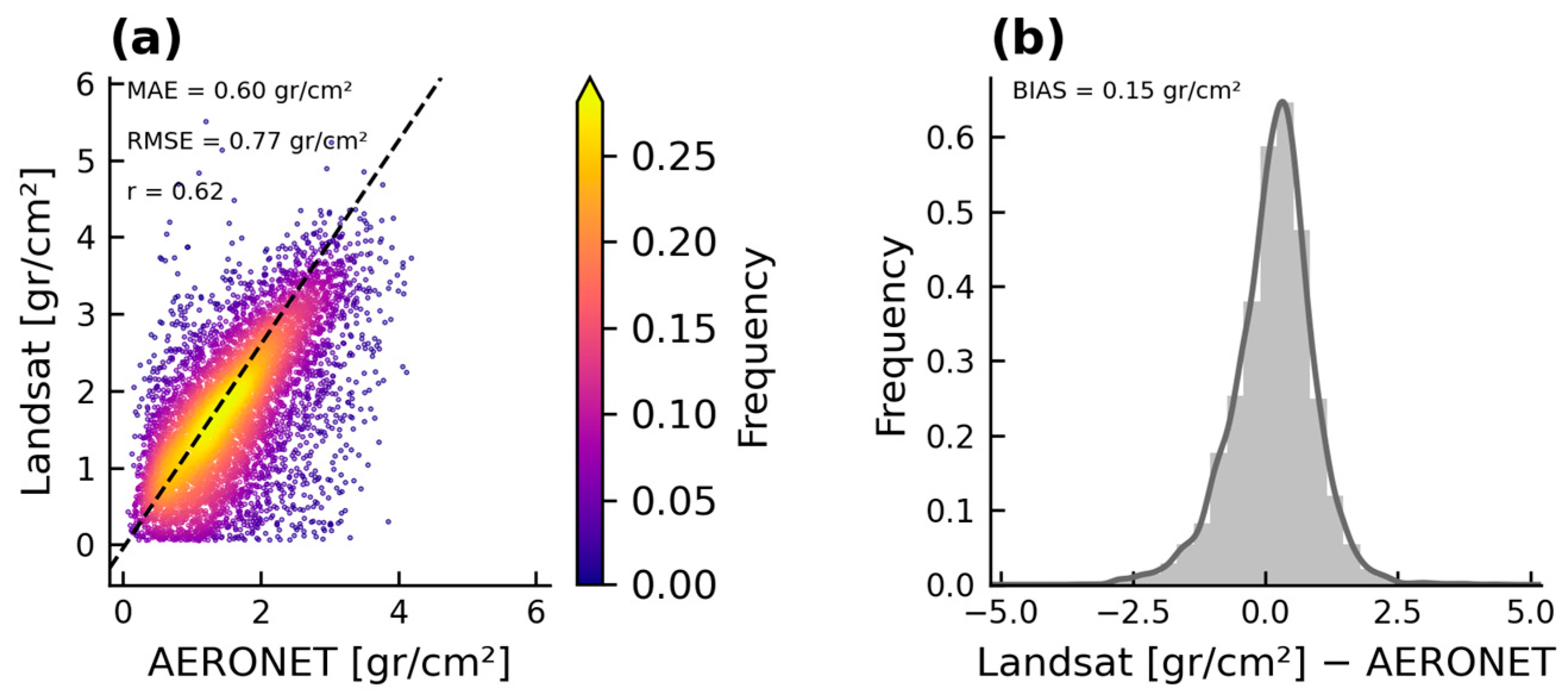
Overall, the results demonstrate satisfactory accuracy of the daily TIR-based retrievals, with low average MAE (approximately 0.6 gr/cm2), minimal positive bias (0.14 gr/cm2), and consistent agreement with both validation datasets across all stations. Figure 2a illustrates the linear relationship between retrieved and observed TCWV at AERONET sites, while Figure 2b shows that the distribution of residuals approximates a normal Gaussian curve; similar relationships are also found for GPS locations. In addition, the retrieval performance demonstrated strong consistency across stations, with 90% of sites exhibiting overall MAE values between 0.39 and 0.94 gr/cm2 for AERONET, and between 0.29 and 1.04 gr/cm2 for GPS stations. Seasonal performance also remained stable, with the MAE ranging from approximately 0.49 g/cm2 in spring to 0.66 g/cm2 in winter for AERONET; a similar range of 0.58 to 0.72 g/cm2 was found for GPS stations. Monthly climatology assessments yielded slightly lower errors, with the MAE reduced by approximately 0.2 g/cm2 compared to non-aggregated daily estimates.
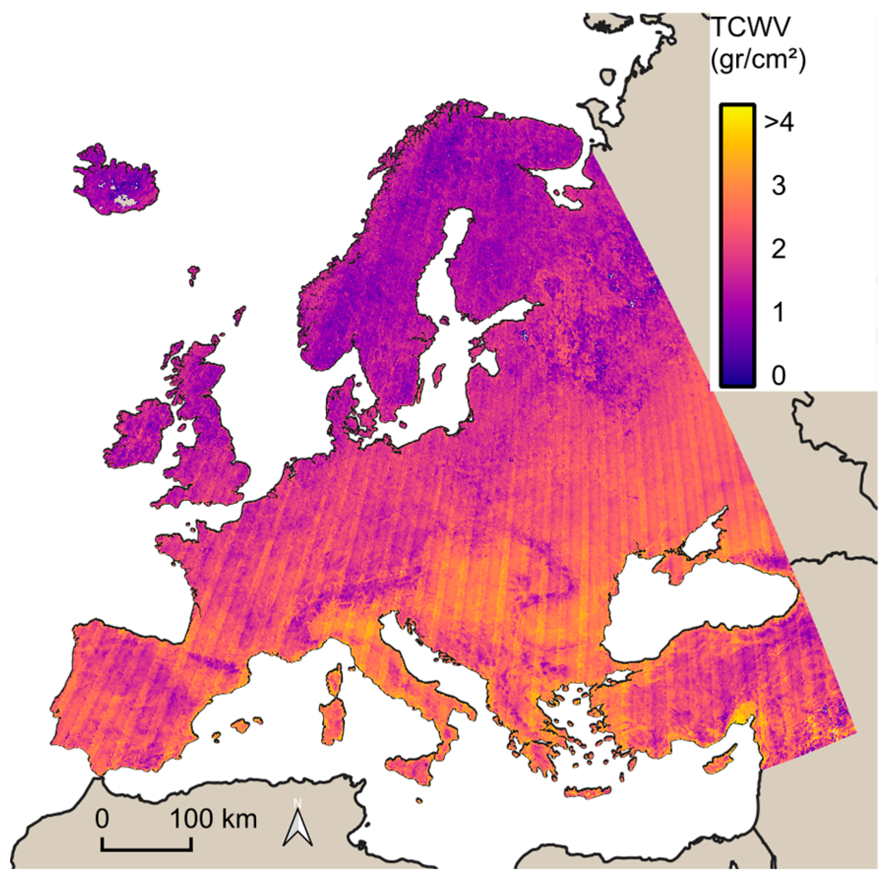
When stratifying stations by CORINE land cover and Köppen climate classification, only minimal differences in retrieval accuracy were observed. Slightly higher errors occurred over cropland areas (“non-irrigated arable land”) with a MAE of 0.73 g/cm2, and over grasslands, where a relatively high BIAS of 0.45 g/cm2 was observed. In contrast, a clear altitude-dependent bias was detected: low-altitude stations showed a tendency for negative bias (underestimation), while high-altitude stations showed positive bias (overestimation). Finally, the Landsat-based retrieval method was able to capture large-scale spatial patterns of water vapor distribution. As illustrated in Figure 3, the spatial distribution of mean summer TCWV for the 2013–2024 period demonstrates the method’s applicability for regional-scale climatological analyses.

4. Conclusions

Given its high variability, the global monitoring of water vapor demands observations at fine spatiotemporal resolution. In response to these needs, various methodologies and datasets have been developed in recent years. This study demonstrates, through a long-term and extensive validation, that a TIR-based approach using the MSWCVR algorithm provides a reliable means of retrieving TCWV at high spatial resolution. The method shows consistent accuracy across two ground-based datasets and multiple stations and is well suited for applications requiring fine-scale water vapor estimates. This approach offers a promising solution for enhancing LST retrievals, particularly in scenarios where operational LST products are unavailable, such as with recent missions like SDGSAT-1. As such, this TIR-based methodology represents a valuable addition to the Earth observation tools for atmospheric and surface monitoring [21].

Author Contributions

All authors designed the methodology. I.A. implemented the methodology and performed the statistical analysis; I.A., Y.B., C.C. and K.P. contributed to the analysis of the data, interpretation of the results, and the writing of the paper. All authors have read and agreed to the published version of the manuscript.

Funding

This research received no external funding.

Institutional Review Board Statement

Not applicable.

Informed Consent Statement

Not applicable.

Data Availability Statement

All data are available upon request.

Conflicts of Interest

The authors declare no conflicts of interest.

References

  1. Bojinski, S.; Verstraete, M.; Peterson, T.C.; Richter, C.; Simmons, A.; Zemp, M. The Concept of Essential Climate Variables in Support of Climate Research, Applications, and Policy. Bull. Am. Meteorol. Soc. 2014, 95, 1431–1443. [Google Scholar] [CrossRef]
  2. Sherwood, S.; Roca, R.; Weckwerth, T.; Andronova, N. Tropospheric Water Vapor, Convection, and Climate. Rev. Geophys. 2010, 48, RG2001. [Google Scholar] [CrossRef]
  3. Dessler, A.; Zhang, Z.; Yang, P. Water-Vapor Climate Feedback Inferred from Climate Fluctuations, 2003–2008. Geophys. Res. Lett. 2008, 35, L20704. [Google Scholar] [CrossRef]
  4. Li, Z.-L.; Tang, B.-H.; Wu, H.; Ren, H.; Yan, G.; Wan, Z.; Trigo, I.F.; Sobrino, J.A. Satellite-Derived Land Surface Temperature: Current Status and Perspectives. Remote Sens. Environ. 2013, 131, 14–37. [Google Scholar] [CrossRef]
  5. Hulley, G.; Ghent, D. Taking the Temperature of the Earth: Steps Towards Integrated Understanding of Variability and Change; Elsevier: Amsterdam, The Netherlands, 2019. [Google Scholar]
  6. Pérez-Ramírez, D.; Whiteman, D.N.; Smirnov, A.; Lyamani, H.; Holben, B.N.; Pinker, R.; Andrade, M.; Alados-Arboledas, L. Evaluation of AERONET Precipitable Water Vapor versus Microwave Radiometry, GPS, and Radiosondes at ARM Sites. J. Geophys. Res. Atmos. 2014, 119, 9596–9613. [Google Scholar] [CrossRef]
  7. Campanelli, M.; Mascitelli, A.; Sanò, P.; Diémoz, H.; Estellés, V.; Federico, S.; Iannarelli, A.M.; Fratarcangeli, F.; Mazzoni, A.; Realini, E.; et al. Precipitable Water Vapour Content from ESR/SKYNET Sun–Sky Radiometers: Validation against GNSS/GPS and AERONET over Three Different Sites in Europe. Atmos. Meas. Tech. 2018, 11, 81–94. [Google Scholar] [CrossRef]
  8. Yuan, P.; Blewitt, G.; Kreemer, C.; Hammond, W.C.; Argus, D.; Yin, X.; Van Malderen, R.; Mayer, M.; Jiang, W.; Awange, J.; et al. An Enhanced Integrated Water Vapour Dataset from More than 10 000 Global Ground-Based GPS Stations in 2020. Earth Syst. Sci. Data 2023, 15, 723–743. [Google Scholar] [CrossRef]
  9. Kursinski, E.; Hajj, G.; Schofield, J.; Linfield, R.; Hardy, K.R. Observing Earth’s Atmosphere with Radio Occultation Measurements Using the Global Positioning System. J. Geophys. Res. Atmos. 1997, 102, 23429–23465. [Google Scholar] [CrossRef]
  10. Smirnov, A.; Holben, B.; Lyapustin, A.; Slutsker, I.; Eck, T. AERONET Processing Algorithms Refinement. In Proceedings of the AERONET Workshop, El Arenosillo, Spain, 12–15 October 2004; pp. 10–14. [Google Scholar]
  11. Borger, C.; Beirle, S.; Wagner, T. A 16-Year Global Climate Data Record of Total Column Water Vapour Generated from OMI Observations in the Visible Blue Spectral Range. Earth Syst. Sci. Data 2023, 15, 3023–3049. [Google Scholar] [CrossRef]
  12. Grossi, M.; Valks, P.; Loyola, D.; Aberle, B.; Slijkhuis, S.; Wagner, T.; Beirle, S.; Lang, R. Total Column Water Vapour Measurements from GOME-2 MetOp-A and MetOp-B. Atmos. Meas. Tech. 2015, 8, 1111–1133. [Google Scholar] [CrossRef]
  13. Schneider, A.; Borsdorff, T.; Aemisegger, F.; Feist, D.G.; Kivi, R.; Hase, F.; Schneider, M.; Landgraf, J. First Data Set of H 2 O/HDO Columns from the Tropospheric Monitoring Instrument (TROPOMI). Atmos. Meas. Tech. 2020, 13, 85–100. [Google Scholar] [CrossRef]
  14. Ren, H.; Du, C.; Liu, R.; Qin, Q.; Yan, G.; Li, Z.-L.; Meng, J. Atmospheric Water Vapor Retrieval from Landsat 8 Thermal Infrared Images. J. Geophys. Res. Atmos. 2015, 120, 1723–1738. [Google Scholar] [CrossRef]
  15. Rosenkranz, P.W. Retrieval of Temperature and Moisture Profiles from AMSU-A and AMSU-B Measurements. IEEE Trans. Geosci. Remote Sens. 2002, 39, 2429–2435. [Google Scholar] [CrossRef]
  16. Sobrino, J.A.; Li, Z.-L.; Stoll, M.P.; Becker, F. Improvements in the Split-Window Technique for Land Surface Temperature Determination. IEEE Trans. Geosci. Remote Sens. 1994, 32, 243–253. [Google Scholar] [CrossRef]
  17. Li, Z.-L.; Jia, L.; Su, Z.; Wan, Z.; Zhang, R. A New Approach for Retrieving Precipitable Water from ATSR2 Split-Window Channel Data over Land Area. Int. J. Remote Sens. 2003, 24, 5095–5117. [Google Scholar] [CrossRef]
  18. Wang, M.; He, G.; Zhang, Z.; Wang, G.; Long, T. NDVI-Based Split-Window Algorithm for Precipitable Water Vapour Retrieval from Landsat-8 TIRS Data over Land Area. Remote Sens. Lett. 2015, 6, 904–913. [Google Scholar] [CrossRef]
  19. Wu, Y.; Jiang, N.; Xu, Y.; Yeh, T.-K.; Xu, T.; Wang, Y.; Su, W. Improving the Capability of Water Vapor Retrieval from Landsat 8 Using Ensemble Machine Learning. Int. J. Appl. Earth Obs. Geoinf. 2023, 122, 103407. [Google Scholar] [CrossRef]
  20. Gorelick, N.; Hancher, M.; Dixon, M.; Ilyushchenko, S.; Thau, D.; Moore, R. Google Earth Engine: Planetary-Scale Geospatial Analysis for Everyone. Remote Sens. Environ. 2017, 202, 18–27. [Google Scholar] [CrossRef]
  21. Philippopoulos, K.; Pantavou, K.; Cartalis, C.; Agathangelidis, I.; Mavrakou, T.; Polydoros, A.; Nikolopoulos, G. A Novel Artificial Neural Network Methodology to Produce High-Resolution Bioclimatic Maps Using Earth Observation Data: A Case Study for Cyprus. Sci. Total Environ. 2023, 893, 164734. [Google Scholar] [CrossRef] [PubMed]
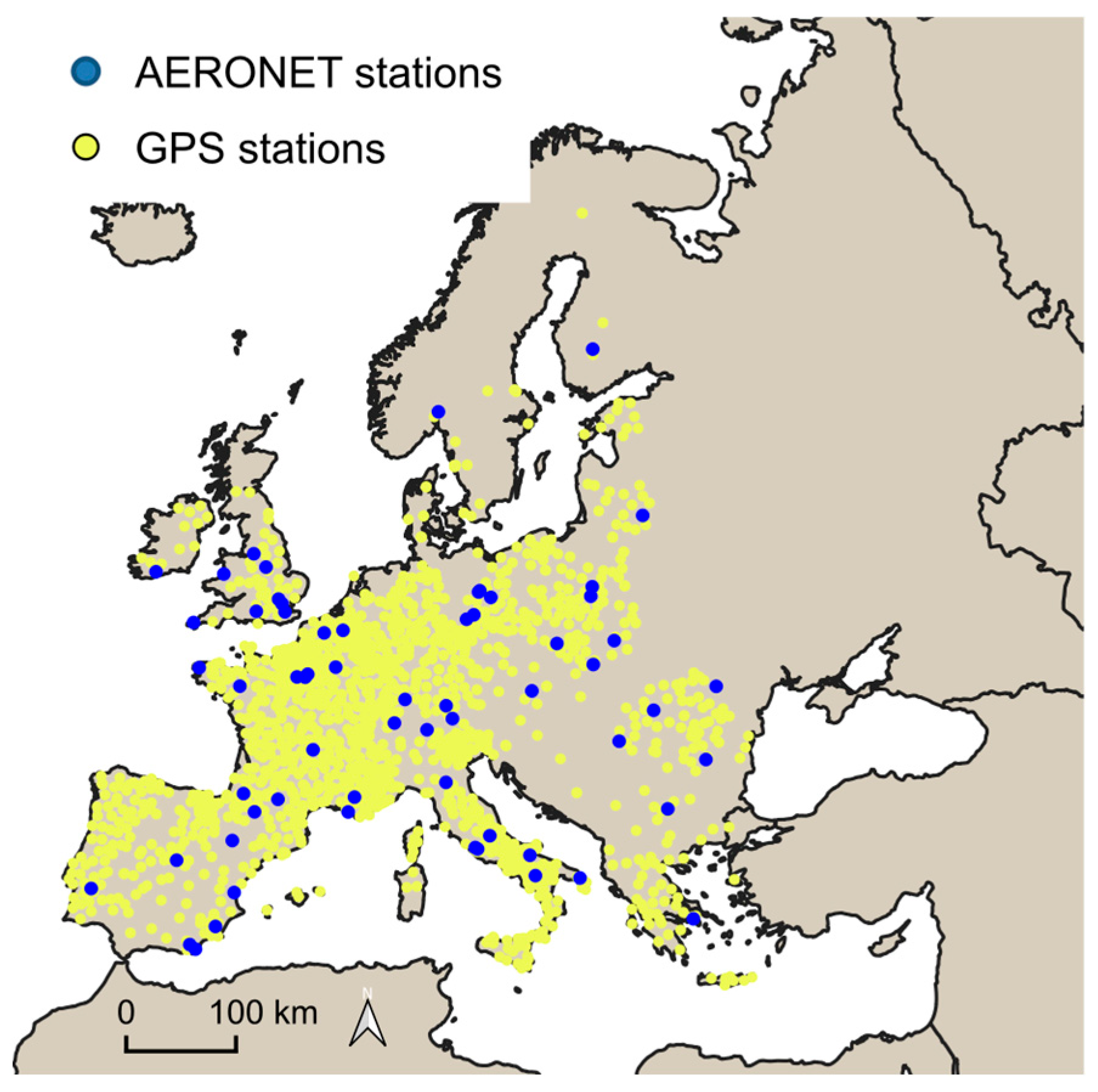
Figure 1. Study area, with spatial distribution of the ground-based stations.
Eesp 35 00006 g001
Figure 2. (a) Density scatter plot between Landsat 8/9 TCWV retrievals and AERONET observations and (b) distribution of TCWV differences between satellite and sun photometer estimates.
Eesp 35 00006 g002
Figure 3. Spatial distribution of mean summer TCWV (June–August) across Europe for the period 2013–2024, derived from Landsat 8 TIR-based retrievals.
Eesp 35 00006 g003
Table 1. Summary of validation metrics for the TIR-based TCWP retrieval against ground-based observations.
AERONET StationsGPS Stations
MAE (gr/cm2)0.600.59
RMSE (gr/cm2)0.770.79
BIAS (gr/cm2)0.150.13
r0.620.57
Disclaimer/Publisher’s Note: The statements, opinions and data contained in all publications are solely those of the individual author(s) and contributor(s) and not of MDPI and/or the editor(s). MDPI and/or the editor(s) disclaim responsibility for any injury to people or property resulting from any ideas, methods, instructions or products referred to in the content.