Proceeding Paper

Spatiotemporal Analysis of Forest Fires in Cyprus Using Earth Observation and Climate Data †

by
Maria Prodromou
1,2,*,‡,
Stella Girtsou
3,‡,
George Leventis
1,
Georgia Charalampous
1,
Alexis Apostolakis
2,3,
Marios Tzouvaras
1,2,
Christodoulos Mettas
1,2,
Giorgos Giannopoulos
3,
Charalampos Kontoes
3 and
Diofantos Hadjimitsis
1,2
1
ERATOSTHENES Centre of Excellence, Limassol 3012, Cyprus
2
Department of Civil Engineering and Geomatics, Cyprus University of Technology, Limassol 3036, Cyprus
3
National Observatory of Athens, Operational Unit BEYOND Centre for Earth Observation Research and Satellite Remote Sensing IAASARS/NOA, GR-152 36 Athens, Greece
*
Author to whom correspondence should be addressed.
Presented at the 17th International Conference on Meteorology, Climatology, and Atmospheric Physics—COMECAP 2025, Nicosia, Cyprus, 29 September–1 October 2025.
These authors contributed equally to this work.
Environ. Earth Sci. Proc. 2025, 35(1), 54; https://doi.org/10.3390/eesp2025035054
Published: 29 September 2025

Abstract

Wildfire detection remains a critical challenge for authorities, with human activity being the leading cause. The historical conditions prevailing in burned forest areas require a comprehensive analysis at both the environmental and anthropogenic levels. This study presents a multidimensional dataset comprising data from 2008 to 2024 and integrating Earth observation data and anthropogenic, environmental, meteorological, topographic, and fire-related features. This study evaluates, through time series analysis, the impact of climate trends such as increased temperature in comparison with anthropogenic activities such as deliberate fires. Time series analysis reveals that although climatic conditions with increased temperature and reduced precipitation in Cyprus intensify the risk of fire, the presence of fire events is primarily due to deliberate actions. The findings of this study support national-scale fire modeling, offering a foundation for targeted prevention, early warning systems, and sustainable forest fire management strategies.

1. Introduction

Wildfires are a persistent and escalating threat in all ecosystems but are particularly characteristic of the Mediterranean region [1]. Extreme weather conditions characterized by increasing heatwaves combined with drought and land-use change are expected to lead to highly flammable environments, leading to higher fire risk, longer fire seasons, and more frequent large and severe fires [2,3,4]. Additionally, the impact of wildfires on society has increased due to factors like urban expansion [5] into fire-prone zones, human-caused fires in unadapted ecosystems, and the accumulation of combustible material (fuel), which can lead to uncontrollable mega-fires [6,7]. It is worth mentioning that these fires result from fuel accumulation during the wet season and increased drought during the dry summer season.
Time series analysis has historically served as a fundamental element that provides scholars with a means to scrutinize patterns and developments evident in longitudinal data. Such methodology proves indispensable in deciphering fluctuations across seasons, extended alterations, and prospective trajectories [8]. The efficacy of machine learning is significantly enhanced through its application to multimodal datasets that fuse data from various sources and types. Such datasets facilitate a more holistic understanding of complex systems through the integration of disparate information, including satellite imagery, ground-based measurements, and socio-economic data [9].
The integration of time series analysis, spatiotemporal methods, machine learning, and multimodal datasets has significantly advanced environmental research, particularly in wildfire risk prediction and management. These combined approaches offer powerful tools for understanding complex dynamics and improving forecasting accuracy [10,11,12,13] supporting more informed decision-making in wildfire mitigation and broader environmental challenges.
Evaluating the integrated spatiotemporal patterns of natural hazardous events is crucial for effective disaster risk management [12,13,14,15]. This study aims to conduct a comprehensive spatiotemporal analysis of forest fires in Cyprus, located in the Eastern Mediterranean region, utilizing a multimodal dataset. It specifically seeks to understand the environmental conditions, such as temperature, humidity, and wind speed, that contributed to the occurrence of fire events during the period from 2008 to 2024 in order to provide data-driven insights that support fire prevention strategies. For the purposes of this study, the methodology is divided into two main parts: the first focuses on developing the multimodal dataset, and the second on spatiotemporal analysis.
Regarding the spatiotemporal analysis of fires occurrences similar studies were conducted in several parts of the world like Australia [16], Brazilian Amazon [17], Spain [18], Portugal [14], Southern Africa [19], Africa and Madagascar [20] and Mediterranean Basis [21].

2. Methodology

2.1. Study Area

Cyprus is located at the northeastern end of the Mediterranean basin, covering an area of 9251 Km2. The island features a predominantly mountainous terrain and a distinctly Mediterranean climate, characterized by dry and hot summers that typically extend from May to October. During the fire season, temperatures range from 30 °C to 40 °C, increasing the risk of ignition. Relative humidity also plays a crucial role in the fire dynamics, varying from 30% to 65%. Precipitation during this period is very low, generally ranging between 0 and 50 mm. Wind is another significant factor; during the fire season, it is generally northwesterly or northerly. Wind greatly impacts fire behavior and poses challenges to prediction due to its variability in speed and direction, along with the influences from topography, vegetation, and local conditions [22,23,24,25].
Based on the records provided by the Department of Forests in Cyprus from 2000 to 2023 (Figure 1), forest fires (of which 37.2% attributed to human activities) in Cyprus destroyed over 55,240 ha of burnt areas, including state forests and surrounding areas [26].

2.2. Data and Methods

Data Processing

This study focuses on the spatiotemporal analysis of peak fire occurrence during summer periods (June–August). The analysis was conducted over a 17-year period, from 2008 to 2024, using a multimodal EO dataset. Specifically, data from various sources were used to create the multidimensional dataset for the analysis of fires in Cyprus based on the approach conducted by Prodromou et al., 2024 [27]. Table 1 summarizes all the data collected from the respective sources, including some information on their spatial and temporal analysis.
Time series analysis was applied to the abovementioned environmental variables in order to investigate the seasonal dynamics in Cyprus, followed by correlation analysis using the Pearson correlation coefficient that was employed to examine the relationships between fire occurrence and its potential drivers. This integrated approach supports a comprehensive understanding of the spatiotemporal variability and underlying drivers of wildfire activity.
Also, the Random Forest classifier was implemented for this study to predict the fire risk. Prior to implementing the algorithm, some pre-processed actions were applied to the dataset to address missing values (NaN) and normalize features to a common scale to ensure consistent performance across different data types. Hyperparameter tuning was conducted using the RandomizedSearchCV approach, and model robustness was ensured through GroupKFold cross-validation. Various metrics, including precision, recall, F1-score, and AUC, were employed to assess model accuracy during tuning.

3. Results and Discussion

Based on the analysis of the annual variation in fire frequency in the Cyprus region during the summer months from 2008 to 2024, the results present a moderate increasing trend, as shown in Figure 2, with an average annual increase of 8.5 hectares. However, the low R2 (0.12) indicates high interannual variability, suggesting that fire activity is driven by complex, non-linear environmental and anthropogenic factors.
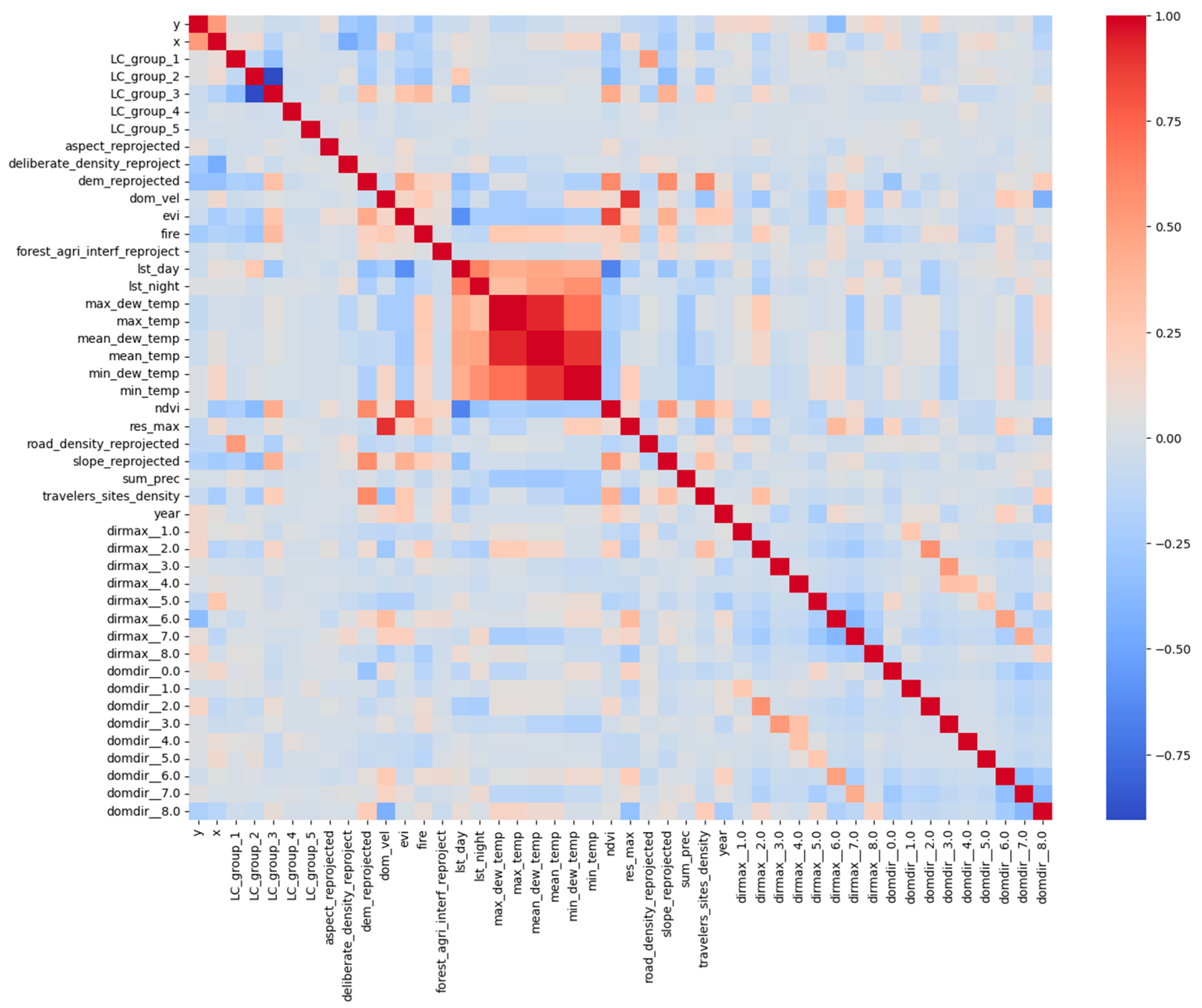
Based on the Pearson correlation (Figure 3), a strong positive relationship was indicated between temperature-related variables (e.g., max, mean, and dew point temperatures), indicating their independence. In addition to that, vegetation indices (EVI and NDVI) also showed strong correlation, reflecting consistent vegetation dynamics. Fire occurrence shows weak to moderate positive correlations with variables such as maximum temperature and NDVI and negative correlations with precipitation and nighttime land surface temperature. These results underscore the importance of investigating various fire-related variables to comprehend fire dynamics.
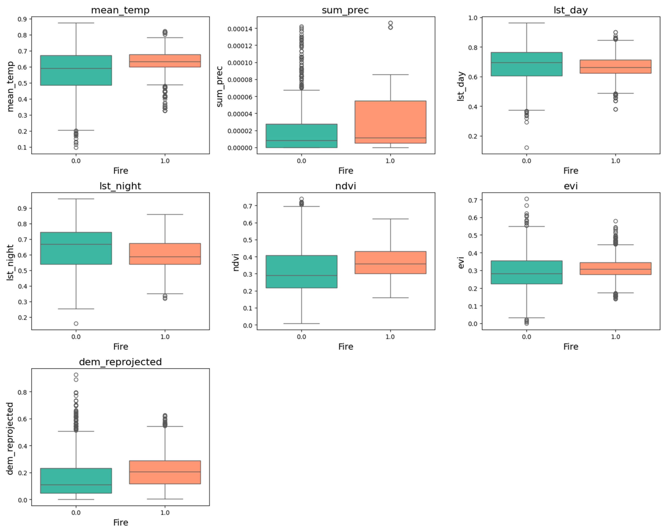
Subsequently, boxplot analysis explored the distribution of the values for key environmental variables in cases of fire occurrence and non-fire occurrence as presented in Figure 4. The outcomes revealed that areas affected by fire consistently exhibited higher values of temperature-related variables, including mean air temperature, daytime land surface temperature, and nighttime temperature, compared to non-fire areas. These findings underline the role of heat stress in promoting fire occurrence. In addition, fire-prone areas showed slightly higher vegetation indices (NDVI, EVI), suggesting that greater vegetation biomass may contribute to higher fuel availability. Notably, total precipitation values were low in both fire and non-fire areas; however, fire-affected zones exhibited slightly lower median values and a narrower range, indicating consistently drier conditions that may contribute to fire ignition and spread. The topographic characteristics, i.e., elevation showed moderate differences, where fire events were observed more frequently at lower altitudes. These patterns highlight the correlation between climatic stressors, vegetation structure, and terrain in shaping wildfire susceptibility.
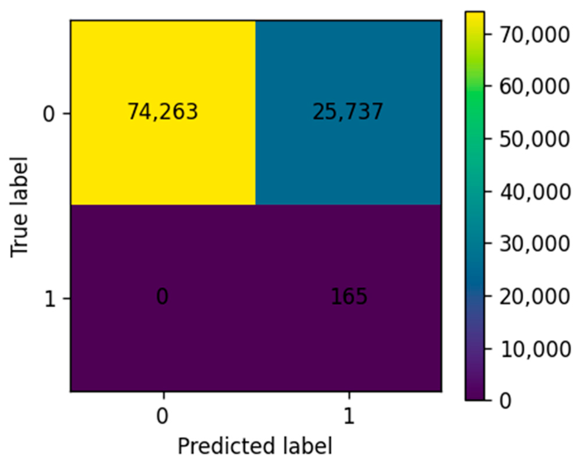
Furthermore, a machine learning-based fire risk prediction model was developed using the built multimodal dataset. Among the tested classifiers, the Random Forest algorithm exhibited strong predictive capabilities, especially when evaluated against a GroupKFold cross-validation approach. Following hyperparameter optimization using RandomizedSearchCV, the Random Forest classifier achieved a recall of 100% for fire events and 74% for no-fire instances on the test set, demonstrating its suitability for operational use as presented in Figure 5.

4. Conclusions

This study presents a comprehensive approach to the spatiotemporal analysis of wildfire risk in Cyprus by integrating environmental, climatic, and anthropogenic variables into a harmonized multimodal dataset. Based on the findings derived from the spatiotemporal analysis, the climatic variables like high temperature and low precipitation lead to the increase of fire susceptibility, but in our case, human activities and especially deliberate fires correspond to the main ignition cause. Moreover, the time series analysis from 2008 to 2024 indicated that precipitation showed a stronger inverse relationship with burned areas than temperature, highlighting the importance of dry conditions. Regarding the machine learning algorithm, the Random Forest classifier trained on this dataset achieved 100% recall for fire events, demonstrating high potential for operational fire prediction. These findings support the use of AI and multimodal data fusion for developing early warning systems and future digital twin models to enhance wildfire management in the Eastern Mediterranean. Our future work will focus on a comparative analysis of machine learning and deep learning algorithms to enhance fire risk prediction capabilities in Cyprus.

Author Contributions

Conceptualization, S.G. and M.P.; methodology, M.P. and S.G.; software, M.P. and S.G.; validation, M.P. and S.G.; formal analysis, M.P. and S.G., investigation, M.P. and S.G.; resources, M.P. and S.G.; data curation, M.P. and S.G.; writing—original draft preparation, M.P., S.G., G.L., G.C., A.A., M.T., C.M., G.G. and C.K.; writing—review and editing, M.P., S.G., G.L., G.C., A.A., M.T., C.M., G.G. and C.K.; visualization, M.P. and S.G.; supervision, D.H.; project administration, D.H.; funding acquisition, D.H. All authors have read and agreed to the published version of the manuscript.

Funding

This work was funded through the EXCELSIOR Teaming project (Grant Agreement No. 857510, www.excelsior2020.eu, accessed on 22 January 2025), which has received funding from the European Union’s Horizon 2020 research and innovation programme. Funding was also received from the Government of the Republic of Cyprus through the Directorate General for the European Programmes, Coordination and Development, as well as the Cyprus University of Technology.

Institutional Review Board Statement

Not applicable.

Informed Consent Statement

Not applicable.

Data Availability Statement

Data are contained within the article.

Acknowledgments

The authors acknowledge the ‘EXCELSIOR’: ERATOSTHENES: Excellence Research Centre for Earth Surveillance and Space-Based Monitoring of the Environment H2020 Widespread Teaming project (www.excelsior2020.eu, accessed on 22 January 2025). The ‘EXCELSIOR’ project has received funding from the European Union’s Horizon 2020 research and innovation programme under Grant Agreement No 857510, from the Government of the Republic of Cyprus through the Directorate General forthe European Programmes, Coordination and Development, and from the Cyprus University of Technology. The authors also acknowledge AI-OBSERVER Twinning project (https://ai-observer.eu/, accessed on 22 January 2025) titled “Enhancing Earth Observation capabilities of the Eratosthenes Centre of Excellence on Disaster Risk Reduction through Artificial Intelligence” that is funded by the European Union with Grant Agreement No. 101079468.

Conflicts of Interest

The authors declare no conflicts of interest.

References

  1. Francos, M.; Colino-Prieto, F.; Sánchez-García, C. How Mediterranean Ecosystem Deals with Wildfire Impact on Soil Ecosystem Services and Functions: A Review. Land 2024, 13, 407. [Google Scholar] [CrossRef]
  2. Duguy, B.; Paula, S.; Pausas, J.G.; Alloza, J.A.; Gimeno, T.; Vallejo, R.V. Effects of Climate and Extreme Events on Wildfire Regime and Their Ecological Impacts. In Regional Assessment of Climate Change in the Mediterranean: Volume 2: Agriculture, Forests and Ecosystem Services and People; Springer: Dordrecht, The Netherlands, 2013; pp. 101–134. [Google Scholar]
  3. Ruffault, J.; Moron, V.; Trigo, R.M.; Curt, T. Objective Identification of Multiple Large Fire Climatologies: An Application to a Mediterranean Ecosystem. Environ. Res. Lett. 2016, 11, 075006. [Google Scholar] [CrossRef]
  4. Turco, M.; Llasat, M.-C.; von Hardenberg, J.; Provenzale, A. Climate Change Impacts on Wildfires in a Mediterranean Environment. Clim. Change 2014, 125, 369–380. [Google Scholar] [CrossRef]
  5. Radeloff, V.C.; Helmers, D.P.; Kramer, H.A.; Mockrin, M.H.; Alexandre, P.M.; Bar-Massada, A.; Butsic, V.; Hawbaker, T.J.; Martinuzzi, S.; Syphard, A.D.; et al. Rapid Growth of the US Wildland-Urban Interface Raises Wildfire Risk. Proc. Natl. Acad. Sci. USA 2018, 115, 3314–3319. [Google Scholar] [CrossRef]
  6. Carmenta, R.; Cammelli, F.; Dressler, W.; Verbicaro, C.; Zaehringer, J.G. Between a Rock and a Hard Place: The Burdens of Uncontrolled Fire for Smallholders across the Tropics. World Dev. 2021, 145, 105521. [Google Scholar] [CrossRef]
  7. Schweizer, D.; Nichols, T.; Cisneros, R.; Navarro, K.; Procter, T. Wildland Fire, Extreme Weather and Society: Implications of a History of Fire Suppression in California, USA. In Extreme Weather Events and Human Health; Springer International Publishing: Cham, Switzerland, 2020; pp. 41–57. [Google Scholar]
  8. Geurts, M.; Box, G.E.P.; Jenkins, G.M. Time Series Analysis: Forecasting and Control. J. Mark. Res. 1977, 14, 269. [Google Scholar] [CrossRef]
  9. Lahat, D.; Adali, T.; Jutten, C. Multimodal Data Fusion: An Overview of Methods, Challenges, and Prospects. Proc. IEEE 2015, 103, 1449–1477. [Google Scholar] [CrossRef]
  10. Cheng, T.; Wang, J.; Haworth, J.; Heydecker, B.; Chow, A. A Dynamic Spatial Weight Matrix and Localized Space–Time Autoregressive Integrated Moving Average for Network Modeling. Geogr. Anal. 2014, 46, 75–97. [Google Scholar] [CrossRef]
  11. Prodromou, M.; Theocharidis, C.; Gitas, I.Z.; Eliades, F.; Themistocleous, K.; Papasavvas, K.; Dimitrakopoulos, C.; Danezis, C.; Hadjimitsis, D. Forest Habitat Mapping in Natura2000 Regions in Cyprus Using Sentinel-1, Sentinel-2 and Topographical Features. Remote Sens. 2024, 16, 1373. [Google Scholar] [CrossRef]
  12. Apostolakis, A.; Girtsou, S.; Giannopoulos, G.; Bartsotas, N.S.; Kontoes, C. Estimating Next Day’s Forest Fire Risk via a Complete Machine Learning Methodology. Remote Sens. 2022, 14, 1222. [Google Scholar] [CrossRef]
  13. Girtsou, S.; Apostolakis, A.; Giannopoulos, G.; Kontoes, C. A Machine Learning Methodology for Next Day Wildfire Prediction. In Proceedings of the 2021 IEEE International Geoscience and Remote Sensing Symposium (IGARSS), Brussels, Belgium, 11–16 July 2021; pp. 8487–8490. [Google Scholar]
  14. Tonini, M.; Pereira, M.G.; Parente, J.; Vega Orozco, C. Evolution of Forest Fires in Portugal: From Spatio-Temporal Point Events to Smoothed Density Maps. Nat. Hazards 2017, 85, 1489–1510. [Google Scholar] [CrossRef]
  15. Prodromou, M.; Girtsou, S.; Leventis, G.; Koumoulidis, D.; Tzouvaras, M.; Mettas, C.; Apostolakis, A.; Kaskara, M.; Kontoes, H.; Hadjimitsis, D. Creation of Data Cube for the Analysis of Wildfires in Cyprus Using Open Access Data. In Proceedings of the European Geosciences Union General Assembly 2024 (EGU24), Vienna, Austria, 14–19 April 2024. [Google Scholar]
  16. Valente, F.; Laurini, M. Spatio-Temporal Analysis of Fire Occurrence in Australia. Stoch. Environ. Res. Risk Assess. 2021, 35, 1759–1770. [Google Scholar] [CrossRef]
  17. Valente, F.; Laurini, M. A Spatio-Temporal Analysis of Fire Occurrence Patterns in the Brazilian Amazon. Sci. Rep. 2023, 13, 12727. [Google Scholar] [CrossRef]
  18. Rodrigues, M.; Jiménez, A.; de la Riva, J. Analysis of Recent Spatial–Temporal Evolution of Human Driving Factors of Wildfires in Spain. Nat. Hazards 2016, 84, 2049–2070. [Google Scholar] [CrossRef]
  19. Strydom, S.; Savage, M.J. A Spatio-Temporal Analysis of Fires in the Southern African Development Community Region. Nat. Hazards 2018, 92, 1617–1632. [Google Scholar] [CrossRef]
  20. Wan, C.; Roy, S. Sen Geospatial Characteristics of Fire Occurrences in Southern Hemispheric Africa and Madagascar during 2001–2020. J. For. Res. 2023, 34, 553–563. [Google Scholar] [CrossRef]
  21. de Rivera, Ó.R.; Espinosa, J.; Madrigal, J.; Blangiardo, M.; López-Quílez, A. Spatio-Temporal Marked Point Process Model to Understand Forest Fires in the Mediterranean Basin. J. Agric. Biol. Environ. Stat. 2025, 30, 700–729. [Google Scholar] [CrossRef]
  22. Prodromou, M.; Gitas, I.; Mettas, C.; Tzouvaras, M.; Danezis, C.; Hadjimitsis, D. Comparative Analysis of Supervised Machine Learning Algorithms for Forest Habitat Mapping in Cyprus. Sustainability 2025, 17, 6021. [Google Scholar] [CrossRef]
  23. Prodromou, M.; Gitas, I.; Mettas, C.; Tzouvaras, M.; Themistocleous, K.; Konstantinidis, A.; Pamboris, A.; Hadjimitsis, D. Remote-Sensing-Based Prioritization of Post-Fire Restoration Actions in Mediterranean Ecosystems: A Case Study in Cyprus. Remote Sens. 2025, 17, 1269. [Google Scholar] [CrossRef]
  24. Petrou, P.; Stampoulidis, A.; Pipinis, E.; Kitikidou, K.; Milios, E. Analysis of the Environments Where Natural Regeneration Is Established in the Absence of a Wildfire in the Open Pinus Brutia Forests in the Middle Elevations of the Central Part of Cyprus. Forests 2024, 15, 1228. [Google Scholar] [CrossRef]
  25. Petrou, P.; Milios, E. Investigation of the Factors Affecting Artificial Seed Sowing Success and Seedling Survival in Pinus Brutia Natural Stands in Middle Elevations of Central Cyprus. Forests 2020, 11, 1349. [Google Scholar] [CrossRef]
  26. Department of Forests in Cyprus. Forest Fire Statistics for the Period 2000-2023; Department of Forests in Cyprus: Lefkosia, Cyprus, 2023. [Google Scholar]
  27. Prodromou, M.; Girtsou, S.; Leventis, G.; Koumoulidis, D.; Tzouvaras, M.; Mettas, C.; Apostolakis, A.; Kaskara, M.; Kontoes, H.; Hadjimitsis, D. Multimodal Dataset for Wildfire Risk Prediction in Cyprus. In Proceedings of the IGARSS 2024—2024 IEEE International Geoscience and Remote Sensing Symposium, Athens, Greece, 7–12 July 2024; pp. 3332–3336. [Google Scholar]
Figure 1. Forest fires in Cyprus from 2000 to 2023, based on the statistics provided by the Department of Forests in Cyprus.
Eesp 35 00054 g001
Figure 2. Linear trend analysis for total burned area per year.
Eesp 35 00054 g002
Figure 3. Pearson correlation matrix of the variables included in the multimodal dataset.
Eesp 35 00054 g003
Figure 4. Boxplots comparing the distribution of key environmental variables between fire-affected (fire = 1) and non-fire (fire = 0) locations.
Eesp 35 00054 g004
Figure 5. Confusion matrix for the Random Forest classifier.
Eesp 35 00054 g005
Table 1. Overview of the data sources, spatial and temporal resolution, and variables used for fire occurrence analysis.
SourceFeatureSpatial
Resolution
Temporal
Resolution
MODISLand Surface Temperature
(MYD11A2 and MOD11A2)
1 km8 days
NDVI, EVI (MYD13A1 and MOD13A1)500 m16 days
ERA 5—reanalysis2 m temperature, 2 m dewpoint temperature, and Total Precipitation9 kmhourly
10 m U and V wind
component
Wind speed and direction
(dirmax, domra)
Land—CopernicusCorine Land Cover2012, 2018100 m
Digital Elevation Model (DEM) (slope, elevation, aspect) 25 m
EFFISFire historydaily
2009–2022
20–250 m
Datagov.cyAnthropogenic factors—
Picnic, camping areas, and deliberate fires
Static-
Disclaimer/Publisher’s Note: The statements, opinions and data contained in all publications are solely those of the individual author(s) and contributor(s) and not of MDPI and/or the editor(s). MDPI and/or the editor(s) disclaim responsibility for any injury to people or property resulting from any ideas, methods, instructions or products referred to in the content.