Proceeding Paper

Precipitation Nowcasting with Weather Radar and Lightning Data Assimilation †

by
John Kalogiros
*,
Panagiotis Portalakis
,
Nikolaos Roukounakis
,
Dimitrios Katsanos
and
Adrianos Retalis
Institute for Environmental Research and Sustainable Development, National Observatory of Athens, 15236 Athens, Greece
*
Author to whom correspondence should be addressed.
Presented at the 17th International Conference on Meteorology, Climatology, and Atmospheric Physics—COMECAP 2025, Nicosia, Cyprus, 29 September–1 October 2025.
Environ. Earth Sci. Proc. 2025, 35(1), 50; https://doi.org/10.3390/eesp2025035050
Published: 26 September 2025

Abstract

Assimilation of weather radar data, as well as additional data like lightning data, in high-resolution weather forecast models is a promising method to improve short-term forecasting (nowcasting) of flash-flood events. A data assimilation system based on the Weather Research and Forecasting model is used in this study, with radar reflectivity and radial velocity data collected with X-band Doppler polarimetric radar in the area of Athens, Greece, and lightning observations obtained from a lightning detection network covering Greece. Radar data are assimilated with the four-dimensional variational method, which includes a full-hydrometeor assimilation scheme, in a nested domain of the model with a resolution of 3 km. Humidity, vertical velocity and horizontal wind divergence profiles estimated from lightning data are assimilated with a three-dimensional variation method in the parent domain of the model with a resolution of 9 km. The results from a case study are presented to show the effect of assimilating each type of data.

1. Introduction

Forecasting precipitation in the coastal area of the Mediterranean region is a significant challenge due to the complex terrain and its effect on rainfall. Climate change has led to an increase in severe weather and subsequent flash-flood events in this region. Early warning systems with high accuracy are necessary for better preparedness and responses in order to mitigate the impact of these events. Weather observations and forecasting are essential parts of such systems.
The Weather Research and Forecasting (WRF) model is a widely used mesoscale model for research and operational purposes with an advanced data assimilation (DA) system, which includes the three (3D-Var)- and four-dimensional (4D-Var) variational methods [1]. The system can assimilate weather radar and lightning data with various options. The 4D-Var method is a temporal extension of 3D-Var, and it has been found to improve the short-term forecasting (nowcasting) of intense precipitation with the assimilation of weather radar data [1,2], but it requires large amounts of computational resources. However, there are techniques to speed up this method [3]. WRF-DA assimilates radar reflectivity and radial velocity data with various schemes. A recently developed full-hydrometeor assimilation scheme integrates warm-rain and cold-cloud processes without the need to indirectly partition radar reflectivity to hydrometeor types [4]. Lightning observations, which are assimilated indirectly with the 3D-Var method, may improve forecasts during convective storms, especially in areas not covered by weather radars. Thunderstorm cells are characterized by high humidity and wind convergence (i.e., air vertical velocity) values, and thus, methods which assimilate these parameters should be more effective [5].
In this work, a radar and lightning data assimilation system based on WRF-DA is presented and evaluated for a precipitation event in the region of Athens, Greece. Section 2 presents the data and methodology used in this study, Section 3 presents the results from the case study, and our conclusions are summarized in Section 4.

2. Data and Methodology

Reflectivity and radial velocity data were collected with the mobile X-band Doppler polarimetric radar (XPOL) of the National Observatory of Athens (NOA), which typically operates on top of a 500 m hill in the suburbs of Athens, Greece, with a gate resolution of 300 m and a range of 120 km. The time taken to complete a volume scan is about 2 min. The volume scan includes plan position indicator (PPI) scans at 1°, 2° and 3° antenna elevations for measurement of the spatial distribution of precipitation, and Range Height Indicator (RHI) vertical section scans at selected azimuth angles for measurement of the vertical structure of precipitation. The radar data were processed with dual-polarization algorithms developed in [6], which include the attenuation and vertical profile of reflectivity corrections. An elevation-hybrid scan of near-surface rainfall was estimated using measurement sectors with minimal beam blockage by the terrain. Lightning observations were collected with a lightning detection network consisting of six low-cost VLF-LF frequency receivers operating in Greece. The estimation of lightning position was based on the time and direction of its arrival [7]. The number density of lightning observations in 10 min periods and 9 km cells was converted to proxy air humidity and vertical velocity-divergence profiles, similarly to [5].
The WRF model (version 4.6.1) setup included three nested domains at 9, 3 and 1 km (for high-resolution forecasting in the Athens area) spatial resolutions, as shown in Figure 1. Two-way nesting, high resolution (about 30 m) terrain and the Lin cloud microphysics scheme [8] were used. The initial and boundary conditions at a spatial resolution of 7 km at the start of the assimilation period were provided by the Icosahedral Nonhydrostatic (ICON) weather forecast model, which is available in real time from the German Weather Service (DWD). Data assimilation was performed in a time period of three successive cycles of 10 min each just before the analysis time, in order to reduce the effects of the linear model approximation used in the 4D-Var minimization of the cost function. The control variables in 4D-Var include wind, air vertical velocity, pressure, temperature, and the relative humidity and specific humidity of hydrometeors. The background error covariances were previously estimated per season using the NMC method [9] for 3 h forecasts every 2 h instead of the usual 24 h forecasts every 12 h for all events recorded in the last four years. The scaling parameters for the WRF-DA of background error covariances have a significant effect on the assimilation results [10]. In this study, their values were qualitatively selected to achieve results closer to the radar observations. More specifically, the length scaling was set to 0.5 (less spatial spread of the influence of observations), except for the case of the wind components in radar data assimilation, where it was set to 2.0 (more spatial spread of the influence of observations). The assimilation of 3D-Var lightning data followed by 4D-Var radar data in each 10 min time period took place in the first and second domains, respectively. No-echo radar data assimilation was used to remove precipitation where it was not observed. After each 10 min assimilation, the new initial conditions are interpolated down to the finer resolution domains, and a short 20 min WRF forecast was conducted for the calculation of the initial conditions of the next 10 min period. Finally, a three-hour forecast is conducted with the new initial conditions at the analysis time.

3. Results

The precipitation event of 5 October 2024 is analyzed in this section. South-westerly winds were transporting moist, unstable air and thunderstorm cells in the region of most interest (second domain). Figure 2 and Figure 3 show the radar observations of rainfall and lightning estimated locations, respectively, in time periods just before and after the analysis time (11:00 UTC).
The results from the WRF forecast based on ICON initialization data without any data assimilation are shown in Figure 4. The forecast was initialized at 10:00 UTC to allow for a warming (spin-up) period of one hour. A limited amount of rainfall was forecasted in this time period in the second domain of the simulation.
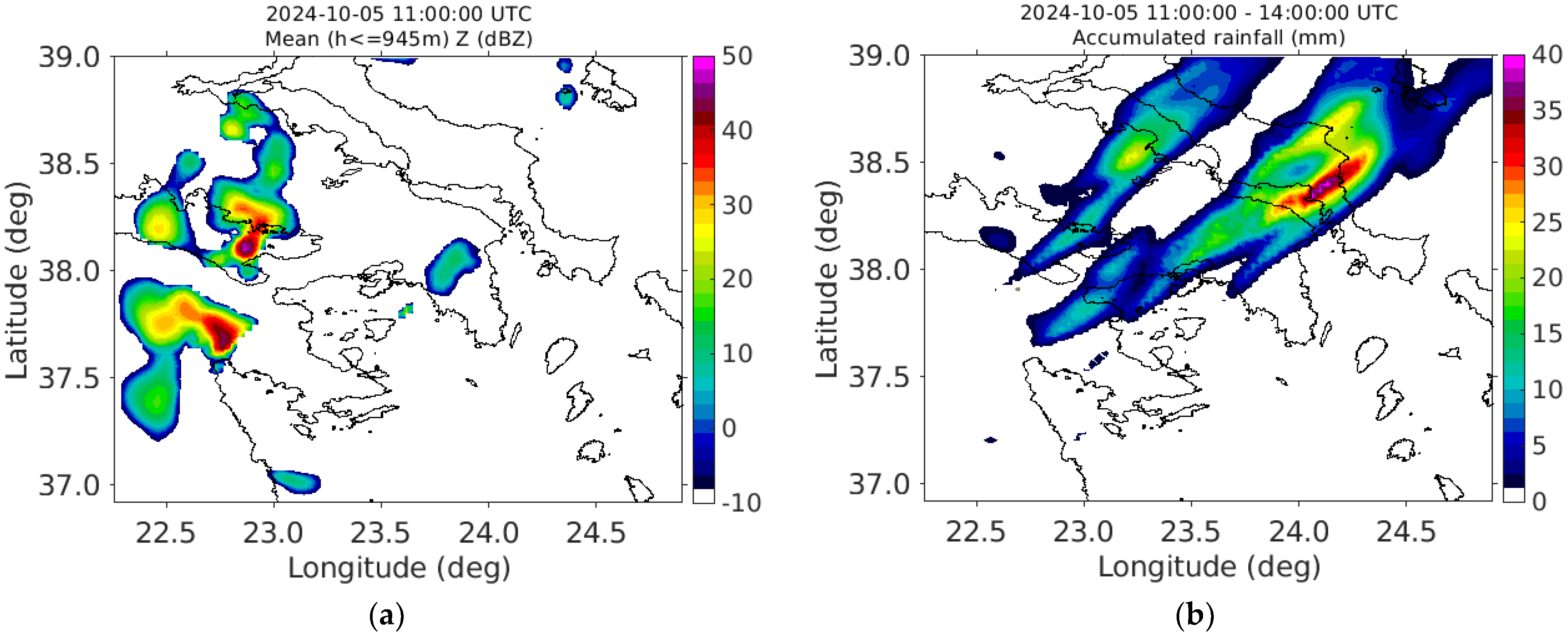
Figure 5 shows the results from the assimilation of only radar data in the second domain and within the sector of radar measurements. As mentioned above, the assimilation period started at 10:30 UTC with initialization data from ICON at 10:00 UTC and a WRF forecast until 10:30 UTC. Data assimilation added hydrometeors, i.e., increased the calculated radar reflectivity, in the echo areas of the radar measurements. Also, it removed hydrometeors in the echo cells of the model (Figure 4a) inside the radar measurement sector that did not contain radar echo (Figure 5a). With radar data assimilation, rainfall bands were created in the model in the same direction as observed in the radar measurements (Figure 2). The intense storm activity in the center of Evia island to the northeast of Athens (Figure 3b) was also forecasted. However, limited rainfall was accumulated in the southwestern part of the second domain, where thunderstorm cells were advected from outside the second domain.
Figure 6 shows the results with radar and lightning data assimilation. The lightning data assimilation took place in the first domain, but it was interpolated down to the second domain, as mentioned previously. The lightning cells observed in the southwest part of the domain (Figure 3) added hydrometers and wind convergence zones in this area, which were then advected by the model towards the northeast direction. Thus, additional bands of accumulated rain were forecasted, similar to the radar observations in the time period of the forecast (Figure 2).

4. Discussion and Conclusions

The results of the combined radar–lightning data assimilation showed a significant and promising improvement in precipitation nowcasting. The 4D-Var assimilation scheme of radar data in a 30 min time period also works as a spin-up period for the model. The lightning data provided the required missing information outside the measurement area of the radar, which complements the radar information for thunderstorm advection from this area. This assimilation and nowcasting system is currently running in operational mode on a simple 18-core personal computer (1.5 h is needed to complete the nowcast), while raw radar and lightning data are processed on a second computer with less computational power. Future work will include real-time assimilation of additional data, like Global Navigation Satellite System (GNSS) zenith tropospheric delay observations at a large number of stations in Greece, to add more information in the first domain. The proposed system could form the basis of a local operational early warning system for flash-floods that requires relatively limited computer resources.

Author Contributions

Conceptualization, J.K.; data curation, J.K., P.P., N.R. and D.K.; writing—original draft preparation, J.K.; writing—review and editing, J.K., P.P., N.R., D.K. and A.R. All authors have read and agreed to the published version of the manuscript.

Funding

This research received no external funding.

Data Availability Statement

The data presented in this study are available on request from the corresponding author.

Acknowledgments

This study was conducted using the open-source (https://github.com/wrf-model/WRF, accessed on 22 September 2025) Weather Research and Forecasting (WRF) model version 4.6.1, developed by the National Center for Atmospheric Research, USA. Initialization forecast data of the Icosahedral Nonhydrostatic (ICON) model were accessed with the open data service (https://opendata.dwd.de/weather/nwp/icon-eu/grib/, accessed on 22 September 2025) of the German Meteorological Service (DWD).

Conflicts of Interest

The authors declare no conflicts of interest.

References

  1. Wang, H.; Sun, J.; Zhang, X.; Huang, X.; Auligne, T. Radar data assimilation with WRF 4D-Var. Part I: System development and preliminary testing. Mon. Weather Rev. 2013, 141, 2224–2244. [Google Scholar] [CrossRef]
  2. Mazzarella, V.; Ferretti, R.; Picciotti, E.; Marzano, F.S. Investigating 3D and 4D variational rapid-update-cycling assimilation of weather radar reflectivity for a heavy rain event in central Italy. Nat. Hazards Earth Syst. Sci. 2021, 21, 2849–2865. [Google Scholar] [CrossRef]
  3. Liu, Z.Q.; Ban, J.M.; Hong, J.S.; Kuo, Y.H. Multi-resolution incremental 4D-Var for WRF: Implementation and application at convective scale. Quart. J. R. Meteor. Soc. 2020, 146, 3661–3674. [Google Scholar] [CrossRef]
  4. Yang, S.; Li, D.; Huang, X.Y.; Liu, Z.; Pan, X.; Duan, Y. Assimilation of Radar Reflectivity via a Full-Hydrometeor Assimilation Scheme Based on the WSM6 Microphysics Scheme in WRF 4D-Var. Mon. Weather. Rev. 2024, 152, 1303–1320. [Google Scholar] [CrossRef]
  5. Chen, Z.; Sun, J.; Qie, X.; Zhang, Y.; Ying, Z.; Xiao, X.; Cao, D. A method to update model kinematic states by assimilating satellite-observed total lightning data to improve convective analysis and forecasting. J. Geophys. Res. Atmos. 2020, 125. [Google Scholar] [CrossRef]
  6. Kalogiros, J.; Anagnostou, M.N.; Anagnostou, E.N.; Montopoli, M.; Picciotti, E.; Marzano, F.S. Optimum estimation of rain microphysical parameters from X-band dual-polarization radar observables. IEEE Trans. Geosci. Remote Sens. 2012, 51, 3063–3076. [Google Scholar] [CrossRef]
  7. Hu, Z.X.; Zhao, W.G.; Zhu, H.P. A source location algorithm of lightning detection networks in China. Ann. Geophys. 2010, 28, 1981–1991. [Google Scholar] [CrossRef]
  8. Lin, Y.L.; Farley, R.D.; Orville, H.D. Bulk parameterization of the snow field in a cloud model. J. Climate Appl. Meteor. 1983, 22, 1065–1092. [Google Scholar] [CrossRef]
  9. Parrish, D.F.; Derber, J.C. The National Meteorological Center’s Spectral Statistical-Interpolation Analysis System. Mon. Weather Rev. 1992, 120, 1747–1763. [Google Scholar] [CrossRef]
  10. Cácers, R.; Codina, B. Radar data assimilation impact over nowcasting a mesoscale convective system in Catalonia using the WRF model. Tethys J. Mediterr. Meteorol. Climatol. 2018, 15, 3–17. [Google Scholar] [CrossRef]
Figure 1. (a) The WRF nested domains (d01, d02 and d03) with their cell size in km and the number of cells per dimension, and the locations of the lightning receivers (gray dots). (b) The XPOL mobile weather radar.
Eesp 35 00050 g001
Figure 2. Accumulated rainfall estimated by the radar data in the time period (a) before and (b) after the analysis time on 5 October 2024. The measurement sector and range of radar data are shown with a dashed line.
Eesp 35 00050 g002
Figure 3. Lightning detections on 5 October 2024 in two-hour time periods (a) before and (b) after the analysis time on 5 October 2024.
Eesp 35 00050 g003
Figure 4. No-data assimilation run on 5 October 2024. (a) Mean value of radar reflectivity in the lower ten model levels of the second WRF domain at 11:00 UTC; (b) WRF accumulated rainfall forecast in the time period of 11:00 to 14:00 UTC.
Eesp 35 00050 g004
Figure 5. (a) Same as Figure 4a, but with radar data assimilation. (b) Same as Figure 4b, but with radar data assimilation.
Eesp 35 00050 g005
Figure 6. (a) Same as Figure 4a, but with radar and lightning data assimilation. (b) Same as Figure 4b, but with radar and lightning data assimilation.
Eesp 35 00050 g006
Disclaimer/Publisher’s Note: The statements, opinions and data contained in all publications are solely those of the individual author(s) and contributor(s) and not of MDPI and/or the editor(s). MDPI and/or the editor(s) disclaim responsibility for any injury to people or property resulting from any ideas, methods, instructions or products referred to in the content.