Abstract
Cyprus faces mounting pressure on freshwater resources from climate change, recurrent drought, and rising demand. This study evaluates the feasibility of a rain enhancement program through cloud seeding, integrating long-term rain gauge records (1991–2024), lightning climatology (2021–2025), and local X-band weather radar data (30 October 2024–4 January 2025) to quantify the frequency and characteristics of seedable clouds. Rain gauge analysis shows mean monthly rainfall exceeding 20 mm during October to April, with up to 16 rainfall events per month, indicating ample seeding opportunities. Lightning records show between 40–60 annual average thunderstorm occurrences, peaking in December (~10 days) along the Troodos Mountains in the central region and Limassol-Akrotiri in the south. Radar data analysis confirms the presence of both glaciogenic (≥25 dBZ at 5 km MSL) and hygroscopic (≥10 dBZ with ≥4 km depth) seedable cloud structures, with hotspots over the Troodos orography, southern plains, and maritime inflow zone. The combined results support the viability of an initial 7-month (October–April) cloud seeding program demonstration, integrated within a scientific framework, as a complementary and cost-effective freshwater augmentation tool for Cyprus.
1. Introduction
Cyprus is experiencing one of its most severe water shortages in years, driven by pro-longed drought and declining reservoir levels. By 2050, Cyprus is projected to lose 40% [1] of its land to desertification due to the compounding effects of global climate change and decreasing precipitation trends. In 2023, Cyprus lost over 2100 hectares of productive land due to increasing occurrences of wildfires associated with rising temperatures, decreasing seasonal rainfall and degrading soil conditions and vegetation cover. Cyprus is further characterized as the most water-scarce country in Europe with up to an 80% [2] dependency on desalination to meet its national water demand. The costly and environmentally damaging reliance on desalination plants is currently at a record high, with a supplemental budget of €58 million announced by the Cypriot Government for purchasing desalinated water in June 2024 [3].
Cyprus is situated in the Eastern Mediterranean, with annual precipitation occur-ring predominantly between October–April and totals ranging from about 300 mm in the plains to over 1000 mm in the Troodos Mountains [1]. Over recent decades, the island has seen a statistically significant warming trend of around 0.4–0.6 °C per decade, along with a projected 10% reduction in annual precipitation by 2040. This climatic shift has led to recurrent droughts by the early 2020s. Water reservoirs (dams) are operating at roughly 24–27% of capacity during dry years and water scarcity has become a chronic challenge for domestic use, agriculture and tourism (Figure 1).
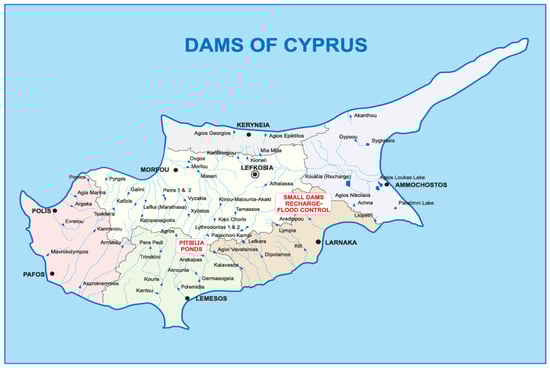
Figure 1.
Map of Cyprus with water reservoir (dams-blue triangles) locations (Cyprus Water Development Department).
In response to global water shortages exacerbated by population growth and climate change, an increasing number of countries have been deploying cloud seeding programs for rainfall enhancement [4,5,6,7], aiming to diversify national water strategies and build more resilient water–food–energy nexuses. Cloud seeding is a proven technology subset of weather modification practices, reported on by the UN World Meteorological Organization (WMO), to augment natural rainfall amounts by altering microphysical processes of specific cloud types. To date, the WMO acknowledges two methods to modify cloud microphysical processes for improving precipitation efficiencies. One is through the alteration of liquid-phase clouds (without ice), done by dispersing hygroscopic (water-attracting) materials at cloud base with sufficient updrafts (base seeding). The other is used with clouds sufficiently cold to support ice-phase processes, in which cases glaciogenic (ice-forming) materials are used (top or bottom seeding with sufficient updrafts). In terms of operational platforms, manned aircraft-based cloud seeding remains the single demonstrated operational platform for airborne cloud seeding. More recently, ground-based seeding (i.e., ground-based flare trees) have been deployed by operational programs on high (or complex) terrain experiencing frequent orographic convection where vertical winds can transport the seeding material aloft into low-altitude cloud bases.
This study presents a preliminary feasibility assessment of cloud seeding for rain enhancement in Cyprus, leveraging a dataset comprised of rain gauge records, thunderstorm activity, and local X-band weather radar data. Operational components of a rain enhancement program are highlighted including convective weather forecasting, radar and satellite monitoring systems, seeding aircrafts, communications, data gathering and management and an operations center that coordinates all activities. A research component, with continuous data collection and analysis is also integral, allowing the program to assess effectiveness and evaluation, refine strategies, and ensure safety and environmental compliance.
2. Cyprus Regional Setting and Rainfall Climatology
Preliminary studies of the local meteorology and cloud microphysics are essential requirements for cloud seeding programs. The potential for increases in rainfall using cloud seeding is strongly dependent on the natural microphysics and dynamics of the clouds that are being seeded. Microphysics means the size and concentration of water droplets and ice particles inside clouds. Dynamics means the forces affecting air motions in and around clouds. The microphysics are dependent on background aerosol levels, because it is the aerosol particles that attract water vapor to form cloud droplets, and in cold clouds, ice particles. Given these dependencies, the microphysics of clouds can differ significantly from one geographical region to another, and even between seasons in the same region. In some instances, clouds may not be suitable for seeding, or the frequency of these clouds may be too low to warrant the investment in a cloud seeding program.
The island of Cyprus is situated in the northeastern most corner of the Mediterranean Sea (Figure 2); therefore, it exhibits a typical eastern Mediterranean climate. The combined temperature–rainfall regime is characterized by cool-to-mild, wet winters and warm-to-hot, dry summers. In terms of orography, the island is transversed by two mountain ranges, the high Troodos Massif in the southwest with the highest peak, Olympus at 1951 m, and the elongated narrow Pentadaktylos range, rising to 900 m and bordering the northern coast. Between the two mountain ranges, lies the central plain and along their seaward margins a narrow coastal strip.
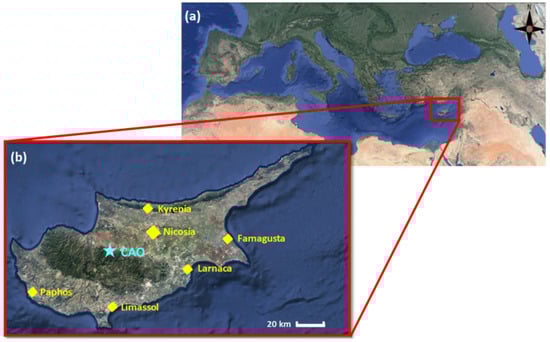
Figure 2.
Regional setting of Cyprus (a) and inset map of Cyprus with the major districts labelled in yellow (b) CAO refers to the Cyprus Institute Atmospheric Observatory—Agia Marina station, which would be an ideal location for installing the proposed C-band radar.
The Mediterranean region is connected to the large-scale atmospheric Hadley circulation, driven by deep tropical cumulonimbus clouds that are accompanied by descent in the subtropics. This is most pronounced during winter. The low-level flow in the subtropics is characterized by vast anticyclones in which precipitation is suppressed. These occupy about 40% of the Earth’s surface. During the eastern Mediterranean summer, a teleconnection with the Asian monsoon plays a key role [8]. The monsoon convection acts as a remote dynamic that is enhanced by radiative cooling in the subsidence region, a positive feedback that adds to the drying. The tropics are expanding [9] and the Asian monsoon is intensifying under the influence of global warming. Robust climate modeling indicates that subsidence and dryness over the eastern Mediterranean will increase [10].
2.1. Rainfall Regime
Figure 3 shows the long-term (1991–2024) mean monthly rainfall recorded over the six main districts of Cyprus. The data shows a normalized distribution with mean monthly rainfall exceeding 20 mm during the 7-month period of October–April, with peaks exceeding 100 mm during December through January. Further analysis of daily rainfall indicates up to 16 events per month during October–April. Alternatively, up to 6 events per month are observed during the May–September period, localized over the central highlands, which may offer potentially suitable sites for deploying ground-based flare trees to augment aircraft seeding operations when cloud bases are sufficiently low (not safely reachable by seeding aircraft). Importantly, more than 90% [11] of the wintertime rainfall events are situated in the central region—well beyond the northern occupied territories of the country, which are excluded from any planned cloud seeding operations.
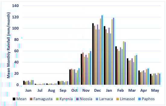
Figure 3.
Mean monthly rainfall (1991–2024) distributions obtained from local rain gauge records.
- October to April: Most of the rainfall occurs during the colder months of the year, with Cyprus receiving approximately 75% of its annual rainfall in this period. The rain is typically in the form of heavy thunderstorm showers, often associated with low-pressure systems that move across the Eastern Mediterranean.
- May to June: Rainfall and thunderstorm activity significantly decreases after half of Spring. Showers become sporadic, and by the end of June, Cyprus enters a dry spell.
- July to September: The warmest months of the year are extremely dry, with little to no rainfall. Average temperatures can reach as high as 30–35 °C, and the island experiences drought conditions.
2.2. Thunderstorm Activity
In addition to the rain gauge data, lightning data were examined to further characterize convective activity. Figure 4 presents a sample of lightning occurrences over Cyprus on 17 October 2022 (a) and the annual average thunderstorm days over Europe and the Mediterranean during 2008–2017 (b) [12].
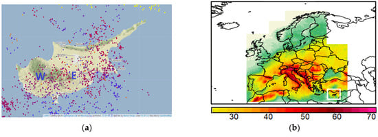
Figure 4.
(a) Lightning occurrences (red and blue dots) over Cyprus on 17 October 2022 (www.Blitzortung.org) and (b) annual average thunderstorm days over Europe and the Mediterranean [12].
Potential cloud seeding days were determined based on the long records of rain and lightning–thunderstorm activity. Cloud seeding can be conducted in clouds with sufficient moisture and vertical development, during rainy and convective weather days. Estimated cloud seeding potential days were based on a lightning-thunderstorm data sample for western (W), eastern (E) and the total west-east (T) regions including an approximate 10-km zone of sea areas of Cyprus for the period 2021–2025 (Figure 4 and Figure 5 and Table 1).
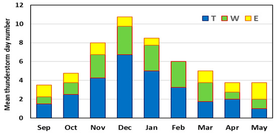
Figure 5.
Average monthly thunderstorm day number based on thunderstorm–lightning data (September 2021–May 2025) for western (W), eastern (E) and total (T) western–eastern Cyprus region.

Table 1.
Thunderstorm days and estimated cloud seeding day number for Cyprus.
A total of 47 to 56 days of seeding is expected based on thunderstorm data for the 9-month period, September to May. Based on convective activity as defined by lightning–thunderstorm data, the cloud seeding potential is likely most confined to the October–April window (~50 seeding days), with fewer opportunities from May to September.
- Regional thunderstorm occurrences record a 40–50 days annual average over the central–west regions, with a maximum of 50–60 day over Troodos Mountains in the central and Limassol–Akrotiri in the southernmost parts of Cyprus days (Figure 4b).
- In all months from October to February and in April, convective activity is mostly affecting the total (T) Cyprus area.
- December represents the peak regional thunderstorm frequency (~10.5 days) and the largest extent of activity, with a notable extent in the western region (W) and some in the eastern region (E).
- November and January also show elevated thunderstorm activity (8 to 9 days), with a similar distribution in the regions.
- February and March follow (5–6 thunderstorm days), with prominent activity also in the W region.
- April and May indicate a gradual decline in thunderstorm days, with E region becoming relatively more active by May.
- September has lower thunderstorm frequencies, averaging 3 to 4 days.
In summary, convective activity in Cyprus indicates a seasonal pattern, aligning from October until May, with the peak activity during the colder period of the year (November–January). The shift of convection from W (western) region to the E (eastern) region from March to May suggests changing atmospheric conditions (circulation patterns, etc.).
2.3. Radar Data Analysis
In addition to the rain gauge and lightning records, local X-band weather radar observations were provided by the Cyprus Department of Meteorology (DoM) from the Paphos and Larnaca radars for the period of 30 October 2024 to 4 January 2025.
The provided raw HDF5 radar files were converted into Cartesian netCDF format, mosaicking the two radar coverages using maximum reflectivity field. The data was gridded at 10-min intervals (from 04:00–17:00 UTC each day), producing daily maximum-reflectivity composite images using the Thunderstorm Identification, Tracking, Analysis, and Nowcasting (TITAN) software [13]. The processed radar data was used to investigate potential cloud seeding targets using radar reflectivity and cloud depth thresholds:
- Convective storm frequency: Storm tracks were counted when they exceeded 30 dBZ reflectivity at 2 km MSL and a 15 km3 volume. This quantified how often sizeable thunderstorms occurred during the analysis period.
- Glaciogenic seeding candidates: Echoes with reflectivity ≥25 dBZ at ~5 km height MSL. This altitude corresponds to roughly the −10 °C level from ERA5 climatology over Cyprus, meaning these clouds likely contain supercooled liquid water, a prerequisite for effective glaciogenic seeding.
- Hygroscopic seeding candidates: Echoes with reflectivity ≥10 dBZ that persist through ≥4 km of vertical depth, with bases in the ~1.0–2.5 km MSL range. These criteria ensure a sufficiently thick warm cloud layer for hygroscopic seeding to trigger a strong collision–coalescence process.
Notable anomalies in the radar dataset included two radar outage periods (24–25 November 2024, and 11–12 December 2024, when no data were available) and an azimuthal misalignment in the Paphos radar data after 13 December 2024 (causing a slight directional offset in Paphos echo locations). Despite these issues, several radar echoes met the preliminary seedability criteria across different parts of Cyprus during this short (~2 month) time period. This radar analysis provides the first sample of direct observational evidence of seedable cloud structures over Cyprus.
Figure 6 shows the hourly histogram of TITAN-identified convective storm occurrences (cells > 30 dBZ at 2 km MSL with volume > 15 km3) across Cyprus during 30 October 2024 to 4 January 2025. In total, 62 storms were initiated, and 94 storms occurred over the ~2-month study period. This analysis was limited to the daily period of 04:00 and 17:00 UTC to focus on daylight seeding opportunities. Hence, a portion of storms recorded as initiating at 0400 UTC may be holdovers from existing nocturnal convection. The histogram shows a nearly bimodal daytime diurnal cycle of storm initiation with peaks around noon (7) and late afternoon (11). Storm initiation is low in the early hours, gradually increasing throughout the day, while total storm occurrences show a sharp rise after midday. However, the analysis is limited by the short data period (~2 months), which does not capture seasonal variability or extreme events.
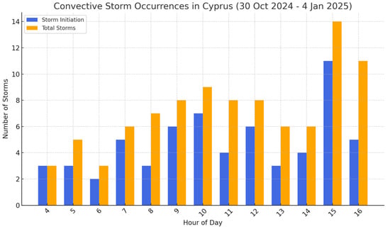
Figure 6.
Hourly (times UTC) histogram of TITAN-identified convective storm occurrences (cells > 30 dBZ at 2 km MSL with volume > 15 km3) across Cyprus during 30 October 2024 to 4 January 2025.
Figure 7 shows the spatial distribution of radar echoes meeting the glaciogenic seeding criterion, defined as reflectivity ≥ 25 dBZ at 5 km MSL This altitude matches the climatological −10 °C level over Cyprus for the October to January based on ERA5 reanalysis, representing the mixed-phase region where supercooled liquid water is typically present.
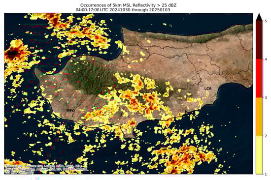
Figure 7.
Spatial distribution of radar reflectivity ≥25 dBZ at 5 km MSL (glaciogenic seeding po-tential) for the period 30 October 2024 to 3 January 2025.
The map shows that suitable cold-cloud targets occurred frequently along the southern slopes of the Troodos Mountains, consistent with orographic enhancement, and extended to the coast where maritime convection was observed. These results demonstrate that multiple storm systems during the analysis period developed sufficient vertical extent and intensity (up to 5 cells in coincident locations), suitable for effective glaciogenic seeding operations. Figure 8 presents the spatial distribution of radar echoes meeting the hygroscopic seeding criterion, defined as reflectivity ≥ 10 dBZ persisting through at least 4 km of vertical depth, with bases between 1.0 km and 2.5 km MSL. This threshold corresponds to a warm-cloud depth sufficient to support efficient collision–coalescence processes, as identified in previous warm-rain enhancement studies [4]. The results highlight frequent occurrences (up to 10 coincident cells) of such deep warm clouds offshore to the southwest and south of Paphos, extending inland into low-elevation agricultural areas. Additional hotspots were observed along the southern coastal plain and, on several occasions, within the windward slopes of the Troodos Mountains. These patterns suggest that both maritime and orographic convection during the study period can produce warm-cloud structures suitable for hygroscopic seeding. The offshore occurrences, in particular, present operational opportunities for early targeting before clouds move inland, maximizing rainfall enhancement potential over catchment areas.
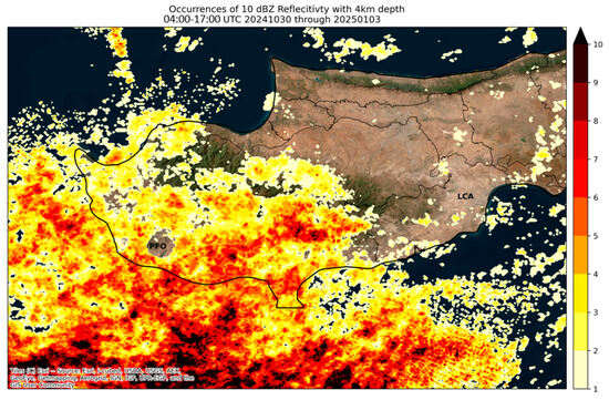
Figure 8.
Spatial distribution of radar echoes ≥ 10 dBZ with at least 4 km of vertical extent (hygroscopic seeding potential) observed over Cyprus from 30 October 2024 to 3 January 2025.
Figure 9a depicts an example of an intense convective cell observed south–central Cyprus during the study period, with composite reflectivity exceeding 45–50 dBZ in the core. The vertical cross-section (Figure 9b) reveals echo tops surpassing 10 km MSL and strong reflectivity (>30 dBZ) extending well through the mixed-phase region, indicating abundant supercooled liquid water aloft.
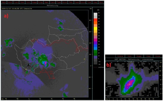
Figure 9.
Example of an intense convective cell captured by radar (Rview): echo tops above 10 km with a core > 45 dBZ (a) and cross-section highlights the storm’s vertical structure (b).
The vertical structure shows a deep convective column with sustained updrafts capable of supporting both warm-cloud and cold-cloud precipitation processes. Such storms represent optimal dual-mode seeding opportunities, where hygroscopic flares could accelerate raindrop growth in the warm layer, while glaciogenic flares could enhance ice formation in the supercooled upper portions. This case further illustrates the ability of the Cyprus radar network to detect and characterize convective storm structure in real time, providing a robust basis for data-driven seeding decisions.
Previous studies in neighboring Israel indicate that convective clouds in the Eastern Mediterranean, including Cyprus, do not exhibit strong continental features (high concentrations within a narrow distribution of cloud droplet sizes). Instead, are often microphysically more maritime in nature and subject to natural hygroscopic seeding by sea spray or mineral dust particles coated with soluble material [14]. Concurrent data collection (upper air and radar data) gathered during the program will provide more insight into the potential effectiveness of hygroscopic seeding for future operations.
3. Proposed Cloud Seeding Program Framework
The proposed Cloud Seeding Program facilities include an operations center, radar network, aircraft, seeding equipment, seeding flares, and the ancillary hardware and other infrastructure used by the Program. In close collaboration with the Cyprus DoM, the Program will leverage the existing national meteorological infrastructure, including the current X-band radar network, upper-air soundings, automatic weather stations and local forecasts. An operations center will be set up within the DoM building in Nicosia to direct all Program elements, namely, Numerical Weather Prediction (NWP) and data visualization, weather radar displays, and aircraft-to-operations telemetry (data and voice).
For cloud seeding aircraft to operate from an airfield in Cyprus certain essential services must be available. These include ground handling and fueling services, security, and expeditious access to supplies of cloud seeding flares. Fulfillment of these requirements will allow seeding aircraft to land, refuel, resupply seeding flares, and depart to seed additional clouds. Airport traffic, security, ground services, and fueling each present normal challenges that project personnel will collaboratively overcome with airport authorities. Such challenges are a normal part of program development and are expected to be minimal given the planned close collaboration with local stakeholders. Preliminary investigations indicate that two cloud seeding aircraft will be based out of Paphos Airport (PFO). A proper and accessible storage area will be dedicated for the cloud seeding flares. A specialized crew and supporting ground staff will reside in the vicinity of PFO.
The WMO provides clear guidelines on how a nation should proceed when considering intentional weather modification to augment water resources. The most updated guidelines were published in 2015 with a recommendation that cloud seeding programs should be planned to last many years to gather a sufficient volume of measurements to produce scientifically significant results [15]. Hence, this initial 7-month deployment is not expected to produce scientifically meaningful results. However, clearly defined operational Key Performance Indicators (KPIs) will indicate operational readiness to sustain a long-term program, which would permit a scientific evaluation by integrating radar observations, research aircraft measurements and cloud-scale modeling case studies. These factors need to be evaluated in a climatological sense over a sufficient period of time to account for natural variations using a randomization procedure to statistically report on precipitation increases. Such a randomized statistical experiment would become the second phase of a future program, building on learnings from other randomized experiments performed under similar conditions.
Cloud seeding impact assessment is typically achieved through one (or more) of four methods. In an ideal scenario, all evaluation methods would be conducted for cross-validation, but any individual method provides important scientific insights as noted below:
- Cloud-scale Simulations: to compare simulated rainfall amounts between seeded and unseeded (natural) clouds. Several sources of uncertainty/bias across different model systems remain a major challenge. The models require input from actual observations sourced from one (or more) of the below three methods.
- Weather Radar Observations: Weather radar measurements using existing X- or C-band radars in Cyprus. All seeding mission logs would be archived and examined for seeding signatures over multi-year periods.
- Rain Gauge Data: Control-target statistical analysis to compare historical (unseeded) with seeded periods once a statistically representative dataset from seeding operations is collected (5+ years). The major uncertainty here lies in de-coupling the trend of natural rainfall variability, but there are several statistical approaches to isolate and minimize this effect.
- Research Aircraft Measurements: Deploy an instrumented cloud physics research aircraft for periods of 4–6 weeks within the 7-month operational program to collect in-cloud microphysical and aerosol measurements. The research aircraft would sample seeded clouds in conjunction with a seeding aircraft and natural/unseeded clouds to examine microphysical changes between the two over a large number of cases.
4. Conclusions
Climate change is expected to exacerbate water shortages in Cyprus by increasing the frequency and intensity of droughts, reducing rainfall, and raising temperatures. This puts additional pressure on agriculture, ecosystems, and urban water supply. Cyprus is implementing its national adaptation strategy through a national action plan. To support the strategy and the action plan, Cyprus intends to coordinate climate adaptation in the eastern Mediterranean and the Middle East. A cloud seeding program will form a key component of nature-based climate change adaptation initiatives.
Our preliminary analyses from historical rainfall and lightning records suggest an initial 7-month (October–April) program out of Paphos Airport with up to 48 seeding opportunities. Radar analysis confirmed frequent occurrences of seedable clouds meeting both glaciogenic and hygroscopic seeding criteria, particularly over the Troodos Mountains, southern coastal plains, and maritime inflow zones. Though the cloud seeding program is not proposed as an alternative to desalination technology, preliminary cost–benefit analyses based on the climatology and geographic setting of Cyprus indicate desalination cost savings of €26 million annually, associated with a targeted 10% average annual increase in natural rainfall through cloud seeding. Finally, adding to the cost incentive, the existing emission reduction strategies planned by Cyprus are not sufficient (~7–17%) to reach the 32% target by 2030 compared to the 2005 level. Aircraft operations from cloud seeding would amount to less than 0.05% of emissions resulting from desalination plants.
Author Contributions
Conceptualization, M.S. and Y.W.; methodology, M.S., Y.W. and A.B.; software, A.B.; validation, D.L., Y.W. and B.B.; formal analysis, Y.W. and M.S.; investigation, Y.W. and M.S.; resources, Y.W.; data curation, A.B. and Y.W.; writing—original draft preparation, M.S.; writing—review and editing, Y.W., D.L. and B.B.; visualization, A.B. and Y.W.; supervision, D.L. and Y.W. All authors have read and agreed to the published version of the manuscript.
Funding
This research received no external funding.
Institutional Review Board Statement
Not applicable.
Informed Consent Statement
Not applicable.
Data Availability Statement
The radar and rain gauge data used in this study is available upon request from the Cyprus Department of Meteorology. The lightning data is retrieved from www.Blitzortung.org (accessed on 15 June 2025).
Acknowledgments
The authors acknowledge the coordination support from the G.A.P. Vassilopoulos Group with the Cyprus Department of Meteorology for data provision.
Conflicts of Interest
All authors were employed by the company is Weather Modification International and declare that the research was conducted in the absence of any commercial or financial relationships that could be construed as a potential conflict of interest.
References
- Zachariadis, T. Residential Water Scarcity in Cyprus: Impact of Climate Change and Policy Options. Water 2010, 2, 788–814. [Google Scholar] [CrossRef]
- Lazoglou, G.; Hadjinicolaou, P.; Sofokleous, I.; Bruggeman, A.; Zittis, G. Climate change and extremes in the Mediterranean island of Cyprus: From historical trends to future projections. Environ. Res. Commun. 2024, 6, 095020. [Google Scholar] [CrossRef]
- CyprusMail. Available online: https://cyprus-mail.com/2024/06/26/e351-3-million-supplementary-budget-for-meds-defence-and-water (accessed on 26 May 2025).
- Mouskos, P. The Potentiality of Application of Rain Enhancement Projects in the Area of Cyprus. Ph.D. Thesis, Aristotle University of Thessaloniki, Thessaloniki, Greece, 2022; 135p. (In Greek). [Google Scholar]
- Flossmann, A.; Manton, A.I.; Abshaev, M.J.; Bruintjes, R.; Murakami, M.; Prabhakaran, T.; Yao, Z. Peer Review Report on Global Precipitation Enhancement Activities; United Nations; World Meteorological Organization (WMO): Geneva, Switzerland, 2018. [Google Scholar]
- Flossmann, A.I.; Manton, M.; Abshaev, A.; Bruintjes, R.; Murakami, M.; Prabhakaran, T.; Yao, Z. Review of advances in precipitation enhancement research. Bull. Am. Meteor. Soc. 2019, 100, 1465–1480. [Google Scholar] [CrossRef]
- Wehbe, Y.; Griffiths, S.; Al Mazrouei, A.; Yazeedi, O.; Al Mandous, A. Rethinking water security in a warming climate: Rainfall enhancement as an innovative augmentation technique. Clim. Atmos. Sci. 2023, 6, 171. [Google Scholar] [CrossRef]
- Rodwell, M.J.; Hoskins, B.J. Monsoons and the dynamics of deserts. Q. J. R. Meteorol. Soc. 1996, 122, 1385–1404. [Google Scholar] [CrossRef]
- Seidel, D.J.; Fu, Q.; Randel, W.J.; Reichler, T.J. Widening of the tropical belt in a changing climate. Nat. Geosci. 2008, 1, 21–24. [Google Scholar] [CrossRef]
- Christensen, J.H.; Christensen, O.B. A summary of the PRUDENCE model projections of changes in European climate by the end of this century. Clim. Change 2007, 81 (Suppl. S1), 7–30. [Google Scholar] [CrossRef]
- Retalis, A.; Katsanos, D.; Michaelides, S. Precipitation climatology over the Mediterranean Basin—Validation over Cyprus. Atmos. Res. 2016, 169, 449–458. [Google Scholar] [CrossRef]
- Taszarek, M.; Allen, J.; Pucik, T.; Groenemeuer, P.; Czernecki, B.; Kolendowicz, L.; Lagouvardos, K.; Kotroni, V.; Schulz, W. A Climatology of Thunderstorms across Europe from a Synthesis of Multiple Data Sources. J. Clim. 2019, 32, 1813–1837. [Google Scholar] [CrossRef]
- Dixon, M.; Wiener, G. TITAN: Thunderstorm Identification, Tracking, Analysis, and Nowcasting—A Radar-based Methodology. J. Atmos. and Ocea. Tech. 1993, 6, 785. [Google Scholar] [CrossRef]
- Levin, Z. On the State of Cloud-Seeding for Rain Enhancement; The Cyprus Institute: Aglandjia, Cyprus, 2009. [Google Scholar]
- World Meteorological Organization. WMO Statement on Weather Modification; Technical Report; World Meteorological Organization (WMO): Geneva, Switzerland, 2015. [Google Scholar]
Disclaimer/Publisher’s Note: The statements, opinions and data contained in all publications are solely those of the individual author(s) and contributor(s) and not of MDPI and/or the editor(s). MDPI and/or the editor(s) disclaim responsibility for any injury to people or property resulting from any ideas, methods, instructions or products referred to in the content. |
© 2025 by the authors. Licensee MDPI, Basel, Switzerland. This article is an open access article distributed under the terms and conditions of the Creative Commons Attribution (CC BY) license (https://creativecommons.org/licenses/by/4.0/).