Proceeding Paper

Orographic Effect’s Correlation with Convection During a Low-Pressure System Passage over Greece in September 2023 †

by
Sotirios T. Arsenis
1,2,*,
Ioannis Samos
3,4 and
Panagiotis T. Nastos
1
1
Laboratory of Climatology and Atmospheric Environment, National and Kapodistrian University of Athens, University Campus, 15784 Athens, Greece
2
AXON Enviro-Group Ltd., 18 Troias Str., 11257 Athens, Greece
3
Section of Environmental Physics and Meteorology, Department of Physics, National and Kapodistrian University of Athens, 15772 Athens, Greece
4
Hellenic National Meteorological Service, Hellinikon, 16777 Athens, Greece
*
Author to whom correspondence should be addressed.
Presented at the 17th International Conference on Meteorology, Climatology, and Atmospheric Physics—COMECAP 2025, Nicosia, Cyprus, 29 September–1 October 2025.
Environ. Earth Sci. Proc. 2025, 35(1), 37; https://doi.org/10.3390/eesp2025035037
Published: 17 September 2025

Abstract

Extreme rainfall events are frequently associated with regions of complex topography, where terrain-induced convergence and uplift enhance storm development. Understanding the interaction between surface relief and atmospheric dynamics is essential for improving severe weather forecasting and hazard mitigation. Storm “Daniel”, which affected Greece from 4–7 September 2023, produced extreme rainfall and widespread flooding in the Thessaly region—a landscape characterized by significant elevation gradients. This study investigates the spatial relationship between lightning activity and terrain elevation, aiming to assess whether deep convection was preferentially triggered over mountainous regions or followed specific orographic patterns. High-resolution elevation data (SRTM 1 Arc-Second Global DEM) were used to calculate the mean elevation around each lightning strike across four spatial scales (2 km, 5 km, 10 km, and 20 km). Statistical analysis, including correlation coefficients and third-degree polynomial regression, revealed a non-linear relationship, with a distinct peak in lightning frequency at mid-elevations (~200–400 m). These findings suggest that topographic features at local scales can significantly modulate convective initiation, likely due to a combination of mechanical uplift and favorable thermodynamic conditions. The study integrates geospatial techniques and statistical modeling to provide quantitative insights into how terrain influences the formation, location, and intensity of thunderstorms during high-impact weather events.

1. Introduction

Extreme rainfall events are a significant component of severe weather systems, causing devastating floods, infrastructure damage, and loss of human lives. The prediction of such phenomena is particularly challenging, especially in regions with complex topography, where the interaction between the atmosphere and the terrain can enhance storm dynamics [1,2]. Orographic effects can modify atmospheric circulation on local, meso-, and synoptic scales, inducing additional mechanisms of upward air motion and reinforcing convergence and uplift processes [3].
Convection, the vertical transport of heat and moisture, is the primary mechanism leading to thunderstorm formation [4]. For deep convection to occur, at least one of the following fundamental conditions must be met: (a) High moisture content in the lower troposphere [5,6], (b) Atmospheric instability, where warmer air masses are located below cooler ones, allowing for upward motion, and (c) A lifting mechanism, such as orography or dynamic convergence, to trigger convection [7]. In addition to these, interactions within the planetary boundary layer can significantly influence convective initiation by modulating near-surface instability and enhancing low-level convergence [8].
Mountainous regions act as natural lifting mechanisms, forcing air masses to ascend due to changes in elevation [9]. This phenomenon can lead to cooling and condensation of water vapor, enhancing the formation of cumulonimbus clouds and intense thunderstorms. This study is motivated by the critical role that deep convection plays in precipitation and the fundamental influence of terrain in shaping this process [10,11].
Previous studies [12] have shown that in regions with significant topographic variations, lightning activity is more frequent due to the additional enhancement of convection dynamics. The relationship between lightning activity and elevation is non-linear [13], exhibiting different spatial distributions in marine and mountainous environments. Topographic features are known to enhance both dynamic and thermal mechanisms involved in the deep convection initiation (DCI) process [14,15]. Deep convection can be triggered dynamically when airflow encounters mountainous terrain acting as a barrier [16,17]. Nonetheless, the detailed interaction between the storm and the underlying terrain during this event has not been extensively investigated to date.
This study examines the influence of topography on thunderstorm activity, with a focus on determining whether storms preferentially form over mountainous terrain or exhibit spatial patterns closely linked to orographic features. By applying geospatial analysis and statistical techniques, the research quantifies the role of terrain in shaping both the spatial distribution and the intensity of thunderstorms, offering a clearer understanding of how topographic forcing interacts with atmospheric dynamics to drive extreme weather events.

2. Data and Methodology

High-resolution elevation data was used from the Shuttle Radar Topography Mission (SRTM) 1 Arc-Second Global [18], providing a horizontal resolution of approximately 30 m. The data were obtained from the Earth Explorer platform of the USGS, ensuring a detailed representation of the terrain in the study area. The high spatial resolution of the Digital Elevation Model (DEM) allows for an accurate assessment of topographic features related to the development of thunderstorms [19].
Lightning data was provided by the Hellenic National Meteorological Service (HNMS), including geographical coordinates (latitude and longitude) and timestamps of lightning for 4–7 September 2023.
The methodology employed to investigate the relationship between topography and thunderstorm activity was based on a combination of geospatial analysis and statistical modeling [20]. For each lightning strike, the mean elevation was calculated within four concentric buffer zones: 2 km, 5 km, 10 km, and 20 km. These calculations were performed using high-resolution data from the SRTM 1 Arc-Second Global DEM (spatial resolution ~30 m), providing a detailed representation of the terrain.
The analysis was carried out using GIS techniques and the Python programming language (version 3.13). Initially, correlation analysis was performed by computing both the Pearson and Spearman correlation coefficients in order to assess the linear and non-linear relationships, respectively, between mean elevation and lightning density [21]. The statistical significance of the results was evaluated using p-values.
Polynomial regression was applied independently for each spatial radius based on binned elevation values.
By analyzing the above datasets, the relationship between topography and lightning activity is evaluated, enabling a contribution to an enhanced understanding of the convection in areas with complex terrain.

3. Results

This study focuses on Storm Daniel, which impacted Greece from 4–7 September 2023. This event serves as a characteristic example of a powerful omega blocking pattern system [22], which interacted with the region’s complex terrain, significantly enhancing convection, leading to extreme rainfall and unprecedented widespread flooding in Thessaly, Greece (not shown). The results indicated that, although the linear indicators yielded statistically significant values, the linear correlation was not sufficient to explain the relationship. The distribution of the data clearly exhibited non-linear characteristics, with lightning activity showing a distinct peak at mid-elevations (~200–400 m) and a sharp decline beyond this range. This finding prompted the use of third-degree polynomial regression as a more appropriate method to model the observed behavior.
The prevailing atmospheric conditions rendered the atmosphere unstable on both September 4th and 5th, as they enhanced convergence and vertical transport (convection), resulting in the occurrence of heavy rainfall and the development of severe thunderstorms across most parts of the country, including the region of Thessaly, an area with pronounced elevation variations.
Lightning concentrations are observed over central mainland regions (Figure 1), particularly in areas of complex terrain, underscoring the significant role of orographic features in enhancing convective activity.
The statistical analysis highlights a negative correlation between lightning activity and the mean elevation surrounding each lightning location. This relationship was calculated across four different spatial scales, corresponding to buffer zones of 2 km, 5 km, 10 km, and 20 km. For each radius, the Pearson correlation coefficient and statistical significance (p-value) were calculated to evaluate the connection between topography and thunderstorm occurrence.
Results indicate a peak in lightning frequency at mid-range elevations (e.g., 200–400 m), suggesting that there may be an optimal altitude range for convective triggering during this event. The strongest correlation was observed at the 2 km radius, indicating that local terrain around lightning plays a more significant role in enhancing convection. As the radius increases, the correlation weakens, suggesting that the orographic influence becomes less localized and more dispersed across a broader scale.
Notably, the very low p-values across all four scales confirm that these correlations are statistically significant and not due to random variability. These findings support the hypothesis that terrain elevation influences convective development, particularly in areas with pronounced elevation gradients, by promoting upward air motion and thunderstorm initiation.
Furthermore, the results of a multiple linear regression analysis—with lightning counted as the dependent variable—reinforce the significance of mean elevation. At the 2 km scale, the regression coefficient for elevation was negative and statistically significant (β = −0.0007, p < 0.001), indicating that higher elevations around a lightning strike are associated with lower lightning frequency. The explanatory power of the model (R2 ≈ 0.082) suggests that elevation, combined with other terrain variables such as slope, meaningfully contributes to the spatial distribution of lightning activity, especially at the local scale.
Τhe role of mean slope correlated to lightning activity was also examined linearly, revealing variations in its relationship with lightning depending on spatial scale [23]. Specifically, in smaller buffers (2–5 km), the correlation between average slope and lightning presence was negative and particularly weak, suggesting that lightning tends to avoid areas with steep local inclines (not shown). In contrast, at larger scales (10–20 km), the correlation becomes positive and statistically significant (p < 0.001), with regression coefficients showing an increasing trend.
These findings suggest that lightning activity is positively influenced by the general mountainous morphology of the surrounding landscape—that is, by the proximity to large orographic systems. Therefore, slope appears to act as a regional-scale enhancer of air convergence and uplift, although it does not serve as a strong local predictor of lightning activity.
A key factor that contributed to the development of intense convection over the mainland regions appears to be the complex topography of the country. The correlation between mountainous terrain and the enhancement of convection is well established, especially under favorable atmospheric conditions such as those shaped by the presence of a deep low-pressure system. The upward motion of air induced by orographic lifting, combined with atmospheric instability, promotes the rapid development of vertically extended clouds and increases the likelihood of lightning activity, as lightning phenomena require convection as a precursor phase.
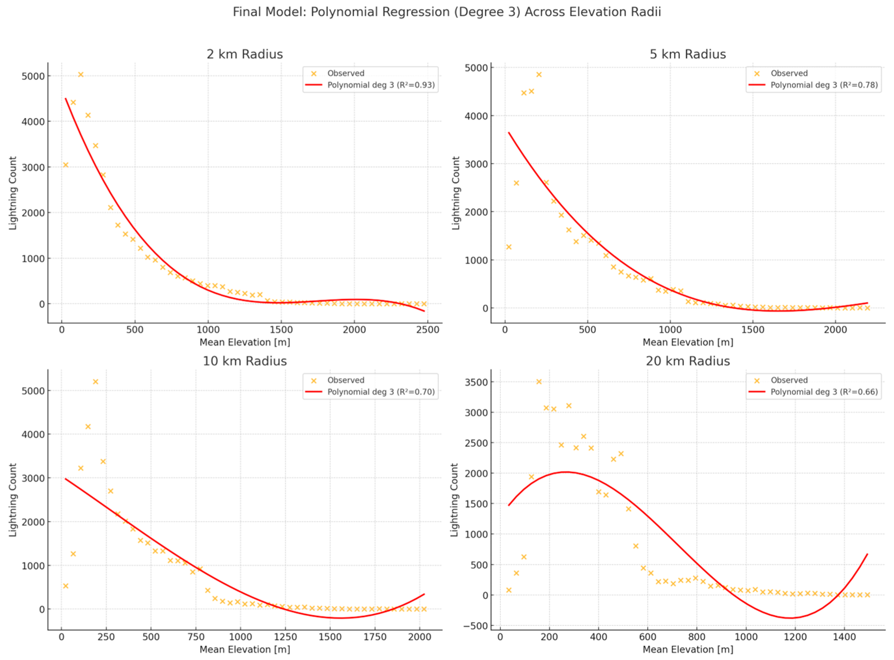
Furthermore, non-linear correlation was examined between datasets, as shown in Figure 2, using a third-degree polynomial model for regression.
At 2 km radius, the model achieves an excellent fit (R2 = 0.93), effectively capturing the sharp peak in lightning activity at lower elevations followed by a steep decline. At 5 km, the relationship is still strong (R2 = 0.78), though the curve becomes smoother, indicating that the influence of fine-scale topography begins to average out. At 10 km and 20 km, the model still explains a substantial portion of the variance (R2 = 0.70 and R2 = 0.66, respectively), but the relationship becomes progressively flatter, reflecting the diminishing role of local terrain features as the spatial radius increases.
Overall, results confirm that the interaction between elevation and lightning activity is scale-dependent, with local topographic effects being more prominent at smaller spatial scales.

4. Conclusions

The study highlighted the significant role of orography in enhancing convection during an extreme event, when an atmospheric disturbance affected the Greek region. Statistical analysis revealed a nuanced relationship between elevation and lightning activity: lightning density increases with elevation up to approximately 200 m, beyond which the correlation becomes negative across all spatial scales analyzed.
The statistical modeling further revealed that the interaction between elevation and lightning occurrence is inherently non-linear and influenced by spatial scale. The application of third-degree polynomial regression provided a significantly better fit than linear models, capturing subtle variations in lightning frequency across the elevation spectrum. As the analysis radius increased, the relationship between terrain and storm activity became progressively smoother and less pronounced, highlighting the diminishing sensitivity of convection to local terrain details at broader scales. This supports the view that orographic effects are most impactful when examined at fine spatial resolutions, and that a flexible modeling approach is necessary to fully characterize the terrain’s modulation of convective behavior.
Slope showed a weak negative correlation at local scales, but a positive and significant relationship at broader distances (10–20 km), indicating that large mountainous systems enhance convective processes. Overall, lightning activity appears to be influenced by the combined effect of atmospheric instability and terrain morphology.
This methodology enables a quantitative assessment of the impact of terrain elevation on thunderstorm development and the spatial distribution of lightning activity. It also provides a valuable framework for improving our understanding of how severe weather phenomena are modulated by surface geomorphology.

Author Contributions

Conceptualization, S.T.A. and I.S.; methodology, S.T.A. and I.S.; software, S.T.A.; validation, I.S. and P.T.N.; formal analysis, S.T.A.; investigation, S.T.A. and I.S.; resources, I.S. and S.T.A.; data curation, S.T.A.; writing—original draft preparation, S.T.A.; writing—review and editing, S.T.A. and I.S.; visualization, S.T.A., P.T.N.; supervision, I.S.; project administration, S.T.A. and I.S.; funding acquisition, not applicable. All authors have read and agreed to the published version of the manuscript.

Funding

This research received no external funding.

Institutional Review Board Statement

Not applicable.

Informed Consent Statement

Not applicable.

Data Availability Statement

The digital elevation data used in this study were obtained from the USGS EROS Archive–Digital Elevation–Shuttle Radar Topography Mission (SRTM) 1 Arc-Second Global, available online at https://www.usgs.gov/centers/eros/science/usgs-eros-archive-digital-elevation-shuttle-radar-topography-mission-srtm-1 (accessed on 9 February 2025). Lightning data was provided by the Hellenic National Meteorological Service (HNMS) and are not publicly available.

Conflicts of Interest

Author Sotirios T. Arsenis is employed by the company AXON Enviro-Group Ltd. The remaining authors declare that the research was conducted in the absence of any commercial or financial relationships that could be construed as a potential conflict of interest. All authors declare no conflict of interest.

References

  1. Katona, B.; Paul, M. Assessing the influence of complex terrain on severe convective environments in northeastern Alabama. Weather. Forecast. 2021, 36, 1003–1029. [Google Scholar] [CrossRef]
  2. Feldmann, M.; Rotunno, R.; Germann, U.; Berne, A. Supercell Thunderstorms in Complex Topography—How Mountain Valleys with Lakes Can Increase Occurrence Frequency. Mon. Weather. Rev. 2024, 152, 471–489. [Google Scholar] [CrossRef]
  3. Smith, G.M.; Lin, Y.-L. The Effects of Orographic Geometry on Supercell Thunderstorms. arXiv 2016, arXiv:1603.00579. [Google Scholar] [CrossRef]
  4. Kirshbaum, D.J.; Adler, B.; Kalthoff, N.; Barthlott, C.; Serafin, S. Moist orographic convection: Physical mechanisms and links to surface-exchange processes. Atmosphere 2018, 9, 80. [Google Scholar] [CrossRef]
  5. Taylor, C.M. Detecting soil moisture impacts on convective initiation in Europe. Geophys. Res. Lett. 2015, 42, 4631–4638. [Google Scholar] [CrossRef]
  6. Tian, Y.; Kuang, Z. Why does deep convection have different sensitivities to temperature perturbations in the lower versus upper troposphere? J. Atmos. Sci. 2019, 76, 27–41. [Google Scholar] [CrossRef]
  7. Fankhauser, J.C.; Crook, N.A.; Tuttle, J.; Miller, L.J.; Wade, C.G. Initiation of deep convection along boundary layer convergence lines in a semitropical environment. Mon. Weather. Rev. 1995, 123, 291–314. [Google Scholar] [CrossRef]
  8. Kirshbaum, D.J.; Dale, R.D. Factors governing cellular convection in orographic precipitation. J. Atmos. Sci. 2004, 61, 682–698. [Google Scholar] [CrossRef]
  9. Demko, J.C.; Geerts, B. A numerical study of the evolving convective boundary layer and orographic circulation around the Santa Catalina Mountains in Arizona. Part II: Interaction with deep convection. Mon. Weather. Rev. 2010, 138, 3603–3622. [Google Scholar] [CrossRef]
  10. Lu, G.; Ren, Y.; Fu, S.; Xue, H. Statistics of isolated deep convection initiation and its relation to topography in the North China area. J. Geophys. Res. Atmos. 2023, 128, e2022JD037949. [Google Scholar] [CrossRef]
  11. Langhans, W.; Gohm, A.; Zängl, G. The orographic impact on patterns of embedded convection during the August 2005 Alpine flood. Q. J. R. Meteorol. Soc. 2011, 137, 2092–2105. [Google Scholar] [CrossRef]
  12. Williams, E.; Rosenfeld, D.; Madden, N.; Gerlach, J.; Gears, N.; Atkinson, L.; Dunnemann, N.; Frostrom, G.; Antonio, M.; Biazon, B. Contrasting convective regimes over the Amazon: Implications for cloud electrification. J. Geophys. Res. Atmos. 2002, 107, LBA 50-1–LBA 50-19. [Google Scholar] [CrossRef]
  13. Albrecht, B.; Fang, M.; Ghate, V. Exploring stratocumulus cloud-top entrainment processes and parameterizations by using Doppler cloud radar observations. J. Atmos. Sci. 2016, 73, 729–742. [Google Scholar] [CrossRef]
  14. Houze Jr, R.A. Orographic effects on precipitating clouds. Rev. Geophys. 2012, 50, RG1001. [Google Scholar] [CrossRef]
  15. Whiteman, C.D. Mountain Meteorology: Fundamentals and Applications; Oxford University Press: Oxford, UK, 2000. [Google Scholar]
  16. Banta, R.M. Daytime boundary-layer evolution over mountainous terrain. Part 1: Observations of the dry circulations. Mon. Weather. Rev. 1984, 112, 340–356. [Google Scholar] [CrossRef]
  17. Banta, R.M.; Barker Schaaf, C. Thunderstorm genesis zones in the Colorado Rocky Mountains as determined by traceback of geosynchronous satellite images. Mon. Weather. Rev. 1987, 115, 463–476. [Google Scholar] [CrossRef]
  18. USGS EROS Archive–Digital Elevation–Shuttle Radar Topography Mission (SRTM) 1 Arc-Second Global. Available online: https://www.usgs.gov/centers/eros/science/usgs-eros-archive-digital-elevation-shuttle-radar-topography-mission-srtm-1 (accessed on 9 February 2025).
  19. De Meij, A.; Ojha, N.; Singh, N.; Singh, J.; Poelman, D.R.; Pozzer, A. The Impact of High-Resolution SRTM Topography and Corine Land Cover on Lightning Calculations in WRF. Atmosphere 2022, 13, 1050. [Google Scholar] [CrossRef]
  20. Hayward, L.; Whitworth, M.; Pepin, N.; Dorling, S. A comprehensive review of datasets and methodologies employed to produce thunderstorm climatologies. Nat. Hazards Earth Syst. Sci. 2020, 20, 2463–2482. [Google Scholar] [CrossRef]
  21. Dewan, A.M.; Yamaguchi, Y. Using remote sensing and GIS to detect and monitor urban land use change in Dhaka Metropolitan of Bangladesh during 1960–2005. Environ. Monit. Assess. 2009, 150, 237–249. [Google Scholar] [CrossRef] [PubMed]
  22. Nastos, P.T.; Feloni, E.; Paraskevas, A.; Matsangouras, I.T. Meteorological and Remote Sensing Analysis of the Severe Storm “Daniel” over Greece. In Proceedings of the European Geosciences Union General Assembly 2024 (EGU24), Vienna, Austria, 14–19 April 2024; p. 12908. [Google Scholar]
  23. Göbel, M.; Serafin, S.; Rotach, M.W. Adverse impact of terrain steepness on thermally driven initiation of orographic convection. Weather. Clim. Dyn. 2023, 4, 725–745. [Google Scholar] [CrossRef]
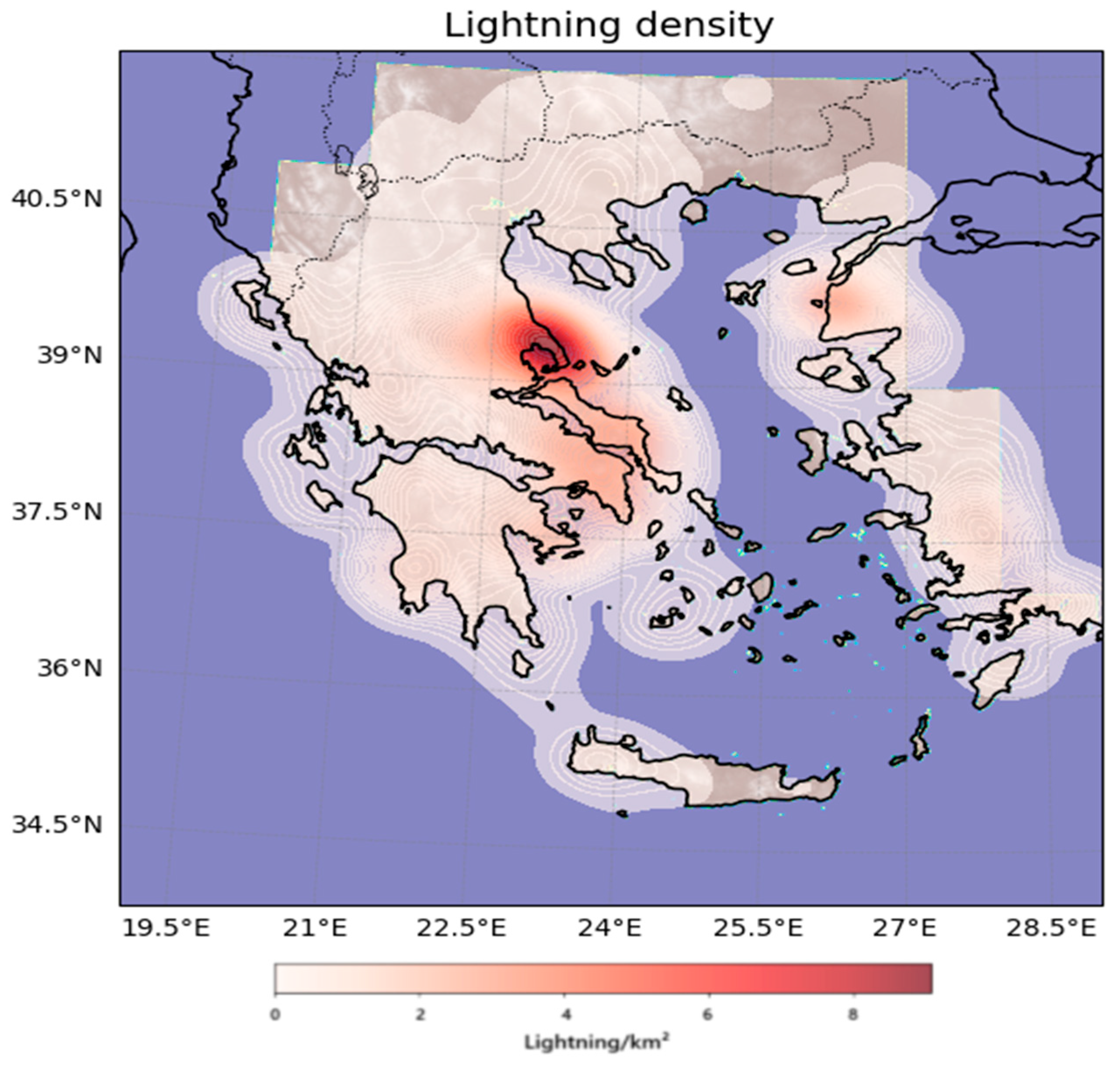
Figure 1. Spatial distribution of lightning density (in lightning/km2) during the period 4–7 September 2023.
Eesp 35 00037 g001
Figure 2. Final modeling approach using third-degree polynomial regression to examine the relationship between mean elevation and lightning frequency across four spatial scales (2 km, 5 km, 10 km, and 20 km). In all subplots, the observed lightning count (binned by elevation) is plotted alongside the fitted polynomial curve. This modeling framework more accurately captures the non-linear relationship between terrain elevation and lightning activity.
Eesp 35 00037 g002
Disclaimer/Publisher’s Note: The statements, opinions and data contained in all publications are solely those of the individual author(s) and contributor(s) and not of MDPI and/or the editor(s). MDPI and/or the editor(s) disclaim responsibility for any injury to people or property resulting from any ideas, methods, instructions or products referred to in the content.