1. Introduction
Wildfires constitute a growing environmental concern, particularly in the Mediterranean regions such as Greece, where rising temperatures, prolonged droughts, and human activity have contributed to more frequent and intense fire events. These events release large amounts of trace gases and particulate matter into the atmosphere, posing risks to ecosystems, public health, and air quality across broad geographic areas.
Biomass burning produces a complex mixture of emissions, including carbon monoxide (CO), carbon dioxide (CO
2), methane (CH
4), nitrogen oxides (NO
x), and particulate matter (PM). The composition and quantity of these emissions depend on the vegetation type, fire intensity, and meteorological conditions. Once released, these pollutants can be transported over long distances, degrading air quality far from the fire source. As such, the accurate modeling of both emissions and atmospheric dispersion is critical for applications ranging from air quality forecasting to climate assessment and emergency response [
1,
2].
This study presents a top-down emissions modeling framework based on Fire Radiative Power (FRP) data from the SEVIRI sensor on board Meteosat Second Generation. Hourly emissions from the July 2020 Korinthos wildfire in Greece were estimated and used to drive the FLEXPART dispersion model. The simulated smoke transport, vertical distribution and mass concentration were evaluated using observations from the TROPOMI instrument on board the Sentinel-5p satellite and ground-based lidar profiles from the PANGEA observatory of Antikythera island operated by the National Observatory of Athens (NOA). The approach demonstrates the value of high-temporal-resolution satellite data combined with dispersion modeling for monitoring wildfire impacts in real time.
2. Materials and Methods
2.1. Study Area and Fire Event
This study focuses on the Korinthos wildfire initiated on 22 July 2020 in the Northeastern Peloponnese region of Greece. Its short duration and high intensity, along with its proximity to urban areas, made it an ideal case study for evaluating high-temporal-resolution fire emission modeling and long-range smoke transport.
2.2. Satellite and Ground-Based Observations
FRP data were obtained from the SEVIRI sensor at 15-minute intervals and ~3 km spatial resolution. Data from the FRP-PIXEL product were processed through an automated pipeline to compute hourly Fire Radiative Energy (FRE). The steps included aggregating data on a 3 km × 3 km spatial grid and applying a 46% correction to account for low-FRP under-detection and converting FRP to FRE [
3]. FRE values were converted to Total Particulate Matter (TPM) and carbon monoxide (CO) emissions using emission coefficients (Ce) derived from the FREM model using function emission equal Ce * FRE. These Ce values, expressed in g MJ
−1, were obtained through regression analysis between observed FRP and satellite-derived Aerosol Optical Depth (AOD), stratified by land cover [
3].
To validate the simulations, daily columnar CO observations derived from TROPOMI data on Sentinel-5P satellite, were used. Additionally, lidar profiles from the PANGEA-NOA station were used to evaluate the vertical structure of the smoke plume [
4].
2.3. Meteorological Data and Model Setup
Meteorological data from the United States National Centers of Environmental Prediction (NCEP) Global Forecast System (GFS), with a spatial resolution of 0.25° at 3-htemporal intervals, were used to drive the FLEXPART model—a Lagrangian particle dispersion model designed to simulate the transport, dispersion, and deposition of atmospheric tracers [
5]. FLEXPART was used to model smoke dispersion from the Korinthos wildfire over the period 22–23 July 2020, using hourly TPM emissions derived from SEVIRI FRP data. Particles were released within the 0–1 km altitude range, reflecting estimated injection heights based on fire intensity. To realistically represent smoke properties, the simulated tracers followed a mono-modal lognormal mass size distribution with a mean diameter of d = 2 μm and a geometric standard deviation of σ = 2, to account for the effects of atmospheric aging that lead to particle growth beyond the typical submicron sizes found near sources [
6]. Dry and wet removal processes were applied to these particles. Two simulations were conducted: one using standard release settings and another employing the WARM START mode, which allows continuous particle injection at evolving fire locations, providing a more dynamic and realistic representation of the fire progression.
3. Results
3.1. Hourly CO Emissions from SEVIRI-FRP
Hourly total carbon monoxide (CO) emissions for 22 July 2020, the first day of the Korinthos wildfire, were derived from SEVIRI FRP data (
Figure 1). These emissions were calculated using biome-specific emission coefficients applied to hourly FRE values. The resulting estimates are expressed in gigagrams (Gg) and include uncertainty bands that reflect variations in both the FRP data and the emission factors used.
The emission profile shows a clear diurnal pattern, with a sharp rise from early morning values of 0.3–0.5 Gg to a peak of approximately 1.6 Gg between 13:00 and 14:00 UTC. Emissions then gradually decreased through the evening. The highest uncertainty coincides with periods of rapid change in emissions, underscoring the sensitivity of top-down estimates to fire intensity fluctuations and satellite retrieval precision [
7].
3.2. Visual Verification Using Sentinel-2 True Color Imagery
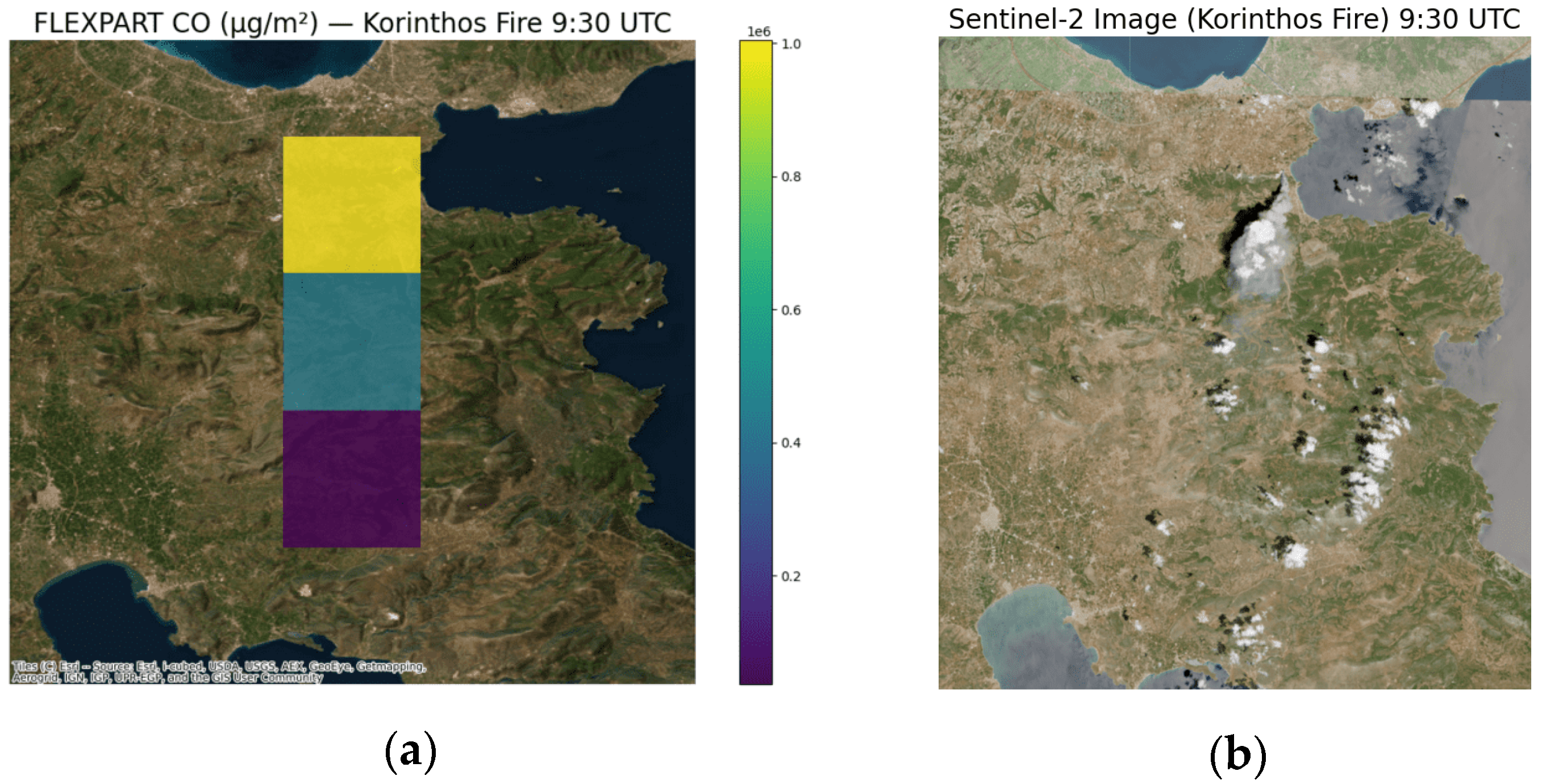
To evaluate the accuracy of the FLEXPART simulation during the early stage of the Korinthos wildfire, a comparison was made with Sentinel-2 true-color imagery captured at 09:30 UTC on 22 July 2020, shortly after the fire ignition around 09:00 UTC (
Figure 2). The FLEXPART output, based on SEVIRI-derived hourly emissions, shows the initial CO concentration plume dispersing northwards from the source. This modeled distribution closely simulates the Sentinel-2 image, which clearly depicts a visible smoke plume moving in the same direction.
3.3. Comparison with TROPOMI CO Observations
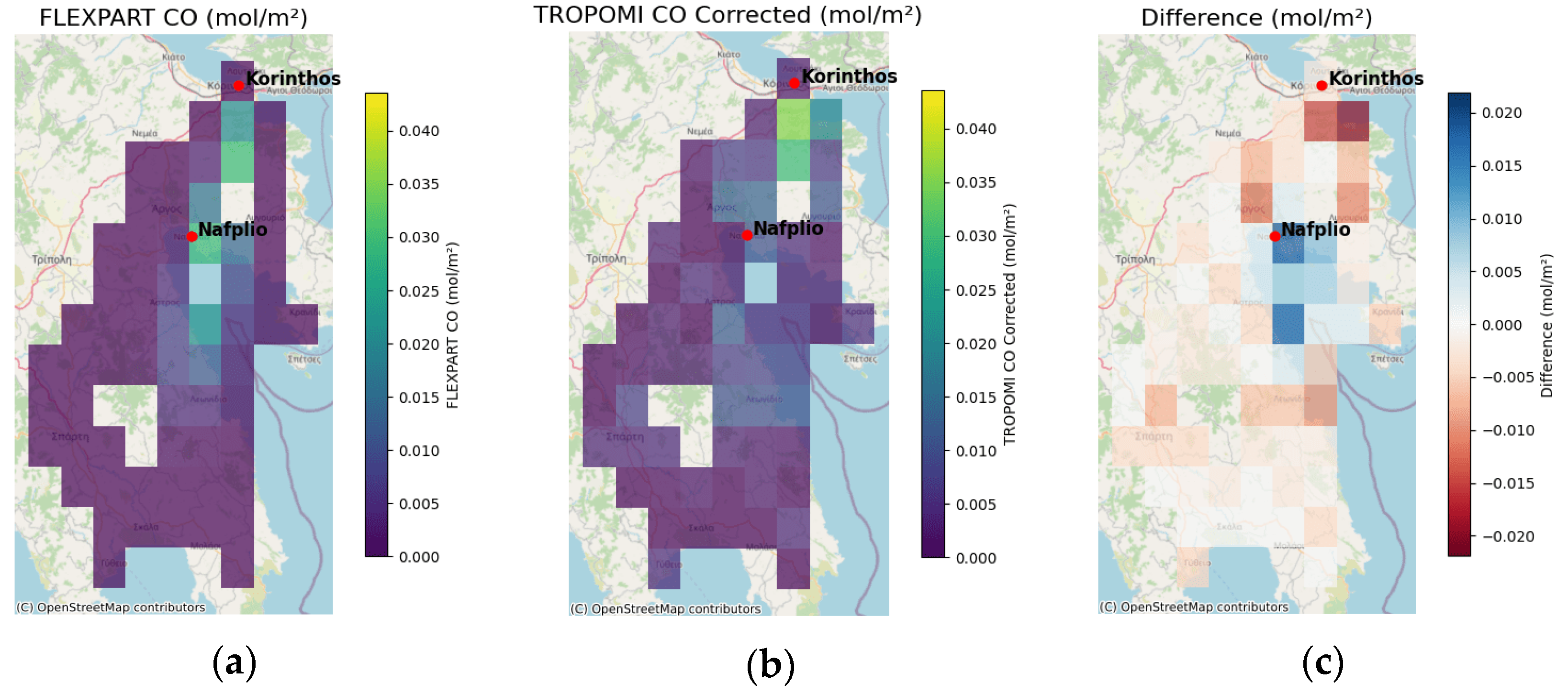
To further evaluate the spatial accuracy of the simulation, column-integrated CO concentrations from FLEXPART were compared against TROPOMI retrievals, which overpassed the fire area at approximately 11:00 UTC on 22 July 2020.
3.3.1. Standard FLEXPART Simulation (Without WARM START)
Figure 3 shows a three-panel comparison of (a) FLEXPART, (b) TROPOMI, and (c) their spatial difference. The general pattern of CO concentrations is reproduced, especially over the Korinthos–Nafplio axis. However, some mismatches are evident particularly near the fire origin and southern extent of the plume.
3.3.2. WARM START FLEXPART Simulation
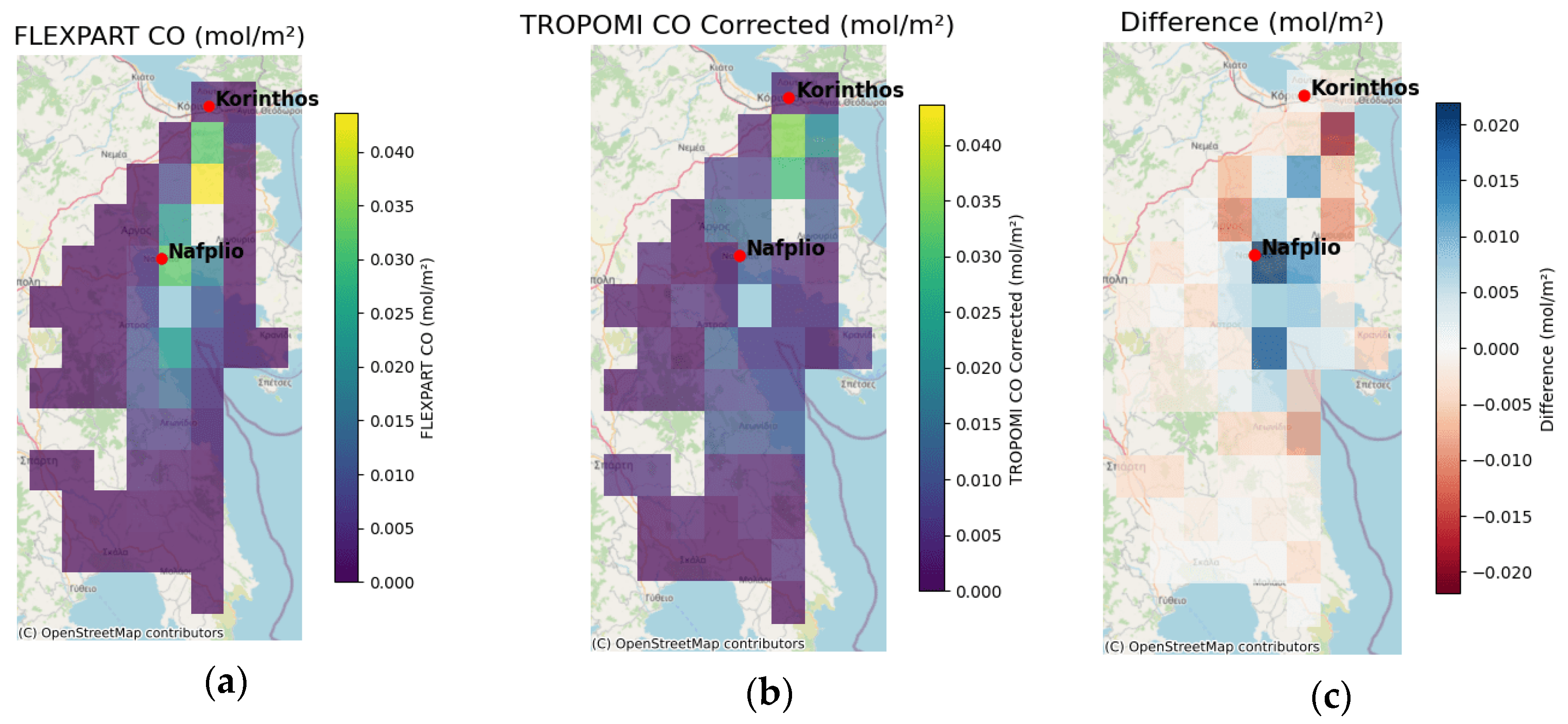
Figure 4 shows the same comparison with the WARM START configuration and hourly emissions. Comparatively the results of
Figure 3 and
Figure 4 are almost similar which is a reasonable conclusion since the current simulation stage is found very close to the beginning of the fire.
3.4. FLEXPART Simulation and Vertical Profile Comparison over Antikythera
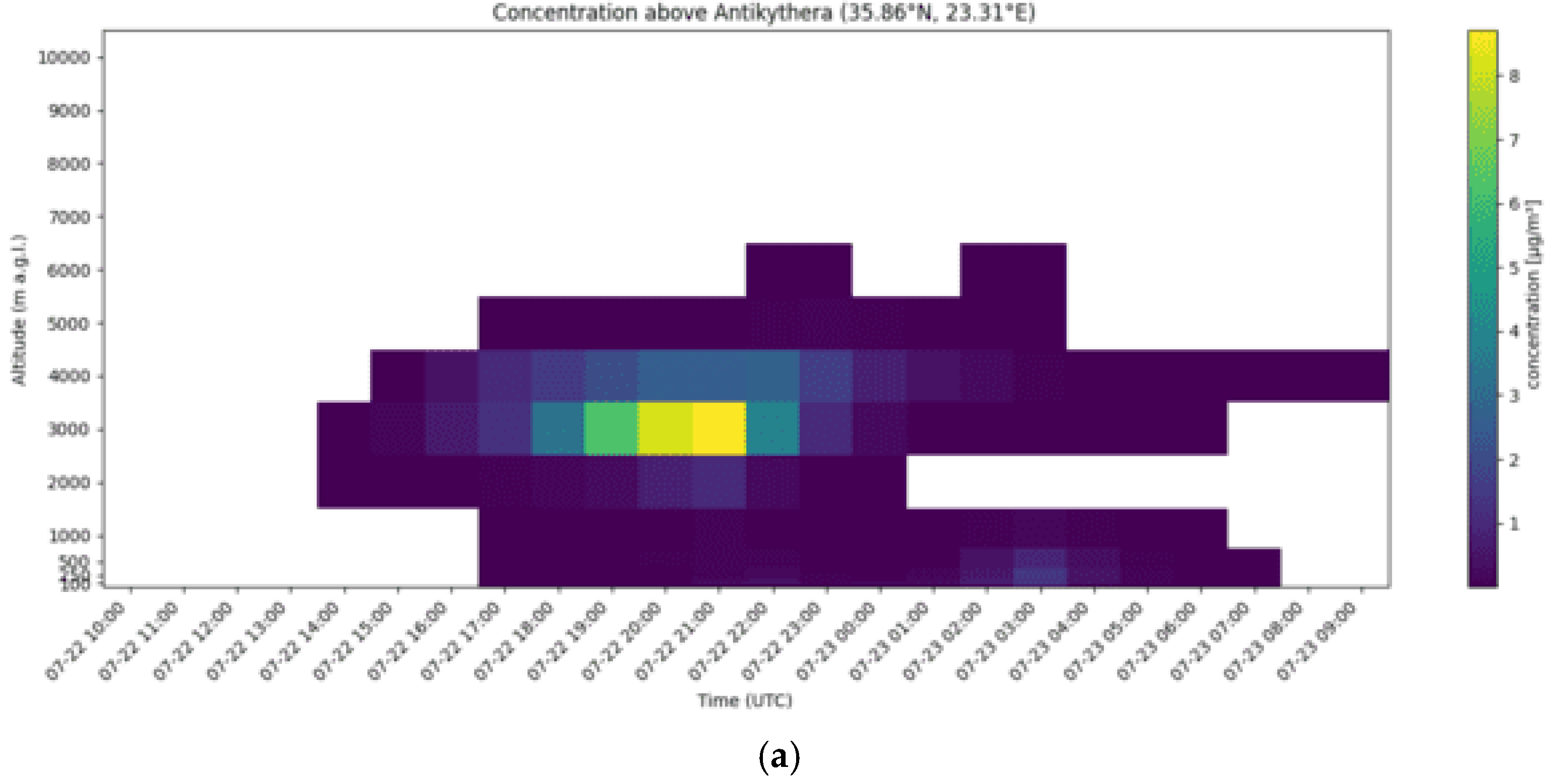
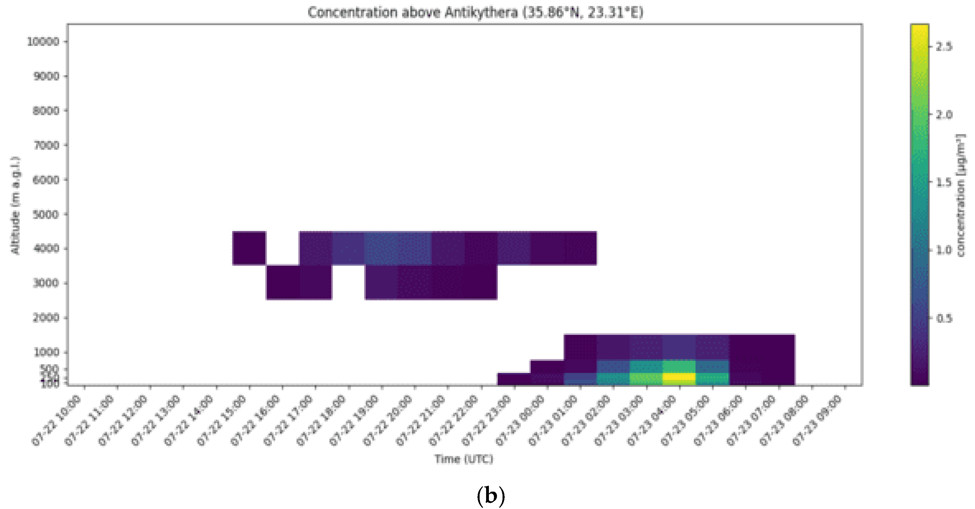
To evaluate the vertical distribution and timing of transported smoke from the Korinthos wildfire, FLEXPART simulation outputs were analyzed at the location of PANGEA-NOA (35.86° N, 23.31° E). Two simulations were compared: one using WARM START, which allows time- and location-sensitive particle release based on hourly emissions, and one using the standard configuration without WARM START. The simulated concentrations of TPM were then compared to the attenuated backscatter lidar signals from PANGEA.
Figure 5a shows the TPM concentrations from the WARM START simulation. A distinct aerosol layer appears between 2000 and 3000 m, starting around 14:00 UTC on 22 July, peaking near 21:00 UTC, and persisting until the early hours of 23 July. The vertical structure and intensity indicate a continuous and realistic depiction of lofted smoke as it traveled toward Antikythera.
In contrast,
Figure 5b displays the TPM output from the standard FLEXPART run without WARM START. Here, the plume is more fragmented and less intense, with peak concentrations appearing later in the transport cycle. The main elevated aerosol layer still develops below 3000 m but is less persistent and more limited in spatial coverage compared to the WARM START case.
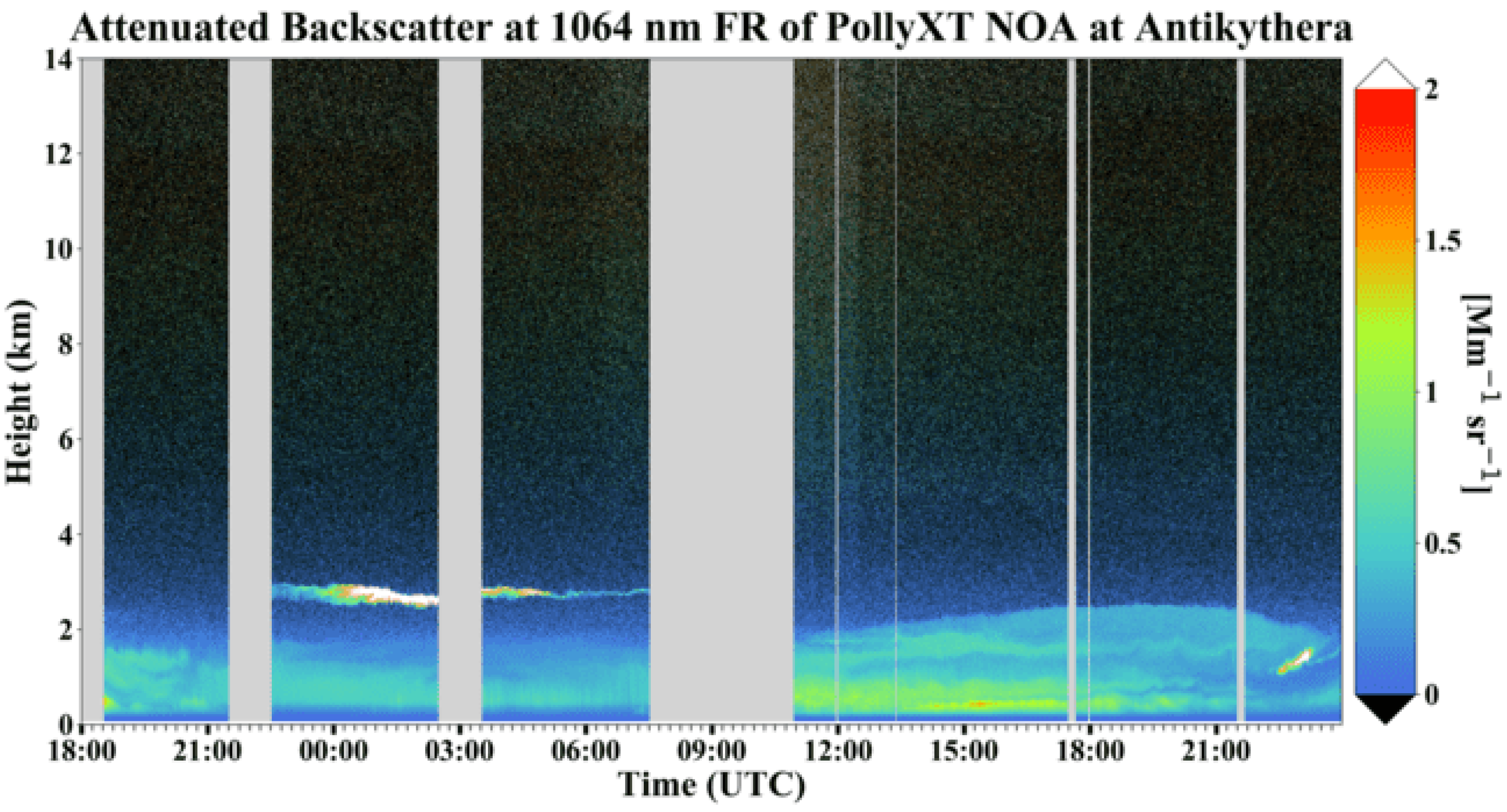
The lidar attenuated backscatter time–height plot on 22 July (
Figure 6 between 22:00 and 23:00 UTC) shows limited aerosol presence at heights between 2 and 3 km a.g.l, consistent with the early arrival of the smoke cloud. On 23 July (
Figure 6 between 00:00 and 06:00 UTC), a well-defined aerosol layer between 2 and 3 km is clearly visible (with peak extinction coefficient values around 700 Mm
−1 at 532 nm), consistent with the WARM START simulation both in terms of time and vertical extent. In contrast, the FLEXPART standard configuration simulation is not in good agreement with the lidar observations as it does not detect the smoke plume at 2–3 km altitude.
Overall, the WARM START FLEXPART configuration shows stronger agreement with the observed vertical structure of the smoke plume. The results highlight the importance of both high temporal resolution emission inputs and realistic injection timing/location for accurate long-range smoke transport simulations.
4. Discussion
This study applied a top-down method to estimate and model wildfire smoke emissions from the Korinthos fire in July 2020, using SEVIRI FRP data and the FLEXPART dispersion model. Hourly emission estimates were used to simulate smoke transport, with comparisons made to TROPOMI satellite observations, Sentinel-2 imagery, and lidar measurements from the PANGEA observatory. The WARM START configuration, which incorporated temporally and spatially resolved emissions, provided improved representation of plume timing and structure. These results highlight the importance of high-resolution emission data and realistic injection schemes for accurate wildfire smoke modeling.
Future research will focus on enhancing the accuracy and applicability of the current modeling framework. One key priority is to perform quantitative comparisons between FLEXPART-simulated TPM concentrations and ground-based measurements from the PANGEA-NOA station, allowing for the more straightforward and rigorous validation of the modeled outputs. Additionally, special attention will be given to the selection of smoke injection height, which plays a critical role in determining the vertical and horizontal distribution of the plume. Sensitivity experiments will be conducted to assess the impact of varying injection heights on simulated dispersion patterns. Furthermore, the influence of meteorological input data will be explored by running FLEXPART with alternative datasets such as ERA5 reanalysis and WRF model outputs, which may offer improved representation of local wind fields and boundary layer dynamics. These enhancements aim to refine the model’s performance in simulating wildfire smoke transport and to increase its reliability for real-time air quality forecasting and long-term atmospheric impact assessments.
Author Contributions
Conceptualization, T.K. and V.A.; methodology, T.K.; software, T.K.; validation, T.K., A.K. and A.G.; formal analysis, T.K.; investigation, T.K.; resources, V.A.; data curation, T.K.; writing—original draft preparation, T.K.; writing—review and editing, A.K., A.G., M.T., E.M., V.A. and I.K.; visualization, T.K., A.G. and M.T.; supervision, I.K. and V.A.; project administration, V.A.; funding acquisition, V.A. All authors have read and agreed to the published version of the manuscript.
Funding
This research was funded by PANORAMA project (Grant Agreement No. 101182795).
Institutional Review Board Statement
Not applicable.
Informed Consent Statement
Not applicable.
Data Availability Statement
The SEVIRI FRP data used in this study are publicly available from EUMETSAT LSA SAF. TROPOMI CO data are accessible from the Copernicus Open Access Hub. Lidar profiles from the PANGEA. FLEXPART model outputs generated during the study are available from the corresponding author on request.
Acknowledgments
T.K. and the authors affiliated to the National Observatory of Athens acknowledges the support by the following research projects: the PANORAMA project funded by the European Union (Grant Agreement 101182795); the PANGEA4CalVal project funded by the European Union (Grant Agreement 101079201); The ACTRIS Research Infrastructure; data and services obtained from the PANhellenic GEophysical Observatory of Antikythera (PANGEA) of NOA.
Conflicts of Interest
The authors declare no conflict of interest.
References
- Nguyen:, H.M.; Wooster, M.J. Advances in the estimation of high spatio-temporal resolution pan-African top-down biomass burning emissions made using geostationary fire radiative power (FRP) and MAIAC aerosol optical depth (AOD) data. Remote Sens. Environ. 2020, 248, 111971. [Google Scholar] [CrossRef]
- Yadav, I.C.; Devi, N.L. Biomass burning, regional air quality, and climate change. Encycl. Environ. Health 2019, 2, 386–391. [Google Scholar] [CrossRef]
- Mota, B.; Wooster, M.J. A new top-down approach for directly estimating biomass burning emissions and fuel consumption rates and totals from geostationary satellite fire radiative power (FRP). Remote Sens. Environ. 2018, 206, 45–62. [Google Scholar] [CrossRef]
- Koukouli, M.-E.; Pseftogkas, A.; Karagkiozidis, D.; Mermigkas, M.; Panou, T.; Balis, D.; Bais, A. Extreme wildfires over Northern Greece during Summer 2023—Part B. Adverse effects on regional air quality. Atmos. Res. 2025, 311, 108034. [Google Scholar] [CrossRef]
- Pisso, I.; Sollum, E.; Grythe, H.; Kristiansen, N.I.; Cassiani, M.; Eckhardt, S.; Arnold, D.; Morton, D.; Thompson, R.L.; Groot Zwaaftink, C.D.; et al. The Lagrangian particle dispersion model FLEXPART version 10.4. Geosci. Model Dev. 2019, 12, 4955–4997. [Google Scholar] [CrossRef]
- Solomos, S.; Amiridis, V.; Zanis, P.; Gerasopoulos, E.; Sofiou, F.I.; Herekakis, T.; Brioude, J.; Stohl, A.; Kahn, R.A.; Kontoes, C. Smoke dispersion modeling over complex terrain using high resolution meteorological data and satellite observations—The FireHub platform. Atmos. Environ. 2015, 119, 348–361. [Google Scholar] [CrossRef]
- Carter, T.S.; Heald, C.L.; Jimenez, J.L.; Campuzano-Jost, P.; Kondo, Y.; Moteki, N.; Schwarz, J.P.; Wiedinmyer, C.; Darmenov, A.S.; da Silva, A.M.; et al. How emissions uncertainty influences the distribution and radiative impacts of smoke from fires in North America. Atmos. Chem. Phys. Discuss. 2019, 2019, 1–50. [Google Scholar] [CrossRef]
| Disclaimer/Publisher’s Note: The statements, opinions and data contained in all publications are solely those of the individual author(s) and contributor(s) and not of MDPI and/or the editor(s). MDPI and/or the editor(s) disclaim responsibility for any injury to people or property resulting from any ideas, methods, instructions or products referred to in the content. |
© 2025 by the authors. Licensee MDPI, Basel, Switzerland. This article is an open access article distributed under the terms and conditions of the Creative Commons Attribution (CC BY) license (https://creativecommons.org/licenses/by/4.0/).

