
Evaluation of Surface Area Dynamics of Manta and Beleu Lakes †


Abstract
1. Introduction
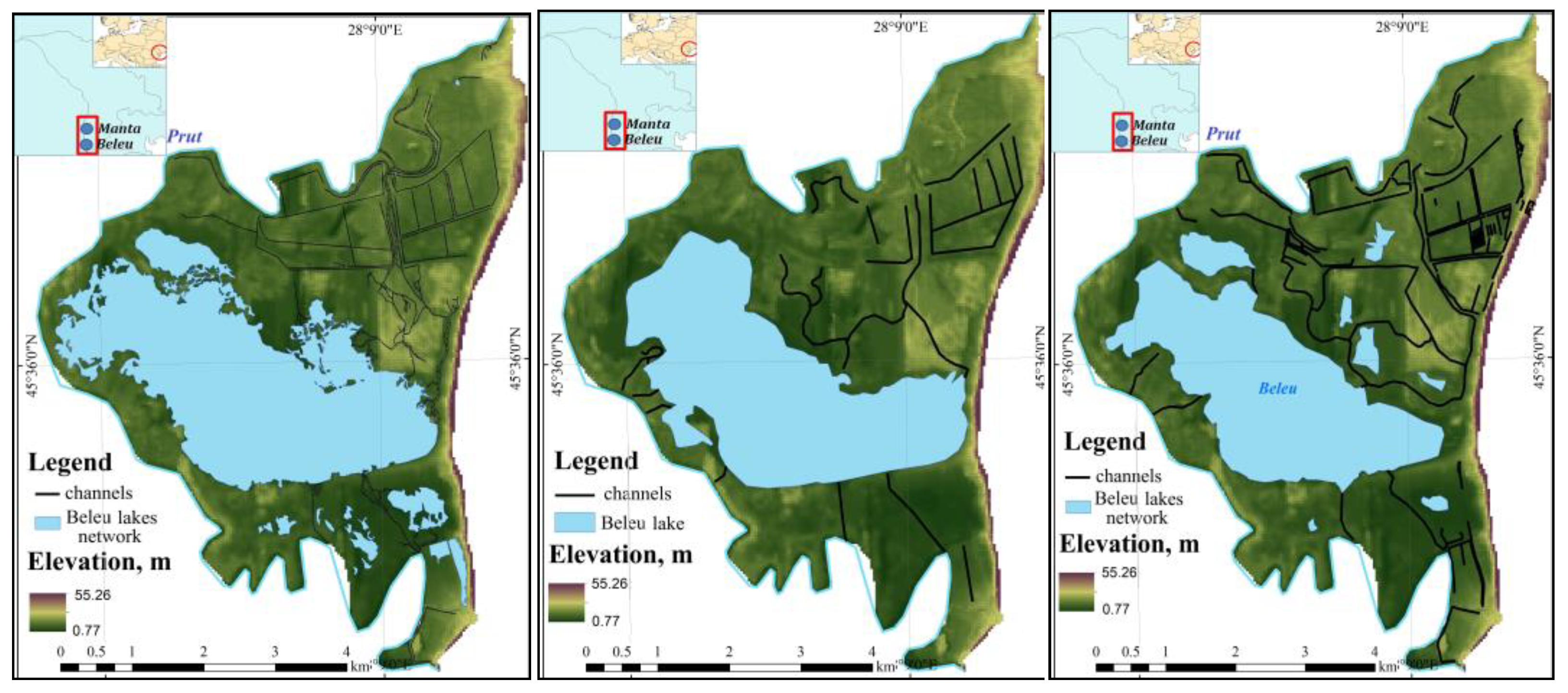
2. Study Area
3. Materials and Methods
4. Results and Discussions
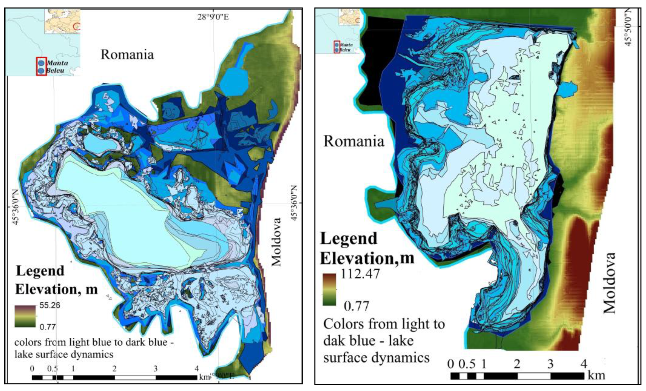
4.1. Dynamics in Surface Area Estimated Basing on Topographic Maps
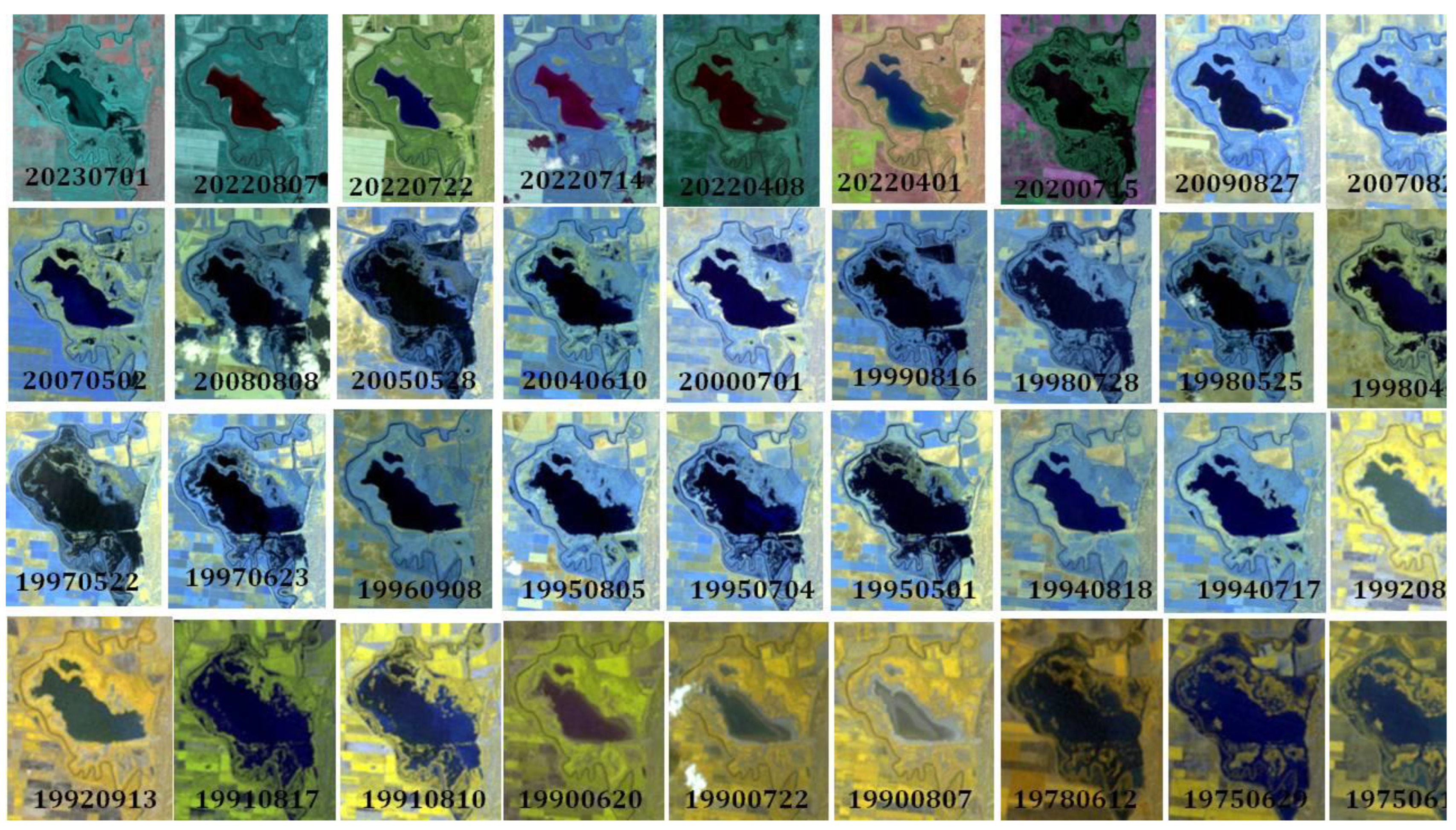
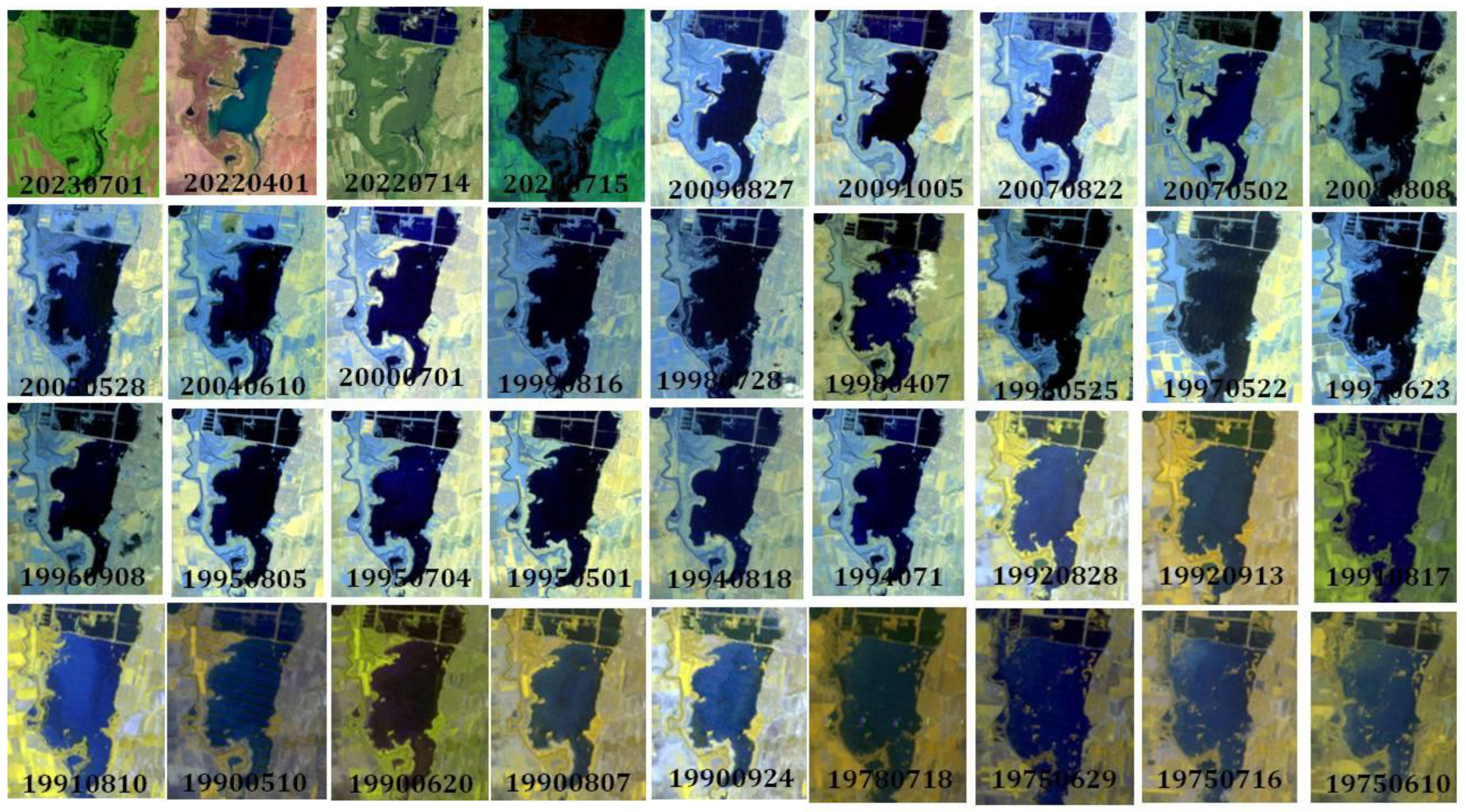
4.2. Dynamics in Surface Area Estimated Basing on Satellite Images
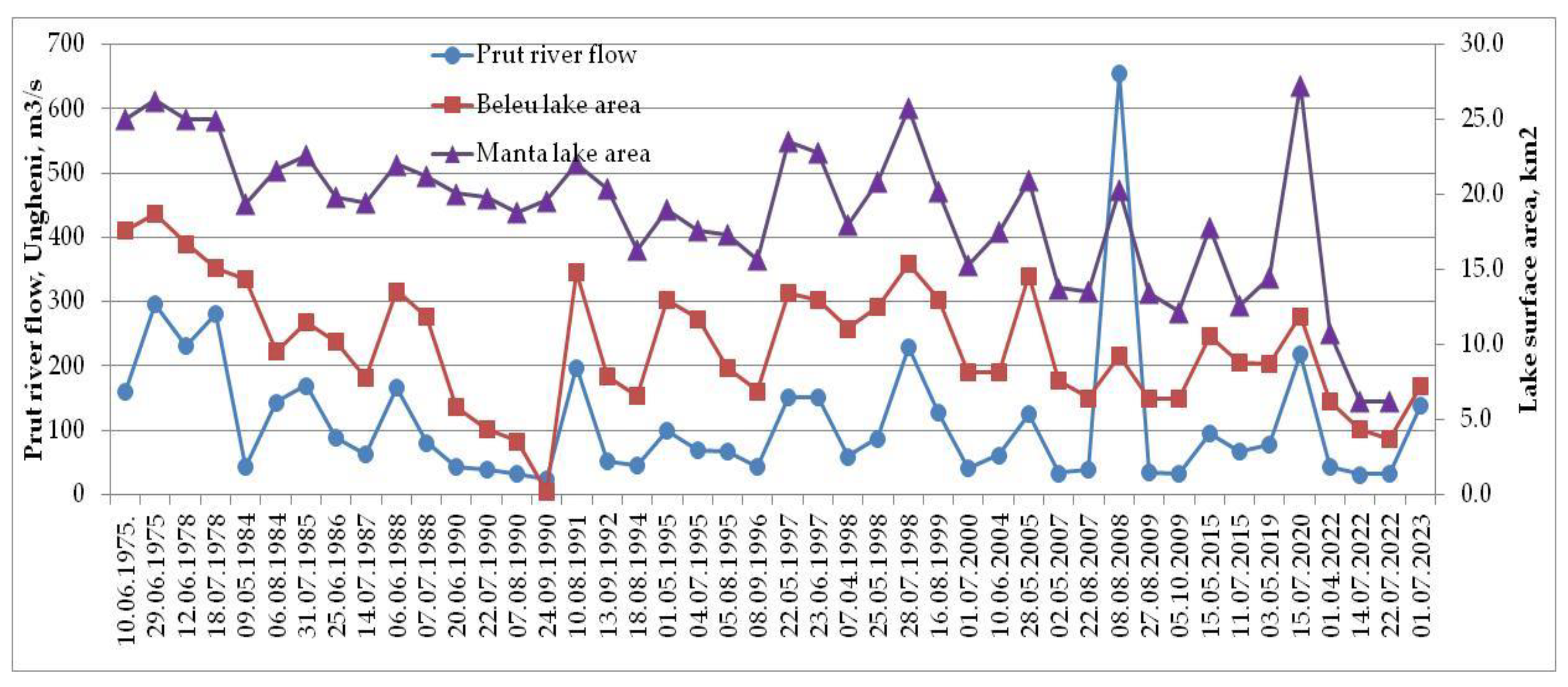
4.3. Relationships Between the Prut River Flow and Lakes’ Surface Area
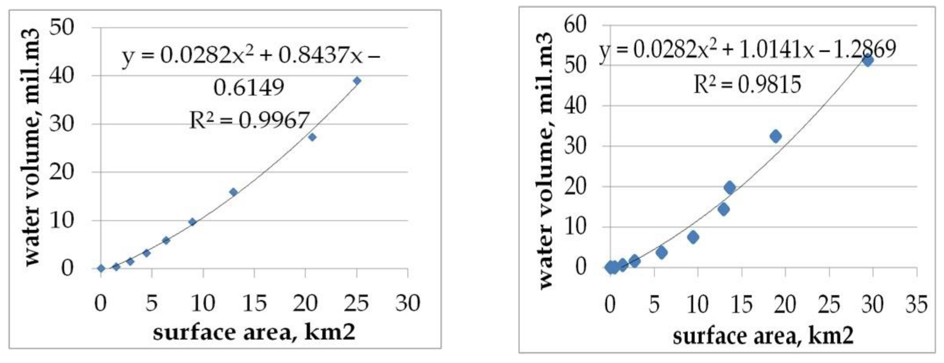
4.4. Relationships Between Lakes Surface Area and Volume
5. Conclusions
Funding
Institutional Review Board Statement
Informed Consent Statement
Data Availability Statement
Conflicts of Interest
References
- Hou, J.; Van Dijk, A.I.J.M.; Renzullo, L.J.; Larraondo, P.R. GloLakes: Water storage dynamics for 27,000 lakes globally from 1984 to present derived from satellite altimetry and optical imaging. Earth Syst. Sci. Data 2024, 16, 201–218. [Google Scholar] [CrossRef]
- Noges, T.; Noges, P.; Jolma, A.; Kaitaranta, J. Impacts of Climate Change on Physical Characteristics of Lakes in Europe; EUR 24064 EN; Office for Official Publications of the European Communities: Luxembourg, 2009; p. JRC54650. Available online: https://publications.jrc.ec.europa.eu/repository/handle/JRC54650 (accessed on 18 September 2024).
- Adrian, R.; O’Reilly, C.M.; Zagarese, H.; Baines, S.B.; Hessen, D.O.; Keller, W.; Livingstone, D.M.; Sommaruga, R.; Straile, D.; Van Donk, E.; et al. Lakes as sentinels of climate change. Limnol Oceanogr. 2009, 54, 2283–2297. Available online: https://pmc.ncbi.nlm.nih.gov/articles/PMC2854826/ (accessed on 16 September 2024).
- Vincent, W. Effects of Climate Change on Lakes. Encycl. Inland Waters 2009, 3, 55–60. Available online: https://www.academia.edu/30167457/Effects_of_Climate_Change_on_Lakes (accessed on 20 September 2024).
- Woolway, R.I.; Kraemer, B.M.; Lenters, J.D.; Merchant, C.J.; O’reilly, C.M.; Sharma, S. Global lake responses to climate change. Nat. Rev. Earth Environ. 2020, 1, 388–403. [Google Scholar] [CrossRef]
- Cazac, V.; Mihailescu, C.; Bejenaru, G.; Gilca, G. Water resources of the Republic of Moldova. In Surface Waters; Stiinta: Chisinau, Moldova, 2007; p. 248. (In Romanian) [Google Scholar]
- The Republic of Moldova Governmental Decision nr. 444 from 29-06-2022 Regarding the Approval of the Management Program of the Danube—Prut and Black Sea Basin District, Cycle II (2023–2028). Available online: https://www.legis.md/cautare/getResults?doc_id=132734&lang=ro (accessed on 17 September 2024). (In Romanian).
- The Republic of Moldova Governmental Decision nr. 70 from 19-02-2025 Regarding the Approval of the Dniester Basin District Management Plan, Cycle II (2025–2030). Available online: https://www.legis.md/cautare/getResults?doc_id=147587&lang=ro (accessed on 14 March 2025). (In Romanian).
- The Republic of Moldova Parliament Law Nr. 1538 from 25-02-1998 Regarding the Fund of Natural Areas Protected by State. Available online: https://www.legis.md/cautare/getResults?doc_id=141074&lang=ro# (accessed on 16 September 2024). (In Romanian).
- Biosphere Reserve Prutul de Jos. Available online: https://prutuldejos.md/despre-noi/ (accessed on 20 September 2024). (In Romanian).
- The Lower Dniester National Park. Available online: https://lower-dniester.org/aboutthearea (accessed on 2 September 2024). (In Romanian).
- The Natural Heritage of Core Areas of International Importance from the National Ecological Network of the Republic of Moldova: Illustrative Atlas. Available online: https://www.bioticamoldova.org/storage/files/Patrimoniul%20%20natural%20al%20zonelor%20nucleu%20REN.pdf (accessed on 22 September 2024). (In Romanian).
- Paladi, V. Ornithofauna of the “Lacurile Prutului de Jos” Ramsar Site. Ph.D. Thesis, Universitatea de Stat Din Moldova, Chisinau, Moldova, 2024; p. 182. Available online: https://www.anacec.md/files/Paladi-teza.pdf (accessed on 15 October 2024). (In Romanian).
- Paladi, V. Contribution to the study of water and semiaquatic birds in the Ramsar Wetland, Lower Prut Lakes. Sustainable use and protection of animal word in the context of climate change. In Proceedings of the X-Th International Conference of Zoologists, Chisinau, Moldova, 16–17 September 2021; pp. 348–357. [Google Scholar]
- Cojan, C.; Munteanu, A. Population dynamics and behavioral migration characteristics of aquatic and semi-aquatic birds from the Lower Prut basin. Bull. Acad. Sci. Life Sci. 2009, 3, 102–111. (In Romanian) [Google Scholar]
- Postolache, G.; Munteanu, A.; Postolache, D.; Cojan, C. Reserve “Prutul de Jos”; Tipografia Centrală: Chisinau, Moldova, 2012; p. 152. (In Romanian) [Google Scholar]
- Postolache, G. The integrated protected area of the Lower Prutul de Jos reserve. Mediu. Ambiant 2012, 2, 21–26. (In Romanian) [Google Scholar]
- Odainic, V.; Marin, I.; Cazacu, A.; Melnicenco, E. The Management Plan of the Frumoasa-Crihana Sub-Basin Cycle I (2021–2026); EcoContact, Centrul de Consultanţă Ecologică Cahul; Bons Offices SRL: Chişinău, Moldova, 2023; p. 132. (In Romanian) [Google Scholar]
- The Management Plan for the “Lower Dniester” Ramsar Zone, Approved by Minister’s Order no. 93 of December 1. 2014; p. 231. Available online: https://am.gov.md/sites/default/files/document/attachments/MAN-PLAN%20Nistru%20de%20Jos.pdf (accessed on 30 September 2024). (In Romanian)
- The Republic of Moldova Parliament Law Nr. 132 of 13-07-2018 Regarding the Establishment of the “Prutul de Jos” Biosphere Reserve. Published in Official Monitor Nr. 321–332 art. 515, on 24-08-2018. Available online: https://www.legis.md/cautare/getResults?doc_id=105493&lang=ro (accessed on 25 September 2024). (In Romanian).
- The Republic of Moldova Government Decision Nr. 122 from 12-08-2021 Regarding the approval of the Operating Regulations of the “Prutul de Jos” Biosphere Reserve. Available online: https://www.legis.md/cautare/getResults?doc_id=127440&lang=ro (accessed on 20 March 2025). (In Romanian).
- Jeleapov, A. The Study on Pluvial Floods in the Context of Human Impact on Environment; Tipografia Impressum: Chişinău, Moldova, 2020; p. 254. (In Romanian) [Google Scholar]
- Bulimaga, C.; Bacal, P.; Tugulea, A.; Certan, C. (Eds.) Complex Assessment of Urban and Rural Ecosystems in the Northern Development Region; Impressum: Chişinău, Moldova, 2023; p. 220. Available online: https://www.adrnord.md/public/files/2023WEBMonografie-Aprecierea-complexa-RD-Nord49e6e.pdf (accessed on 1 September 2024). (In Romanian)
- National Fund of Geospatial Data of the Republic of Moldova. Available online: https://geoportal.md (accessed on 2 May 2024).
- USGS. Earth Explorer, Landsat Images for 1975–2024. Available online: https://earthexplorer.usgs.gov/ (accessed on 2 May 2024).
- Quantum GIS. Available online: https://qgis.org/en/site/ (accessed on 12 January 2024).
- Li, Y.; Gong, X.; Guo, Z.; Xu, K.; Hu, D.; Zhou, H. An index and approach for water extraction using Landsat–OLI data. Int. J. Remote Sens. 2016, 37, 3611–3635. [Google Scholar] [CrossRef]
- Gao, B.-C. A Normalized Difference Water Index for Remote Sensing of Vegetation Liquid Water from Space. Remote Sens. Environ. 1996, 58, 257–266. [Google Scholar] [CrossRef]
- McFeeters, S.K. The Use of the Normalized Difference Water Index (NDWI) in the Delineation of Open Water Features. Int. J. Remote Sens. 1996, 17, 1425–1432. [Google Scholar] [CrossRef]
- Rogers, A.S.; Kearney, M.S. Reducing Signature Variability in Unmixing Coastal Marsh Thematic Mapper Scenes Using Spectral Indices. Int. J. Remote Sens. 2004, 25, 2317–2335. [Google Scholar] [CrossRef]
- Xu, H. A Study on Information Extraction of Water Body with the Modified Normalized Difference Water Index (MNDWI). J. Remote Sens. 2005, 9, 589–595. Available online: https://www.researchgate.net/publication/284418225_A_study_on_information_extraction_of_water_body_with_the_modified_normalized_difference_water_index_MNDWI (accessed on 16 July 2024).
- Hydrological Database of the Moldova State Hydrometeorological Service 2024.
- Hydrological Forecast. Available online: https://www.hidro.ro/bulletin_type/buletin-hidrologic-zilnic/ (accessed on 12 July 2024). (In Romanian).
- Hydrological Forecast. Hidrologic Bulletin. Available online: http://www.meteo.md/index.php/hidrologie/prognoze (accessed on 12 July 2024). (In Romanian).
- Hutchinson, G.E. A treatise on limnology. In Geography, Physics and Chemistry; Wiley: New York, NY, USA, 1957; Volume 1, p. 1015. [Google Scholar]


| Nr. | Index | Formula | Reference |
|---|---|---|---|
| 1 | NDWI | (BNIR − BSWIR)/(BNIR + BSWIR) | Gao 1995 [28] |
| 2 | NDWI | (BG − BNIR )/(BG + BNIR) | McFeeters 1996 [29] |
| 3 | NDWI | (BR − BSWIR)/(BR + BSWIR) | Rogers and Kearney 2004 [30] |
| 4 | MNDWI | (BG − BSWIR)/(BG + BSWIR) | Xu 2005 [31] |
Disclaimer/Publisher’s Note: The statements, opinions and data contained in all publications are solely those of the individual author(s) and contributor(s) and not of MDPI and/or the editor(s). MDPI and/or the editor(s) disclaim responsibility for any injury to people or property resulting from any ideas, methods, instructions or products referred to in the content. |
© 2025 by the author. Licensee MDPI, Basel, Switzerland. This article is an open access article distributed under the terms and conditions of the Creative Commons Attribution (CC BY) license (https://creativecommons.org/licenses/by/4.0/).
Share and Cite
Jeleapov, A. Evaluation of Surface Area Dynamics of Manta and Beleu Lakes. Environ. Earth Sci. Proc. 2025, 32, 19. https://doi.org/10.3390/eesp2025032019
Jeleapov A. Evaluation of Surface Area Dynamics of Manta and Beleu Lakes. Environmental and Earth Sciences Proceedings. 2025; 32(1):19. https://doi.org/10.3390/eesp2025032019
Chicago/Turabian StyleJeleapov, Ana. 2025. "Evaluation of Surface Area Dynamics of Manta and Beleu Lakes" Environmental and Earth Sciences Proceedings 32, no. 1: 19. https://doi.org/10.3390/eesp2025032019
APA StyleJeleapov, A. (2025). Evaluation of Surface Area Dynamics of Manta and Beleu Lakes. Environmental and Earth Sciences Proceedings, 32(1), 19. https://doi.org/10.3390/eesp2025032019