Article

The Identification and Diagnosis of ‘Hidden Ice’ in the Mountain Domain

Department of Geography, University of Sheffield, Sheffield S3 7ND, UK
Glacies 2025, 2(3), 8; https://doi.org/10.3390/glacies2030008 (registering DOI)
Submission received: 8 January 2025 / Revised: 29 April 2025 / Accepted: 4 July 2025 / Published: 15 July 2025

Abstract

Morphological problems for distinguishing between glacier ice, glacier ice with a debris cover (debris-covered glaciers), and rock glaciers are outlined with respect to recognising and mapping these features. Decimal latitude–longitude [dLL] values are used for geolocation. One model for rock glacier formation and flow discusses the idea that they consist of ‘mountain permafrost’. However, signs of permafrost-derived ice, such as flow features, have not been identified in these landsystems; talus slopes in the neighbourhoods of glaciers and rock glaciers. An alternative view, whereby rock glaciers are derived from glacier ice rather than permafrost, is demonstrated with examples from various locations in the mountain domain, 𝔻𝕞. A Google Earth and field examination of many rock glaciers shows glacier ice exposed below a rock debris mantle. Ice exposure sites provide ground truth for observations and interpretations stating that rock glaciers are indeed formed from glacier ice. Exposure sites include bare ice at the headwalls of cirques and above debris-covered glaciers; additionally, ice cliffs on the sides of meltwater pools are visible at various locations along the lengths of rock glaciers. Inspection using Google Earth shows that these pools can be traced downslope and their sizes can be monitored between images. Meltwater pools occur in rock glaciers that have been previously identified in inventories as being indictive of permafrost in the mountain domain. Glaciers with a thick rock debris cover exhibit ‘hidden ice’ and are shown to be geomorphological units mapped as rock glaciers.

1. Introduction

Glaciers have long been recognised as important water reservoirs (or ‘Water Towers’) and resources in the mountain domain, 𝔻𝕞. As such, glacier ice bodies and the snowfields that feed them have provided water storage for hydro-electric schemes in the Alps, North America, and Scandinavia. In remote mountain communities, glaciers and snowpacks provide irrigation and potable water, especially to the increasingly large urban areas in the vicinity of mountains [1]. The depletion of these glacier bodies has been recognised to be associated with ‘global heating’ and glacier snout ‘retreat’, which have been observed in paleoenvironmental records [2]. Rapid glacier recession, especially in the last 40 years [3], has followed a general retreat since the Little Ice Age (LIA) maximum extent, which was documented particularly by Grove [4], who provided a variety of evidence for LIA glacier extents, particularly in the form of images and cartographic evidence. Although various times have been suggested for the beginning of this retreat from an LIA maximum, 1900 is often taken as an approximate global time. From about then, topographic maps (showing glacier extents) were becoming more precise and frequent updating surveys were conducted, even in remote areas such as the Karakorum [5]. Therefore, it has become important to map and evaluate these global mountain water resources.

2. Glacier Mapping

Although the glacier mapping of individual glaciers and glacier systems has taken place (and recorded in the volumes just cited), it was not until 1965 that there was a symposium on glacier mapping, which was held in Ottawa [6]; the second symposium was held in Reykjavik [7]. Although satellites and remote sensing techniques from aircraft, such as ‘radio-echo sounding’, were employed for the largest ice masses (Antarctica, Greenland, and Iceland), ‘traditional’ methods such as aerial (aircraft) imagery and photogrammetry coupled with terrestrial mapping were widely used. Not only were there practical difficulties involved, such as the identification of points on uniform snowfields, which were solved by Kasser and Röthlisberger [8] via ‘bombing’ surfaces with paper bags filled with soot, but the delimitation of ice limits and tracking glaciers under debris, as well as the extent of stagnant glacier ice, also presented problems. Even in recent developments in high-resolution satellite imagery, with improved ice radars and LiDAR techniques, some of these problems continue to exist, particularly as small glaciers disappear below ‘detectable’ or ‘glaciologically viable’ extents [9]. This extent has been stated to be <0.1 km2, which is loosely tied to the area that can sustain an ice thickness of about 30 m, at which the body can flow under its self-weight.
The Global Land Ice Measurements from Space (GLIMS) project [10] and the associated Randolph Glacier Inventory (RGI) [11] have used historic and present-day mapping to record glacier locations and areas within a cartographic framework. The GLIMS definition of a glacier is as follows:
A glacier or perennial snow mass, identified by a single GLIMS glacier ID, consists of a body of ice and snow that is observed at the end of the melt season, or, in the case of tropical glaciers, after transient snow melts. This includes, at a minimum, all tributaries and connected feeders that contribute ice to the main glacier, plus all debris­covered parts of it. Excluded is all exposed ground, including nunataks. An ice shelf … shall be considered as a separate glacier.
([12], p. 4)
Some of these difficulties in observation, mapping, and recording can be seen in Figure 1. This shows small glacier extents being covered by debris on the slopes of Red Mountain in Sierra Nevada, CA, as noted by Millar and Westfall [13]; for further discussion, please refer to [14]. The decimal latitude–longitude [dLL] geolocation (to four decimals) of Red Mountain is [37.5074,-18.8690]. A similar situation of glacier disappearance and designation in the RGI is presented in the work of Whalley [15] in relation to the Spanish Pyrenees.

3. Debris-Covered Glaciers and Rock Glaciers

As indicated by Whalley et al. [16], glacier inventories have sometimes included the identification of rock glaciers (RG) as ‘hidden ice’ in glacier surveys [17]. In the UNESCO guide for a world inventory of perennial snow and ice masses, Müller et al. [18] proposed that rock glaciers should be included in glacier inventories, as follows:
A glacier-shaped mass of angular rock either with interstitial ice, firn and snow or covering the remnants of a glacier, moving slowly downslope. If in doubt about the ice content, the frequently present surface firn fields should be classified as ‘Glacieret and snowfield’.
Whalley et al. [16] suggested that morphological criteria can aid in the identification of rock glaciers, using terrestrial surveys or aerial photographs, as follows:
  • They are found in mountainous regions that have, or have had, glacial/’periglacial’ conditions.
  • They have the outward appearance of being composed of rock debris.
  • They show the extent of this rock debris as distinct limits, both marginally and terminally (but less distinctly at their heads).
  • They have a debris source area (or areas), i.e., a head and, in addition, a distinct snout, which marks their maximum extent down-slope.
  • They have, in many cases, flow-like features on their surfaces. The rock glacier is supposed to flow (or have) flowed, in the case of relict features, as a result of ice contained in some manner within the rock debris.
These are morphological distinctions, but it is widely accepted that the flow (creep) rates are low, generally 1 m/a or less. These low surface velocities have been known for many years [19] and have been incorporated into some definitions of rock glaciers. However, Raup and Khalsa [12] indicate that rock glaciers and heavily debris­covered glaciers that tend to look similar, but their origins are different. GLIMS does not currently deal with the former but does include the latter.
The global survey of glaciers with debris cover ([20], p. 373) make little of rock glacier presence, mainly concentrating on large–long glacier systems such as the Langtang Himal, Nepal, where the “Thick debris cover on glaciers can significantly reduce ice melt. However, several studies have suggested that debris-covered glaciers in the Himalaya might have lost mass at a rate similar to debris-free glaciers”.
Conversely, Harrison et al. [21] looked at rock glaciers across the Himalaya and the transition from mountain glacier to rock glacier [22], where rock glaciers represent ‘hidden water stores’ in the Himalaya [23]—returning us to points made in the Introduction, above, as in a review [24].
The International Permafrost Association (IPA) Action Group and Rock Glacier Inventories and Kinematics (RGIK) [25] intend to standardise, via guidelines, the making of inventories. The motivations for identifying rock glaciers and making inventories are, in brief, as follows:
Geomorphological mapping [26];
Proxies for permafrost occurrence [27];
Paleo-permafrost studies [28];
Climate-relevant variables [29];
Hydrological significance—again, this is important for water storage in mountain basins as in papers cited above, as well as the work of Abdullah and Romshoo [30];
Geohazards [31,32].
Many recent papers relating to identifying, mapping, and making inventories of rock glaciers make claims about their significance, as in the papers just listed. At the time of the review by Martin and Whalley [33], citations were almost entirely in geological, geomorphological, and geographical journals, amounting to a few per year. Since 2020, the number of papers dealing with rock glaciers has increased markedly and the range of journals extended to include Remote Sensing, Digital Earth, Computer Science, Science of the Total Environment, and more recently established earth science journals such as The Cryosphere, EGU Sphere, and Global and Planetary Change. Thus, how authors define and interpret rock glaciers and their presence in an area is important.

4. Rock Glacier Definitions

A commonly used definition, using mainly morphology, is as follows:
‘Rock glaciers are characteristic landforms associated with mountain periglacial landscapes. They are prevalent periglacial items of the Earth’s geomorphological heritage, whose identification (detection and delineation) can be nevertheless challenging’.
([25], p. 4)
Adding the following, we determine that:
‘Rock glaciers are identified and mapped as functional or inherited (relict) landforms of the geomorphological landscape: they are part of the mountain sediment cascade and as such contribute to control the pace of periglacial mountain landscape evolution’
([25], p. 5)
The definition used by RGIK [25] is essentially morphological and can be identified by the five distinctions listed previously from the work of Whalley et al. [16]. However, these definitions do not say what RG ‘are’, noting that ‘There is a difference between the name of the thing and what goes on.’ ([34], p. 865).
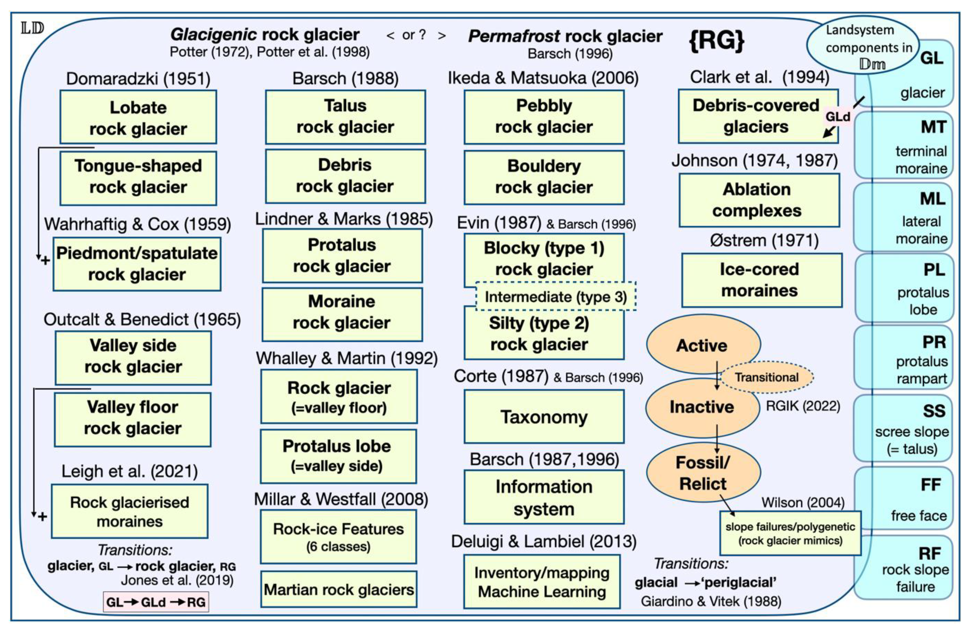
Just as different species of bird may look similar, ‘blackbirds’ may be in different families but are still in the Aves class. Unfortunately, RG come in all sorts of different shapes and sizes and, indeed, each is unique; classifications are loose and variable (Figure 2). But there has been a tendency to lump all RG forms under the same heading for paper content and implications. The label RG designates a mappable entity, currently seen in satellite photography, in a similar manner as to GL (glaciers) and GLd (debris-covered glaciers). The above-mentioned ‘GLIMS problem’ can be used to distinguish these. The information container {RG} indicates any collection of properties associated with a landform named as an RG that can be geolocated at a given [dLL]. For an explanation of a feature, the material properties (M) and the processes involved (P) need to be added to the geometric features, G, (such as plan form, edge demarcation, and surface features such as ridges and furrows on RG). This is a general problem for interpreting any landform entity and not just defining it. The difficulties in defining several landforms associated with ‘periglacial’ landscapes relate to the fact that they may have origins in non-periglacial areas extending over hundreds of thousands of years [35]. Some landforms may develop rapidly and perhaps be seen on passes of satellites; therefore, as observations have a place and a time, it may be appropriate to designate a date together with a geolocated feature. In the data presented below, this is often carried out with @year appended to a [dLL].
There are genetic, i.e., species, distinctions that separate the new-world blackbird family (Icteridae) from old-world blackbirds (Turdidae). The behaviour of a recognised landform may require investigations of its material and mechanical properties to determine its genetic origin and formation.
The distinction for RG (Figure 2—top line) is that they are either the result of glacier surfaces being buried by surficial debris, and thus contain glacier ice, or that the ice is from the ‘permafrost’ accretion of ice and has nothing to do with glaciers. A substantial aspect of the ‘what are RG?’ hinges around the evidence for one, or perhaps both, of these notional genetic models. They may be briefly demarcated as the glacier-derived or ‘glacigenic’ model, where the ice is sedimentary or where the ice has accreted within a rock debris mass under permafrost conditions as a ‘cryo-conditioned’ material [57] relating to ‘permafrost rock glaciers’ [58].
There has long been debate about these models [19,33,37]. The work of Potter et al. [51], as well as the original work of Potter [52], shows the Galena Creek RG[44.6503,-109.7912] has a glacier ice core; this has been disputed by Barsch [36,59], who proposes that RG can only have a cryogenic (permafrost) origin and never have glacier ice cores. Although some recent statements, such as those using RG for permafrost mapping [60], only offer a permafrost viewpoint, others suggest mixed [61] or transitional possibilities [21,62].
The definition used by RGIK [25,53] is ‘glacier exclusive’, i.e., there is no room for either glaciers (GL) or debris-covered glaciers (GLd) in the formation of rock glaciers (RG). This is also related to the ‘GLIMS demarcation problem’. A corollary is that any inventory of mapped RG cannot include any feature shown to have a glacier ice core or be a GLd, as this would be a category error. However, the recent publication by Kääb and Røste [63] and Hu et al. [64], although not immediately apparent, do make this error. Kääb and Røste [63—Figure 1] map the ‘changes in rock glacier surface speed’ over the western United States. Although named, not one rock glacier is shown or given a geolocation to provide a ground truth for checking. Galena Creek is indicated, although Galena Creek RG[44.6503,-109.7912], as above, does have a glacier ice core and is thus has its origins as a debris-covered glacier. This is shown with imagery and geophysics by Meng et al. [65]. The Arapaho RG[40.0235,-105.6379] has long been known as having a glacier ice core [50]. The authors of Ref [64] promote ‘rock glacier velocity’ as an essential climatic variable (ECV), citing that ‘Rock glaciers are debris landforms that constitute an integral part of the mid- and high-latitude mountain’. A citation given to support this statement is that by Clark et al. [66], although they support a glacier ice core–debris-covered glacier origin for Galena Creek RG. Furthermore, Table 2 in the study of Hu et al. [64], entitled ‘A Selection of Research Milestones (Until 2023) in the Studies of Rock Glacier Kinematics’, does not include example ‘milestones’ that have shown glacier ice cores or are ‘glacier-connected’ rock glaciers. Examples are included in the work of Potter et al. [51], Whalley and Palmer [67], and Konrad et al. [68]. In the remainder of this review, I show, with ground-truth examples, that there are many examples of glacier ice, glacier ice-cored moraines, and debris-covered glaciers being associated with rock glaciers, which themselves have clear evidence of glacier ice below a debris cover. Further examples are now available regarding South American rock glaciers [69].

5. Survey and Mapping Methods and the Need for a ‘Ground Truth’

The recent paper by Wee et al. ([70], p. 5940) rightly suggest that RG and their associated landforms present the following:
The post-glacial dynamics of these systems and their associated landforms comprise spatio-temporally complex and interlaced glacial, periglacial, paraglacial, hydrological, and mass-wasting processes, whose full understanding requires high-resolution, quantitative, multi-method, and interdisciplinary approaches.
Unfortunately, the naming of processes or areas (such as ‘periglacial’, ‘paraglacial’, ‘transitional’ or even ‘glacial’) is vague [56] and we need to be much more specific in recognising the locations of features and differentiating landforms (Figure 2), as well as genetics. For this, some ‘ground truth’ is required in order to validate the interpretations given by interdisciplinary approaches. The following sections show examples where glacier ice cores are exposed under RG debris covers to confirm or deny the ‘hidden ice’ in RG [16].

6. Epidemiology of Glacier Ice Cores in Rock Glaciers

The approach taken here is to bring together some observations of what are believed to be glacier ice exposures in RG with illustrations and, as far as possible, geolocations. We may view these exposures as occurrences, or blemishes, on the surface of the earth, which are mapped as RG. Although not a meta survey, the examples help in starting to examine features as one would an epidemiological survey such as that for the skin [71]. With features identified in space and time, the progression of the epidemic can be plotted for significance and causality. There has been an epidemic of observations of glacier ice exposures over the last few years. Google Earth images, especially with improved resolution and coverage over time, show how, where, and when the ice exposures occur. GE images coupled to earlier investigations, whether cartographic, terrestrial, or satellite, are especially useful, while geolocation, as with the following examples, shows how these can be tracked for future analysis. Surface meltwater pools and their growth in numbers, size, and velocity do show characteristics of an epidemic.

6.1. Glaciers with Thin Debris Covers

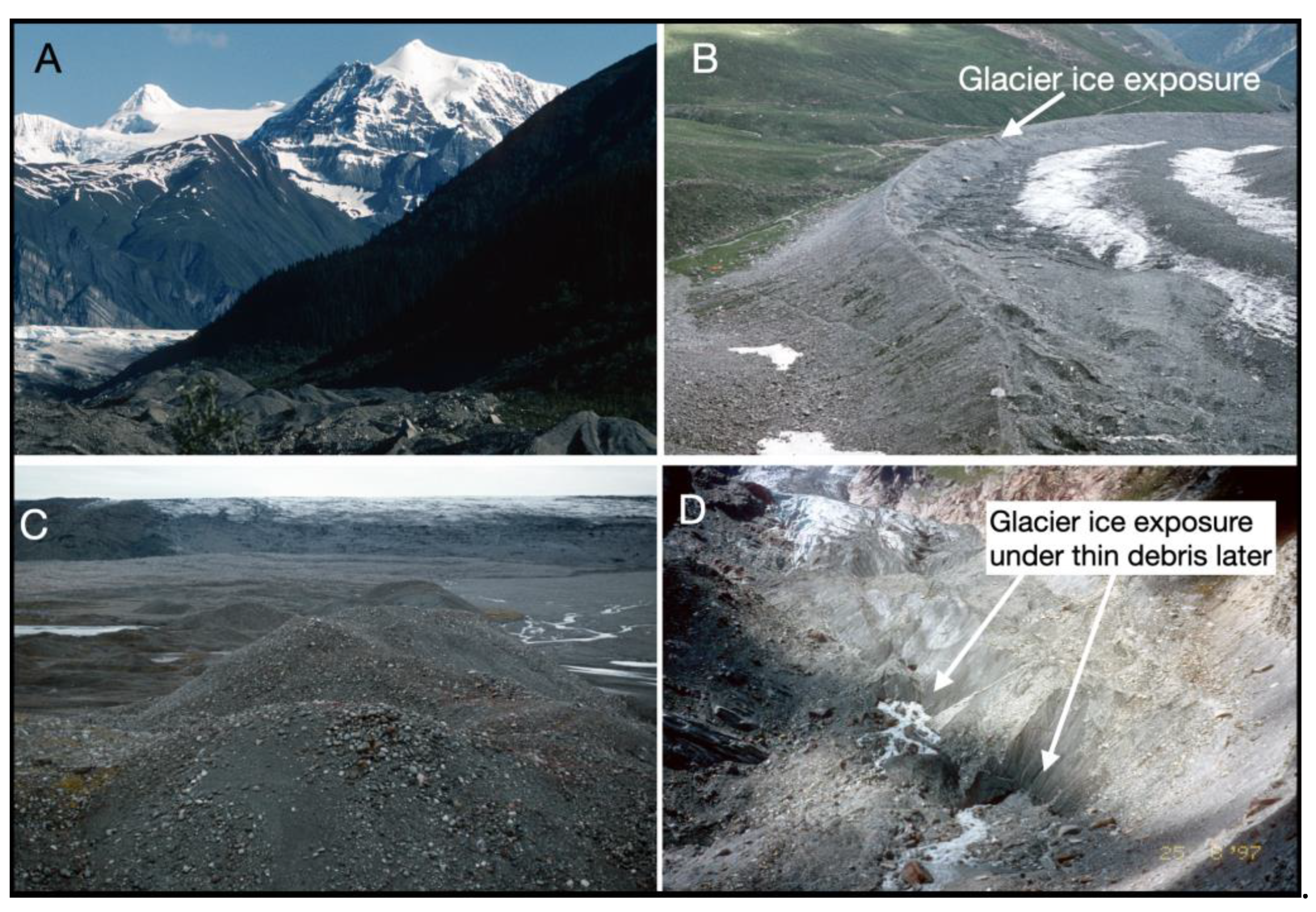
Figure 3 shows the debris covers associated with large valley glaciers where the ice can be seen under thin debris covers of a few cm thickness. The figure caption gives details and locations as [dLL].

6.2. Classic Rock Glaciers in the Wrangell Mountains, Alaska

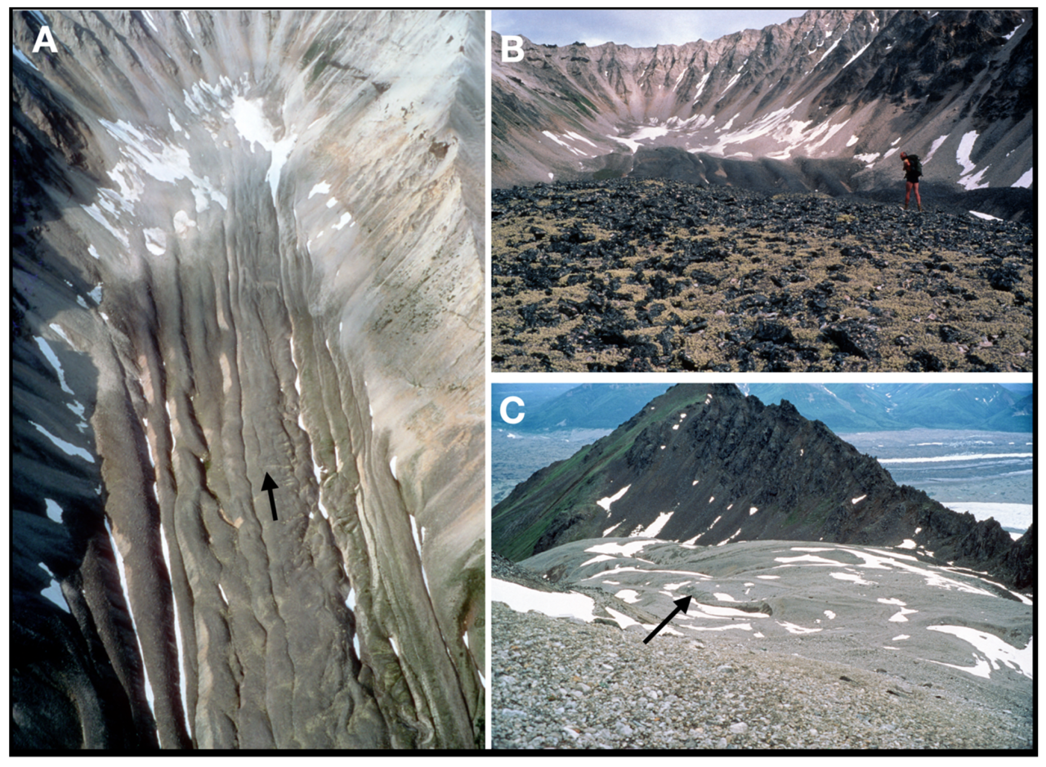
These images are typical of debris on visible, active glaciers and can be compared with the RG shown in Figure 4. This is the National Creek RG, with its complex active snout at [61.4868,-142.8693]; it is described as “rock glacier 2” with maps and images in the work of Capps [74], as can be seen in Figure 3 from his fieldwork in 1909. The images in Figure 4 are from 1987. It is easy to see why Capps called such features rock glaciers, with the following being stated:
The rock glaciers in form and position resemble true glaciers in noticeable ways. They head in cirques and extend from these down the valley, in cross-section being highest above the valley axis and sloping down sharply on the sides. Some were seen to have distinct lateral moraine-like ridges, and all show a more or less well-marked longitudinal ridging ([74], p. 362).
Although Capps considered rock glaciers as ‘the true successors of real glaciers’ and with, ‘all stages varying from apparently active glaciers with short rock glaciers below to rock glaciers in which no glacier ice is seen’, he believed them to be the result of interstitial ice formation. Nevertheless, he states that ‘Nowhere have the talus slopes at the heads of the cirques been able to form any considerable accumulations on the surface of the rock glaciers. This seems to be very strong evidence that the talus has moved on down the valley as fast as it has been supplied.’ ([74], p. 372).
With reference to Figure 4, the main attributes described by Capps [74] can be confirmed. In particular, the formation of the longitudinal ridges by continuous talus accretion over a glacier surface are confirmed. Glacier transport is indicated because flowlines are indicated by the longitudinal ridges and furrows from the cirque-head. Lateral ridges have origins in small talus cones, and the feature has not formed from independent ice accretion in these cones. We also know that ice–rock mixtures do not flow [75,76] and that any underlying body of ice needs to be at least 20 m thick [77]. The debris supply must have kept pace with glacier ice flow, removing the surface debris. As of yet, no glacier ice has been exposed at the head of this RG, nor for others in the region.
The general model of glacier-ice-cored RG requires only that rock debris (e.g., scree and talus) is formed on the cliffs above, deposited on or near the ice surface, and is transported away, as with a ‘normal’ glacier (Figure 3). The preservation of glacier ice occurs when the debris supplied becomes sufficiently thick to cover the ice and preserve it from melting. If the glacier is steep and thick, then surface debris will be removed to the snout or sides or will be deposited as lateral moraines (Figure 3). The large glacier–rock glacier systems in the Himalaya are indeed ‘transitional’ [46] in this sense; from essentially debris-free glacier surfaces (GL), through GLd to RG. The rock glacier–glacier systems described by Whalley [78] in the Hindu Kush are well below any permafrost altitudinal limit and glacier ice can be traced through these systems, corresponding to varying amounts of ice and debris in each valley. The ice mass continuity is important and indeed vital for rock glacier formation.

6.3. Stranded Glacier Ice and Rock Glaciers

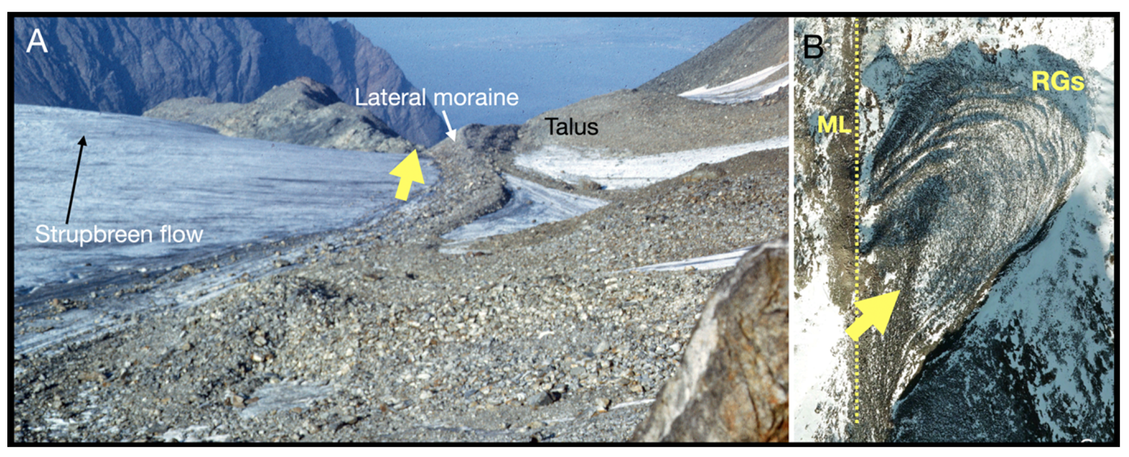
The effect of talus supply to glacier margins to form small RG has been reported elsewhere, such as in Lyngen, North Norway, on the margin of Strupbreen [69.7029, 20.2082] [79], as shown in Figure 5. Larsbreen in Svalbard [78.1931,15.5916] [80] is another example. While the classic Wrangell Mountains area described by Capps has long-axis, tongue-shaped, rock glaciers in an area of permafrost which head into cirques, there are no valley-side or lobate [50] RG formed from talus slopes.
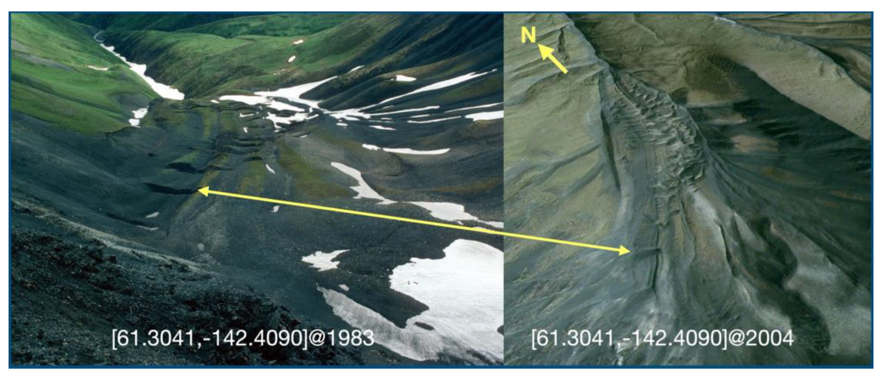
The small RG shown in Figure 6 in the Wrangell Mountains shows crevasses in the 1983 image covered with debris, which have become more rounded and open with melting in the intervening 20 years. In this case, the RG was formed by debris covering a glacier that has spilled over the col to the south at [61.2981,-142.4181] from the much larger Rex Glacier down-wasting from its LIA maximum.
The RG from the right lateral of the Weissmies glacier ML [46.1412,8.0352] described by Messerli and Zurbuchen [81] and attributed to a permafrost origin is very similar to that at Strupbreen (Figure 5B).

6.4. Classic Sites: Galena Creek RG and Gruben RG

These two sites have a considerable legacy in relation to their investigation and reporting that will not be repeated here. It will have to suffice to show that, contra Barsch [59] for Galena Creek RG and Haeberli [82] for Gruben RG, glacier ice does indeed exist, as shown in Figure 7.
Although disputed, the fact that glacier ice can and does exist under thin debris coverings to preserve the ice is clearly shown in Figure 7 and in associated references.

6.5. Ice Exposure at and Near Cirque Headwalls

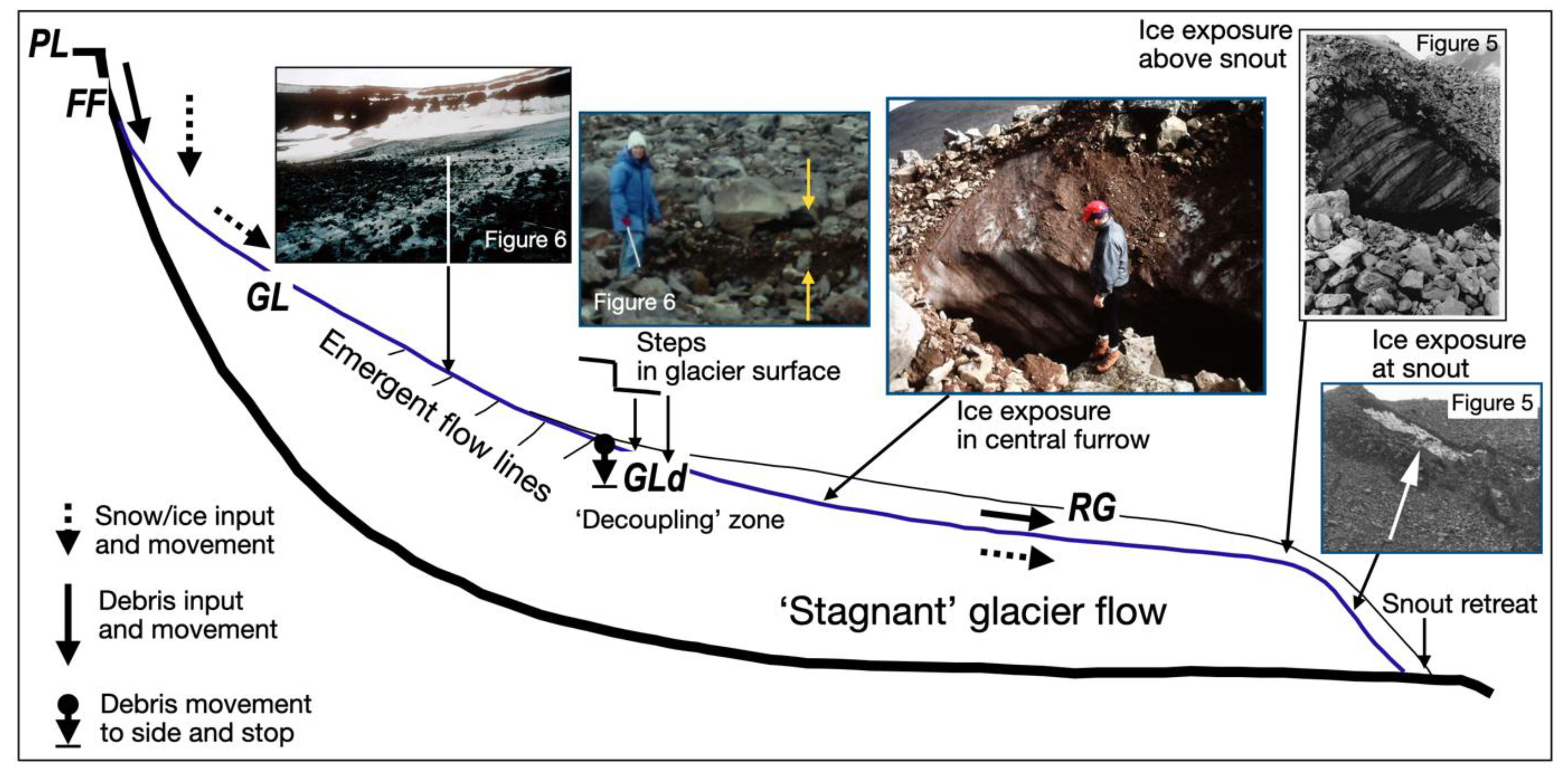
Although clear evidence of glacier ice on RG in the Wrangell mountains (Figure 4) has yet to be shown, there are clear examples in the literature. The well-studied Nautardalur RG and landsystem [84] in Iceland [65.4910,-18.3692] has a small glacier at its head and an RG developed below. Figure 8 is a summary diagram showing the glacier ice continuity coupled with debris transport though the system. In the same paper, Whalley [84] also shows the importance of the cirque size for both snow/glacier collection and debris accumulation. In this case, the GL system was enhanced by the debris cover, allowing it to exist without substantial melting. This is considered to be post-LIA formation.
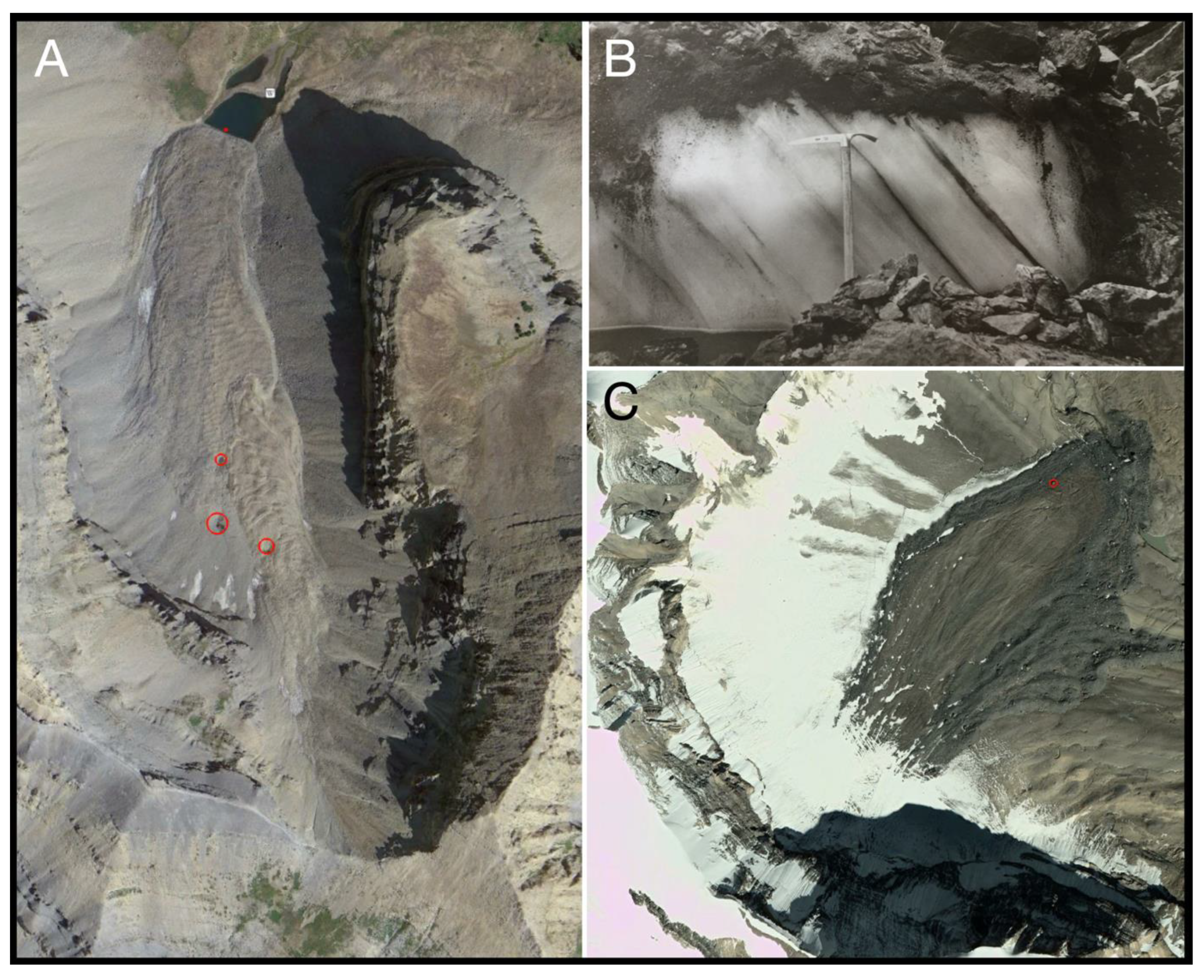
Although not fully documented and investigated, the Timpanogos RG[40.3922,-111.6405] (Figure 9) in Utah [85] appears to have been formed very rapidly by the burial of a small glacier from rockfall in the last 100 years [86]. The authors of [87] give evidence showing that glacier ice exposures can be found on the Timpanagos RG. However, the Gad Valley RG[40.5569,-111.6590] in Little Cottonwood Canyon has multiple longitudinal furrows but no obvious ice exposures or meltwater pools. Similarly, in the high 𝔻𝕞 of the Colorado Rockies, Outcalt and Benedict [50] reported a glacier ice core in the Arapaho RG[40.0235,-105.6379] (Figure 9B). Debris transport paths in the associated Arapaho GL have been reported by Reheis [88].
Small rock glaciers have also started to form subsequent to the re-establishment of a glacier within the crater of Mt St Helens [89]—Loowit Glacier GLd[46.2135,-122.1854] and Leschi glacier RG[46.2078,-122.1832]. In time, it will be interesting to monitor the formation of rock glaciers where substantial rockfalls have covered parts of the glaciers [89] (see Figure 9C). Deline et al. [90] in a brief mention of ‘reduced ablation due to rock avalanche deposits’ illustrate this notion with an illustration of the Black Rapids Glacier in Alaska, where a 2-m-thick surface debris from a 2002 rock avalanche has protected the ice to give a 15-m-high platform above the glacier’s ablation zone. This is similar to the effects of a rock avalanche on the Sherman glacier, Alaska, as examined by Bull and Marangunic [91], who concluded that: if the debris sheet were to remain equally effective in preventing the ablation of the underlying ice in the years ahead, and other factors remained unchanged, the Sherman Glacier could expand by more than 1 km before the ablation zone is of sufficient area to allow equilibrium to be re-established. Such an advance would contrast with the slow retreat of the snout that has continued since about 1930.
The interactions of debris and rockslides on the surfaces of large (>500 m wide) glaciers provide a useful analogue for RG formation on glacier surfaces. For example, Uhlmann et al. ([92], Figure 2) show ice preservation below the debris GLd[60.8082,-144.8206], due the presence of a ~4–5 m height differential due to the debris’ insulation. Additionally, substantial surface meltwater pools have developed on the flat tongue GLd.p[60.8007,-144.8280].
The debris from steep cliffs on small glaciers below, such as the Tsar Mountain rockslide/landslide LS[52.0827,-117.7865] [93] (Figure 9C), has a link with the more gradual accumulation of rockfall debris to form the Timpanogos RG[40.3922,-111.6405] (Figure 9A), where a known glacier has been buried [94].
In effect, these rock avalanches simulate rock glacier formation and show that debris loads allow glaciers, in the form of rock glaciers, to descend to much lower elevations than if unprotected [95]. Permafrost elevation has nothing to do with this phenomenon.
Kesseli [96] was the first to examine rock glaciers (rock streams) in the Sierra Nevada of California, some of which are included in the inventory by Millar and Westfall [13] and discussed in brief by Guyton [97]. Guyton, reporting the work of Douglas and Malcolm Clark, as well as Alan Gillespie, includes Southfork Pass RG[37.0827,-118.4495] (Figure 10).
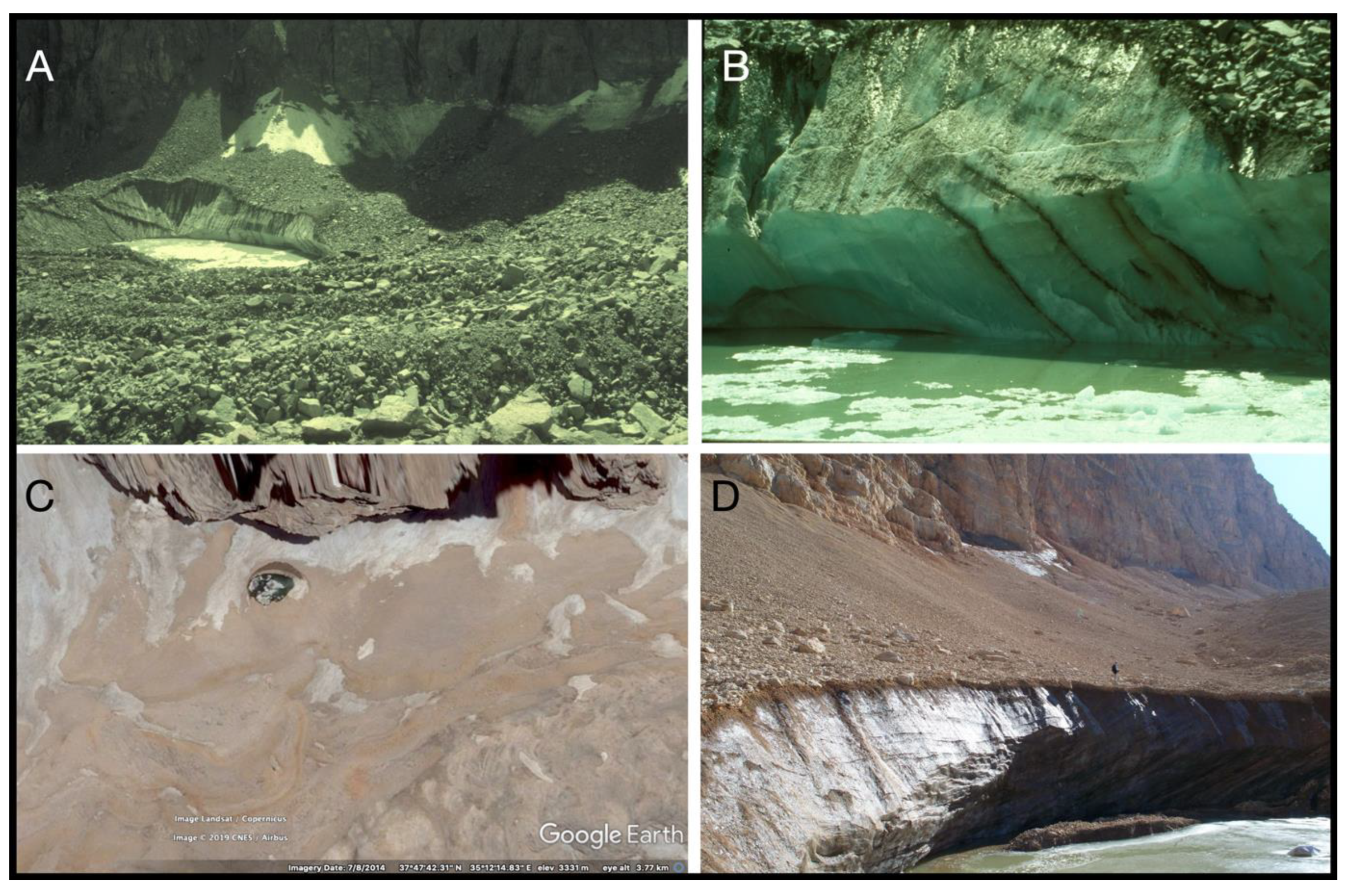
Figure 10 shows that substantial ice-cored cirque headwall can be seen under debris covers by glacier lake surface ‘meltwater pools’. An example is seen at South Fork Pass RG[37.0827,−118.4495] in the Sierra Nevada of California in the work of Guyton ([97], Figure 65). Google Earth coverage at Southfork Pass RG shows the changes in the size of the meltpool and its position; additionally, the movement of a boulder above the snout at [37.0826,-118.4488] between 1987 and 2022 was about 20 m.
A similar example from the Taurus Mountains in Turkey [98] is also shown, with massive glacier ice exposures below relatively thin (<1 m) debris cover in Figure 10C,D. With glacier ice, large quantities of water, and substantial ice cliffs, there is little doubt that the ice is at the pressure melting point and is not ‘permafrost’. GE examination in both these areas show a wide variety of topographic forms relating to moraines, remnant glaciers, and rock glaciers (see also Figure 1). The National Creek RG (Figure 4) might become, with long-term monitoring, similar to the exposures in Figure 10.

6.6. Surface Meltwater Pool in Large Rock Glacier Systems

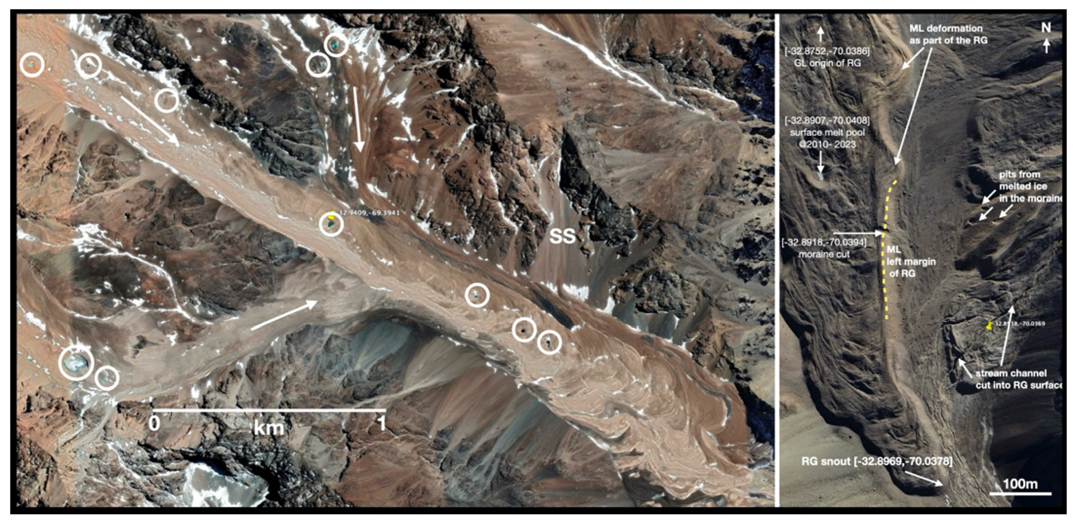
Meltwater ponds have recently been investigated on valley glaciers in many debris-covered glaciers in Asia [99] and in rock glacier–glaciers in the Hindu Kush [78]. The extensive rock glacier systems in the ‘Dry Andes’ have been used for hydrological [100] and permafrost mapping [101] purposes. An investigation with Google Earth shows that many of these systems, even small examples [102], have meltwater ponds. As well as single instances, these may be found in multiples along the lengths of RG. Examples are shown in Figure 11.

6.7. Rock Glaciers in Volcanic Areas

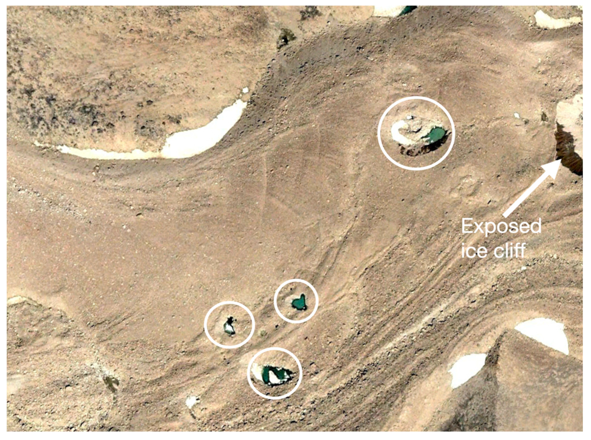
Many RG have been reported in South America in active volcanic areas [69], in the Elbrus and Kazbegi [105] massifs, as well as in Iran [106]. Figure 12 shows part of a rock glacier system in the Sabalan region, Iran, mapped as a glacier in the RGI (RGI60-12.01876) according to GLIMS guidelines as part of a glacier inventory [106]. The GE imagery (2004) shows the system with a small exposure of remnant glacier ice in the uppermost (headwall) area covered by a thick continuous debris towards the snout. As with other local glaciers, it grades into a rock glacier. Mapping in the 1970s [107,108] showed surface meltwater pools at two localities, while current GE images show several more nearer the snout, indicating a glacier core melting in situ.
‘Mount Sabalan (388160 N, 478500 E) is an inactive stratovolcano that rises to a height of 4811 m a.s.l. The glaciers on Sabalan are often characterised by a thick, continuous debris cover, and many glaciers appear to grade into or continue as rock glaciers’ (Ferrigno, 1991) ([108], p. 96).

7. Discussion

There have been many and varied reports of glacier ice being exposed in, usually small, rock glacier systems, but this is the first time that any of these have been brought together for independent inspection. Many other examples have been found over the course of several years, looking at what is now obtainable via Google Earth. (See Whalley [14] for methodology relating to mapping and the construction of information tensors.) Although neither a classification of features nor a georeferenced catalogue is provided, there is enough evidence to confirm the glacier ice cores within RG, for example, at ‘classic’ sites such as Galena Creek RG[44.642,-109.791] (Figure 7A) and Gruben RG[46.1718,7.9624] (Figure 7B).
This paper provides some ‘ground truth’ for the interpretations of geomorphological features in the 𝔻𝕞 to test and build confidence in models [56]. Ground truth [109] is, a term that implies a perfect or completely truthful representation of the relevant aspect of the world under study. Rarely will any dataset be perfect, and hence, some degree of error is likely to exist. Because of this situation, many researchers avoid the expression ‘ground truth’ and use terms such as ground or reference data instead. While the latter terms show an awareness of a major limitation with ground datasets, they do not actually address the impacts that arise as a function of using an imperfect ground dataset.
Observations are of a location (or at a location) at a given time. This applies generally but is also important to help confirmatory analyses or observations. The locations may have moved if they are on a moving body, or changes may have taken place. Examples of this have been given in the above data assembly. While observations may not have been recorded in a pre-digital age, at least some approximation is useful, and maps and photographs can supply these components of ‘ground truth’.
The dispute about the nature of rock glaciers and ice-cored moraines in Scandinavia and British Columbia [110,111,112] followed from the interpretation of topographic forms. Barsch collected most of the work carried out on RG in book format [59], which has become the epistle for the permafrost model of rock glacier formation and behaviour. This work stems from the ‘geoloecological’ approach to the mountain physical geography of the sub-title. Barsch was a student of Carl Troll, whose ‘zonal’ (or climatically determined) approach to landscapes [113] followed that of Peltier [114]. In essence, this geographical approach to landscape systematics suggests that certain landforms are found in specific climatic zones and, inversely, that certain landforms indicate specific climatic conditions. Barsch [59] used the findings of Wahrhaftig and Cox [54] in the Alaska Range to confirm that identified RG did indeed mean they were formed in permafrost. In fact, Wahrhaftig and Cox [54], like Capps [74] earlier, dug into the surface of several RG and found permafrost. This is hardly surprising as, in both areas, there is sporadic, even permanent, permafrost. This does not mean that a glacier origin is even unlikely but because ‘periglacial’ and mountain permafrost have been defined as not existing in the realm of glaciers, the zonal permafrost model for RG formation has become a major research output and is promoted in the work of Barsch [59] and Haeberli [58,82]. Much recent work, especially that appertaining to RG inventories, follows the dictum that ‘rock glaciers denote mountain permafrost’. The evidence presented here does not support this view but does indicate the presence of associated glacier ice. It is, for example, extremely difficult to credit the presence of permafrost in areas with high geothermal heat fluxes (Figure 12). However, many mountain glaciers may exist under permafrost; thermal conditions, especially in the higher reaches of the Alps [115]; and perhaps in areas of shadow close to mountain walls at lower altitudes.
There are some drillings into RG that indicate ‘permafrost’, i.e., thermal conditions. For example, Muragl RG[46.5076,9.9341] has been interpreted as permafrost, confirmed with geophysical and velocity surveys [116,117].
Questions arise concerning the extent to which potentially pre-existing permafrost was influenced by overriding during the LIA glacier advances, as well as the extent and rate to which permafrost and ground ice can build up, or recover, after ground exposure to the atmosphere due to glacier retreat ([117], p. 79).
At Muragl RG, which has a complex of snouts, rather than the RG having an independent permafrost existence, debris from the north faces of Piz Muragl SU[46.4978,9.9373] covered the LIA below in order for the RG complex to insulate ‘cold’ ice. There would have been sufficient glacier ice preserved to allow for glacier flow. The extent of the LIA Muragl gletscher (Vadret Muragl) has been modelled [118]. Importantly, the LIA glacier extent has been mapped, and its debris-free state is shown in the Swisstopo, ‘Interactive viewer’ [119] to locate maps in time. In this light, the maps provide a ground truth for interpreting present day observations.
A recent paper investigating Gruben RG[46.1718,7.9624] [70] presents some interesting new data. They follow the permafrost model stating the following:
‘Widespread supersaturated permafrost conditions were found in the rock glacier zone. Surface displacement rates in this zone are typical of permafrost creep behaviour’ ([70], p. 5940).
‘In particular, when automated remote sensing approaches are used, confusion and misinterpretations may arise in complex geomorphological settings [120] in particular where complex geomorphological contexts (e.g., glacier–permafrost interactions) hamper simple and straightforward “either–or” classification [121]’.
We need only confirm the presence of glacier ice to disprove the permafrost-only model. The RGIK methodology [25,53] is primarily geomorphological and field-based but detailed investigations can and do provide such evidence. In the case of the Gruben RG[46.1718,7.9624], not only has a massive glacier been found on the RG surface (Figure 7B), but its long-term behaviour and, hence, the origin of the ice, as seen from early topographic maps [84], shows that glacier ice has been covered by rock debris. The reader should examine the evidence of recent work [70,77,84] in order to evaluate the somewhat paltering statement included in the work of Wee et al. [70] by omitting evidence of massive glacier ice presence.
The various lines of evidence relating to ‘hidden ice’, glaciers in a climatic regime of volume depletion and debris availability, as well as the concepts of ‘mountain permafrost’ in the mountain domain, are clearly complex. However, this complexity is related to the lack of precision in definition (‘what do you mean by …’). This is answered with respect to ‘rock glaciers’ in the current paper by showing evidence—‘ground truth’—of glacier ice in rock glaciers, debris-covered glaciers, and their association with moraine formation.
Statements in papers, especially those relating to remote sensing and inventories, have referred to the RGIK [25,53] methodology (cited previously) in that RG are only ‘permafrost’ features and perhaps they are ‘periglacial’ landforms. Both these terms have been defined as being glacier-ice-exclusive. Queries such as, ‘what do you mean by …?’ also apply to less-tangible concepts such as ‘periglacial’, ‘paraglacial’, and ‘mountain permafrost’, as in geo-ecological (climatically zoned) explanations. The finding summarised in this paper deny the usefulness of these concepts and prefer the use of the more general and recognisable term ‘mountain domain’ (𝔻𝕞). The features identified and geolocated in the 𝔻𝕞 can then be recorded, mapped, and assessed in changing environments relatively unambiguously using [dLL] geolocation.

8. Conclusions

Despite the long-term controversies about what constitutes a rock glacier (RG), their significance with respect to water content and supply; their response to weather, climate, and catastrophic events; and their geomorphological behaviour still present significant problems. The basic ‘natural history’ of glacier ice and rock glacier formation as developed here shows that investigations on these features as important land systems; however, emphasis should now be placed on their glacier rather than ‘permafrost’ origins.
The basic findings can be listed, as follows:
  • Rock glaciers may show ice exposures below surface debris from top to snout; these exposures are related to massive ice of glacier origin.
  • A continuum of glacier ice exists from high elevation to low elevation. It is along this profile that glacier ice exposure and surface meltwater pools can most easily be found and monitored.
  • Rock debris accumulates on glacier surfaces to insulate the ice below, the melting of which may be of the order of many tens of years depending upon the local climate.
  • Whether a glacier GL, a glacier with debris load GLd, or a rock glacier RG form depends upon the (perhaps changing) mass balances of the two components.
  • No evidence of massive interstitial ice accumulation at the base of scree slopes (talus) can be recognised.
  • Rock glaciers provide a store of ice protected by the super-incumbent debris; this ice may descend to much lower altitudes than if it were not so protected.
  • The distinction between a glacier with debris cover and a rock glacier may not be distinct, but mapping RG as part of the extant ice body (hidden ice) of an area is permissible.
  • Google Earth can provide a valuable way to identify glacier and RG limits, as well as the presence of ice exposures.
  • Ice exposures should be mapped and recorded, as in an epidemic, to evaluate climate change effects in the cryosphere.
  • The presence of rock glaciers does not indicate mountain permafrost, and they should not be used for mapping permafrost.
  • The definition and usage of rock glaciers as being permafrost indicators by RGIK and as essential climatic variables should be deprecated.

Funding

This research received no external funding.

Institutional Review Board Statement

Not applicable.

Informed Consent Statement

Not applicable.

Data Availability Statement

Data used are cited in the references and/or by geolocation.

Acknowledgments

I thank my colleagues who have worked on rock glaciers in the mountains with me over many years. This paper is dedicated to the late Marth Andrews (1938–2025), Librarian at the Institute of Arctic and Alpine Research, Boulder, Colorado and her contributions to arctic science, to Sam Outcalt (1936–2023) for his diverse contributions to climatology and glaciology and Peter Birkeland (1934–2022), notable soil and Quaternary geomorphologist, who initiated my interest in rock glaciers.

Conflicts of Interest

The author declares no conflict of interest.

References

  1. Orlove, B.S.; Wiegandt, E.; Luckman, B.H. Darkening Peaks: Glacier Retreat, Science, and Society; University of California Press: London, UK, 2008. [Google Scholar]
  2. Cecil, L.D.; Green, J.R.; Thompson, L.G. (Eds.) Earth Paleoenvironments: Records Preserved in Mid- and Low-Latitude Glaciers; Kluwer: Dordrecht, The Netherlands, 2004. [Google Scholar]
  3. Zemp, M.; Frey, H.; Gärtner-Roer, I.; Nussbaumer, S.U.; Hoelzle, M.; Paul, F.; Haeberli, W.; Denzinger, F.; Ahstrøm, A.P.; Anderson, B. Historically unprecedented global glacier decline in the early 21st century. J. Glaciol. 2015, 61, 745–762. [Google Scholar] [CrossRef]
  4. Grove, J.M. The Little Ice Age, Ancient and Modern; Routledge: London, UK, 2004; Volume 2. [Google Scholar]
  5. Oerlemans, J. (Ed.) Glacier Fluctuations and Climate Change; Kluwer: Dordrecht, The Netherlands, 1989. [Google Scholar]
  6. Hattersley-Smith, G. The symposium on glacier mapping. Can. J. Earth Sci. 1966, 3, 737–741. [Google Scholar] [CrossRef]
  7. Röthlisberger, H. Introduction. Ann. Glaciol. 1986, 8, 1. [Google Scholar] [CrossRef]
  8. Kasser, P.; Röthlisberger, H. Some problems of glacier mapping experienced with the 1: 10000 map of the Aletsch Glacier. Can. J. Earth Sci. 1966, 3, 799–809. [Google Scholar] [CrossRef]
  9. Pelto, M.S.; Pelto, J. The Loss of Ice Worm Glacier, North Cascade Range, Washington USA. Water 2025, 17, 432. [Google Scholar] [CrossRef]
  10. Raup, B.; Racoviteanu, A.; Khalsa, S.J.S.; Helm, C.; Armstrong, R.; Arnaud, Y. The GLIMS geospatial glacier database: A new tool for studying glacier change. Glob. Planet. Change 2006, 56, 101–110. [Google Scholar] [CrossRef]
  11. RGI Consortium. Randolph Glacier Inventory—A Dataset of Global Glacier Outlines: Version 6.0: Technical Report, Global Land Ice Measurements from Space; NSIDC: Boulder, CO, USA, 2017. [Google Scholar]
  12. Raup, B.; Khalsa, S.J.S. GLIMS Analysis Tutorial; National Snow and Ice Data Center: Boulder, CO, USA, 2010. [Google Scholar]
  13. Millar, C.I.; Westfall, R.D. Rock glaciers and related periglacial landforms in the Sierra Nevada, CA, USA; inventory, distribution and climatic relationships. Quat. Int. 2008, 188, 90–104. [Google Scholar] [CrossRef]
  14. Whalley, W.B. Mapping small glaciers, rock glaciers and related features in an age of retreating glaciers: Using decimal latitude-longitude locations and ‘geomorphic information tensors’. Geogr. Fis. Din. Quat. 2021, 44, 55–67. [Google Scholar]
  15. Whalley, W.B. Geomorphological information mapping of debris-covered ice landforms using Google Earth: An example from the Pico de Posets, Spanish Pyrenees. Geomorphology 2021, 393, 107948. [Google Scholar] [CrossRef]
  16. Whalley, W.B.; Martin, H.E.; Gellatly, A.F. The problem of “hidden” ice in glacier mapping. Ann. Glaciol. 1986, 8, 181–183. [Google Scholar] [CrossRef]
  17. Corte, A.E. Glaciers and glaciolithic systems of the Central Andes 1980. In World Glacier Inventory: Proceedings of the Workshop at Riederalp, Switzerland, 17–22 September 1978; International Association of Hydrological Sciences: Wallingford, UK, 1980; pp. 11–24. [Google Scholar]
  18. Müller, F.; Caflisch, T.; Müller, G. Instructions for Compilation and Assemblage of Data for a World Glacier Inventory; Department of Geography, Swiss Federal Institute of Technology (ETH) Zürich: Zürich, Switzerland, 1977. [Google Scholar]
  19. Whalley, W.B.; Martin, H.E. Rock glaciers: II models and mechanisms. Prog. Phys. Geogr. 1992, 16, 127–186. [Google Scholar] [CrossRef]
  20. Herreid, S.; Pellicciotti, F. What can thermal imagery about glacier melt below rock debris. Frontiers 2020, 13, 621–627. [Google Scholar] [CrossRef]
  21. Harrison, S.; Jones, D.B.; Racoviteanu, A.E.; Anderson, K.; Shannon, S.; Betts, R.A.; Leng, R. Rock glacier distribution across the Himalaya. Glob. Planet. Change 2024, 239, 104481. [Google Scholar] [CrossRef]
  22. Knight, J.; Harrison, S.; Jones, D.B. Rock glaciers and the geomorphological evolution of deglacierizing mountains. Geomorphology 2019, 324, 14–24. [Google Scholar] [CrossRef]
  23. Jones, D.B.; Harrison, S.; Anderson, K.; Shannon, S.; Betts, R.A. Rock glaciers represent hidden water stores in the Himalaya. Sci. Total Environ. 2021, 793, 145368. [Google Scholar] [CrossRef] [PubMed]
  24. Jones, D.B.; Harrison, S.; Anderson, K.; Whalley, W.B. Rock glaciers and mountain hydrology: A review. Earth Sci. Rev. 2019, 193, 66–90. [Google Scholar] [CrossRef]
  25. RGIK. IPA Action Group Rock Glacier Inventories and Kinematics. Towards Standard Guidelines for Inventorying Rock Glaciers: Baseline Concepts (Version 4.2.2); RGIK: Fribourg, Switzerland, 2022; Available online: https://www.unifr.ch/geo/geomorphology/en/research/ipa-action-group-rock-glacier/ (accessed on 8 July 2025).
  26. Seppi, R.; Carton, A.; Zumiani, M.; Dall’Amico, M.; Zampedri, G.; Rigon, R. Inventory, distribution and topographic features of rock glaciers in the southern region of the Eastern Italian Alps (Trentino). Geogr. Fis. Din. Quat. 2012, 35, 185–197. [Google Scholar] [CrossRef]
  27. Bhat, I.A.; Rashid, R.; Ramsankaran, R.A.A.J.; Banerjee, A.; Vijay, S. A comprehensive rock glacier inventory for Jammu, Kashmir, and Ladakh, western Himalaya, India–Baseline for the permafrost research. Earth Syst. Sci. Data Discuss. 2024, 2024, 1–25. [Google Scholar] [CrossRef]
  28. Thiessen, R.; Bonnaventure, P.P.; Lapalme, C.M. Rock glacier inventory and predictive modeling in the Mackenzie Mountains: Predicting rock glacier likelihood with a generalized additive model. Arct. Sci. 2024, 10, 653–672. [Google Scholar] [CrossRef]
  29. Onaca, A.; Ardelean, F.; Urdea, P.; Magori, B. Southern Carpathian rock glaciers: Inventory, distribution and environmental controlling factors. Geomorphology 2017, 293, 391–404. [Google Scholar] [CrossRef]
  30. Abdullah, T.; Romshoo, S.A. A Comprehensive Inventory, Characterization, and Analysis of Rock Glaciers in the Jhelum Basin, Kashmir Himalaya, Using High-Resolution Google Earth Data. Water 2024, 16, 2327. [Google Scholar] [CrossRef]
  31. Mergili, M.; Kopf, C.; Müllebner, B.; Schneider, J.F. Changes of the cryosphere and related geohazards in the high-mountain areas of Tajikistan and Austria: A comparison. Geogr. Ann. Ser. A Phys. Geogr. 2012, 94, 79–96. [Google Scholar] [CrossRef]
  32. Hassan, J.; Chen, X.; Muhammad, S.; Bazai, N.A. Rock glacier inventory, permafrost probability distribution modeling and associated hazards in the Hunza River Basin, Western Karakoram, Pakistan. Sci. Total Environ. 2021, 782, 146833. [Google Scholar] [CrossRef]
  33. Martin, H.E.; Whalley, W.B. Rock glaciers: Part 1: Rock glacier morphology: Classification and distribution. Prog. Phys. Geogr. 1987, 11, 260–282. [Google Scholar] [CrossRef]
  34. Feynman, R. What is science? Resonance 2011, 16, 860–873. [Google Scholar] [CrossRef]
  35. Whalley, W.B. The geolocation of features on information surfaces and the use of the open and FAIR data principles in the mountain landscape domain and geoheritage. Permafr. Periglac. Process. 2024, 35, 98–108. [Google Scholar] [CrossRef]
  36. Barsch, D. Rockglaciers. In Advances in Periglacial Geomorphology; Clark, M.J., Ed.; Wiley: Chichester, UK, 1988; pp. 69–90. [Google Scholar]
  37. Clark, D.H.; Clark, M.M.; Gillespie, A.R. Debris-covered glaciers in the Sierra Nevada, California, and their implications for snowline reconstructions. Quat. Res. 1994, 41, 139–153. [Google Scholar] [CrossRef]
  38. Corte, A.E. Rock glacier taxonomy. In Rock Glaciers; Giardino, J.F., Jr., Shroder, J.F., Jr., Vitek, J.D., Eds.; Allen and Unwin: London, UK, 1987; pp. 27–39. [Google Scholar]
  39. Deluigi, N.; Lambiel, C. PERMAL: A Machine Learning Approach for Alpine Permafrost Distribution Modeling. Jahrestagung der Schweiz. Geomorph. Ges. 2013. Available online: https://www.researchgate.net/publication/267393953_PERMAL_a_machine_learning_approach_for_alpine_permafrost_distribution_modeling (accessed on 9 July 2025).
  40. Domaradzki, J. Blockströme in Kanton Graubunden. Ergebnisse Wissenschaftlichen Untersuchungen im Schweiz. National- park 1951, 3, 177–235. Available online: https://www.parcs.ch/snp/pdf_public/1588_domaradzki_blockstroeme_nf_1951.pdf (accessed on 7 July 2025).
  41. Evin, M. Lithology and fracturing control of rock glacier in southwestern Alps of France and Italy. In Rock Glaciers; Giardino, J.F., Jr., Shroder, J.F., Jr., Vitek, J.D., Eds.; Allen and Unwin: London, UK, 1987; pp. 83–106. [Google Scholar]
  42. Giardino, J.R.; Vitek, J.D. The significance of rock glaciers in the glacial-periglacial landscape continuum. J. Quat. Sci. 1988, 3, 97–103. [Google Scholar] [CrossRef]
  43. Ikeda, A.; Matsuoka, N. Pebbly versus bouldery rock glaciers: Morphology, structure and processes. Geomorphology 2006, 73, 279–296. [Google Scholar] [CrossRef]
  44. Johnson, P.G. Mass movement of ablation complexes and their relationship to rock glaciers. Geogr. Ann. A. 1974, 56, 93–101. [Google Scholar] [CrossRef]
  45. Johnson, P.G. Rock Glacier: Glacier Debris Systems or High-Magnitude Low-Frequency Flows. In Rock Glaciers; Giardino, J.F., Jr., Shroder, J.F., Jr., Vitek, J.D., Eds.; Allen and Unwin: London, UK; pp. 175–192.
  46. Jones, D.B.; Harrison, S.; Anderson, K. Mountain glacier-to-rock glacier transition. Global Plan. Change 2019, 181, 102999. [Google Scholar] [CrossRef]
  47. Leigh, J.; Evans, D.; Stokes, C.; Andreassen, L.; Carr, R. Glacial and periglacial geomorphology of central Troms and Finnmark county, Arctic Norway. J. Maps 2021, 17, 348–366. [Google Scholar] [CrossRef]
  48. Lindner, L.; Marks, L. Types of debris slope accumulations and rock glaciers in South Spitsbergen. Boreas 1985, 14, 139–153. [Google Scholar] [CrossRef]
  49. Østrem, G. Rock glaciers and ice-cored moraines, a reply to D. Barsch. Geogr. Ann. A. 1971, 53, 207–213. [Google Scholar] [CrossRef]
  50. Outcalt, S.I.; Benedict, J.B. Photo-interpretation of two types of rock glacier in the Colorado Front Range, USA. J. Glaciol. 1965, 5, 849–856. [Google Scholar] [CrossRef]
  51. Potter, J.N.; Steig, E.; Clark, D.; Speece, M.; Clark, G.T.; Updike, A.B. Galena Creek rock glacier revisited—New observations on an old controversy. Geogr. Ann. Ser. A Phys. Geogr. 1998, 80, 251–265. [Google Scholar] [CrossRef]
  52. Potter, N. Ice-cored rock glacier, Galena Creek, northern Absaroka Mountains, Wyoming. Geol. Soc. Am. Bull. 1972, 83, 3025–3058. [Google Scholar] [CrossRef]
  53. RGIK. IPA Action Group Rock Glacier Inventories and Kinematics. Rock Glacier Velocity as an associated parameter of ECV Perma-frost: Baseline Concepts (Version 3.2). Report. 2023. Available online: https://bigweb.unifr.ch/Science/Geosciences/Geomorphology/Pub/Website/IPA/CurrentVersion/Current_RockGlacierVelocity.pdf (accessed on 9 July 2025).
  54. Wahrhaftig, C.; Cox, A. Rock glaciers in the Alaska Range. Geol. Soc. Am. Bull. 1959, 70, 383–436. [Google Scholar] [CrossRef]
  55. Wilson, P. Relict rock glaciers, slope failure deposits, or polygenetic features? A reassessment of some Donegal debris landforms. Ir. Geogr. 2004, 37, 77–87. [Google Scholar] [CrossRef]
  56. Whalley, W.B. Remote Sensing and Landsystems in the Mountain Domain: FAIR Data Accessibility and Landform Identification in the Digital Earth. Remote Sens. 2024, 16, 3348. [Google Scholar] [CrossRef]
  57. Berthling, I. Beyond confusion: Rock glaciers as cryo-conditioned landforms. Geomorphology 2011, 131, 98–106. [Google Scholar] [CrossRef]
  58. Haeberli, W. Modern research perspectives relating to permafrost creep and rock glaciers: A discussion. Permafr. Periglac. Process. 2000, 11, 290–293. [Google Scholar] [CrossRef]
  59. Barsch, D. Rockglaciers. In Indicators for the Present and Former Geoecology in High Mountain Environments; Springer: Berlin, Germany, 1996; 331p. [Google Scholar] [CrossRef]
  60. Hu, Z.; Yan, D.; Feng, M.; Xu, J.; Liang, S.; Sheng, Y. Enhancing mountainous permafrost mapping by leveraging a rock glacier inventory in northeastern Tibetan Plateau. Int. J. Digit. Earth 2024, 17, 2304077. [Google Scholar] [CrossRef]
  61. Janke, J.; Regmi, N.; Giardino, J.; Vitek, J. 8.17 Rock Glaciers. Treatise on Geomorphology; Academic Press: San Diego, CA, USA, 2013; Volume 8, pp. 238–273. [Google Scholar]
  62. Lilleøren, K.S.; Etzelmüller, B.; Rouyet, L.; Eiken, T.; Hilbich, C. Transitional rock glaciers at sea-level in Northern Norway. Earth Surf. Dyn. Discuss. 2022, 10, 975–996. [Google Scholar] [CrossRef]
  63. Kääb, A.; Røste, J. Rock glaciers across the United States predominantly accelerate coincident with rise in air temperatures. Nat. Commun. 2024, 15, 7581. [Google Scholar] [CrossRef]
  64. Hu, Y.; Arenson, L.U.; Barboux, C.; Bodin, X.; Cicoira, A.; Delaloye, R.; Gärner-Rose, I.; Kääb, A.; Kellerer-Pirklbauer, A.; Lambiel, C.; et al. Rock glacier velocity: An essential climate variable quantity for permafrost. Rev. Geophys. 2025, 63, e2024RG000847. [Google Scholar] [CrossRef]
  65. Meng, T.; Tober, B.S.; Aguilar, R.J.; Daniel, M.F.; Jacobo-Bojórquez, R.A.; Nerozzi, S.; Holt, J.B. Effects of rock glacier dynamics on surface morphology and deformation. J. Geophys. Res. Earth Surf. 2025, 130, e2024JF008106. [Google Scholar] [CrossRef]
  66. Clark, D.H.; Steig, E.J.; Potter, N., Jr.; Gillespie, A.R. Genetic variability of rock glaciers. Geogr. Ann. Ser. A Phys. Geogr. 1998, 80, 175–182. [Google Scholar] [CrossRef]
  67. Whalley, W.B.; Palmer, C.F. A glacial interpretation for the origin and formation of the Marinet Rock Glacier, Alpes Maritimes, France. Geogr. Ann. Ser. A Phys. Geogr. 1998, 80, 221–236. [Google Scholar] [CrossRef]
  68. Konrad, S.K.; Humphrey, N.F.; Steig, E.J.; Clark, D.H.; Potter, N., Jr.; Pfeffer, W.T. Rock glacier dynamics and paleoclimatic implications. Geology 1999, 27, 1131–1134. [Google Scholar] [CrossRef]
  69. Whalley, W.B.; Marangunic, C. Landscapes and Landsystems: Rock glaciers in the mountain slope domain of South America. J. S. Am. Earth Sci. 2025. [Google Scholar]
  70. Wee, J.; Vivero, S.; Mathys, T.; Mollaret, C.; Hauk, C.; Lambiel, C.; Beutel, J.; Haeberli, W. Characterizing ground ice content and origin to better understand the seasonal surface dynamics of the Gruben rock glacier and the adjacent Gruben debris-covered glacier (southern Swiss Alps). Cryosphere 2024, 18, 5939–5963. [Google Scholar] [CrossRef]
  71. Heng, A.H.S.; Chew, F.T. Systematic review of the epidemiology of acne vulgaris. Sci. Rep. 2020, 10, 5754. [Google Scholar] [CrossRef]
  72. Whalley, W.B. An exposure of ice on the distal side of a lateral moraine. J. Glaciol. 1973, 12, 327–329. [Google Scholar] [CrossRef]
  73. Whalley, W.B.; Palmer, C.F.; Hamilton, S.J.; Kitchin, D. Supraglacial debris-transport variability over time: Examples from Switzerland and Iceland. Ann. Glaciol. 1996, 22, 181–186. [Google Scholar] [CrossRef]
  74. Capps, S.R. Rock glaciers in Alaska. J. Geol. 1910, 18, 359–375. [Google Scholar] [CrossRef]
  75. Azizi, F.; Whalley, W.B. Numerical modelling of the creep behaviour of ice-debris mixtures under variable thermal regimes. In Proceedings of the Sixth International Offshore and Polar Engineering Conference, Los Angeles, CL, USA, 26–31 May 1996; International Society of Offshore and Polar Engineers: Mountain View, CA, USA, 1996. [Google Scholar]
  76. Whalley, W.B.; Azizi, F. Rheological models of active rock glaciers: Evaluation, critique and a possible test. Permafr. Periglac. Process. 1994, 5, 37–51. [Google Scholar] [CrossRef]
  77. Whalley, W.B.; Azizi, F. Rock glaciers and protalus landforms: Analogous forms and ice sources on Earth and Mars. J. Geophys. Res. Planets 2003, 108, 8032. [Google Scholar] [CrossRef]
  78. Whalley, W.B. Glacier–rock glacier interactions in the eastern Hindu Kush, Nuristan, Afghanistan [35.92,71.13] in the period 1976–2019. Geogr. Ann. A 2024, 105, 91–120. [Google Scholar] [CrossRef]
  79. Whalley, W.B. A rock glacier and its relation to the mass balance of corrie glaciers, Strupbreen, Troms, Norway. Nor. Geogr. Tidsskr. 1976, 30, 52–55. [Google Scholar]
  80. Humlum, O.; Christiansen, H.H.; Juliussen, H. Avalanche-derived rock glaciers in Svalbard. Permafr. Periglac. Process. 2007, 18, 75–88. [Google Scholar] [CrossRef]
  81. Messerli, B.; Zurbuchen, M. Blockgletscher im Weissmies und Aletsch und ihre photogrammetrische Kartierung. Die Alp. 1968, 44, 139–152. [Google Scholar]
  82. Haeberli, W. Creep of Mountain Permafrost: Internal structure and flow of alpine rock glaciers. Mitteilungend der Vers. für Wasserbau Hydrol. und Glaziologie 1985, 77, 142. [Google Scholar]
  83. Whalley, W.B. Enhancing the Digital Earth via digital decimal geolocation and the FAIR data principles. Earth Sci. Syst. Soc. 2024, 4, 10110. [Google Scholar] [CrossRef]
  84. Whalley, W.B. The Glacier—Rock Glacier Mountain Landsystem: An example from North Iceland. Geogr. Ann. Ser. A Phys. Geogr. 2021, 103, 346–367. [Google Scholar] [CrossRef]
  85. Anderson, L.W.; Anderson, D.S. Weathering rinds on quartzarenite clasts as a relative-age indicator and the glacial chronology of Mount Timpanogos, Wasatch Range, Utah. Arct. Alp. Res. 1981, 13, 25–31. [Google Scholar] [CrossRef]
  86. SummitPost.org. 100 Years on the Timanogos Glacier. Available online: https://www.summitpost.org/page/186144 (accessed on 7 July 2005).
  87. Hotaling, S.; Morriss, M. Mountain rock glaciers: An overlooked, climate resilient water source for Utah? In Proceedings of the 17th Annual Salt Lake County Watershed Symposium, West Valley, CL, USA, 15–16 November 2023; Available online: https://www.youtube.com/watch?v=YhFZmVFKrgQ (accessed on 7 July 2005).
  88. Reheis, M.J. Source, transportation and deposition of debris on Arapaho Glacier, Front Range, Colorado, USA. J. Glaciol. 1975, 14, 407–420. [Google Scholar] [CrossRef]
  89. Gabrielli, S.; Spagnolo, M.; De Siena, L. Geomorphology and surface geology of Mount St. Helens volcano. J. Maps 2020, 16, 585–594. [Google Scholar] [CrossRef]
  90. Deline, P.; Hewitt, K.; Reznichenko, N.; Shugar, D. Rock avalanches onto glaciers. In Landslide Hazards, Risks, and Disasters; Elsevier: Amsterdam, The Netherlands, 2022; pp. 269–333. [Google Scholar]
  91. Bull, C.; Marangunic, C. The earthquake-induced slide on the Sherman Glacier, south-central Alaska, and its glaciological effects. Phys. Snow Ice Proc. 1967, 1, 395–408. [Google Scholar]
  92. Uhlmann, M.; Korup, O.; Huggel, C.; Fischer, L.; Kargel, J.S. Supra-glacial deposition and flux of catastrophic rock–slope failure debris, south-central Alaska. Earth Surf. Process. Landf. 2013, 38, 675–682. [Google Scholar] [CrossRef]
  93. Jiskoot, H. Long-runout rockslide on glacier at Tsar Mountain, Canadian Rocky Mountains: Potential triggers, seismic and glaciological implications. Earth Surf. Process. Landf. 2011, 36, 203–216. [Google Scholar] [CrossRef]
  94. Hotaling, S.; Becker, K.; Morriss, M. Rock Glaciers in Utah (Fact Sheet); Utah State University Extension: Logan, UT, USA, 2024; Available online: https://digitalcommons.usu.edu/extension_curall/2417/ (accessed on 7 July 2005).
  95. Chaix, A. Les coulées de blocs du Parc national suisse. Nouvelles mesures et comparaison avec les «rock stream» de la Sierra Nevada de Californie. Le Globe. Rev. Genevoise Géographie 1943, 82, 121–128. [Google Scholar] [CrossRef]
  96. Kesseli, J.E. Rock streams in the Sierra Nevada, California. Geogr. Rev. 1941, 31, 203–227. [Google Scholar] [CrossRef]
  97. Guyton, B. Glaciers of California: Modern Glaciers, Ice Age Glaciers, the Origin of Yosemite Valley, and a Glacier Tour in the Sierra Nevada; Univ of California Press: Auckland, CL, USA, 1998; Volume 59. [Google Scholar]
  98. Çalişkan, O.; Gürgen, G.; Yilmaz, E.; Yeşilyurt, S. Debris-Covered Glaciers in Aladağlar Mountains (Turkey). Trans. Jpn. Geomorphol. Union 2011, 32, 121–128. [Google Scholar]
  99. Miles, K.E.; Hubbard, B.; Irvine-Fynn, T.; Miles, E.S.; Quincey, D.J.; Rowan, A.V. Hydrology of debris-covered glaciers in High Mountain Asia. Earth Sci. Rev. 2020, 207, 103212. [Google Scholar] [CrossRef]
  100. Azócar, G.; Brenning, A. Hydrological and geomorphological significance of rock glaciers in the dry Andes, Chile (27–33°S). Permafr. Periglac. Process. 2010, 21, 42–53. [Google Scholar] [CrossRef]
  101. Angillieri, M.Y.E. Permafrost distribution map of San Juan Dry Andes (Argentina) based on rock glacier sites. J. S. Am. Earth Sci. 2017, 73, 42–49. [Google Scholar] [CrossRef]
  102. Whalley, W.B. Comment on “Ice content and interannual water storage changes of an active rock glacier in the dry Andes of Argentina” by Halla et al. (2021). Cryosphere 2023, 17, 699–700. [Google Scholar] [CrossRef]
  103. Blöthe, J.H.; Halla, C.; Schwalbe, E.; Bottegal, E.; Trombotto Liaudat, D.; Schrott, L. Surface velocity fields of active rock glaciers and ice-debris complexes in the Central Andes of Argentina. Earth Surf. Process. Landf. 2020, 46, 504–522. [Google Scholar] [CrossRef]
  104. Monnier, S.; Kinnard, C. Pluri-decadal (1955–2014) evolution of glacier–rock glacier transitional landforms in the central Andes of Chile (30–33° S). Earth Surf. Dyn. 2017, 5, 493–509. [Google Scholar] [CrossRef]
  105. Tielidze, L.G.; Cicoira, A.; Nosenko, G.A.; Eaves, S.R. The First Rock Glacier Inventory for the Greater Caucasus. Geosciences 2023, 13, 117. [Google Scholar] [CrossRef]
  106. Moussavi, M.; Valadan Zoej, M.J.; Vaziri, F.; Sahebi, M.R.; Rezaei, Y. A new glacier inventory of Iran. Ann. Glaciol. 2009, 50, 93–103. [Google Scholar] [CrossRef]
  107. Schweizer, G. Klimatisch bedingte geomorphologische und glaziologische Züge der Hochregion vorderasiatischer Gebirge (Iran und Ostanatolien). In Landschaftökologie der Hochgebirge Eurasiens; Franz Steiner Verlag GMBH: Stuttgart, Germany, 1972; pp. 221–236. [Google Scholar]
  108. Ferrigno, J.G. Glaciers of Iran Ferrigino G31–47, Satellite Image Atlas of Glaciers of the World. In Glaciers of the Middle East and Africa; Williams, R.S., Ed.; US Government Printing Office: Washington, DC, USA, 1991; p. 70. [Google Scholar]
  109. Foody, G.M. Ground Truth in Classification Accuracy Assessment: Myth and Reality. Geomatics 2024, 4, 81–90. [Google Scholar] [CrossRef]
  110. Østrem, G. Ice-cored moraines in Scandinavia. Geogr. Ann. Ser. A Phys. Geogr. 1971, 46, 282–337. [Google Scholar]
  111. Østrem, G. The transient snowline and glacier mass balance in southern British Columbia and Alberta, Canada. Geogr. Ann. Ser. A Phys. Geogr. 1964, 55, 93–106. [Google Scholar] [CrossRef]
  112. Barsch, D. Rock glaciers and ice-cored moraines. Geogr. Ann. Ser. A Phys. Geogr. 1971, 53, 203–206. [Google Scholar] [CrossRef]
  113. Troll, C. High mountain belts between the polar caps and the equator: Their definition and lower limit. Arct. Alp. Res. 1973, 5 (Suppl. 3), A19–A27. [Google Scholar] [CrossRef]
  114. Peltier, L.C. The geographic cycle in periglacial regions as it is related to climatic geomorphology. Ann. Assoc. Am. Geogr. 1950, 40, 214–236. [Google Scholar] [CrossRef]
  115. Haefeli, R.; Brentani, F. Observations in a cold ice cap. J. Glaciol. 1955, 2, 571–582. [Google Scholar] [CrossRef]
  116. Kunz, J.; Kneisel, C. Glacier–permafrost interaction at a thrust moraine complex in the glacier forefield Muragl, Swiss Alps. Geosciences 2020, 10, 205. [Google Scholar] [CrossRef]
  117. Kääb, A.; Kneisel, C. Permafrost creep within a recently deglaciated glacier forefield: Muragl, Swiss Alps. Permafr. Periglac. Process. 2006, 17, 79–85. [Google Scholar] [CrossRef]
  118. Jouvet, G.; Picasso, M.; Rappaz, J.; Blatter, H. A new algorithm to simulate the dynamics of a glacier: Theory and applications. J. Glaciol. 2008, 54, 801–811. [Google Scholar] [CrossRef]
  119. Swisstopo. Map Viewer. 2025. Available online: https://www.swisstopo.admin.ch/en/map-viewer-mapgeoadminch (accessed on 12 June 2025).
  120. Whalley, W.B. Gruben glacier and rock glacier, Wallis, Switzerland: Glacier ice exposures and their interpretation. Geogr. Ann. Ser. A Phys. Geogr. 2020, 102, 141–161. [Google Scholar] [CrossRef]
  121. Haeberli, W.; Arenson, L.U.; Wee, J.; Hauck, C.; Mölg, N. Discriminating viscous-creep features (rock glaciers) in mountain permafrost from debris-covered glaciers–a commented test at the Gruben and Yerba Loca sites, Swiss Alps and Chilean Andes. Cryosphere 2024, 18, 1669–1683. [Google Scholar] [CrossRef]
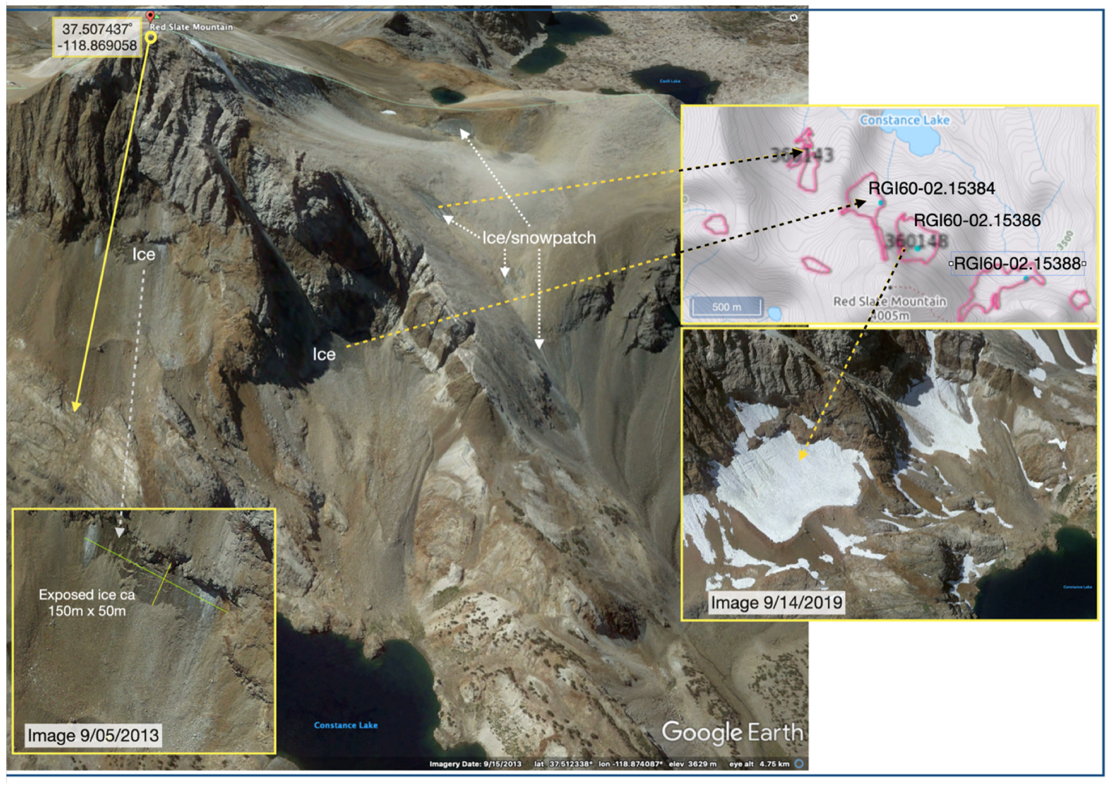
Figure 1. Oblique and near vertical images of glacial features around Red Slate Mountain, [37.5074,-118.8690], Sierra Nevada, CA, USA. Main Google Earth @2013 image looking southwest with detailed interpretation indicated on it; inset interpretations from GE @2019 and top inset from GLIMS glacier viewer. Main image © Google Earth.
Glacies 02 00008 g001
Figure 2. The diversity of landforms related to or attributed to rock glaciers in the mountain domain (𝔻𝕞) showing ‘it all depends on what you mean by …’. The named tabs on the right with their ‘two-letter labels’ are again landforms that can be mapped and that may, or may not, be associated with RG in general. References in Figure [13,19,36,37,38,39,40,41,42,43,44,45,46,47,48,49,50,51,52,53,54,55] and see [56] for further discussion.
Glacies 02 00008 g002
Figure 3. Debris cover of glaciers. Active glacier margins in A and B and decaying snouts C and D. (A) Left side of the Kennicott Glacier, Alaska [61.4791,-142.8871] @1994 showing debris cover in a down-wasting section, with a contiguous clean glacier ice to the left. (B) Left lateral moraine of the Glacier de Tsjiore Nuove, Switzerland, where an ice core has been reported [72]. The image from 1984 is from [46.0069,7.4526], looking north. The height difference between the active glacier and the LIA moraine crest is clearly visible. (C) Debris cover of disintegrating ice left by the retreating Vatnajökull, Iceland [64.0916,-16.3278] @1973. (D) Snout of the north tongue of the Feegletscher, Switzerland [46.0958,7.8987] [73], where a steep cliff with very-thin debris is typically dark grey in colour and here contrasts with the lighter grey of the rockfall deposit on the snout in the 1950s. The image is from @1997 and the snout has retreated from the location given. All images © W. Brian Whalley.
Glacies 02 00008 g003
Figure 4. National Creek RG, Alaska. The arrow at the centre of 4A is approximately at [61.4841,-142.8436]130; the arrow points to a bearing of 130° and marks the position of the heavily vegetated and stable surface (B). The view at C is from about [61.4844,-142.8475]002 and shows ice appearing from the side of a longitudinal ridge as the surface slope becomes steeper. Kennicott Glacier in the background. All images © W. Brian Whalley.
Glacies 02 00008 g004
Figure 5. (A) Surficial debris on the right margin of Strupbreen, Norway, merging with debris and forming a small RG over the col (arrowed) [69.7024,20.2040] @1974. As the surface of the main glacier has lowered, the debris-covered ice has been trapped in a side valley, forming a small RG. Image © W. Brian Whalley. (B) Weissmies RG, Switzerland, with the snout at RGs [46.1430,8.0384] formed by glacier ice no longer being constrained by the right lateral moraine (ML) (dashed line). Image © Google Earth.
Glacies 02 00008 g005
Figure 6. Widening of crevasses under a debris cover—an aerial image from 1983 compared with a GE image from 2004. The arrow shows the same feature. The ice for the small RG was from the Rex Glacier to the west of the feature. Images © W. Brian Whalley (left) and © Google Earth (right).
Glacies 02 00008 g006
Figure 7. Glacier ice exposures from classic RG sites. (A) Ice core extracted by Noel Potter and held by Nel Caine at [44.6440,-109.7926] on Chapman Field Excursion, 1986 ([82], Figure 3). Potter [52] originally described this site with further references at RG[44.642,-109.791] {[35,51,65,66]}. (B) Glacier ice with debris banding on Gruben RG[46.1718,7.9624] below a relatively thin debris cover. A full explanation is given by Whalley [83]. Images © W. Brian Whalley.
Glacies 02 00008 g007
Figure 8. Summary diagram showing glacier ice exposures in the Nautardalur RG[65.4910,-18.3692], Iceland, as reported in the work of Whalley [85] including the Figures designated. The ‘two letter labels’ of landforms from which debris is derived and transported are as follows: PL—plateau surface; FF—free face; GL—glacier; GLd—debris-covered glacier; RG—rock glacier. Images © W. Brian Whalley.
Glacies 02 00008 g008
Figure 9. (A) Mt Timpanogos, Utah RG[40.3922,-111.6405] with copious talus development in the north-facing cliffs; however, with the glacier ice being covered by rockfall, the glacier has been preserved as an RG. The red circles in the upper portion show ice exposures as meltwater pools within the debris—also see Figure 10. (B) Glacier ice exposure in the core of the Arapaho Rock RG[40.0223,-105.6386] @1964 in [50], Figure 6—‘exposed 400 m down-valley from the base of the cirque head wall. Bands of dark-coloured ice, probably representing annual ablation surface, dip up-valley at angles of 40 to 45°; 21 August 1964′. Photo courtesy of © Sam Outcalt. (C) Debris rockslide onto the surface of a small glacier in the red circle is a boulder at [52.0822,-117.7856] @2011. Monitoring this small glacier with a portion being covered by the debris will be possible remotely using GE. Images A and C © Google Earth.
Glacies 02 00008 g009
Figure 10. Meltpool exposures of glacier ice in rock glaciers below debris near cirque headwalls. (A,B) Below Southfork Pass, Sierra Nevada, California, B shows detail of the glacier ice. GLd[37.0715,-118.4521] @1992. Images courtesy of © Douglas Clark. (C) Below north-facing cliffs, Yedigoller/Direktas RG[37.7960,35.2009] @2014, Taurus Mountains. Note: many other examples can be seen developing in this area in recent GE imagery, e.g., [37.7787,35.1771] @2016. (D) Detail of meltpool in C; figure for scale. Image courtesy of © Onur Çalişkan (also see the work of Çalişkan et al. [98]).
Glacies 02 00008 g010
Figure 11. Two examples of glacier–rock glacier systems of varying complexities in the Andes (see also the work of Whalley and Marangunic [69]). In A, the white circles show the locations of meltwater pools, while the arrows point to rock glacier flow direction. In B, the RGs depicts the rock glacier snout location, while ML depicts the left lateral moraine. Complex RG are visible on the right-hand side of the image. A. The meltwater pool approximately in the centre is at RG.p[-32.9409,-69.3941] @2023. For more information, see the work of Blöthe et al. [103]. B. One of the ‘transitional’ forms in Monnier and Kinnard [104] located at [-32.8969,-70.0378} @2023. Images © Airbus/Google Earth.
Glacies 02 00008 g011
Figure 12. Lower centre section of an RG 2 km south of Kuh-e-Sabalan (NW Iran, 4794 m). GE images show meltwater ponds (circled); the largest is at [38.2503,47.8345] @2004. Later images show substantial changes to the detailed topography. Ice cliffs below the thin debris load and also near the complex snout lobe (3700 m) confirm the presence of massive ice. © Google Earth/Airbus.
Glacies 02 00008 g012
Disclaimer/Publisher’s Note: The statements, opinions and data contained in all publications are solely those of the individual author(s) and contributor(s) and not of MDPI and/or the editor(s). MDPI and/or the editor(s) disclaim responsibility for any injury to people or property resulting from any ideas, methods, instructions or products referred to in the content.