
Glacial Thrusts: Implications for the Crustal Deformation of the Icy Satellites

 , , , ,
  , , and
Abstract
1. Introduction
2. Background
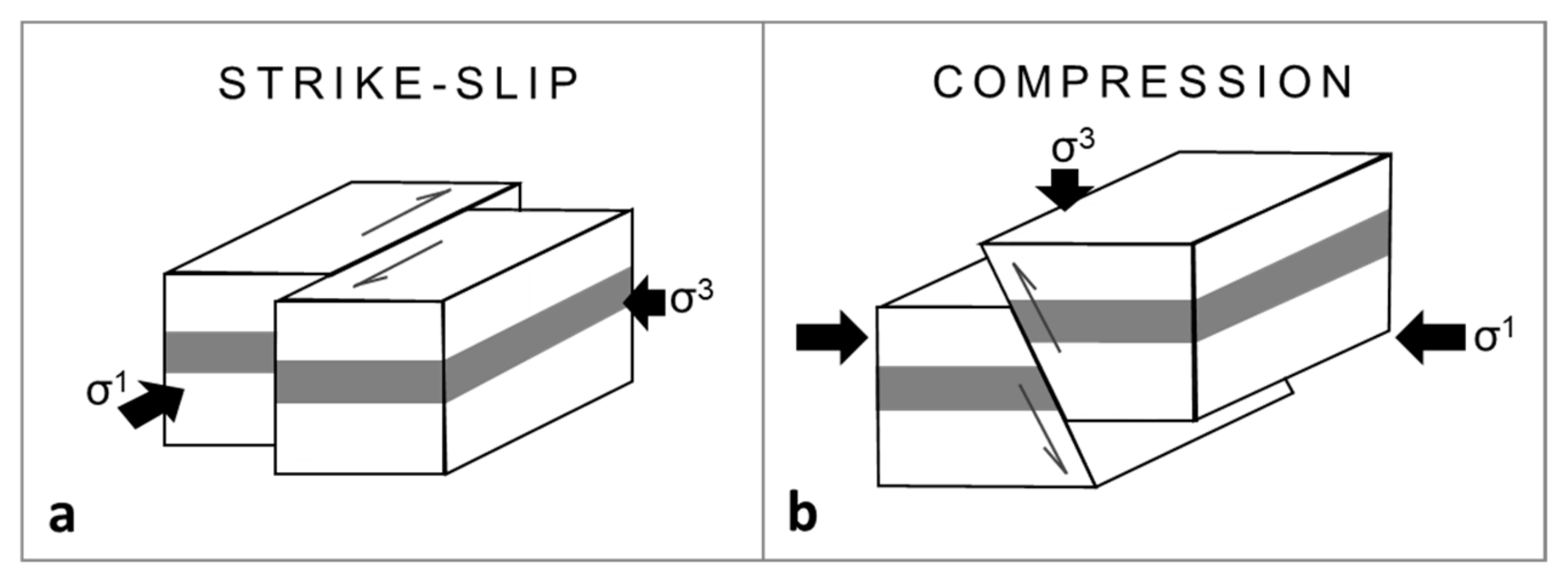
2.1. Strike-Slip
2.2. Compression
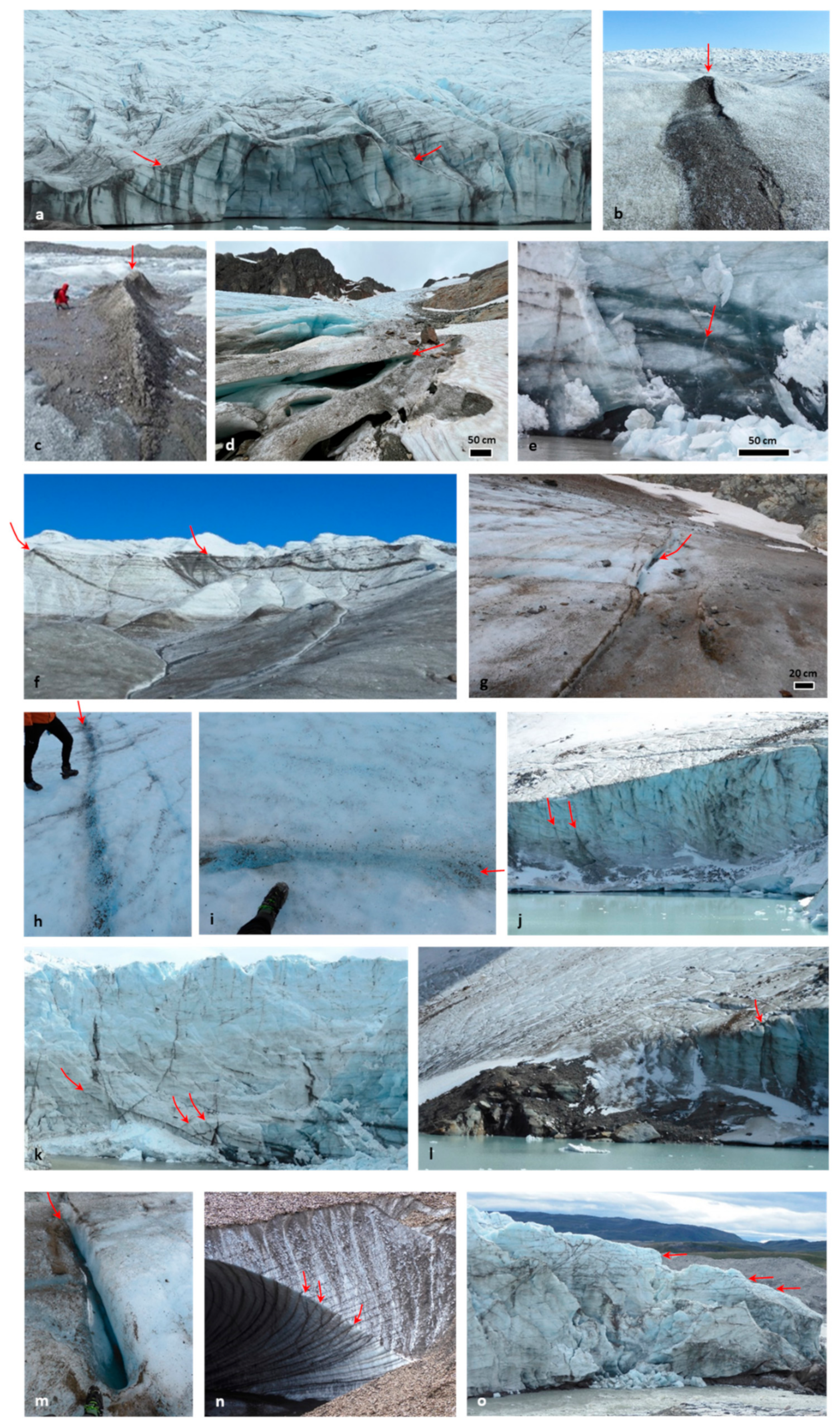
2.3. Glacial Thrusts
- (I)
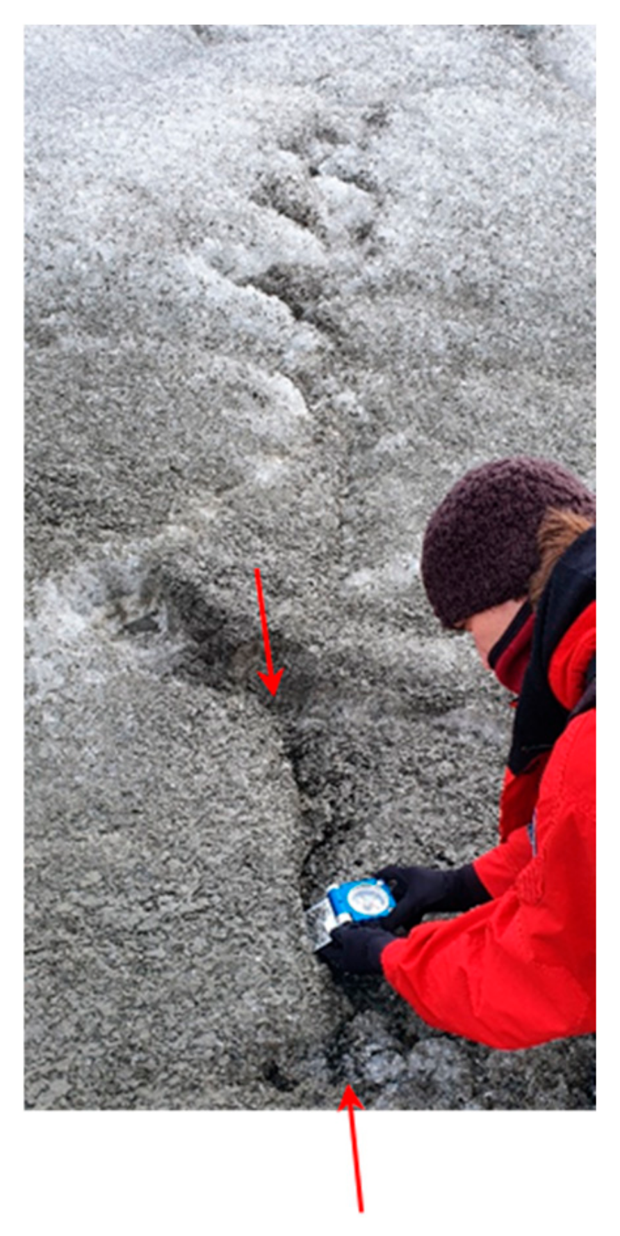
- Thrusts typically develop with a gentle low-angle dip, which steepens up to 40° as they reach the surface, forming small steps, duplexing the topography (i.e., topographic growth due to the thrust kinematics that leads to internal layer repetition) or cutting the topographic slopes (Figure 3f,g). Usually, thrust traces are darker than the surrounding ice due to the transport of debris from the underlying bedrock, soil and dust.
- (II)
- Together with percolation water, the friction produced by the sliding of the thrust planes causes ice melting and lubrication, which can subsequently refreeze, resulting in the healing of the thrust fracture (Figure 3h,i). In fact, the process of compression, melting, and refreezing, or pressure solution [25,41], eliminates air bubbles from the ice, resulting in a dense, coarse crystalline ice structure [22]. In this way, the linear trace of such thrusts is shown on the surface as clear ice, also referred to as ‘blue ice’.
- (III)
- (IV)
- In addition, compressional structures often develop on pre-existing weakness planes in the ice, such as fractures and crevasse (Figure 3l,m). This occurs as a result of reactivation of older tensile fractures [51,59]. In this way, these thrusts appear on the surface with a high-angle dip that tends to flatten at depth.
- (V)
- Moreover, at depth, thrusts can often be concealed within the glacier layers, which facilitate their occurrence and motion, similarly to how bedrock thrusts often form on weak lithologies, such as clay, or lithological variations that act as décollement, allowing thrust kinematics [41]. Therefore, ice layers within the glacier can also be reactivated as thrusts (Figure 3n,o).
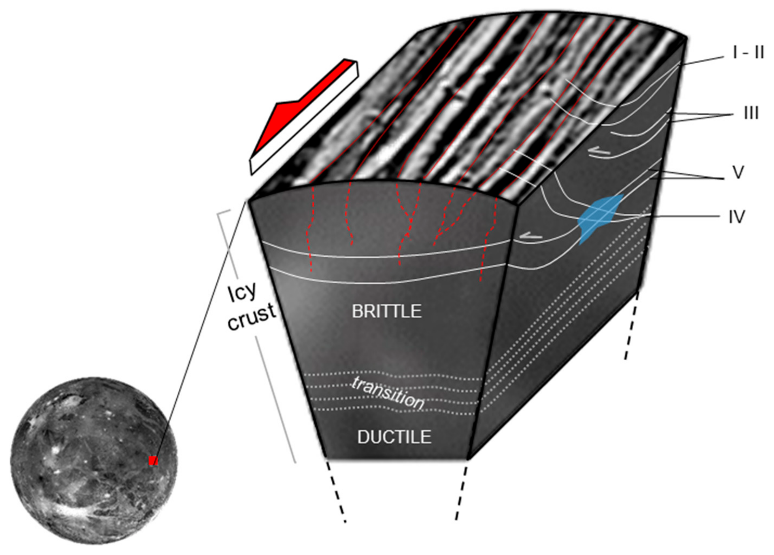
2.4. Icy Satellites
3. Approaches and Examples
3.1. Fieldwork
3.2. Remote Sensing
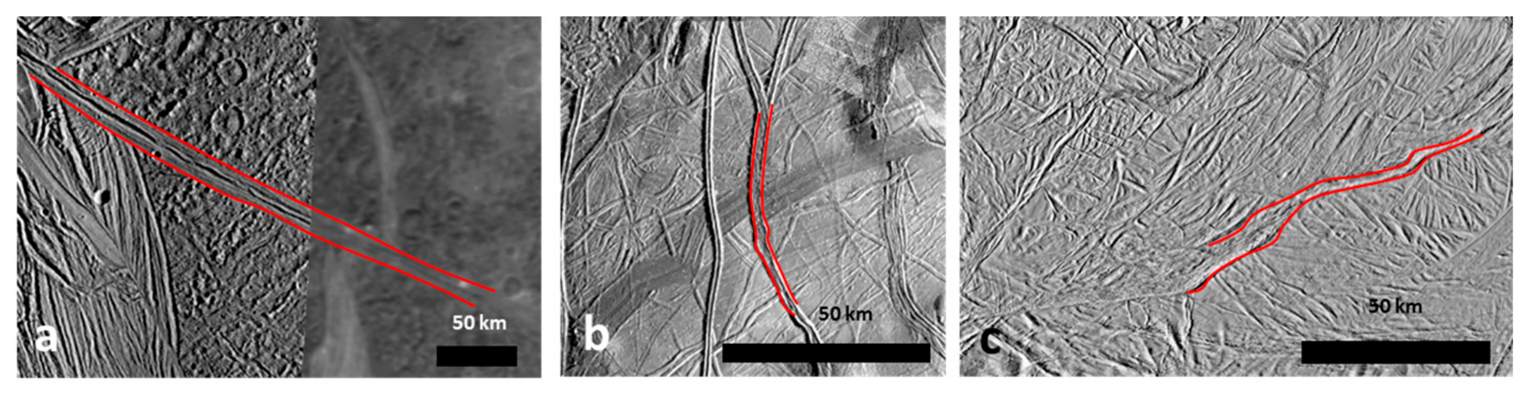
3.2.1. Structural Mapping
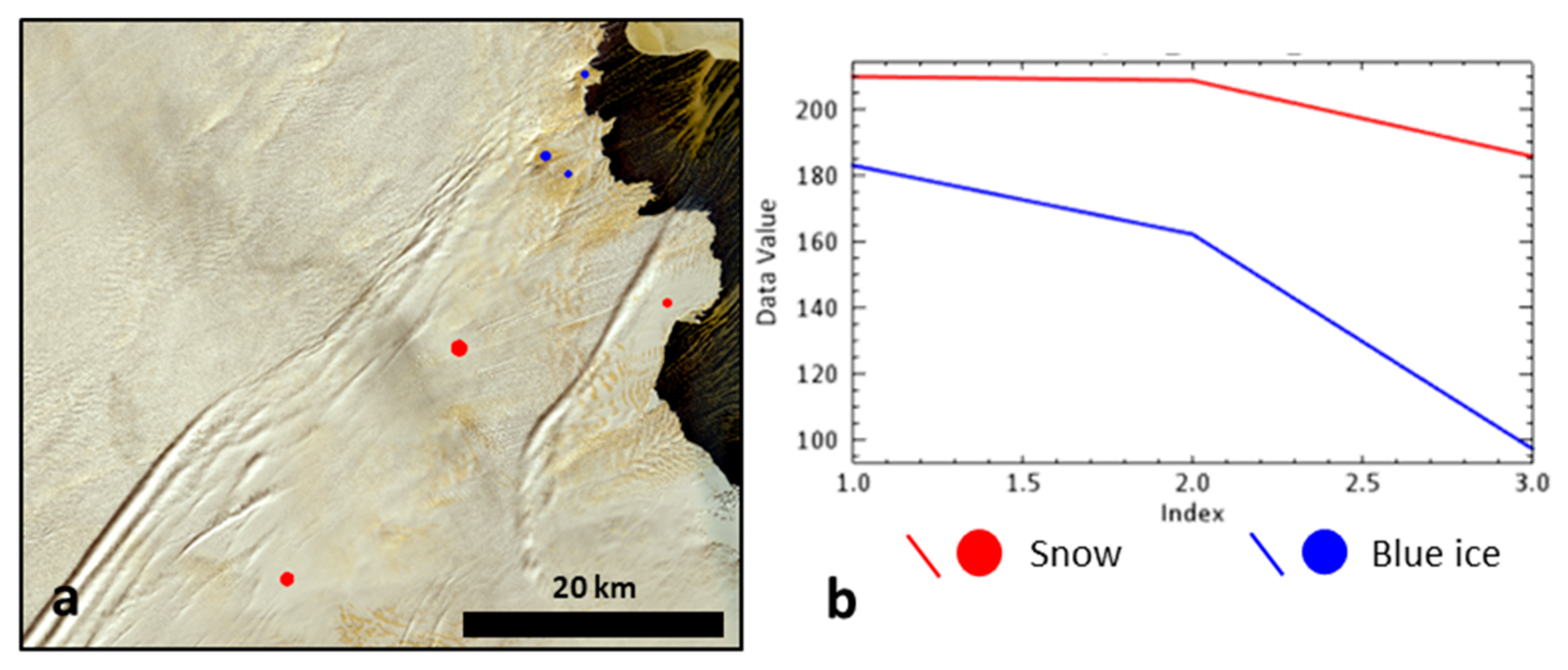
3.2.2. Spectral Analysis
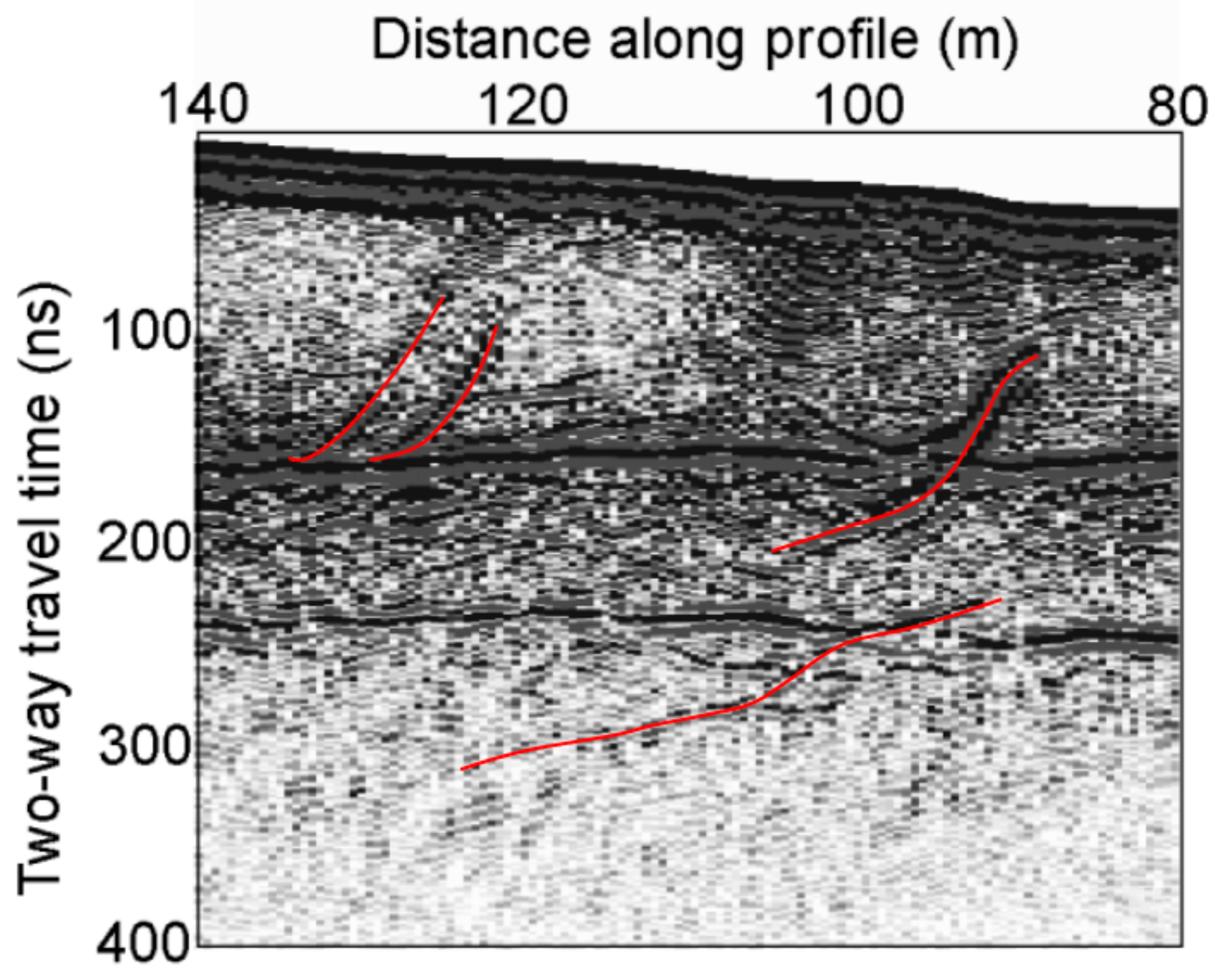
3.2.3. Ground Penetrating Radar
4. Discussion and Summary
- (i)
- The main categories of thrusts that we investigated at the glacier’s surface provide a starting point for understanding what we can expect at the surface of icy satellites. Moreover, this classification provides us the means to detect these structures on icy satellites. On the icy satellites, thrusts of category I can be detected along the margins of the shear zones, where they trend ≤ 45° to the shear zone boundaries or are perpendicular to extensional structures. Thrusts I and II can also show traces that may provide evidence of linear features composed of different materials, such as ice mixtures with dust or clear ice, which could support their identification. Detection of these two categories is possible through optical and spectral remote sensing at high resolution, which are onboard on the upcoming missions (JANUS, up to 2.4 m/pixel, and MAJIS, 0.5–5.5 μm, on JUICE [118]; EIS, up to 0.5 m/pixel, and MISE, 0.8–5.0 μm, on Europa Clipper [119]). Thrusts of category IV can be detected through detailed structural analysis of the study area, where high-angle structures are consistent with the occurrence of compression within the shear zone. This category can be revealed along the margins of the shear zone, and, with optical data, penetrating radar data will be crucial. Such instruments will be extremely important for detecting thrust development at depth and, in particular, for investigating categories III and V, which are concealed at depth. At present, no such data are available for icy satellite surfaces. However, penetrating radars are part of the equipment on JUICE and Europa Clipper (RIME, up to a depth of 9 km, and REASON, ≥30 km, respectively [120,121].
- (ii)
- A significant amount of brittle deformation, including tensile and strike-slip faults, is observed in the upper portions of icy satellite crusts. These brittle portions cover underlying blind thrusts, which could compensate for the deformation observed at the surface. As such, it is reasonable to hypothesize the presence of deep compressional deformation structures on icy satellites. Thrusts on glaciers typically form at depth, near the brittle–ductile transition zone. Similarly, compressional structures on icy satellites may develop at depth, particularly in regions affected by strike-slip kinematics, which can induce longitudinal compression. Although the location of the brittle–ductile transition on icy satellites varies depending on the body’s crust, a large transition zone is assumed, capable of hosting long thrusts that accommodate surface deformation.
- (iii)
- Besides the different deformation processes, a key difference between glaciers and icy satellites is that glaciers are unconfined masses, while the icy satellite crusts are confined bodies. Glaciers are less constrained in balancing their deformation compared to the more constrained deformation of icy satellite shear zones. Nevertheless, the analogies between glaciers and deformed icy satellite surfaces help us understand how observed deformations might be accommodated. In addition, the presence of thrusts that allow the compensation of unconfined masses, such as glaciers, further supports the assumption of their occurrence on confined bodies, such as icy satellite crusts, which require necessary balancing.
- (iv)
- Thrust motion can generate ice melting on glaciers and create favorable discontinuities for groundwater flow. On icy satellites, compressional structures can similarly serve as conduits for fluid propagation and play a key role in the deep fracture network that could feed potential subsurface liquid reservoirs. These may be sandwiched between crustal layers and occur beneath the ocean that characterizes several icy satellites.
Author Contributions
Funding
Institutional Review Board Statement
Informed Consent Statement
Data Availability Statement
Acknowledgments
Conflicts of Interest
References
- Prockter, L.M. Ice in the solar system. Johns Hopkins APL Tech. Dig. 2005, 26, 175–188. [Google Scholar]
- Bartels-Rausch, T.; Bergeron, V.; Cartwright, J.H.; Escribano, R.; Finney, J.L.; Grothe, H.; Gutiérrez, P.J.; Haapala, J.; Kuhs, W.F.; Pettersson, J.B.C.; et al. Ice structures, patterns, and processes: A view across the icefields. Rev. Mod. Phys. 2012, 84, 885–944. [Google Scholar] [CrossRef]
- Murray, B.J.; Knopf, D.A.; Bertram, A.K. The formation of cubic ice under conditions relevant to Earth’s atmosphere. Nature 2005, 434, 202–205. [Google Scholar] [CrossRef] [PubMed]
- Schubert, G.; Spohn, T.; Reynolds, R.T. Thermal histories, compositions and internal structures of the moons of the solar system. In Satellites; Burns, J.A., Matthews, M.S., Eds.; Arizona University Press: Tucson, AZ, USA, 1986; pp. 224–292. [Google Scholar]
- Hussmann, H.; Sotin, C.; Lunine, J.I. Interiors and evolution of icy satellites. In Treatise on Geophysics; Spohn, T., Schubert, G., Eds.; Elsevier: Oxford, UK, 2007; Volume 10, pp. 509–539. [Google Scholar]
- Hobbs, P.V. Ice Physics; OUP Oxford: Oxford, UK, 2010. [Google Scholar]
- Sloan, E.D., Jr.; Koh, C.A. Clathrate Hydrates of Natural Gases; CRC Press: Boca Raton, FL, USA, 2007. [Google Scholar]
- Finney, J.L.; Bowron, D.T.; Soper, A.K.; Loerting, T.; Mayer, E.; Hallbrucker, A. Structure of a new dense amorphous ice. Phys. Rev. Lett. 2002, 89, 205503. [Google Scholar] [CrossRef]
- Nimmo, F. Icy satellites: Interior structure, dynamics, and evolution. In Oxford Research Encyclopedia of Planetary Science; Oxford University Press: Oxford, UK, 2018. [Google Scholar]
- Sotin, C.; Tobie, G. Internal structure and dynamics of the large icy satellites. Comptes Rendus Phys. 2004, 5, 769–780. [Google Scholar] [CrossRef]
- Klinger, J. A possible resurfacing mechanism for icy satellites. Nature 1982, 299, 41. [Google Scholar] [CrossRef]
- Hansen, G.B.; McCord, T.B. Amorphous and crystalline ice on the Galilean satellites: A balance between thermal and radiolytic processes. JGR Planets 2004, 109, E01012. [Google Scholar] [CrossRef]
- Sotin, C.; Grasset, O.; Beauchesne, S. Thermodynamical properties of high pressure ices: Implications for the dynamics and internal structure of large icy satellites. In Solar System Ices; Schmitt, B., de Bergh, C., Festou, M., Eds.; Springer Science & Business Media: Berlin, Germany, 1998; pp. 79–96. [Google Scholar]
- Hambrey, M.J.; Lawson, W. Structural styles and deformation fields in glaciers: A review. In Deformation of Glacial Materials; Maltman, A.J., Hubbard, B., Hambrey, M.J., Eds.; Geological Society of London: London, UK, 2000; Volume 176, pp. 59–83. [Google Scholar] [CrossRef]
- Montagnat, M.; Castelnau, O.; Bons, P.D.; Faria, S.H.; Gagliardini, O.; Gillet-Chaulet, F. Multiscale modeling of ice deformation behavior. J. Struct. Geol. 2014, 61, 78–108. [Google Scholar] [CrossRef]
- Glen, J.W. Experiments on the deformation of ice. J. Glaciol. 1952, 2, 111–114. [Google Scholar] [CrossRef]
- Barnes, P.; Tabor, D.; Walker, J.C.F. The friction and creep of polycrystalline ice. Proc. R. Soc. Lond. Ser. A Math. Phys. Sci. 1971, 324, 127–155. [Google Scholar]
- Hall, A.M.; Glasser, N.F. Reconstructing the basal thermal regime of an ice stream in a landscape of selective linear erosion: Glen Avon, Cairngorm Mountains, Scotland. Boreas 2003, 32, 191–207. [Google Scholar] [CrossRef]
- Cuffey, K.M.; Paterson, W.S.B. The Physics of Glaciers; Academic Press: New York, NY, USA, 2010. [Google Scholar]
- Behn, M.D.; Goldsby, D.L.; Hirth, G. The role of grain size evolution in the rheology of ice: Implications for reconciling laboratory creep data and the Glen flow law. Cryosphere 2021, 15, 4589–4605. [Google Scholar] [CrossRef]
- Knipe, R.J. Deformation mechanisms: Recognition from natural tectonites. J. Struct. Geol. 1989, 11, 127–146. [Google Scholar] [CrossRef]
- Colgan, W.; Rajaram, H.; Abdalati, W.; McCutchan, C.; Mottram, R.; Moussavi, M.S.; Grigsby, S. Glacier crevasses: Observations, models, and mass balance implications. Rev. Geop. 2016, 54, 119–161. [Google Scholar] [CrossRef]
- Kellerer-Pirklbauer, A.; Kulmer, B. The evolution of brittle and ductile structures at the surface of a partly debris-covered, rapidly thinning and slowly moving glacier in 1998–2012 (Pasterze Glacier, Austria). Earth Surf. Proc. Land. 2019, 44, 1034–1049. [Google Scholar] [CrossRef]
- Karato, S.I. Deformation of Earth Materials: An Introduction to the Rheology of Solid Earth; Cambridge University Press: Cambridge, UK, 2008; p. 463. [Google Scholar]
- Jennings, S.J.; Hambrey, M.J. Structures and deformation in glaciers and ice sheets. Rev. Geoph. 2021, 59, e2021RG000743. [Google Scholar] [CrossRef]
- Elliot, D. The motion of thrust sheets. J. Geophys. Res. 1976, 81, 949–963. [Google Scholar] [CrossRef]
- Hudleston, P.J. Structures and fabrics in glacial ice: A review. J. Struct. Geol. 2015, 81, 1–27. [Google Scholar] [CrossRef]
- Murchie, S.L. The tectonics of icy satellites. Adv. Space Res. 1990, 10, 173–182. [Google Scholar] [CrossRef]
- Kattenhorn, S.A.; Hurford, T. Tectonics of Europa. In Europa; Pappalardo, R.T., McKinnon, W.B., Khurana, K.K., Eds.; The University of Arizona Press: Tucson, AZ, USA, 2009; pp. 199–236. [Google Scholar]
- Bianchi, R.; Casacchia, R.; Lanciano, P.; Pozio, S.; Strom, R.G. Tectonic framework of grooved terrain on Ganymede. Icarus 1986, 67, 237–250. [Google Scholar] [CrossRef]
- Kargel, J.S.; Pozio, S. The volcanic and tectonic history of Enceladus. Icarus 1996, 119, 385–404. [Google Scholar] [CrossRef]
- Moore, J.M. The tectonic and volcanic history of Dione. Icarus 1984, 59, 205–220. [Google Scholar] [CrossRef]
- Prockter, L.M.; Pappalardo, R.T.; Head, J.W., III. Strike-slip duplexing on Jupiter’s icy moon Europa. JGR Planets 2000, 105, 9483–9488. [Google Scholar] [CrossRef]
- Nimmo, F. Dynamics of rifting and modes of extension on icy satellites. JGR Planets 2004, 109, E01003. [Google Scholar] [CrossRef]
- Jaumann, R.; Clark, R.N.; Nimmo, F.; Hendrix, A.R.; Buratti, B.J.; Denk, T.; Moore, J.M.; Schenk, P.M.; Ostro, S.J.; Srama, R. Icy satellites: Geological evolution and surface processes. In Saturn from Cassini-Huygens; Dougherty, M., Esposito, L., Eds.; Springer: Berlin/Heidelberg, Germany, 2009; pp. 637–681. [Google Scholar]
- Martin, E.S. The distribution and characterization of strike-slip faults on Enceladus. Geoph. Res. Lett. 2016, 43, 2456–2464. [Google Scholar] [CrossRef]
- Yin, A.; Pappalardo, R.T. Gravitational spreading, bookshelf faulting, and tectonic evolution of the South Polar Terrain of Saturn’s moon Enceladus. Icarus 2015, 260, 409–439. [Google Scholar] [CrossRef]
- Pizzi, A.; Di Domenica, A.; Komatsu, G.; Cofano, A.; Mitri, G.; Bruzzone, L. Spreading vs. rifting as modes of extensional tectonics on the globally expanded Ganymede. Icarus 2017, 288, 148–159. [Google Scholar] [CrossRef]
- Rossi, C.; Cianfarra, P.; Salvini, F. Structural geology of Ganymede regional groove systems (60° N–60° S). J. Maps 2020, 16, 6–16. [Google Scholar] [CrossRef]
- Rossi, C.; Cianfarra, P.; Salvini, F.; Bourgeois, O.; Tobie, G. Tectonics of Enceladus’ south Pole: Block rotation of the tiger stripes. JGR Planets 2020, 125, e2020JE006471. [Google Scholar] [CrossRef]
- Fossen, H. Structural Geology; Cambridge University Press: Cambridge, UK, 2010. [Google Scholar]
- Pappalardo, R.T.; Head, J.W.; Collins, G.C.; Kirk, R.L.; Neukum, G.; Oberst, J.; Giese, B.; Greeley, R.; Chapman, C.R.; Helfenstein, P.; et al. Grooved terrain on Ganymede: First results from Galileo high-resolution imaging. Icarus 1998, 135, 276–302. [Google Scholar] [CrossRef]
- Fossen, H.; Cavalcante, G.C.G. Shear zones—A review. Earth Sci. Rev. 2017, 171, 434–455. [Google Scholar] [CrossRef]
- Rossi, C.; Cianfarra, P.; Salvini, F.; Mitri, G.; Massé, M. Evidence of transpressional tectonics on the Uruk Sulcus region, Ganymede. Tectonophysics 2018, 749, 72–87. [Google Scholar] [CrossRef]
- Baker, V.R. Terrestrial analogs, planetary geology, and the nature of geological reasoning. Planet. Space Sci. 2014, 95, 5–10. [Google Scholar] [CrossRef]
- Rossi, C.; Cianfarra, P.; Lucchetti, A.; Pozzobon, R.; Penasa, L.; Munaretto, G.; Pajola, M. Deformation patterns of icy satellite crusts: Insights for tectonic balancing and fluid migration through structural analysis of terrestrial analogues. Icarus 2023, 404, 115668. [Google Scholar] [CrossRef]
- Greve, R.; Blatter, H. Dynamics of Ice Sheets and Glaciers; Springer Science & Business Media: Berlin/Heidelberg, Germany, 2009. [Google Scholar]
- Meier, M.F. Mode of Flow of Saskatchewan Glacier, Alberta, Canada; US Government Printing Office: Washington, DC, USA, 1960; p. 351. [Google Scholar]
- Benn, D.I.; Evans, D.J.A. Glaciers and Glaciation; Hodder Education: London, UK, 2010. [Google Scholar]
- Nye, J.F. A method of determining the strain-rate tensor at the surface of a glacier. J. Glaciol. 1959, 3, 409–419. [Google Scholar] [CrossRef]
- Hambrey, M.J.; Müller, F. Structures and ice deformation in the White Glacier, Axel Heiberg Island, North West Territories, Canada. J. Glaciol. 1978, 20, 41–66. [Google Scholar] [CrossRef]
- Campbell, S.; Roy, S.; Kreutz, K.; Arcone, S.A.; Osterberg, E.C.; Koons, P. Strain-rate estimates for crevasse formation at an alpine ice divide: Mount Hunter, Alaska. Ann. Glaciol. 2013, 54, 200–208. [Google Scholar] [CrossRef]
- Lawson, W.J.; Sharp, M.J.; Hambrey, M.J. The structural geology of a surge-type glacier. J. Struct. Geol. 1994, 16, 1447–1462. [Google Scholar] [CrossRef]
- Lovell, H.; Fleming, E.J. Structural evolution during a surge in the Paulabreen glacier system, Svalbard. J. Glaciol. 2023, 69, 141–152. [Google Scholar] [CrossRef]
- Mayer, H.; Herzfeld, U.C. Structural glaciology of the fast-moving Jakobshavn Isbræ, Greenland, compared to the surging Bering Glacier, Alaska, USA. Ann. Glaciol. 2000, 30, 243–249. [Google Scholar] [CrossRef]
- Kehle, R.O. Deformation of the Ross ice shelf, Antarctica. Geol. Soc. Am. Bull. 1964, 75, 259–286. [Google Scholar] [CrossRef]
- Phillips, E.; Everest, J.; Evans, D.J.A.; Finlayson, A.; Ewertowski, M.; Guild, A.; Jones, L. Concentrated, “pulsed” axial glacier flow: Structural glaciological evidence from Kvíárjökull in SE Iceland. Earth Surf. Proc. Land. 2017, 42, 1901–1922. [Google Scholar] [CrossRef]
- Hudleston, P.J. Similar folds, recumbent folds, and gravity tectonics in ice and rocks. J. Geol. 1977, 85, 113–122. [Google Scholar] [CrossRef]
- Moore, P.L.; Iverson, N.R.; Cohen, D. Conditions for thrust faulting in a glacier. J. Geophys. Res. 2010, 115, F02005. [Google Scholar] [CrossRef]
- Weertman, J. Mechanism for the formation of inner moraines found near the edge of cold ice caps and ice sheets. J. Glaciol. 1961, 3, 965–978. [Google Scholar] [CrossRef]
- Schulson, E.M. The brittle compressive fracture of ice. Acta Metall. Mater. 1990, 38, 1963–1976. [Google Scholar] [CrossRef]
- Alsop, G.I.; Holdsworth, R.E. Flow perturbation folding in shear zones. In Deformation of the Continental Crust: The Legacy of Mike Coward; Ries, A.C., Butler, R.W.H., Graham, R.H., Eds.; Geological Society London Special Publications: London, UK, 2007; Volume 272, pp. 75–101. [Google Scholar] [CrossRef]
- Grinsted, A.; Rathmann, N.M.; Mottram, R.; Solgaard, A.M.; Mathiesen, J.; Hvidberg, C.S. Failure strength of glacier ice inferred from Greenland crevasses. Cryosphere 2024, 18, 1947–1957. [Google Scholar] [CrossRef]
- Petrovic, J.J. Review mechanical properties of ice and snow. J. Mater. Sci. 2003, 38, 1–6. [Google Scholar] [CrossRef]
- Phillips, E.; Finlayson, A.; Jones, L. Fracturing, block faulting, and moulin development associated with progressive collapse and retreat of a maritime glacier: Falljökull, SE Iceland. JGR Earth Surf. 2013, 118, 1545–1561. [Google Scholar] [CrossRef]
- Monz, M.E.; Hudleston, P.J.; Cook, S.J.; Zimmerman, T.; Leng, M.J. Thrust faulting in glaciers? Re-examination of debris bands near the margin of Storglaciären, Sweden. Boreas 2022, 51, 78–99. [Google Scholar] [CrossRef]
- Herbst, P.; Neubauer, F. The Pasterze glacier, Austria: An analogue of an extensional allochthon. In Deformation of Glacial Materials; Maltman, A.J., Hubbard, B., Hambrey, M.J., Eds.; Geological Society London Special Publications: London, UK, 2000; Volume 176, pp. 159–168. [Google Scholar] [CrossRef]
- Herbst, P.; Neubauer, F.; Schöpfer, M.P.J. The development of brittle structures in an alpine valley glacier: Pasterzenkees, Austria, 1887–1997. J. Glaciol. 2006, 52, 128–136. [Google Scholar] [CrossRef]
- Fleming, E.J.; Lovell, H.; Stevenson, C.T.E.; Petronis, M.S.; Benn, D.I.; Hambrey, M.J.; Fairchild, I.J. Magnetic fabrics in the basal ice of a surge-type glacier. JGR Earth Surf. 2013, 118, 2263–2278. [Google Scholar] [CrossRef]
- Hambrey, M.J.; Bennett, M.R.; Dowdeswell, J.A.; Glasser, N.F.; Huddart, D. Debris entrainment and transfer in polythermal valley glaciers. J. Glaciol. 1999, 45, 69–86. [Google Scholar] [CrossRef]
- Hubbard, B.; Glasser, N.; Hambrey, M.; Etienne, J. A sedimentological and isotopic study of the origin of supraglacial debris bands: Kongsfjorden, Svalbard. J. Glaciol. 2004, 50, 157–170. [Google Scholar] [CrossRef]
- Murray, T.; Booth, A.D. Imaging glacial sediment inclusions in 3-D using ground-penetrating radar at Kongsvegen, Svalbard. J. Quat. Sci. 2010, 25, 754–761. [Google Scholar] [CrossRef]
- Bennett, M.R.; Hambrey, M.J.; Huddart, D.; Glasser, N.F.; Crawford, K. The landform and sediment assemblage produced by a tidewater glacier surge in Kongsfjorden, Svalbard. Quat. Sci. Rev. 1999, 18, 1213–1246. [Google Scholar] [CrossRef]
- Hambrey, M.J.; Dowdeswell, J.A.; Murray, T.; Porter, P.R. Thrusting and debris-entrainment in a surging glacier: Bakaninbreen, Svalbard. Geogr. Ann. 1996, 22, 241–248. [Google Scholar] [CrossRef]
- Hambrey, M.J.; Murray, T.; Glasser, N.F.; Hubbard, A.; Bubbard, B.; Stuart, G.; Hansen, S.; Kohler, J. Structure and changing dynamics of a polythermal valley glacier on a centennial timescale: Midre Lovenbreen, Svalbard. J. Geophys. Res. 2005, 110, F01006. [Google Scholar] [CrossRef]
- Bennett, M.R. The morphology, structural evolution and significance of push moraines. Earth Sci. Rev. 2001, 53, 197–236. [Google Scholar] [CrossRef]
- Bennett, M.R.; Huddart, D.; Waller, R.I.; Cassidy, N.; Tomio, A.; Zukowskyj, P.; Midgley, N.G.; Cook, S.J.; Gonzalez, S.; Glasser, N.F. Sedimentary and tectonic architecture of a large push moraine: A case study from Hagafellsjökull-Eystri, Iceland. Sed. Geol. 2004, 172, 269–292. [Google Scholar] [CrossRef]
- Boulton, G.S.; Caban, P. Groundwater flow beneath ice sheets: Part II—Its impact on glacier tectonic structures and moraine formation. Quat. Sci. Rev. 1995, 14, 563–587. [Google Scholar] [CrossRef]
- Collins, G.C.; McKinnon, W.B.; Moore, J.M.; Nimmo, F.; Pappalardo, R.T.; Prockter, L.M.; Schenk, P.M. Tectonics of the outer planet satellites. In Planetary Tectonics; Watters, T.R., Schultz, R.A., Eds.; Cambridge University Press: Cambridge, UK, 2009; Volume 11, p. 229. [Google Scholar]
- Cameron, M.E.; Smith-Konter, B.R.; Collins, G.C.; Patthoff, D.A.; Pappalardo, R.T. Tidal stress modeling of Ganymede: Strike-slip tectonism and Coulomb failure. Icarus 2019, 319, 99–120. [Google Scholar] [CrossRef]
- Rhoden, A.R.; Hurford, T.A.; Manga, M. Strike-slip fault patterns on Europa: Obliquity or polar wander? Icarus 2011, 211, 636–647. [Google Scholar] [CrossRef]
- Shoemaker, E.M.; Lucchitta, B.K.; Wilhelms, D.E.; Plescia, J.B.; Squyres, S.W. The geology of Ganymede. In Satellites of Jupiter; Morrison, D., Ed.; The University of Arizona Press: Tucson, AZ, USA, 1982; pp. 435–520. [Google Scholar]
- Collins, G.C.; Head, J.W., III; Pappalardo, R.T. Formation of Ganymede grooved terrain by sequential extensional episodes: Implications of Galileo observations for regional stratigraphy. Icarus 1998, 135, 345–359. [Google Scholar] [CrossRef]
- Cameron, M.E.; Smith-Konter, B.R.; Burkhard, L.; Pappalardo, R.T.; Collins, G.C. Strike-slip faulting on Ganymede: Morphological mapping and failure mechanics. Lunar Planet. Sci. Conf. 2016, 47, 2630. [Google Scholar]
- Cameron, M.E.; Smith-Konter, B.R.; Pappalardo, R.T.; Collins, G.; Nimmo, F. Tidally-driven strike slip failure mechanics on Ganymede. In Proceedings of the 44th Lunar and Planetary Science Conference (2013), Houston, TX, USA, 18–22 March 2013; p. 2711. [Google Scholar]
- Cameron, M.E.; Smith-Konter, B.R.; Burkhard, L.; Collins, G.C.; Seifert, F.; Pappalardo, R.T. Morphological mapping of Ganymede: Investigating the role of strike-slip tectonics in the evolution of terrain types. Icarus 2018, 315, 92–114. [Google Scholar] [CrossRef]
- Seifert, F.; Cameron, M.E.; Smith-Konter, B.R.; Pappalardo, R.T.; Collins, G.C. Global morphological mapping of strike-slip structures on Ganymede. In Proceedings of the 46th Lunar and Planetary Science Conference (2015), Houston, TX, USA, 16–20 March 2015; Volume 46. [Google Scholar]
- Head, J.W.; Pappalardo, R.T.; Collins, G.C.; Belton, M.J.S.; Giese, B.; Wagner, R.; Breneman, H.; Spaun, N.; Nixon, B.; Neukum, G.; et al. Evidence for Europa-like tectonic resurfacing styles on Ganymede. Geop. Res. Lett. 2002, 29, 4-1–4-4. [Google Scholar] [CrossRef]
- Murchie, S.L.; Head, J.W. Possible breakup of dark terrain on Ganymede by large-scale shear faulting. J. Geophys. Res. 1988, 93, 8795–8824. [Google Scholar] [CrossRef]
- Bedle, H.; Jurdy, D.M. Ganymede’s sulci on global and regional scales. In Proceedings of the Lunar and Planetary Science XXXVI (2005), League City, TX, USA, 14–18 March 2005; p. 1161. [Google Scholar]
- Berquin, Y.; Kofman, W.; Herique, A.; Alberti, G.; Beck, P. A study on Ganymede’s surface topography: Perspectives for radar sounding. Planet. Space Sci. 2013, 77, 40–44. [Google Scholar] [CrossRef]
- Schenk, P.M.; McKinnon, W.B. Fault offsets and lateral crustal movement on Europa: Evidence for a mobile ice shell. Icarus 1989, 79, 75–100. [Google Scholar] [CrossRef]
- Prockter, L.M.; Head, J.W., III; Pappalardo, R.T.; Sullivan, R.J.; Clifton, A.E.; Giese, B.; Wagner, R.; Neukum, G. Morphology of Europan bands at high resolution: A mid-ocean ridge-type rift mechanism. JGR Planets 2002, 107, 4-1–4-26. [Google Scholar] [CrossRef]
- Greeley, R.; Chyba, C.F.; Head, J.W.; McCord, T.B.; McKinnon, W.B.; Pappalardo, R.T.; Figueredo, P.H. Geology of Europa. In Jupiter: The Planet, Satellites and Magnetosphere; Bagenal, F., Dowling, T.E., McKinnon, W.B., McKinnon, W., Eds.; Cambridge University Press: Cambridge, UK, 2004; pp. 329–362. [Google Scholar]
- Hoppa, G.V.; Tufts, B.R.; Greenberg, R.; Geissler, P.E. Formation of cycloidal features on Europa. Science 1999, 285, 1899–1902. [Google Scholar] [CrossRef] [PubMed]
- Prockter, L.M.; Pappalardo, A.R.T. Folds on Europa: Implications for crustal cycling and accommodation of extension. Science 2000, 289, 941–943. [Google Scholar] [CrossRef] [PubMed]
- Kattenhorn, S.A.; Prockter, L.M. Evidence for subduction in the ice shell of Europa. Nat. Geosci. 2014, 7, 762–767. [Google Scholar] [CrossRef]
- Hoppa, G.; Greenberg, R.; Tufts, B.R.; Geissler, P.; Phillips, C.; Milazzo, M. Distribution of strike-slip faults on Europa. JGR Planets 2000, 105, 22617–22627. [Google Scholar] [CrossRef]
- Tufts, B.R.; Greenberg, R.; Hoppa, G.; Geissler, P. Astypalaea Linea: A large-scale strike-slip fault on Europa. Icarus 1999, 141, 53–64. [Google Scholar] [CrossRef]
- Kattenhorn, S.A. Strike-slip fault evolution on Europa: Evidence from tailcrack geometries. Icarus 2004, 172, 582–602. [Google Scholar] [CrossRef]
- Greenberg, R. The evil twin of Agenor: Tectonic convergence on Europa. Icarus 2004, 167, 313–319. [Google Scholar] [CrossRef]
- Geissler, P.E.; Greenberg, R.; Hoppa, G.; McEwen, A.; Tufts, R.; Phillips, C.; Clark, B.; Ockert-Bell, M.; Helfenstein, P.; Burns, J.; et al. Evolution of lineaments on Europa: Clues from Galileo multispectral imaging observations. Icarus 1998, 135, 107–126. [Google Scholar] [CrossRef]
- Crow-Willard, E.N.; Pappalardo, R.T. Structural mapping of Enceladus and implications for formation of tectonized regions. JGR Planets 2015, 120, 928–950. [Google Scholar] [CrossRef]
- Porco, C.C.; Helfenstein, P.; Thomas, P.C.; Ingersoll, A.P.; Wisdom, J.; West, R.; Neukum, G.; Denk, T.; Wagner, R.; Roatsch, T.; et al. Cassini observes the active south pole of Enceladus. Science 2006, 311, 1393–1401. [Google Scholar] [CrossRef] [PubMed]
- Tajeddine, R.; Soderlund, K.M.; Thomas, P.C.; Helfenstein, P.; Hedman, M.M.; Burns, J.A.; Schenk, P.M. True polar wander of Enceladus from topographic data. Icarus 2017, 295, 46–60. [Google Scholar] [CrossRef]
- Nimmo, F.; Pappalardo, R.T. Furrow flexure and ancient heat flux on Ganymede. Geoph. Res. Lett. 2004, 31, L19701. [Google Scholar] [CrossRef]
- Pappalardo, R.T.; Davis, D.M. Where’s the compression? Explaining the lack of contractional structures on icy satellites. Workshop Ices Ocean. Fire Satell. Outer Sol. Syst. 2007, 1357, 108–109. [Google Scholar]
- Lucchetti, A.; Dalle Ore, C.; Pajola, M.; Pozzobon, R.; Rossi, C.; Galluzzi, V.; Penasa, L.; Stephan, K.; Munaretto, G.; Cremonese, G.; et al. Geological, compositional and crystallinity analysis of the Melkart impact crater, Ganymede. Icarus 2023, 401, 115613. [Google Scholar] [CrossRef]
- Jones, C.; Ryan, J.; Holt, T.; Hubbard, A. Structural glaciology of Isunguata Sermia, West Greenland. J. Maps 2018, 14, 517–527. [Google Scholar] [CrossRef]
- Rippin, D.M.; Pomfret, A.; King, N. High resolution mapping of supra-glacial drainage pathways reveals link between micro-channel drainage density, surface roughness and surface reflectance. Earth Sur. Proc. Land. 2015, 40, 1279–1290. [Google Scholar] [CrossRef]
- Hodgetts, D. Virtual Reality Geological Studio. 2019. Available online: https://www.vrgeoscience.com (accessed on 1 March 2025).
- Haslebacher, C.; Thomas, N.; Bickel, V.T. LineaMapper: A deep learning-powered tool for mapping linear surface features on Europa. Icarus 2024, 410, 115722. [Google Scholar] [CrossRef]
- Kersten, E.; Zubarev, A.E.; Roatsch, T.; Matz, K.D. Controlled global Ganymede mosaic from voyager and Galileo images. Plan. Space Sci. 2021, 206, 105310. [Google Scholar] [CrossRef]
- Orheim, O.; Lucchitta, B.K. Snow and ice studies by thematic mapper and multispectral scanner Landsat images. Ann. Glaciol. 1987, 9, 109–118. [Google Scholar] [CrossRef]
- Yu, J.; Liu, H.; Wang, L.; Jezek, K.C.; Heo, J. Blue ice areas and their topographical properties in the Lambert glacier, Amery Iceshelf system using Landsat ETM+, ICESat laser altimetry and ASTER GDEM data. Antarct. Sci. 2012, 24, 95–110. [Google Scholar] [CrossRef]
- Woodward, J.; Murray, T.; Clark, R.A.; Stuart, G.W. Glacier surge mechanisms inferred from ground-penetrating radar: Kongsvegen, Svalbard. J. Glaciol. 2003, 49, 473–480. [Google Scholar] [CrossRef]
- Plewes, L.A.; Hubbard, B. A review of the use of radio-echo sounding in glaciology. Progr. Phys. Geogr. 2001, 25, 203–236. [Google Scholar] [CrossRef]
- Grasset, O.; Dougherty, M.K.; Coustenis, A.; Bunce, E.J.; Erd, C.; Titov, D.; Blanc, M.; Coates, A.; Drossart, P.; Fletcher, L.N.; et al. JUpiter ICy moons explorer (JUICE): An ESA mission to orbit Ganymede and to characterise the Jupiter system. Planet. Space Sci. 2013, 78, 1–21. [Google Scholar] [CrossRef]
- Howell, S.M.; Pappalardo, R.T. NASA’s Europa Clipper—A mission to a potentially habitable ocean world. Nat. Commun. 2020, 11, 1311. [Google Scholar] [CrossRef]
- Bruzzone, L.; Plaut, J.J.; Alberti, G.; Blankenship, D.D.; Bovolo, F.; Campbell, B.A.; Seu, R. RIME: Radar for icy moon exploration. In Proceedings of the 2013 IEEE International Geoscience and Remote Sensing Symposium—IGARSS, Melbourne, VIC, Australia, 21–26 July 2013; pp. 3907–3910. [Google Scholar]
- Blankenship, D.; Ray, T.; Plaut, J.; Moussessian, A.; Patterson, W.; Romero-Wolf, A.; REASON Science Team. REASON for Europa. In Proceedings of the 42nd Cospar Scientific Assembly, Pasadena, CA, USA, 14–22 July 2018; Volume 42, p. B5-3. [Google Scholar]


| Thrust Category | Description | Surface Traces | Detection Technique |
|---|---|---|---|
| I | Thrusts with low-angle dip < 40° as they reach the surface by forming small steps, duplexing the topography or cutting the topographic slopes. | Darker than the surrounding ice due to the debris entrainment. | Fieldwork Structural mapping Spectral analysis Ground Penetrating Radar |
| II | Thrust movement produces ice melting and subsequent water freezing by healing of the fracture. | Dense, coarse crystalline and clear ice, also referred to as ‘blue ice’. | Fieldwork Structural mapping Spectral analysis |
| III | Deep thrusts that develop nearly parallel to the bottom without reaching the surface. | No occurrence at surface. Later exposure can occur due to erosion of the glacier surface. | Fieldwork Ground Penetrating Radar |
| IV | Thrusts that develop on pre-existing fractures and crevasse. | High-angle dip that tends to flatten at depth. | Fieldwork Structural mapping Ground Penetrating Radar |
| V | Thrusts develop among the glacier layers. | No occurrence at surface. Can be detected on slopes within the ice stratification. | Fieldwork Ground Penetrating Radar |
| Icy Satellites | Description | Tectonic Structures | Surface Traces |
|---|---|---|---|
| Ganymede | Jupiter’s largest satellite, composed by an icy crust, a liquid water ocean, a HP ice mantle and a metallic core. | Grooves and furrows, formed by extensional and strike-slip | Regional-scale linear to curvilinear kilometer-long traces that crosscut and intersect each other. Grooves occur in the youngest light terrain. |
| Europa | Jupiter’s satellite, composed by an icy crust, a water ocean, a rocky mantle and a metallic core. | Troughs, ridges, bands and cycloids that shape the surface by extensional and strike-slip regimes. Folds and subduction-like evidence have been interpreted. | Regional-scale linear to curvilinear kilometer-long traces that crosscut and intersect each other in most portions of the surface. |
| Enceladus | Saturn’s satellite, composed by an icy crust, a water ocean and a rocky core. | Active body with plume eruption from Tiger Stripes faults at the South Pole, formed by strike-slip regime. | Regional-scale linear to curvilinear kilometer-long traces that crosscut and intersect each other, mostly in the southern terrains. |
| Methods | Description | Data Acquisition | Thrust Detection |
|---|---|---|---|
| Fieldwork | Structural geology techniques for field survey aim at collecting local-scale measures, such as azimuth, length, width, spacing among structures, throw, spatial distribution and crosscutting relationship. Unmanned aerial vehicles (UAVs) or drones support the investigation of remote areas of the glaciers that are unreachable | Structure attributes values at local-scale and represented by rose diagram and stereoplot. Ortho-rectified maps and digital elevation models (DEMs). | Thrusts categories I–V |
| Structural Mapping | To identify, classify and statistically quantify the structures and their attributes at regional-scale. | Structure attributes values at regional-scale and represented by rose diagram and stereoplot. Structural maps in Geographic Information Systems (GIS) showing the deformation pattern at regional-scale. | Thrusts categories I–II and IV |
| Spectral analysis | Due to debris entrainment and ice melting, the spectral characteristics of thrust traces at surface are different than the surrounding ice and can be detected by spectral analysis | Spectral data Spectral signature | Thrusts categories I–II |
| Ground Penetrating Radar | To detect the deep structures and their pattern. Dip and subsurface structure development can be investigated. | Radagrams Crossection profiles | Thrusts categories I-V |
Disclaimer/Publisher’s Note: The statements, opinions and data contained in all publications are solely those of the individual author(s) and contributor(s) and not of MDPI and/or the editor(s). MDPI and/or the editor(s) disclaim responsibility for any injury to people or property resulting from any ideas, methods, instructions or products referred to in the content. |
© 2025 by the authors. Licensee MDPI, Basel, Switzerland. This article is an open access article distributed under the terms and conditions of the Creative Commons Attribution (CC BY) license (https://creativecommons.org/licenses/by/4.0/).
Share and Cite
Rossi, C.; Pozzobon, R.; Martini, M.; Flores, E.; Lucchetti, A.; Pajola, M.; Penasa, L.; Munaretto, G.; Tusberti, F.; Beccarelli, J. Glacial Thrusts: Implications for the Crustal Deformation of the Icy Satellites. Glacies 2025, 2, 4. https://doi.org/10.3390/glacies2010004
Rossi C, Pozzobon R, Martini M, Flores E, Lucchetti A, Pajola M, Penasa L, Munaretto G, Tusberti F, Beccarelli J. Glacial Thrusts: Implications for the Crustal Deformation of the Icy Satellites. Glacies. 2025; 2(1):4. https://doi.org/10.3390/glacies2010004
Chicago/Turabian StyleRossi, Costanza, Riccardo Pozzobon, Mateo Martini, Eliseo Flores, Alice Lucchetti, Maurizio Pajola, Luca Penasa, Giovanni Munaretto, Filippo Tusberti, and Joel Beccarelli. 2025. "Glacial Thrusts: Implications for the Crustal Deformation of the Icy Satellites" Glacies 2, no. 1: 4. https://doi.org/10.3390/glacies2010004
APA StyleRossi, C., Pozzobon, R., Martini, M., Flores, E., Lucchetti, A., Pajola, M., Penasa, L., Munaretto, G., Tusberti, F., & Beccarelli, J. (2025). Glacial Thrusts: Implications for the Crustal Deformation of the Icy Satellites. Glacies, 2(1), 4. https://doi.org/10.3390/glacies2010004