1. Introduction
Hurricanes represent some of the most frequent and catastrophic natural hazards globally. High-fidelity forecasts of their trajectories and intensities, generated via numerical weather prediction (NWP) models, are essential for mitigating the loss of life and property. Within these models, the cumulus parameterization scheme exerts a profound influence on the simulated storm evolution. Specifically, deep convection modulates the large-scale and mesoscale steering flows through processes of detrainment and compensating subsidence ([
1]; hereafter AS).
However, the underlying physical processes remain highly complex. Bassill [
2] demonstrated that the trajectory of Hurricane Sandy could be realistically reproduced within the Global Forecast System (GFS) by adopting the cumulus parameterization from the European Centre for Medium-Range Weather Forecasts (ECMWF) model. This finding suggests that the historical discrepancies between GFS and ECMWF track forecasts may stem primarily from differing deep convective parameterization schemes rather than variations in initial conditions or spatial resolution. Specifically, the ECMWF scheme appears to facilitate a more accurate representation of the interaction between the cyclone and the mid-latitude trough to its west.
Recent research has further explored the sensitivity of hurricane forecast skill to various cumulus parameterization schemes. For instance, Biswas [
3] conducted a comprehensive suite of test forecasts for Atlantic and Eastern North Pacific storms using a nested subdomain where convection was explicitly resolved without parameterization. Their findings indicate that intensity forecasts within this convection-permitting nest remain sensitive to the specific cumulus parameterization employed on the coarser outer grids. Similarly, Lim [
4] demonstrated that in models with ~25 km horizontal grid spacing, attenuating the strength of parameterized deep convection induces mid-to-upper tropospheric cooling and drying, alongside lower-tropospheric warming and moistening. This shift enhances conditional instability, thereby creating an environment more conducive to tropical cyclone intensification.
The sensitivity of numerical simulations to cumulus parameterization (CP) choices is also a well-established driver of uncertainty in modeling tropical cyclone tracks, intensities, and cyclogenesis. Comparative studies using regional models like the Weather Research and Forecasting (WRF) model demonstrate that different CPs alter latent heat release profiles, boundary layer moistening, and low-level moisture convergence, which directly govern structural storm development and peak intensity (e.g., [
5,
6]). For instance, mass-flux schemes (e.g., Kain–Fritsch or Grell-Freitas) typically distribute convective heating higher into the column than simplified single-cloud models, altering the radius of maximum winds and the mid-tropospheric diabetic heating profile. These diabatic heating alterations perturb the environmental potential vorticity (PV) distribution and modulate local steering currents, resulting in persistent track biases across different basin environments. Furthermore, whether convective activity is explicitly resolved by a sub-grid scale parameterization creates an energy partitioning trade-off: strong CP activation often inhibits the growth of resolved-scale kinetic energy, limiting eyewall organization and maximum surface wind estimates. Consequently, evaluating how multi-cloud spectral representations and scale-aware closures interact with the environmental synoptic flow remains critical for improving operational TC track and intensity predictions.
As global and regional numerical weather prediction (NWP) operational horizontal grid spacings advance into the ~1–10 km range, models operate directly within the “convective gray zone,” where deep convective updrafts are neither fully sub-grid scale nor entirely resolved by the grid dynamics (e.g., [
7,
8]). Traditional cumulus parameterizations violate hydrostatic and spatial-scale assumptions in this regime, frequently leading to double-counting of convective transport and overactivation of parameterized physics. To bridge this gap, scale-aware parameterization frameworks—such as those utilizing grid-fraction-dependent closures or dynamic mass-flux suppression—smoothly transition the partition between parameterized sub-grid transport and explicit grid-scale dynamics. In tropical cyclone modeling, scale-aware formulations directly impact inner-core contraction, outer rainband distribution, and secondary eyewall formation by dynamically adjusting convective heating and drying rates based on local resolution. By preventing hyper-intensification or excessive convective smoothing, scale-aware schemes stabilize kinetic energy spectra across spatial scales, providing a physically consistent mechanism to represent tropical cyclone structures at high resolutions.
The scale-aware AS parameterization categorizes various cloud types based on their fractional entrainment rates. Specifically, cloud types characterized by weaker entrainment can attain higher altitudes before their positive buoyancy is neutralized. Subsequent variants of the AS scheme, including the Relaxed Arakawa–Schubert (RAS; [
9]) and Simplified Arakawa–Schubert (SAS; [
10]) models, similarly differentiate convective elements by their entrainment characteristics. In some formulations, the entrainment rate is parameterized as being inversely proportional to the updraft velocity. Supporting this mechanism, Neggers [
11] found that cloud parcels with greater cloud-base vertical velocity, higher moist static energy, and increased total water content exhibit reduced entrainment, thereby maintaining higher buoyancy and reaching greater vertical extents.
In contrast, the scale-aware Chikira-Sugiyama [
12] scheme distinguishes cloud types by their cloud-base vertical velocities (
Wb). In this parameterization,
Wb values are constrained within a spectrum defined by specified minimum (zero) and maximum thresholds, with the latter reaching several meters per second. This study demonstrates that by modulating these velocity boundaries, we can significantly influence both hurricane trajectory and intensity forecasts. Consequently, the primary objectives of this paper are threefold: (1) to investigate the sensitivity of hurricane evolution to variations in
Wb limits; (2) to perform a comparative analysis of tracks simulated by the CS, RAS, and SAS parameterizations; and (3) to propose pathways for future enhancements in cumulus parameterization modeling.
The remainder of this paper is structured as follows:
Section 2 details the numerical model configuration and the design of the experiments. The simulation results and their implications are analyzed in
Section 3. Finally,
Section 4 and
Section 5 provides a summary of our findings and offers concluding remarks on future research direction.
2. Model Descriptions and Experiment Design
We conducted atmospheric-only forecast experiments using the NOAA Global Forecast System version 17 (GFS.v17; [
13]) framework. This experimental model shares the same atmospheric component as the coupled GFS.v17, which is scheduled for operational implementation in December 2026. Due to computational cost constraints, we used the C768L127 version at about 13 km horizontal resolution instead of the C1152L127 version at about 9-km horizontal resolution planned for the operational implementation. GFS.v17 utilizes the Thompson microphysics suite [
14]—a hybrid single and double-moment scheme that advects and predicts the mixing ratios and number concentrations of both condensates and hydrometeors, with exceptions for snow and graupel for single moments with computation considerations. At the ~13 km horizontal spacing of the C768 grid, deep convection is partially resolved within the “gray zone”; consequently, the implementation of scale-aware cumulus parameterizations is essential to maintain model consistency across varying resolutions.
The current operational GFS utilizes the scale-aware SAS cumulus parameterization, which features a single cloud type determined by the maximum attainable cloud-top level. While a spectrum of clouds may emerge over successive time steps, the instantaneous entrainment rate is governed by environmental relative humidity and cloud height [
15], consistent with the ECMWF formulation. Scale awareness is incorporated into SAS by defining the updraft fractional area as inversely proportional to the grid-cell area and proportional to the updraft radius—a parameter determined by cloud-base height [
15]. Within this framework, the downdraft mass flux is maintained as a fixed fraction of the updraft mass flux. Entrainment and detrainment rates remain constant with height between the lifting condensation level (LCL) and the downdraft origination level. These rates are further parameterized based on the LCL-to-surface layer thickness, ensuring that approximately 5% of the mass flux at the LCL penetrates to the surface.
The RAS cloud model was simplified by assuming that the normalized updraft mass flux varies linearly with height and by neglecting the thermodynamic effects of cloud condensate loading and moisture content in buoyancy calculations. The quasi-equilibrium closure is achieved via an iterative process that “relaxes” the atmospheric profile toward an equilibrium state over a prescribed timescale, rather than requiring an instantaneous adjustment of the environment by all cloud ensembles. Additionally, a downdraft formulation based on Cheng and Arakawa [
16] was implemented in RAS, in which downdrafts—either saturated or unsaturated—are driven by precipitation loading and evaporative cooling. The scale-aware implementation in RAS is conceptually similar to that of the SAS scheme.
In the CS scheme, the number of cloud types is an adjustable parameter. While a spectrum of 10–20 cloud types typically suffices for simulating climate and seasonal variability—including the Madden–Julian Oscillation [
17]—this study utilizes 50 cloud types to provide higher spectral resolution. The entrainment rate is dynamically determined by the relationship between vertical velocity and buoyancy; specifically, higher vertical velocities result in reduced entrainment, as parcels traverse layers more rapidly, limiting environmental mixing. Unlike the SAS, detrainment in CS occurs exclusively at the cloud top. Furthermore, the quasi-equilibrium assumption is relaxed through the implementation of a prognostic convective kinetic energy (CKE) framework [
18]. Downdrafts are initiated by precipitation, with mass-conserving phase changes occurring throughout the hydrometeor descent.
Scale-awareness is incorporated following the framework of Arakawa and Wu (AW, [
19]), applied at every vertical level and across all cloud types. This modified version of the CS scheme is designated as CSAW (pronounced “see-saw”). Within the CSAW framework, the convective fluxes are parameterized by accounting for the sub-grid scale fraction of the total convective area. The convective fluxes in CSAW are parameterized as
where
and
represent convective perturbation of vertical velocity and scalar, respectively. There is a value of
and a value of
for each cloud type. An equation of the form (1) is used for each cloud type separately. The convective transport
is parameterized in terms of
, which is determined from the conventional CS cumulus parameterization. As
increases toward 1 when grid-size decreases, the convective flux gradually decreases and the dynamical core begins to explicitly resolve updrafts in a grid cell, resulting in a smooth transition from conventional cumulus parameterization to explicit simulation. Larger
Wb usually corresponds to a spectrum convective cloud with larger vertical transport and less entrainments. A short comparison of the three schemes is listed in
Table 1 below.
Hurricane Ian (2022) was selected for this study due to its immense scale and catastrophic impact, eventually becoming the third costliest weather disaster on record globally. The system originated from a tropical wave that propagated off the West African coast, traversing the central tropical Atlantic toward the Windward Islands. By the morning of 23 September, the wave exhibited sufficient organization for designation as a tropical depression. The system subsequently intensified into a tropical storm before undergoing further strengthening to become a Category 4 hurricane. At its peak, Ian ranked as the fifth-strongest hurricane to make landfall in the state of Florida, U.S.A.
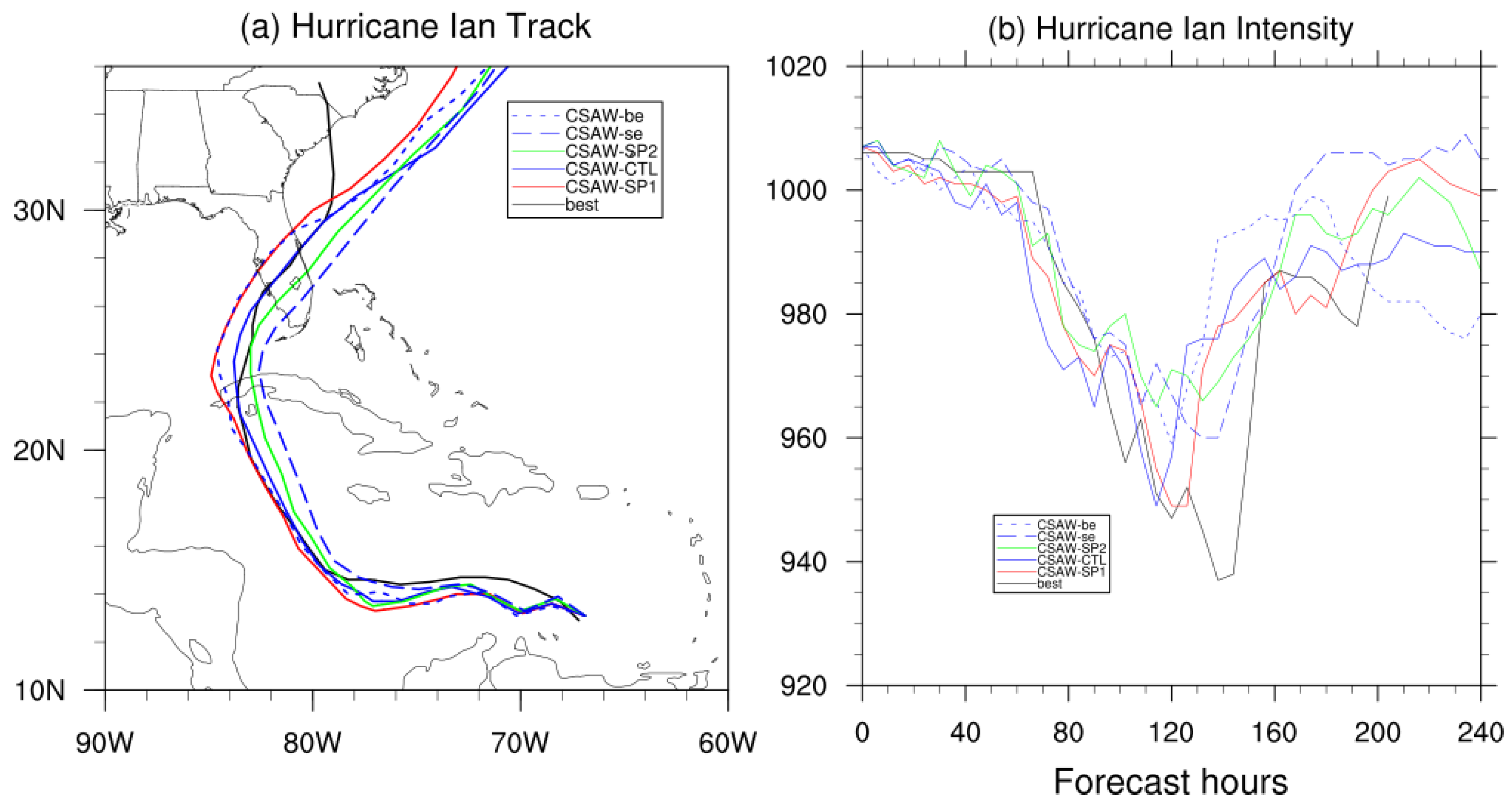
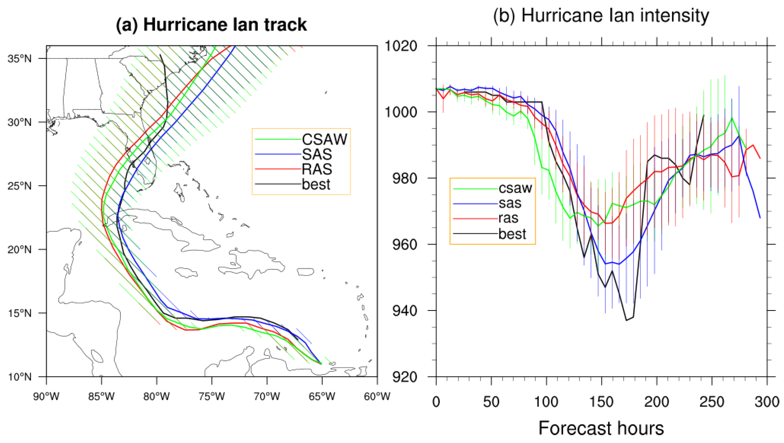
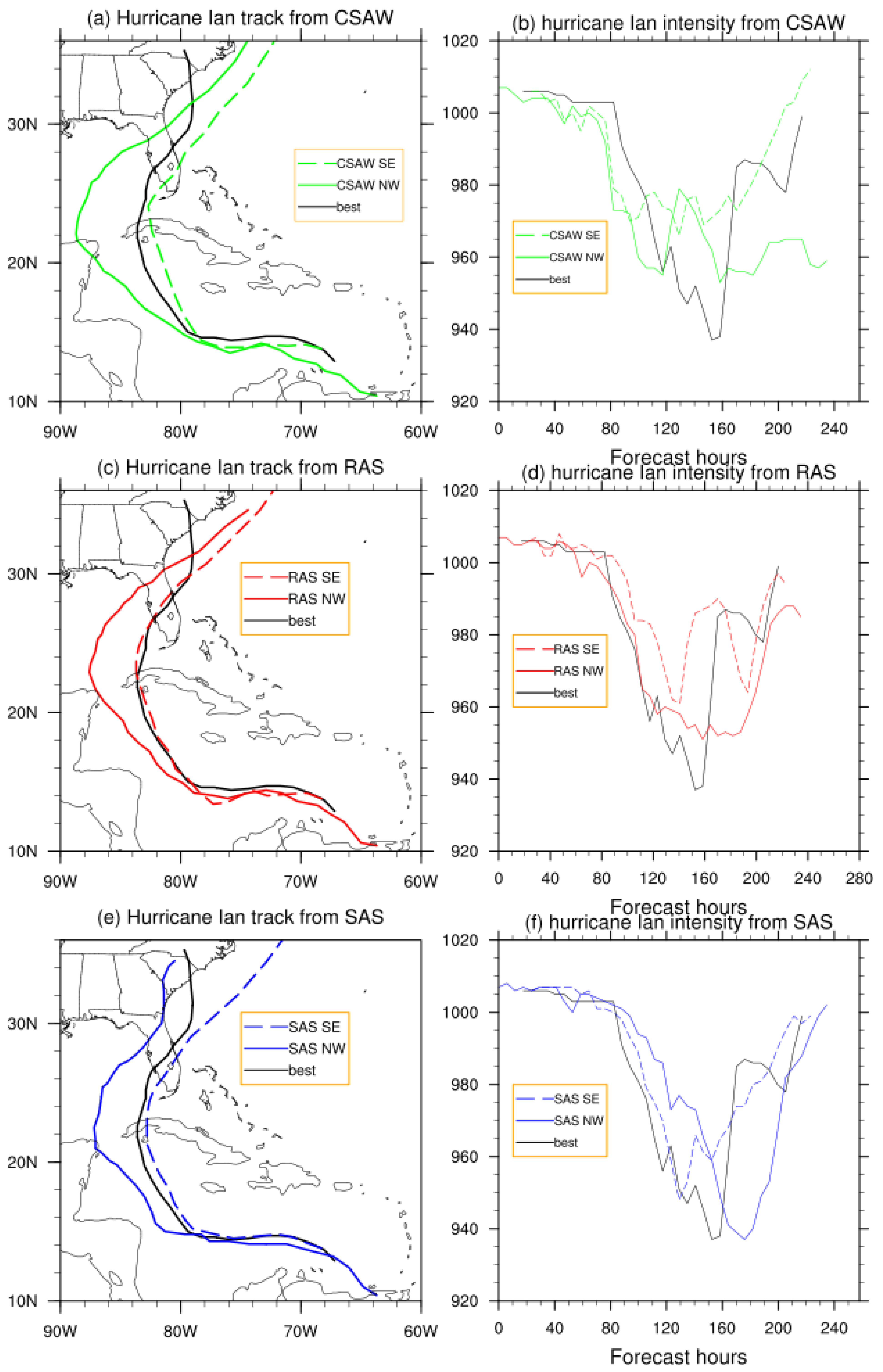
To take into account of the uncertainties in initial conditions (ICs), we conducted a suite of 240-h simulations with a set of nine distinct ICs for each scheme (SAS, RAS, and CSAW), with cycles initiated every 6 h from 00:00 UTC on 22 September 2022, to 00:00 UTC on 24 September 2022. The members are assembled to follow targeted observation time for analysis. Additionally, a series of sensitivity experiments was performed to evaluate the specific impacts of spectral representation and entrainment rate formulations on hurricane intensification and trajectory.
4. Discussions
The results represent a model-based dynamical interpretation, rather than a physical mechanism independently validated against observations. To our knowledge, no prior studies have investigated the specific sensitivity of hurricane track and intensity forecasts to cloud-base vertical velocity (Wb). While the impacts of entrainment on convective development and tropical cyclone evolution are well documented, research addressing how entrainment influences energy partitioning between resolved and unresolved scales within the convective gray zone remains limited. Because Wb can be constrained through direct observations, future empirical work is essential to evaluate its physical influence on moist convection and to calibrate sub-grid parameterization schemes. Furthermore, given the wide structural divergence in entrainment formulations across current cumulus parameterizations, rigorous validation against observational datasets remains a critical necessity.
While these findings are demonstrated using Hurricane Ian, similar sensitivities were observed in supplementary analyses of Hurricanes Harvey, Irma, and Matthew. Conducting more comprehensive evaluations across diverse seasonal regimes and distinct ocean basins remains a critical direction for future work. Furthermore, while our simulations show that reduced entrainment and an expanded Wb spectrum favor a rightward (eastward) track shift in the Atlantic basin, whether this relationship holds under different synoptic steering regimes—such as those in the Pacific basin—warrants further investigation.
5. Conclusions
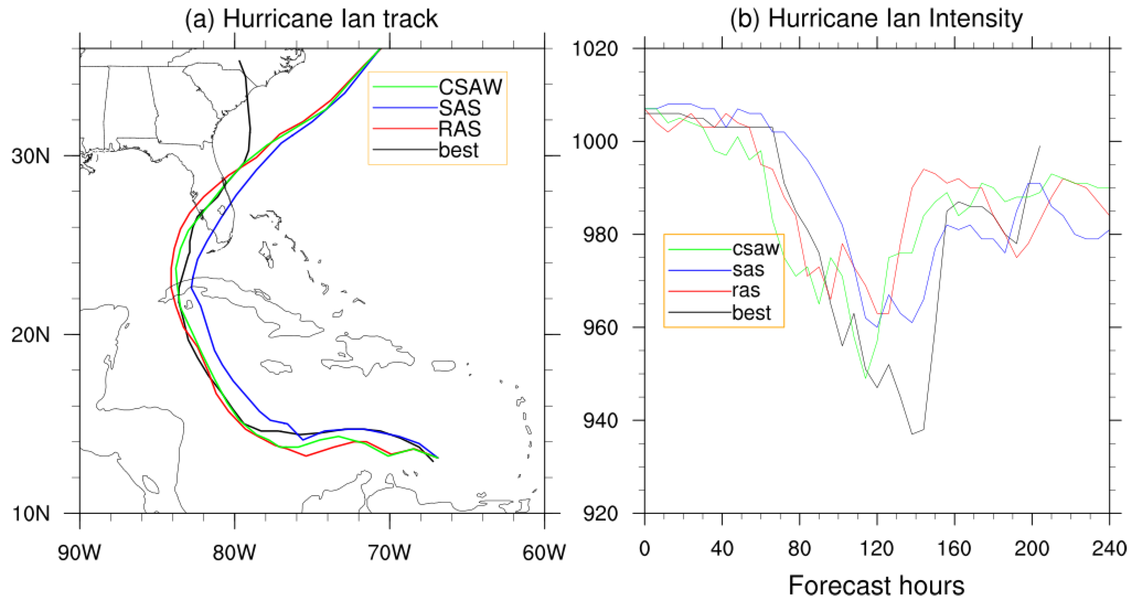
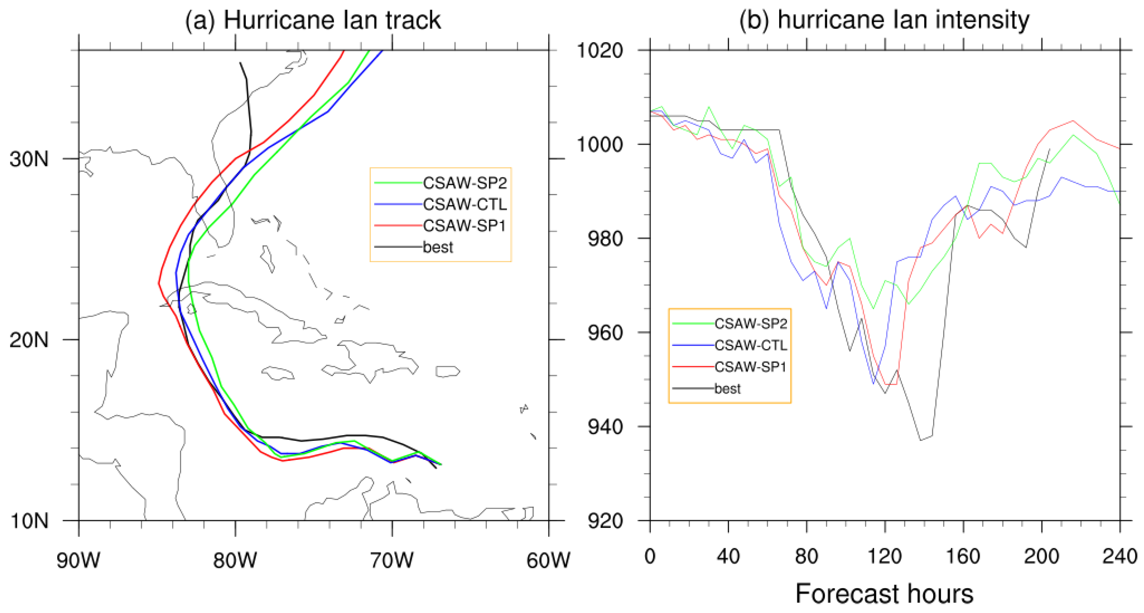
This study investigated the sensitivity of hurricane track and intensity forecasts to different cumulus parameterization schemes—SAS, RAS, and CSAW—using the GFS.v17 model at a horizontal resolution of 13 km. Our results demonstrate that schemes incorporating a spectrum of cloud types (RAS and CSAW) produce westward-shifted trajectories compared to the single-cloud SAS scheme, which exhibited at eastward bias. It was noted that the intensity in the CSAW framework is highly sensitive to internal parameters, specifically the cloud-base vertical velocity (Wb) and entrainment rates.
The investigation into the
Wb spectrum revealed a critical inverse relationship between parameterized convective strength and resolved hurricane intensity. Experiments with a narrower
Wb range (EXP SP1) or increased entrainment (CSAW-be) resulted in a weaker parameterized convective response. Paradoxically, this suppression of sub-grid scale activity facilitated a more robust intensification of the resolved vortex, consistent with the energy partitioning theories of [
4] and [
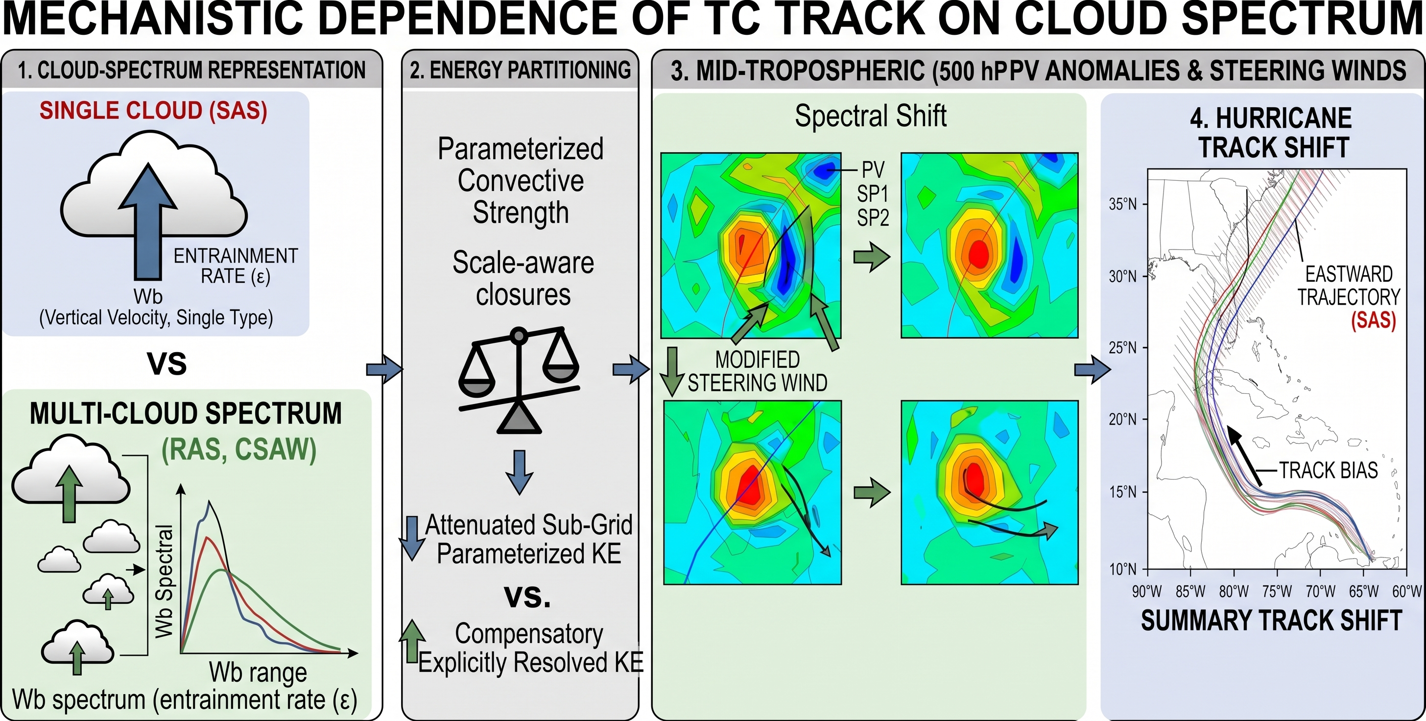
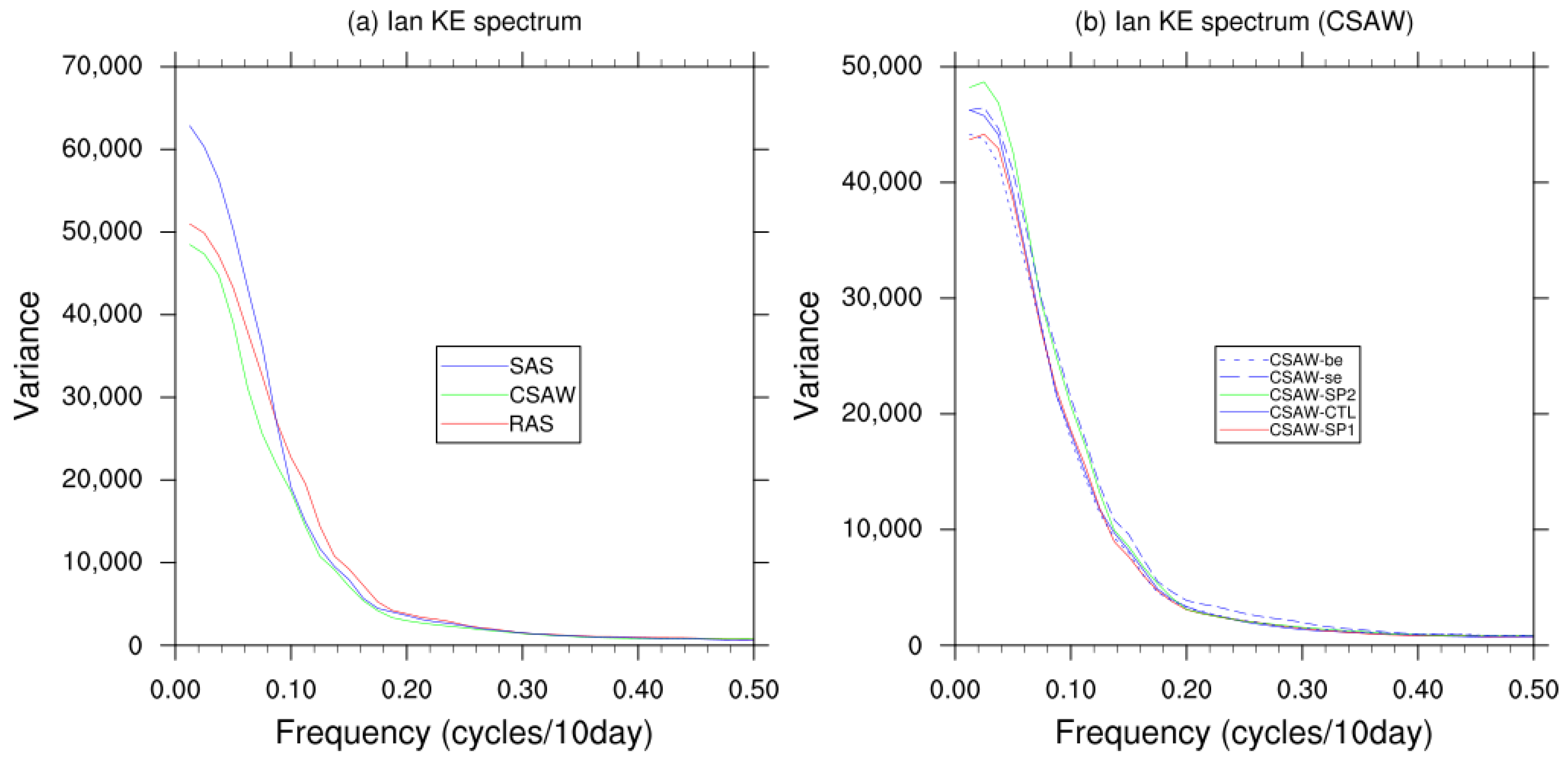
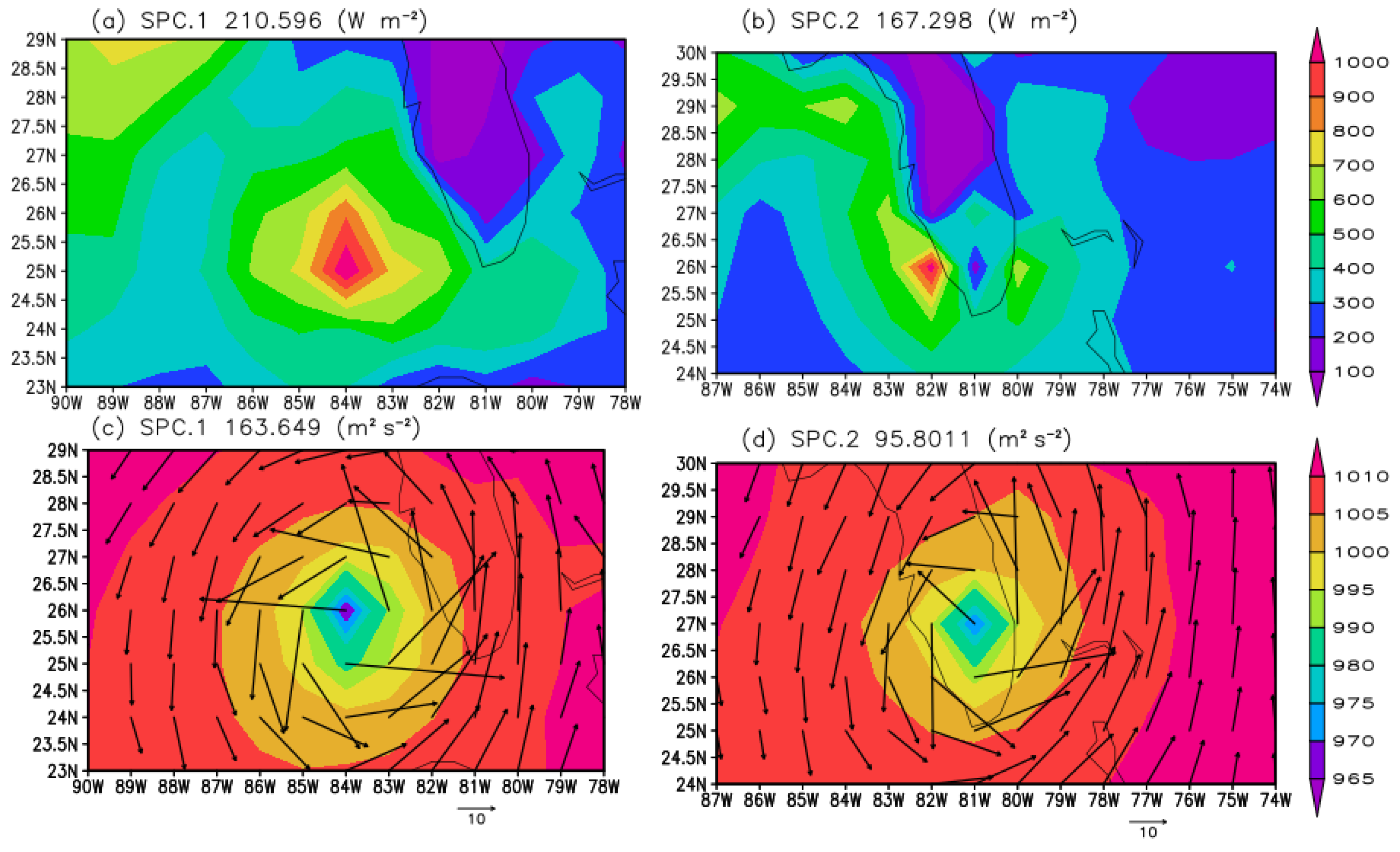
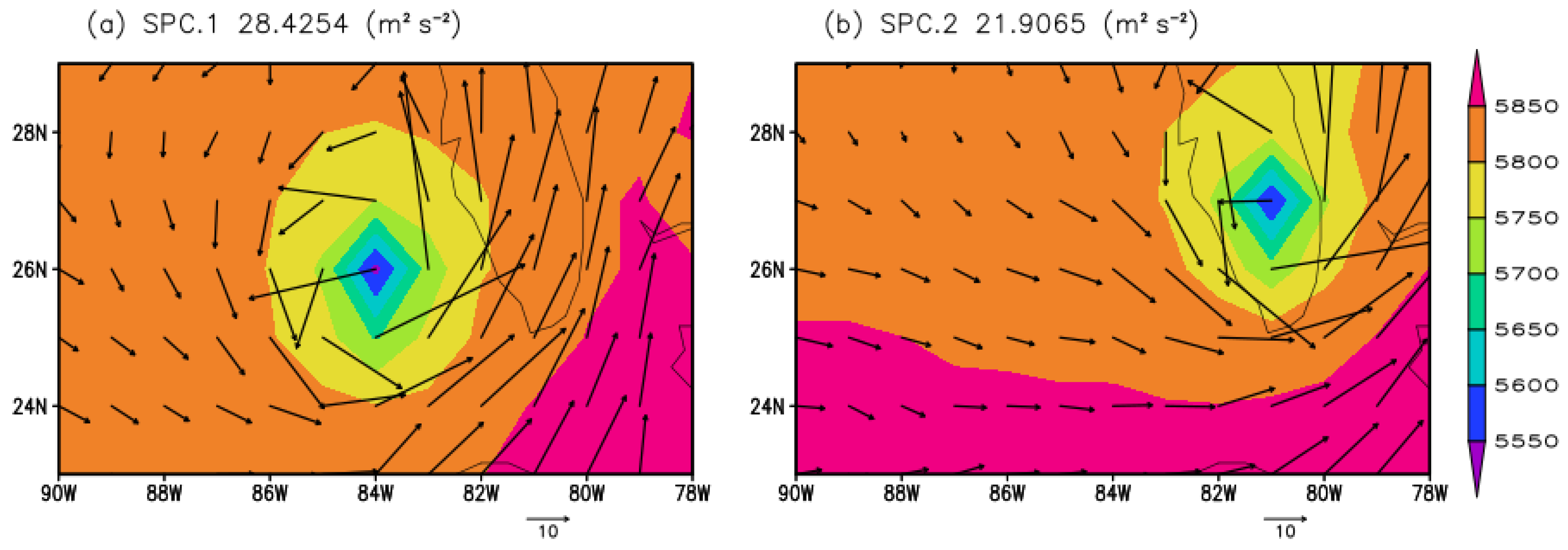
21]. Specifically, a reduction in parameterized kinetic energy allowed for a compensatory increase in resolved-scale kinetic energy, leading to a deeper and more organized storm. Spectral analysis further elucidated the dynamical drivers of these track deviations. Schemes with a cloud spectrum showed reduced energy variance in low-frequency modes, which are closely associated with large-scale easterly steering flows.
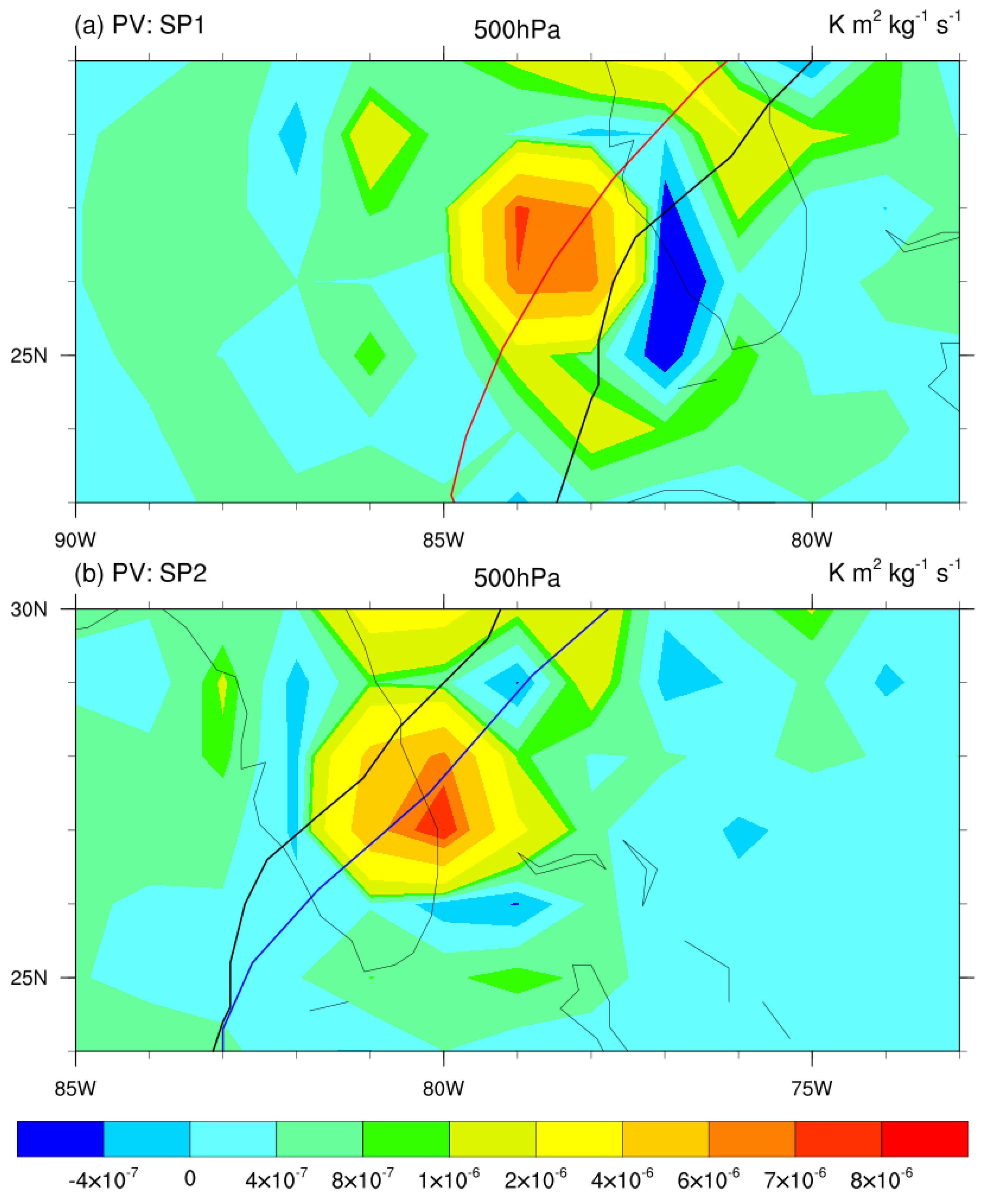
Furthermore, the results suggest that differences in the spatial orientation of PV anomalies may contribute to the simulated track divergence. In cases where the parameterization generated larger PV anomalies to the storm’s northwest (left-ward), the storm followed this gradient, whereas stronger westerlies in other configurations drove the storm further eastward. These findings underscore that the representation of the cloud spectrum is a control on both the thermodynamic intensification and the dynamical steering of tropical cyclones in high-resolution NWP models.
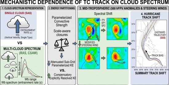
Based on our findings, we propose a coherent chain of mechanisms contributing tropical cyclone track evolution: cloud-spectrum representation, energy partitioning between parameterized and explicitly resolved scales, changes in potential vorticity and steering flow, and changes in hurricane track. Incorporating a multi-cloud spectrum (as in RAS and CSAW) distributes sub-grid moist convection across a range of updrafts, modulating convective kinetic energy and altering the spatial energy partitioning. Suppressing or spreading the parameterized convective activity limits sub-grid scale energy consumption, facilitating a compensatory increase in explicitly resolved-scale kinetic energy and inner-core storm strength. This altered energy distribution reconfigures diabatic heating profiles, which directly contributes the structural orientation and magnitude of 500-hPa potential vorticity (PV) anomalies surrounding the vortex. Because the storm center consistently propagates along the maximum local PV gradient, these diabatic PV shifts modulate the mid-tropospheric steering flow, ultimately driving systematic trajectory deviations such as the westward track shifts observed in multi-cloud formulations compared to single-cloud representations.